


Chapter 19.06
USE DISTRICTS, ZONING MAP AND ZONING CLASSIFICATIONS
Sections:
19.06.010 Use districts and map.
19.06.020 RC—Residential-conservation zone.
19.06.025 RLD—Residential-low density zone.
19.06.030 RG—Residential-general zone.
19.06.040 BG—Business-general zone.
19.06.050 BH—Business-Skagway historical zone.
19.06.060 IL—Industrial-light zone.
19.06.010 Use districts and map.
A. The Municipality of Skagway is divided into the following use districts:
RC—Residential-conservation zone
RLD—Residential low density
RG—Residential-general zone
BG—Business-general zone
BH—Business-Skagway historical zone
IL—Industrial-light zone
I—Industrial zone
W—Waterfront zone.
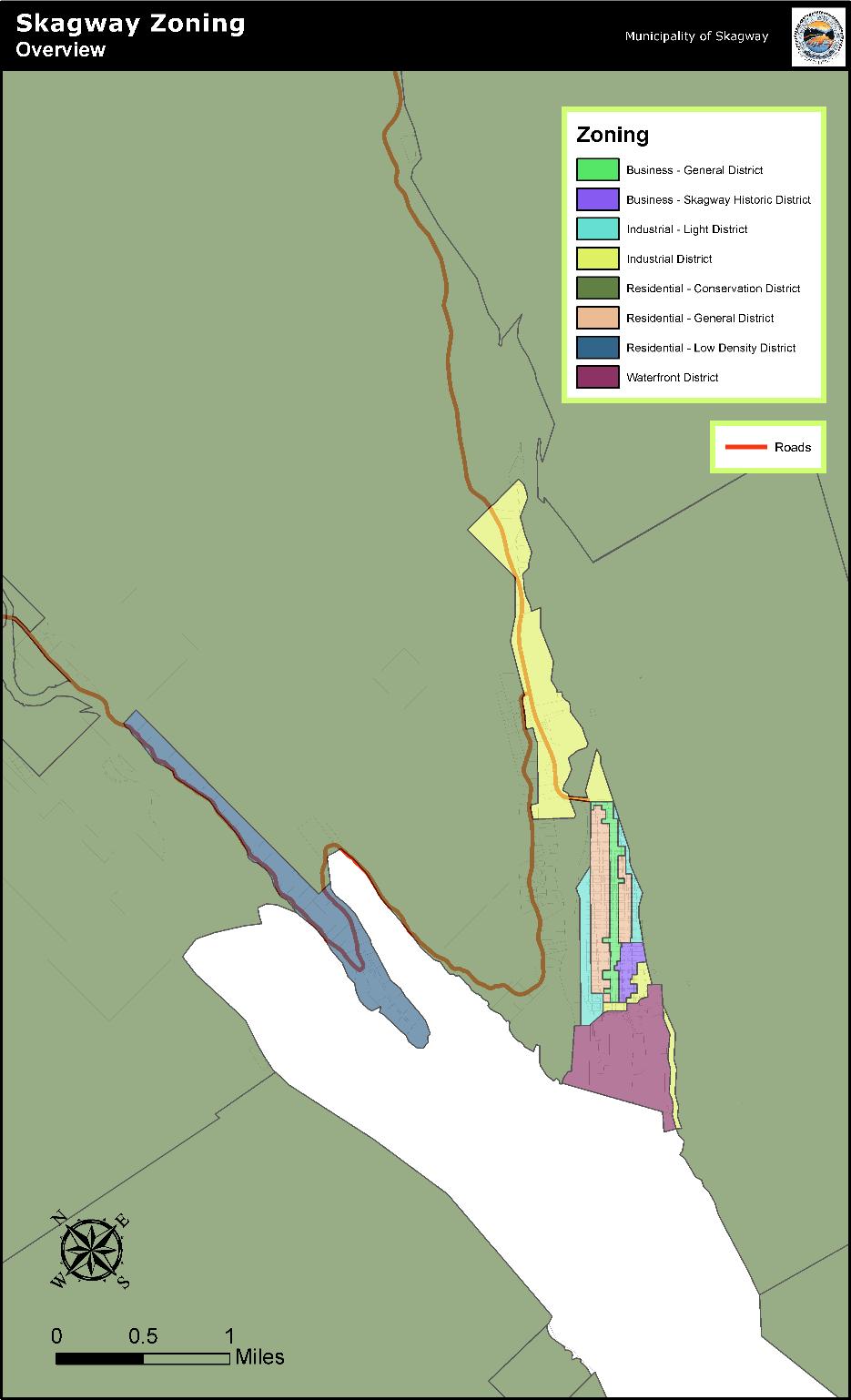
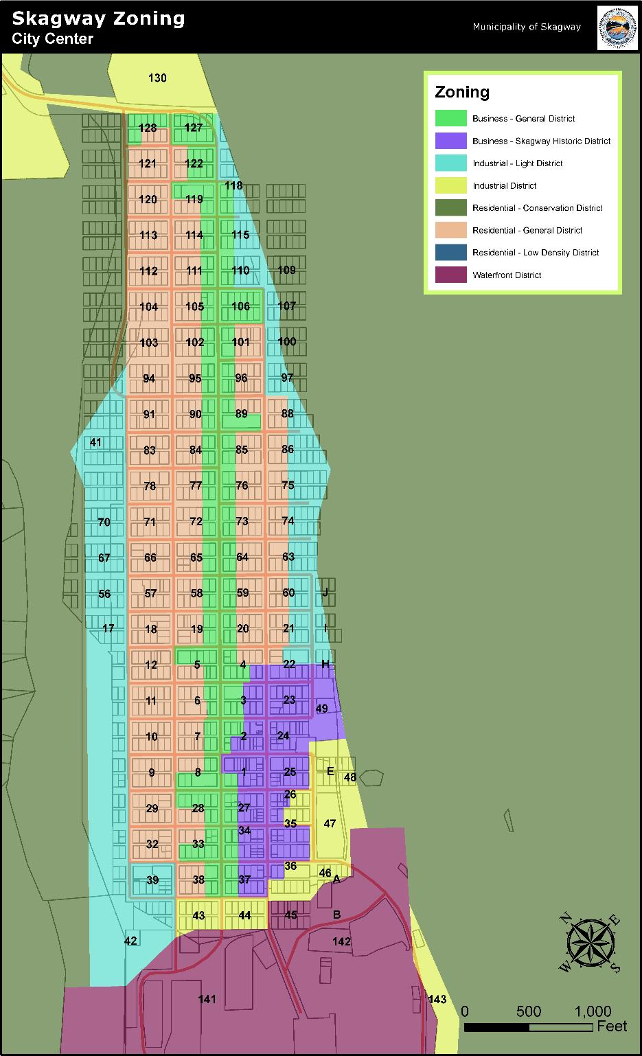
B. Map. The use districts are bounded and defined as shown on a map entitled "Zoning Map of the Municipality of Skagway," a certified copy of which is on file in the office of the borough clerk, and which, with all explanatory matter thereon, is hereby made a part of this chapter. A reproduction of this map is found in this chapter of the municipal code.
C. Map Changes. No changes of any nature shall be made in the official zoning map or matter shown thereon except in conformity with the procedures set forth in Section 19.04.080 of this title. Regardless of the existence of purported copies of the official zoning map which may from time to time be made or published, the official zoning map which shall be located in the office of the borough clerk shall be the final authority as to the current zoning status of land and water areas, buildings, and other structures in the municipality.
D. Map Replacement. In the event that the official zoning map becomes damaged, destroyed, lost or difficult to interpret because of the nature or number of changes and additions, the planning commission may, by resolution, adopt a new official zoning map which shall supersede the prior official zoning map. The new official zoning map may correct drafting or other errors or omissions in the prior official zoning map, but no such correction shall have the effect of amending the original zoning regulations or any subsequent amendment thereof. The new official zoning map shall be identified by the signature of the mayor, attested by the borough clerk, and bearing the seal of the municipality and the date of adoption.
(Ord. 15-20, Amended, 08/06/2015; Ord. 12-12, Amended, 05/17/2012; Ord. 08-16, Amended, 07/17/2008; Ord. 06-21, Amended, 12/07/2006; Ord. 06-02, Amended, 02/02/2006; Ord. 05-25, Amended, 01/26/2006; Ord. 05-17, Amended, 07/07/2005; Ord. 05-12, Amended, 05/26/2005; Ord. 04-02, Amended, 02/10/2004; Ord. 2000-05, Amended, 05/04/2000; Ord. 2000-02, Amended, 03/02/2000; Ord. 99-25, Amended, 09/16/1999; Ord. 99-04, Amended, 04/01/1999; Ord. 93-11, Amended, 06/03/1993; Ord. 92-16, Amended, 06/18/1992; Ord. 92-12, Amended, 05/21/1992; Ord. 92-07, Amended, 03/19/1992; Ord. 91-28, Amended, 09/05/1991; Ord. 90-15, Repealed & Replaced, 05/31/1990)
19.06.020 RC—Residential-conservation zone.
This zoning district is intended to provide an area for low-density residential development on adequate lot sizes not served by municipal water and sewer, to allow natural resource development and conservation, and to allow dispersed recreational activities including recreational cabins, lodges, and small seasonal recreational facilities.
Criteria for lands that are included in this zoning district are those that are relatively isolated from denser development due to natural features and the lay-of-the-land, and that are presently without any or all of the following: municipal water, municipal sewer, roads up to standard.
A. Uses Permitted.
1. Principal Uses.
a. Public parks and open space recreation;
b. Watershed reserve;
c. General agriculture and horticulture;
d. Single-family residences and duplexes;
e. Public water, sewer, electric and communication facilities.
2. Accessory Uses.
a. Uses and structures customarily accessory and clearly subordinate to permitted principal uses, as determined by the building official.
b. Storage structures: one (1) semi-trailer, freight container, storage trailer or van may be used as a storage shed per lot. Commercial markings and other markings detracting from its appearance in a residential zone must be removed. Wheeled storage containers or vans are not permitted for long term storage.
c. Home occupations; provided, that the conditions listed in Section 19.02.065(B)(37) are met.
d. Farmers’ markets in accordance with Section 19.02.065(B)(29).
3. Conditional Uses.
a. Churches;
b. Solid waste facilities;
c. Sand and gravel operations;
d. Mining and quarry operations;
e. Kennels;
f. Timber harvesting and storage;
g. Recreational cabins, lodges and small seasonal recreational facilities;
h. Commercial greenhouses;
i. Cemeteries;
j. Pipelines and railroads;
k. Campgrounds;
l. Temporary structures for residential use, used in conjunction with building or land development, for one (1) year;
m. Commercial recreation operations on municipal land;
n. Taverns and bars;
o. Restaurants serving alcohol;
p. Service stations;
q. Community gardens in accordance with Section 19.02.065(B)(19);
r. Retail marijuana stores, marijuana cultivation facilities, marijuana product manufacturing facilities, and marijuana testing facilities;
s. Accessory housing structures.
(i) Minimum of one hundred ninety (190) square feet.
(ii) Must have an Alaska Department of Environmental Conservation approved water system and sewer system, and must have electricity; all must meet current codes.
(iii) No setback variances will be granted for new construction.
(iv) All lot coverage, off-street parking, and setback requirements for this zone still apply.
(v) Construction must meet International Building Code for efficiency dwelling units;
t. Other uses as determined by the planning commission pursuant to Section 19.04.060(B).
B. Prohibited Uses.
1. Any use or structure not of a character indicated under permitted principal and accessory uses, or permitted by conditional uses.
2. Mobile homes.
3. Congregate residences.
4. Relocatable structures.
C. Minimum Lot Requirements.
1. Lot Area.
a. Forty thousand (40,000) square feet.
b. Except that all lots within the Hillside Subdivision, Blocks 1 and 2 created March 13, 2003 shall not be reduced in size.
2. Lot width, no requirement.
D. Minimum Building Setback Requirements.
1. Front yard, twenty-five feet (25');
2. Side yard, fifteen feet (15');
3. Rear yard, twenty-five feet (25');
4. Accessory building, five feet (5');
5. Setbacks between structures shall be regulated by the International Building Code, Tables 601 and 602.
E. Maximum Lot Coverage by Buildings. Twenty-five percent (25%).
F. Maximum Height of Buildings. Three (3) stories, but not to exceed thirty-five feet (35') in any case.
G. Parking Requirements. All requirements within Section 19.08.020, Provision of off-street parking, must be followed.
H. Sanitary Treatment System. Septic systems, leaching fields, or other private sewerage facilities may be permitted; provided, that the owner or developer submits plans stamped by an engineer licensed in Alaska, percolation and water table depth data suitable for analysis of the feasibility for on-lot water and sewer systems to the municipality and the Alaska Department of Environmental Conservation. Project applicants/owners are responsible for ensuring that their project meets all federal and state septic systems, leaching fields, or other private sewerage facility requirements.
I. Flood Protection. Some lands in the residential-conservation (RC) zoning district fall within the one hundred (100) year floodplain (Zone A6 on the Flood Hazard Boundary Maps). The planning or building official or planning commission must ensure that all requirements within Chapter 15.12, Flood Zone Land Use, are followed, particularly those at Section 15.12.040, that govern building and sanitary system construction in these areas.
J. Visibility at Intersections.
1. No vehicle shall be parked within twenty feet (20') of any street intersection;
2. To ensure that a vehicle’s driver has good visibility at street intersections, on corner lots there shall not be a fence, wall, hedge, or other planting or structure that will impede visibility between a height of two feet six inches (2'6") and eight feet (8') above the centerline grades of the intersecting streets.
(Ord. 22-02, Amended, 05/05/2022; Ord. 20-22, Amended, 02/04/2021; Ord. 16-04, Amended, 03/03/2016; Ord. 16-02, Amended, 02/18/2016; Ord. 15-03, Amended, 01/22/2015; Ord. 13-12, Amended, 05/10/2013; Ord. 12-12, Amended, 05/17/2012; Ord. 03-20, Amended, 11/20/2003; Ord. 03-05, Amended, 03/27/2003; Ord. 2002-10, Amended, 06/06/2002; Ord. 2002-02, Amended, 02/07/2002; Ord. 98-05, Amended, 04/23/1998; Ord. 90-15, Repealed & Replaced, 05/31/1990; Ord. 88-01, Amended, 01/07/1988; Ord. 84-26, Repealed & Replaced, 11/08/1984)
19.06.025 RLD—Residential-low density zone.
This zoning district is intended to provide for: an area for low- to moderate-density residential development on adequate lot sizes to preserve the natural beauty of the area; creating parks; prohibiting business, including tourism-business bases; limited housing rentals allowable by conditional use; and to create greenbelts and establish setback requirements adequate to preserve the viewshed and create small roadside parks and picnic areas, view points, and scenic overlooks along Dyea Bay.
Criteria for lands that are included in this zoning district are those that are relatively restricted in their development due to natural features and the lay-of-the-land, and that are presently without municipal water and municipal sewer.
A. Uses Permitted.
1. Principal Uses.
a. Public parks and open space recreation;
b. Watershed reserve;
c. Single-family residence;
d. Duplex; two (2) family residence;
e. One (1) private garage per living unit;
f. Noncommercial public water, sewer, electric and communication facilities;
g. Municipal public facilities such as fire department substation, solid waste transfer station, public works substation, and emergency services landing areas.
2. Accessory Uses.
a. Uses and structures customarily accessory and clearly subordinate to permitted principal uses, as determined by the building official;
b. Necessary outbuildings, accessory buildings not to exceed three hundred twenty (320) square feet per use as listed in subsections (A)(2)(b)(i) through (vi) of this section:
(i) One (1) storage shed per lot: a semi-trailer, freight container, house trailer, RV travel trailer, storage trailer or van; may not be used as a long term or permanent storage shed;
(ii) Generator shed;
(iii) Tool shed;
(iv) Private personal use greenhouse;
(v) Well house;
(vi) Wood shed;
c. Home occupations; provided, that the conditions listed in Section 19.02.065(B)(37) are met;
d. Private personal use gardens;
e. Farmers’ markets in accordance with Section 19.02.065(B)(29).
3. Conditional Uses.
a. Churches;
b. Day care facilities;
c. Temporary structures for residential use, used in conjunction with building or land development, for up to eighteen (18) months:
(i) "Temporary structure for residential use" means RV or trailer or other livable structure of at least one hundred (100) square feet with sanitary and kitchen facilities to be occupied during construction of a permanent residence that will be removed at the end of the eighteen (18) month construction period;
d. Accessory Housing Structures:
(i) Minimum of one hundred ninety (190) square feet;
(ii) Must have an Alaska Department of Environmental Conservation approved water system and sewer system, and must have electricity; all must meet current codes;
(iii) No setback variances will be granted for new construction;
(iv) All lot coverage, off-street parking and setback requirements for this zone still apply;
(v) Construction must meet International Building Code for efficiency dwelling units;
e. Commercial public water, sewer, electric, communication and other facilities;
f. Multiple storage structures or storage structures above three hundred twenty (320) square feet;
g. Taverns and bars;
h. Restaurants serving alcohol;
i. Service stations;
j. Community gardens in accordance with Section 19.02.065(B)(19);
k. Commercial greenhouses, agriculture and horticulture;
l. Retail marijuana stores, marijuana cultivation facilities, marijuana product manufacturing facilities, and marijuana testing facilities;
m. Other uses as determined by the planning commission pursuant to Section 19.04.060(B).
B. Prohibited Uses.
1. Any use or structure not of a character indicated under permitted principal and accessory uses, or permitted by conditional uses;
2. Mobile homes;
3. Congregate residences/apartment houses/multiple-family structures;
4. Sand and gravel operations;
5. Mining and quarry operations;
6. Kennels;
7. Timber harvesting and storage;
8. Cemeteries;
9. Pipelines and railroads;
10. Commercial recreation operations on municipal land;
11. Campgrounds;
12. Relocatable structures.
C. Minimum Lot Requirements.
1. Lot Area.
a. Property owners as of the date of the ordinance codified in this section may subdivide their property into no less than one (1) acre lots.
b. Two and one-half (2-1/2) acres.
c. Except that all lots within Taiya Inlet Subdivision created October 29, 2007, Plat # 2007-6 shall not be reduced in size.
2. Lot must be wide enough to provide access and other easements and setbacks.
D. Minimum Building Setback Requirements.
1. Road frontage, twenty-five feet (25');
2. All other lot lines, twenty feet (20');
3. Setbacks between structures shall be regulated by the International Building Code, Tables 601 and 602.
E. Maximum Lot Coverage by Buildings. Fifteen percent (15%).
F. Maximum Height of Buildings. Three (3) stories, but not to exceed thirty-five feet (35') in any case.
G. Parking Requirements. All requirements within Section 19.08.020, Provision of off-street parking, must be followed. Required off-street parking shall allow enough parking for all occupants to park all personal vehicles off-street.
H. Sanitary Treatment System. Septic systems, leaching fields, or other private sewerage facilities may be permitted; provided, that the owner or developer submits plans stamped by an engineer licensed in Alaska, percolation and water table depth data suitable for analysis of the feasibility for on-lot water and sewer systems to the municipality and the Alaska Department of Environmental Conservation. Project applicants/owners are responsible for ensuring that their project meets all federal and state septic systems, leaching fields, or other private sewerage facility requirements.
I. Flood Protection. Some lands in the residential-low density (RLD) zoning district may fall within the Taiya River floodplain (SCMP Figure 3.3 Natural Hazards Boundary Map). The planning or building official or planning commission must ensure that all requirements within Chapter 15.12, Flood Zone Land Use, are followed, particularly those at Section 15.12.040, that govern building and sanitary system construction in these areas.
J. Visibility at Intersections.
1. No vehicle shall be parked within twenty feet (20') of any street intersection;
2. To ensure that a vehicle’s driver has good visibility at street intersections, on corner lots there shall not be a fence, wall, hedge, or other planting or structure that will impede visibility between a height of two feet six inches (2' 6") and eight feet (8') above the centerline grades of the intersecting streets.
(Ord. 22-02, Amended, 05/05/2022; Ord. 20-22, Amended, 02/04/2021; Ord. 17-05, Amended, 04/20/2017; Ord. 16-04, Amended, 03/03/2016; Ord. 16-02, Amended, 02/18/2016; Ord. 15-03, Amended, 01/22/2015; Ord. 13-12, Amended, 05/10/2013; Ord. 12-12, Amended, 05/17/2012; Ord. 06-21, Added, 12/07/2006)
19.06.030 RG—Residential-general zone.
This zoning district includes single-family and multifamily residential housing. Single-family units, duplexes, and triplexes are allowed on five thousand (5,000) square foot lots, for an allowable density of sixteen (16) units per forty thousand (40,000) square feet. Multifamily residential units (four (4) units and above) are conditionally permitted, for a maximum allowable density of twenty-six (26) units per forty thousand (40,000) square feet.
This general residential zoning district is intended to provide an area for medium to high density residential development including single-family, duplex, triplex, and low-rise multifamily dwellings. The purpose of the zoning district is to promote a wide variety in housing types and design to meet the expanding demand for housing. The zoning district is designed for use in areas that provide full urban services and facilities.
Criteria for lands that are included in this zoning district are those that have water and sewer utilities, a developed road system, and that are close to commercial and/or industrial districts.
A. Uses Permitted.
1. Principal Uses.
a. Single-family residences;
b. Two (2) family duplexes;
c. Mobile homes north of 15th Avenue and mobile home parks north of 15th Avenue, per the standards at subsection (A)(3)(j) of this section;
d. Day care facilities;
e. Parks, playgrounds, play fields and other open space recreation areas.
2. Accessory Uses.
a. Private garages and required off-street parking;
b. Greenhouses and tool sheds;
c. Home occupations; provided, that the conditions listed in Section 19.02.065(B)(37) are met;
d. Storage structures; the standard at Section 19.06.020(A)(2)(b) applies in this zoning district;
e. Farmers’ markets in accordance with Section 19.02.065(B)(29).
3. Conditional Uses.
a. Multiple-family dwellings and apartment houses with three (3) or more units;
b. Bed and breakfast establishments, rooming, and other residences rented by the day or week;
c. Basement apartments;
d. Temporary structures for residential use, used in conjunction with building or land development, for eighteen (18) months;
e. Churches;
f. Public and private elementary and secondary schools;
g. RV parks; provided, that:
(i) The area is at least sixty thousand (60,000) square feet;
(ii) There is at least three hundred (300) square feet for each allotted RV space;
(iii) Approximately four feet (4') of space is maintained between parked recreational vehicles;
(iv) Utility connections are available for each RV;
(v) A bathhouse and restrooms are provided for overnight occupants;
(vi) No business other than the renting of RV space shall be conducted, except for self-service laundry facilities and vending machines for the use of the occupants of the RV park;
(vii) Chapter 15.15 shall additionally govern the location, building regulations and operation of RV parks, except that Section 15.15.040, Storage of RVs, shall not apply to conditionally permitted RV parks. The foregoing shall not relieve an RV park operator from complying in all particulars with this chapter when its provisions are not specifically preempted by Chapter 15.15;
h. Medical services;
i. Accessory Housing Structures.
(i) Minimum of one hundred ninety (190) square feet.
(ii) Must have water, sewer and electricity, meeting current codes.
(iii) No setback variances will be granted for new construction.
(iv) All lot coverage, off-street parking and setback requirements for this zone still apply.
(v) Construction must meet Uniform Building Code for efficiency dwelling units;
j. Mobile Home Parks North of 15th Avenue.
(i) Minimum size of mobile home park is ten thousand (10,000) square feet.
(ii) Minimum lot size for each mobile home is three thousand (3,000) square feet with a maximum lot coverage of fifty percent (50%).
(iii) Mobile homes must be on permanent foundations with skirting in place.
(iv) Chapter 15.14 shall additionally govern the location, building regulations and operation of mobile home parks, and to any extent conflicting with this chapter, Chapter 15.14 shall be controlling. The foregoing shall not relieve a mobile home park operator from complying in all particulars with this chapter when its provisions are not specifically preempted by Chapter 15.14;
k. Congregate residences that meet IBC code; provided, that:
(i) Occupancy does not exceed ten (10) persons on a five thousand (5,000) square foot parcel or twenty (20) persons on a ten thousand (10,000) square foot parcel.
(ii) There is a minimum of one (1) parking space for every three (3) persons.
(iii) Lot coverage by all buildings does not exceed fifty percent (50%).
(iv) A six foot (6') high solid fence shall be required on all lot lines bordering RG lots.
(v) A yard area for recreation and outdoor congregation is provided.
(vi) Subject to review every two (2) years and can be revoked for excessive noise complaints or congestion issues or for other reasons as determined by the planning official.
(vii) Maximum of one (1) congregate residence per city block;
l. Taverns and bars;
m. Restaurants serving alcohol;
n. Service stations;
o. Community gardens in accordance with Section 19.02.065(B)(19);
p. Marijuana cultivation facilities (indoor-only), marijuana product manufacturing facilities, and marijuana testing facilities;
q. Other uses as determined by the planning commission pursuant to Section 19.04.060(B).
B. Prohibited Uses.
1. Any use or structure not of a character indicated under permitted principal and accessory uses, or permitted by conditional uses.
2. Mobile homes or mobile home parks south of 15th Avenue.
3. Kennels.
4. Retail marijuana stores, marijuana cultivation facilities (outdoor-only).
5. Relocatable structures.
C. Minimum Lot Requirements.
1. Lot Area.
a. For a one (1), two (2), or three (3) family dwelling, five thousand (5,000) square feet;
b. For a multiple-family dwelling with four (4), five (5), or six (6) dwelling units, one thousand six hundred fifty (1,650) square feet per dwelling unit;
c. For a multiple-family dwelling with more than six (6) dwelling units, one thousand five hundred (1,500) square feet per dwelling unit;
d. For a mobile home park, each lot must be a minimum of three thousand (3,000) square feet.
2. Lot width, fifty feet (50').
D. Minimum Building Setback Requirements.
1. Front yard, ten feet (10');
2. Side Yard.
a. For a one (1) or two (2) family dwelling, five feet (5');
b. For a multiple-family dwelling unit with more than two (2) units, ten feet (10');
3. Rear yard, five feet (5');
4. Setbacks between structures shall be regulated by the International Building Code, Tables 601 and 602.
E. Maximum Lot Coverage by All Buildings. Fifty percent (50%). Marijuana cultivation facilities may not exceed five hundred (500) square feet in area.
F. Maximum Height of Buildings. Three (3) stories, but not to exceed thirty-five feet (35') in any case.
G. Parking Requirements. All requirements within Section 19.08.020, Provision of off-street parking, must be followed.
H. Visibility at Intersections. The standard at Section 19.06.020(J)(1) and (2) applies in this zoning district.
(Ord. 22-02, Amended, 05/05/2022; Ord. 20-22, Amended, 02/04/2021; Ord. 19-13, Amended, 09/19/2019; Ord. 18-07, Amended, 04/19/2018; Ord. 17-09, Amended, 07/20/2017; Ord. 16-04, Amended, 03/03/2016; Ord. 16-02, Amended, 02/18/2016; Ord. 15-03, Amended, 01/22/2015; Ord. 13-17, Amended, 07/11/2013; Ord. 13-12, Amended, 05/10/2013; Ord. 12-12, Amended, 05/17/2012; Ord. 2002-10, Amended, 06/06/2002; Ord. 2002-02, Amended, 02/07/2002; Ord. 98-05, Amended, 04/23/1998; Ord. 96-7 § 2, Amended, 04/04/1996; Ord. 95-1, Amended, 02/16/1995; Ord. 90-15, Repealed & Replaced, 05/31/1990; Ord. 88-01, Amended, 01/07/1988; Ord. 84-26, Repealed & Replaced, 11/08/1984)
19.06.040 BG—Business-general zone.
This zoning district is intended to provide for the commercial activities of the municipality. The purpose of the zoning district is to provide a centrally located area for general retail shopping, personal and professional services, entertainment establishments, restaurants, and similar businesses. Most commercial activities are permitted outright. The zoning district is also intended to accommodate a mixture of residential and commercial uses with conflicts being resolved in favor of commercial uses. Mixed commercial and residential use of structures is encouraged.
Criteria for lands that are included in this zoning district are those that have existing developed streets and utilities and where public investment has occurred to establish social and commercial services.
A. Uses Permitted.
1. Principal Uses.
a. Banks and offices;
b. Hotels;
c. Restaurants, not serving alcoholic beverages;
d. Theaters and bowling alleys;
e. Automobile repair garages;
f. Printing establishments;
g. Laundries of all types and dry cleaning establishments;
h. Retail stores and service shops;
i. Post offices;
j. Dwelling units;
k. Congregate residences as allowed by IBC; provided, that:
(i) Minimum lot size is five thousand (5,000) square feet and limited to one (1) building per five thousand (5,000) square feet.
(ii) A minimum of one (1) parking space for every three (3) occupants.
(iii) Lot coverage does not exceed sixty percent (60%) for all buildings.
(iv) A six foot (6') high solid fence shall be required on all lot lines bordering RG lots;
l. Taverns and bars;
m. Restaurants serving alcohol;
n. Service stations.
2. Accessory Uses.
a. Uses and structures customarily accessory and clearly subordinate to permitted principal uses, as determined by the building official;
b. Dwelling units on the same premises with permitted principal uses;
c. Storage structures;
d. Farmers’ markets in accordance with Section 19.02.065(B)(29).
3. Conditional Uses.
a. Business expansion of any uses allowed by principal or conditional use permitted in the BG zoning district; provided, that such expansion involves no more than one (1) lot adjacent to a lot line that is in common with the BG zoning district;
b. Assembly halls, fraternal and social organizations;
c. Funeral parlors;
d. Accessory Housing Structures.
(i) Minimum of one hundred ninety (190) square feet.
(ii) Must have stand-alone water, sewer and electricity, meeting current codes.
(iii) No setback variances will be granted for new construction.
(iv) Off-street parking and setback requirements for this zone shall apply.
(v) Construction must meet International Building Code Section 1207 for efficiency dwelling units.
(vi) Maximum of fifty percent (50%) lot coverage;
e. Community gardens in accordance with Section 19.02.065(B)(19);
f. Retail marijuana stores, marijuana product manufacturing facilities, marijuana cultivation facilities and marijuana testing facilities;
g. Other uses as determined by the planning commission pursuant to Section 19.04.060(B).
B. Prohibited Uses.
1. Any use or structure not of a character indicated under permitted principal and accessory uses, or permitted by conditional use.
2. Mobile homes and mobile home parks.
3. Kennels.
4. Structures creating lot coverage of greater than ninety percent (90%) for a lot of five thousand (5,000) square feet or larger.
5. Relocatable structures.
C. Minimum Lot Requirements.
1. Lot area, two thousand five hundred (2,500) square feet;
2. Lot width, twenty-five feet (25').
D. Minimum Building Setback Requirements.
1. Front yard, five feet (5').
2. Side yard, five feet (5').
3. Rear yard, five feet (5').
E. Maximum Lot Coverage by All Buildings. Ninety percent (90%) provided buildings comply with setback and parking requirements.
F. Maximum Height of Buildings. Three (3) stories, not to exceed thirty-five feet (35') in any case.
G. Parking Requirements. All requirements within Section 19.08.020, Provision of off-street parking, must be followed.
H. Landscaping or View Obscuring Screening. Whenever a proposed development is either adjacent to a residential structure or is on a lot with a lot line in common with a lot in the residential general (RG) zoning district, there shall be a six foot (6') high solid fence, vegetative barrier, or other view and noise obscuring screen to promote compatibility of land uses and mitigate negative visual impacts, junk, trash and debris shall be removed.
I. Visibility at Intersections. The standard at Section 19.06.020(J)(1) and (2) applies in this zoning district.
(Ord. 22-02, Amended, 05/05/2022; Ord. 20-22, Amended, 02/04/2021; Ord. 19-13, Amended, 09/19/2019; Ord. 16-02, Amended, 02/18/2016; Ord. 15-03, Amended, 01/22/2015; Ord. 13-12, Amended, 05/10/2013; Ord. 12-12, Amended, 05/17/2012; Ord. 2002-10, Amended, 06/06/2002; Ord. 2002-02, Amended, 02/07/2002; Ord. 98-05, Amended, 04/23/1998; Ord. 96-9 § 1 & 2, Amended, 04/04/1996; Ord. 96-7 § 3, Amended, 04/04/1996; Ord. 93-14, Amended, 07/15/1993; Ord. 90-15, Repealed & Replaced, 05/31/1990; Ord. 88-01, Amended, 01/07/1988; Ord. 84-26, Repealed & Replaced, 11/08/1984)
19.06.050 BH—Business-Skagway historical zone.
This zoning district is for the area of downtown Skagway with special historical significance. It is to allow commercial development whose buildings are in keeping with the architectural character of the historic Gold Rush era.
The historic district helps to safeguard the heritage of Skagway by preserving its cultural, social, economic, political and architectural history. For this reason, special regulations are applied to preserve or enhance its unique historic character.
A. Uses Permitted.
1. Principal Uses.
a. All uses as permitted in the BG zone, with the exception of those listed in subsection (B) of this section.
B. Prohibited Uses.
1. All buildings not in keeping with the architectural character of the historic or "Gold Rush" buildings in this zone;
2. Any use or structure not of a character indicated under the permitted principal and accessory uses, or permitted by conditional uses pursuant to Section 19.04.060(B);
3. Automobile repair garages;
4. Service stations;
5. Kennels;
6. Structures creating lot coverage of greater than ninety percent (90%) for a lot of five thousand (5,000) square feet or larger;
7. Relocatable structures.
C. Minimum Lot Requirements. No requirements.
D. Minimum Building Setback Requirements.
1. Front yard, buildings will have no more than a two foot (2') setback between the front facade and the boardwalk/property line;
2. Side yard, none required, except that there shall be a five foot (5') side yard when windows or doors are in a side wall of a proposed structure;
3. Rear yard, five feet (5').
E. Maximum Lot Coverage by All Buildings. A ninety percent (90%) coverage of lot(s) available shall be the maximum allowed in any case, for lots of five thousand (5,000) square feet or larger. This limitation helps meet setback, parking, life safety, utility and/or other requirements. The undeveloped portions of the lot(s) shall remain as contiguous as possible.
F. Maximum Height of Buildings. Three (3) stories, but not to exceed thirty-five feet (35') in any case.
G. Parking Requirements. All requirements within Section 19.08.020, Provision of off-street parking, must be followed.
H. All structures within the historic district shall comply with the provisions of Chapter 19.10, Historic District Commission and Administrative Provisions.
I. Approval by Historic District Commission.
1. No building shall be erected or altered without the approval of the historic district commission as to historical architectural adequacy.
2. The following criteria shall apply:
a. The facades of all structures shall be of a type similar to those existing around the turn of the century;
b. The height of all facades shall be not less than the average of all other buildings on the same block, but need not exceed twenty feet (20') in any case;
c. The facades of all structures shall be made of wood, or other natural material, but any material shall be acceptable for the rest of the structure;
d. Any style of interior decoration shall be acceptable;
e. Buildings, whenever possible, should cover the full width of the lot.
J. Visibility at Intersections. No vehicle shall be parked within twenty feet (20') of any street intersection.
K. Landscaping or View Obscuring Screening. Whenever a proposed development is either adjacent to a residential structure or is on a lot with a lot line in common with a lot in the residential general (RG) zoning district, there shall be a six foot (6') high solid fence, vegetative barrier, or other view and noise obscuring screen to promote compatibility of land uses and mitigate negative visual impacts, junk, trash and debris shall be removed.
(Ord. 20-22, Amended, 02/04/2021; Ord. 16-02, Amended, 02/18/2016; Ord. 05-22, Amended, 10/06/2006; Ord. 2001-18; Amended, 07/19/2001; Ord. 2001-19, Amended, 05/17/2001; Ord. 98-05, Amended, 04/23/1998; Ord. 96-9 § 3 & 4, Amended, 04/04/1996; Ord. 94-8, Amended, 05/19/1994; Ord. 90-15, Repealed & Replaced, 05/31/1990; Ord. 88-01, Amended, 01/07/1988; Ord. 84-26, Repealed & Replaced, 11/08/1984)
19.06.060 IL—Industrial-light zone.
This zoning district is intended to provide an area for urban and suburban light manufacturing, processing, storage, wholesaling and distribution, and railroad and airport related industry and business. This zoning district is intended to promote efficient use of the land while at the same time, allowing for a variety of compatible uses. Commercial uses are allowed, but with conflicts being resolved in favor of light industrial use. Existing residential uses between Alaska Street and the airport can continue without restrictions typically applied to nonconforming uses. Light industrial uses are those of a nature which do not produce dust, traffic, noise, odor, vibration, or other objectionable pollutants of a substantially greater intensity or duration than those commonly associated with the surrounding land use. Because of the impacts inherent in some industrial activities, performance standards, including screening, are applied to certain uses.
Criteria for lands included in this zoning district are those areas that are adjacent to major arterials, other light industrial users, and the airport or railroad.
A. Uses Permitted.
1. Principal Uses.
a. Airports, aircraft repair, and other air transportation and airplane related services;
b. Railroads;
c. Buried pipelines;
d. Fishery enhancement structures;
e. Storage buildings, mini-storage units;
f. Firms;
g. Offices, professional or administrative services;
h. Veterinary office (no outdoor kennels);
i. Communication services;
j. Retail sales of building materials, aircraft, rail, auto, or marine supplies;
k. Light equipment sales, storage and rentals for off-site use;
l. Small appliance repair;
m. Plant nurseries;
n. Aircraft, boat and RV storage;
o. Vehicle and equipment storage and parking;
p. Computer and office equipment sales and service;
q. Gunsmiths, locksmiths, and related services;
r. Marijuana product manufacturing facilities and marijuana testing facilities.
2. Accessory Uses.
a. Administrative offices, accessory to permitted uses;
b. Residential uses, accessory to industrial uses, such as watchman’s apartment, owner-operator’s home, necessary bunkhouses;
c. Farmers’ markets in accordance with Section 19.02.065(B)(29).
3. Conditional Uses.
a. Light custom manufacturing;
b. Heavy and light equipment repair and service;
c. Sale and storage of fuels, gases and Class I, II, and III liquids, flammables and explosives, in compliance with applicable fire codes;
d. Power generating facilities;
e. Residential dwelling units, including single-family, duplex, multifamily units, or mobile home parks north of 15th Avenue (provided, that the standards listed at Sections 19.06.030(A)(3)(j)(i) through (iii) are followed);
f. Congregate residences as allowed by IBC; provided, that:
(i) Minimum lot size is five thousand (5,000) square feet and limited to one (1) building per five thousand (5,000) square feet.
(ii) A minimum of one (1) parking space for every three (3) occupants.
(iii) Lot coverage does not exceed sixty percent (60%) for all buildings.
(iv) A six foot (6') high solid fence shall be required on all lot lines bordering RG lots;
g. Taverns and bars;
h. Restaurants serving alcohol;
i. Service stations;
j. Community gardens in accordance with Section 19.02.065(B)(19);
k. Retail marijuana stores and marijuana cultivation facilities;
l. Other uses as determined by the planning commission pursuant to Section 19.04.060(B).
B. Prohibited Uses.
1. Cemeteries;
2. Garbage dumps;
3. Junkyards;
4. All uses that may be noxious or injurious by reason of the production or emission of dust, smoke, refuse matter, odor, gas, fumes, noise, vibration, or similar substances or conditions;
5. Relocatable structures.
C. Minimum Lot Requirements.
1. Lot area, five thousand (5,000) square feet;
2. Lot width, fifty feet (50').
D. Minimum Building Setback Requirements.
1. Front yard, none required, except that there shall be a ten foot (10') setback required when the lot is adjacent to a major public street, or a business or residential zoning district.
2. Side yard, fifteen feet (15') except that no side yard shall be required along any lot line bordering on other lots in the W (waterfront) or IL (industrial-light) districts.
3. Rear yard, none required.
E. Maximum Lot Coverage by Buildings. No limitation, provided compliance with building setback and parking requirements.
F. Maximum Height of Buildings. Three (3) stories, but not to exceed thirty-five feet (35') in any case. A conditional use permit may be requested to build higher; see Section 19.04.060(B). Federal Aviation Administration approval required when necessary.
G. Parking Requirements. All requirements within Section 19.08.020, Provision of off-street parking, including those for industrial and manufacturing establishments, must be followed.
H. Landscaping or View Obscuring Screening. Whenever a lot line is in common with a major public street or is adjacent to business or residential zoned land, there shall be a six foot (6') high solid fence, vegetative barrier, or other view obscuring screening to promote compatibility of land uses and mitigate negative visual impacts. Junk, trash and debris shall be removed.
I. Visibility at Intersections. The standard at Section 19.06.020(J)(1) and (2) applies in this zoning district.
(Ord. 20-22, Amended, 02/04/2021; Ord. 16-02, Amended, 02/18/2016; Ord. 15-03, Amended, 01/22/2015; Ord. 13-12, Amended, 05/10/2013; Ord. 12-12, Amended, 05/17/2012; Ord. 2002-10, Amended, 06/06/2002; Ord. 98-05, Amended, 04/23/1998; Ord. 90-15, Repealed & Replaced, 05/31/1990; Ord. 88-01, Amended, 01/07/1988; Ord. 84-26, Repealed & Replaced, 11/08/1984)
19.06.070 I—Industrial zone.
This zoning district is intended to provide for an area where heavy industrial activities like manufacturing, processing, repairing, and assembling can take place. Proximity to railroad and waterfront transportation will likely be important for these activities. Because of the dust, smoke, refuse matter, odor, gas, fumes, noise, vibration, or similar substances or conditions inherent in some industrial activities, screening and other conditions may be applied to certain uses. The zoning district allows commercial and residential uses but with conflicts being resolved in favor of industrial uses.
Criteria for lands that are included in this zoning district are those areas which are adjacent to major arterials or other industrial users, and of sufficient size to allow heavy commercial activities. They should also be buffered from lower density users.
A. Uses Permitted.
1. Principal Uses.
a. Railroad and trucking transportation firms and yards;
b. The manufacturing, warehousing, compounding, processing, assembling, packaging, treatment, or fabrication of materials or property;
c. Storage of fuels and propane in compliance with applicable fire codes;
d. Junkyards and salvage yards screened from view from adjacent residences or public ways;
e. Heavy, light, and railroad related equipment repair and maintenance;
f. Vehicle and equipment storage;
g. Mining and quarry operations;
h. Sand and gravel operations;
i. Solid waste facilities;
j. Pipelines and railroads;
k. Kennels;
l. Commercial or private stabling of farm animals;
m. Administrative offices, accessory to industrial uses listed in subsections (A)(1)(a) through (l) of this section;
n. Farmers’ markets accessory to permitted principal uses in accordance with Section 19.02.065(B)(29);
o. Marijuana cultivation facilities, marijuana product manufacturing facilities, and marijuana testing facilities.
2. Conditional Uses.
a. Sale and storage of fuels, gases and Class I, II, and III liquids, flammables and explosives, in compliance with applicable fire codes;
b. Trailer parks; provided, that:
(i) The area is at least sixty thousand (60,000) square feet;
(ii) There are at least two thousand (2,000) square feet for each allotted trailer space and one thousand (1,000) square feet for each pickup camper space;
(iii) Utility connections are available for each trailer;
(iv) A bathhouse and restrooms are provided for overnight occupants;
(v) No business other than the renting of trailer space shall be conducted, except for self-service laundry facilities and vending machines for the use of the occupants of the trailer court;
(vi) Chapters 15.14 and 15.15 shall additionally govern the location, building regulations and operation of trailers, mobile homes and mobile home parks, and to any extent conflicting with this chapter, Chapters 15.14 and 15.15 shall be controlling. The foregoing shall not relieve a trailer owner or trailer park operator from complying in all particulars with this chapter when its provisions are not specifically preempted by Chapters 15.14 and 15.15;
c. Residential uses, accessory to industrial uses listed in subsections (A)(1)(a) through (l) of this section, such as watchman’s apartment, owner-operator’s home, and necessary bunkhouses;
d. Congregate residences north of the 23rd Street bridge as allowed by IBC; provided, that:
(i) The residential use is accessory to the industrial use.
(ii) Minimum lot size is forty thousand (40,000) square feet.
(iii) A minimum of one (1) parking space for every three (3) occupants.
(iv) Lot coverage does not exceed sixty percent (60%) for all buildings.
(v) A six foot (6') high solid fence or vegetative barrier shall be required on all lot lines bordering RC lots;
e. Taverns and bars;
f. Restaurants serving alcohol;
g. Service stations;
h. Community gardens in accordance with Section 19.02.065(B)(19);
i. Retail marijuana stores;
j. Other uses and structures customarily contingent and clearly subordinate to permitted uses, as determined by the planning commission pursuant to Section 19.04.060;
k. Relocatable structures.
B. Prohibited Uses.
1. Cemeteries;
2. Garbage dumps;
3. Junkyards, unless completely surrounded by a fence at least six feet (6') in height;
4. Uses that degrade air, water, or land resources’ quality without mitigative measures that alleviate impacts;
5. Residential, except as otherwise defined.
C. Minimum Lot Requirements.
1. Lot area, forty thousand (40,000) square feet in industrial zone north of 23rd Street bridge; five thousand (5,000) square feet in industrial zone south of 23rd Street bridge;
2. Side yard, fifteen feet (15'), except that no side yard shall be required along any lot line bordering on other lots in the industrial (I) zoning district;
3. Rear yard, none required;
4. Setbacks shall be ten (10') feet from state highways.
D. Maximum Lot Coverage by Buildings. No limitation, provided compliance with building setback and parking requirements.
E. Maximum Height of Buildings. Three (3) stories, but not to exceed thirty-five feet (35') in any case. A conditional use permit may be requested to build higher; see Section 19.04.060.
F. Parking Requirements. All requirements within Section 19.08.020, Provision of off-street parking, including those for industrial and manufacturing establishments, must be followed.
G. Sanitary Treatment System. Septic systems, leaching fields, or other private sewerage facilities may be permitted; provided, that the owner or developer submits plans stamped by an engineer licensed in Alaska, percolation and water table depth data suitable for analysis of the feasibility for on-lot water and sewer systems to the municipality and the Alaska Department of Environmental Conservation. Project applicants/owners are responsible for ensuring that their project meets all federal and state septic systems, leaching fields, or other private sewerage facility requirements.
H. Landscaping or View Obscuring Screening. Whenever a lot line is in common with a major public street or adjacent to a business or residential zoned lot, there shall be a six foot (6') high solid fence, vegetative barrier, or other view obscuring screening to promote compatibility of land uses and mitigate negative visual impacts. Junk, trash and debris shall be removed.
I. Flood Protection. Some lands in the industrial (I) zoning district fall within the one hundred (100) year floodplain (Zone A6 on the Flood Hazard Boundary Maps). The planning or building official, or planning commission must ensure that all requirements within Chapter 15.12, Flood Zone Land Use, are followed, particularly those at Section 15.12.040, that govern building and sanitary system construction in these areas.
J. Visibility at Intersections. The standard at 19.06.020(J)(1) and (2) applies in this zoning district.
(Ord. 20-22, Amended, 02/04/2021; Ord. 16-02, Amended, 02/18/2016; Ord. 15-03, Amended, 01/22/2015; Ord. 13-12, Amended, 05/10/2013; Ord. 12-12, Amended, 05/17/2012; Ord. 2002-10, Amended, 06/06/2002; Ord. 99-21, Amended, 08/05/1999; Ord. 98-05, Amended, 04/23/1998; Ord. 90-15, Repealed & Replaced, 05/31/1990; Ord. 88-1, Amended, 01/07/1988; Ord. 84-26, Repealed & Replaced, 11/08/1984)
19.06.080 W—Waterfront zone.
The waterfront zoning district is intended for all property contiguous with the shoreline. This is to protect Skagway’s limited, developable waterfront areas for those uses that are directly dependent upon, or directly related to, the water, a waterfront location, or both. This is also to allow special consideration to the development, growth, public use and appearance of Skagway’s waterfront, the municipality’s most heavily utilized area. Water-dependent and water-related industrial and commercial uses have priority in this zoning district. Consideration is also given to maintaining safety, public access and an attractive appearance. Intended activities include those that derive major economic or social benefits from a waterfront location, with particular emphasis on industrial, tourism, commerce and commercial enterprises.
Criteria for including lands in this zoning district are those lands adjacent to the shoreline of Taiya Inlet.
A. Uses Permitted. (Note that the special policies outlined in subsection (C) of this section must be followed when a building permit or conditional use permit for private or public sector development in this zone is obtained.)
1. Principal Uses.
a. Public, private, and commercial moorage;
b. Warehousing, storage and handling of cargo; provided, however, that:
(i) No use shall be constructed or operated so as to cause excessive noise, vibration, smoke, dust or other particulate matter, toxic or noxious matter, humidity, heat or glare, at or beyond any lot line of the lot on which it is located. "Excessive" is defined for these purposes as a degree exceeding that caused by customary manner of operation by uses permitted in the district, or a degree injurious to the public health, safety, or welfare.
c. Marine fuel, water, sanitation facilities;
d. Research and educational facilities related to the adjacent waterbody;
e. Port and harbor facilities including docks, floatplane operations, barge freight terminals, and ferry terminals;
f. Seafood processing plants, cold storage plants and facilities;
g. Boat storage yards;
h. Fish and shellfish propagation;
i. Parks and open space;
j. Administrative offices, accessory to waterfront uses listed in subsections (A)(1)(a) through (i) of this section;
k. Farmers’ markets accessory to permitted principal uses in accordance with Section 19.02.065(B)(29).
2. Conditional Uses.
a. Heliport;
b. Manufacturing, processing, repair or sales related to maritime activity that requires or benefits from a shoreline location;
c. Hotels and motels;
d. Sale and storage of fuels, gases and Class I, II, and III liquids, flammables and explosives, in compliance with applicable fire codes;
e. Water-dependent or related visitor industry services (not retail);
f. Residential uses, accessory to waterfront uses listed in subsections (A)(1)(a) through (i) of this section, such as watchman’s apartment, owner-operator’s home, necessary bunkhouses or congregate residence;
g. Taverns and bars;
h. Restaurants serving alcohol;
i. Service stations;
j. Community gardens in accordance with Section 19.02.065(B)(19);
k. Other uses and structures customarily contingent and clearly subordinate to permitted uses, as determined by the planning commission pursuant to Section 19.04.060.
B. Prohibited Uses.
1. Any use or structure not of a character indicated under permitted uses, or permitted by conditional uses.
2. Uses which degrade air, water, or land resources’ quality without mitigative measures to alleviate impacts.
3. Residential, except as otherwise defined.
4. Retail marijuana stores, marijuana cultivation facilities, marijuana product manufacturing facilities, and marijuana testing facilities.
C. Special Policies. In addition to the general requirements set forth in Section 19.06.040, the following special policies will apply in the waterfront district:
1. To maintain and enhance public access and use, safety and the general appearance of Skagway’s heavily used downtown waterfront, applicants are required to spend five percent (5%) of the total project cost on the amenities described at subsection (C)(1)(d) of this section. Amenities may be proposed for the specific site development plan or on other borough-owned waterfront land, as approved by the borough assembly. Applicants for a building, allowable use or conditional use permit will submit a plan to the zoning or building official or planning commission showing project development with special attention to:
a. Buffers, screening, and sound fences between adjacent uses;
b. Parking;
c. Public access to the waterfront;
d. Amenities such as landscaping, walkways, bikepaths and bike racks, windscreens, water and fish viewing areas, picnic areas and interpretive displays.
2. Compliance with the Skagway Coastal Management Program shall be strictly enforced within the waterfront district. Particular attention will be given to Coastal Development Policies, the Pullen Creek Area Meriting Special Attention (AMSA) Policies, and the Port of Skagway AMSA policies.
3. Public access to the water and hatchery-related activities shall be emphasized within the Pullen Creek area. There shall be a fifty foot (50') wide buffer strip protected from development, measured from the centerline of the creek, on either side of Pullen Creek.
D. Minimum Lot Requirements.
1. Lot area, two thousand (2,000) square feet.
2. Lot width, fifty feet (50').
E. Minimum Building Setback Requirements.
1. Front yard, twenty feet (20').
2. Side yard, twenty feet (20').
3. Rear yard, twenty feet (20').
4. Accessory buildings, ten feet (10').
F. Maximum Lot Coverage by Buildings. None.
G. Maximum Height of Buildings. No limitation.
H. Parking Requirements. All requirements within Section 19.08.020, Provision of off-street parking, including those for industrial and manufacturing establishments, must be followed.
I. Landscaping or View Obscuring Screening. Whenever a lot line is in common with a major public street or adjacent to a business or residential zoned lot, there shall be a six foot (6') high solid fence, vegetative barrier, or other view obscuring screening to promote compatibility of land uses and mitigate negative visual impacts. Junk, trash and debris shall be removed.
J. Visibility at Intersections. The standard at Section 19.06.020(J)(1) and (2) applies in this zoning district.
(Ord. 22-02, Amended, 05/05/2022; Ord. 20-22, Amended, 02/04/2021; Ord. 16-02, Amended, 02/18/2016; Ord. 15-03, Amended, 01/22/2015; Ord. 13-12, Amended, 05/10/2013; Ord. 12-12, Amended, 05/17/2012; Ord. 2002-10, Amended, 06/06/2002; Ord. 99-21, Amended, 08/05/1999; Ord. 98-05, Amended, 04/23/1998; Ord. 90-15, Repealed & Replaced, 05/31/1990; Ord. 84-26, Repealed & Replaced, 11/08/1984)