


Appendix 1.2
Additional Information on Smart Growth and Traditional Neighborhood Developments
Sections:
1.2.010 What Is Smart Growth?
1.2.020 What Is New Urbanism and Traditional Neighborhood Development?
1.2.030 SmartCode
1.2.040 Transect-Based Planning and Form-Based Codes
1.2.050 A Brief Overview of Design Charrettes
1.2.060 Thoroughfares (i.e. Streets) in Traditional Neighborhoods
1.2.070 Online Resources for Smart Growth and Traditional Neighborhood Developments
1.2.010 What Is Smart Growth?
A. “Growth is smart when it gives us great communities, with more choices and personal freedom, good return on public investment, greater opportunity across the community, a thriving natural environment, and a legacy we can be proud of to leave our children and grandchildren.” (Smart Growth Network)
B. Smart Growth as promoted by the Smart Growth Network (www.smartgrowth.org) is based on the following principles:
1. Mix land uses.
2. Take advantage of compact building design.
3. Create a range of housing opportunities and choices.
4. Create walkable neighborhoods.
5. Foster distinctive, attractive communities with a strong sense of place.
6. Preserve open space, farmland, natural beauty, and critical environmental areas.
7. Strengthen and direct development towards existing communities.
8. Provide a range of transportation choices.
9. Make development decisions predictable, fair and cost effective.
10. Encourage community and stakeholder collaboration in development decisions.
C. Smart Growth principles when properly applied in a community provide a number of important benefits that can include:
1. Added value to a community through new development;
2. A greater return on investment for cities and towns through new development;
3. A variety of transportation choices – walking, biking, transit and driving – for residents to get to convenient amenities (e.g. schools, libraries, shops and restaurants);
4. A mix of housing and neighborhood types that meet the needs of couples, singles, families and seniors;
5. Greater opportunities for the preservation of open space; and
6. Development and urban growth patterns that are more sustainable than conventional development.
1.2.020 What Is New Urbanism and Traditional Neighborhood Development?
A. The term traditional neighborhood development (TND) has been utilized in planning and development circles within the City since November 2001 when the General Plan was first adopted. Indeed, the General Plan contains numerous references to, and actively promotes the use of, TND. With the undertaking of the Zoning Code update, the TND has been incorporated as an integral part of this Zoning Code.
B. New urbanism emerged over the past two decades in response to the urban sprawl that has characterized development in most parts of America. From its earliest roots up to the first quarter of the last century, the United States developed in the form of compact, mixed-use neighborhoods. Urban development patterns began to change with the emergence of modern architecture and zoning and the expanded use of the automobile. Following World War II, neighborhoods were replaced with development patterns that separated land uses, i.e., conventional suburban development, or sprawl.
C. New urbanism is an approach to urban planning and design that can be applied at a variety of scales, moving from a single block in an urban area to a large metropolitan region. At the neighborhood level, new urbanism is often referred to as traditional neighborhood development because it revives the urban form and character of U.S. cities and towns built from the 1600s until World War II.
Figure 1.2A
Early Mixed-Use Compact Traditional Neighborhood Development in the United States.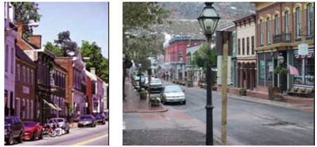
D. New Urbanist developments do not seek to mimic past patterns of development. Instead, New Urbanist or traditional neighborhood developments strive to reinterpret the qualities of old patterns of building placement, design and public spaces to suit modern living needs, including of course the needs of the automobile.
Figure 1-2B
A New Traditional Neighborhood Recently Completed in Denver, CO.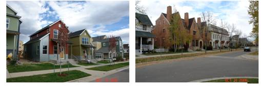
E. New urbanism and traditional neighborhood developments are based on principles of planning and architecture that work together to create human-scale, walkable, functional and sustainable communities. They can be applied to either infill developments within a city, communities proposed on the periphery of cities, developments focused on transit-oriented development (TOD), or even entire cities.
F. From modest beginnings, the New Urbanist movement is now having a substantial impact on development in the U.S. More than 600 new towns, villages and neighborhoods are planned or under construction in the U.S., using the principles of the new urbanism. Additionally, hundreds of small-scale new urban infill developments are restoring the urban fabric of cities and towns by reestablishing walkable streets and blocks. Many Gulf Coast communities ravished by hurricanes Katrina and Rita are rebuilding themselves based on these principles.
G. Principles of Traditional Neighborhood Development. The heart of the new urbanism is in the design of neighborhoods, which can be defined by 13 elements, according to town planners Andres Duany and Elizabeth Plater-Zyberk, who founded the architecture and town planning firm Duany Plater-Zyberk & Co., and who are also two of the founders of the Congress for the New Urbanism (www.cnu.org). An authentic neighborhood should contain most of these elements:
1. The neighborhood has a discernible center. This is often a square or a green and sometimes a busy or memorable street corner. A transit stop would be located at this center.
2. Most of the dwellings are within a five-minute walk of the center, an average of roughly 2,000 feet.
3. There are a variety of dwelling types – usually houses, rowhouses and apartments – so that younger and older people, singles and families, the poor and the wealthy may find places to live.
4. At the edge of the neighborhood, there are shops and offices of sufficiently varied types to supply the weekly needs of a household.
5. A small ancillary building is permitted within the backyard of each house. It may be used as a rental unit or place to work (e.g., office or craft workshop).
6. An elementary school is close enough so that most children can walk from their home.
7. There are small playgrounds accessible to every dwelling – not more than a tenth of a mile away.
8. Streets within the neighborhood form a connected network, which disperses traffic by providing a variety of pedestrian and vehicular routes to any destination.
9. The streets are relatively narrow and shaded by rows of trees. This slows traffic, creating an environment suitable for pedestrians and bicycles.
10. Buildings in the neighborhood center are placed close to the street, creating a well-defined outdoor room.
11. Parking lots and garage doors rarely front the street. Parking is relegated to the rear of buildings, usually accessed by alleys.
12. Certain prominent sites at the termination of street vistas or in the neighborhood center are reserved for civic buildings. These provide sites for community meetings, education, and religious or cultural activities.
13. The neighborhood is organized to be self-governing. A formal association debates and decides matters of maintenance, security, and physical change. Taxation is the responsibility of the larger community.
H. Flagstaff has some excellent older traditional neighborhoods like the Old Town Site neighborhood, Southside neighborhood, and the neighborhoods to the north and northwest of the downtown area. These neighborhoods, as well as the downtown area itself, provide a wealth of planning and architectural patterns that can be interpreted and applied in other areas of the City through the application of traditional neighborhood developments.
Figure 1-2C
Photographs Showing Some Architectural Elements that Reflect the City of Flagstaff’s Mountain Architectural Vernacular.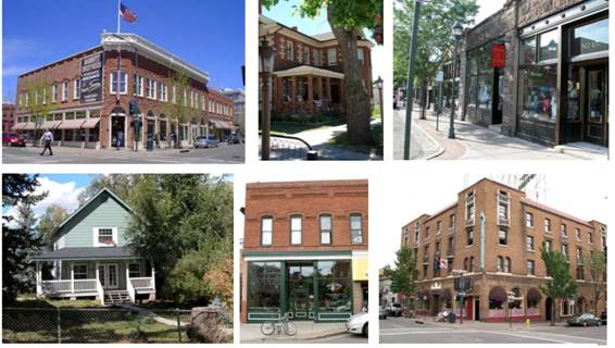
Figure 1-2D
Artist Renderings Showing the Urban Character of a Proposed TND Project (Juniper Point)
Reflecting the City of Flagstaff’s Mountain Architectural Vernacular, with a Corner Store on the Left, and a Residential Street on the Right.
Illustrations by Dover, Kohl & Partners.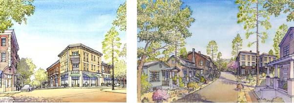
1.2.030 SmartCode
A. The SmartCode is a model unified land development ordinance for planning and urban design. It is the property of Duany Plater-Zyberk & Co. (DPZ) but may be freely reproduced and used with proper credit given to DPZ. The SmartCode incorporates smart growth and new urbanism principles, transect-based planning, environmental and zoning regulations, and regional, community and building-scaled design outcomes. It is a tool that guides the form of the built environment to resemble that of traditional neighborhoods, towns and villages. As noted previously, this form is compact, walkable, and mixed-use, and it is meant to be comfortable, safe and ecologically sustainable. As a model code, the SmartCode is intended to be calibrated or customized to the specific region within which it is applied by professional urban designers, planners, architects, engineers and other professionals, with the participation of local citizens. The SmartCode may be downloaded for free from http://smartcodecentral.com.
B. The principles of smart growth and traditional neighborhood development are addressed in the SmartCode at the scale of the region, the community, the block and the building, and the transect as provided below. This text is taken from the SmartCode and has been adapted to Flagstaff.
1. The Region.
a. That its natural infrastructure and visual character should be derived from its unique location in northern Arizona, and its topography, forests, farmlands, and riparian corridors.
b. That growth strategies should encourage infill and redevelopment in parity with new communities.
c. That development contiguous to urban areas should be structured in the neighborhood pattern and be integrated with the existing urban pattern.
d. That development noncontiguous to urban areas should be organized in the pattern of traditional neighborhoods.
e. That affordable housing should be distributed throughout the region to match job opportunities and to avoid concentrations of poverty.
f. That the planning and reservation of transportation corridors should be coordinated with land use planning.
g. That open space green corridors should be used to define and connect urbanized areas.
h. That the region should include a framework of transit, pedestrian, and bicycle systems that provide alternatives to the automobile.
i. That natural resources should be preserved by encouraging the concentration of development in mixed-use higher density neighborhoods than might otherwise be permitted under existing zoning.
2. The Community.
a. That neighborhoods should be coordinated, compact, pedestrian-oriented and mixed-use.
b. That neighborhoods should be the preferred pattern of development and that districts specializing in single-use should be the exception.
c. That ordinary activities of daily living should occur within walking distance of most dwellings, allowing independence to those who do not drive.
d. That interconnected networks of thoroughfares should be designed to disperse and reduce the length of automobile trips.
e. That within neighborhoods, a range of housing types and price levels should be provided to accommodate diverse ages and incomes.
f. That appropriate building densities and land uses should be provided within walking distance of transit stops.
g. That civic, institutional, and commercial activity should be embedded in downtowns or other planned neighborhood centers, not isolated in remote single-use complexes.
h. That schools should be sized and located to enable children to walk or bicycle to them.
i. That a range of useable open space including parks, squares and playgrounds should be distributed within neighborhoods and urban zones.
j. That public trails within neighborhoods should link to the existing regional trail system.
3. The Block and the Building.
a. That buildings and landscaping should contribute to the physical definition of thoroughfares as civic places.
b. That development should adequately accommodate automobiles while respecting the pedestrian and the spatial form of public space.
c. That the design of thoroughfares and buildings should reinforce safe environments, but not at the expense of accessibility.
d. That architecture and landscape design should grow from local climate, topography, history and building practice and therefore respect and support Flagstaff’s unique forest and mountain environment and architectural vernacular.
e. That buildings should provide their inhabitants with a clear sense of geography and climate through energy efficient methods.
f. That civic buildings and public gathering places should be located in places that reinforce community identity and support self-government.
g. That civic buildings should be distinctive and appropriate to a role more important than the other buildings that constitute the fabric of the City.
h. That the preservation and renewal of historic buildings should be facilitated to affirm the continuity and evolution of society.
i. That the harmonious and orderly evolution of urban areas should be secured through the adoption of form-based codes that serve as guides for change for the proposed traditional neighborhood district. The form-based code establishes land use regulations for the district that may be different from zoning regulations applicable to other zoning districts in the Zoning Code or any other approved traditional neighborhood district.
1.2.040 Transect–Based Planning and Form–Based Codes
A. The SmartCode provides a detailed overview of the transect from an ecological perspective, and how transects can also be applied in an urban-to-rural context. As this concept is critical in understanding the application of the SmartCode to the proposed traditional neighborhood district in the City, an overview of transect-based planning is provided in the Preamble to this Zoning Code.
B. Form-based codes address the relationship between building facades and the public realm, the form and mass of buildings in relation to one another, and the scale and types of streets and blocks. The regulations and standards in form-based codes, presented in both diagrams and words, are keyed to a regulating plan that designates the appropriate form and scale (and therefore character) of development rather than only distinctions in land use types. This is in contrast to conventional zoning’s focus on the segregation of land use types, permissible property uses, and the control of development intensity through simple numerical parameters (e.g., floor area ratio, dwellings per acre, height limits, setbacks, parking ratios). Not to be confused with design guidelines or general statements of policy, form-based codes are regulatory, not advisory. An overview of form-based codes is provided in the Preamble to this Zoning Code, Chapter 10.00.
1.2.050 A Brief Overview of Design Charrettes
This synopsis of design charrettes is taken from a publication written by Bill Lennertz called “The Charrette as an Instrument of Change,” and published in New Urbanism: Comprehensive Report & Best Practices Guide, Third Edition, Ithaca NY: New Urban Publications, 2003. Pp. 12-2 to 12-8. Additional information is also available from the National Charrette Institute website – www.charretteinstitute.org.
A. A charrette is a multi-day planning process during which an interdisciplinary professional design team creates a complete and buildable plan (typically based on smart growth and traditional neighborhood principles) that reflects the input of all stakeholders who are involved by engaging them in a series of feedback loops. It is a comprehensive and intensive planning process to bring transformative change to a neighborhood or planning area.
B. As Mr. Lennertz states, “charrettes offer much more than just a quick fix,” and they result in lasting, transformative change. A charrette requires a carefully planned and orchestrated process that starts well before the actual charrette and continues long after it.
C. The National Charrette Institute (NCI) suggests that there are nine strategies that differentiate an authentic charrette from other planning processes. Further information on these strategies is available at the NCI website.
1. Work collaboratively;
2. Design cross-functionally;
3. Use design to achieve a shared vision and create holistic solutions;
4. Work in detail;
5. Constrain work schedules;
6. Communicate in short feedback loops;
7. Work for at least four to seven consecutive days;
8. Work on-site; and
9. Produce a buildable plan.
1.2.060 Thoroughfares (i.e., Streets) in Traditional Neighborhoods
There is an extensive amount of information available on the subject of context sensitive design and the design of streets to promote walkability and safety for pedestrians. An excellent resource on this subject can found in a chapter titled “Designing Streets for Walkability and Safety” by various authors in the book New Urbanism: Comprehensive Report & Best Practices Guide, Third Edition, Ithaca NY: New Urban Publications, 2003. Pp. 8-1 to 8-30.
The following introduction to this subject is excerpted from the above referenced book, Pp. 8-1 to 8-2 in the chapter titled “Designing Streets for Walkability and Safety” by various authors.
A. A traditional neighborhood development (TND) is a human scale, walkable community with moderate to high residential densities and a mixed-use core. Compared with conventional suburban developments, TNDs have a higher potential to increase modal split by encouraging and accommodating alternate transportation modes. TNDs also have a higher potential for capturing internal trips, thus reducing vehicle miles traveled.
Figure 1-2E
Example of a Street
Designed to Promote Walkability and Safety for Pedestrians.
Photo by Rick Hall.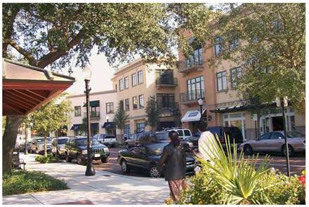
B. A dense network of narrow streets with reduced curb radii is fundamental to TND design. This network serves to both slow and disperse vehicular traffic and provide a pedestrian friendly atmosphere. Such alternate guidelines are encouraged by North Carolina Department of Transportation when the overall design ensures that nonvehicular travel is to be afforded every practical accommodation that does not adversely affect safety considerations. The overall function, comfort, and safety of a multipurpose or “shared” street are more important than its vehicular efficiency alone.
C. TNDs have a high proportion of interconnected streets, sidewalks and paths. Streets and rights-of-way are shared between vehicles (moving and parked), bicycles, and pedestrians. The dense network of TND streets function in an interdependent manner, providing continuous routes that enhance non-vehicular travel. Most TND streets are designed to minimize through traffic by the design of streets and the location of land uses. Streets are designed to only be as wide as needed to accommodate the usual vehicular mix for that street while providing adequate access for moving vans, garbage trucks, fire engines and school buses.
1.2.070 Online Resources for Smart Growth and Traditional Neighborhood Developments
Smart Growth:
http://www.smartgrowth.org
Traditional Neighborhood Development:
http://www.tndtownpaper.com/neighborhoods.htm
http://safety.fhwa.dot.gov/ped_bike/
http://www.newurbannews.com/
http://www.tndhomes.com/feature.htm
http://www.preservenet.com/politics/NewUrb.html
http://fullyarticulated.typepad.com/sprawledout/2007/06/traditional_nei.html
Congress for the New Urbanism:
http://www.cnu.org/
Transect:
http://www.transect.org/
http://www.dpz.com/transect_articles.htm
Form-Based Codes:
http://www.formbasedcodes.org/
SmartCode:
http://www.smartcodecentral.com
Design Charrettes:
http://www.charretteinstitute.org
Context Sensitive Solutions:
http://www.contextsensitivesolutions.org/
http://www.fhwa.dot.gov/context/index.cfm
http://www.pedshed.net
http://www.completestreets.org