


Appendix 5
Additional Information Applicable to Division 10-50.90, Resource Protection Standards
Sections:
5.010 Purpose
5.020 Implementation of the Flagstaff Fire Department (FFD) Firewise Process
5.030 Summary of How to Apply Resource Protection Standards
5.010 Purpose
This appendix provides additional information relative to the application of standards to protect rural floodplains, steep slopes and forest resources as required in Division 10-50.90, Resource Protection Standards. Section 5.020 describes how the Flagstaff Fire Department implements various codes to ensure that Flagstaff is a firewise community by providing an overview of the stewardship programs that typically occur before forest resources are calculated on a site subject to new development. Section 5.030 provides an overview of how to apply the standards for the protection of rural floodplains, steep slopes and forest resources as required in Division 10-50.90, Resource Protection Standards.
5.020 Implementation of the Flagstaff Fire Department (FFD) Firewise Process
A. The International Code Council (ICC) International Wildland Urban Interface Code (WUI) current edition (in 2006 the City adopted the edition which may be updated in the future as new editions are published) was adopted with amendments into Title 5 (Fire Prevention Code) of the City Code in February 2008.
B. With regard to wildland stewardship, forest health and community protection from wildfire, the City has a number of documents that are closely related. The Resource Protection Standards in the Zoning Code (Division 10-50.90) are applied subsequent to the implementation of these documents/processes. The figure below summarizes the resource protection process in Flagstaff.
Figure 5-020A
Summary of the Tree Resource Process
As Applied by the Flagstaff Fire Department
|
|
Applies to Greater Flagstaff: |
|
Establishes priorities for protecting Flagstaff from wildfire. |
|
|
|
|
|
Internal to City: |
|
|
A general statement of what needs to occur to protect Flagstaff from fire and to restore a healthy forest. |
|
|
|
|
|
Site Specific Operations: |
|
|
Essentially implements the WUI on a development site. |
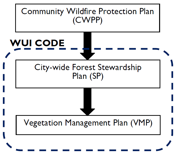
1. Community Wildfire Protection Plan (CWPP).
a. The Healthy Forests Restoration Act passed by Congress in November 2003 authorizes development of CWPPs.
b. The CWPP has been adopted by the Council and the Coconino County Board of Supervisors and has been approved by the State of Arizona.
c. The CWPP is consistent with the Governor’s “Statewide Strategy for Restoring Arizona’s Forests.”
d. It establishes priorities for protecting Greater Flagstaff (actually a bigger area than the FMPO boundary) from wildfire by establishing goals, policies and strategies for the long term protection of Greater Flagstaff from wildfire.
2. City-Wide Forest Stewardship Plan by the Flagstaff Fire Department.
a. The City-wide forest stewardship plan essentially implements the WUI Code.
b. It is implemented within the Flagstaff city limits only.
c. The plan is a generic statement of coordination of the general issues and of what needs to occur to protect the community from fire and to restore forest health.
3. Site Specific Vegetation Management Plan.
a. A vegetation management plan implements the WUI Code on a site-specific basis.
b. It establishes site-specific operations for tree thinning or removal.
c. It is a refinement of the City-wide forest stewardship plan.
5.030 Summary of How to Apply Resource Protection Standards
The following narrative provides a step-by-step summary of resource protection requirements and procedures as specified in Division 10-50.90, Resource Protection Standards. This division should be referred to for additional information.
A. The City of Flagstaff Overlay District Map (available at www.flagstaff.az.gov/zoningcode) should be consulted to determine whether the proposed development site is subject to resource protection standards. All parcels located within the Resource Protection Overlay (RPO) are subject to resource protection (See Section 10-40.50.030(A)(4), Resource Protection Overlay).
B. The minimum amount of resources required to be retained and protected on the subject site must be determined.
1. Floodplain Resources. Defined in Section 10-50.90.040, Floodplains, these include urban and rural floodplains. While urban floodplains may sometimes be disturbed (subject to review and approval by the Stormwater Manager), rural floodplains must remain undisturbed. Rural floodplains are mapped in Section 10-90.40.030, Rural Floodplain Map.
2. Steep Slope Resources. Table 10-50.90.050.A, Slope Protection Thresholds, indicates the slope area which must be protected based upon the steepness of the slope and the zone in which the site is located. A methodology for calculating steep slopes on a site is provided in Section 10-50.90.050(C).
3. Forest Resources. Table 10-50.90.060.A, Forest Resource Protection Thresholds as a Percentage of Site Area, establishes the minimum amount of forest resources that must be retained on the site by land use category.
4. The table below provides a summary of resource protection factors as a percentage of site area according to the zone/land use in which the site is located.
|
Resource Type |
Public Lands |
Residential |
Commercial |
Industrial |
TNCP |
|---|---|---|---|---|---|
|
Rural Floodplain |
100% |
||||
|
Urban Floodplain |
N/A1 |
||||
|
Slopes: |
|||||
|
0 – 16.99% |
No protection required |
||||
|
17% – 24.99% |
60% |
70% |
60% |
60% |
70% |
|
25% – 34.99% |
80% |
||||
|
35% and greater |
No development allowed2 |
||||
|
Forest |
30% |
50% |
30% |
20% |
30% |
|
End Notes: |
|||||
|
1 Proposed disturbances to urban floodplains shall be reviewed by the Stormwater Manager. |
|||||
|
2 Even though no development is allowed on areas with slopes of 35% and greater, these slope areas may be used to determine the overall resource area to be protected. |
|||||
C. A resources survey for the site is required to be completed in compliance with the requirements of Section 10-50.90.070, Resources Survey Requirements. This survey requires the identification of all natural resources on the site and a recommendation for protection and/or mitigation measures. The necessary maps (topographic, aerial photograph, etc.) and a narrative describing each resource as it exists on the development site shall also be provided in accordance with the following:
1. Floodplains: Section 10-50.90.040, Floodplains;
2. Steep slopes: Section 10-50.90.050, Steep Slopes; and
3. Forest: Section 10-50.90.060, Forest, and Sections 10-50.90.070(C)(3) through (9), and 10-50.90.070(D).
D. The details of how to calculate the amount of resources to be protected on a site are explained in the narrative below. An example site is described in subsection (F) of this section.
1. Rural Floodplains. Calculate the area of the development site located in rural floodplains, as designated on the Rural Floodplain Map (Division 10-90.30). Indicate these areas on a topographic map of the development site, and include a narrative describing these areas. Apply the protection thresholds summarized in the table to determine the areas required for protection of rural floodplains.
2. Steep Slopes. Calculate the total area of the development site located in areas designated as steep slopes, as defined in Table 10-50.90.050.A, Slope Protection Thresholds. Indicate the required area of each slope category to be protected on a topographic map of the development site by applying the protection thresholds summarized in the table above to the total area with slopes. Include a narrative describing these areas.
3. Forest Resources. Submit maps and a narrative describing the forest resources located on the development site.
a. Determine the minimum percentage of forest resources which must be protected on the development site as designated in Table 10-50.90.060.A, Forest Resource Protection Thresholds as a Percentage of Site Area.
b. Provide a description of the ecological value of the ponderosa pine forest located on the development site, based upon tree size, condition and location.
c. Perform a survey of forest resources located on the development site, with required methods of survey dependent upon the size of the site. Note that the survey of forest resources will commence after any required pre-thinning as approved by the Flagstaff Fire Department has been completed.
(1) For sites less than five acres in size, 100 percent of the site must be surveyed for forest resources.
(2) For sites five or more acres in size, sampling of forest resources may be employed, using the following procedure to ensure that a diverse sample of the forest is achieved:
(a) The total site area shall be sampled by using a technique that distributes one-tenth acre circular plots across a minimum of 15 percent of the site. The one-tenth acre circular plots shall be distributed across the site on a series of transect lines. The distance between the sample plots along the transect line and the distance between the transect lines should be approximately the same, and will vary based on the size of the site to ensure that a 15 percent representative sample is achieved.
(b) Each circular plot will be mapped on a site plan that accurately shows tree locations, or on a recent aerial photograph of the site. The centers of the one-tenth acre plots must be staked and numbered, and included on the site plan to enable verification of the survey’s accuracy. The circular plots must be placed no closer than the radius of the plot (i.e., 37 feet) from any property line.
(c) Within each circular plot, all trees will be mapped, and with each tree, data shall be collected to identify its species, ecological value, overall health and condition, and diameter. Based on the diameter of the tree, points shall be assigned to the tree from Table 10-50.90.070.A, Point Rating System for Ponderosa Pines, or Table 10-50.90.070.B, Point Rating System for Other Native Trees.
(d) After completing a survey of all trees within all the circular plots on the site to achieve a minimum 15 percent sample of the area of the site, the data can be compiled to calculate the total number of points and trees that need to be protected on the site.
(e) Note that Section 10-50.90.030, Priority for Resource Protection, provides specific standards to prioritize the protection of trees within a development site.
(3) After mapping of the forest resources has been completed and points have been assigned as described above, the forest resources to be protected on the site are determined by applying the protection thresholds summarized in the table above to the total number of points for the trees mapped on the site. Note that the applicant has flexibility to determine which trees may be removed and which are required to be preserved (provided that no less than the required minimum number of trees as established in the summary table provided above are preserved), based on their locations on the site.
(4) When determining which trees may be removed and which should be preserved, it is important to apply the standards in Section 10-50.90.030(B)(3), Priority for Resource Protection, as this section establishes rules for prioritizing forest resource protection. For example, forest resources located in areas that connect to urban and rural floodplains or that are located in steep slope areas are more important than those located elsewhere on the site.
E. A natural resources protection plan, the purpose of which is to protect existing trees during construction, shall also be prepared in accordance with Section 10-50.90.080, Natural Resources Protection Plan, to be submitted with the grading plan for the development site.
F. Sample Resources Calculation. A hypothetical 8.8-acre site that includes a rural floodplain, steep slopes and forest resources is mapped in the illustration below.
Figure 5.030B
Sample Site Plan – Existing Conditions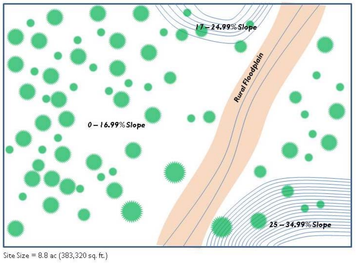
1. Rural Floodplain. The rural floodplain covers approximately 51,000 square feet of the site, and it must be 100 percent protected. The only permitted disturbance to this area includes roadway and utility crossings.
2. Steep Slopes. Table 10-50.90.050.A, Slope Protection Thresholds, indicates that for residential uses, 70 percent of slopes measuring 17 to 24.99 percent must be protected; 80 percent of slopes measuring 25 to 34.99 percent must be protected; and, that no slope protection is required for slopes less than 17 percent.
The following table shows the area that is required to be protected in each of the slope categories by using this simple formula:
Area in each slope category x Protection Threshold (%) = Area to be protected.
|
Slope |
Protection Threshold |
Approximate Area in Sample |
Minimum Area to Be Protected |
|---|---|---|---|
|
0 – 16.99% |
0% |
|
|
|
17 – 24.99% |
70% |
14,000 sq. ft. |
9,800 sq. ft. |
|
25 – 34.99% |
80% |
35,000 sq. ft. |
28,000 sq. ft. |
|
35% and greater |
100% |
0 sq. ft. |
0 sq. ft. |
3. Forest Resources. The sample site is larger than five acres in size, and therefore it may be sampled using a simple technique that distributes one-tenth acre circular sample plots across a minimum of 15 percent of the site (one-tenth acre equals 4,356 square feet). The circular sample plots are distributed across the site on a series of transect lines. The distance between the sample plots along the transect line and the distance between the transect lines should be approximately the same, and will vary based on the size of the site to ensure that a 15 percent representative sample is achieved. The circular plots must be placed no closer than the radius of the plot (i.e., 37 feet) from any property line.
Figure 5.030C
Sample Site Plan – Distribution of One-Tenth Acre Sample Circular Plots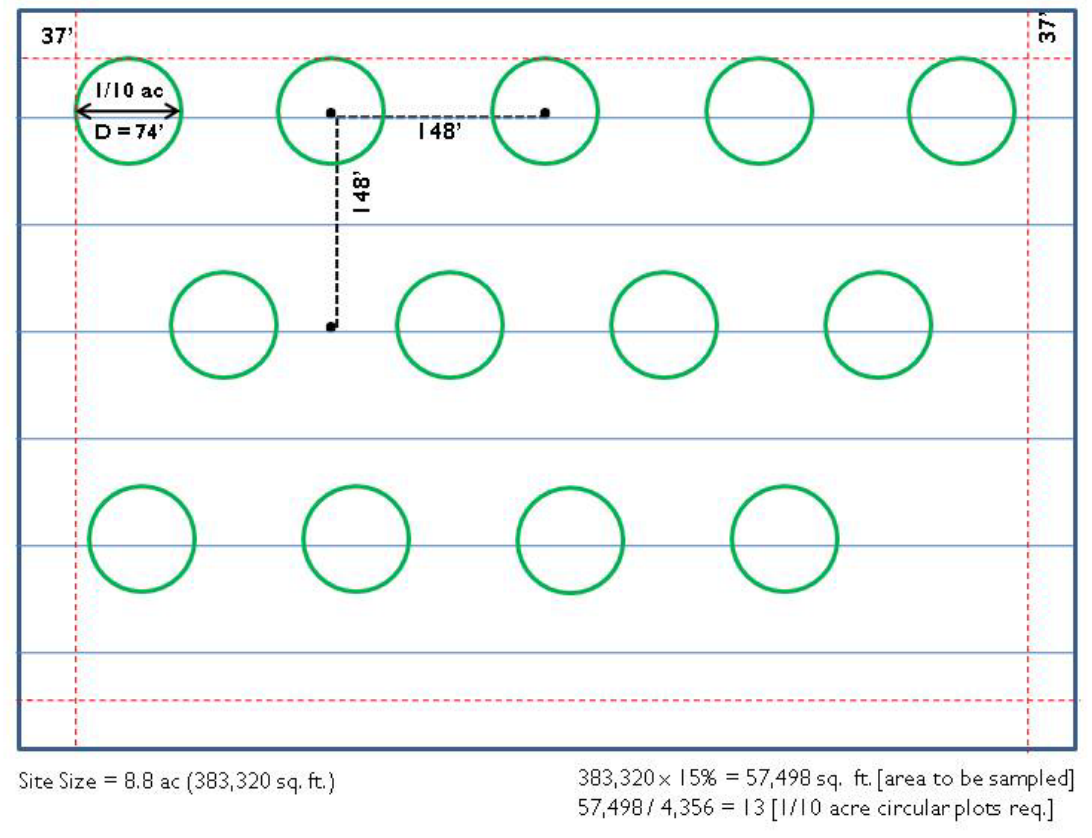
a. As the proposed use of the site is a residential development, the forest resource protection threshold is 50 percent, which is determined from Table 10-50.90.060.A, Forest Resource Protection Thresholds as a Percentage of Site Area.
b. The area of the site is 8.8 acres (383,320 square feet). Therefore, the minimum area to be sampled is: 383,320 (15 percent) equals 57,498 square feet.
c. The number of one-tenth acre circular plots is determined by dividing the minimum area to be sampled by the area of a one-tenth-acre circular sample plot: 57,498/4,356 equals 13.
d. The diameter of a one-tenth-acre circular sample plot is 74 feet. Therefore all sample plots need to be placed a minimum of 37 feet from any property line.
e. The 13 sample plots are distributed across the site such that they are equally spaced from each other along a transect line and between transect lines. In this example the distance between circular plots on separate transect lines is 148 feet (from center), and the distance between circular plots on the same transect line is also 148 feet (from center).
f. As shown on the site plan below, points are assigned to trees based on their diameter at breast height (DBH) measured in inches. Note that if a tree is located only partially within the circular sample plot it is only counted if 50 percent or more of the tree is within the sample plot.
Figure 5.030D
Sample Site Plan – Distribution of Sample Plots Relative to Tree Locations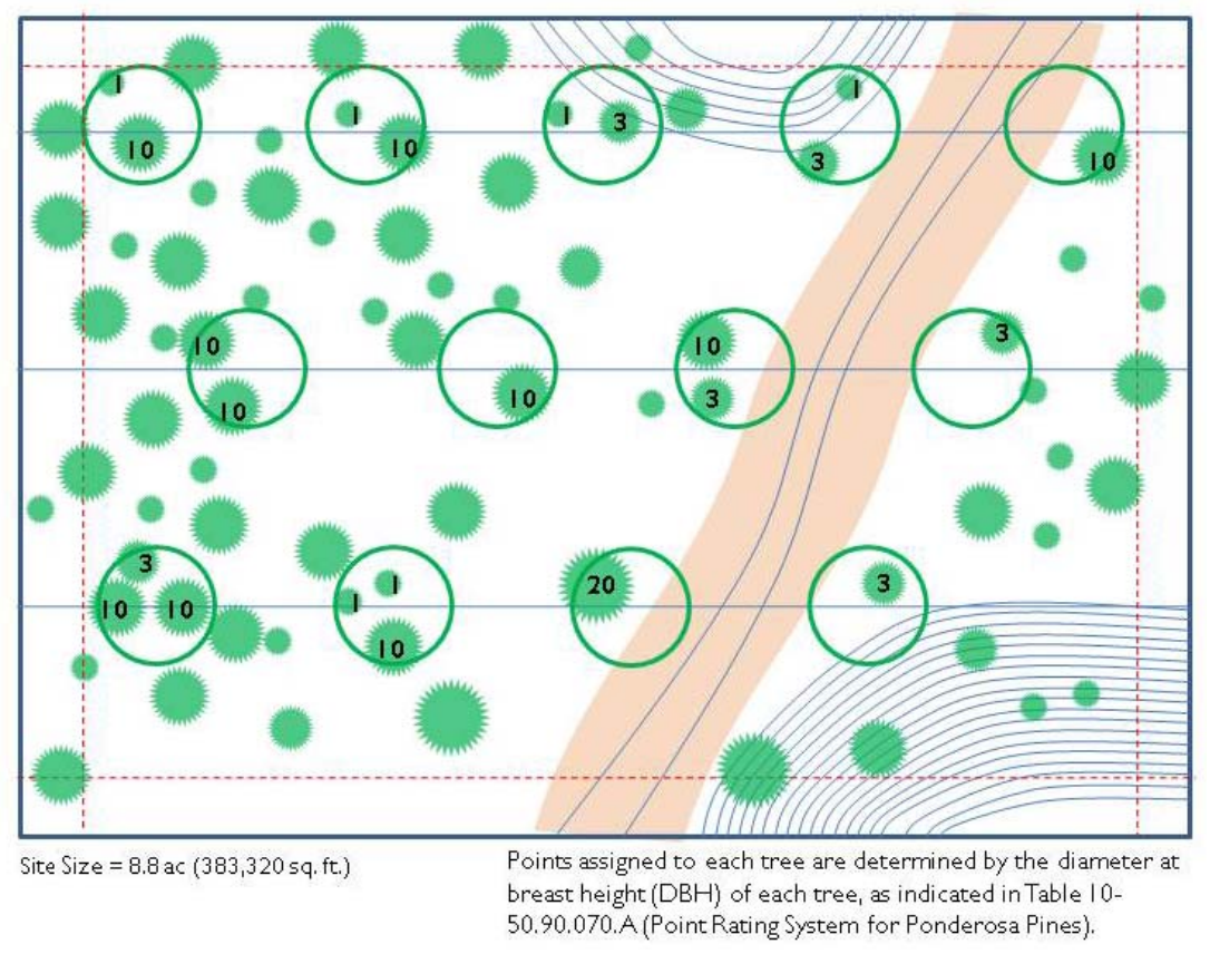
g. The total of forest resource points for all trees within the sample plots can then be calculated using the values provided in Table 10-50.90.070.A, Point Rating System for Ponderosa Pines.
|
Tree Canopy |
DBH in Inches |
Points |
# in Sample |
Total Points |
|---|---|---|---|---|
|
|
8 – 12 |
1 |
6 |
6 |
|
|
13 – 17 |
3 |
6 |
18 |
|
|
18 – 24 |
10 |
10 |
100 |
|
|
25 + |
20 |
1 |
20 |
|
|
|
|
|
144 |


h. As the values in the table above are only for the 15 percent sample area, the total number of forest resource points for the entire site must be calculated:
(Total points from sample x 100) / 15 = Points for entire site, i.e., (144 x 100) / 15 = 960 total points
i. To apply the forest resource protection threshold for the site as a residential use (50%), use the following simple formula:
(Points for entire site) x 50% = Resources (points) to be retained on site, i.e., 960 x 50% = 480
Therefore, a total of 480 forest resource points must be retained on the site. To determine which trees may be removed and which should be preserved, it is important to apply the standards in Section 10-50.90.030(B)(3), Priority for Resource Protection, as this section establishes rules for prioritizing forest resource protection. For example, forest resources located in areas that connect to urban and rural floodplains or that are located in steep slope areas are more important than those located elsewhere on the site.