


Division VI. Resource Management
Chapter 18.300
HILLSIDE PROTECTION
Sections:
18.300.030 Density and intensity criteria.
18.300.040 Hillside development use permit (HDP).
18.300.050 Development standards.
18.300.060 Soils report and peer review.
18.300.080 Application, review authority, review, and hearing.
18.300.010 Purpose.
The purpose of this chapter is to establish regulations to minimize impacts of hillside development and protect views in hillside areas. The intent of these regulations is to ensure that the design of new development complements existing topography so that improvements result in a natural and unobtrusive appearance. These regulations are also established to minimize risk of personal injury, impacts to water quality, and damage to property from landslides, erosion, earth creep, stormwater runoff, and other hazards in and near hillside areas of the city. [Ord. 12-4. DC 2012 § 122-769].
18.300.020 Applicability.
A. The provisions of this chapter apply to any subdivision, new use, or structure (including accessory structures), additions to existing structures that exceed 50 percent of the size of the existing structure, and other development on any parcel with an average slope of 15 percent or greater, hereinafter referred to as “hillside parcels.”
B. Slope is measured by taking the vertical distance, or “rise,” over the horizontal distance, or “run.” The resulting fraction, or percentage, is the “slope” of the land.
C. In the event of a conflict between the provisions of this chapter and other development code regulations, including the provisions of the applicable zoning district, the provisions of this chapter shall apply.
D. The provisions of this chapter do not apply to additions to existing single-family residences when the area of the addition is less than 50 percent of the area of the existing residence and there is no hillside development permit for the existing residence. [Ord. 12-4. DC 2012 § 122-770].
18.300.030 Density and intensity criteria.
A. Maximum Allowed Density.
1. The maximum residential density for any hillside parcel shall be calculated according to the following figure:
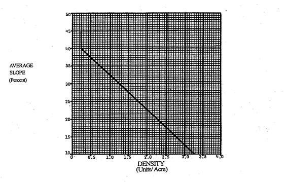
FIGURE 18.300.030 – MAXIMUM ALLOWED DENSITY
2. The maximum intensity or floor area ratio (FAR) for nonresidential development shall be reduced for hillside parcels in compliance with Table 18.300.030.
|
Average Slope of Lot |
Percent Reduction to Maximum FAR |
|---|---|
|
15 percent |
30 percent |
|
16 percent |
29 percent |
|
17 percent |
28 percent |
|
18 percent |
27 percent |
|
19 percent |
26 percent |
|
20 percent |
25 percent |
3. The maximum allowed density or intensity in subsections (A)(1) and (2) of this section may be required to be further reduced by the review authority, if necessary to:
a. Protect the health, safety, or general welfare of persons residing or employed in the vicinity of the site, protect property and improvements in the vicinity, or to protect the general welfare of the city;
b. Protect water quality in downstream creeks or rivers; or
c. Preserve significant views from public open spaces, rights-of-way, or other public places.
4. An exemption from the maximum allowed density or intensity may be approved by the review authority on any hillside parcel meeting all of the following conditions:
a. The average slope is less than 20 percent;
b. The parcel has previously been developed, or the parcel is abutted on all four sides with developed properties, and the proposed density or intensity is consistent with the adjacent development;
c. Open space does not exist on any side of the parcel; and
d. The parcel is less than five acres in size.
5. Any hillside parcel exempted from the maximum allowed density or intensity by subsection (A)(4) of this section shall comply with all of the other provisions in this chapter.
B. Single-Family Residences. Nothing in this chapter shall prohibit the construction and occupancy of a single-family residence on a hillside parcel created pursuant to the Subdivision Map Act and the city’s subdivision ordinance. New development shall be built in compliance with this chapter. [Ord. 12-4. DC 2012 § 122-771].
18.300.040 Hillside development use permit (HDP).
A hillside development use permit (HDP) shall be required for all development as described in Chapter 18.445 CDC on any hillside parcel. [Amended during 2014 recodification; Ord. 12-4. DC 2012 § 122-772].
18.300.050 Development standards.
All hillside development shall comply with the following development standards in addition to the standards for the applicable zoning district.
A. Slope Limits. Land with an average slope of 30 percent or more shall not be developed. Development on land with an average slope of 20 percent or more shall be limited to a single-family dwelling. Encroachment of building envelopes onto slopes exceeding these percentages may be permitted by the review authority only when all of the following findings can be made:
1. It is substantially infeasible to locate the proposed building inside the maximum percent slope area;
2. Where such location would have a substantially less impact on the environment;
3. Where such location is deemed appropriate to facilitate clustered development; and
4. Measures are included that provide adequate mitigation of environmental impacts such as visual, biological, and geotechnical impacts.
B. Treatment of Sloped Areas.
1. All areas with an existing average slope of 30 percent or greater shall be left undisturbed;
2. All areas with an existing average slope of 20 percent or more that are not covered with structures or used for access to the property shall not be paved, and shall only be disturbed as necessary to develop the site;
3. Slopes created or altered by grading shall not exceed 30 percent; and
4. For slopes up to 15 percent, impervious surfaces shall not exceed 40 percent of the gross land area. Slopes that exceed 15 percent shall not have impervious surfaces that exceed 30 percent or less.
C. Protection of Ridgeline Views. The highest point of any structure shall not be located within 100 vertical feet of a ridgeline (i.e., a ground line located at the highest elevation of a connected series of major and minor hills).
D. Subfloor Parking for Nonresidential Buildings. The maximum allowable floor area for nonresidential development may be increased to a maximum of 20 percent when at least 25 percent of the required parking spaces are provided below grade, or in a subfloor, and incorporated into the design of the building. The 20 percent increase in FAR shall be applied to the total floor area calculated after the maximum allowable FARs in Table 18.300.030 are applied. In no case shall a project exceed the FAR or other development standards of the applicable zoning district.
E. Fences. Exterior fencing on hillside parcels shall be limited to wire mesh with wood posts or other similar natural materials that are transparent and do not significantly affect views of the site. Chain link fencing, solid wood, masonry, or other opaque fence/wall materials are prohibited. [Ord. 12-4. DC 2012 § 122-773].
18.300.060 Soils report and peer review.
A. As a part of each application for an HDP, the applicant shall submit a preliminary soils or geotechnical report prepared by a qualified professional, at the applicant’s expense. The study shall include all information and materials required by the city engineer.
B. The report shall be reviewed and approved by the city engineer or by a consulting geotechnical engineer, hired by the city at the applicant’s expense.
C. The applicant shall incorporate all recommendations into the design of the project.
D. This requirement may be waived if the city engineer determines that the project, because of its size, location, or design, will not have a significant impact on the hillside, or that sufficient information already exists and further analysis is not necessary. [Ord. 12-4. DC 2012 § 122-774].
18.300.070 Design criteria.
All HDPs shall comply with the following criteria where applicable:
A. Terrain Alteration. Development shall be designed to fit the terrain rather than altering the terrain to fit the development.
1. Final contours and slopes shall be rounded and shaped to simulate the existing topography, and shall blend with adjacent landforms.
2. Development patterns that require excessive cuts or fill, or form visually protruding horizontal bands, or steeply cut slopes for roads or lots shall be avoided. In particular, wide building pads and terraces interspersed with slopes shall not be created, and ridgelines, knolls, and significant tree masses shall be maintained.
B. View Protection. Views from public or private open space areas, rights-of-way, and other public places shall not be significantly affected, and development shall avoid significant intrusion into views from adjoining up-slope properties.
C. Structure Siting and Design. Site design shall utilize varying setbacks, structure heights, split-level foundations, low retaining walls, and terraces to blend structures into the terrain. Front building setbacks shall be varied and staggered consistent with natural hillside character.
D. Location of Structures. Structures shall be located in the most accessible, least visually prominent, and most geologically stable portion of the site. When feasible, structures shall be located so that they will be screened by existing vegetation, rock outcroppings, or depressions in topography. Buildings and improvements shall be located to save trees and minimize grading. Additional native plant materials shall be added to augment the screening qualities of existing vegetation, where appropriate.
E. Retaining Walls.
1. Tall and/or long retaining walls shall be prohibited. Retaining walls shall be limited to four feet in height, unless otherwise approved due to geological or other physical constraint;
2. Retaining walls shall be stepped with landscaped terraces to reduce the individual height of walls;
3. Materials for retaining walls shall be durable and resistant to rot, structural pests, or other environmental factors. Cast in place concrete or concrete block are the preferred materials; and
4. Access to the site and excavation for walls shall be carefully controlled to minimize disturbance to the hillside and slope face.
F. Exterior Lighting. Lighting for hillside development shall be designed to eliminate direct and off-site glare and the spill of light to surrounding areas. Site and building designs shall incorporate low-intensity exterior lighting. Low ground-level fixtures shall be used rather than fewer, taller light fixtures.
G. Colors and Materials. A harmonious mixture of exterior colors and materials shall be used to blend structures and site improvements with the natural hillside as follows:
1. Darker, flat-toned colors, such as browns, black, greens and terra cotta, are preferred and light or bright colors shall be avoided, including white stucco walls and reflective roofing; and
2. As appropriate, a mix of rough-textured materials, such as stucco, wood, brick, and coarse block shall be used.
H. Building Design. To reduce scale and massing, structures and improvements shall:
1. Be scaled to complement the hillsides and to avoid excessively massive forms that dominate views of the hills;
2. Be compatible with the existing adjacent neighborhood in terms of scale;
3. Be designed to locate windows, balconies, and outdoor living areas with consideration for the privacy of adjacent dwellings and yards, to the maximum extent feasible;
4. Be stepped back to follow the natural contour of the slope, with the height of the tallest vertical plane not exceeding 20 feet measured from grade; and stepping back a minimum of 10 feet at the 20-foot limit. See Figure 18.300.030 (Maximum Allowed Density);
5. Use varying vertical planes and overhangs as a means to create changing shadow lines;
6. The roof pitch shall follow the angle of the site’s slope and roof slopes shall be varied to avoid a monotonous appearance; and
7. Structural underpinnings for decks, additions, or foundation structures shall be integrated into the design of the building and shall not be visible from off site.
I. Street and Driveway Layout. Streets and driveways shall follow the natural contours of the terrain to reduce grading, tree removal, and visual impacts, where possible. The following street and driveway designs may be considered subject to approval by the city engineer and planning division:
1. Cul-de-sacs, split roads, loop roads, and parallel street parking where appropriate to fit the natural topography; and
2. Narrower street sections as identified in CMC 17.20.030 (Subdivision design standards) where appropriate.
J. Lot Configuration. The creation of new lots or the adjustment of lot lines shall:
1. Be practical for improvements, due to steepness of terrain, geologic hazards, or location of watercourses or drainage;
2. Be designed to avoid grading or building within 25 vertical feet of the top five-foot contour of a ridgeline or knoll;
3. Be configured to minimize grading and preserve topographic and geologic features;
4. Take into account natural landforms and vegetation to the greatest extent possible;
5. Be designed to provide residential interior side yard fencing at the top of slope in order to provide privacy and to avoid the double fencing at the top and bottom of a slope; and
6. Accommodate drainage with swales and catch basins rather than V-ditches and benches, and avoid lot-to-lot drainage with property lines at the top of slope areas. [Ord. 12-4. DC 2012 § 122-775].
18.300.080 Application, review authority, review, and hearing.
All hillside development permits shall be processed, reviewed, and approved or disapproved in accordance with the provisions in Chapter 18.445 CDC (Hillside Development Use Permit) and all approvals shall be consistent with the findings in CDC 18.300.090. [Ord. 12-4. DC 2012 § 122-776].
18.300.090 Findings.
The review authority shall approve or conditionally approve a proposed HDP in compliance with Chapter 18.445 CDC upon finding that:
A. The design, scale, massing, height and siting of the project is compatible with the site and consistent with the character and scale of the surrounding developed neighborhood;
B. The design and site layout of the project respects and protects the natural environment to the maximum extent feasible;
C. The site grading is sensitive to the hillside site, minimizes tree removal, and provides safe site access;
D. The project is consistent with the general plan, and meets the development standards of the applicable zoning district and the hillside development and design standards;
E. The project screens development to the extent feasible through clustering and/or avoidance of highly visible hillsides, ridgelines, and knolls; and
F. The project incorporates adequate access, public services, and utilities. [Ord. 12-4. DC 2012 § 122-777].