


Chapter 23.42
OVERLAY/COMBINING DISTRICTS
Sections:
23.42.020 Designation of overlay/combining districts.
23.42.030 Multifamily overlay district.
23.42.040 Flood combining district.
23.42.050 Mobile home park combining district.
23.42.060 Rural commercial combining zone (RUC).
23.42.070 Surface mining combining district.
23.42.080 Business center district sign overlay zone (BCS).
23.42.090 East Franklin overlay district (EF).
23.42.100 East Elk Grove overlay district (EEG).
23.42.110 Calvine Road/Highway 99 overlay district (CR-99).
23.42.010 Purpose.
The overlay/combining zoning districts established by this title supplement the use regulations and/or development standards of the applicable underlying base zone, where important site, neighborhood, or area characteristics require particular attention in project planning. In the event of a conflict between the regulations of the underlying base zoning district and the overlay/combining zoning district, the provisions of the overlay/combining zoning district shall govern. The provisions of this chapter shall apply to all projects located in a designated overlay/combining zoning district. Overlay/combining zoning district(s) shall be designated by a representative symbol on the zoning map along with the base zoning district with which it is combined. [Ord. 6-2019 §3 (Exh. A), eff. 4-26-2019; Ord. 26-2006 §3, eff. 8-11-2006]
23.42.020 Designation of overlay/combining districts.
Overlay zoning district(s) shall be designated by a representative symbol on the zoning map along with the base zoning district with which it is combined. [Ord. 6-2019 §3 (Exh. A), eff. 4-26-2019; Ord. 26-2006 §3, eff. 8-11-2006]
23.42.030 Multifamily overlay district.
A. Purpose and Intent. The purpose of the multifamily overlay zone (MF) is to implement the General Plan by establishing opportunities for multifamily housing in specified locations throughout the City. This overlay zone supplements the allowed uses and development standards of the underlying zoning district. The intent is to allow multifamily development in conjunction with nonresidential uses permitted in the underlying zoning district to which it is applied.
B. Applicability of Multifamily Overlay Zoning (MF) District. The (MF) appearing after a zone abbreviation on the comprehensive zoning map indicates that the property so classified is subject to the provisions of this section in addition to those of the underlying zone.
C. Permitted Density. Multifamily residential uses shall be permitted with a minimum density of 15.1 dwelling units to the acre and a maximum density of forty (40) dwelling units to the acre.
D. Review Procedure. Multifamily residential development shall require the approval of a district development plan, pursuant to EGMC Section 23.16.080(B)(6). Appropriate development standards for the proposed development shall be set as part of the district development plan review process.
E. Design Review Required. In addition to the provisions of subsection (D) of this section, all development shall comply with the provisions of EGMC Section 23.16.080 (Design review) for design review approval prior to building permit issuance.
F. Accessory Dwelling Units. Accessory dwelling units are also permitted in the multifamily overlay zoning district pursuant to the provisions of EGMC Chapter 23.90 (Accessory Dwelling Units). [Ord. 28-2019 §3 (Exh. A), eff. 2-7-2020; Ord. 6-2019 §3 (Exh. A), eff. 4-26-2019; Ord. 24-2015 §11 (Exh. I), eff. 2-12-2016; Ord. 26-2006 §3, eff. 8-11-2006]
23.42.040 Flood combining district.
A. Purpose. The flood (F) combining district as shown on the zoning map is intended to comprise all known land covered by rivers, creeks, and streams and land subject to flooding within the City. For certain regulations and standards, the district is subdivided into three (3) components: F100, corresponding to the one hundred (100) year floodplain, F200, corresponding to the two hundred (200) year floodplain, and F100/200, corresponding to the area overlapped by both the one hundred (100) year and two hundred (200) year floodplain. In adopting the regulations, the City recognizes that:
1. The promotion of the orderly development and beneficial use of lands subject to recurrent flooding is necessary if the potential property damage which results from improper development is to be minimized.
2. There is a need to protect current and future occupants of land subject to flooding from the physical damage of flooding.
3. The health, general welfare, and safety of the public of the City as a whole require that lands subject to flooding be strictly regulated as to the uses permitted on the land and the amount of open space which separates buildings and structures.
4. Inundation frequently causes extensive property damage.
5. Strict regulation of flood lands is necessary to protect prospective buyers of land from deception as to the utility of the land within the flood zones.
B. Restrictions. No building, structure, vehicle, sign, or area in any underlying zone with which the F district is combined shall be used, nor shall any building, structure, sign, or vehicle be erected, altered, moved, enlarged, or stored in any base zone with which the F district is combined, except as hereinafter specifically provided in this chapter or elsewhere in this title; nor shall any area, building, structure, vehicle, or sign be used in any manner so as to create problems adverse to the public health, safety, or general welfare, or so as to constitute a public nuisance. Any building, structure, vehicle, sign, or lot, or the use of any building, structure, vehicle, or lot, in any base zone with which the F district is combined shall be regulated and governed by the provisions of this section, the regulations and provisions applicable to such base zone, and other applicable regulations of this title. To the extent of any conflict between the provisions of the base zone with which the F district is combined, the stricter provisions shall prevail.
C. Elevations. No building or structure designed for human habitation shall hereafter be erected, altered, moved, or enlarged with a first (1st) floor elevation lower than required by EGMC Chapter 16.50 (Flood Damage Prevention).
D. Development Standards. Except as provided below, development in the F district shall be consistent with the underlying base zoning district.
1. All new development and improvements to existing structures shall comply with the provisions identified in Table 23.42.040-1 below:
|
Requirement |
Flood Area |
||
|---|---|---|---|
|
F100 |
F100/200 |
F200 |
|
|
Comply with provisions of EGMC Chapter 16.50 |
Required |
Required |
Not Required |
|
Determine whether flood depth is >3ft; if so, make findings required in subsection (E) of this section prior to project approval |
Not Required |
Required |
Required |
2. Health care facilities and government facilities shall be prohibited from being built in the F district. The City Council may approve exceptions to this if it determines that the operations of the proposed facility would be substantially compromised in an alternative location.
3. Any new development that occurs in the F district shall have adequate setbacks from flood control levees consistent with local, regional, State, and Federal design and management standards.
4. Any new development that occurs in the F district shall not have roadways on levees as a primary access point.
E. Findings. No development or physical changes requiring a development permit required by this title shall be allowed within the two hundred (200) year floodplain unless it has first met one (1) or more of these findings; these findings shall be made by the designated approving authority, as specified by EGMC Chapter 23.16:
1. The project has an urban level of flood protection from flood management facilities that is not reflected in the most recent map of the two hundred (200) year floodplain;
2. Conditions imposed on the project will provide for an urban level of flood protection;
3. Adequate progress has been made toward construction of a flood protection system to provide an urban level of flood protection for the project, as indicated by the Central Valley Flood Protection Board for State projects, or by the Floodplain Administrator for local projects; or
4. The project is a site improvement that would not result in the development of a new habitable structure, and would not increase risk of damage to neighboring development or alter the conveyance area of a watercourse in the case of a flood. Improvements that qualify for this exemption include, but are not limited to, the replacement or repair of a damaged or destroyed habitable structure with substantially the same building footprint area; interior repairs or remodels to existing structures; new nonhabitable structures or repairs or remodels to nonhabitable structures including but not limited to landscape features, detached garages, and pools and spas. [Ord. 28-2019 §3 (Exh,. A), eff. 2-7-2020; Ord. 6-2019 §3 (Exh. A), eff. 4-26-2019; Ord. 15-2016 §3 (Exh. A), eff. 9-23-2016; Ord. 8-2011 §19(A), eff. 6-24-2011; Ord. 26-2006 §3, eff. 8-11-2006]
23.42.050 Mobile home park combining district.
A. Purpose. The mobile home park (MHP) combining district is designed to provide for the development of mobile home parks, as defined in Division VI, Zoning Definitions A – Z, of this title. When combined with the underlying zone, it will provide opportunity for a variety of mobile home park environments that are compatible with the communities in which they are placed. In adopting these regulations, the City recognizes that:
1. There is a need to afford present and future City residents with increased options for residential living environments.
2. Mobile home parks are a potential means for affordable housing.
3. Mobile home park densities should be consistent with densities in surrounding areas.
4. There should be opportunities for design flexibility to permit mobile home park developments to be responsive to different site conditions, community plan considerations, potential markets, and sizes of mobile homes.
B. Applicability. The MHP district may be combined with any residential underlying zone and is required for the development of all new mobile home park projects.
C. Allowed Uses and Permit Requirements. Table 23.42-1 identifies allowed uses for the MHP combining district subject to compliance with EGMC Chapter 23.26, Use Classification System, and all other provisions of this title. Descriptions of the land use listings can be found in EGMC Section 23.26.050, Description of land use classifications. Note: The far right column in the table (“Specific Use Regulations”) includes the chapter number(s) for regulations that apply to the particular use listed, in addition to the other general standards of this title.
D. Design review is required for all new mobile home parks pursuant to EGMC Section 23.16.080, Design review. In addition to the standard submittal requirements, design review applications for mobile home parks shall show individual site conditions, reflect the type of market to be served, and be adaptable to the trends in design of mobile homes. Site planning should utilize terrain, existing trees, shrubs and rock formations and ought to reflect the recommendations enumerated below:
1. Amenities. Include provision for facilities and amenities appropriate to the needs of the occupants.
2. Arrangement of Structures and Facilities. The site, including mobile home stands, patios, structures, and all improvements, should be harmoniously and efficiently organized in relation to topography, the shape of the plot, and the shape, size, and position of structures and common facilities. (Attention should be given to use, appearance, and livability.)
|
P = Use Permitted |
CUP = Conditional Use Permit Required |
N = Not Permitted |
|---|---|---|
|
Land Use |
MHP District |
Specific Use Regulations |
|
Residential Uses |
||
|
Caretaker housing |
P |
|
|
Child care center |
CUP |
|
|
Dwelling, single-family |
P |
|
|
Dwelling, two-family |
P |
|
|
Mobile home park |
CUP |
|
|
Supportive housing |
P |
|
|
Transitional housing |
P |
|
|
Recreation, Education, and Public Assembly Uses |
||
|
Assembly uses |
CUP1 |
|
|
Community garden |
P1 |
|
|
Golf courses/clubhouse |
CUP1 |
|
|
Recreational vehicle parks |
CUP |
|
|
Resource protection and restoration |
P |
|
|
Resource-related recreation |
P |
|
|
Utility, Transportation, and Communication Uses |
||
|
Bus and transit shelters |
P |
|
|
Telecommunications facility |
CUP |
EGMC Chapter 23.94 |
|
Utility facility and infrastructure |
P |
|
|
Retail, Service, and Office Uses |
||
|
Offices, accessory |
CUP1 |
|
|
Restaurants |
CUP1 |
|
|
Industrial, Manufacturing, and Processing Uses |
||
|
Recycling facility – Collection, small |
P |
|
Notes:
1. Permitted as part of the mobile home park development available to residents and guests.
3. Adaption to Site Assets. The mobile home unit should be fitted to the terrain with a minimum disturbance of the land. Existing trees, rock formations, and other natural site features should be preserved if practical. Favorable views or outlooks ought to be emphasized by the plan.
4. Protection from Adverse Influences. Adequate protection should be provided against any undesirable off-site views or any adverse influence (such as heavy commercial or industrial use, heavy traffic, or brightly lighted activities) from adjoining streets and areas.
5. Site Plan. The site plan shall provide for a desirable residential environment for mobile homes which is an asset to the community in which it is located. Innovation and imaginative design shall be encouraged, and monotony avoided.
6. Suitability of Site Improvements. All site improvements shall be appropriate to the type of development and durable under the use and maintenance contemplated.
E. Development Standards. The development standards listed below are intended to assist property owners and project designers in understanding the City’s minimum requirements and expectations for mobile home park development. The designated approving authority will review any relevant development applications against these standards to determine compliance with applicable zoning regulations. Additional standards are listed below the table.
|
Development Standard |
MHP |
|---|---|
|
Minimum Lot Area |
|
|
Mobile home park |
5 acres |
|
Individual mobile home site1 |
2,940 sf/site |
|
Maximum density |
Consistent with underlying zone2 |
|
Lot coverage (individual sites) |
75% |
|
Minimum park area |
5 acres (net) |
|
Front yard setback (landscaped) |
20 ft. |
|
Interior yard setback (landscaped) |
10 ft. |
|
Mobile Home Site Setback Distance |
|
|
Internal street setback distance |
5 ft. |
|
Distance between mobile home structures |
10 ft.3, 4 |
|
Distance between mobile homes and interior lot lines or property lines |
3 ft. |
|
Distance between mobile homes and detached accessory structures |
10 ft.4 |
|
Minimum width of street frontage |
60 ft. |
|
Water supply |
Public water supply5 |
|
Sanitation facility |
Public sanitary sewerage |
|
Fences and walls |
Refer to EGMC Chapter 23.52 |
|
Landscaping |
Refer to EGMC Chapter 23.54 |
|
Lighting |
Refer to EGMC Chapter 23.56 |
|
Parking |
Refer to EGMC Chapter 23.58 |
|
Performance standards |
Refer to EGMC Chapter 23.60 |
|
Signs |
Refer to EGMC Chapter 23.62 |
Notes:
1. All lots shall be numbered, clearly defined and marked at all corners with permanent markers.
2. The City may permit increased densities up to fifty (50%) percent over the maximum permitted by the underlying zone when it finds that at least fifteen (15%) percent of the lots are designed exclusively for the placement of single-wide mobile homes.
3. Distance is side to side. If side to rear, minimum setback is eight (8' 0") feet. If rear to rear, minimum setback is six (6' 0") feet.
4. Overhangs may encroach into required setback as long as a minimum of six (6' 0") feet is maintained between all portions of the structures.
5. On- and off-site fire hydrants and fire protection facilities shall be installed as specified in the development plan and shall be of a type approved by the chief of the local fire protection district.
F. Management. Every mobile home park community shall be properly managed to ensure maintenance of common facilities and to ensure individual home sites are developed and maintained in accordance with recorded rules and regulations for the park.
G. Site Use and Improvements. Each mobile home shall be located on an approved mobile home site and all mobile home sites shall be designed to accommodate independent mobile homes. No mobile home site shall be used as the location for more than one (1) mobile home or trailer. Each mobile home parking area shall be provided with a support structure that complies with both State- and City-adopted building codes for proper drainage and sanitation. Each mobile home shall be skirted.
H. Parking. Each mobile home site shall have at least two improved parking spaces of a minimum size of ten (10' 0") feet by twenty (20' 0") feet. One such space can be provided off the mobile home site itself. Additionally, a minimum of one guest parking space shall be provided for every eight (8) sites in the park in accordance with the provisions of EGMC Chapter 23.58, Parking. Required tenant and guest spaces shall not be used for storage of boats or recreational vehicles. Street parking is prohibited, unless designated spaces are designed and constructed with authorization from the City’s Fire Marshal.
I. Outdoor Living Area. Private outdoor living and service space shall be provided on each lot for each mobile home and be located for privacy and convenience to the occupant. The minimum area shall be at least three hundred (300 ft2) square feet, with a minimum width of fifteen (15' 0") feet.
J. Accessory Storage Cabinet Structures. Each mobile home site shall be permitted a maximum of two accessory storage cabinet structures, with a maximum combined area of one hundred (100 ft2) square feet for storage purposes. Accessory structures shall not be located in the front yard of any site and shall be set back a minimum of six (6' 0") feet from the mobile home structure, with the exception that noncombustible structures need not be set back from the lot lines or mobile home structure.
K. Walls and Fences. Along the common boundary between a mobile home park and any single-family or two-family zoning district or use, a minimum six (6' 0") foot high solid masonry wall shall be constructed to serve as a visual screen and buffer between uses. Screening fences not less than six (6' 0") feet in height shall be installed and maintained around interior laundry yards, refuse collection points for common areas, and playground areas. Neighbor fences between home sites shall not exceed four (4' 0") feet in height.
L. Roadways. Mobile home parks shall be developed with a minimum thirty-six (36' 0") foot wide driveway entrance, a minimum thirty (30' 0") foot cul-de-sac radius, and streets shall be a minimum thirty (30' 0") foot width with no parking on either side, a minimum thirty-three (33' 0") feet wide where parking is allowed on one side and forty-two (42' 0") feet wide where parking is allowed on both sides. Individual mobile home sites shall have direct access from an interior street and not from a public street outside the park. Mobile home park roadways and driveways shall be paved and maintained in good repair in accordance with City standards. All such roadways and driveways shall be surfaced and graded in such a manner that the drainage for the mobile home park shall drain to a centrally located drain or system of drains which shall be connected to the nearest storm sewer or other such system.
M. Landscaping. All required minimum setback areas around the perimeter of the park shall be permanently landscaped and maintained with ground cover, trees, and shrubs.
N. Utilities. Unless otherwise specifically authorized by the designated approving authority, all utilities providing service to the park shall be placed underground. Equipment appurtenant to the underground facilities (e.g., transformers, meter cabinets) may be placed above ground.
O. Occupancy/Utility Hook-Up Inspection. Prior to change of any unit or initial unit occupancy, the City shall inspect utility hook-ups and verify compliance with required setbacks. Fees for inspection shall be established by resolution of the City Council.
P. Lighting. Mobile home park illumination shall comply with the minimum level of illumination required by State law for security purposes and be consistent with EGMC Chapter 23.56, Lighting. Fixtures shall be directed downward and light shall not spill onto abutting property outside of the mobile home park community.
Q. Recreation Area. A recreation area shall be provided and maintained on site at a rate of two hundred (200 ft2) square feet for each mobile home unit within the park. Recreation areas include recreation rooms, landscaped buffer zones, walkways, playgrounds, and other similar amenities. [Ord. 16-2021 §4 (Exh. B), eff. 9-10-2021; Ord. 8-2011 §§19(B), (C), (D), eff. 6-24-2011; Ord. 26-2006 §3, eff. 8-11-2006]
23.42.060 Rural commercial combining zone (RUC).
A. Purpose and Intent. The purpose of the rural commercial (RUC) combining zone is to preserve and maintain the rural character of the City’s rural commercial area by establishing unique allowed use and development standards applicable for those areas of the City with the RUC combining zone designation. This combining zone is intended to allow a full range of businesses and services that support surrounding agricultural and agricultural-residential uses and to maintain patterns in keeping with the historical context of the area.
B. Applicability. The rural commercial (RUC) combining zone as shown on the City’s zoning map includes all parcels generally located at or near the intersection of Grant Line Road and Wilton Road that are zoned as either general commercial (GC), limited commercial (LC), or industrial (LI), as well as all parcels at or near that intersection that have a General Plan designation of commercial or light industry, as illustrated in Figure 23.42-1. The (RUC) appearing after a zone abbreviation on the City’s adopted zoning maps indicates that the property so classified is subject to the provisions of this section in addition to those of the underlying zone.
Figure 23.42-1
Rural Commercial Combining Zone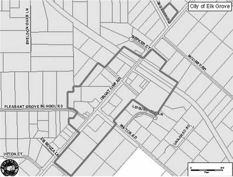
C. Definitions.
1. “Rural residential area” means that area east of Elk Grove-Florin Road that is designated rural residential on the City’s General Plan land use map, adopted on November 19, 2003.
D. Allowed Uses. In addition to the allowed land uses of the underlying zoning district, the following agricultural uses are allowed by right in compliance with the maximum building footprint. Agricultural structures between fifteen thousand one (15,001 ft2) and twenty thousand (20,000 ft2) square feet may be allowed subject to approval of a conditional use permit.
1. All uses defined as “agricultural” in Table 23.27-1, Allowed Uses and Required Entitlements for Base Zoning Districts;
2. Agricultural tourism;
3. Animal hospital and veterinary office;
4. Farm equipment – rental and incidental storage;
5. Hay, seed and grain store;
6. Nursery or greenhouse.
E. Maximum Building Footprint. The maximum gross square footage of any single structure in the RUC combining zone shall not exceed the limitations listed below. The intent is to limit the scale of individual buildings to ensure compatibility with the rural residential community. It is not intended to diminish the developable square footage per parcel or to limit the list of permissible land uses established by each district in this title.
1. Generally. Except as provided below, no single structure shall exceed a gross square footage of fifteen thousand (15,000 ft2) square feet.
2. Neighborhood Market. Any structure that contains a neighborhood market, as defined in EGMC Section 23.26.050 (Description of land use classifications), may have a gross square footage not to exceed twenty-five thousand (25,000 ft2) square feet, regardless of whether the structure includes one (1) or multiple tenants.
3. Agricultural Structures. Agricultural structures, including large-animal veterinary clinics, may have a gross square footage not to exceed twenty thousand (20,000 ft2) square feet upon approval of a conditional use permit by the designated approving authority.
F. Drive-Through Uses.
1. Uses Restricted. Drive-through uses in the RUC combining zone shall be limited to the following:
a. Services uses, including, but not limited to, banks/ATMs/financial institutions, pharmacies, and dry cleaning.
b. Restaurants, upon approval of a conditional use permit, where fifty-one (51%) percent or more of the sales (receipts) are beverages.
2. Development Standards. All allowed drive-through uses in the RUC combining zone shall comply with the standards listed in EGMC Chapter 23.78 (Drive-In and Drive-Through Facility) and with the following additional standards:
a. Hours of Operation. Hours of operation for the drive-up/drive-through service shall be limited from 7:00 a.m. to 10:00 p.m. daily.
b. Noise. Any drive-through speaker system shall be located and operated in a manner such that the speaker system is not audible above daytime ambient noise levels at adjoining residential property lines.
c. Orientation. Drive-through window(s) shall be designed and oriented to minimize visual, noise, traffic, and air quality impacts on the adjoining residential properties.
G. Design Review. New development and qualifying modifications/expansions to existing development is subject to the supplemental design guidelines for the Old Town Sheldon Area adopted by City Council resolution. [Ord. 16-2021 §4 (Exh. B), eff. 9-10-2021; Ord. 22-2014 §3 (Exh. A), eff. 10-10-2014; Ord. 8-2011 §19(E), eff. 6-24-2011; Ord. 26-2006 §3, eff. 8-11-2006]
23.42.070 Surface mining combining district.
The City of Elk Grove (hereinafter “City”) recognizes that the extraction of minerals is essential to the continued economic well-being of the City and to the needs of society and that the reclamation of mined lands is necessary to prevent or minimize adverse effects on the environment and to protect the public health and safety. The City also realizes that surface mining takes place in diverse areas where the geologic, topographic, climatic, biological, and social conditions are significantly different and the reclamation operations and the specifications therefor may vary accordingly.
A. Purpose. The purpose and intent of this chapter is to ensure the continued availability of important mineral resources, while regulating surface mining operations as required by California’s Surface Mining and Reclamation Act of 1975 (Section 2710 et seq. of the Public Resources Code), as amended, hereinafter referred to as “SMARA,” Section 2207 of the Public Resources Code (relating to annual reporting requirements), and State Mining and Geology Board regulations (hereinafter referred to as “State regulations”) for surface mining and reclamation practice (Title 14, Division Two, Chapter Eight, Subchapter One, Section 3500 et seq. of the California Code of Regulations (CCR)), to ensure that:
1. Adverse environmental effects are prevented or minimized and that mined lands are reclaimed to a usable condition that is readily adaptable for alternative land uses.
2. The production and conservation of minerals are encouraged, while giving consideration to values relating to recreation, watershed, wildlife, range and forage, and aesthetic enjoyment.
3. Residual hazards to the public health and safety are eliminated.
B. Definitions. The definitions set forth in this section shall govern the construction of this chapter.
1. “Area of regional significance” means an area designated by the State Mining and Geology Board which is known to contain a deposit of minerals the extraction of which is judged to be of prime importance in meeting future needs for minerals in a particular region of the State within which the minerals are located and which, if prematurely developed for alternate incompatible land uses, could result in the premature loss of minerals that are of more than local significance.
2. “Area of Statewide significance” means an area designated by the Board which is known to contain a deposit of minerals the extraction of which is judged to be of prime importance in meeting future needs for minerals in the State and which, if prematurely developed for alternate incompatible land uses, could result in the permanent loss of minerals that are of more than local or regional significance.
3. “Borrow pits” means excavations created by the surface mining of rock, unconsolidated geologic deposits or soil to provide material (borrow) for fill elsewhere.
4. “Board” means the State Mining and Geology Board.
5. “Compatible land uses” means land uses inherently compatible with mining and/or that require a minimum public or private investment in structures, land improvements, and which may allow mining because of the relative economic value of the land and its improvements. Examples of such uses may include, but shall not be limited to, very low density residential, geographically extensive but low impact industrial, recreational, agricultural, silvicultural, grazing, and open space.
6. “Haul road” means a road along which material is transported from the area of excavation to the processing plant or stockpile area of the surface mining operation.
7. “Idle” means surface mining operations curtailed for a period of one year or more, by more than 90 percent of the operation’s previous maximum annual mineral production, with the intent to resume those surface mining operations at a future date.
8. “Incompatible land uses” means land uses inherently incompatible with mining and/or that require public or private investment in structures, land improvements, and landscaping and that may prevent mining because of the greater economic value of the land and its improvements. Examples of such uses may include, but shall not be limited to, high density residential, low density residential with high unit value, public facilities, geographically limited but impact-intensive industrial, and commercial.
9. “Mined lands” means the surface, subsurface, and ground water of an area in which surface mining operations will be, are being, or have been conducted, including private ways and roads appurtenant to any such area, land excavations, workings, mining waste, and areas in which structures, facilities, equipment, machines, tools, or other materials or property which result from, or are used in, surface mining operations are located.
10. “Mineral” means any naturally occurring chemical element or compound, or group of elements and compounds, formed from inorganic processes and organic substances, including, but not limited to, coal, peat, and bituminous rock, but excluding geothermal resources, natural gas, and petroleum.
11. “Operator” means any person who is engaged in surface mining operations, or who contracts with others to conduct operations on his/her behalf, except a person who is engaged in surface mining operations as an employee with wages as his/her sole compensation.
12. “Reclamation” means the combined process of land treatment that maximizes post-mining land uses and minimizes water degradation, air pollution, damage to aquatic or wildlife habitat, flooding, erosion, and other adverse effects from surface mining operations, including adverse surface effects incidental to underground mines, so that mined lands are reclaimed as rapidly as reasonably feasible to a usable condition which is readily adaptable for alternate land uses and creates no danger to public health or safety. The process may extend to affected lands surrounding mined lands, and may require backfilling, grading, resoiling, revegetation, soil compaction, stabilization, or other measures.
13. “Stream bed skimming” means excavation of sand and gravel from stream bed deposits above the mean summer water level or stream bottom, whichever is higher.
14. “Surface mining operation” means all of, or any part of, the process involved in the mining of minerals on mined lands by removing overburden and mining directly from the mineral deposits, open-pit mining of minerals naturally exposed, mining by the auger method, dredging and quarrying, or surface work incident to an underground mine. Surface mining operations include, but are not limited to, in-place distillation or retorting or leaching, the production and disposal of mining waste, prospecting and exploratory activities, borrow pitting, streambed skimming, and segregation and stockpiling of mined materials (and recovery of same).
C. Incorporation by Reference. The provisions of SMARA (Section 2710 et seq. of the Public Resources Code (PRC)), Section 2207 of the PRC, and State regulations, Section 3500 et seq. of the CCR, as those provisions and regulations may be amended from time to time, are made a part of this chapter by reference with the same force and effect as if the provisions therein were specifically and fully set out herein, excepting that when the provisions of this chapter are more restrictive than correlative State provisions, this chapter shall prevail.
D. Scope. Except as provided in this chapter, no person shall conduct surface mining operations unless a permit, reclamation plan, and financial assurances for reclamation have first been approved by the City. Any applicable exemption from this requirement does not automatically exempt a project or activity from the application of other regulations, ordinances or policies of the City, including, but not limited to, the application of CEQA, the requirement of site approvals or other permits, the payment of development impact fees, or the imposition of other dedications and exactions as may be permitted under the law. The provisions of this chapter shall apply to all lands within the City, public and private.
This chapter shall not apply to the following activities, subject to the above-referenced exceptions:
1. Excavations or grading related to agricultural activities or on-site construction or for the purpose of restoring land following a flood or natural disaster.
2. On-site excavation and on-site earthmoving activities which are an integral and necessary part of a construction project that are undertaken to prepare a site for construction of structures, landscaping, or other land improvements, including the related excavation, grading, compaction, and the creation of fills, road cuts, and embankments, whether or not surplus materials are exported from the site, subject to all of the following conditions:
a. All required permits for the construction, landscaping, or related land improvements have been approved by a public agency in accordance with applicable provisions of State law and locally adopted plans and ordinances, including, but not limited to, the California Environmental Quality Act (“CEQA,” Division 13, Section 21000 et seq. of the Public Resources Code);
b. The City’s approval of the construction project included consideration of the on-site excavation and on-site earthmoving activities pursuant to CEQA;
c. The approved construction project is consistent with the General Plan or zoning of the site; and
d. Surplus materials shall not be exported from the site unless and until actual construction work has commenced and shall cease if it is determined that construction activities have terminated, have been indefinitely suspended, or are no longer being actively pursued.
3. Operation of a plant site used for mineral processing, including associated on-site structures, equipment, machines, tools, or other materials, including the on-site stockpiling and on-site recovery of mined materials, subject to all of the following conditions:
a. The plant site is located on lands designated for industrial or commercial uses in the City’s General Plan;
b. The plant site is located on lands zoned industrial or commercial, or are contained within a zoning category intended exclusively for industrial activities by the City;
c. None of the minerals being processed are being extracted on site; and
d. All reclamation work has been completed pursuant to the approved reclamation plan for any mineral extraction activities that occurred on site after January 1, 1976.
4. Prospecting for, or the extraction of, minerals for commercial purposes and removal of overburden in total amounts of less than 1,000 cubic yards in any one location of one acre or less.
5. Surface mining operations that are required by Federal law in order to protect a mining claim, if those operations are conducted solely for that purpose.
6. Any other surface mining operations that the State Mining and Geology Board determines to be of an infrequent nature and which involve only minor surface disturbances.
7. Emergency excavations or grading conducted by the Department of Water Resources or the Reclamation Board for the purpose of averting, alleviating, repairing, or restoring damage to property due to imminent or recent floods, disasters, or other emergencies.
8. Road construction and maintenance for timber or forest operations if the land is owned by the same person or entity, and if the excavation is conducted adjacent to timber or forest operation roads. This exemption is only available if slope stability and erosion are controlled in accordance with Board regulations and, upon closure of the site, the person closing the site implements, where necessary, revegetation measures and postclosure uses in consultation with the Department of Forestry and Fire Protection. This exemption does not apply to on-site excavation and grading that occurs within 100 feet of a Class One watercourse or 75 feet of a Class Two watercourse, or to excavations for materials that are, or have been, sold for commercial purposes.
9. Excavations, grading, or other earthmoving activities in an oil or gas field that are integral to, and necessary for, ongoing operations for the extraction of oil or gas that comply with all of the following conditions:
a. The operations are being conducted in accordance with Division Three (commencing with Section 3000);
b. The operations are consistent with the City’s General Plan and the zoning applicable to the site;
c. The earthmoving activities are within oil or gas field properties under a common owner or operator; and
d. No excavated materials are sold for commercial purposes.
E. Vested Rights. No person who obtained a vested right to conduct surface mining operations prior to January 1, 1976, shall be required to secure a permit to mine, so long as the vested right continues and as long as no substantial changes have been made in the operation except in accordance with SMARA, State regulations, and this chapter. Where a person with vested rights has continued surface mining operations in the same area subsequent to January 1, 1976, he shall obtain City approval of a reclamation plan covering the mined lands disturbed by such subsequent surface mining. In those cases where an overlap exists (in the horizontal and/or vertical sense) between pre- and post-Act mining, the reclamation plan shall call for reclamation proportional to that disturbance caused by the mining after the effective date of the Act (January 1, 1976).
All other requirements of State law and this chapter shall apply to vested mining operations.
F. Process.
1. Applications for a site approval or reclamation plan for surface mining or land reclamation projects shall be made on forms provided by the Development Services Department. Said application shall be filed in accord with this chapter and procedures to be established by the Development Services Director. The forms for reclamation plan applications shall require, at a minimum, each of the elements required by SMARA (Sections 2772 through 2773 of the PRC) and State regulations, and any other requirements deemed necessary to facilitate an expeditious and fair evaluation of the proposed reclamation plan, to be established at the discretion of the Development Services Director. As many copies of the site approval application as may be required by the Development Services Director shall be submitted to the Development Services Department.
2. As many copies of a reclamation plan application as may be required shall be submitted in conjunction with all applications for site approvals for surface mining operations. For surface mining operations that are exempt from a site approval pursuant to this chapter, the reclamation plan application shall include information concerning the mining operation that is required for processing the reclamation plan. All documentation for the reclamation plan shall be submitted to the City at one (1) time.
3. Applications shall include all required environmental review forms and information prescribed by the Development Services Director.
4. Upon completion of the environmental review procedure and filing of all documents required by the Development Services Director, consideration of the site approval or reclamation plan for the proposed or existing surface mine shall be completed pursuant to this section at a public hearing before the Planning Commission, and pursuant to Section 2774 of the Public Resources Code.
5. The reclamation plan shall be applicable to a specific property or properties and shall be based upon the character of the surrounding area and such characteristics of the property as the type of overburden, vegetation, soil stability, topography, geology, climate, stream characteristics and principal mineral commodities.
6. All reclamation plans shall contain, at a minimum, the following information and documents:
a. The estimated time schedule for the beginning and completion of reclamation activities. If the mining operation is to be accomplished in phases, the time schedule shall indicate the estimated beginning and completion of reclamation activities for each phase;
b. An estimate of the cost of completion of reclamation activities, computed at current cost at the time proposed in the time schedule submitted for completion of the reclamation plan;
c. A description of the existing vegetation at and surrounding the site;
d. A general description of the geology of the surrounding area and a detailed description of the geology at the reclamation site;
e. A description of the proposed use or potential uses of land after reclamation, and evidence that all owners of a possessory interest in the land have been notified of the proposed use or potential uses;
f. A description of the manner in which reclamation, adequate for the proposed use or potential uses, will be accomplished, including:
i. The manner in which mining wastes and related contaminants will be controlled and disposed of;
ii. The manner in which affected streambed channels and stream banks will be rehabilitated to a condition minimizing erosion and sedimentation;
g. An assessment of the effect of implementation of the reclamation plan on future mining in the area;
h. A statement by the applicant that he accepts responsibility for all completed reclamation work for a period of two (2) years or such greater period as deemed necessary by the Planning Commission to assure the permanency of all features of the reclamation plan. This subsection shall not apply to normal maintenance and repairs unrelated to the reclamation work on public facilities where dedicated to and accepted by the City of Elk Grove;
i. Such other information as the Development Services Department may require;
j. The Development Services Department may waive the filing of one (1) or more of the above items where it is determined unnecessary to process the application subject to the provisions of this chapter.
7. Additional information may be required per a Development Services Department form. Where reclamation plans are not filed as a part of a surface mining permit, such plan shall be accompanied by an application for separate reclamation plan approval which contains the following information:
a. The names and addresses of the applicant and the mining operator, if different, and of any persons designated by the applicant as his agents for service of process; and
b. The names and addresses of all persons owning a possessory and/or mineral interest in any or all of the property to be used for mining operations.
8. The Development Services Department may deny, without a public hearing, an application for a reclamation plan if such application or plan does not contain the information required in subsection (F)(6) of this section. The Development Services Department may permit the applicant to amend such application.
9. Within ten (10) days of acceptance of an application as complete for a site approval for surface mining operations and/or a reclamation plan, the Development Services Department shall notify the State Department of Conservation of the filing of the application(s). Whenever mining operations are proposed in the one hundred (100) year floodplain of any stream, as shown in Zone A of the Flood Insurance Rate Maps issued by the Federal Emergency Management Agency, and within one (1) mile, upstream or downstream, of any State highway bridge, the Development Services Department shall also notify the State Department of Transportation that the application has been received.
10. The Development Services Department shall process the application(s) through environmental review pursuant to the California Environmental Quality Act (Section 21000 et seq. of the Public Resources Code) and the City’s environmental review guidelines.
11. Subsequent to the appropriate environmental review, the Development Services Department shall prepare a staff report with recommendations for consideration by the Planning Commission.
12. The Planning Commission shall hold at least one (1) noticed public hearing on site approval and/or reclamation plan.
13. Prior to final approval of a reclamation plan, financial assurances (as provided in this chapter), or any amendments to the reclamation plan or existing financial assurances, the Planning Commission shall certify to the State Department of Conservation that the reclamation plan and/or financial assurance complies with the applicable requirements of State law, and submit the plan, assurance, or amendments to the State Department of Conservation for review. The Planning Commission may conceptually approve the reclamation plan and financial assurance before submittal to the State Department of Conservation. If a site approval is being processed concurrently with the reclamation plan, the Planning Commission may simultaneously also conceptually approve the site approval. However, the Planning Commission may defer action on the site approval until taking final action on the reclamation plan and financial assurances. If necessary to comply with permit processing deadlines, the Planning Commission may conditionally approve the site approval with the condition that the Development Services Department shall not issue the site approval for the mining operations until cost estimates for financial assurances have been reviewed by the State Department of Conservation and final action has been taken on the reclamation plan and financial assurances.
14. Pursuant to Section 2774(d) of the PRC, the State Department of Conservation shall be given thirty (30) days to review and comment on the reclamation plan and forty-five (45) days to review and comment on the financial assurance. The Planning Commission shall evaluate written comments received, if any, from the State Department of Conservation during the comment periods. Staff shall prepare a written response describing the disposition of the major issues raised by the State for the Planning Commission’s approval. In particular, when the Planning Commission’s position is at variance with the recommendations and objections raised in the State’s comments, the written response shall address, in detail, why specific comments and suggestions were not accepted. Copies of any written comments received and responses prepared by the Planning Commission shall be promptly forwarded to the operator/applicant.
The Planning Commission shall then take action to approve, conditionally approve, or deny the site approval and/or reclamation plan, and to approve the financial assurances pursuant to Section 2770(d) of the PRC.
15. The Development Services Department shall forward a copy of each approved site approval for mining operations and/or approved reclamation plan, and a copy of the approved financial assurances to the State Department of Conservation. By July 1st of each year, the Development Services Department shall submit to the State Department of Conservation for each active or idle mining operation a copy of the site approval or reclamation plan amendments, as applicable, or a statement that there have been no changes during the previous year.
G. Standards for Reclamation.
1. The Development Services Department shall forward a copy of each approved site approval for mining operations and/or approved reclamation plan and a copy of the approved financial assurances to the State Department of Conservation. By July 1st of each year, the Development Services Department shall submit to the State Department of Conservation for each active or idle mining operation a copy of the site approval or reclamation plan amendments, as applicable, or a statement that there have been no changes during the previous year.
2. The City may impose additional performance standards, including, without limitation, standards beyond those cited to make the findings in subsection (I) of this section, as developed either in review of individual projects, as warranted, or through the formulation and adoption of Citywide performance standards.
3. Reclamation activities shall be initiated at the earliest possible time on those portions of the mined lands that will not be subject to further disturbance. Interim reclamation may also be required for mined lands that have been disturbed and that may be disturbed again in future operations or in connection with approved or proposed development. Reclamation may be done on an annual basis, in stages compatible with continuing operations, or on completion of all excavation, removal, or fill, as approved by the City. Each phase of reclamation shall be specifically described in the reclamation plan and shall include:
a. The beginning and expected ending dates for each phase;
b. All reclamation activities required;
c. Criteria for measuring completion of specific reclamation activities; and
d. Estimated costs for completion of each phase of reclamation.
4. Unless otherwise specified in the approved reclamation plan, the reclamation of mined lands shall be carried out in accordance with the following requirements:
a. Reclamation Timing.
i. The reclamation of mined lands shall occur as soon as practical following completion of mining operations at successive locations within the mining site as required by the schedule in the approved reclamation plan.
ii. The reclamation of lands affected by surface mining operations shall be completed within one (1) year of the completion of mining operations, except where the permanent reclaimed condition of mined lands cannot be achieved within one (1) year due to the regulatory approvals (e.g., compliance with the California Environmental Quality Act) required for the ultimate land use contemplated or proposed for the property (e.g., urban development). In such case only interim reclamation, pursuant to subsection (G)(3) of this section, need be accomplished within one (1) year, and final reclamation shall be completed as soon as it is possible to complete the reclamation in compliance with the above regulatory approvals, but in no case shall reclamation take more than three (3) years.
b. Disposal of Overburden and Mining Waste.
i. Permanent piles or dumps of overburden and waste rock placed on the land shall be made stable, shall not restrict natural drainage without provision for diversion, and shall have an overall smooth or even profile subject to the satisfaction of the City Engineer. Where practical, such permanent piles or dumps shall be located in the least visible location at the mining site.
ii. Old equipment and inert mining wastes shall be removed or buried subject to the approval of the Hearing Officer.
iii. Toxic materials shall be removed from the site or permanently protected to prevent leaching into the underlying groundwater, to the satisfaction of the Development Services Department.
iv. Overburden and mining waste placed beneath the existing or potential groundwater level which will reduce the transmissivity or area through which water may flow shall be confined to an area approved by the City Engineer.
c. Revegetation.
i. All permanently exposed lands that have been denuded by mining operations shall be revegetated to provide ground cover sufficient to control erosion from such lands.
ii. All plantings shall be established and maintained in good horticultural condition. The revegetation shall be able to survive under natural conditions, with native species used whenever possible.
iii. Revegetation methods shall take into account the topography and existing growth patterns and mixes of flora present at and adjacent to the site of mining operations in order to create a more natural appearance. Plantings shall avoid rigid, geometric patterns and shall utilize natural scatterings.
iv. Where the ultimate intended or proposed use of mined lands would be a level of development inconsistent with extensive permanent vegetation, the amount of vegetation required for reclamation need not be more than is sufficient to prevent erosion.
d. Resoiling.
i. Resoiling measures shall take into consideration the quality of soils which may be required to sustain plant life pursuant to any revegetation that the Hearing Officer may require in its approval of the applicant’s reclamation plan.
ii. Coarse, hard material shall be graded and covered with a layer of finer material or weathered waste. A soil layer shall then be placed on this prepared surface. Where quantities of available soils are inadequate to provide cover, native materials shall be upgraded to the extent feasible for this purpose.
e. Final Slopes.
i. Final slopes shall be engineered and contoured so as to be geologically stable, to control the drainage therefrom, and to blend with the surrounding topography where practical. On the advice of the City Engineer, the Development Services Department may require the establishment of terrace drains to control drainage and erosion.
ii. Final slopes shall not be steeper than two feet horizontal to one foot vertical (2:1) unless the applicant can demonstrate to the Development Services Department’s satisfaction that a steeper slope will not:
(A) Reduce the effectiveness of revegetation and erosion control measures where they are necessary; and
(B) Be incompatible with the alternate future uses approved by the Commission for the site; and
(C) Be hazardous to persons that may utilize the site under the alternate future uses approved for the site.
f. Drainage, Erosion and Sediment Control.
i. Any temporary stream or watershed diversion shall be restored to its state prior to any surface mining activities unless the Development Services Department deems otherwise based on recommendations from the City Engineer.
ii. Stream bed channels and stream banks affected by surface mining shall be rehabilitated to a condition which would minimize erosion and sedimentation, except that such rehabilitation need not attempt to restore or mimic natural conditions where the contemplated or proposed ultimate use of the reclaimed property would be inconsistent with the maintenance of restored or rehabilitated stream bed channels and stream banks.
iii. Revegetation and regrading techniques shall be designed and executed so as to minimize erosion and sedimentation. Drainage shall be provided to natural outlets or interior basins designed for water storage, with such basins subject to the approval of the City Engineer. In addition, final excavation shall eliminate potholes and similar catchments so as to prevent potential breeding areas for mosquitoes.
iv. The final grading and drainage of the site shall be designed in a manner to prevent discharge of sediment above natural levels existent prior to mining operations.
v. Silt basins which will store water during periods of surface runoff shall be equipped with sediment control and removal facilities and protected spillways designed to minimize erosion when such basins have outlet to lower ground.
vi. No condition shall remain after reclamation which will or could lead to degradation of groundwater quality below applicable standards to the Regional Water Quality Control Board or any other agency with jurisdiction over water quality.
g. Backfilling and Grading.
i. Subject to the approval of the City Engineer, backfilled and graded areas shall be compacted to avoid excessive settlement and to the degree necessary to accommodate anticipated future uses.
ii. Materials used in the refilling shall be of a quality suitable to prevent contamination and/or pollution of groundwater. If materials for backfilling and grading are obtained from an area other than the site of surface mining operations, such materials shall be included and the approximate quantities identified in the applicant’s reclamation plan.
iii. Reservoirs, ponds, lakes or any body of water created as a feature of the reclamation plan shall be approved by the City Engineer and the Development Services Department.
iv. The periodic review of the conditions contained in approved reclamation plans shall be conducted by the Development Services Department in accordance with the schedule adopted at the time such plans were approved. At the time of approval of a permit to mine, the City shall determine whether future public hearings are necessary to consider such new or changed circumstances as physical development near the mining site and improved technological innovations in the field of reclamation which may significantly improve the reclamation process. The City may set a term for such reviews on a case-by-case basis as a condition of the permit if it deems such a review to be necessary. Should a permit be modified pursuant to such a review, the modified permit and/or reclamation plan shall be binding upon the operator and all successors, heirs and assigns of the applicant.
H. Statement of Responsibility. The person submitting the reclamation plan shall sign a statement accepting responsibility for reclaiming the mined lands in accordance with the reclamation plan. Said statement shall be kept by the Development Services Department in the mining operation’s permanent record. Upon sale or transfer of the operation, the new operator shall submit a signed statement of responsibility to the Development Services Department for placement in the permanent record.
I. Findings for Approval.
1. Site Approvals. In addition to any findings required by this chapter, site approvals for surface mining operations shall include a finding that the project complies with the provisions of SMARA and State regulations.
2. Reclamation Plans. For reclamation plans, the following findings shall be required:
a. That the reclamation plan complies with Sections 2772 and 2773 of SMARA, and any other applicable provisions.
b. That the reclamation plan complies with applicable requirements of State regulations (Sections 3500 through 3505 and 3700 through 3713 of the CCR).
c. That the reclamation plan will restore the mined lands to a usable condition that is readily adaptable for alternative land uses that are consistent with this chapter and either:
i. The City’s General Plan and any applicable resource plan or element; or
ii. Probable future uses anticipated by the City to be adopted in future amendments to the City’s General Plan, which uses are identified in findings made on approval of the reclamation plan.
d. That the reclamation plan has been reviewed pursuant to CEQA and the City environmental review guidelines, and any significant adverse impacts from reclamation of the surface mining operations are mitigated to the extent feasible.
e. That the land and/or resources such as water bodies to be reclaimed will be restored to a condition that is compatible with, and blends in with, the surrounding natural environment, topography, and other resources, or that suitable off-site development will compensate for related disturbance to resource values.
f. That a written response to the State Department of Conservation has been prepared, describing the disposition of major issues raised by that Department. Where the City’s position is at variance with the recommendations and objections raised by the State Department of Conservation, said response shall address, in detail, why specific comments and suggestions were not accepted.
J. Financial Assurances.
1. To ensure that the reclamation will proceed in accordance with the approved reclamation plan, the City shall require as a condition of approval security in the form of a surety bond, trust fund, irrevocable letter of credit from an accredited financial institution, or other method acceptable to the City and the State Mining and Geology Board as specified in State regulations, and which the City reasonably determines are adequate to perform reclamation in accordance with the surface mining operation’s approved reclamation plan. Financial assurances shall be made payable to the City of Elk Grove and the State Department of Conservation.
2. Financial assurance will be required to ensure compliance with elements of the reclamation plan, including, but not limited to, revegetation and landscaping requirements, restoration of aquatic or wildlife habitat, restoration of water bodies and water quality, slope stability and erosion and drainage control, disposal of hazardous materials, and other measures, if necessary.
3. Cost estimates for the financial assurance shall be submitted to the Development Services Department for review and approval prior to the operator securing financial assurances. The Development Services Director shall forward a copy of the cost estimates, together with any documentation received supporting the amount of the cost estimates, to the State Department of Conservation for review. If the State Department of Conservation does not comment within forty-five (45) days of receipt of these estimates, it shall be assumed that the cost estimates are adequate, unless the City has reason to determine that additional costs may be incurred. The Development Services Director shall have the discretion to approve the financial assurance, if it meets the requirements of this chapter, SMARA and State regulations.
4. The amount of the financial assurance shall be based upon the estimated costs of reclamation for the years or phases stipulated in the approved reclamation plan, including any maintenance of reclaimed areas as may be required, subject to adjustment for the actual amount required to reclaim lands disturbed by surface mining activities necessary to implement the approved reclamation plan, the unit costs for each of these activities, the number of units of each of these activities, and the actual administrative costs. Financial assurances to ensure compliance with revegetation, restoration of water bodies, restoration of aquatic or wildlife habitat, and any other applicable element of the approved reclamation plan shall be based upon cost estimates that include but may not be limited to labor, equipment, materials, mobilization of equipment, administration, and reasonable profit by a commercial operator other than the permittee. A contingency factor of ten (10%) percent shall be added to the cost of the financial assurance.
5. In projecting the costs of financial assurances, it shall be assumed without prejudice or insinuation that the surface mining operation could be abandoned by the operator and, consequently, the City or State Department of Conservation may need to contract with a third party commercial company for reclamation of the site.
6. The financial assurances shall remain in effect for the duration of the surface mining operation and any additional period until reclamation is completed (including any maintenance required).
7. The amount of financial assurances required of a surface mining operation for any one (1) year shall be adjusted annually to account for new lands disturbed by surface mining operation, inflation, and reclamation of lands accomplished in accordance with the approved reclamation plan. The financial assurances shall include estimates to cover reclamation for existing conditions and anticipated activities during the upcoming year, excepting that the permittee may not claim credit for reclamation scheduled for completion during the coming year.
8. Revisions to financial assurances shall be submitted to the Development Services Director each year prior to the anniversary date for approval of the financial assurances. The financial assurance shall cover the cost of existing disturbance and anticipated activities for the next calendar year, including any required interim reclamation. If revisions to the financial assurances are not required, the operator shall explain, in writing, why revisions are not required.
K. Interim Management Plans.
1. Within ninety (90) days of a surface mining operation becoming idle, the operator shall submit to the Development Services Department a proposed interim management plan (IMP). The proposed IMP shall fully comply with the requirements of SMARA, including but not limited to all site approval conditions, and shall provide measures the operator will implement to maintain the site in a stable condition, taking into consideration public health and safety. The proposed IMP shall be submitted on forms provided by the Development Services Department and shall be processed as an amendment to the reclamation plan. IMPs shall not be considered a project for the purposes of environmental review.
2. Financial assurances for idle operations shall be maintained as though the operation were active.
3. Upon receipt of a complete proposed IMP, the Development Services Department shall forward the IMP to the State Department of Conservation for review. The IMP shall be submitted to the State Department of Conservation at least thirty (30) days prior to approval by the Planning Commission.
4. Within sixty (60) days of receipt of the proposed IMP, or a longer period mutually agreed upon by the Development Services Director and the operator, the Planning Commission shall review and approve or deny the IMP in accordance with this chapter. The operator shall have thirty (30) days, or a longer period mutually agreed upon by the operator and the Development Services Director, to submit a revised IMP. The Planning Commission shall approve or deny the revised IMP within sixty (60) days of receipt. If the Planning Commission denies the revised IMP, the operator may appeal that action to the City Council.
5. The IMP may remain in effect for a period not to exceed five (5) years, at which time the Planning Commission may renew the IMP for another period not to exceed five (5) years, or require the surface mining operator to commence reclamation in accordance with its approved reclamation plan.
L. Annual Report Requirements. Surface mining operators shall forward an annual surface mining report to the State Department of Conservation and to the City Development Services Department on a date established by the State Department of Conservation, upon forms furnished by the State Mining and Geology Board. New mining operations shall file an initial surface mining report and any applicable filing fees with the State Department of Conservation within thirty (30) days of permit approval, or before commencement of operations, whichever is sooner. Any applicable fees, together with a copy of the annual inspection report, shall be forwarded to the State Department of Conservation at the time of filing the annual surface mining report.
M. Inspections. The Development Services Department shall arrange for inspection of a surface mining operation within six (6) months of receipt of the annual report required in subsection (L) of this section, to determine whether the surface mining operation is in compliance with the approved site approval and/or reclamation plan, approved financial assurances, and State regulations. In no event shall less than one (1) inspection be conducted in any calendar year. Said inspections may be made by a State-registered geologist, State-registered civil engineer, State-licensed landscape architect, or State-registered forester, who is experienced in land reclamation and who has not been employed by the mining operation in any capacity during the previous twelve (12) months, or other qualified specialists, as selected by the Development Services Director. All inspections shall be conducted using a form approved and provided by the State Mining and Geology Board.
The Development Services Department shall notify the State Department of Conservation within thirty (30) days of completion of the inspection that said inspection has been conducted, and shall forward a copy of said inspection notice and any supporting documentation to the mining operator. The operator shall be solely responsible for the reasonable cost of such inspection.
N. Violations and Penalties. If the Development Services Director, based upon an annual inspection or otherwise confirmed by an inspection of the mining operation, determines that a surface mining operation is not in compliance with this chapter, the applicable site approval, any required permit and/or the reclamation plan, the City shall follow the procedures set forth in Sections 2774.1 and 2774.2 of the Public Resources Code concerning violations and penalties, as well as those provisions of the City Development Code for revocation and/or abandonment of site approval which are not preempted by SMARA.
O. Appeals. Any person aggrieved by an act or determination of the Development Services Department in the exercise of the authority granted herein shall have the right to appeal to the Planning Commission or the City Council, whichever is the next higher authority. An appeal shall be filed on forms provided, within fifteen (15) calendar days after the rendition, in writing, of the appealed decision.
P. Fees. The City shall establish such fees as it deems necessary to cover the reasonable costs incurred in implementing this chapter and the State regulations, including, but not limited to, processing of applications, annual reports, inspections, monitoring, enforcement and compliance. Such fees shall be paid by the operator, as required by the City, at the time of filing of the site approval application, reclamation plan application, and at such other times as are determined by the City to be appropriate in order to ensure that all reasonable costs of implementing this chapter are borne by the mining operator.
Q. Mineral Resource Protection. Mine development is encouraged in compatible areas before encroachment of conflicting uses. Except as provided by Section 2763 of the Public Resources Code, mineral resource areas that have been classified by the State Department of Conservation’s Division of Mines and Geology or designated by the State Mining and Geology Board, as well as existing surface mining operations that remain in compliance with the provisions of this chapter, shall be protected from the intrusion by incompatible land uses that may impede or preclude mineral extraction or processing, to the extent possible for consistency with the City’s General Plan.
In accordance with Section 2762 of the PRC, the City’s General Plan and resource maps will be prepared to reflect mineral information (classification and/or designation reports) within twelve (12) months of receipt from the State Mining and Geology Board of such information. Land use decisions within the City will be guided by information provided on the location of identified mineral resources of regional significance. Conservation and potential development of identified mineral resource areas will be considered and encouraged. Recordation on property titles of the presence of important mineral resources within the identified mineral resource areas may be encouraged as a condition of approval of any development project in the impacted area. Prior to approving a use that would otherwise be incompatible with mineral resource protection, conditions of approval may be applied to encroaching development projects to minimize potential conflicts. [Ord. 24-2015 §11 (Exh. I), eff. 2-12-2016; Ord. 26-2006 §3, eff. 8-11-2006]
23.42.080 Business center district sign overlay zone (BCS).
A. Purpose. The business center district sign overlay zone (BCS) is established to increase the visibility and economic vitality of specified areas of the City while at the same time ensuring public safety. In doing so, it provides a mechanism for the identification of establishments, uses, activities, or features within a business center area as defined in this section.
B. Criteria for the Designation of a Business Center District. The business center district sign overlay zone (BCS) shall be applied to properties within commercial, office, or industrial zoning districts generally within one (1) mile of an interchange between a State highway and a City street. The City Council may exercise its discretion to select the boundaries of each overlay with respect to this criterion and the overall intent of ensuring public safety and promoting economic development, including the application to property that is not zoned commercial, office, or industrial.
C. Applicability of the Business Center Sign Overlay Zone. The (BCS) appearing after a zone abbreviation on the comprehensive zoning map indicates that the property so classified is subject to the provisions of this section in addition to those of the underlying zone. As shown on the comprehensive zoning map, there are six (6) business center districts:
1. Sheldon Road around State Route 99.
2. Laguna Boulevard/Bond Road around State Route 99.
3. Elk Grove Boulevard around State Route 99.
4. Kammerer Road/Grant Line Road around State Route 99.
5. Laguna Boulevard around Interstate 5.
6. Elk Grove Boulevard around Interstate 5.
D. Effect of Overlay Zone. The business center district sign overlay zone (BCS) shall only apply to the allowed signage for establishments, uses, activities, or features within each business center district. It shall not modify the allowed use regulations, permit requirements, or other development standards for uses and structures otherwise imposed by this title.
E. Relationship to Billboard Policy. Notwithstanding any other provisions of this title, the business center district sign overlay zone (BCS) allows for the identification of establishments located on properties that are within the business center district on common sign structures. This allowance shall not be considered a violation of the City’s billboard policy as provided in EGMC Chapter 23.47 (billboard policy). The BCS overlay zone does not apply to billboard relocations, which are subject to EGMC Chapter 23.62.
F. Message Substitution. Subject to the property owner’s consent, a noncommercial message of any type may be substituted in whole or in part for the message displayed on any sign for which the sign structure or mounting device is legal without consideration of message content. Such substitution of message may be made without any additional approval or permitting. The purpose of this provision is to prevent any inadvertent favoring of commercial speech over noncommercial speech, or favoring of any particular noncommercial message over any other noncommercial message. In addition, any on-site commercial message may be substituted, in whole or in part, for any other on-site commercial message; provided, that the sign structure or mounting device is legal without consideration of message content. This provision does not create a right to increase the total amount of signage on a parcel, lot, or land use; does not affect the requirement that a sign structure or mounting device be properly permitted; does not allow a change in the physical structure of a sign or its mounting device; and does not allow the substitution of an off-site commercial message in place of an on-site commercial message or a noncommercial message.
G. Other Government Approvals. Nothing provided for in this section shall waive or diminish any other local, State or Federal permitting requirements.
H. Business Center Signs. In addition to the signage allowed under EGMC Chapter 23.62 (Signs on Private Property), up to two (2) business center signs may be constructed, upon approval of a major design review by the designated approval authority, within each business center district sign overlay zone (BCS) district, consistent with the development standards described herein.
I. Development Standards for Freestanding Signs in a Business Center District. Business center signs shall comply with the following minimum design requirements:
1. Location. Business center signs shall be permitted on any legal lot that directly abuts the State highway. The term “directly abuts” shall include lots that are separated from the State highway by a frontage road but shall not include lots that are separated by another lot or other local roads.
The City shall require the two (2) allowed business center signs to be sited so that one (1) is oriented towards north-bound traffic and the other towards south-bound traffic. This requirement may be waived by the designated approval authority if the applicant shows there are limitations at each location, such as the location of the City limits, underlying zoning, visibility, and proximity of uses. Nothing in this section shall limit a west-side establishment from being identified on a sign on the east-side of the highway, or vice versa.
The City encourages the co-location of business center signs with otherwise allowed freestanding signs. The designated approving authority may consider the possibility of co-location as a nonexclusive factor in deciding whether to approve or disapprove a major design review application for a business center sign.
2. Height. The allowed height of each business center sign shall be determined through major design review. The minimum sign height allowed shall be twenty (20' 00") feet. Sign height shall be measured from the uppermost part of the sign used in determining the area of the sign to the lowest elevation at the base of the sign.
3. Sign Area.
a. Maximum Cumulative Area. Each business center sign shall have a maximum area of four hundred fifty (450 ft2) square feet. Sign area shall be measured as provided in EGMC Chapter 23.62 (Signs on Private Property).
b. Panels. The sign area shall be divided into sub-areas, or panels. Each panel shall identify no more than one (1) establishment within the applicable business center district sign overlay zone (BCS). Each panel shall have an area no greater than fifty (50 ft2) square feet.
c. Branding and Architectural Elements. The calculation of sign area shall exclude any branding elements or architectural features that are incidental to the identification of establishments, uses, activities, or features within each business center district.
4. Distribution of Sign Area, Distribution Plan. As part of an application for major design review for a business center sign, the application shall include a plan for the distribution of sign area, which describes how the panels will be distributed to the various establishments, uses, activities, or features within the applicable business center district sign overlay zone (BCS). Examples include, but are not limited to, distribution on a per-acre basis or distribution on a per-development basis. The intent is to provide opportunities for multiple (e.g., three (3) or more) properties within the applicable business center district sign overlay zone (BCS) district to identify one (1) or more establishments on the business center sign(s).
5. Integration with On-Site Development. The business center sign shall be integrated into the development of the underlying property, meaning its siting and relationship to on-site buildings, parking areas, and landscaping. For instance, the sign could be located within a landscape area between the parking lot and highway.
6. Materials and Design. The design of and materials used for the business center signs shall, to the extent applicable, be complementary to the materials and design of the buildings surrounding the sign. For example, if the facade of the buildings is made of brick or brick veneer, a complementary freestanding sign would also include brick.
Consistent with EGMC Section 23.62.100(D), pole signs are prohibited and substructures shall be covered with architectural cladding. Further, signs shall not be designed as single pole (i.e., monopole) structures and shall instead provide either multiple vertical supports or have a base the full width of the structure.
7. Legibility. Applicants are encouraged to use significant contrast between background and text or graphics to improve legibility.
8. Setback from Right-of-Way. All freestanding signs in the business center district sign overlay zone (BCS) shall comply with the setback requirements for freestanding signs as specified in EGMC Chapter 23.62.
J. General Development, Maintenance, and Removal. All signs governed by this section shall comply with the provisions of EGMC Section 23.62.120 (General development, maintenance, and removal) to the extent applicable and not otherwise addressed in this section.
K. Spacing Between Freeway Fronting Signs. All City-approved freeway fronting freestanding signs within the business center district sign overlay zone (BCS), regardless of their status as a business center sign, shall have a minimum one hundred (100' 00") foot separation from any other freeway fronting freestanding sign. [Ord. 1-2023 §3 (Exh. A), eff. 3-10-2023; Ord. 23-2014 §3 (Exh. A), eff. 10-10-2014; Ord. 13-2013 §3, eff. 10-25-2013]
23.42.090 East Franklin overlay district (EF).
A. Purpose and Intent. The East Franklin overlay district is intended to provide development standards for properties in the East Franklin overlay area that are consistent with historical development patterns in that area but that may deviate from the standards of the underlying base zoning district.
B. Applicability. The (EF) appearing after a zone abbreviation on the comprehensive zoning map indicates that the property so classified is subject to the provisions of this section in addition to those of the underlying zone.
C. Development Standards. The development standards within the East Franklin overlay district shall be those listed in Table 23.42-3 below. Where a standard is not listed, refer to the standards of the applicable base zoning district.
|
Development Standard |
Zoning District |
||||||||
|---|---|---|---|---|---|---|---|---|---|
|
RD-1 |
RD-2 |
RD-3 |
RD-4 |
RD-5 |
RD-6 |
RD-7 |
RD-10 |
All Other Districts |
|
|
Lot Dimensions (minimum) |
|||||||||
|
Area (sq. ft.) |
1 |
1 |
9,000 |
7,000 |
5,200 |
4,500 |
3,800 |
3,200 |
5 |
|
Area, Corner (sq. ft.) |
1 |
1 |
9,000 |
7,000 |
6,000 |
5,000 |
4,500 |
4,000 |
5 |
|
Width |
1 |
1 |
65 ft. |
60 ft. |
52 ft. |
50 ft. |
35 ft. |
35 ft. |
5 |
|
Pub. Street Frontage |
1 |
1 |
55 ft. |
50 ft. |
45 ft. |
40 ft. |
30 ft. |
30 ft. |
5 |
|
Width, Corner |
1 |
1 |
55 ft. |
50 ft. |
60 ft. |
58 ft. |
45 ft. |
45 ft. |
5 |
|
Depth |
1 |
1 |
70 ft. |
65 ft. |
95 ft. |
85 ft. |
60 ft. |
60 ft. |
5 |
|
Setbacks (minimum) |
|||||||||
|
Front, Living Area |
1 |
1 |
20 ft. |
20 ft. |
15 ft. |
15 ft. |
15 ft. |
15 ft. |
5 |
|
Front, Porch |
1 |
1 |
20 ft. |
20 ft. |
15 ft. |
15 ft. |
10 ft. |
10 ft. |
5 |
|
Front, Garage 2 |
1 |
1 |
20 ft. |
20 ft. |
20 ft. 3 |
20 ft. 3 |
20 ft. 3 |
20 ft. 3 |
5 |
|
Side, Interior |
1 |
1 |
5 ft. |
5 ft. |
5 ft. |
5 ft. |
5 ft. |
5 ft. |
5 |
|
Side Street, Attached |
1 |
1 |
12.5 ft. |
12.5 ft. |
12.5 ft. |
12.5 ft. |
10 ft. |
10 ft. |
5 |
|
Side Street, Detached |
1 |
1 |
8.5 ft. |
8.5 ft. |
8.5 ft. |
8.5 ft. |
5 ft. |
5 ft. |
5 |
|
Side, Total Bldg. Sep. 4 |
1 |
1 |
15 ft. |
10 ft. |
5 ft. |
5 ft. |
5 ft. |
5 ft. |
5 |
|
Rear, Living Area |
1 |
1 |
20 ft. |
20 ft. |
15 ft. |
15 ft. |
15 ft. |
15 ft. |
5 |
|
Rear, Ancillary Unit |
1 |
1 |
5 ft. |
5 ft. |
5 ft. |
5 ft. |
5 ft. |
5 ft. |
5 |
|
Detached Garage |
1 |
1 |
5 ft. |
5 ft. |
0 ft. |
0 ft. |
0 ft. |
0 ft. |
5 |
Notes:
1. Refer to the RD-1 and RD-2 base zoning districts for applicable standards.
2. Where swing driveways are utilized, the front yard garage setback may be reduced to fifteen (15' 0") feet.
3. Driveway length may be reduced to nineteen (19' 0") feet where automatic roll-up garage doors are utilized.
4. Zero-lot line units are permitted with a five (5' 0") foot separation where a firewall is provided; otherwise ten (10' 0") feet is required.
5. Refer to the applicable base zoning district for applicable standards.
[Ord. 6-2019 §3 (Exh. A), eff. 4-26-2019]
23.42.100 East Elk Grove overlay district (EEG).
A. Purpose and Intent. The East Elk Grove overlay district is intended to provide development standards for properties in the East Elk Grove overlay area that are consistent with historical development patterns in the area but that may deviate from the standards of the underlying base zoning district.
B. Applicability. The (EEG) appearing after a zone abbreviation on the comprehensive zoning map indicates that the property so classified is subject to the provisions of this section in addition to those of the underlying zone.
C. Development Standards. The development standards within the East Elk Grove overlay district shall be those listed in Table 23.42-4 below. Where a standard is not listed, refer to the standards of the applicable base zoning district.
|
Development Standard |
Zoning District |
|||||
|---|---|---|---|---|---|---|
|
RD-3 |
RD-4 |
RD-5 |
RD-7 |
RD-10 |
All Other Districts |
|
|
Lot Dimensions (minimum) |
||||||
|
Area (sq. ft.) |
9,000 |
7,000 |
5,000 |
3,800 |
3,200 |
5 |
|
Area, Corner (sq. ft.) |
9,000 |
7,000 |
6,000 |
4,500 |
4,000 |
5 |
|
Width |
65 ft. |
60 ft. |
50 ft. |
35 ft. |
35 ft. |
5 |
|
Public Street Frontage |
55 ft. |
50 ft. |
45 ft. |
30 ft. |
30 ft. |
5 |
|
Width, Corner |
70 ft. |
65 ft. |
60 ft. |
45 ft. |
45 ft. |
5 |
|
Depth |
110 ft. |
10 0ft. |
85 ft. |
60 ft. |
60 ft. |
5 |
|
Setbacks (minimum) |
||||||
|
Front, Living Area |
20 ft. |
20 ft. |
15 ft.1 |
15 ft.1 |
15 ft.1 |
5 |
|
Front, Porch |
20 ft. |
20 ft. |
15 ft.1 |
10 ft. |
10 ft. |
5 |
|
Front, Garage2 |
20 ft. |
20 ft. |
20 ft.3 |
20 ft.3 |
20 ft.3 |
5 |
|
Side, Interior |
5 ft. |
5 ft. |
5 ft. |
5 ft. |
5 ft. |
5 |
|
Side, Total Bldg. Sep.4 |
15 ft. |
10 ft. |
10 ft. |
10 ft. |
10 ft. |
5 |
|
Side, Street |
15 ft. |
12.5 ft. |
12.5 ft. |
10 ft. |
10 ft. |
5 |
|
Rear, Living Area |
20 ft. |
20 ft. |
15 ft. |
15 ft. |
15 ft. |
5 |
|
Rear, Ancillary Unit |
5 ft. |
5 ft. |
5 ft. |
5 ft. |
5 ft. |
5 |
|
Detached Garage |
5 ft. side and rear |
5 ft. side and rear |
5 ft. side and rear |
5 ft. side and rear |
5 ft. side and rear |
5 |
Notes:
1. May be reduced to ten (10' 0") feet where adjacent to detached sidewalk.
2. Where swing driveways are utilized, the front yard garage setback may be reduced to fifteen (15' 0") feet.
3. Driveway length may be reduced to nineteen (19' 0") feet where automatic roll-up garage doors are utilized.
4. Zero-lot line units are permitted with a five (5' 0") foot separation where a firewall is provided; otherwise ten (10' 0") feet is required.
5. Refer to the applicable base zoning district for applicable standards.
[Ord. 6-2019 §3 (Exh. A), eff. 4-26-2019]
23.42.110 Calvine Road/Highway 99 overlay district (CR-99).
A. Purpose and Intent. The Calvine Road/Highway 99 overlay district is intended to provide custom development standards for properties in the vicinity of the intersection of Calvine Road and State Highway 99 that are consistent with historical development patterns in that area.
B. Applicability. The (CR-99) appearing after a zone abbreviation on the comprehensive zoning map indicates that the property so classified is subject to the provisions of this section in addition to those of the underlying zone.
C. Development Standards. The development standards within the Calvine Road/Highway 99 overlay district shall be those listed in Table 23.42-5 below. Where a standard is not listed, refer to the standards of the applicable base zoning district.
|
Development Standard |
Zoning District |
|
|---|---|---|
|
RD-5, RD-6 |
All Other Districts |
|
|
Setbacks, Generally |
||
|
Front |
10 feet minimum 20 feet maximum |
1 |
|
Side, Interior |
5 feet minimum |
1 |
|
Side, Street Side |
12.5 feet |
1 |
|
Rear |
10 feet minimum |
1 |
|
Setbacks, Detached Garage |
||
|
Front |
10 feet from primary building |
1 |
|
Side, Interior |
0 feet minimum 5 feet minimum |
1 |
|
Side, Street Side |
12.5 feet |
1 |
|
Rear |
10 feet minimum |
1 |
Notes:
1. Refer to the applicable base zoning district for applicable standards.
[Ord. 6-2019 §3 (Exh. A), eff. 4-26-2019]