Chapter 12.35
UTILITY UNDERGROUND DISTRICTS
Sections:
12.35.030 Overhead wires not to be erected in underground districts.
12.35.040 Granting of special exceptions.
12.35.050 Granting of special exceptions – Fees.
12.35.060 Certain facilities excepted.
12.35.070 Certain facilities excepted under certain circumstances.
12.35.080 Notice to property owners and utilities.
12.35.090 Responsibility of utility companies.
12.35.100 Responsibility of property owners.
12.35.110 Time extensions for emergencies.
12.35.120 Compliance prior to building permit issuance.
12.35.010 Definitions.
For the purposes of this chapter, unless it is plainly evident from the context that a different meaning is intended, certain terms used herein are defined as follows:
(a) “Commission” means the Public Utilities Commission of the state of California.
(b) “Utility” means and includes all persons supplying electric communications, or similar or associated service by means of electrical materials or devices, including but not limited to wires, cables, or conduits.
(c) “Utility underground district” means any area in the city delineated, described, and established as such a district by virtue of Section 12.35.020. (Ord. 263 § 1. 1990 Code § 6-3100.)
12.35.020 Establishment.
The following described areas of the city are declared to be and are established as utility underground districts, and persons maintaining overhead electric power and communication poles, wires or other facilities shall remove the same within the period of time as indicated:
(a) District No. 1.
Beginning at the intersection of the centerline of Fremont Boulevard with the centerline of Mowry Avenue and continuing thence along the following courses and distances:
(1) South 30° West 1368.12 feet along the centerline of Mowry Avenue to the centerline of Argonaut Drive; thence along the centerline of Argonaut Drive;
(2) South 57° East 1989.24 feet to the southeasterly line of Lot 137 Survey No. 152 of the Ex-Mission of San Jose; thence continuing along said southeasterly line;
(3) North 33° East 1368.12 feet to the centerline of Fremont Boulevard; thence continuing along the centerline of Fremont Boulevard;
(4) North 57° West 1989.24 feet to the point of beginning.
Every person maintaining any overhead electric power or communication pole, wire, facility or other structure in the above-described utility underground district, except as provided in this chapter, is hereby required to remove and replace the same with an underground system, as required by this chapter, on or before the first day of February, 1962.
(b) District No. 2.
Beginning at the intersection of the centerline of Fremont Boulevard (formerly known as County Road No. 397) with the centerline of Mowry Avenue (formerly known as Santos Avenue) and continuing thence along the following courses:
(1) Southeasterly along the centerline of Fremont Boulevard 2038 feet more or less to an intersection with a line drawn parallel to and 76 feet southeasterly of the southeasterly line of that certain 5.71 acre tract of land described in the deed by Guiteria E. Pereira to Joe S. Perry, dated January 19, 1926 and recorded January 22, 1926 at page 469, Book 1122, Alameda County Records; thence
(2) Northeasterly along said parallel line 2734 feet more or less to an intersection with a line drawn parallel to and 75 feet northerly of the southerly line of that certain parcel of land as shown on the “Record of Survey for the Henry J. Kaiser Company” recorded December 18, 1956 in Book 3, pages 68 – 71, Alameda County Records, said southerly line being identified as north 57°31'40" west 2654.034 feet on said survey; thence
(3) Northwesterly along last said parallel line 1987 feet more or less to an intersection with the centerline of Mowry Avenue; thence
(4) Southwesterly along said centerline 2656 feet more or less to the point of beginning.
Every person maintaining any overhead electric power or communication pole, wire, facility or other structure in the above-described utility underground district, except as provided in this chapter, is hereby required to remove and replace the same with an underground system, as required by this chapter, on or before the first day of November, 1962.
(c) District No. 3.
That portion of Tract 1742 located in the state of California, county of Alameda, city of Fremont, filed February 20, 1957, in Book 38 of Maps at Pages 5, 6 and 7, lying southeasterly of a line described as follows:
Beginning at the point of the southeasterly corner of Lot 1, in Block 1, as shown on said Tract, running thence South 70°58'23" West, 160.32 feet to a point on the northeasterly line of Block 8; thence South 54°34'28" West, 542.74 feet; thence South 48°26'05" West, 180.12 feet to a point on the southerly line of Block 9; thence South 41°17'03" West 376.89 feet to a point on a westerly line of Lot 21 in Block 3.
Every person maintaining any overhead electric power or communication pole, wire, facility or other structure in the above-described utility underground district, except as provided in this chapter, is hereby required to remove and replace the same with an underground system, as required by this chapter, on or before the seventh day of July, 1965.
(d) District No. 4. The hill areas as depicted on that certain map entitled “Utility Underground District No. 4 – Hill Areas – City of Fremont, California,” which map shall be and remain on file in the office of the city clerk.
Until such time as this subsection (d) be amended to the contrary, every person maintaining any overhead electric power or communication pole, wire, facility, or other structure in the above-described utility underground district, existing on or before the establishment of this district, may continue such maintenance in accordance with and subject to the provisions of this chapter.
(e) District No. 5.
Beginning at the intersection of the centerline of Mowry Avenue (33 feet wide) with the centerline of Fremont Boulevard (formerly County Road No. 397) as said avenue and boulevard existed prior to 1960 and continuing thence along the following courses:
(1) Northwesterly along said centerline of Fremont Boulevard to an intersection with a line drawn parallel with and 42 feet northwesterly (right angle measurement) of the centerline of County Lane, a private street (formerly Oliveria Lane) 20 feet wide, as shown on Assessor’s Map 501 at page 1620, dated May 20, 1965, Alameda County Records; thence
(2) Northeasterly along last said parallel line to an intersection with the centerline of Paseo Padre Parkway as said centerline is shown on the map of Tract 2443, Royale Palm, filed August 29, 1963, in book 46 at pages 90 and 91 under recorder’s series AU 144388, Alameda County Records; thence
(3) Southeasterly along last said centerline and along the line common to Survey No. 71 and Survey No. 77 of the Ex-Mission San Jose to an intersection with the centerline of said Mowry Avenue (33 feet wide); thence
(4) Southwesterly along said centerline of Mowry Avenue to the point of beginning.
Every person maintaining any overhead electric power or communication pole, wire, facility or other structure in the above-described utility underground district, except as provided in this chapter, is hereby required to remove and replace the same with an underground system, as required by this chapter, on or before December 1, 1967.
(f) District No. 6. All portions and areas within the boundaries of the city of Fremont not included within any other utility underground district heretofore or hereafter established.
In connection with the development of all new residential subdivisions, all utilities, both existing and new, abutting and crossing, shall be installed underground except as otherwise stated herein, pursuant to the provisions of this chapter.
(g) District No. 7.
Beginning at the intersection of the centerline of Fremont Boulevard (formerly County Road No. 397) with the centerline of Cooks Road (40 feet wide) as said road and boulevard existed prior to January 1, 1960, and continuing thence along the following courses:
(1) Southerly 52 feet along the centerline of Fremont Boulevard to an intersection with a line drawn parallel with and 52 feet southerly (right angle measurement) of said centerline of Cooks Road; thence
(2) Westerly along last said parallel line 3,378 feet more or less to an intersection with the centerline of Grimmer Boulevard; thence
(3) Northerly along the centerline of Grimmer Boulevard to an intersection with a line drawn parallel with and 52 feet northerly (right angle measurement) of said centerline of Cooks Road; thence
(4) Easterly along last said parallel line 1,575 feet more or less to an intersection with the easterly line of Sherwood Street extended as said easterly line is shown on the map of Tract 2018, Linwood Estates Unit No. 1, filed September 17, 1959, in book 41, pages 35 and 36 in the office of the county recorder; thence
(5) North 6°21'28" West 100.11 feet; thence
(6) Along a curve to the right tangent to the last described line with a radius of 10 feet, a central angle of 87°21'28", and a length of 15.25 feet; thence
(7) North 81°00' East 388.30 feet to the eastern line of Lot 16 of Tract 2067, Linwood Estates, Unit No. 2 as map of said Tract is filed in Book 41, page 47 on October 16, 1959 in the office of the County Recorder; thence
(8) South 8°01' East 110.02 feet along the said easterly line to the northerly line of Cooks Road; thence
(9) Easterly 1,405 feet more or less to an intersection with the centerline of Fremont Boulevard; thence
(10) Southerly along the centerline of Fremont Boulevard to the point of beginning.
Every person maintaining any overhead electric power or communication pole, wire, facility or other structure in the above-described utility underground district, except as provided in this chapter, is hereby required to remove and replace the same with an underground system, as required by this chapter, on or before the thirtieth day of June, 1968.
(h) District No. 8.
Beginning at the intersection of the northwesterly line of Eggers Drive with a line drawn parallel with and 90 feet southwesterly from (right angle measurement) the county engineer’s monument line of Fremont Boulevard (formerly County Road No. 397) and continuing along the following courses:
(1) North 56°44'50" West 2540 feet more or less, to an intersection with the southeasterly line of Central Avenue (formerly County Road No. 1948); thence
(2) Along last said line northeasterly 50 feet to an intersection with the southeasterly line of said Fremont Boulevard; thence
(3) North 56°44'50" West 60.00 feet more or less; thence
(4) North 33°15'10" East 140 feet to an intersection with a line drawn parallel with and 100 feet northeasterly from (right angle measurement) said monument line of Fremont Boulevard; thence
(5) Along last said line South 56°44'50" East 520 feet more or less to an intersection with the northwesterly line of the Fremont Unified School District property; thence
(6) Along last said line northeasterly 350 feet; thence
(7) South 56°44'50" East 1250 feet more or less to the southeasterly boundary line of the Alameda County Water District property; thence
(8) Along said line, southwesterly 350 feet, more or less, to an intersection with a line drawn parallel with and 100 feet northeasterly from (right angle measurement) said monument line of Fremont Boulevard; thence
(9) Along last said line 830 feet more or less to an intersection with an extension of the northwesterly line of Eggers Drive; thence
(10) South 33°42'25" West 58.00 feet; more or less to an intersection with a line drawn parallel with and 42 feet northeasterly from (right angle measurement) the County Engineer’s Monument Line of Fremont Boulevard; thence
(11) South 56°44'50" East 90.00 feet; thence
(12) South 33°15'10" West 78.00 feet; thence
(13) North 56°44'50" West 90.00 feet more or less to an intersection with an extension of the northwesterly line of Eggers Drive; thence
(14) South 33°42'25" West 54.00 feet to the point of beginning.
Every person maintaining any overhead electric power or communication pole, wire, facility, or other structure in the above-described utility underground district except as provided in this chapter is hereby required to remove and replace the same with an underground system as required by this chapter.
Property owners receiving service from the utility agency’s existing overhead facilities shall be ready to receive underground service no later than February 1, 1972. The city council hereby orders the removal of all poles, overhead wires and associated overhead structures and the underground installation of wires and facilities for supplying electric, communication, or similar or associated service within Underground Utility District No. 8 on or before April 1, 1972.
(i) District No. 9.
Beginning at the intersection of the County Engineer’s Monument Line, Fremont Boulevard (formerly County Road No. 397) with a line drawn parallel with and 64 feet southwesterly from (right angle measurement) the centerline of Stevenson Boulevard (formerly County Road 1697) and continuing thence along the following courses:
South 33°25' West 486 feet more or less; thence North 57°25' West 64 feet to said centerline of Stevenson Boulevard; thence North 33°25' East 190 feet more or less; thence North 57°25' West 670 feet more or less; thence North 33°25' East 360 feet more or less to an intersection with a line drawn parallel with and 64 feet northeasterly from (right angle measurement) the centerline of Fremont Boulevard; thence South 57°25' East 670 feet; thence South 54°57' East 320 feet; thence South 35°03' West 64 feet to an intersection with said centerline of Fremont Boulevard; thence northwesterly along the last said line to the point of beginning.
Every person maintaining any overhead electric power or communication pole, wire, facility, or other structure in the above-described utility underground district except as provided in this chapter is hereby required to remove and replace the same with an underground system as required by this chapter.
Upon conversion by the utility agencies of existing overhead facilities which exist within the public right-of-way, abutting property owners must be ready to receive underground service, and the city council does hereby order the removal of all poles, overhead wires and associated overhead structures and the underground installation of wires and facilities for supplying electric, communication, or similar or associated service within Underground Utility District No. 9.
(j) District No. 10.
A strip of land 140 feet in width, the centerline being described as follows: Beginning at the intersection of the northeasterly extension of the northwesterly line of Central Avenue (formerly County Road No. 1948) with the county engineer’s monument line of Fremont Boulevard (formerly Road No. 397) and continuing along the following courses:
(1) Along said monument line North 47°25'30" West 1300.02 feet; thence
(2) North 57°29'30" West 1414.45 feet to an intersection with the southwesterly extension of the southeasterly line of Thornton Avenue (formerly County Road No. 2090).
Excepting therefrom Areas A and B, described as follows:
AREA A: That portion of Parish Avenue which lies within the above-described strip of land.
AREA B: That portion of operating right-of-way owned by the Southern Pacific Transportation Company which lies within the above-described strip of land.
Every person maintaining any overhead electric power or communication pole, wire, facility, or other structure in the above-described utility underground district except as provided in this chapter is hereby required to remove and replace the same with an underground system as required by this chapter.
Property owners receiving service from the utility agency’s existing overhead facilities shall be ready to receive underground service no later than June 1, 1973. The city council hereby orders the removal of all poles, overhead wires and associated overhead structures and the underground installation of wires and facilities for supplying electric, communication, or similar or associated service within Utility Underground District No. 10 on or before August 1, 1973.
(k) District No. 11.
Beginning at the most easterly corner of Tract 3524; recorded March 28, 1974, in Book 81 of Maps; pages 93 – 97, Alameda County records; thence proceeding along the southeasterly line of said Tract 3524 south 41°34'48" west 1564.00 feet to a point of intersection with the northeasterly line of California State Highway Rt. 238, hereafter referred to as Mission Boulevard; thence along the extension of last said tract line to the southwesterly line of Mission Boulevard; thence along said southwesterly line north 51°37'08" west 20.93 feet to the most easterly corner of Tract 2756, Mission Valley, Unit No. 1, filed January 5, 1966, Book 52, pages 49 to 52, Series No. AY 1024; thence south 46°06'10" west 22.20 feet; thence north 51°37'08" west 621.02 feet; thence north 38°22'52" east 20.00 feet; thence continuing along the southwest line of Mission Boulevard as shown on the map of Tract 3100, Mission Valley Unit No. 6, filed Book 63, page 100, Series No. 70-54934; thence north 51°37'08" west 181.66 feet to the terminus of a tangent curve to the left having a radius of 14,948 feet; thence along said curve a central angle of 1°24'00" and an arc length of 365.24 feet; thence north 53°01'08" west 95.75 feet to the intersection of the northwest line of Santa Teresa Terrace with the southwest line of Mission Boulevard; thence along the southeasterly, southerly, westerly, and northwesterly lines of Parcels A, B, and C, as shown on Parcel Map No. 585, filed May 6, 1970, Book of Maps 64, Page 27, Series No. 70-46758, Alameda County Records, (this description includes all areas designated as Parcels A, B, and C of Parcel Map No. 585, 70-46758) to a point of intersection of the westerly line of Las Palmas Avenue and the southwesterly line of Mission Boulevard, said point of intersection lying north 58°01'08" west 623.29 feet from last said point of intersection of Santa Teresa Terrace and southwest line of Mission Boulevard; thence north 53°01'08" west 709.96 feet to the terminus of a curve to the right having a radius of 6,552 feet; thence along last said curve a central angle of 1°30'00" and an arc length of 171.53 feet; thence north 51°31'08" west 111.75 feet to the terminus of a curve to the left having a radius of 6,448 feet; thence along last said curve a central angle of 1°18'06" and an arc length of 146.49 feet to a point of intersection between the southwesterly line of Mission Boulevard and the easterly property line of the Western Pacific Railroad Company; thence northwesterly along the last said property line belonging to the Western Pacific Railroad Company to the point of intersection with the northeasterly line of Mission Boulevard as shown on the aforesaid map of Tract 3524; thence along the westerly property line of Tract 3524 north 3°46'15" west 86.37 feet to the terminus of a curve to the left having a radius of 3,879.83 feet; thence along last said curve a central angle of 9°46'06" and an arc length of 661.47 feet; thence along the northwesterly property line of said Tract 3524 north 46°24'04" east 2,779.40 feet; thence continuing along said property line south 30°54'56" east 1,075.80 feet; thence south 38°34'56" east 420.47 feet; thence south 46°24'04" west 1,228.92 feet; thence south 44°17'19" east 974.55 feet to a point on a curve having a radius of 830 feet and a central angle of 13°31'12"; said point lying north 32°11'29" east 830 feet from the vertex of said curve; thence continuing along said curve an arc length of 195.85 feet; thence south 44°17'19" east 333.30 feet; thence north 41°24'58" east 191.72 feet; thence south 47°21'12" east 658.76 feet to the true point of beginning.
Every person maintaining any overhead electric power or communication pole, wire, facility or other structure in the above-described utility underground district, except as provided in this chapter, is hereby required to remove and replace the same with an underground system as required by this chapter.
Upon conversion by the utility agencies of existing overhead facilities which exist within the public right-of-way, abutting property owners must be ready to receive underground service no later than October 31, 1974. The city council hereby orders the removal of all poles, overhead wires and associated overhead structures and the underground installation of wires and facilities for supplying electric, communication or similar or associated service within Underground Utility District No. 11 on or before June 30, 1975.
(l) District No. 12.
Parcel A
Commencing at a brass monument in a street box set at the point of intersection of the northeasterly centerline of Corrigan Drive with the monument line of Eggers Drive, as said drives are shown on the map entitled “Tract 1991, Fremont Manor Unit 1” recorded April 15, 1959 in book 39 of Maps, on pages 59 and 60 (AQ43666) Alameda County Records; thence south 56°59'00" east 6.00 feet to the centerline of Eggers Drive (60 feet wide); thence along said centerline north 33°42'25" east 450.52 feet to the point of intersection thereof with the county engineer’s monument line of Fremont Boulevard (County Road No. 397), said point being the true point of beginning; thence along the following courses:
(1) South 33°15'10" west 38.00 feet to a line parallel to and 38.00 feet right angle measurement from the monument line Fremont Boulevard; thence
(2) South 56°44'50" east along last said parallel line 142.00 feet; thence
(3) South 33°15'10" west 212.00 feet to a line drawn parallel to and 250.00 feet right angle measurement from last said monument line; thence
(4) Along said parallel line south 56°44'50" east 1,140.00 feet; thence
(5) North 33°15'10" east 140.00 feet to a line drawn parallel to and 110.00 feet right angle measurement from the county engineer’s monument line of Fremont Boulevard; thence
(6) Along last said parallel line south 56°44'50" east 1,428.59 feet; thence
(7) North 33°15'10" east 100.00 feet to a monument at the intersection of the county engineer’s monument line of Fremont Boulevard and the monument line of Mowry Avenue; thence
(8) North 33°15'10" east 80.00 feet to a line drawn parallel to and 80.00 feet right angle measurement from the county engineer’s monument line of Fremont Boulevard; thence
(9) Along last said parallel line north 56°44'50" west 2,710.59 feet; thence
(10) South 33°15'10" west 80.00 feet to the true point of beginning.
Parcel B
Beginning at a monument at the intersection of the county engineer’s monument line of Fremont Boulevard and the monument line of Walnut Avenue; thence proceeding along the following courses:
(1) South 33°15'10" west 100.00 feet to a line parallel to and 100.00 feet right angle measurement from the county engineer’s monument line of Fremont Boulevard; thence
(2) Along said parallel line south 56°44'50" east 3,311.43 feet; thence
(3) North 33°15'10" east 100.00 feet to a brass monument at the intersection of last said monument line with the monument line of Stevenson Boulevard shown on Parcel Map No. 952, recorded September 20, 1972, in Book 76, page 31 Series No. 72-128844; thence
(4) North 33°15'10" east 300.00 feet to a line drawn parallel to and 100.00 feet right angle measurement from the city engineer’s monument line of Fremont Boulevard; thence
(5) Along last said parallel line north 56°44'50" west 3,211.43 feet; thence
(6) South 33°15'10" west 200.00 feet to a line parallel to and 100 feet right angle measurement from the county engineer’s monument line of Fremont Boulevard; thence
(7) Along last said parallel line north 56°44'50" west 100.00 feet; thence
(8) South 33°15'10" west 100.00 feet to the true point of beginning.
Exempting that portion which overlaps Underground Utility District No. 9.
Every person maintaining any overhead electric power or communication pole, wire, facility or other structure in the above-described utility underground district, except as provided in this chapter, is hereby required to remove and replace the same with an underground system as required by this chapter.
Upon conversion of existing overhead facilities within the public right-of-way by the utility agencies, abutting property owners must be ready to receive underground service no later than August 15, 1975. The city council hereby orders the removal of all poles, overhead wires and associated overhead structures, and the underground installation of wires and facilities for supplying electric, communication or similar or associated service within Underground Utility District No. 12 on or before December 31, 1975.
(m) District No. 13.
Parcel 1
All that property lying within 132 feet northwesterly and 132 feet southeasterly of the following described monument line: Beginning at a brass monument at the intersection of the county engineer’s monument line of Fremont Boulevard and the monument line of Stevenson Boulevard shown on Parcel Map No. 952, recorded September 20, 1972, in Book 76, page 31, Series No. 72-128844, Alameda County Records; thence along said monument line of Stevenson Boulevard south 32°25'40" west 2691.85 feet to an angle point; thence continuing along last said monument line south 32°57'42" west 1945.80 feet to a brass monument at the intersection with the centerline of Sundale Drive as shown on the map of Tract 2956, filed December 21, 1967, Book 56, page 31, Series No. AZ-132037, Alameda County Records.
Excepting therefrom the most northerly 486 feet of the property lying within 132 feet southeasterly and the most northerly 296 feet of the property lying within 132 feet northwesterly of the above-described monument line of Stevenson Boulevard.
Also excepting therefrom the most northwesterly 48 feet of the property lying within 132 feet northwesterly of the above-described monument line of Stevenson Boulevard across the following two parcels:
(1) Parcel described in deed dated November 21, 1952, recorded December 10, 1952, in Book 6896, page 567, Series No. AG/102421, Alameda County Records.
(2) Parcel described in deed recorded September 12, 1972, Series No. 72-124404, Alameda County Records.
Parcel 2
All that property lying within 102 feet northwesterly and 102 feet southeasterly of the following described monument line: Beginning at the brass monument at the intersection of the monument line of Stevenson Boulevard and the centerline of Sundale Drive, as said monument is described in Parcel 1 above; thence along said monument line south 32°57'42" west 679 feet to the brass monument at the centerline of Blacow Road, as shown on the map of Tract 2956 filed December 21, 1967, Book 56, page 31, Series No. AZ-132037, Alameda County Records; thence continuing along said monument line of Stevenson Boulevard south 33°26'17" west 117 feet more or less to the termination of this monument line for the purposes of this description.
Every person maintaining any overhead electric power or communication pole, wire, facility or other structure in the above-described utility underground district, except as provided in this chapter, is hereby required to remove and replace the same with an underground system as required by this chapter.
Upon conversion of existing overhead facilities within the public right-of-way by the utility agencies, abutting property owners must be ready to receive underground service no later than December 29, 1978. The city council hereby orders the removal of all poles, overhead wires and associated overhead structures, and the underground installation of wires and facilities for supplying electric, communication or similar or associated service within Underground Utility District No. 13 on or before June 30, 1979.
(n) District No. 14.
Beginning at a point designated as Station 650+00, on a line shown on Sheet 7 of 20 of State Highway Layout No. 357, dated July 2, 1918, Division 4, Alameda County, Route 5, Section C, State of California, a strip of land 160 feet wide, 80 feet (right angle measurement) symmetrical about the above-mentioned Layout No. 357 line, the following courses:
(1) South 31°12'10" east, 1231.86 feet to Station 662+31.86; thence
(2) Along a tangent curve (center bears south 58°47'56" west) to Station 665+05.84 with a radius of 800 feet, a length of 273.98 feet and a central angle of 19°37'21"; thence
(3) South 11°34'50" east, 1472.54 feet to Station 679+78.38; thence
(4) Along a tangent curve (center bears north 78°25'10" east) to Station 681+05.50 with a radius of 3000 feet, a length of 127.12 feet and a central angle of 2°25'40"; thence
(5) South 14°00'30" east, 1880.13 feet to Station 699+85.63, the terminus of the district, a total length of 4985.63 feet.
With exceptions at the following locations:
(1) At Mill Creek Road (formerly known as Mission Peak Road) excepting a strip of land 30 feet by 60 feet, beginning at the intersection of the northerly line of Mill Creek Road with a line 80 feet easterly (right angle measurement) of State Highway Layout No. 357 mentioned above; thence westerly 30 feet along last-mentioned northerly line; thence southerly 60 feet and parallel with said Layout Line No. 357; thence easterly 30 feet to an intersection with said easterly 80-foot line mentioned above; thence along said last easterly 80-foot line 60 feet to the point of beginning.
(2) At Telles Lane, excepting a strip of land 24 feet by 50 feet, beginning at the intersection of the northerly line of Telles Lane, as it now exists, with a line 80 feet easterly (right angle measurement) of State Highway Layout No. 357 mentioned above; thence westerly 50 feet along last-mentioned northerly line; thence 24 feet southerly and parallel with said Layout Line No. 357; thence 50 feet easterly to an intersection with said easterly 80-foot line; thence northerly along said easterly 80-foot line 24 feet to the point of beginning.
(3) At Mill Street, excepting a strip of land 30 feet by 40 feet, beginning at the intersection of the northerly line of Mill Street, as it now exists, with a line 80 feet easterly (right angle measurement) of State Highway Layout No. 357 mentioned above; thence westerly 40 feet along last-mentioned northerly line; thence 30 feet southerly and parallel with said Layout Line No. 357; thence 40 feet easterly to an intersection with said easterly 80-foot line; thence northerly along said easterly 80-foot line 30 feet to the point of beginning.
(4) At Washington Boulevard, excepting a strip of land 66 feet by 50 feet, beginning at the intersection of the northerly line of Washington Boulevard, as it now exists, with a line 80 feet westerly (right angle measurement) of State Highway No. 357 mentioned above; thence easterly 50 feet along last-mentioned northerly line; thence 66 feet southerly and parallel with said Layout Line No. 357; thence 50 feet westerly to an intersection with said westerly 80-foot line; thence northerly along said westerly 80-foot line 66 feet to the point of beginning.
(5) At Pine Street, excepting a strip of land 20 feet by 115 feet, beginning at the intersection of the northerly line of Pine Street, as it now exists, with a line 80 feet westerly (right angle measurement) of State Highway Layout No. 357 mentioned above; thence easterly 40 feet along last-mentioned northerly line; thence southerly 115 feet along a line parallel with Layout Line No. 357 to the terminus of the district at Station 699+85.63 mentioned above; thence westerly 40 feet to an intersection with said westerly 80-foot line; thence northerly along said westerly 80-foot line 115 feet to the point of beginning.
Every person maintaining any overhead electric power or communication pole, wire, facility or other structure in the above-described utility underground district, except as provided in this chapter, is hereby required to remove and replace the same with an underground system as required by this chapter.
Upon conversion of existing overhead facilities within the public right-of-way by the utility agencies, abutting property owners must be ready to receive underground service no later than December 21, 1979. The city council hereby orders the removal of all poles, overhead wires and associated overhead structures and the underground installation of wires and facilities for supplying electric, communication or similar or associated service within Underground Utility District No. 14 on or before March 31, 1980.
(o) District No. 15.
Commencing at the point of intersection of the centerline of Washington Boulevard, formerly Irvington-Mission San Jose Road, with the centerline of Roberts Avenue as said centerlines are shown on the map entitled “Tract 731,” recorded May 7, 1946, in Book 10 of Maps, on page 63, Alameda County Records; thence running along the centerline of Roberts Avenue south 8°00'00" east, 52.01 feet; thence south 80°45'56" west, 73.88 feet to the southerly line of the future Washington Boulevard right-of-way; thence along said southerly line the following courses: south 80°45'56" west, 96.78 feet, along a tangent curve to the right with a radius of 1052 feet, through a central angle of 15°21'00" for an arc distance of 281.84 feet; north 83°53'04" west, 44.42 feet, along a tangent curve to the right with a radius of 852 feet through a central angle of 7°31'52" for an arc distance of 111.99 feet; thence along a tangent curve to the left with a radius of 50 feet through a central angle of 100°05'08" for an arc distance of 87.34 feet to the easterly line of the future Fremont Boulevard right-of-way; thence along said easterly line the following courses along a tangent curve to the left with a radius of 456 feet through a central angle of 11°33'40" for an arc distance of 92.01 feet; south 8°00'00" east, 317.35 feet; thence along a right angle measurement to the westerly line of Fremont Boulevard south 82°00'00" west, 104 feet; thence along said westerly line north 8°00'00" west, 317.35 feet; thence along a tangent curve to the right with a radius of 560 feet through a central angle of 15°13'20" for an arc distance of 148.78 feet to the southeasterly corner of that certain parcel of land deeded to Edward L. Rose and Anne C. Rose February 5, 1945, Series FS 7666, filed in Book 4650, page 330 of the Alameda County Records; thence along the easterly line of the aforementioned parcel north 8°29'15" west, 76.14 feet, to the northeasterly corner of said parcel; thence north 22°20'18" east, 114.35 feet to a point on the future northwestern line of Union Street; thence along the future northwestern line of Union Street along a curve to the right, the center of which bears south 65°56'16" east, 500 feet through an angle of 14°36'55" an arc distance of 127.54 feet and north 38°40'39" east, 54.19 feet to the southwestern line of Lee Street; thence south 51°14'22" east, 80 feet to the future southeastern line of Union Street; thence along the future southeastern line of Union Street south 38°40'39" west, 54.07 feet along a curve to the left having a radius of 420 feet through an angle of 10°44'12" an arc distance of 78.7 feet, along a curve to the left having a radius of 40 feet through an angle of 100°42'20" an arc distance of 70.3 feet to the future northerly line of Washington Boulevard; thence along said northerly line on the following courses along a tangent curve to the left with a radius of 748 feet through a central angle of 11°07'29" for an arc distance of 145.24 feet; south 83°53'04" east, 44.42 feet; along a tangent curve to the left with a radius of 948 feet through a central angle of 15°21'00" for an arc distance of 253.98 feet; north 80°45'56" east, 171.75 feet; thence south 8°00'00" east, 52 feet more or less to the point of beginning, being the intersection of the centerline of Washington Boulevard and the centerline of Roberts Avenue.
Every person maintaining any overhead electric power or communication pole, wire, facility or other structure in the above-described utility underground district, except as provided in this chapter, is hereby required to remove and replace the same with an underground system as required by this chapter.
Upon conversion of existing overhead facilities within the public right-of-way by the utility agencies, abutting property owners must be ready to receive underground service no later than February 1, 1981. The city council hereby orders the removal of all poles, overhead wires and associated overhead structures, and the underground installation of wires and facilities for supplying electric, communication, or similar or associated service within Underground Utility District No. 15 on or before July 1, 1981.
(p) District No. 16.
All that property situated in the state of California, county of Alameda, city of Fremont lying within the following boundaries: Beginning at a standard city brass monument at the intersection of the centerline of Decoto Road and the monument line of Paseo Padre Parkway, as shown on Tract No. 4095, recorded February 26, 1980, in Book 117, Page 17 – 18, Series No. 80-033575, Alameda County Records; thence along said centerline of Decoto Road south 35°10'54" east 468.24 feet to the true point of beginning; thence south 54°49'06" east 85.89 feet to the northwesterly boundary line of Tract 4095; thence along said boundary line north 33°30'22" east 128.21 feet to an angle point; thence continuing along said line north 37°05'27" east 120.07 feet to an angle point; thence north 33°32'42" east 140.06 feet; thence 71.12 feet along the arc of a tangent curve to the right having a radius of 50.00 feet and a central angle of 81°29'41"; thence south 58°49'06" east 383.27 feet; thence 70.83 feet along a tangent curve to the left having a radius of 1479 feet and a central angle of 2°44'38"; thence north 28°26'16" east 152.00 feet across Paseo Padre Parkway to the southerly boundary of Tract 3404; thence northwesterly 63.55 feet on a curve to the right having a radius of 1327 feet and a central angle of 2°44'38"; thence north 58°49'06" west 259.75 feet; thence north 36°02'54" east 378.75 feet to the most northerly corner of Tract 3404; thence north 38°17'30" west 119.28 feet; thence north 54°42'30" west 68.59 feet; thence parallel to the centerline of Decoto Road north 35°10'54" east 212.19 feet to the city of Fremont/Union City boundary line; thence north 37°21'19" west 134.19 feet along said boundary line; thence south 35°10'54" west 230.63 feet; thence north 37°21'19" west 242.48 feet; thence south 38°25'44" west 230.54 feet; thence south 51°34'16" east 237.94 feet; thence south 39°42'05" west 126.79 feet; thence south 35°10'54" west 99.55 feet; thence north 89°28'43" west 86.81 feet; thence across Paseo Padre Parkway south 36°48' west 120.00 feet; thence south 53°12' east 11.22 feet; thence south 53°43'16" west 151.33 feet; thence 31.50 feet along the arc of a curve to the right having a radius of 45.00 feet and a central angle of 40°06'; thence south 61°12'42" east 98.19 feet; thence south 35°10'54" west 294.24 feet; thence south 54°49'06" east 52.00 feet to the true point of beginning.
Every person maintaining any overhead electric power or communication pole, wire, facility or other structure in the above-described utility underground district, except as provided in this chapter, is hereby required to remove and replace the same with an underground system as required by this chapter.
Upon conversion of existing overhead facilities within the public right-of-way by the utility agencies, abutting property owners must be ready to receive underground service no later than February 15, 1985. The city council hereby orders the removal of all poles, overhead wires and associated overhead structures, and the underground installation of wires and facilities for supplying electric, communication or similar or associated service within Underground Utility District No. 16 on or before June 30, 1985.
(q) District No. 17.
All that property situated in the state of California, county of Alameda, city of Fremont lying within the following boundaries: Beginning at a standard city brass monument at the intersection of the centerline of Blacow Road and the monument line of Stevenson Boulevard, as shown on the map for Tract No. 2956, recorded December 21, 1967, in Book 56, Page 29, Series No. AZ-132037, Alameda County Records; thence along said monument line of Stevenson Boulevard south 32°45'53" west 100.10 feet to the true point of beginning; thence north 57°14'07" west 58.00 feet to a point on the southwesterly property line of Lot No. 25, Tract 2956; thence along said property line south 32°42'53" west 257.14 feet to the most southerly corner of said Lot No. 25; thence south 33°20'32" west 594.99 feet along the southwesterly property line of Lot A Tract 2956; thence 63.80 feet along the arc of a tangent curve to the left having a radius of 40.00 feet and a central angle of 91°23'26"; thence south 58°02'54" east 70.00 feet; thence south 31°57'06" west 60.00 feet across Omar Street to the northwesterly property line of Parcel 240-1-19 as shown on Assessor’s Map No. 531; thence north 58°02'54" west 70.00 feet along said property line; thence 61.59 feet along the arc of a tangent curve to the left having a radius of 40.00 feet and a central angle of 83°13'16"; thence south 33°56'53" west 400.00 feet; thence north 56°03'07" west 104.00 feet across Stevenson Boulevard to the southwesterly border of Parcel 32-4 as shown on Assessor’s Map No. 531; thence north 32°45'53" east 1,466.24 feet; thence north 57°14'07" west 58.00 feet to the true point of beginning.
The city council hereby orders the removal of all poles, overhead wires and associated overhead structures, and the underground installation of wires and facilities for supplying electric, communication or similar or associated service within Underground Utility District No. 17 on or before October 1, 1985.
(r) District No. 18.
All that property situated in the state of California, county of Alameda, city of Fremont lying within the following boundaries: Beginning at a standard city brass monument at the intersection of the centerline of Walnut Avenue and the centerline of Fremont Boulevard, as shown on the monument record map for Local Improvement District No. 9, recorded May 22, 1967, in Book 51, Page 61, Series No. AZ-47769, Alameda County Records; thence along said centerline of Fremont Boulevard north 56°55'30" west 55.00 feet; thence north 29°46'36" east 400.00 feet along the northwesterly right-of-way of Walnut Avenue; thence south 56°55'30" east 110.00 feet; thence south 29°46'36" west 400.00 feet along the southeasterly right-of-way of Walnut Avenue to the centerline of Fremont Boulevard; thence north 56°55'30" west 55.00 feet to the true point of beginning.
The city council hereby orders the removal of all poles, overhead wires and associated overhead structures, and the underground installation of wires and facilities for supplying electric, communication or similar or associated service within Underground Utility District No. 18 on or before August 1, 1985.
(s) District No. 19.
All that property situated in the state of California, county of Alameda, city of Fremont lying within the following boundaries: Beginning at a standard city brass monument at the intersection of the centerline of Fremont Boulevard and the centerline of Mowry Avenue, as shown on the monument map for Local Improvement District No. 9 recorded May 22, 1967, in Book 51, Page 61, Series AZ-47769, Alameda County Records; thence along said centerline of Mowry Avenue south 33°28' west 121.42 feet to the true point of beginning; thence north 56°32' west 64.00 feet to the property line of Parcel 930-10-3, as shown on the Assessor’s Map No. 501; thence along said property line south 33°28' west 361.00 feet; thence north 56°32' west 92.00 feet to the property line return of Parcel 930-20-2, as shown on the Assessor’s Map No. 501; thence 15.75 feet along the arc of a tangent curve to the right having a radius of 10.00 feet and a central angle of 22°33'37"; thence 108.96 feet along the arc of a tangent curve to the left having a radius of 180.00 feet and a central angle of 34°40'59"; thence 37.53 feet along the arc of a tangent curve to the right having a radius of 62.00 feet to the intersection with the northeasterly property line of the Salugsugan Parcel, shown on Tract No. 2158, recorded November 16, 1960, Book 42, Page 80, Series AR-135160, Alameda County Records; thence along said property line north 56°47' east to the southwesterly property line of Lot No. 17, Tract 2158; thence along said property line south 33°28' west 113.74 feet to the southwesterly property line of the Bradhoff Parcel, Tract 2158; thence along said property line south 35°53'56" west 70.48 feet; thence 43.22 feet along the arc of a tangent curve to the left having a radius of 120.00 feet and a central angle of 20°38'04"; thence south 33°28' west 60.00 feet to the northeasterly border of Lot 22, Tract 2158; thence 31.42 feet along the arc of a tangent curve to the right having a radius of 10.00 feet and a central angle of 90°00'00"; thence 108.96 feet along the arc of a tangent curve to the left having a radius of 180.00 feet and a central angle of 34°40'58"; thence 37.53 feet along the arc of a curve to the right having a radius of 62.00 feet and a central angle of 34°40'58"; thence south 33°28' west; 152.88 feet to the southwesterly border of Tract 2158, this line also being the northeasterly border of Tract 2012, recorded June 3, 1959, in Book 39, Pages 92 – 94, Series No. AQ-65746, Alameda County Records; thence continuing south 33°28' west 694.56 feet; thence 37.53 feet along the arc of a tangent curve to the right having a radius of 62.00 feet and a central angle of 34°41'; thence 108.96 feet along the arc of a tangent curve to the left having a radius of 180.00 feet and a central angle of 34°41'; thence 15.69 feet along the arc of a tangent curve to the right having a radius of 10.00 feet and a central angle of 89°53'; thence south 33°28' west 60.00 feet to the northeasterly border of Lot 203, Tract 2012; thence 15.73 feet along the arc of a tangent curve to the right having a radius of 10.00 feet and a central angle of 90°07'; thence 107.16 feet along the arc of a tangent curve to the left having a radius of 180.00 feet and a central angle of 34°06'36"; thence 27.31 feet along the arc of a tangent curve to the right having a radius of 45.12 feet and a central angle of 34°40'47"; thence south 33°28' west 60.76 feet to the southeasterly border of Lot 1, as shown on Tract 1858, recorded February 18, 1959, Book 39, Page 50, Series No. AQ-19312, Alameda County Records; thence south 56°39' east 162.00 feet; thence north 33° east 2,637.35 feet; thence north 56°32' west 64.00 feet to the true point of beginning.
Every person maintaining any overhead electric power or communication pole, wire, facility or other structure in the above-described utility underground district, except as provided in this chapter, is hereby required to remove and replace the same with an underground system as required by this chapter.
Upon conversion of existing overhead facilities within the public right-of-way by the utility agencies, abutting property owners must be ready to receive underground service no later than January 30, 1986. The city council hereby orders the removal of all poles, overhead wires and associated overhead structures, and the underground installation of wires and facilities for supplying electric communication or similar or associated service within Underground Utility District No. 19 on or before March 1, 1986.
(t) District No. 20.
All that property situated in the state of California, county of Alameda, city of Fremont lying within the following boundaries: Beginning at a standard city brass monument at the intersection of the monument line of Paseo Padre Parkway and the monument line of Thornton Avenue, as shown on Tract 4912, recorded April 16, 1982, Book 132, Pages 45 – 54, Series No. 82-054364, County of Alameda Records; thence along said monument line of Paseo Padre Parkway north 47°57'20" west 24.00 feet to the centerline of Thornton Avenue; thence along said centerline north 42°02'40" east 30.00 feet to the true point of beginning; thence north 47°57'20" west 57.00 feet; thence south 42°02'40" west 186.99 feet; thence south 44°54'25" west 80.10 feet; thence south 42°02'40" west 620.00 feet; thence 217.65 feet along the arc of a tangent curve to the right having a radius of 1,018.00 feet and a central angle of 12°16'00"; thence south 54°18'40" west 217.01 feet; thence 332.62 feet along the arc of a tangent curve to the left having a radius 802.00 feet and a central angle of 23°45'45"; thence south 30°22'55" west 177.00 feet; thence north 59°37'05" west 65.00 feet; thence south 30°22'55" west 106.00 feet; thence south 63°37'05" east 120.00 feet to the centerline of Thornton Avenue; thence south 59°37'05" east 52.00 feet; thence north 30°22'55" east 230.00 feet; thence south 59°37'05" east 48.00 feet; thence north 30°22'55" east 65.00 feet; thence 173.00 feet along the arc of a tangent curve to the right having a radius of 650.00 feet and a central angle of 15°14'58"; thence south 51°01'49" east 259.00 feet; thence north 41°58'11" east 196.00 feet; thence north 51°01'49" east 100.00 feet; thence north 41°58'11" east 118.00 feet; thence north 48°10'49" west 134.00 feet; thence 239.88 feet along the arc of a tangent curve to the left having a radius of 1,122.00 feet and a central angle of 12°15'00"; thence north 42°02'40" east 614.00 feet; thence north 44°54'25" east 80.10 feet; thence north 42°02'40" east 186.99 feet; thence north 47°57'20" west 57.00 feet to the true point of beginning.
Every person maintaining any overhead electric power or communication pole, wire, facility or other structure in the above-described utility underground district, except as provided in this chapter, is hereby required to remove and replace the same with an underground system as required by this chapter.
Upon conversion of existing overhead facilities within the public right-of-way by the utility agencies, abutting property owners must be ready to receive underground service no later than November 15, 1985. The city council hereby orders the removal of all poles, overhead wires and associated overhead structures, and the underground installation of wires and facilities for supplying electric, communication or similar or associated service within Underground Utility District No. 20 on or before December 1, 1985.
(u) District No. 21.
All that property situated in the state of California, county of Alameda, city of Fremont lying within the following boundaries: Beginning at the most westerly corner of Lot 2, of Tract 1072 filed November 22, 1950, in Map Book 31 at Page 13, Alameda County Records (said corner being 33.50 feet southeasterly of the centerline of Thornton Avenue bearing north 33°11'15" east), thence north 33°11'15" east 157.50 feet, thence south 56°59'03" east, 133.64 feet, thence north 33°00'57" east, 265.00 feet, to the most easterly corner of Lot 1 of Tract 1104, filed October 3, 1951, in Map Book 31 at Page 68, Alameda County Records, thence north 56°59'03" west, 133.80 feet, thence north 33°11'15" east, 317.13 feet, to the most northerly corner of Lot 1, Tract 1180, thence south 57°02' east, 14.50 feet, thence north 32°53'02" east, 553.01 feet, to a point on the northeasterly line of Parcel 1 as shown on Parcel Map 1516, filed February 25, 1975, on Book 87 of Maps at Page 24, Alameda County Records, thence south 56°12'20" east, 100.00 feet, thence north 33°03'15" east, 663.59 feet, thence south 57°04'15" east 200.00 feet, thence north 33°03'15" east, 110.00 feet, thence north 57°04'13" west, 300.00 feet, to the most westerly corner of Tract 2331, filed June 28, 1962, in Map Book 45, at Page 49, Alameda County Records, thence north 33°03'15" east, 80.00 feet, thence south 56°29'15" east, 190.75 feet, thence along a curve to the left on the northwesterly side of Glenn Street, having a radius of 200 feet and a central angle of 3°07'21", 10.90 feet, thence north 33°03'15" east, 131.75 feet, thence north 57°02'20" west, 155.74 feet, thence north 33°03'15" east, 439.58 feet, thence south 57°02'20" east, 315.17 feet, thence north 32°57'40" east, 225.14 feet, thence north 57°02'20" west, 66.62 feet, thence 110.02 feet along a curve to the right having a radius of 156 feet and a central angle of 40°24'30", thence south 73°22'08" west, 49.35 feet, thence north 56°56'45" west, 133.14 feet, thence north 33°03'15" east, 211.11 feet to an angle point in Dusterberry Way, thence north 30°33'40" east 501.56 feet, thence south 57°04' east, 122.96 feet, thence north 30°30' east, 63.14 feet, thence north 59°30' west, 122.85 feet, thence north 30°30' east, 117.50 feet, thence south 59°30' east 112.85 feet, thence north 30°30' east, 200.00 feet, thence north 59°30' west, 122.85 feet, thence north 30°30' east, 50.00 feet, thence south 59°30' east, 20.00 feet, thence north 30°30' east, 60.00 feet, thence north 59°30' west, 20.00 feet, thence north 30°30' east, 62.89 feet, thence south 59°30' east, 122.87 feet, thence north 30°30' east, 60.68 feet, thence north 58°32'54" west, 4.73 feet, thence north 31°27'06" east, 112.00 feet, thence north 58°32'54" west, 99.67 feet, thence north 30°30' east, 50.00 feet, thence south 58°32'54" east, 101.18 feet, thence north 31°27'06" east, 223.14 feet, thence north 57°38'54" west, 20.00 feet, thence north 32°21'06" east, 60.00 feet, thence south 57°38'54" east, 100.00 feet, thence north 31°30' east, 355.00 feet, to a point 40.00 feet southerly of the Fremont Boulevard centerline, thence north 57°04'20" west, thence south 13°09'47" west, 123.76 feet, thence north 57°22'30" west, 41.18 feet, thence south 30°18'18" west, 395.76 feet, thence north 58°46' west, 208.53 feet, thence south 30°19'30" west, 88.00 feet to the most easterly corner of Lot 19, Tract 2221 filed July 27, 1961 in Map Book 44 at Pages 60 to 61, thence south 30°18'12" west, 215.21 feet, thence south 57°23'54" east, 6.59 feet, thence south 30°18'12" west, 165.06 feet, thence south 57°23'18" east, 171.93 feet, along the northerly side of Oak Street as dedicated with Tract 2221, thence south 30°18'12" west, 1005.91 feet, to an angle point, thence south 32°48'12" west, 279.57 feet, to the most easterly corner of Lot 158 of Tract 3273 filed on July 28, 1971, in Map Book 70 at Pages 49 to 51, thence south 33°03'15" west, 786.37 feet, thence south 33°03'15" west, 740.57 feet, thence north 57°20'45" west, 248.00 feet, thence south 33°03'15" west, 557.68 feet, thence south 57°05'45" east, 249.50 feet, thence south 33°11'15" west, 687.12 feet, thence south 52°08'03" west, 110.00 feet, thence south 56°59'03" east, 132.69 feet to the point of beginning.
Every person maintaining any overhead electric power or communication pole, wire, facility or other structure in the above-described utility underground district, except as provided in this chapter, is hereby required to remove and replace the same with an underground system as required by this chapter.
Upon conversion of existing overhead facilities within the public right-of-way by the utility agencies, abutting property owners must be ready to receive underground service no later than March 2, 1987. The city council hereby orders the removal of all poles, overhead wires and associated overhead structures, and the underground installation of wires and facilities for supplying electric, communication or similar or associated service within Underground Utility District No. 21 on or before June 1, 1987.
(v) District No. 22.
All that property in the state of California, county of Alameda, city of Fremont lying within the following boundary: Beginning at the intersection of the northerly line of Union Street and the easterly line of Fremont Boulevard, said intersection being the southerly corner of A.P. 525-661-48-1; thence easterly along said line of Union Street 211.6 feet, more or less; thence easterly and northerly 31.4 feet, more or less, along the arc of a tangent curve to the left to the westerly line of Lee Street; thence northerly along last said line 231.8 feet, more or less, to the intersection of the easterly lines of A.P. 525-661-48-1 and A.P. 525-661-49; thence northeasterly along last said line 75 feet, more or less, to the southeastern corner of A.P. 525-661-66; thence northerly 159 feet, more or less, along the easterly line of last said parcel to the southeastern corner of A.P. 525-661-65; thence northerly 162.8 feet, more or less, along the easterly line of last said parcel to the southeastern corner of A.P. 525-661-64; thence northerly 106.4 feet, more or less, along the eastern line of last said parcel to the northeastern corner of said parcel; thence westerly 239 feet, more or less, along the northerly line of last said parcel to the southeasterly corner of A.P. 525-661-67-2/68-2; thence northerly 75 feet, more or less, to the northeasterly corner of last said parcel; thence westerly 210 feet, more or less, along the northerly line of last said parcel to the easterly line of Fremont Boulevard; thence northerly 359 feet, more or less, along last said easterly line to an intersection with the northerly line of Chapel Way extended; thence westerly and perpendicular to last said easterly line, 85 feet, more or less, to the westerly line of Fremont Boulevard; thence southerly 35 feet, more or less, along last said westerly line to the northeastern corner of A.P. 525-670-14; thence westerly 505.5 feet, more or less, to the northwestern corner of last said parcel; thence southerly 163.6 feet, more or less, to the southwestern corner of said parcel; thence, easterly 393 feet, more or less, along the southerly line of said parcel to a point 107 feet, more or less, from the northwestern corner of A.P. 525-670-15; thence along a line parallel to the western line of Fremont Boulevard, southerly 83 feet, more or less, to the northerly line of A.P. 525-670-16-2; thence easterly along last said line 90 feet, more or less, to the northeastern corner of last said parcel, said corner being a point on the westerly line of Fremont Boulevard; thence southerly along the easterly line of last said parcel 138 feet, more or less; thence southerly and westerly along the arc of a tangent curve to the right 30.5 feet, more or less, to the northerly line of Papazian Way; thence westerly along last said line 36 feet, more or less; thence, perpendicular to last said line, southerly 60 feet, more or less, to the southerly line of Papazian Way; thence westerly 50 feet, more or less, to the westerly line of A.P. 525-670-6-10; thence southerly 112 feet, more or less, to the northerly line of A.P. 525-670-4-2; thence easterly along last said line to a point 15 feet from the western line of Fremont Boulevard; thence along a line parallel to said western line of Fremont Boulevard 445.2 feet, more or less, to a point on the northerly line of Bay Street; thence easterly along last line 26.8 feet, more or less, to the point of intersection of the westerly line of Fremont Boulevard and the northerly line of Bay Street; thence southeasterly 88.4 feet, more or less, to the point of beginning.
Every person maintaining any overhead electric power or communication pole, wire, facility or other structure in the above-described utility underground district, except as provided in this chapter, is hereby required to remove and replace the same with an underground system as required by this chapter.
Upon conversion of existing overhead facilities within the public right-of-way by the utility agencies, abutting property owners must be ready to receive underground service no later than January 10, 1989. The city council hereby orders the removal of all poles, overhead wires and associated overhead structures, and the underground installation of wires and facilities for supplying electric, communication or similar or associated service within Underground Utility District No. 22 on or before May 1, 1989.
(w) District No. 23.
All that property situated in the state of California, county of Alameda, city of Fremont lying within the following boundaries: Beginning at the intersection of the most northeastern line of Tract 3952 and the northwestern right-of-way line of Mowry Avenue, as shown on the Map of Tract 3952, as filed in Book 108 of Maps at Pages 97 – 99 on March 30, 1979, in the Alameda County Recorder’s Office; thence along the northwestern line of Mowry Avenue along a curve to the southwest with a beginning radial bearing of north 71°06'14" west and a radius of 611.00 feet through a central angle of 12°42'27" and an arc distance of 135.51 feet to the intersection with the northeastern line of Vancouver Common as shown on the aforementioned Tract 3952 Map; thence south 51°56'04" east, 128.68 feet to a point at the intersection of the northern property line of the Bay Area Rapid Transit District property and the southeasterly line of Mowry Avenue (128 feet wide); thence south 72°23'00" east, 917.23 feet; thence north 27°35'37" west, 414.28 feet; thence north 19°15'15" west, 453.22 feet; thence north 16°17'15" west, 201.69 feet; thence south 74°25'54" west, 396.50 feet to a point 64 feet easterly of the centerline of Mowry Avenue; thence along a curve to the northeast with a radius of 964 feet through a central angle of 5°44'49" a distance of 96.69 feet; thence north 15°28'30" west, 33.31 feet; thence south 74°31'30" west, 128.00 feet; thence north 15°28'30" west, 53.51 feet; thence 137.11 feet along the arc of a tangent curve to the right through a central angle of 10°01'52" with a radius of 783.15 feet to the northerly line of that certain parcel described in the deed to the Alameda County Water District, recorded July 10, 1947, Book 5170, Page 388, Alameda County Records; thence south 75°42'10" west, 469.01 feet along said northerly line; thence south 12°42'40" east, 243.68 feet; thence north 75°27'10" east, 4.80 feet; thence south 15°28'30" east, 1.38 feet; thence north 75°42'10" east, 463.70 feet; thence 61.29 feet along a curve to the southwest through a central angle of 4°12'04" with a radius of 836 feet; thence south 9°43'14" east, 88.05 feet; thence 106.41 feet along a curve to the southwest through a central angle of 9°58'42" with a radius of 611 feet; thence south 75°42'12" west, 184.80 feet; thence north 72°09'47" west, 183.93 feet; thence south 57°05'07" east, 382.77 feet along the most northeastern line of Tract 3952 to the point of beginning.
Every person maintaining any overhead electric power or communication pole, wire, facility or other structure in the above-described utility underground district, except as provided in this chapter, is hereby required to remove and replace the same with an underground system as required by this chapter.
Upon conversion of existing overhead facilities within the public right-of-way by the utility agencies, abutting property owners must be ready to receive underground service no later than February 23, 1991. The city council hereby orders the removal of all poles, overhead wires and associated overhead structures, and the underground installation of wires and facilities for supplying electric, communication or similar or associated service within Underground Utility District No. 23 on or before March 30, 1991.
(x) District No. 24.
All that property situated in the state of California, county of Alameda, city of Fremont lying within the following boundaries: Beginning at a standard city monument set at the point of intersection of the centerline of Chapel Way and the monument line of Fremont Boulevard as shown on the map entitled “Parcel Map 5185, being a portion of Plot 14A of the Threlfall Tract filed in December 17, 1989 in Book 17 maps at page 35, City of Fremont, Alameda County, California”, recorded August 18, 1988 in Book 178 of Maps on pages 55 and 56 (88-210903) Alameda County records; thence north 54°57' west 4.82 feet to a point along the monument line of Fremont Boulevard, said point being the TRUE POINT OF BEGINNING; thence along the following courses: north 54°57' west 84.22 feet more or less to a point along the Fremont Boulevard monument line; thence north 35°03' east 97 feet more or less; thence north 54°57' west 434.33 feet more or less; thence south 34°38'15" west 40.00 feet more or less, along the southeasterly extension of the southeasterly property line of Block B Lot 6 as shown on the map entitled “Tract 783, Washington Township, Alameda County, California,” recorded January 2, 1947 in Book 18 of Maps on page 102 (AB 256) Alameda County Records; thence north 54°57' west 135.33 feet more or less; thence south 34°38'15" west 40.00 feet more or less, to the monument line of Clough Avenue as shown on the above said map; thence north 35°03' east 40 feet more or less, along said monument line; thence north 54°57' west 325 feet more or less; thence north 35°03' east 64.00 feet more or less; thence north 54°57' west 115 feet more or less; thence south 35°03' west 161 feet more or less to a standard city monument at the point of intersection of the monument lines of Fremont Boulevard and Grimmer Boulevard (formerly Williams Avenue) as shown on the map entitled “Tract 1325, Washington Township, Alameda County, California” recorded October 21, 1953 in Book 34 of maps on page 12 (AH-92379) Alameda County records; thence north 54°57' west 329.22 feet more or less, to a standard city monument along the monument line of Fremont Boulevard at its intersection with Eugene Street as shown on the abovementioned map of Tract 1325; thence north 32°43' east 67 feet to a point along the monument line of Eugene Street; thence north 57°17' west 44.00 feet; thence along a tangent curve to the left with a radius of 180 feet through a central angle of 32°03'25" for an arc distance of 100.71 feet to a point of reverse curvature as shown on the above said map of Tract 1325; thence south 0°39'35" west 60 feet more or less to a point along the northerly curb line of Fremont Boulevard; thence north 54°57' west 42.5 feet more or less along the said curb line; thence south 35°03' west 106.00 feet more or less to a point along the southerly right-of-way line of the Fremont Boulevard frontage road as shown on the map entitled “Tract 1386, Washington Township, Alameda County, California” filed May 21, 1954, Book 34, page 57 (AJ42866), Alameda County records; thence north 54°57' west 19.47 feet more or less along the said right-of-way line to the northwesterly property line of Lot 2 as shown on the abovementioned map of Tract 1386; thence south 35°03' west 100 feet along the northwesterly property line of Lot 2 as shown on the above said map Tract 1386; thence south 54°57' east 178.71 feet along the southwesterly property lines of Lots 1 and 2 as shown on the above said map of Tract 1386; thence north 32°42'35" east 37.85 feet along the southeasterly property line of Lot 1 as shown on the above said map of Tract 1386; thence south 57°17'25" east 24 feet to a point on the monument line of Eugene Street 165.16 feet from the monument line of Fremont Boulevard as shown on the map of Tract 1386; thence south 54°57' east 493.27 feet more or less to a point at the northwesterly property line of the property located at the southwesterly side of Fremont Boulevard with Assessor Parcel No. 525-1052-3-2 as shown on the map entitled “Parcel Map No. 4930, City of Fremont, Alameda County” recorded May 5, 1989 in Book 184 of maps at pages 21 and 22 (89-124400) Alameda County records; thence south 32°42' 35" west 55 feet more or less, along the abovementioned northwesterly property line; thence south 54°57" east, 906.46 feet more or less; thence north 32°48'30" east 170.1 feet more or less; thence north 35°03' east 50 feet more or less to the TRUE POINT OF BEGINNING.
Every person maintaining any overhead electric power or communication pole, wire, facility or other structure in the above-described utility underground district, except high voltage transmission lines and other excepted facilities as provided in this chapter, is hereby required to remove and replace the same with an underground system as required by this chapter.
Upon conversion of existing overhead facilities within the public right-of-way by the utility agencies, abutting property owners must be ready to receive underground service no later than July 31, 1993. The city council hereby orders the removal of all poles, overhead wires and associated overhead structures, and the underground installation of wires and facilities for supplying electric, communication or similar or associated service within Underground Utility District No. 24 on or before January 31, 1994.
(y) District No. 25.
All that property situated in the state of California, county of Alameda, city of Fremont lying within the following boundaries: Beginning at the most southerly corner of Tract 3952 as filed in Book 108 of Maps at Pages 97 – 99 on March 30, 1979, in the Alameda County Recorder’s Office, said point also being on the northwesterly line of Mowry Avenue and the northeasterly right-of-way line of B.A.R.T. District; thence along said northwesterly line of Mowry Avenue to a point N 33°03'55" E, 162 feet said point being the TRUE POINT OF BEGINNING; thence along the following courses: on a bearing of S 56°56'05" E, 128.00 feet to the intersection of the southeasterly line of Mowry Avenue; thence along said southeasterly line of Mowry Avenue S 33°03'55" W, 1324.19 feet to the intersection of the monument line of Civic Center Drive; thence continuing on the southeasterly line of Mowry Avenue S 33°03'55" W, 881.17 feet; thence on a bearing of N 57°09'30" W, 128 feet; thence along the northwesterly line of Mowry Avenue N 32°59'26" E, 166.89 feet; thence N 57°15'34" W, 85.15 feet; thence N 33°15'00" E, 74.16 feet; thence S 57°15'34" E, 85.16 feet to an intersection with the northwesterly line of Mowry Avenue; thence along the northwesterly line of Mowry Avenue N 32°33'21" E, 267.13 feet; thence N 57°31'53" W, 57.50 feet; thence N 32°33'21" E, 86.22 feet; thence S 57°31'53" E, 56.93 feet; thence N 31°33'22" E, 60.04 feet to an intersection of the northeasterly line of Stivers Street with the northwesterly line of Mowry Avenue; thence along said northwesterly line of Mowry Avenue N 32°48'21" E, 243.85 feet; thence N 33°15'00" E, 355.67 feet; thence N 58°20'15" W, 235.84 feet; thence N 57°00'00" W, 251.40 feet; thence N 33°00'00" E, 12.09 feet; thence S 57°00'00" E, 14.37 feet; thence N 33°00'00" E, 47.00 feet; thence S 57°10'00" E, 86.41 feet; thence N 33°14'15" E, 152 feet; thence S 57°10'00" E, 386.00 feet to an intersection with the northwesterly line of Mowry Avenue; thence along said northwesterly line of Mowry Avenue N 33°03'55" E, 180.48 feet to an intersection with the southwesterly line of Tract 4967, dated November 1981, city of Fremont, Alameda County; thence along said southwesterly line of Tract 4967 N 57°16'58" W, 276.69 feet to the intersection with the northwesterly line of said Tract 4967; thence along said northwesterly line of Tract 4967, N 33°04'08" E, 115.00 feet; thence continuing along the northwesterly line of Tract 4967, N 32°43'02" E, 245.32 feet to an intersection of the northeasterly line of Tract 4967 with the southwesterly line of B.A.R.T. District; thence continuing along said line between Tract 4967 and B.A.R.T. District S 57°06'05" E, 99.16 feet; thence continuing along the line between Tract 4967 and B.A.R.T. District S 48°58'01" E, 180.74 feet to an intersection with the northwesterly line of Mowry Avenue; thence along said northwesterly line of Mowry Avenue N 33°03'55" E, 68.09 feet; thence N 33°03'55" E, 162 feet to the TRUE POINT OF BEGINNING.
Every person maintaining any overhead electric power or communication pole, wire, facility or other structure in the above-described utility underground district, except as provided in this chapter, is hereby required to remove and replace the same with an underground system as required by this chapter.
Upon conversion of existing overhead facilities within the public right-of-way by the utility agencies, abutting property owners must be ready to receive underground service no later than September 1, 1997. The city council hereby orders the removal of all poles, overhead wires and associated overhead structures, and the underground installation of wires and facilities for supplying electric, communication or similar or associated service within Underground Utility District No. 25 on or before November 28, 1997.
(z) District No. 26.
All that property situated in the state of California, county of Alameda, city of Fremont lying within the following boundaries: Beginning at the monument located on the monument line at the intersection of Eugene Street and Fremont Boulevard (formerly known as Centerville-Irvington Road) as filed in Map Book 34, Page 12 on October 21, 1953, in the Alameda County Recorder’s Office; thence along the monument line N 54°57' W, 176.05 feet; thence on a bearing of N 35°03' E, 23.00 feet to a return on the southerly boundary of tract 1325; thence on a bearing of N 54°57' W along said southerly boundary a distance of 20.65 feet to a lot line; thence on a bearing of N 35°03' E along said lot line 100.00 feet to a lot corner; thence S 54°57' E, 65.00 feet to a lot corner and the TRUE POINT OF BEGINNING; thence on a bearing N 54°57' W along a lot line a distance of 445.00 feet to an intersection of the lot line with the easterly boundary of Tract 1325; thence N 44°43' E along said boundary 22.97 feet; thence N 54°57' W, 139.99 feet to the southeasterly line of St. Leonard’s Way; thence S 44°43' W along said southeasterly line 124.40 feet to an intersection with the northerly right-of-way line of Fremont Boulevard; thence N 55°00'28" W along said northerly right-of-way line 16.84 feet to the beginning of a curve to the right; thence along said curve with a central angle of 12°02'51" and radius of 778.00 feet to a point of reverse curve to the left; thence along said curve with a central angle of 17°43' and a radius of 272.00 feet to a point on a curve that intersects the northerly right-of-way line of the City and County of San Francisco (Hetch-Hetchy water line); thence continuing along said curve to the left with a central angle of 06°17'15" and a radius of 272.00 feet to a point of reverse curve still on the northerly right-of-way line of Fremont Boulevard; thence along said right-of-way line on a curve to the right with a central angle of 02°28'59" and a radius of 778.00 feet to a point of compound curve; thence along a curve to the right with a central angle of 09°31'53" and radius 560.87 feet to an end of curve on the northerly right-of-way line of Fremont Boulevard; thence along said right-of-way line N 54°57' W 200.77 feet to a beginning of curve to the right; thence along said curve with a central angle of 42°28'40" and radius of 55.57 feet to a point of compound curve; thence along a curve to the right with a central angle 04°51'20" and a radius of 67.00 feet to a point of reverse curve; thence along said curve to the left with a central angle of 33°51'38" and a radius of 159.00 feet to a point of reverse curve; thence along a curve to the right with a central angle of 76°31'38" and a radius of 20.00 feet to a return on the southeasterly side of Mission View Drive; N 54°57' W, 60 feet to a return on the northwesterly side of Mission View Drive; thence along a curve to the right (radial bearing to radius point N 54°57' W) with a central angle of 76°31'38" and a radius of 20.00 feet to a point of reverse curve; thence along a curve to the left with a central angle 34°53'13" and a radius of 159 feet to a point of reverse curve; thence along a curve to the right with a central angle of 13°04'30" and a radius of 67.00 feet to an intersection of a lot line; thence along said lot line N 35°03' E, 97.69 feet to a lot corner; thence along a lot line N 54°57' W, 260.00 feet to a corner common to Tract 1259 and Tract 1794; thence N 54°57' W, 192.11 feet to a corner of Tract 1794; thence S 15°43'06" W, 116.572 feet to an intersection with the northerly right-of-way line of Fremont Boulevard; thence along said right-of-way line N 54°57' W, 180.86 feet to a return to Stevenson Boulevard; thence across Fremont Boulevard to a return to Stevenson Boulevard on the southerly right-of-way line of Fremont Boulevard a bearing of S 30°27'12" W, 138.35 feet; thence along said right-of-way line S 54°57' E, 171.68 feet; thence S 56°51'33" E, 120.00 feet; thence S 54°57' E, 270.80 feet to the beginning curve of a non-radial curve (radial bearing to radius point S 31°22'42" E) to the left; thence along said curve with a central angle of 182°19'36" and a radius of 50.00 feet to a point of reverse curve to the right; thence along said curve to the right with a central angle of 68°45'18" and a radius of 30.00 feet to the end of a curve on the southerly right-of-way line of Fremont Boulevard; thence along said right-of-way S 54°57' E, 288.00 feet to a begin curve to the right; thence along said curve with a central angle of 34°40'58" and a radius of 62.00 feet to a point of reverse curve; thence along said curve to the left with a central angle of 25°22'58" and a radius of 180.00 feet to an intersection with a northerly right-of-way line of the City and County of San Francisco Hetch-Hetchy water line; thence continuing along same curve to the left with a central angle of 09°18' and a radius of 180.00 feet to a point of reverse curve; thence along a curve to the right with a central angle of 90°00' and a radius of 10.00 feet to a return on the northwesterly side of Margery Drive; thence on a skew across Margery Drive S 45°58'17" E, 60.74 feet to a return on the southeasterly side of Margery Drive; thence along a curve to the right (radial bearing to radius point S 54°57' E) with a central angle of 37°08'51" and a radius of 60.00 feet to an end of curve; thence N 72°11'51" E, 15.65 feet to a begin curve to the right; thence along said curve with a central angle of 52°51'09" and a radius of 60.00 feet to the end of the curve; thence S 54°57' E, 0.55 feet to a corner common to Tract 1970 and Tract 1587; thence along the boundary between said tracts S 35°03' W, 100.00 feet to a lot line corner; thence S 54°57' E, 250.00 feet to the boundary line with Tract 1386; thence S 54°57' E, 570.00 feet; thence along lot line N 35°03' E, 100.00 feet to an intersection with the southerly right-of-way line of Fremont Boulevard; thence on a skew across Fremont Boulevard to a point on curve on the northerly right-of-way line of Fremont Boulevard where it intersects with the southerly lot line between Lots 8 and 9 of Tract 1325, a bearing of N 49°14'23" E, 167.93 feet, thence along a lot line N 35°03' E, 83.19 feet to the TRUE POINT OF BEGINNING.
Every person maintaining any overhead electric power or communication pole, wire, facility or other structure in the above-described utility underground district, except as provided in this chapter, is hereby required to remove and replace the same with an underground system as required by this chapter.
Upon conversion of existing overhead facilities within the public right-of-way by the utility agencies, abutting property owners must be ready to receive underground service not later than May 1, 1998. The city council hereby orders the removal of all poles, overhead wires and associated overhead structures, and the underground installation of wires and facilities for supplying electric, communication or similar or associated service within Underground District No. 26 on or before June 30, 1998.
(aa) District No. 27.
All that property situated in the state of California, county of Alameda, city of Fremont lying within the following boundaries: Beginning (Point of Beginning) at the corner of the easterly side of J Street and the southerly side of Niles Boulevard (formerly First Street and Front Street, respectively) as shown on Block 66 Official Map of the Town of Niles filed in Book 6 of Maps, Page 36, filed December 31, 1888. Thence N 74°06' W, 80.00 feet along the southerly right-of-way line of Niles Boulevard to the westerly right-of-way line of J Street; thence S 15°54' W along said westerly right-of-way line a distance of 100.00 feet; thence N 74°06' W, 300.00 feet to a point on the easterly right-of-way line of I Street; thence N 15°54' E along said easterly right-of-way line a distance of 100.00 feet to a point on the southerly right-of-way line of Niles Boulevard; thence N 74°06' W along said southerly right-of-way line a distance of 80.00 feet to the westerly right-of-way line of I Street; thence S 15°54' W along said westerly right-of-way line a distance of 100.00 feet; thence N 74°06' W, 300.00 feet to a point on the easterly right-of-way line of H Street; thence N 15°54' E along said easterly right-of-way line a distance of 100.00 feet to a point on the southerly right-of-way line of Niles Boulevard; thence N 74°06' W along said southerly right-of-way line a distance of 80.00 feet to a point on the westerly right-of-way line of H Street; thence S 15°54' W along said westerly line a distance of 100.00 feet; thence N 74°06' W, 669.40 feet; thence S 15°54' W, 50.00 feet; thence N 74°06' W, 375 feet to a point on the easterly right-of-way line of F Street; thence N 15°54' E along the extended said easterly right-of-way line a distance of 200.00 feet; thence S 74°06' E, 363.73 feet; thence N 15°54' E, 10.00 feet to a B.C. (beginning of curve) on the northerly right-of-way line of Niles Boulevard; thence along said northerly right-of-way line along a curve to the right a radius of 270.00 feet and a delta of 41°42' (radial bearing N 15°54' E) to an E.C. (end of curve) on the easterly right-of-way line of Sullivan Underpass; thence N 32°24' W along said easterly right-of-way line a distance of 94.78 feet; thence S 77°41' E, 158.59 feet; thence S 27°49' E, 1.49 feet; thence S 74°06' E, 261.69 feet; thence S 15°54' W, 7.07 feet; thence S 78°49' E, 114.60 feet; thence S 72°06' E, 37.31 feet; thence S 59°54' E, 53.76 feet; thence S 50°42' E, 53.05 feet; thence S 42°33' E, 52.89 feet; thence S 34°10' E, 54.66 feet; thence N 15°54' E, 88.80 feet; thence S 78°14'09" E, 206.00 feet; thence S 15°54' W, 24.40 feet; thence S 74°06' E, 403.86 feet; thence S 73°20'45" E, 401.11 feet; thence S 15°54' W, 18.32 feet; thence S 74°06' E, 230.88 feet; thence S 54°51'54" E, 366.95 feet to a point on the extension of the northeasterly right-of-way line of Niles Boulevard; thence S 42°42' E along said northeasterly right-of-way line a distance of 560.00 feet; thence S 47°18' W, 349.55 feet; thence N 12°24' W, 350.00 feet; thence N 20°46' W, 90.83 feet; thence N 74°06' W, 198.52 feet; thence N 15°54' E, 20 feet; thence N 74°06' W, 4.52 feet; thence N 15°54' E, 50.00 feet; thence N 74°06' W, 250.00 feet; thence S 15°54' W, 50.00 feet; thence N 74°06' W, 125 feet; thence N 15°54' E, 50.00 feet; thence N 74°06' W, 75.00 feet to a point on the easterly right-of-way line of J Street; thence N 15°54' E along said easterly right-of-way line a distance of 100.00 feet to an intersection with the southerly right-of-way line of Niles Boulevard and the Point of Beginning.
Every person maintaining any overhead electric power or communication pole, wire, facility or other structure in the above-described utility underground district, except as provided in this chapter, is hereby required to remove and replace the same with an underground system as required by this chapter.
Overhead wires (exclusive of supporting structure) crossing any portion of the utility underground district within which overhead wires have been prohibited, or connecting to buildings on the perimeter of the utility underground district, when such wires originate in an area from which poles, overhead wires and associated overhead structures are not prohibited, shall be exempted from converting their existing overhead utility service to an underground system.
Upon conversion of existing overhead facilities within the public right-of-way by the utility agencies, abutting property owners must be ready to receive underground service not later than March 1, 1998. The city council hereby orders the removal of all poles, overhead wires and associated overhead structures, and the underground installation of wires and facilities for supplying electric, communication or similar or associated service within Underground District No. 27 on or before August 1, 1998.
(bb) District No. 28.
All that property situated in the state of California, county of Alameda, city of Fremont lying within the following boundaries: Beginning at the monument (which is the TRUE POINT OF BEGINNING) on the centerline of the intersection of Warm Springs Boulevard and Mission Boulevard as filed with Parcel Map 1757 and recorded in Book 89, Page 17, Alameda County Records; thence along the centerline of Warm Springs Boulevard on a bearing of N 24°22'30" W a distance of 108.73 feet to a street monument; passing through said monument and continued on the same bearing a distance of 65.53 feet; thence on a radial bearing of N 65°37'30" E, 66.00 feet to the beginning of a curve on the westerly boundary of Parcel Map 4091; thence along said boundary along a curve to the left with a central angle of 107°36'30" and a radius of 50.00 feet to the end of the curve on the southerly boundary of Parcel Map 4091; thence along said boundary on a bearing of N 48°01'00" E, 210.66 feet to the beginning of a curve to the right with a central angle of 02°15'40" and a radius of 2070.00 feet to a point on the boundary line between Parcel Map 4091 and Tract 5057; thence along said boundary line extended a bearing of S 24°12'30" E and a distance of 2.81 feet to an angle point on the southerly boundary of Tract 5057; thence along said southerly boundary on a bearing of N 48°39'42" E, 230.00 feet to the beginning of a curve to the left with a central angle of 9°53'01" and a radius of 1926.13 feet to a point on the compound curve on the southeasterly boundary of Tract 5057, with a central angle of 89°06'58" and a radius of 30.00 feet to a point of reverse curve on the boundary between Tract 5057 and Mohave Drive; thence on a bearing of N 39°39'43" E, 42.00 feet to a point of the curve on the centerline of Mohave Drive; thence along the centerline of Mohave Drive on a curve to the left with a central angle of 04°55'48" and a radius of 320.00 feet to a street monument at the end of the curve; thence on a bearing of S 55°16'05" E, 74.04 feet to the intersection of the centerlines of Mohave Drive and Mission Boulevard; thence along the centerline of Mission Boulevard along a curve to the right with a radial bearing of N 53°27'22" W and a central angle of 11°28'22" and a radius of 2000.13 feet to a street monument at the end of the curve; thence along the centerline of Mission Boulevard with a bearing of S 48°01'00" W, 706.45 feet back to the TRUE POINT OF BEGINNING.
Every person maintaining any overhead electric power or communication pole, wire, facility or other structure in the above-described utility underground district, except as provided in this chapter, is hereby required to remove and replace the same with an underground system as required by this chapter.
The city council hereby orders the removal of all poles, overhead wires and associated overhead structures, and the underground installation of wires and facilities for supplying electric, communication or similar or associated service within Underground District No. 28 on or before May 29, 1999.
(cc) District No. 29.
All that property situated in the state of California, county of Alameda, city of Fremont lying within the following boundaries: Beginning at a monument (which is the true POINT OF BEGINNING) on the centerline of Mission Boulevard referred to as Caltrans “B Line” with a bearing of N 53°47'59" W as shown on Sheet 4 of 5 Sheets of Tract 6732 as recorded on the 7th of March, 1979 in the office of the County Recorder of the County of Alameda, State of California in Book 230 of Maps, pages 26 to 30 inclusive, said monument being approximately 15.75 feet southeasterly of the centerline of the intersection of Castro Lane; thence along said centerline of Mission Boulevard on a bearing of S 53°47'59" E for a distance of 200.50 feet to an angle point; thence on a bearing of S 36°12'01" W for a distance of 65.075 feet to the southwesterly right-of-way line of Mission Boulevard; thence along said southwesterly right-of-way line on a bearing of N 50°24'32" W for a distance of 100.00 feet to the beginning of a curve to the left with a radius of 50.00 feet, delta of 90°48'55" and length of 79.25 feet to the end of the curve on the southeasterly right-of-way line of Driscoll Road; thence along said southeasterly right-of-way line of Driscoll Road on a bearing of S 38°46'33" W for a distance of 49.51 feet to an angle point; thence crossing Driscoll Road on a bearing of N 51°13'27" W for a distance of 103.01 feet to the northwesterly right-of-way line of Driscoll Road; thence along said northwesterly right-of-way line of Driscoll Road on a bearing of N 38°46'33" E for a distance of 50.00 feet to the beginning of a curve bearing left with a radius of 50.00 feet a delta of 89°11'32" and a length of 77.83 feet to the end of curve on the southwesterly right-of-way line of Mission Boulevard (said end of curve being 52.00 feet from the centerline of Mission Boulevard); thence along the southwesterly right-of-way line of Mission Boulevard on a bearing of N 50°24'59" W a distance of 432.66 feet more or less to a corner on Tract 5583 where it abuts the Zbyzenski property (APN 525-105-17); thence along the Zbyzenski property line on a bearing of N 39°35'01" E a distance of 2.00 feet to a corner of said property; thence on a bearing of N 50°24'59" W for a distance of 113.44 feet to a corner of the Zbyzenski property; thence on a bearing of S 39°35'01" W for a distance of 2 feet to a corner of Lot 89 of Tract 3771; thence along the right-of-way line of Tract 3771 on a bearing of N 50°24'59" W for a distance of 190.60 feet to an angle point between Lot 87 and Lot 88 of Tract 3771 (said angle point being 52 feet from the centerline of Mission Boulevard); thence crossing Mission Boulevard on a bearing of N 39°35'01" E for a distance of 110.00 feet to the northwesterly right-of-way line of Mission Boulevard (which is the southeasterly right-of-way line of Tract 5714); thence along said southeasterly right-of-way line on a bearing of S 50°24'59" E a distance of 237.02 feet to a corner of Lot 7, Tract 5714; thence on a bearing of N 39°35'01" E for a distance of 4.00 feet to corner of Lot 6 of Tract 5714; thence along the southwesterly right-of-way line of Tract 5714 on a bearing of S 50°24'59" E a distance of 275.40 feet to a corner of Lot 4 of Tract 5714; thence on a bearing of S 39°35'01" W a distance of 4.00 feet to a corner of Lot 3 of Tract 5714; thence along the southwesterly right-of-way line of Tract 5714 on a bearing of S 50°24'59" E a distance of 205.25 feet to the beginning of a curve to the left with a radius of 1942.16 feet a delta of 01°19'09" and a length of 44.71 feet to an angle point on Lot 1 of Tract 5714; thence on a bearing of S 13°31'38" E a distance of 91.68 feet to the true POINT OF BEGINNING.
Every person maintaining any overhead electric power or communication pole, wire, facility or other structure in the above-described utility underground district, except as provided in this chapter, is hereby required to remove and replace the same with an underground system as required by this chapter.
The city council hereby orders the removal of all poles, overhead wires and associated overhead structures, and the underground installation of wires and facilities for supplying electric, communication or similar or associated service within Underground District No. 29 on or before March 31, 2000.
(dd) District No. 30.
All that property situated in the state of California, county of Alameda, city of Fremont lying within the following boundaries: Beginning on a Mission Boulevard street monument located on the extension of the northerly boundary of Parcel Map 4950, recorded at the Alameda County Recorder’s office on the 23rd day of March 1987, Recorder’s Series No. 87-079752 in Book 168 of Maps pages 29-31; thence on a bearing of N 89°28'54" W for a distance of 40.00 feet to the northeasterly corner of Parcel Map 4950 (said corner being on the westerly right-of-way line of Mission Boulevard); thence on a bearing of N 89°18'57" W a distance of 6.00 feet to the true Point of Beginning at the southeasterly corner of Lot 3, Tract 5691, thence along said southerly border of Lot 3 on the same bearing N 89°18'57" W an additional distance of 123.50 feet to an angle point; thence on a bearing of N 00°41'03" E a distance of 47.01 feet to a point on a curve on the right-of-way line of Packard Court said curve bearing to the right with a radial bearing of N 40°16'39" W, a radius of 45.00 feet and a delta of 47°58'56"; thence along said right-of-way curve a distance of 37.69 feet to a point on said right-of-way curve with a radial bearing of S 07°42'16" W; thence S 00°41'03" W a distance of 36.33 feet to an angle point of Tract 5691; thence N 89°18'57" W a distance of 135.50 feet along the boundary of Tract 5691 to an angle point; thence S 05°51'05" W a distance of 241.38 feet to an angle on said boundary; thence S 37°37'54" E a distance of 144.78 feet to an angle point; thence along said boundary S 60°17'37" E a distance of 188.35 feet to an angle point of Lot 27 of Tract 5691; thence S 89°28'54" E a distance of 62.56 feet to a corner on the easterly boundary line of Tract 5691; thence along said easterly boundary line on a bearing of S 00°31'06" W a distance of 35.07 feet to a point of curvature (said point of curvature being 46.00 feet from a monument on Mission Boulevard); thence on a curve bearing to the right with a radius of 1,742.00 feet and a delta of 00°17'13" a distance of 8.72 feet to the end of the curve; thence along the same easterly boundary line on a bearing of S 58°45'33" W a distance of 4.72 feet to a point of curvature of a curve bearing to the right with a radial bearing of N 89°06'44" W, a radius of 1,738.00 feet and a delta of 03°40'03" a distance of 111.25 feet to the end of the curve; thence on a bearing of N 67°15'06" E a distance of 4.50 feet to a point of curvature of a curve bearing to the right with a radial bearing of N 85°30'46" W a radius of 1,742.00 feet and a delta of 03°57'37" a distance of 10.41 feet to the end of a curve; thence on a bearing of S 87°33'27" W a distance of 4.07 feet to a point of curvature of a curve bearing to the right with a radial bearing of N 81°31'38" W, a radius of 1,738.00 feet and a delta of 04°16'11" a distance of 129.52 feet to the end of the curve; thence on a bearing of S 54°15'57" E a distance of 4.34 feet to a point of curvature of a curve bearing to the right with a radial bearing of N 77°12'05" W, a radius of 1,742.00 feet and a delta of 01°16'26" a distance of 38.73 feet to the end of the curve (said end of curve being 46.00 feet from a monument on Mission Boulevard); thence on a bearing of S 14°04'21" W a distance of 38.10 feet to the southeasterly corner of Tract 5691; thence along the southerly border of Tract 5691 on a bearing of N 76°03'29" W a distance of 8.46 feet to an angle point in the westerly right-of-way line of Mission Boulevard; thence along said right-of-way line on a bearing of S 14°04'21" W a distance of 24.68 feet to an angle point; thence crossing Mission Boulevard at right angles on a bearing of S 75°55'39" E a distance of 138.45 feet to an angle point on the northerly side of Chantecler Drive; thence on a bearing of N 30°55'39" W a distance of 28.28 feet to an angle point on the easterly side of Mission Boulevard; thence along said easterly side of Mission Boulevard on a bearing of N 14°04'21" a distance of 32.55 feet; thence on a bearing of S 89°19'20" E to a distance of 10.28 feet to the southwesterly corner of Tract 5607; thence along the westerly border of Tract 5607 on a bearing of N 14°04'21" E a distance of 7.88 feet to a point of curvature of a curve that bears to the left with a radius of 1,862.00 feet and a delta of 06°42'25" a distance of 217.95 feet to the end of the curve; thence on a radial bearing of N 82°38'04" W a distance of 10.00 feet to a point of curvature of a curve that bears to the left with a radial bearing of N 82°38'04" W a radius of 1,852.00 feet and a delta of 06°08'45" a distance of 198.45 feet to the end of the curve; thence on a bearing of N 89°40'00" E a distance of 6.00 feet to a point of curvature of a curve that bears to the left with a radial bearing of N 88°47'07" W, a radius of 1,858.00 feet and a delta of 00°41'47" a distance of 22.59 feet to the end of the curve (said end of curve being 70.00 feet from a Mission Boulevard monument); thence along the westerly border to Tract 5607 on a bearing of N 00°31'06" E a distance of 460.27 feet to an angle point; thence on a bearing of N 88°39'13" E a distance of 4 feet to an angle point; thence N 00°31'06" E a distance of 19.85 feet to a point that is 74 feet from a Mission Boulevard monument; thence continuing on a bearing of N 00°31'06" E an additional distance of 199.13 feet to an angle point; thence crossing Mission Boulevard at right angles on a bearing of 89°28'54" W a distance of 120.00 feet to a point on the return of West Hunter Lane (on the easterly boundary of Tract 5691); thence along said easterly boundary on a bearing of S 00°31'06" W a distance of 64.65 feet to a corner; thence on a bearing of S 88°08'54"W a distance of 4.01 feet to a corner; thence S 00°31'06" W a distance of 74.29 feet to a corner; thence on a bearing of S 89°18'58" E a distance of 4.00 feet to a corner; thence on a bearing of S 00°31'06" W a distance of 60.00 feet to the true Point of Beginning.
Every person maintaining any overhead electric power or communication pole, wire, facility or other structure in the above-described utility underground district, except as provided in this chapter, is hereby required to remove and replace the same with an underground system as required by this chapter.
The city council hereby orders the removal of all poles, overhead wires and associated overhead structures, and the underground installation of wires and facilities for supplying electric, communication or similar or associated service within Utility Underground District No. 30 on or before April 30, 2000.
(ee) District No. 31.
All that property situated in the state of California, county of Alameda, city of Fremont lying within the following boundaries: Beginning at a State of California Department of Transportation monument located near the intersection of Mission Boulevard and Stevenson Boulevard, thence along the monument line of Mission Boulevard on a bearing of S51°07'14"E a distance of 30.35 feet to an intersection with the centerline of Stevenson Boulevard; thence along said centerline of Stevenson Boulevard on a bearing of S47°35'25"W, a distance of 303.59 feet to an intersection with the centerline of Stevenson Place; thence continuing on same bearing of S47°35'25"W a distance of 110.00 feet; thence on a bearing of S42°24'35"E a distance of 18 feet to the face of curb on Stevenson Boulevard and the true Point of Beginning; thence along said face of curb on a bearing of N47°35'25"E a distance of 227.89 feet; thence on a bearing of N53°18'03" a distance of 40.20 feet; thence on a bearing of N47°35'25"E a distance of 80.0 feet to a beginning of curve on the face of curb; thence along the face of curb on a curve bearing to the right with a delta of 80°44'28", a radius of 60 feet and a length of 84.55 feet to the end of the curve; thence on a radial line bearing S38°19'53"W a distance of 37.33 feet to an angle point in the landscaping easement; thence along said landscaping easement bearing S52°54'06"E a distance of 74.85 feet to a point that is 36.00 feet southwesterly of the face of curb on Mission Boulevard; thence continuing on said easement bearing of S52°54'06"E a distance of 199.35 feet to a point that is 24.00 feet southwesterly of the face of curb on Mission Boulevard; thence continuing on said easement bearing S52°54'06"E a distance of 154.95 feet to an intersection with the Union Pacific Railroad (UPRR) right-of-way; thence along said UPRR right-of-way on a bearing of N02°25'07"W a distance of 14.08 feet to an intersection with the right-of-way of Mission Boulevard; thence continuing along the UPRR right-of-way on a bearing of N01°25'13"E a distance of 133.82 feet more or less to an intersection with the northeasterly right-of-way line of Mission Boulevard; thence along said right-of-way line of Mission Boulevard on a bearing of N51°40'07"W for a distance of 65.35 feet more or less to a beginning of curve that bears to the right with a radius of 2,447.00 feet, delta of 08°24'12" and a length of 358.90 feet; thence on a radial bearing of S46°44'10"W a distance of 3.00 feet to a point on the curve on the right-of-way line on Mission Boulevard, said curve bearing to the right with a radius of 2,450.00 feet, a delta of 00°24'25" and a length of 17.40 feet to an intersection with the southwesterly tract line of Tract 5378; thence continuing along said curved right-of-way line of Mission Boulevard with a radius of 2,450 feet, a delta of 02°53'58" and a length of 123.97 feet to an angle point; thence on a bearing of S50°02'33"W, a distance of 121.83 feet to an intersection with the Fong property line; thence along said Fong property line on a bearing of S41°54'35"E a distance of 75.00 feet to a beginning of a broken back curve bearing to the right with a radial bearing of N83°23'09"W, a radius of 50.00 feet, a delta of 40°58'34" and a length of 35.76 feet; thence on a bearing of S47°35'25"W with a distance of 331.82 feet; thence on a bearing of S42°24'35"E a distance of 106.00 feet to the true Point of Beginning.
Every person maintaining any overhead electric power or communication pole, wire, facility or other structure in the above-described utility underground district, except as provided in this chapter, is hereby required to remove and replace the same with an underground system as required by this chapter.
The city council hereby orders the removal of all poles, overhead wires and associated overhead structures, and the underground installation of wires and facilities for supplying electric, communication or similar or associated service within Utility Underground District No. 31 on or before July 15, 2001.
(ff) District No. 32.
All that property situated in the state of California, county of Alameda, city of Fremont lying within the following boundaries: Commencing at the point of intersection of the centerline of Fremont Boulevard and the centerline of Stanley Avenue proceeding on course with a bearing of S08°00'00"E along the centerline of Fremont Boulevard for a distance of 161.12 feet; thence a right angle on a bearing of N82°00'00"E for a distance of 52.00 feet to the most southwesterly corner of Tract 5329 and the True Point of Beginning; thence N08°00'00"W a distance of 152.99 feet to a corner of Tract 5329, said corner being a point on the southerly property line of a certain parcel with Assessor’s Parcel No. 525-611-53; thence on the said southerly property line on a bearing of N82°02'00"E a distance of 195.99 feet to the southeasterly corner of said parcel; thence N08°00'00"E a distance of 152.32 feet to the most northeasterly corner of said parcel; thence running to a point on said parcel’s northerly property line a bearing of N82°02'00"E a distance of 152 feet more or less to the most southeasterly corner of Lot 1, Block B of Tract 916; thence continuing on the easterly property line of said lot 1, Block B on a bearing of N08°00'00"W a distance of 140.00 feet to a point on the southerly right-of-way line of Haven Avenue; thence crossing Haven Avenue on a bearing of N08°00'00"W a distance of 50.00 feet to the most southeasterly corner of Lot 1, Block A of Tract 916; thence continuing on the easterly property line of said Lot 1, Block A on a bearing of N08°00'00"W a distance of 140.00 feet to the most northeasterly corner of said lot; thence from the most northeasterly corner of said Lot 1, Block A, and continuing on to the northerly property lines of the adjoining Lots 2 and 3 of Block A of Tract 916 on a bearing of N82°02'00"E a distance of 98.42 feet more or less to an intersection with the easterly property line of that certain parcel with Assessor’s Parcel No. 525-611-32-2; thence running on the said easterly property line N07°59'16"W a distance of 106.00 feet to a point on the southwesterly right-of-way line of Scamman Court; thence along the said southwesterly right-of-way line of Scamman Court on a curve bearing to the right with a delta of 36°40'22", a radius of 70.00 feet and a length of 44.80 feet to a point on the northerly property line of said parcel with Assessor’s Parcel No. 525-611-32-2; thence running on said northerly property line S82°02'44"W a distance of 102.00 feet more or less to the most southwesterly corner of Lot 5 of Tract 5208; thence on a bearing of N07°59'16"W a distance of 75.00 feet; thence on a bearing of S82°02'44"W a distance of 4.00 feet; thence on a bearing of N07°59'16"W a distance of 91.00 feet; thence on a bearing of N24°00'44"E a distance of 20.00 feet; thence on a bearing of N66°01'13"E a distance of 25.00 feet; thence on a bearing of N82°00'28"E a distance of 63.65 feet; thence crossing Carol Avenue on a bearing of N08°00'00"W a distance of 49.50 feet; thence on a bearing of N82°00'00"E a distance of 205.72 feet; thence on a bearing of N08°00'00"W a distance of 140.91 feet to a corner of Tract 6317; thence along the property line of Tract 6317 on a bearing of S82°00'00"W a distance of 310.00 feet to a corner of Tract 6317; thence on a bearing of N08°00'00"W a distance of 166.91 feet; thence on a bearing of N82°00'00"E a distance of 111.00 feet; thence on a bearing of N08°00'00"W a distance of 115.91 feet; thence on a bearing of S82°00'00"W a distance of 111.00 feet; thence on a bearing of N08°00'00"W a distance of 135.66 feet; thence on a bearing of N82°00'00"E a distance of 60.00 feet; thence crossing Adams Avenue on a bearing of N08°00'00"W a distance of 60.00 feet; thence on a bearing of N82°00'00"E a distance of 33.00 feet; thence on a bearing of N08°00'00"W a distance of 306.04 feet; thence on a bearing of N80°07'00"E a distance of 72.74 feet; thence on a bearing of N08°00'00"W a distance of 81.68 feet; thence on a bearing of S80°59'00"W a distance of 65.71 feet; thence on a bearing of N08°00'00"W a distance of 148.36 feet; thence on a bearing of N80°07'00"E a distance of 241.10 feet; thence on a bearing of N08°25'00"W a distance of 123.72 feet; thence crossing Fremont Boulevard on a bearing of S80°07'00"W a distance of 444.32 feet; thence crossing both Irvington Avenue and Adams Avenue along the westerly right-of-way line of Fremont Boulevard on a bearing of S08°00'00"E a distance of 716.55 feet; thence on a bearing of S82°00'00"W a distance of 121.28 feet; thence on a bearing of S08°00'00"E a distance of 155.89 feet; thence N82°33'00"E a distance of 121.28 feet; thence on a bearing of S08°00'00"E a distance of 119.61 feet to a corner of Tract 7113; thence along said tract line on a bearing of S82°33'00"W a distance of 131.01 feet; thence along said tract line on a bearing of S08°00'00"E a distance of 176.45 feet; thence along said tract line on a bearing of S82°00'00"W a distance of 4.71 feet; thence on a bearing of S08°00'00"E a distance of 106.17 feet to a corner of Tract 7113; thence on a bearing of N83°18'00"E a distance of 129.76 feet; thence crossing Carol Avenue on a bearing of S08°00'00"E for a distance of 94.00 feet to a point on the property line of Tract 5314; thence continuing along same bearing of S08°00'00"E for a distance of 55.30 feet to an angle point on Tract 5314; thence on a bearing of S83°11'00"W a distance of 4.00 feet to an angle point on Tract 5314; thence on a bearing of S08°00'00"E a distance of 40.18 feet to a common corner between Tract 5314 and Tract 5476; thence continuing along the property line of Tract 5476 on a bearing of S08°00'00"E a distance of 22.20 feet; thence along said property line with a bearing of N82°00'00"E a distance of 4.00 feet; thence along said property line with a bearing of S82°00'00"E for a distance of 48.00 feet; thence along said property line with a bearing of S82°00'00"W for a distance of 4.00 feet; thence along said property line S08°00'00"E for a distance of 64.00 feet; thence along said property line on a bearing of N82°00'00"E a distance of 4.00 feet; thence along said property line on a bearing of S08°00'00"E a distance of 32.00 feet; thence along said property line on a bearing of S82°00'00"W a distance of 4.00 feet; thence along said property line on a bearing of S08°00'00"E a distance of 51.38 feet; thence along said property line on a bearing of N82°00'00"E a distance of 4.00 feet; thence along said property line on bearing of S82°00'00"E a distance of 32.00 feet; thence along said property line on a bearing of S82°00'00"W a distance of 4.00 feet; thence along said property line on a bearing of S08°00'00"E a distance of 96.00 feet; thence along said property line on a bearing of N82°00'00"E a distance of 4.00 feet; thence along said property line on a bearing of S08°00'00"E a distance of 48.00 feet; thence along said property line on a bearing of S82°00'00"W a distance of 4.00 feet; thence along said property line on a bearing of S08°00'00"E distance of 24.86 feet to an intersection with the property line of Tract 5817; thence on a bearing of N82°50'00"E a distance of 10.00 feet to a corner of Tract 5817; thence on a bearing of S08°00'00"E a distance of 144.45 feet to a corner of Tract 5817; thence continuing on the same bearing of S08°00'00"E a distance of 300.63 feet; thence continuing on a bearing of S82°00'00"W a distance of 288.00 feet; thence on a bearing of S08°00'00"E a distance of 82.81 feet; thence on a bearing of N82°00'00"E a distance of 288.00 feet; thence crossing Blacow Road on a bearing of S08°00'00"E a distance of 357.34 feet; thence crossing Fremont Boulevard on a bearing of N82°00'00"E a distance of 104.00 feet; thence crossing Blacow Road on a bearing of N08°00'00"W a distance of 250.00 feet; thence on a bearing of N82°00'00"W a distance of 250.00 feet; thence on a bearing of N82°00'00"W a distance of 181.52 feet; thence on a bearing of S82°02'00"W a distance of 250.00 feet to the True Point of Beginning.
Every person maintaining any overhead electric power or communication pole, wire, facility or other structure in the above-described utility underground district, except as provided in this chapter, is hereby required to remove and replace the same with an underground system as required by this chapter.
The city council hereby orders the removal of all poles, overhead wires and associated overhead structures, and the underground installation of wires and facilities for supplying electric, communication or similar or associated service within Utility Underground District No. 32 on or before September 30, 2002.
(gg) District No. 33.
All that property situated in the state of California, county of Alameda, city of Fremont lying within the following boundaries: Commencing at the True Point of Beginning, the point being at the southerly right-of-way line of Olive Avenue and point of tangency of a curve having a radius of 40 feet along the northerly frontage of Lot 1 as shown on Tract No. 551, Unit 1, recorded September 21, 1939, Book 29, pages 50 – 51 in the Recorder’s Office of Alameda County; thence from the point of tangency along the southerly right-of-way line of Olive Avenue N82°50'E, 100.59 feet more or less; thence leaving said right-of-way line S03°07'56"W, 48.32 feet more or less to a point at the most northwesterly corner of Lot 4 of said Tract 551; thence leaving last said course N75°18'37"W, 164.61 feet more or less to a point being the location of a two-inch iron pipe and also being the most northwesterly corner of Lot 4 and easterly corner of Lot 3 as shown on last said Tract 551; thence continuing along the northerly boundary of Lots 4 through 20 as shown on said Tract 551 on the following courses: S82°37'30"E, 278.94 feet to the northeast corner of Lot 7; thence S53°35'55"E, 123.94 feet to the northerly common corner of Lots 9 and 10; thence S68°05'E, 88.97 feet to the most northwesterly corner of a certain parcel with Assessor’s Parcel No. 525-486-03-03; then from said corner and along the westerly property line of last said parcel, S21°55'W, 143.00 feet to the northerly right-of-way line of Washington Boulevard; thence along said right-of-way line, S68°05'E, 90.00 feet to the easterly property line of last said lot; thence along said easterly property line, N21°55°E, 143.00 feet to the most northeasterly corner of last said parcel; thence S68°05'E, 480.93 feet more or less to the most northeasterly corner of Lot 20 of said Tract 551; thence leaving said boundary of Tract 551, to a point on the westerly property line of a certain parcel with Assessor’s Parcel No. 525-486-10-02; thence along said property line, S21°55'W, 143.00 feet to the northerly right-of-way line of Washington Boulevard; thence along said right-of-way line, S68°E, 36.78 feet; thence along the easterly property line of last said parcel, N22°22'E, 292.81 feet to the most northeasterly corner of last said parcel; thence S61°32'E, 181.25 feet more or less to a point on the northerly property line of a certain parcel with Assessor’s Parcel No. 525-423-01-00; thence along last said property line the following courses: thence S48°47'E, 160.87 feet; thence S48°35'E, 118.30 feet; thence S82°28'E, 69.03 feet; thence S31°47'E, 58.62 feet; thence N85°07'E, 32.10 feet; thence S39°21'21"E, 38.76 feet; thence S82°48'28"W, 52.92 feet; thence S2°30'29"W, 50 feet; thence N84°51'26"E, 88.00 feet more or less to a point on the southerly property line of last said parcel; then crossing to the southerly right-of-way line of Irvington, Mission San Jose Road as shown on Tract 1742 recorded on February 20, 1957, in Book 38, pages 5, 6, 7 in Recorder’s Office of Alameda County, at a bearing of S23°38'37"W and a distance of 128.00 feet; thence along last said right-of-way line, N68°22'50"W, 327.51 feet to the most northwesterly corner of Lot 13 of said Tract 1742; thence along the westerly property line of last said lot, S9°07"55"W, 155.30 feet to a point on the northerly boundary line of Lot 14 said Tract 1742; thence along northerly boundary line of Lots 14, 16, 17, and 19 of said Tract 1742, N68°22'50"W, 289.59 feet to a point on the easterly right-of-way line of Meredith Drive as shown on said Tract 1742; thence northerly along last said right-of-way line N21°37'10"E, 43.44 feet more or less; thence to a line perpendicular to the right-of-way N68°22'50"W, 148.00 feet more or less to a point being the northwesterly corner of Parcel 1 as shown on Parcel Map 1507 recorded on July 15, 1975, Book 87, page 85, in the Recorder’s Office of Alameda County; thence along the western boundary of said Parcel 1 S21°37'10"W, 88.02 feet more or less to a point being on the northerly boundary of Lot 2 of said Tract 1742; thence along the northerly boundary line of Lots 2 through 9 of said Tract 1742, N68°22'50"W, 500.00 feet more or less to a point on the said boundary line, said point being the most southeasterly corner of a certain parcel with Assessor’s Parcel No. 525-351-54-02; thence from said point and along the easterly property line of last said parcel, N21°55'E, 176.04 feet to the southerly right-of-way line of Washington Boulevard; thence along the said right-of-way line, N68°05'W, 140 feet to the most northwesterly corner of last said parcel; thence along the westerly property line of last said parcel, S21°55'W, 176.09 feet to the most southwesterly corner of last said parcel; thence S82°13'56"W, 186.19 feet more or less to a point being the northwesterly corner of Lot 11 of said Tract 1742; thence along the westerly boundary line of said Lot 11 S08°37'37"W, 41.00 feet more or less to a point being the north easterly corner of Lot 26 of Tract 1529 recorded on June 8, 1955, Book 35 pages 85-85 in the Recorder’s Office of Alameda County; thence S81°28'13"W, 442.86 feet along the northerly boundary line of Lots 21 through 26 to a point on the northerly boundary line of said Lot 21; thence leaving last said northerly boundary line of said Lot 21, N02°31'32"W, 651.66 feet more or less to the face of curb located on the northerly side of Washington Boulevard; thence easterly along the face of curb of Washington Boulevard N82°50'E, 265.00 feet more or less; thence leaving said curb S07°10'E, 50.00 feet more or less to the True Point of Beginning.
Every person maintaining any overhead electric power or communication pole, wire, facility or other structure in the above-described utility underground district, except as provided in this chapter, is hereby required to remove and replace the same with an underground system as required by this chapter.
The city council hereby orders the removal of all poles, overhead wires and associated overhead structures, and the underground installation of wires and facilities for supplying electric, communication or similar or associated service within Utility Underground District No. 33 on or before March 31, 2003.
(hh) District No. 34.
All that property situated in the state of California, county of Alameda, city of Fremont lying within the following boundaries: Beginning at a point on the northwestern line of Central Avenue, said point being the southern corner of Parcel B, Parcel Map 889 as shown on the map thereof, filed May 30, 1972, Parcel Map Book 72, Page 95, Alameda County Records; thence along the boundary of said parcel the following courses: North 59°44'32"West, 278.31 feet; North 32°55'00" East, 186.20 feet; and South 58°59'30" East, 40.18 feet more or less to the western corner of a certain parcel with Assessor’s Parcel No. 501-0526-011-02; thence North 32°55'00" East, 146.74 feet to the western corner of Lot 3, Tract 7061, as shown on the map thereof filed April 14, 1999, Map Book 245, Pages 1 through 4, Alameda County Records, said corner being the northern corner of a certain parcel with Assessor’s Parcel No. 501-0526-010-02; thence along the northeasterly property line of last said parcel South 59°33'00" East, 238.00 feet more or less to the northwestern line of Central Avenue; thence along the last said line North 32°55'00" East, 137.37 feet; thence North 32°47'30" East, 119.15 feet to the eastern corner of a certain parcel with Assessor’s Parcel No. 501-0536-050-02; thence along the northeastern property line of last said parcel North 58°49'09" East, 150.00 feet more or less to the northern corner of last said parcel; thence along the northwesterly property line of a certain parcel with Assessor’s Parcel No. 501-0536-051 North 32°47'30" East, 82.73 feet to the southwestern line of a tract of land conveyed to Manuel Ignacio Amaral by deed dated March 7, 1903, and recorded in the Office of the County Recorder of the County of Alameda, State of California, said line being the southwestern property line of a certain parcel with Assessor’s Parcel No. 501-0536-049; thence along the last said line North 58°37'28", 176.43 feet more or less to the western corner of last said parcel; thence along the northwestern line of last said parcel, and its northeasterly projection North 32°34'40" East, 120.00 feet more or less to the western corner of Parcel 1 of Parcel Map No. 7444, filed in Book 249 of Parcel Maps at Page 44, Alameda County Records; thence along the southwestern line of said Parcel Map South 58°37'28" East, 326.88 feet to the northwestern line of Central Avenue, 60 feet wide; thence along the last said line North 32°47'30" East, 176.55 feet to the southern corner of Lot 2, Parish Homes Tract, Washington Township, filed February 26, 1923, in Book 3 of Maps, Page 13, Alameda County Records; thence along the boundary of the last said lot the following courses: North 56°38'00" West, 127.47 feet; North 32°38'41" East, 40.00 feet; and South 56°38'00" East, 127.58 feet to the northwestern line of Central Avenue; thence along the last said line North 32°47'30" East, 120.00 feet to the southern corner of Lot 5 of said Parish Homes Tract; thence along the southwestern line of the last said lot North 56°38'00" West, 127.96 feet; thence along the northwestern boundary line of Lots 5 and 6 of said Parish Homes Tract North 32°36'03" East, 80.00 feet; thence along the northeastern line of said Lot 6 South 56°38'00" East, 50.00 feet to the western corner of Lot 7 of said Parish Homes Tract; thence along the northern line of said Lot 7 North 32°47'30" East, 110.00 feet to the southwestern line of Fremont Boulevard; thence along the last said line South 57°12'30" East, 347.40 feet to the southeastern line of Survey 109 of the Ex-Mission San Jose Tract, as certified October 28, 1865 by the United States Surveyor General of California; thence along the last said line South 33°37'30" West, 497.50 feet to the northeasterly line of Tract 1944, filed July 29, 1960, Map Book 42, Page 22, Alameda County Records; thence along the boundary of the last said tract the following courses: North 56°51'45" West, 76.42 feet; and South 33°08'15" West, 72.83 feet to the northeastern line of Argyle Road as shown on the last said Map; thence northwesterly along the last said line along a curve to the right, having a radius of 128.00 feet, through a central angle of 09°42'09" a distance of 21.68 feet; thence North 56°51'45" West, 100.00 feet to the southeastern line of Central Avenue; thence along the last said line South 32°47'30" West, 56.00 feet to the southwestern line of Argyle Road; thence along the last said line South 56°51'45" East, 99.66 feet; thence southeasterly along a tangent curve to the right, having a radius of 72.00 feet, through a central angle of 15° a distance of 18.85 feet; thence South 41°51'45" East, 84.74 feet; thence along the general northeastern boundary of said Tract 1944 South 32°47'30" West, 258.63 feet; thence South 57°05'12" East, 272.00 feet to the northern corner of Tract 2244, filed March 22, 1963, Map Book 46, Pages 15 – 16, Alameda County Records; thence along the northwestern line of said Tract 2244 South 32°55'00" West, 586.22 feet to the southern corner of a certain parcel with Assessor’s Parcel No. 501-0704-002; thence along the southwestern line of last said parcel North 56°57'42" West, 450.00 feet to the southwestern line of Central Avenue, 104.00 feet wide; thence along the last said line North 32°55'00" East, 111.41 feet more or less to the southern prolongation of the southwestern line of said Parcel B, Parcel Map 889, filed May 30, 1972, Parcel Map Book 72, Page 95, Alameda County Records; thence along said prolongation of said southwestern line of Parcel B, Parcel Map 889, North 57°05'00" West, 104.00 feet to the Point of Beginning.
Every person maintaining any overhead electric power or communication pole, wire, facility or other structure in the above-described utility underground district, except as provided in this chapter, is hereby required to remove and replace the same with an underground system as required by this chapter.
The city council hereby orders the removal of all poles, overhead wires and associated overhead structures, and the underground installation of wires and facilities for supplying electric, communication or similar or associated service within Utility Underground District No. 34 on or before April 30, 2005.
(ii) District No. 35.
All that property situated in the state of California, county of Alameda, city of Fremont lying within the following boundaries: Beginning at the intersection of the western line of Lot 1, Block A of Tract 1529, recorded June 8, 1955, in Book 135 of Maps, Pages 85-86, Alameda County Records, with the southern line of Washington Boulevard (formerly Irvington – Mission San Jose Road) as shown on said map; thence easterly along said southern line of Washington Boulevard and the northern line of Lot 1, along a curve to the right having a radius of 921.78 feet, a radial line of said curve at said point of beginning bears North 3°32'45" East, through a central angle of 4°25'17" a distance of 71.13 feet to the northeastern corner of said Lot 1; thence leaving said southern line of Washington Boulevard, along the eastern and southern lines of said Lot 1 the following two courses: South 01°34'21" East, 110.28 feet and North 87°21'35" West, 81.13 feet; thence along the southern line of Lot 2, Block A of Tract 1529, North 87°21'35" West, 68.00 feet; thence along the southern line of Lot 3, Block A and Lot 4, Block A of Tract 1529, South 87°13'51" West, 143.32 feet to the southwestern corner of said Lot 4; thence along the western line of said Lot 4, North 08°22'49" West, 105.43 feet to the said southern line of Washington Boulevard; thence along last said line South 81°34'51" West, 58.01 feet to a tangent curve to the left having a radius of 20.00 feet; thence southwesterly along said curve, through a central angle of 89°57'40" a distance of 31.40 feet to a point on the eastern line of Bruce Drive as shown on said map; thence South 81°33'18" West, 60.00 feet to a point on the western line of Bruce Drive, said point being on a non-tangent curve to the left having a radius of 20.00 feet, a radial line of said curve at said point bears South 81°37'11" West; thence northwesterly along said curve through a central angle of 90°02'20" a distance of 31.43 feet to a point on the southern line of Washington Boulevard as shown on said map; thence along said southern line of Washington Boulevard South 81°34'51" West, 138.36 feet to the western line of Lot 1, Block B, of said Tract 1529; thence along the last said line South 17°22'24" East, 31.07 feet; thence leaving the last said line South 66°51'21" West, 149.58 feet; thence South 06°23'51" East, 182.34 feet; thence South 07°45'06" East, 505.15 feet; thence South 07°45'06" East, 28.70 feet; thence South 70°27'13" West, 46.49 feet; thence South 24°07'20" East, 106.05 feet; thence crossing Osgood Road South 65°52'40" West 72.60 feet; thence North 24°34'32" West, 131.93 feet to a tangent curve to the right, having a radius of 1382.34 feet; thence northerly along last said curve, through a central angle of 01°37'06" a distance of 39.04 feet; thence North 83°41'40" East, 4.15 feet to a point on a non-tangent curve to the right, having a radius of 1412.00 feet, a radial line of said curve at said point bears South 69°19'06" West, said curve being the western line of Osgood Road; thence northerly along said curve, through a central angle 5°05'11" a distance of 125.35 feet to a compound curve to the right, having a radius of 2567.99 feet; thence northerly along the last said curve, through a central angle of 0°03'28" a distance of 125.35 feet; thence North 24°07'20" West, 10.23 feet; thence North 06°33'56" West, 10.31 feet to a non-tangent curve to the right having a radius of 2568.00 feet, a radial line of said curve at said point bears South 74°54'55" West; thence northerly along said curve, through a central angle of 5°20'00" a distance of 239.04 feet; thence North 09°45'04" West, 314.07 feet; thence North 65°37'40" West, 52.19 feet; thence South 80°14'55" West, 137.42 feet; thence South 02°23'32" East, 787.68 feet; thence South 02°44'16" East, 49.05 feet to a point on a non-tangent curve to the left having a radius of 327.53 feet, a radial line of said curve at said point bears North 65°07'38" West; thence southerly along said curve, through a central angle of 8°40'24" a distance of 49.58 feet; thence North 10°25'12" West, 165.77 feet; thence South 83°50'24" West, 45.00 feet to the eastern line of the Union Pacific Railroad right-of-way; thence along the last said line North 06°43'37" West 78.53 feet; thence North 06°04'05" West, 485.27 feet; thence along the southern lines of Assessor Parcel Nos. 525-600-1, 525-600-25-1, 525-600-20-2, 525-19-2, 525-600-18-7 and their easterly prolongation South 82°46'24" West, 428.92 feet to the southwestern corner of Assessor Parcel No. 525-600-18-7; thence along the western line of last said Assessor Parcel North 07°13'36" West, 131.37 feet to a point on the southern line of Washington Boulevard; thence along last said line South 81°34'51" West, 80.85 feet to a tangent curve to the left, having a radius of 40.00 feet; thence leaving said southern line of Washington Boulevard, southwesterly along said curve through a central angle of 88°45'55" a distance of 61.97 feet to a point on the eastern line of Roberts Avenue; thence along said eastern line South 07°17'15" East, 34.07 feet; thence leaving said eastern line of Roberts Avenue South 82°46'24" West, 66.00 feet to a point on the western line of Roberts Avenue; thence along said western line North 07°13'36" West, 54.02 feet to a tangent curve to the left, having a radius of 40.00 feet; thence northwesterly along said curve, through a central angle of 91°11'32" a distance of 63.66 feet to a point on the southern line of Washington Boulevard; thence North 07°53'07" West, 85.00 feet; thence North 08°25'09" West, 19.00 feet to a point on the northern line of Washington Boulevard, said point being on the southern line of Parcel 1 of Parcel Map 5631, filed December 23, 1985, in Book 159 of Maps, page 13, Alameda County Records, last said line being a non-tangent curve to the left having a radius of 40.00 feet, a radial line of said curve at said point bears South 08°25'09" East; thence northeasterly along said curve through a central angle of 90°00'00" a distance of 62.83 feet to the western line of Roberts Avenue; thence leaving the last said line North 81°34'51" East, 66.00 feet to a point on the western line of Assessor’s Parcel No. 525-0628-007-02, being also the eastern line of Roberts Avenue; thence along last said western line of last said Assessor Parcel North 08°25'09" West, 180.13 feet to a tangent curve to the right, having a radius of 20.00 feet; thence northeasterly along said curve, through a central angle of 90°01'16" a distance of 31.42 feet; thence North 8°28'00" West, 5.00 feet to the southern line of Main Street; thence along the last said line the following five courses: North 81°36'07" East, 46.99 feet; South 08°28'00" East, 5.00 feet; North 81°36'07" East, 161.51 feet; North 07°14'36" West, 5.00 feet; North 81°36'07" East, 78.11 feet along the northern line of Assessor’s Parcel No. 525-628-4-2; thence leaving said southern line of Main Street, along the western and southern lines of Assessor’s Parcel No. 525-0628-08, South 06°04'05" East, 129.97 feet; North 81°37'23" East 45.00 feet; thence South 06°04'05" East, 2.25 feet; thence along the southern lines of Assessor’s Parcel Nos. 525-628-009, 525-628-010 and their easterly prolongation North 81°36'07" East, 214.98 feet to the eastern line of the Union Pacific Railroad right-of-way; thence along the last said line North 06°04'05" West, 132.24 feet to said southern line of Main Street; thence along the last said line North 81°36'07" East, 110.52 feet to the southwestern line of High Street; thence along the last said line South 50°32'20" East, 63.18 feet to the western line of Railroad Avenue; thence along last said line South 02°23'32" East, 197.37 feet; thence crossing Railroad Avenue North 80°14'55" East, 60.50 feet; thence North 80°14'55" East, 64.98 feet; thence North 60°22'21" East, 13.72 feet; thence North 24°40'05" East, 27.83 feet; thence North 09°45'05" West, 20.69 feet to a tangent curve to the right having a radius of 1078.51 feet; thence northerly along said curve through a central angle of 07°22'17" a distance of 138.76 feet; thence North 02°23'33" West 234.07 feet to a tangent curve to the right having a radius of 778.12 feet; thence northerly along said curve, through a central angle of 10°43'03" a distance of 145.55 feet; thence North 00°10'02" West, 111.42 feet to the southern corner of Assessor’s Parcel No. 525-165-10-3; thence along the western lines of Assessor’s Parcel 525-165-10-3 and 525-165-9-4 North 0°46'39" West 257.19 feet; thence along the northeastern line of Assessor’s Parcel No. 525-165-9-4 South 53°01'22" West 161.16 feet to the northwestern line of Driscoll Road; thence crossing Driscoll Road South 56°05'29" East, 92.09 feet to a non-tangent curve to the left having a radius of 547.96 feet, a radial line of said curve at said point bears North 56°05'29" West, last said curve being the general eastern line of Driscoll Road; thence southerly along the last said line, through a central angle of 34°41'10" a distance of 331.73 feet; thence South 00°46'39" East, 295.26 feet to a non-tangent curve to the left having a radius of 747.95 feet, a radial line of said curve at said point bears South 89°13'23" West; thence southerly along the last said curve through a central angle of 07°38'33" a distance of 99.77 feet; thence South 08°25'09" East, 22.91 feet; thence South 13°56'24" East, 10.46 feet to a non-tangent curve to the left, having a radius of 29.00 feet, a radial line of said curve at said point bears North 80°14'56" East; thence southeasterly along said curve through a central angle of 90°00'01" a distance of 45.55 feet; thence North 80°14'55" East 142.55 feet to a tangent curve to the right having a radius of 190.98 feet; thence easterly along said curve through a central angle of 13°56'38" a distance of 46.48 feet to the southeastern line of Assessor’s Parcel No. 525-195-83; thence along the last said line the following ten courses: North 45°35'07" East, 69.43 feet; North 58°09'04" East, 139.99 feet; North 62°57'57" East, 63.31 feet; North 51°17'01" East, 71.58 feet; North 07°52'09" West, 76.87 feet; North 50°58'09" East, 58.09 feet; North 75°58'51" East, 80.48 feet; North 42°44'52" East, 23.00 feet; North 42°44'52" East, 37.80 feet; North 27°44'52" East, 94.03 feet to the general southern line of Assessor’s Parcel No. 585-195-7-13; thence along the last said line South 53°06'08" East 36.00 feet; thence North 36°46'52" East 48.27 feet to the southwestern line of Alice Court; thence along the last said line South 53°12'26" East 113.83 feet; thence leaving said line of Alice Court South 00°37'51" West 228.63 feet to the northern line of Assessor’s Parcel No. 525-195-7-6; thence along said northern line and the western line of said parcel South 87°33'57" West 60.00 feet; South 61°37'59" West 11.42 feet; South 00°37'51" West 104.99 feet to the northern line of Washington Boulevard; thence crossing Washington Boulevard South 01°37'28" West 116.20 feet to the Point of Beginning.
Every person maintaining any overhead electric power or communication pole, wire, facility or other structure in the above-described utility underground district, except as provided in this chapter, is hereby required to remove and replace the same with an underground system as required by this chapter.
The city council hereby orders the removal of all poles, overhead wires and associated overhead structures, and the underground installation of wires and facilities for supplying electric, communication or similar or associated service within Utility Underground District No. 35 on or before December 1, 2009.
(jj) District No. 36.
All that property situated in the state of California, county of Alameda, city of Fremont lying within the following boundaries: BEGINNING at the intersection of the southwestern line of Fremont Boulevard, formerly known as County Road No. 397, as described in the deed to the City of Fremont, recorded April 19, 1966, Series AY/50108, and the center line of Papazian Way, formerly known as Brewer Way, or Center Street; thence along said center line South 32°49'30" West, 376.22 feet to the northern line of Bay Street, formerly County Road No. 2512; thence along said northeastern line South 88°45'30" East, 166.64 feet to the eastern line of that certain parcel deeded to Peter Niemann and Hildegard Maria Niemann, recorded November 18, 1986, Series No. 86-287705; thence along said eastern line and its north prolongation, North 32°49'30" East, 303.82 feet to the southwestern line of Fremont Boulevard; thence along last said line South 54°45'00" East, 471.67 feet, more or less, to the eastern corner of a City of Fremont parcel with Assessor’s Parcel No. 525-670-001-00; thence South 51°10'56" East, 82.88' to the intersection of the southwestern line of Fremont Boulevard and the southern line of said Bay Street; thence along said southwestern line of Fremont Boulevard, South 08°24'14" East 75.17 feet to the southeastern corner of that certain parcel deeded to Betchart with Assessor’s Parcel No. 525-680-006-00; thence along the southern line of Betchart parcel and its west prolongation, North 88°42'00" West, 251.32 feet to the eastern line of that certain parcel deeded to Yang Commercial Company, recorded August 28, 1997, Series No. 97-220885; thence along last said eastern line, southern line and western line of last said parcel, the following five courses: South 01°18'00" West 26.00 feet, South 88°42'00" East 11.00 feet, South 02°36'30" West 189.49 feet, South 82°48'00" West 226.02 feet, and North 06°11'32" East 223.39 feet to a point on the eastern line of Trimboli Way intersecting the east prolongation of the northern line of Parcel 2 of Parcel Map 1991, filed in Map Book 94, page 70 of Official Records; thence along said prolongation line and said northern line, North 88°42'30" West 805.79 feet to the intersection of the west prolongation of said southern line of Parcel 2 and the center line of Chapel Way; thence along the said center line North 06°28'33" West 100.93 feet to the southern line of Bay Street; thence along the last said southern line North 88°42'30" West 76.03 feet to the eastern line of Parcel 2 of Parcel Map 2696, filed in Map Book 107, page 93 of Official Records; thence along last said eastern line North 33°02'51" East 22.30 feet to the northeastern corner of last said Parcel 2; thence running across Bay Street North 45°18'34" East, 61.42 feet to the northern line of Bay Street and the southeastern corner of Parcel 3 of Parcel Map 5185, filed in Map Book 178, page 55 of the Official Records; thence along the eastern line of said Parcel 3, North 33°02'09" East, 156.66 feet to the northwestern corner of that certain parcel deeded to Griffin with Assessor’s Parcel No. 525-670-013-02; thence along the northern line of last said parcel and its east prolongation, South 55°34'58" East 153.00 feet to the western line of the New Parcel 2 of Lot Line Adjustment LLA-04-01, filed February 17, 2004 in Series No. 2004-066497 of the Official Records; thence along last said western line North 33°02'55" East, 53.68 feet to the southwestern corner of the New Parcel 1 of said Lot Line Adjustment; thence along the southern line and eastern lines of said Parcel 1 the following four courses: South 56°57'05" East 67.00 feet, North 33°02'55" East 130.58 feet, South 56°57'05" East 17.86 feet, and North 32°48'41" East 300.56 feet to the southeastern line of Fremont Boulevard; thence along last said line South 54°45'25" East, 187.40 feet to the POINT OF BEGINNING.
Every person maintaining any overhead electric power or communication pole, wire, facility or other structure in the above-described utility underground district, except as provided in this chapter, is hereby required to remove and replace the same with an underground system as required by this chapter.
The city council hereby orders the removal of all poles, overhead wires and associated overhead structures, and the underground installation of wires and facilities for supplying electric, communication or similar or associated service within Utility Underground District No. 36 on or before August 31, 2007.
(kk) District No. 37.
All that property situated in the State of California, County of Alameda, City of Fremont lying within the boundary along Peralta Boulevard between Fremont Boulevard and Sequoia Road as depicted in Figure 12.35.020(kk) entitled, “Utility Underground District No. 37 – Peralta Boulevard from Fremont Boulevard to Sequoia Road.”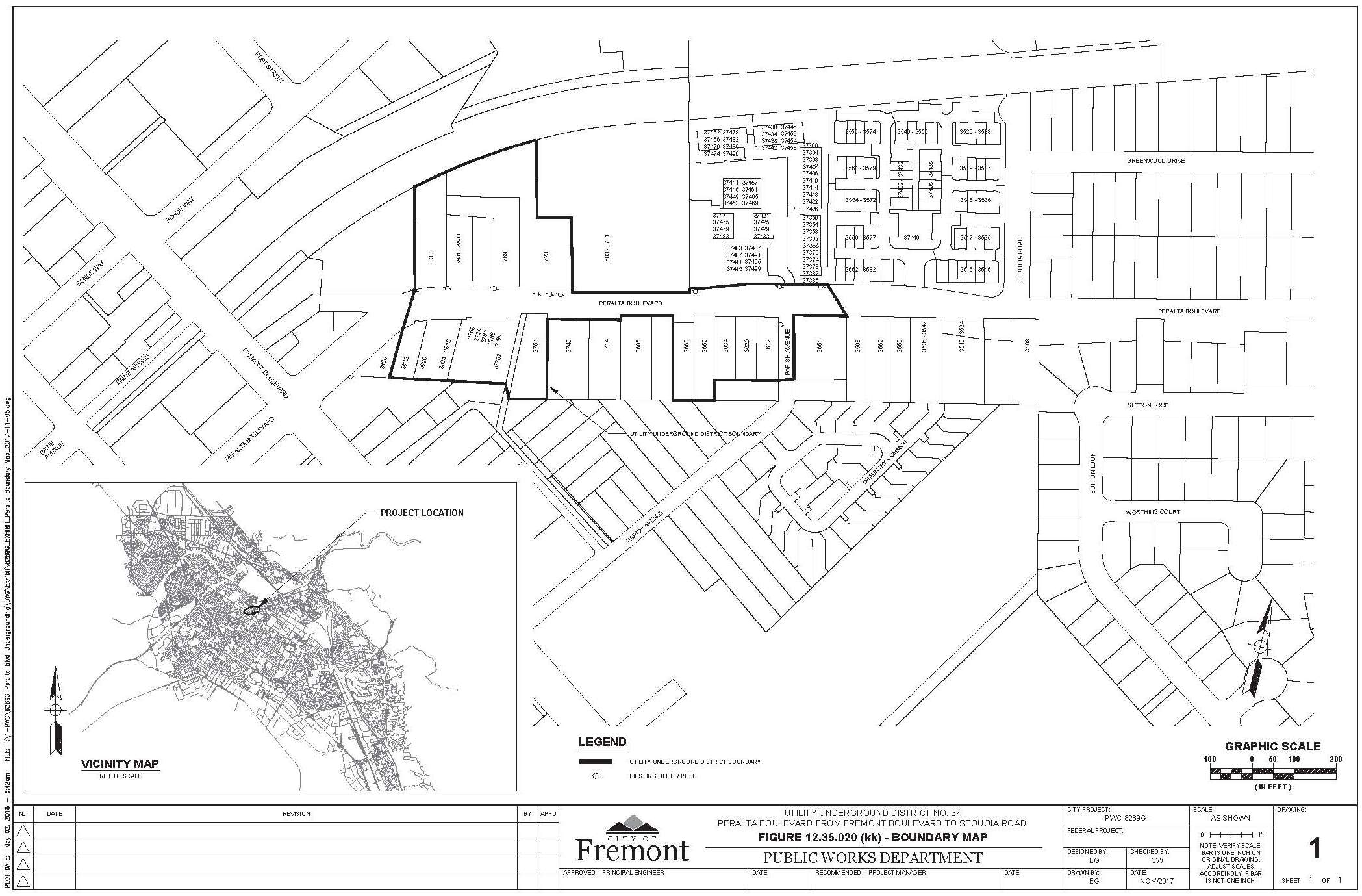
Every person maintaining any overhead electric power or communication pole, wire, facility or other structure in the above-described utility underground district, except as provided in this chapter, is hereby required to remove and replace the same within an underground system as required by this chapter.
The city council hereby orders the removal of all poles, overhead wires and associated overhead structures, and the underground installation of wires and facilities for supplying electric, communication or similar or associated service within Utility Underground District No. 37 on or before February 28, 2020.
(ll) District No. 38.
All that property situated in the State of California, County of Alameda, City of Fremont lying within the boundary along Fremont Boulevard between Alder Avenue and Thornton Avenue as depicted in Figure 12.35.020(ll) entitled, “Utility Underground District No. 38 – Fremont Boulevard from Alder Avenue to Thornton Avenue.”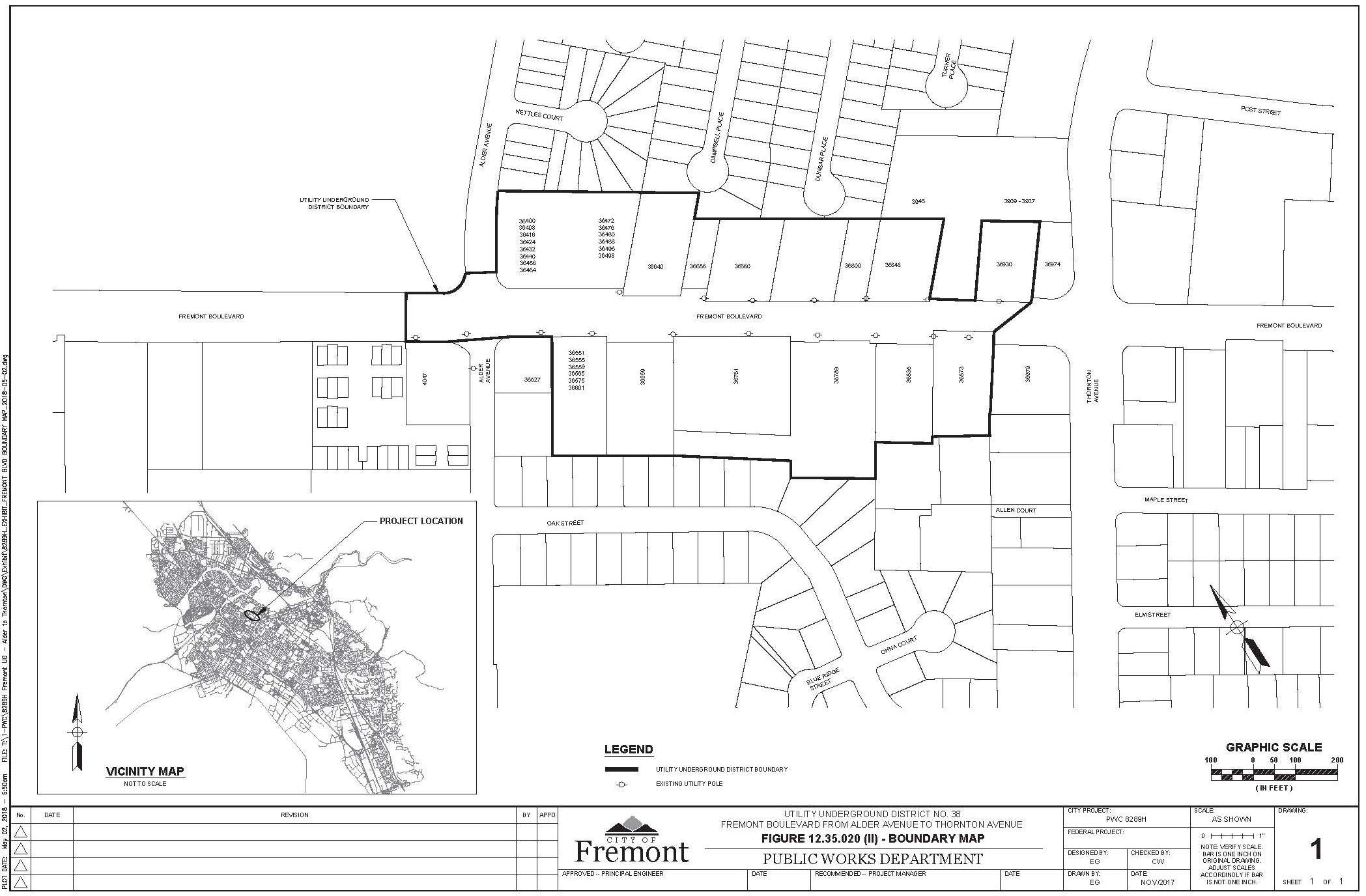
Every person maintaining any overhead electric power or communication pole, wire, facility or other structure in the above-described utility underground district, except as provided in this chapter, is hereby required to remove and replace the same within an underground system as required by this chapter.
The city council hereby orders the removal of all poles, overhead wires and associated overhead structures, and the underground installation of wires and facilities for supplying electric, communication or similar or associated service within Utility Underground District No. 38 on or before February 20, 2020. (Ord. 263 § 1; Ord. 335 § 1; Ord. 460 § 1; Ord. 513 § 1; Ord. 551 § 1; Ord. 631 §§ 1, 10, 11; Ord. 651 § 1; Ord. 806 § 1, 11-17-70; Ord. 826 § 1, 3-23-71; Ord. 869 § 1, 10-12-71; Ord. 913 § 1, 7-11-72; Ord. 998 § 1, 6-25-74; Ord. 1034 § 1, 3-4-75; Ord. 1203 § 1, 10-4-77; Ord. 1291 § 1, 11-21-78; Ord. 1385 § 1, 6-17-80; Ord. 1629 § 1, 9-11-84; Ord. 1648 § 1, 2-12-85; Ord. 1649 § 1, 2-12-85; Ord. 1650 § 1, 2-12-85; Ord. 1651 § 1, 2-12-85; Ord. 1670 § 2, 6-25-85; Ord. 1671 § 2, 7-2-85; Ord. 1719 § 1, 4-15-86; Ord. 1820 § 1, 5-10-88; Ord. 1845 § 1, 11-1-88; Ord. 1904 § 1, 12-19-89; Ord. 2027 § 1, 4-6-93; Ord. 2083 § 1, 8-2-94; Ord. 2110 § 1, 2-21-95; Ord. 2129 § 1, 8-1-95; Ord. 2219 § 1, 2-4-97; Ord. 2222 § 1, 2-11-97; Ord. 2247 § 1, 7-1-97; Ord. 2259 § 1, 12-2-97; Ord. 2271 § 1, 12-16-97; Ord. 2284 § 1, 3-17-98; Ord. 2349 § 1, 7-27-99; Ord. 2350 § 1, 9-7-99; Ord. 2403 § 1, 10-3-00; Ord. 2436 § 1, 9-4-01; Ord. 2453 § 1, 3-5-02; Ord. 2514 § 1, 9-23-03; Ord. 2520 § 1, 11-4-03; Ord. 36-2004 § 1, 11-2-04; Ord. 10-2008 § 2, 5-27-08; Ord. 11-2018 § 2, 4-17-18; Ord. 12-2018 § 2, 4-17-18. 1990 Code § 6-3101.)
12.35.030 Overhead wires not to be erected in underground districts.
From and after the effective date of the establishment of any utility underground district, it shall be unlawful for any person to erect or construct any overhead utility lines or wires, poles or other associated overhead utility facilities within such utility underground district. (Ord. 263 § 1. 1990 Code § 6-3102.)
12.35.040 Granting of special exceptions.
(a) Notwithstanding any other provisions of this chapter except as provided in subsections (b) and (c) of this section, the public works director may, subject to the provisions of this subsection, grant special permission, on such terms as he/she may deem appropriate in cases of emergency or unusual circumstances, or in cases of minor work, without discrimination, to any person to erect, construct, install, maintain, use or operate, poles and overhead wires and other associated facilities and structures above ground within any utility underground district; provided, that prior thereto, the public works director shall have made a finding that the granting of such special permission does not violate the general purposes of this chapter, will not be detrimental to the public interest, welfare, safety, peace or health, and that such action will not constitute a grant of special privilege inconsistent with the limitations upon other properties in the utility underground district. The decision of the public works director is appealable to the city council pursuant to Chapter 1.25.
(b) Notwithstanding any other provisions of this chapter, the planning commission may, subject to the provisions of this subsection (b), grant special permission to any person proposing to develop as a subdivision or unified development (excepting planned districts established pursuant to Title 18) real property exceeding four acres in size, to erect, construct, maintain, use or operate, poles and overhead wires and other associated facilities and structures above ground within any utility underground district in the manner and method known as “streamline,” or any other system or method which does not comply with the literal and complete undergrounding requirements of this chapter but which is approved by resolution of the city council as a method or system consistent with the basic purposes of this chapter for the purpose of this section and which system or method may or shall be used in addition to or in lieu of “streamline” installation and in lieu of said requirements. Before the planning commission acts upon any particular request for such special permission, the matter shall first be referred to the public works director for report and recommendation. The planning commission may approve or disapprove the recommendation of the public works director, in whole or in part, but in any case the planning commission shall not grant the requested special permission unless not less than four members of the planning commission shall have made findings that the land involved is affected by the existence of widespread subsurface rock or other topographical conditions which make it impossible or impractical for such person fully to conform to the regulations contained in this chapter because such conformance would be unreasonable under recognized and established engineering and economic criteria which are specifically reviewed by the public works director and the planning commission in connection with the particular proposal, and that plans for the proposed subdivision or other development disclose that revision or alterations thereto would not substantially change the previous referred-to findings. The decision of the planning commission is appealable to the city council pursuant to Chapter 1.25.
(c) Notwithstanding Section 12.35.060(a) or other provisions of this chapter, a utility may interset additional poles or other supporting structures or increase the height of existing poles or other supporting structures, within the existing easements and locational confines of existing overhead utility facilities, subject to rules and regulations or policy specifically adopted by resolution of the city council to provide for exceptions pursuant to this subsection (c). (Ord. 263 § 1; Ord. 513 § 3; Ord. 631 § 2; amended during 2012 reformat. 1990 Code § 6-3103.)
12.35.050 Granting of special exceptions – Fees.
The special permission to erect, construct, install, maintain, use or operate poles and overhead wires and other associated facilities and structures above ground in any utility underground district, as provided for in Section 12.35.040(a) and (b), shall be subject to a fee, as set by resolution of the city council. (Ord. 832 § 14, 4-20-71. 1990 Code § 6-3103.5.)
12.35.060 Certain facilities excepted.
Notwithstanding any other provisions of this title, the following utility facilities may be maintained (or constructed, if not falling within the purview of subsection (a) of this section) in any utility underground district:
(a) Existing Facilities. Unless it is provided to the contrary in the provisions of Section 12.35.020 in regard to a particular utility underground district, every person maintaining any overhead electric power or communication pole, wire, conduit, facility, or other structure or appurtenance, existing on or before the establishment of a utility underground district in which said facilities or structures are located, may continue to maintain, repair, replace, and reinforce any such facility or structure in order to maintain the integrity of existing facilities, providing that no additional or other supporting structures are erected, or existing poles or other supporting structures are increased in height; provided, however, that a utility may expand such existing facilities and structures, provided such expansion is within the existing easements and locational confines of such existing facilities and structures, and does not involve the intersetting of additional poles or other supporting structures or an increase in the height of existing poles or other supporting structures.
(b) Appurtenant Facilities. Associated equipment and facilities which are appurtenant to underground utility systems, such as substations, surface-mounted transformers (except as provided herein in residential districts), pedestal-mounted meter cabinets, and concealed ducts; provided, however, that such appurtenant facilities shall be effectively screened from view by solid fencing, landscaping or other means, said screening to be subject to the approval of the zoning administrator. In all residential districts, established pursuant to the zoning ordinance (Title 18), transformers for electric power may be surface-mounted, pursuant to the above provisions of this subsection, only within approved public utility easements located either (1) adjacent to the intersection of rear lot lines and side street lot lines, or (2) adjacent to the rear lot line upon a lot or at the intersection of rear lot lines and side lot lines upon two lots which lot or lots are adjacent to any public property or easement which has been designated, set aside, or is used, as a pedestrian walkway, trail, path, lane, or way, or as an equestrian trail, path, lane or way; provided, that any such walkway, trail, path, lane or way shall be of sufficient width and otherwise designed and constructed so as to permit access to any transformer located therein by vehicles used in the maintenance of such transformers without damage to the pavement, landscaping and other improvements within such walkway, trail, path, lane or way. As an additional alternative to such locations, such transformers may be surface-mounted, in apartment developments, within any side or rear yard which is not bounded by a street lot line, or within any open court or other interior open area adjacent to main buildings which open area is not part of the principal yard areas of the lot upon which such buildings are located; provided, that any such transformer shall be located within an approved utility easement upon the lot.
(c) Pedestal-Mounted Terminal Boxes. Pedestal-mounted terminal boxes and associated appurtenances used for telephone or electric service, provided the external design and appearance of any such box are approved by the zoning administrator or are screened in a manner approved by the zoning administrator. No such box shall exceed three feet in height or have a diameter greater than 20 inches; provided, that the zoning administrator may allow such dimensions to be exceeded in any case where such a special exception is found not to violate the general purposes of this title.
(d) Communications Antennas. Communications antennas to which are attached no overhead wires not integral with the structural components of the antennas.
(e) Continuous Lead Crossings. Overhead wires (whose supporting structures are not within the district) crossing any portion of a utility underground district from which overhead wires have been prohibited, or connecting to buildings on the perimeter of such portion, when such wires originate in an area or areas from which poles and overhead wires and associated overhead structures are not prohibited.
(f) Renewable Energy Systems. Renewable energy systems as that term is defined in Section 18.185.030. (Ord. 263 § 1; Ord. 513 § 4; Ord. 631 § 3; Ord. 726 § 1; Ord. 7-2012 § 2, 5-1-12; Ord. 9-2014 § 3, 3-4-14. 1990 Code § 6-3104.)
12.35.070 Certain facilities excepted under certain circumstances.
Notwithstanding any other provisions of this chapter, certain utility facilities may be erected, constructed and maintained overhead in any utility underground district if within certain specified locations or subject to certain specified circumstances, as follows:
(a) Within any industrial zoning district, established pursuant to the zoning ordinance (Title 18), all utility facilities may be erected, constructed and maintained overhead except that street lighting within any such district shall be installed with and served by underground electric wires and lines; provided, that notwithstanding the premises of this section and the general exception provided in this subsection, this exception shall not be applicable to any industrial district or portion thereof which is specifically included within a utility underground district established after August 8, 1967.
(b) Reserved.
(c) Single-Family Residence (R-1) Zoning Districts. Within any single-family residence (R-1) land use zoning district, established pursuant to the zoning ordinance, any parcel or parcels proposed to be developed for residential use (not as a subdivision) may be served by overhead utility facilities if such parcel or parcels are within an area within an R-1 district which is developed and served by existing overhead utility facilities; provided, that this exception shall apply only if no additional poles or other supporting structures are required to serve the parcel or parcels proposed to be developed.
(d) Transmission Lines. Overhead wires and supporting structures for transmission lines rated at 50,000 volt capacity or more, designed to carry a load of at least 20,000 kilovolt amperes may be erected, constructed and maintained overhead within any area of the city; provided, that a conditional use permit is granted by the planning commission pursuant to Chapter 18.230 permitting or conditionally permitting a proposed transmission line of such rating, capacity and load to be erected, constructed and maintained overhead.
(e) Emergencies. For any bona fide emergency reason, including but not limited to applicable regulations of the commission, overhead utility facilities may be erected, constructed and maintained by a utility for a period not exceeding 10 days. No permit shall be required for such emergency facilities; provided, that the utility, within two days of the installation or construction of such facilities (if maintained that long), gives written notice thereof to the city public works director, including a brief statement of the facts justifying the overhead facilities. Any such facilities requiring maintenance for a period longer than 10 days shall be installed, constructed and maintained pursuant to Section 12.35.040(a) or other applicable provisions of this chapter.
(f) Construction Projects. Temporary overhead utility facilities may be erected, constructed and maintained in connection with and during the construction of improvements to property, including utility service for any such construction project and the erection, construction and installation of permanent utility facilities. A permit to erect or construct such utility facilities shall be obtained from the city electrical inspector who may impose appropriate conditions concerning location of such facilities; provided, that where the city electrical inspector finds in connection with any proposed construction project, that the related overhead utility facilities are proposed to be or are likely to be maintained for a period in excess of 18 calendar months, he/she may, in his/her discretion, refuse to issue a permit. Any construction project not qualifying under the above criteria may be permitted to utilize overhead utility facilities pursuant to exceptions allowed in accordance with Section 12.35.040(a) or other applicable provisions of this chapter; provided, that such project qualifies thereunder. All overhead utility facilities erected, constructed and maintained in connection with the construction of improvements to real property and which overhead utility facilities are otherwise prohibited by this chapter shall be removed prior to use and occupancy of any such improvements.
(g) Temporary and Seasonal Uses. Temporary overhead facilities may be erected, constructed, and maintained for a period not to exceed 60 days in connection with temporary and seasonal uses, provided the temporary overhead facilities do not extend more than 200 feet beyond the boundaries of the parcel being served. A permit to erect or construct such utility facilities shall be obtained from the city electrical inspector, who may impose appropriate conditions concerning location of such facilities. Where a particular property is used regularly or on frequent occasions for the same or different temporary and seasonal uses, the city electrical inspector may notify the property owner that in the future any such overhead utility facilities will not be again permitted unless such overhead utility facilities may be allowed in accordance with Section 12.35.040(a) or other applicable provisions of this chapter, provided any such overhead utility facilities qualify thereunder.
(h) Residential Zoned Districts. Within any residential zoned district established pursuant to the zoning ordinance, any parcel or parcels of land proposed to be developed as a subdivision may maintain existing overhead facilities on frontages that conform to the following conditions:
(1) The street frontage abutting the parcel is a minor street not designated as an arterial, parkway, major thoroughfare or secondary thoroughfare on the Fremont general plan and as defined in Section 17.25.060(b).
(2) The frontage is not planned for undergrounding under a city program funded with any combination of public or utility company funds. (Ord. 631 § 4; Ord. 827 § 1, 3-30-71; Ord. 2048 § 1, 10-5-93; amended during 2012 reformat; Ord. 04-2016 § 1, 3-1-16. 1990 Code § 6-3104.5.)
12.35.080 Notice to property owners and utilities.
Within 30 days after establishment of the utility underground district, the public works director shall so notify all affected utilities and all persons owning real property within the affected area. The public works director shall further notify such affected property owners that overhead facilities are to be removed and that if such property owners, their tenants or occupants of their property desire to continue to receive utility service or services, they shall make all necessary wiring changes on their premises so as to receive service from the utility company at a new location subject to the applicable rules, regulations and tariffs of the respective utilities on file with the commission. Notification shall be made by mailing a copy of this chapter and ordinance which designates the area a utility underground district, to the affected utilities and to affected property owners as shown on the last equalized assessment roll of the city. The property owner, tenant or occupant shall cause such changes to be accomplished on or before the date specified in the ordinance which includes the property within the utility underground district. If any such property owner, tenant or occupant shall fail to make the necessary changes in the electric wiring on his/her premises and thereby prevents the utility from removing its overhead service wires, the public works director shall have the authority to order the disconnection of such service wires from the premises of such property owner, tenant or occupant and the utility, after receipt of such order, shall not be thereafter required to provide service to such premises until the owner, tenant or occupant makes the necessary changes. Alternatively or in addition to such disconnection of service, the public works director may, where the property owner refuses to comply within a reasonable time, as specified in the foregoing provisions, effect removal or preparation of the property to accept underground utility lines in accordance with the applicable rules of the utility involved and, after due notice to such property owner, cause such work to be done and assess the costs thereof, and any costs incurred in disconnection of service as provided herein, against the property. The public works director shall file a certified statement of costs with the city clerk, who shall give notice to the property owner that the city council, sitting as a board of equalization, shall hold a hearing, on a specified date, at which time the council may modify or correct any such assessment which in its opinion is excessive or otherwise incorrect. As approved by the city council, such assessments shall be deemed confirmed and the council’s decision shall be conclusive, and the same shall thereupon become a lien against the property involved. If any such confirmed assessment is not paid prior to the time fixed by law for establishing and fixing the next equalized assessment roll of the city, the confirmed assessment shall be collected at the same time and in the same manner as ordinary municipal ad valorem taxes are collected, and shall be subject to the same penalty and the same procedure and sale in case of delinquencies as provided for such taxes. All laws applicable to the levy, collection and enforcement of municipal ad valorem taxes shall be applicable to any such assessment. (Ord. 263 § 1; Ord. 739 § 1; Ord. 828 § 1, 3-30-71; amended during 2012 reformat. 1990 Code § 6-3105.)
12.35.090 Responsibility of utility companies.
If underground construction is necessary to provide utility service within a utility underground district, the supplying utility shall furnish that portion of the conduits, conductors and associated equipment required to be furnished by it under its applicable rules, regulations and tariffs on file with the commission. (Ord. 263 § 1; Ord. 828 § 1, 3-30-71. 1990 Code § 6-3106.)
12.35.100 Responsibility of property owners.
(a) Every person owning, operating, leasing, occupying or renting a building or structure within a utility underground district shall perform construction and provide that portion of the service connection on his/her property between the facilities referred to in Section 12.35.090 and the termination facility on or within said building or structure being served, all in accordance with applicable rules, regulations and tariffs of the respective utility or utilities on file with the commission.
(b) In the event any person owning, operating, leasing, occupying or renting said property does not comply with the provisions of subsection (a) of this section within the time provided for in this chapter which includes said property within the utility underground district, the public works director shall post written notice on the property being served and 30 days thereafter shall have the authority to order the disconnection and removal of any and all overhead service wires and associated facilities supplying utility service to said property. (Ord. 263 § 1; Ord. 828 § 1, 3-30-71; amended during 2012 reformat. 1990 Code § 6-3107.)
12.35.110 Time extensions for emergencies.
In the event that any act hereby required by any parties herein referred to cannot be performed within the time herein provided on account of shortage of materials, war, restraint by public authorities, strikes or any other similar circumstances beyond the control of the parties, then the time within which such act shall be accomplished shall be extended for a period equivalent to the time of such limitations. (Ord. 263 § 1. 1990 Code § 6-3108.)
12.35.120 Compliance prior to building permit issuance.
Any person applying for a building permit or other permit or permission to improve land located within any utility underground district, or desiring electric power or communication service to serve any such land shall be responsible for compliance with this chapter, and no such building permit or other permit or permission shall be issued or given unless and until such person shall submit satisfactory proof that necessary arrangements have been made with the utility companies (or agencies) involved for underground installation of facilities as required pursuant to this chapter. (Ord. 513 § 5. 1990 Code § 6-3109.)