Chapter 18.186
SOLAR ACCESS PRESERVATION
Sections:
18.186.030 Basic requirement – Solar access preservation setback.
18.186.050 Alternatives to the solar access preservation setback.
18.186.060 Shadow plans and diagrams.
18.186.070 Guidelines and administration.
18.186.010 Basis and purpose.
In enacting this chapter, the city finds that:
(a) Solar access is of increasing importance to the achievement of sustainability and climate action plan goals.
(b) The installation of solar systems represents a significant investment by property owners and impairment to solar access could result in significant losses in energy output and corresponding financial impacts.
(c) Preservation of solar access for northerly-located properties may limit southerly-located development; however, preserving solar access is in the best interest of the health, safety, and general welfare of the community. (Ord. 17-2017 § 7, 11-7-17.)
18.186.020 Definitions.
The following definitions apply to this chapter only:
“Base elevation” shall mean the elevation of the highest point of contact of a structure with the adjacent ground along the northerly property line.
“Difference in height” shall mean the difference between the height of the structures measured from their respective base elevations to the:
(1) Eave of the roof if the roof slope has a pitch less than 7:12; or
(2) Apex of the ridge of the roof if the gable end of the roof is adjacent to a northerly property line; or
(3) Top of the parapet wall if the roof is flat.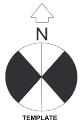
“Northerly lot line” shall mean any lot line that forms a generally north-facing boundary of a lot and has a bearing greater than or equal to 40 degrees from either true north or true south. There may be more than one northerly lot line per lot. For curved lot lines, the bearing of the lot line at any point shall be the bearing of the tangent to the curve at that point. The template to the right may be used to determine northerly lot lines.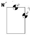
Example: First find true north. Then eliminate all lot lines that are obviously not on the northern edges of the property. Now use the template above and place the center of the circle on one of the remaining lot lines, pointing the north arrow towards true north. If the lot line in question runs through the black area, it is a northerly property line. This example has two northerly property lines.
“Shadow plan” shall mean a plot plan, which shows the extent of shading caused by a proposed structure in compliance with the rules and regulations approved pursuant to this chapter.
“Solar production” shall mean the amount of energy generated from the solar system in terms of annual kilowatt hours of electricity obtained from the most recent year of generation data. For a potential solar system, the solar production shall be estimated by calculating the amount of energy that could be generated in the first year from the solar zone in terms of annual kilowatt hours of electricity.
“Solar zone” shall mean an allocated space that is unshaded, unpenetrated, and free of obstructions that serves as a suitable place that solar panels can be installed at a future date. The solar zone shall adhere to the requirements of the most recently adopted building code, including any local amendments thereto. (Ord. 17-2017 § 7, 11-7-17.)
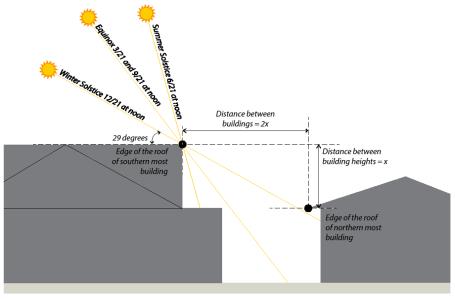
18.186.030 Basic requirement – Solar access preservation setback.
New structures and vertical additions to existing structures shall observe a setback equal to or greater than two times the difference in height between the proposed structure and any adjacent structure(s) located along northerly lot line(s). See Section 18.186.050 for alternatives to the basic requirement. The following diagrams illustrate the solar access preservation setback requirements:
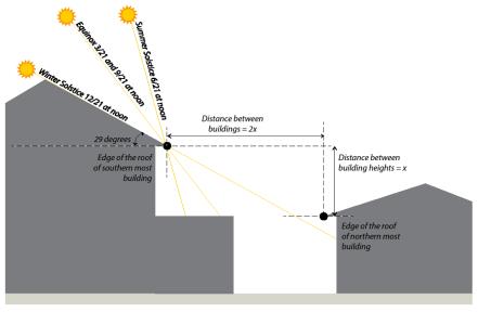
Addition with a hip roof form near the roof of the northernmost building’s roof.
Addition with a gable roof form near the northernmost building’s roof.
(Ord. 17-2017 § 7, 11-7-17; Ord. 05-2021 § 42, 4-20-21.)
18.186.040 Exemptions.
The provisions of this chapter shall not apply to:
(a) Any structure for which a valid building permit was issued and any project having received discretionary approvals or a complete design review application prior to December 7, 2017.
(b) Structures within the downtown, city center, town center, multifamily residential (R-3-30 or greater), or Warm Springs innovation districts.
(c) Any flagpole, antenna, ornamental spire, chimney, wireless facility, or other building element less than four feet along each horizontal dimension.
(d) Any light pole or utility pole and lines.
(e) Any wireless facility subject to review under Section 18.187.040(b) or subject to an exception from standards pursuant to Section 18.187.170.
(f) Any portion of a structure that does not exceed the boundaries of a simultaneous shadow cast by a legally existing structure, or by a hill or other topographical feature other than trees or other vegetation. (Ord. 17-2017 § 7, 11-7-17; Ord. 05-2021 § 43, 4-20-21.)
18.186.050 Alternatives to the solar access preservation setback.
As an alternative to the basic requirement set forth in Section 18.186.030, a property owner may:
(a) Cause to have prepared a more refined shadow plan in accordance with Section 18.186.060 to demonstrate a lesser setback is sufficient to protect existing systems or potential solar zones on adjacent properties.
(b) Acquire a solar shading easement from the affected adjacent property owner(s) allowing partial shading of a solar zone. The city attorney shall review the easement language for conformity with this section prior to the easement being recorded on the affected properties with the Alameda County recorder.
(c) Demonstrate through a solar study that:
(1) Any solar shading will impact less than five percent of the annual production from an existing or potential solar zone on an affected adjacent property. Use of this alternative requires approval from the affected property owner(s); and
(2) That an existing solar thermal (e.g., domestic hot water, radiant heating or pool heating) system will not be shaded. (Ord. 17-2017 § 7, 11-7-17; Ord. 05-2021 § 44, 4-20-21.)
18.186.060 Shadow plans and diagrams.
(a) In order to use either alternative described in Section 18.186.050(a) or (c), the property owner shall submit a shadow plan prepared by a qualified professional with accompanying diagrams including the following information:
(1) A true north arrow;
(2) Topography of the proposed site and any adjacent northerly lots, and existing improvements thereon;
(3) Site plan and exterior elevations of the proposed structure showing the location of all northerly property lines on both site plan and elevations;
(4) Diagrams of the shadows cast at 10:00 a.m., 12:00 p.m., and 2:00 p.m. Pacific Standard Time on December 21st by the structure, or portion thereof, being considered; and
(5) Any other information deemed necessary by the community development director.
(b) The shadow plan and diagrams may be included on the site plan or may be shown as a separate drawing.
(c) The city may require a peer review by a qualified consultant to verify the study is properly prepared and accurately represents solar shading or the lack thereof. (Ord. 17-2017 § 7, 11-7-17.)
18.186.070 Guidelines and administration.
The community development director may develop additional guidelines and create examples, templates or tools for the administration and interpretation of this chapter. (Ord. 17-2017 § 7, 11-7-17.)