


Part 3. Site Planning and Development Standards
Chapter 21.30
PROPERTY DEVELOPMENT STANDARDS
Sections:
21.30.010 Purpose and Applicability.
21.30.015 General Site Planning and Development Standards.
21.30.025 Coastal Zone Subdivisions.
21.30.030 Natural Landform and Shoreline Protection.
21.30.040 Fences, Hedges, Walls, and Retaining Walls.
21.30.050 Grade Establishment.
21.30.060 Height Limits and Exceptions.
21.30.085 Water Efficient Landscaping.
21.30.100 Scenic and Visual Quality Protection.
21.30.105 Cultural Resource Protection.
21.30.110 Setback Regulations and Exceptions.
21.30.130 Traffic Safety Visibility Area.
21.30.010 Purpose and Applicability.
The purpose of this chapter is to ensure that development is consistent with the Coastal Land Use Plan, complies with the standards of this chapter, produces an environment that is harmonious with existing and future development, and protects the use and enjoyment of neighboring properties.
The standards of this chapter apply to all coastal zoning districts. These standards shall be considered in combination with the standards for each coastal zoning district in Part 2 (Coastal Zoning Districts, Allowable Land Uses, and Coastal Zoning District Standards) and Part 4 of this Implementation Plan (Standards for Specific Land Uses). Where there may be a conflict, the standards that are most restrictive and/or most protective of coastal resources shall prevail.
All structures, additions to structures, and uses shall conform to the applicable standards of this chapter as determined by the Director. (Ord. 2016-19 § 9 (Exh. A)(part), 2016)
21.30.015 General Site Planning and Development Standards.
A. Purpose. This section provides general standards for siting and planning development in the coastal zone, as well as more specific standards applicable to development along the waterfront and on bluffs and canyons.
B. Location of New Development. New development shall be located in areas with adequate public services or in areas that are capable of having public services extended or expanded without significant adverse effects on coastal resources. Redevelopment and infill development shall be allowed within and adjacent to the existing developed areas in the coastal zone subject to the density and intensity limits and resource protection policies of the Coastal Land Use Plan.
C. Nonresidential Waterfront Development.
1. Applicability. This subsection applies to coastal development permit applications for development on nonresidential properties, including, but not limited to, coastal-dependent, marine-related and visitor-serving commercial uses, fronting on the waterfront of Newport Bay, the Pacific Ocean, the Old Channel of the Santa Ana River (the Oxbow Loop), or the channels in West Newport. The Coastal Land Use Plan and the Coastal Act protect coastal-dependent, marine-related and visitor-serving commercial uses as priority commercial uses on properties on or near the shoreline.
2. Considerations. In reviewing a coastal development permit application for development, the review authority shall consider the following:
a. Whether the development reduces coastal-dependent commercial uses and/or allows coastal-dependent uses to remain;
b. The suitability of the site to accommodate coastal-dependent uses;
c. The development’s ability to accommodate coastal-related uses;
d. The developments ability to create waterfront public spaces and beaches, with adjacent water access and docking facilities, that serve as the identity and activity “centers” of Newport Harbor for special events of community/regional interest;
e. Potential impacts to existing coastal-dependent and coastal-related developments, both on development site and on adjacent properties;
f. The adequacy of marine-related facilities and the present and foreseeable demand for such facilities;
g. The compatibility of the proposed development with the height, bulk, scale and building frontages of surrounding development;
h. Whether the development is so sited and designed as to minimize, and where feasible, avoid shoreline hazards identified in compliance with subsection (E) of this section, Development in Shoreline Hazardous Areas; and
i. Whether any boating facilities (e.g., piers, pier platforms, gangways and dock floats) associated with the nonresidential waterfront development are so sited and designed to protect, and where feasible, expand and enhance public access to and along shoreline areas.
3. Development Standards.
a. Public Access to Bay Front. Public access and recreational opportunities shall be protected, and where feasible, expanded and enhanced. The dedication and improvement of public access to and along the waterfront, in conjunction with proposed development and new land uses, shall be required pursuant to Chapter 21.30A (Public Access and Recreation).
b. Commercial Development. Development shall be consistent with the specific district/corridor policies of Chapter 2 of the Coastal Land Use Plan, including, but not limited to, those policies applicable to West Newport (2.1.3); Mariner’s Mile (2.1.4); Balboa Peninsula (2.1.5); Balboa Island (2.1.6); Newport Dunes (2.1.7); and Balboa Bay Club (2.1.8) and for visitor-serving and recreational development (2.3); and coastal-dependent/related development (2.4).
c. Priority Uses. Protect existing and give priority to new coastal-dependent, marine-related and visitor-serving commercial uses on properties on or near the shoreline. For bay-fronting CV and CM District properties, provide new marine-related and visitor-serving retail, restaurant, hotel/motel, institutional, and recreational uses, where feasible.
d. Pump-out Facilities Required. On waterfront sites where the proposed use includes public marinas, yacht clubs, boat charters or rentals, sports fishing establishments, commercial fishing facilities, boat launching facilities, or other similar uses, either public or private, boat holding tank pump-out facilities shall be provided in each case, unless otherwise approved by the review authority as part of a coastal development permit. Said pump-out facilities shall have adequate capacity to accommodate all vessels anticipated at each site. Prior to the issuance of building permits, the Harbor Resources Manager shall approve all plans and specifications of pump-out facilities.
e. Newport Harbor. Development in Newport Harbor shall comply with the development standards of Section 21.48.035 (Newport Harbor).
f. Harbor and Bay Regulations. Development shall comply with development standards for structures in Newport Bay provided in Chapter 21.30C (Harbor and Bay Regulations).
g. Development shall comply with subsection (E) of this section, Development in Shoreline Hazardous Areas, and Section 21.30.030, Natural Landform and Shoreline Protection, as applicable.
D. Waterfront Development.
1. Applicability. This subsection applies to coastal development permit applications for development on residential and nonresidential properties fronting on the waterfront of Newport Bay, the Pacific Ocean, the Old Channel of the Santa Ana River (the Oxbow Loop), or the channels in West Newport and the shoreline areas identified in Section IV of Appendix A of this Implementation Plan. These regulations are in addition to those contained in subsection (C) of this section.
2. Considerations. In reviewing a coastal development permit application for development along the waterfront, the review authority shall consider the following:
a. The compatibility of the proposed development with the height, bulk, scale and building frontages of surrounding development;
b. The presence of an existing bulkhead, retaining wall or other similar structure seaward of the proposed development and whether such structure is located on private property or State tidelands and in alignment with structures on adjacent properties;
c. The need for the existing or potential future bulkhead or similar device to protect the proposed development, and the ability to remove such protective device now or in the future;
d. The development’s ability to enhance public access to State tidelands and shoreline areas through project siting and design or conditions of approval;
e. Whether the development is designed and sited so as to minimize, and where feasible, avoid shoreline hazards identified in compliance with subsection (E) of this section (Development in Shoreline Hazardous Areas);
f. Whether any boating facilities (e.g., piers, pier platforms, gangways and dock floats) associated with waterfront development are so sited and designed to protect, and where feasible, expand and enhance public access to and along shoreline areas;
g. Whether the structure is nonconforming with regard to setbacks from the shoreline, bluff and/or bulkhead; and
h. For improvements to existing structures, whether the proposed improvements increase the degree of nonconformity or result in replacement of more than fifty (50) percent of the existing structure.
3. Development Standards.
a. New development shall be designed and sited to assure stability and structural integrity and avoid destruction of the site and surrounding area by providing setbacks for principal structures that avoid the need for new or perpetuation of existing shoreline protective devices to the extent possible;
b. The minimum required top of slab elevation for interior living areas of all new structures shall be as established by the Flood Insurance Rate Maps recognized by the Building Division as part of flood safety requirements and maps adopted by the Council (see Section 21.30.060(B)(3)) or higher where recommended by the coastal hazards report required by subsection (E)(2) of this section with acknowledgment of potential need for adaption measures in the future to address flood potential and sea level rise. Notwithstanding the building elevations established by the Flood Insurance Rate Maps, the minimum required top of slab elevation for interior living areas of all new structures shall be at least 9.00 (NAVD 88);
c. The applicant and property owner shall acknowledge any hazards present at the site, assume the risk of injury and damage from such hazards, unconditionally waive any claim of damage or liability against the decision authority from such hazards, and to indemnify and hold harmless the decision making authority against any and all liabilities, claims, demands, damages, costs, expenses, and amounts paid in settlement arising from any injury or damage due to such hazards;
d. All nonconforming structures particularly when located on State tidelands or beaches available for public use shall be removed;
e. Any existing impediments to public access shall be removed, wherever possible;
f. New development shall protect, and where feasible, expand and complete lateral public pedestrian access along the waterfront with connectivity to beaches, street-ends and shoreline areas providing public access (see Chapter 21.30A (Public Access and Recreation);
g. Development shall comply with subsection (E) of this section, Development in Shoreline Hazardous Areas, and Section 21.30.030, Natural Landform and Shoreline Protection, as applicable;
h. New development and/or replacement structures shall be brought into conformity with current standards for setbacks from the shoreline, bluff and/or bulkhead.
E. Development in Shoreline Hazardous Areas.
1. Applicability. This subsection shall apply to coastal development permit applications for proposed development located in:
a. Shoreline areas identified as hazardous in the most current Local Hazard Mitigation Plan (LHMP);
b. Shoreline areas identified in Section IV of Appendix A of this Implementation Plan; and
c. Shoreline areas that are reasonably expected to be impacted by sea level rise based on the best available science over the lifetime of the new development.
2. Coastal Hazards Report. Coastal development permit applications for development proposed in shoreline areas subject to current or expected future erosion, flooding/inundation, wave runup, or wave impacts, including those resulting from sea level rise, shall include a coastal hazards report. The coastal hazards report shall use the methodology in Appendix A and include the following:
a. A statement of the preparer’s qualifications;
b. Identification of coastal hazards affecting the site;
c. An analysis of the following conditions:
i. A seasonally eroded beach combined with long-term (seventy-five (75) year) erosion factoring in sea level rise;
ii. High tide conditions, combined with long-term (seventy-five (75) year) projections for sea level rise;
iii. Storm waves from a one hundred (100) year event or a storm that compares to the 1982/83 El Niño event;
iv. An analysis of bluff stability; a quantitative slope stability analysis that shows either that the bluff currently possesses a factor of safety against sliding of at least 1.5 under static conditions, and 1.1 under seismic (pseudostatic conditions); or the distance from the bluff edge needed to achieve these factors of safety; and
v. Demonstration that development will be sited such that it maintains a factor of safety against sliding of at least 1.5 under static conditions and 1.1 under seismic (pseudostatic) conditions for its economic life (generally seventy-five (75) years). This generally means that the setback necessary to achieve a factor of safety of 1.5 (static) and 1.1 (pseudostatic) today must be added to the expected amount of bluff erosion over the economic life of the development (generally seventy-five (75) years);
d. On sites with an existing bulkhead, a determination as to whether the existing bulkhead can be removed and/or the existing or a replacement bulkhead is required to protect existing principal structures and adjacent development or public facilities on the site or in the surrounding areas; and
e. Identification of necessary mitigation measures to address current hazardous conditions such as siting development away from hazardous areas and elevating the finished floor of structures to be at or above the base flood elevation including measures that may be required in the future to address increased erosion and flooding due to sea level rise such as waterproofing, flood shields, watertight doors, moveable floodwalls, partitions, water-resistive sealant devices, sandbagging and other similar flood-proofing techniques.
3. Bulkhead Condition Report. Where a coastal hazards report shows that an existing bulkhead on the site cannot be removed and/or an existing or replacement bulkhead is required to protect existing principal structures or public facilities, the applicant shall submit a bulkhead condition report that includes the following:
a. A statement of the preparer’s qualifications;
b. An analysis of the condition of any existing bulkhead including whether the top elevation meets current City standards, the condition of the sheetpiles or panels, the condition of existing tiebacks and/or deadmen or similar, and any other relevant conditions;
c. Recommendations regarding the need for repair, augmentation or replacement of the bulkhead or any parts thereof;
d. If augmentation or replacement in the existing alignment is necessary, recommendations that will avoid seaward encroachment of the bulkhead;
e. If replacement is necessary and the existing bulkhead is not in alignment with adjacent bulkheads, recommended alternatives that will relocate the bulkhead in as much in alignment with adjacent bulkheads, and as far landward, as possible.
4. Geologic Stability Report. In addition to the coastal hazards report required above, coastal development permit applications for development proposed in shoreline areas of known or potential geologic or seismic hazards shall include a geologic/soils/geotechnical report. The geologic/soils/geotechnical report shall use the methodology in Appendix A and include the following:
a. A statement of the preparer’s qualifications;
b. Identification of geologic hazards affecting the site;
c. Identification of necessary mitigation measures;
d. A certification that the:
i. Site is suitable for the proposed development;
ii. Development will have no adverse effect on the stability of the bluff, canyon, or shoreline;
iii. Development is expected to be reasonably safe from failure and erosion over its economic lifetime without reliance on existing or future protective structures for stability;1 and
iv. Adaptation options and mitigation measures have been incorporated to address potential risk without having to rely on existing protective structures or the need to install additional protective structures in the future;*
e. An analysis of the following factors:
i. Slope geometry and site topography, extending the surveying work beyond the site as needed to depict unusual geomorphic conditions that might affect the site;
ii. Identification of the coastal bluff or canyon edge, where applicable;
iii. Historic, current, and foreseeable erosion, including changes in shore configuration and sand transport;
iv. Geologic conditions (e.g., soil, sediment, rock types and characteristics, etc.) in addition to structural features (e.g., bedding, joints, faults, etc.). The analysis shall include slope stability/failure analyses (i.e., analyses of the possibility that bluff retreat may occur suddenly and catastrophically through slope failure) and erosion rate estimates (i.e., estimates of the possible rate at which bluff retreat may occur over time);
v. Evidence of past or potential landslide conditions, the implications of the condition for the proposed development, and the potential effects of the development on landslide activity;
vi. Impact of construction activity on the stability of the site and adjacent area;
vii. Ground and surface water conditions and variations, including hydrologic changes caused by the development;
viii. The erosion potential of the site and mitigation measures to be used to ensure minimized erosion problems before and after proposed construction (i.e., landscape and drainage design);
ix. Effects of marine erosion factoring in long-term (seventy-five (75) year) coastal bluff retreat projections for sea level rise;
x. Potential effects of seismic forces resulting from a maximum credible earthquake;
xi. Any other factors that might affect bluff, canyon, or shoreline stability; and
xii. Identification of the geologic setback line (GSL) necessary to assure a 1.5 factor of safety (static) and 1.1 factor (pseudostatic) for seventy-five (75) years without reliance upon any deepened foundation system (e.g., caissons).
5. Waiver of Future Protection. As a condition of approval of new development, the review authority shall require an agreement between an applicant, including its successors and assigns, and the City in favor of the City, in a form approved by the City Attorney, and recorded by the applicant, waiving any potential right to future protection to address situations in the future in which development is threatened with damage or destruction from waves, erosion, storm conditions, landslides, seismic activity, bluff retreat, sea level rise, or other natural hazards. The applicant shall agree to:
a. Never construct structures or features over the economic life of the development to protect the development; and
b. Remove and relocate all portions of a development, including associated fallen debris at the base of a bluff or canyon and/or State tidelands, if a government agency determines that the development is hazardous or a threat to the public.
Bulkheads are subject to the requirements and limitations in Section 21.30.030(C)(3)(i).
6. Fuel Modification.
a. Applicability. This subsection provides standards for development within and adjacent to wildland fire hazard areas.
b. New development in urban-wildland interface areas shall be sited and designed to avoid fire hazard areas, minimize required fuel modification zones, and avoid the need to extend fuel modification zones into sensitive habitats and areas of visual prominence to the maximum extent feasible. Alternative means to thinning and/or vegetation removal of native vegetation for fire hazard management, such as minimizing the building envelope, and/or siting of the structure(s) away from hazard areas, and/or use of fire retardant design and materials are preferable.
c. Fire risk reduction shall be determined on a case-by-case basis and may include the following, but is not limited to:
i. Compliance with Building Code and Fire Code requirements for project;
ii. Tile roof treatments;
iii. Irrigated buffer zones;
iv. Installation of masonry or other noncombustible, fire-resistant walls;
v. Boxed eaves;
vi. Reduced landscaping; and
vii. Other such alternative construction methods.
d. Fuel modification zones abutting sensitive habitats shall consist of fire-resistive, native plant species from the City-approved plant list.
e. Invasive ornamental plant species shall be prohibited in fuel modification zones abutting sensitive habitats.
f. Fuel modification zones shall be located within the site being developed. Fuel modification performed by private property owners cannot go beyond property lines without agreement by the adjacent property owners.
g. Fuel modification on public land to protect existing private development shall be avoided whenever feasible; if avoidance isn’t feasible, measures must be employed to minimize the amount of fuel modification necessary on public land.
h. No new division of land shall be allowed that would require new fuel modification (e.g., vegetation removal) or new fuel breaks in environmentally sensitive habitat areas (ESHA) or on public open space or park lands to protect new development within the resultant lots.
7. Erosion Control Plan. Applications for development located within one hundred (100) feet of a bluff or canyon edge involving substantial alterations to existing buildings or site design, or construction of new buildings, shall include a site-specific erosion control plan. The plan shall be prepared by a registered engineer qualified in hydrology and soil mechanics, and shall incorporate drainage improvements, irrigation systems, and/or native or drought-tolerant vegetation into the design to minimize bluff or canyon recession and will eliminate or mitigate any adverse impacts on local shoreline sand supply to the maximum extent feasible. (Ord. 2019-5 § 2, 2019; Ord. 2016-19 § 9 (Exh. A)(part), 2016)
21.30.025 Coastal Zone Subdivisions.
In addition to all the other applicable specific provisions of this chapter, the following general provisions shall apply in review of subdivision of land:
A. Compliance with Local Coastal Program Required. Any proposed subdivision lying wholly or partially within the coastal zone shall be designed to comply with and implement the goals, policies and various components of the Local Coastal Program. No subdivision of land shall be approved unless development of all created parcels can occur in compliance with the applicable provisions of the certified Local Coastal Program.
B. Public Access and Open Space Areas. When the Local Coastal Program indicates the location of a public accessway or of any permanent open space or conservation area within the boundaries of a proposed subdivision, such accessway, open space or conservation area shall be shown on the tentative map and offered for dedication to the City. When an accessway, open space or conservation area is already in existence at the time a tentative map is filed, the status of such accessway, open space or conservation area, whether public or private, shall be identified on the map.
1. Where feasible, dedications shall provide connections to existing and proposed bikeways and trail systems.
2. Park and recreational facilities shall be adequate to accommodate the needs of new residents of the subdivision.
3. Where feasible, public trails, recreation areas, and viewing areas shall be provided adjacent to public coastal view corridors.
4. New planned communities shall dedicate or preserve as open space the coastal bluff face and an area inland from the edge of the coastal bluff adequate to provide safe public access and to avoid or minimize visual impacts.
C. Hazardous Areas. Proposed subdivisions shall be designed to avoid current hazardous areas, as well as areas that may become hazardous due to future changes, such as from sea level rise, and minimize risks to life and property from coastal and other hazards. No division of land near the shoreline, including along the shoreline and bluffs, and including abutting the ocean, bays, lagoons, and other coastal water bodies, unless the new or reconfigured parcels can be developed safe from geologic and other hazards for a minimum of seventy-five (75) years, and unless shoreline protective devices are prohibited to protect development on the resultant parcels.
D. Coastal Resource Protection. Proposed subdivisions shall be designed to minimize impacts to natural landforms and shall preclude new development within environmentally sensitive habitat areas (ESHA) and shall prevent impacts (e.g., fencing, vegetation removal, fuel modification, etc.) that would significantly degrade ESHAs.
E. Alternative Transportation. Proposed subdivisions of one hundred (100) dwelling units or more shall be designed to facilitate provision or extension of transit service to the new subdivision. All new subdivisions shall also provide nonautomobile circulation within the development to the greatest extent possible.
F. Private Streets. New private streets that inhibit public access to and along the shoreline and to beaches, coastal parks, trails, or coastal bluffs are prohibited.
G. Piers and Docks. The creation of a new waterfront lot shall not establish a right to an accompanying boating facility (e.g., pier, dock, or mooring). (Ord. 2016-19 § 9 (Exh. A)(part), 2016)
21.30.030 Natural Landform and Shoreline Protection.
A. Purpose. This section provides regulations for the protection of natural landforms and shoreline features. The intent is to ensure that development is sited and designed to minimize hazards to life and property; to ensure the structural integrity of bluffs and canyons; to neither create nor contribute to erosion or adverse impacts on shoreline sand supply and the shoreline; to maintain a system of harbor bulkheads that are essential to the continued operation of Newport Harbor and to protect public access, public views, and scenic qualities of the coastal zone; and to implement policies of the Coastal Land Use Plan.
B. Applicability. This section applies to coastal development permit applications for development applications on lots that abut or include bluffs, canyons, beaches, or the shoreline.
C. Development Standards. Development proposed on coastal bluffs or within coastal canyons or within shoreline areas identified in Section IV of Appendix A of this Implementation Plan are subject to the following standards:
1. Bluff and Canyon Setbacks.
a. B Overlay and C Overlay Districts. As provided in Section 21.28.040 (Bluff (B) Overlay District) and Section 21.28.050 (Canyon (C) Overlay District).
b. Planned Communities. Planned communities established before the January 27, 2006, certification date of the Coastal Land Use Plan (i.e., Bayside Residential, Bayview Landing, Newport Coast, Newport Ridge, Newporter North (Harbor Cove), Park Newport, and Upper Castaways) shall maintain the setbacks established by the approved site plan.
c. Bluff or canyon development setbacks shall be increased if found to be necessary to ensure safety and the stability of the development by a coastal hazard and/or geologic stability report required by Section 21.30.015(E).
d. Other Coastal Zoning Districts. As required by the development standards for that coastal zoning district.
2. Landscaping and Irrigation. In addition to the standards in Section 21.30.075 (Landscaping), the following standards shall apply:
a. Plant material shall provide a transition area between developed areas and natural habitats and shall be drought-tolerant and either native or noninvasive to minimize the need for irrigation beyond initial plant establishment.
b. The selection and siting of landscaping materials shall minimize impacts to public views at maturity.
c. Permanent irrigation shall not be allowed on or near a bluff or canyon protected by dedication to the Upper Newport Bay Nature Preserve or dedicated as open space as part of a planned residential development. Temporary irrigation (e.g., above ground sprayers, microsprayers, drip irrigation, etc.) may be allowed on a case-by-case basis as necessary to establish native or naturalized plant materials. Temporary irrigation shall be removed upon establishment of the plant materials.
d. Irrigation systems shall be designed to minimize coastal bluff and canyon erosion. Water-efficient systems (e.g., drip, mini-spray, bubbler-type, or similar drip systems) shall be used on bluff and canyon faces and within fifty (50) feet of a bluff edge or canyon edge. Low-flow sprinkler heads with matched precipitation rates shall be used when spray or rotor-type heads are specified for watering shrubs and groundcover areas.
3. Protective Structures. The following standards shall apply to the construction of protective structures:
a. Limits on Use. The construction of protective structures shall be prohibited, except to protect coastal-dependent uses, or public beaches in danger from erosion and when designed to eliminate or mitigate adverse impacts on local shoreline sand supply, and existing structures that are:
i. Not subject to recorded waivers of future protection.
ii. Threatened by natural hazards, provided that the protective structures are limited to the minimum required to protect the existing structure and located on private land, not State tidelands. For purposes of this subsection, “existing structure” shall consist only of a principal structure (e.g., residential dwelling, required garage, second residential unit, etc.) and shall not include accessory structures (e.g., cabanas, decks, landscaping, patios, pools, stairs, tennis courts, etc.).
b. Enlargement and Expansion of Land Areas. The construction of protective structures shall be prohibited for the purpose of enlarging or expanding areas for new development or for new development. However, this shall not preclude the expansion or encroachment into coastal waters to the minimum extent necessary to repair, maintain, or replace an existing protective device that is in general alignment with any adjacent protective device(s). Under no circumstances shall the backfill be used to create new usable land areas.
c. Use of Sand Berms and Sand Dunes. In shoreline areas, temporary sand berms and/or permanent sand dunes may be installed to protect structures from wave uprush, provided that their installation minimizes significant impacts to coastal access and resources. Temporary sand berms shall avoid all areas of existing southern foredune and southern dune scrub habitat. When feasible, nonstructural methods (e.g., dune restoration, sand nourishment, etc.) shall be used instead of shoreline protective structures.
d. Protective devices shall be designed and sited to:
i. Be as far landward as possible and within private property, where feasible;
ii. Eliminate or mitigate adverse impacts to coastal resources;
iii. Minimize alteration of natural shoreline processes;
iv. Provide for public access to State tidelands and recreational areas and facilities;
v. Minimize visual impacts and maximize the enjoyment of the natural shoreline environment;
vi. Eliminate or mitigate adverse impacts on local shoreline sand supply;
vii. To have the smallest footprint possible; and
viii. Cause no reduction in public access, use, or enjoyment of the natural shoreline environment, and preserve or provide access to public recreational lands and facilities.
e. Mitigation Required. Mitigation shall be required, either through fees or other actions as applicable and feasible, for adverse impacts on local shoreline sand supply, for loss of sandy beach and other coastal habitats, and for adverse impacts to public access, visual, and other coastal resources.
f. Periodic Monitoring Required. Periodic monitoring of the protective device and surrounding site shall be required to examine excessive scour, erosion, or other impacts to on-site and adjacent resources, exposure of subsurface elements, as well as damage to the protective device or movement from its initial footprint. The landowner shall apply for a coastal development permit to undertake any necessary repair and maintenance to return the structure to its authorized condition, including reburial of exposed subsurface elements and/or visual treatment.
g. Limits on Authorization. Authorization of the protective device shall be limited to the development being protected. Such permits shall expire when the existing structure requiring protection is redeveloped, is no longer present, or no longer requires a protective device, whichever comes first. Coastal development permits shall also be conditioned to require the removal of shoreline protective devices when they are no longer needed.
h. Removal from State Tidelands Required. Encroachment permits and removal agreements shall be required for protective structures that are located on State tidelands and/or subject to potential future removal.
i. Bulkheads for nonresidential and residential waterfront development (as identified in Section 21.30.015(C) and (D)). In cases where the coastal hazards report required in Section 21.30.015(E)(2) establishes that an existing bulkhead on the site cannot be removed and/or an existing or replacement bulkhead is required to protect existing principal structures and adjacent development or public facilities on the site or in the surrounding areas, the following shall apply to new development:
i. The principal structure(s) shall be set back a sufficient distance from the existing or replacement bulkhead to allow for repair and maintenance of that bulkhead including access to any subsurface deadman or tiebacks;
ii. The principal structure(s) shall be set back a sufficient distance to allow for realignment of necessary bulkheads as far landward as possible and in alignment with bulkheads on either side;
iii. The development shall be in compliance with subsection (C)(3) of this section, Protective Structures, to the maximum extent feasible;
iv. As a condition of approval an agreement shall be required between the landowner, including its successors and assigns, and the City in favor of the City, in a form approved by the City Attorney, and recorded by the applicant, waiving rights to future protection, including repair or maintenance, enhancement, reinforcement, or any other activity affecting the bulkhead, that results in any encroachment seaward of the authorized footprint of the bulkhead;
4. Removal or Relocation of Structures.
a. Structures Subject to Waivers. Development subject to a waiver of future protection recorded in compliance with Section 21.30.015(E)(5) shall be removed or relocated when threatened by erosion, instability, or other hazards.
b. Unauthorized Structures. Unauthorized structures, including protective structures, fences, graded pathways and stairways, that encroach into bluffs or canyons or State tidelands shall be removed.
5. Open Space Dedication for New Planned Communities. Coastal development permit applications for new planned communities shall dedicate or preserve as open space the bluff or canyon face and an area inland from the edge of the bluff or canyon adequate to provide safe public access and to avoid or minimize visual impacts.
6. Swimming Pools. Swimming pools shall incorporate design features that minimize or avoid leaks, such as use of double wall construction with subdrains between the walls and leak detection devices or an equivalent method.
7. Site Planning and Design Techniques. Site design and construction techniques that minimize adverse impacts on bluffs and canyons to the maximum feasible extent shall be used.
a. Site Planning Techniques. Site planning techniques include, but are not limited to, the following:
i. Siting new development on the flattest area of a site, except when an alternative location is more protective of bluff and canyon resources;
ii. Minimizing alteration of the site’s natural topography by blending altered slopes into the natural site contours and by preserving rock outcroppings;
iii. Locating development within the existing building pads;
iv. Minimizing the removal of native vegetation; or
v. Clustering building sites; and
vi. Avoiding hazardous areas and minimize risks to life and property from coastal, geologic, seismic, fire, and other hazards, including those resulting from sea level rise over the life of the development.
b. Design Techniques. Design techniques include, but are not limited to, the following:
i. Designing structures to conform to the natural contours of the site, and arranging driveways and patio areas to be compatible with the slopes and structure design;
ii. Utilizing special foundations (e.g., stepped, split-level, or cantilever designs; etc.); or
iii. Detaching parts of the development (e.g., detaching a garage from a dwelling unit); and
iv. Designing structures, as described in Appendix A, to include sea level rise adaptation measures for an identified sea level rise scenario as well as allow for the implementation of planned adaptation measures that could be needed under other sea level rise scenarios in the future. (Ord. 2016-19 § 9 (Exh. A)(part), 2016)
21.30.040 Fences, Hedges, Walls, and Retaining Walls.
This section provides standards for the provision of fences, hedges, walls, and retaining walls for development in all coastal zoning districts.
A. Maximum Height Allowed.
1. Fences, Hedges, and Walls. Maximum heights of fences, hedges, and walls are shown in Table 21.30-1. Fences, hedges, and walls shall not be allowed or allowed with a reduced height when necessary to protect coastal resources such as public coastal view, public access, and sensitive habitat.
|
Location |
Maximum Height |
|---|---|
|
Front setback areas. |
42 inches. See subsection (B) of this section. |
|
Rear and interior side setback areas. |
6 feet in residential and commercial coastal zoning districts. 8 feet in industrial coastal zoning districts adjacent to residential uses. |
|
Setback areas abutting or adjacent to the waterfront of Newport Bay, the shoreline of the Pacific Ocean, the Old Channel of the Santa Ana River (the Oxbow Loop), or the channels in West Newport. |
42 inches from existing grade prior to construction. Setback areas on Balboa Island and Little Balboa Island that are abutting or adjacent to Newport Bay are regulated by subsection (B) of this section. |
|
At intersections of streets, alleys and driveways within traffic sight areas. |
See Section 21.30.130 (Traffic Safety Visibility Area). |
2. Retaining Walls. The maximum height of a retaining wall shall be eight feet measured from finished grade at the base of the wall, not including any required guardrails. A minimum horizontal separation equal to the height of the tallest retaining wall shall be provided between retaining walls, except that the required separation shall not be more than six feet. The above requirements shall not apply to retaining walls that are an integral part of principal structures. An increase in the height of a retaining wall may be requested in compliance with Chapter 21.52 (Coastal Development Review Procedures).
B. Special Area Regulations. In front setback areas in Balboa Peninsula, Balboa Island, Corona del Mar, West Newport, East Bay Front on Little Balboa Island, and North Bay Front and South Bay Front on Balboa Island fences and walls shall be allowed to extend to a height of five feet; provided, that any portion of the fence or wall above two feet shall be constructed of open grillwork, wrought iron, latticework, pickets, Plexiglas, or similar materials so that at least forty (40) percent of the portion of the fence or wall above two feet is open. See Figure 3-1.
C. Exceptions to Maximum Height.
1. Grade Differential. Where the existing or proposed grade of a lot adjacent to the front setback area is more than twenty-four (24) inches above the adjacent sidewalk (or curb elevation where no sidewalk exists), a maximum twenty-four (24) inch high retaining wall shall be allowed to be located at the front property line. Additional retaining walls shall be allowed to a maximum height of thirty-six (36) inches each, provided they are set back a minimum distance of twenty-four (24) inches from the inward face of the previous retaining wall. Additional retaining walls shall be subject to the same limitation. A maximum forty-two (42) inch guardrail shall be allowed atop the uppermost retaining wall for safety purposes, provided the guardrail is constructed of open grillwork, wrought iron, latticework, pickets, or similar materials so that at least forty (40) percent of the fence is open. See Figure 3-1.
2. Decorative Fence/Wall Details and Lights.
a. Finials, light fixtures, pilaster caps, pots, and similar decorative items may be placed on fence or wall vertical support elements (e.g., pilasters, pillars, posts, etc.), provided they are secure and do not extend more than twelve (12) inches above the maximum allowed height.
b. The number of decorative items (e.g., finials, pilaster caps, pots, and similar items) and light fixtures shall be limited to not more than one item or fixture for every six lineal feet of fence or wall.
3. Fencing for Pools and Spas.
a. Swimming pools, spas, and other similar features shall provide safety fencing.
b. Fencing and guardrails for ponds, spas, and swimming pools located in a front setback area or in the rear and side setback areas regulated as front setback areas on lots with forty-two (42) inch height limitations may be allowed to exceed the height limit in compliance with the following standards:
i. Fences shall be constructed of open grillwork, wrought iron, latticework, pickets, or similar materials so that at least forty (40) percent of the fence or wall is open. In lieu of the above, glass or Plexiglas may be allowed; and
ii. Fence height shall be limited to the minimum required for safety.
.242122.jpg)
Figure 3-1
Grade Differential at Front Property Line
4. Residential Uses Adjacent to Commercial Uses or Alleys. For residential lots adjacent to nonresidential coastal zoning districts or commercial alleys, fences, walls, or hedges may be up to eight feet in height in required residential side yards for buffering and/or sound attenuation.
5. Residential Lots Where the Top of Slab Is Required to Be Raised to 9.0 NAVD 88 and Where the Grade of the Lot Is Proposed to Be Increased. The height of fences and walls within required side and rear yard setback areas may be increased provided the height does not exceed six feet as measured from the proposed finished grade and nine feet as measured from the existing grade prior to construction. Additionally, the height of fences or walls shall not exceed nine feet as measured from the existing grade of an abutting lot. The portion of the fence or wall above six feet in height from the existing grade prior to construction shall be constructed of open grillwork, wrought iron, latticework, pickets, or similar materials so that at least sixty (60) percent of the fence or wall is open or is constructed of a transparent material.
6. Hedges in Lido Isle. In front setback areas abutting stradas in Lido Isle, the maximum hedge height shall be five feet.
D. Measurement of Fence or Wall Height. The height of a fence, hedge, or wall shall be measured from the existing grade prior to construction at the location where the fence, hedge, or wall is located.
E. Prohibited Fence Materials. Barbed wire, electrical fences, razor wire, and other similar materials shall not be allowed in residential coastal zoning districts. (Ord. 2022-1 § 1, 2022; Ord. 2016-19 § 9 (Exh. A)(part), 2016)
21.30.050 Grade Establishment.
This section provides regulations for establishing the slope and grade of a lot for the purpose of identifying the surface from which to measure structure height to be used in conjunction with the provisions of Section 21.30.060 (Height Limits and Exceptions).
A. Establishment of Slope. In order to determine which of the two methods to use to establish the grade of the lot from which to measure structure height as provided in subsection (B) of this section, it is first necessary to determine the slope of the lot as follows:
1. The slope of a lot shall be determined using a four-sided polygon that most closely approximates the actual footprint of the proposed structure. The area of the four-sided polygon shall not be smaller than the footprint of the proposed structure and shall be located entirely within the buildable area of the lot (see Figure 3-2);
2. The slope of the polygon shall be determined using the highest and lowest elevation at any of the four corners of the polygon and the distance between the respective corners;
3. If the location of the polygon selected by the applicant is not clearly representative of the lot’s topography or representative of the prevailing slopes on adjoining lots because of retaining structures or previous excavation/fill, the Director shall establish the appropriate area to be used to determine the slope of the lot.
.242122.jpg)
Figure 3-2
Areas for Determining Slope
B. Establishment of Grade. The grade of a lot shall be established by one of the following methods unless the Director establishes the grade in compliance with subsection (C) of this section (Establishment of Grade by Director):
1. Subdivisions. If the City approves or has approved a grading plan in conjunction with an approved subdivision, the established grade shall be the finished grade as shown on the grading plan or final subdivision map.
2. Five Percent or Less Slope. On lots where the slope of the four-sided polygon is five percent or less, the grade of the surface from which structure height is measured shall be a plane established using the average of the elevations at each corner of the four-sided polygon. Example: A + B + C + D = X; X/4 = Established grade elevation from which to measure structure height.
3. More Than Five Percent Slope.
a. On lots where the slope of the four-sided polygon is greater than five percent, the established grade from which structure height is measured shall be a plane established by determining the elevation of the lot at five evenly spaced points along each of the two side property lines and connecting each of the points along a side property line with the corresponding point on the opposite side property line.
b. The five evenly spaced points along each side property line shall be located so that one point is located at the intersection of the front setback line with the side property line and another point is located at the intersection of the rear setback line with the side property line. The other three points along the side property line shall be located so that all five points are equidistant from each other (see Figure 3-3).
.242122.jpg)
Figure 3-3
Slope Greater Than Five Percent
c. On lots that slope an average of twenty (20) percent or greater, or on irregularly shaped or sloping lots, the Director may require that additional points of elevation be provided.
C. Establishment of Grade by Director. If the Director finds that the existing grade on the subject lot has been previously altered (e.g., contains retaining structures, property line walls, planters, or excavation/fill), or other conditions are present to the degree that the existing grade is not representative of the prevailing grades on adjoining lots and/or the general area and, therefore, is not appropriate for the purpose of establishing the grade of the subject lot, the Director may establish the grade that is reasonable and comparable with the grades of adjoining lots and that will not be detrimental or injurious to property and improvements on adjoining lots. (Ord. 2016-19 § 9 (Exh. A)(part), 2016)
21.30.060 Height Limits and Exceptions.
A. This section establishes regulations for determining compliance with the maximum allowable height limits established for each coastal zoning district by Part 2 of this Implementation Plan (Coastal Zoning Districts, Allowable Land Uses, and Coastal Zoning District Standards).
B. Height of Structures and Measurement.
1. Structure Height Established. Structures shall not exceed the maximum allowable height for the coastal zoning district in which the structure is located, except as provided in subsection (C) of this section (Increase in Height Limit) or subsection (D) of this section (Exceptions to Height Limits).
2. Height Measurement. Height shall be measured as the vertical distance from the established grade of the pad to the highest part of the structure, including any protective guardrails and parapet walls. Structures with sloping roofs shall be measured to the highest peak of the roof. Structures with flat roofs shall be measured to the top of the roof, guardrail, or parapet wall. The established grade of the pad shall be determined by one of the methods identified in Section 21.30.050 (Grade Establishment).
3. Flood Hazard Areas.
a. Top of Slab Elevation for Interior Living Areas. The minimum required top of slab elevation for interior living areas of all new development within flood hazard areas shall be as established by the Flood Insurance Rate Maps recognized by the Building Division as part of flood safety requirements and maps adopted by the Council. Notwithstanding the building elevations established by the Flood Insurance Rate Maps, the minimum required top of slab elevation for interior living areas of all new structures/new development shall be at least 9.00 (NAVD 88).
i. Sea Level Rise. The minimum required top of slab elevation for interior living areas may be increased as necessary to minimize hazards associated with long-term sea level rise over the economic life of the structure identified in the coastal hazards report pursuant to Section 21.30.015(E)(2). To address the uncertainty inherent in sea level rise projections (see Appendix A), adjustments to the top of slab elevation may be based on a moderate sea level rise scenario within the projected range of possible sea level rise amounts identified by the current best available science, so long as the structure’s design can, if necessary, accommodate future adaptation measures for the high sea level rise scenario that comply with the certified LCP and do not result in coastal resource impacts.
b. Height Measurement. The height of a principal structure shall be measured from the top of slab elevation.
c. Accessory Structures.
i. The height of accessory structures, except fences, hedges, walls, and retaining walls (see Section 21.30.040) shall be measured from existing grade of the lot prior to construction.
ii. Exception: When a new principal building is required to have the top of slab constructed at elevation 9.00 NAVD 88 and when the grade surrounding the new principal building is proposed to be increased, the height of accessory structures shall be measured from the proposed finished grade.
4. Structures on Ocean Boulevard. New structures and additions/changes to existing structures on the bluff side of Ocean Boulevard in Corona del Mar shall not be constructed to a height greater than the elevation of the adjacent curb. The top of curb height limit shall be established by a plane created by the extension of the top of curb line across each lot.
C. Increase in Height Limit.
1. Procedure. The height limits established in Part 2 of this Implementation Plan (Coastal Zoning Districts, Allowable Land Uses, and Coastal Zoning District Standards) may be increased within specified areas with approval of a coastal development permit when all applicable findings are met in compliance with subsection (C)(3) of this section (Required Findings).
2. Height Limit Areas. The height limit areas shall be as follows:
a. R-A, R-1, R-BI, and R-2 Coastal Zoning Districts Height Limit Area. In this height limit area the base height limit for structures with flat roofs is twenty-four (24) feet (including guardrails and parapet walls) and the base height limit for structures with sloped roofs is twenty-nine (29) feet. The height of a structure may be increased up to a maximum of twenty-eight (28) feet with a flat roof or thirty-three (33) feet with a sloped roof through the approval of a coastal development permit as provided above. This height limit applies in all R-A, R-1, R-BI, and R-2 Coastal Zoning Districts as shown on the Coastal Zoning Map.
b. RM Coastal Zoning District Height Limit Area. In this height limit area the base height limit for structures with flat roofs is twenty-eight (28) feet (including guardrails and parapet walls) and the base height limit for structures with sloped roofs is thirty-three (33) feet. The height of a structure may be increased up to a maximum of thirty-two (32) feet with a flat roof or thirty-seven (37) feet with a sloped roof through the approval of a coastal development permit as provided above. This height limit applies in the RM Coastal Zoning District as shown on the Coastal Zoning Map.
c. Nonresidential, Shoreline Height Limit Area. In this height limit area the base height limit for nonresidential and mixed-use structures with flat roofs is twenty-six (26) feet and the base height limit for structures with sloped roofs is thirty-one (31) feet. The height of a structure may be increased up to a maximum of thirty-five (35) feet with a flat roof or forty (40) feet with a sloped roof through the approval of a coastal development permit application as provided above. The shoreline height limit shall apply to all nonresidential coastal zoning districts and mixed-use coastal zoning districts within the boundaries of the Shoreline Height Limit Area shown on the High Rise and Shoreline Height Limit Areas Map (See Map H-1 in Part 8 (Maps) of this Implementation Plan).
d. Nonresidential, Nonshoreline Height Limit Area. In this height limit area the base height limit for nonresidential and mixed-use structures with flat roofs is thirty-two (32) feet and the base height limit for structures with sloped roofs is thirty-seven (37) feet. The height of a structure may be increased up to a maximum of fifty (50) feet with a flat roof or fifty-five (55) feet with a sloped roof through the approval of a coastal development permit as provided above. This height limit shall apply to all nonresidential, nonshoreline coastal zoning districts and mixed-use coastal zoning districts within its boundaries. The nonresidential, nonshoreline height limit area is identified as all of the area outside the Shoreline Height Limit Area shown on the High Rise and Shoreline Height Limit Areas Map (See Map H-1 in Part 8 (Maps) of this Implementation Plan).
e. High Rise Height Area. In this height limit area, the maximum height limit shall be three hundred (300) feet and no further increase to the maximum allowed height is available. This height limit is applicable to all nonresidential coastal zoning districts within its boundaries as indicated on the High Rise and Shoreline Height Limit Areas Map (See Map H-1 in Part 8 (Maps) of this Implementation Plan).
f. Planned Communities Coastal Zoning District. Height limits established as part of an adopted planned community shall be as specified in Section 21.26.055 (Planned Community Coastal Zoning District Development Standards). If a PC District is located within the Shoreline Height Limit Area, per Map H-1, the height of a structure may be increased through the approval of a coastal development permit application as provided above, up to a maximum of thirty-five (35) feet with a flat roof or forty (40) feet with a sloped roof notwithstanding any other higher height limit identified in a PC District.
3. Required Findings. The review authority may approve a coastal development permit to allow an increase in the height of a structure above the base height limit only after first making all of the following findings in addition to the findings required in Section 21.52.015(F):
a. The project is sited and designed to protect public views to and along the ocean and scenic coastal areas; and
b. The project is sited and designed to minimize visual impacts and be visually compatible with the character of surrounding areas; and
c. Where feasible, the project will restore and enhance visual quality in visually degraded areas.
D. Exceptions to Height Limits. In cases where the exception to a height limit requires the approval of a coastal development permit, the review authority may approve a coastal development permit to allow an increase in the height of a structure above the base height limit as described below only after first making all of the findings in subsection (C)(3) of this section, in addition to the findings required in Section 21.52.015(F).
1. Assembly and Meeting Facilities. Structures used as places of worship may be allowed to exceed the height limit subject to the approval of a coastal development permit in compliance with Chapter 21.52 (Coastal Development Review Procedures). Where more than one structure exists or is proposed for the site, only the principal structure shall be eligible for approval to exceed the maximum height limit. No increase above seventy (70) feet may be authorized within the Shoreline Height Limit Area.
2. Architectural Features. Architectural features (e.g., cupolas, weathervanes, and other decorative rooftop features) of an open nature, but excluding guardrails, parapet walls, and similar features, may be allowed up to the height limit for a sloped roof. Architectural features with a height greater than that allowed for a sloped roof shall be subject to the approval of a coastal development permit in compliance with Chapter 21.52 (Coastal Development Review Procedures).
3. Boat Cranes. Boat cranes used in conjunction with an approved marine-oriented nonresidential use may be allowed to exceed the maximum height limit up to a maximum operating height of seventy (70) feet, subject to the approval of a coastal development permit in compliance with Chapter 21.52 (Coastal Development Review Procedures).
4. Chimneys and Vents. Chimneys and spark arrestors for fireplaces and roof-mounted vents shall be allowed to exceed the allowed height limits as follows:
a. Chimneys may extend above the allowed height limit a maximum of two feet or a greater height if required by the City’s Building Code;
b. Spark arrestors may extend above the top of a chimney a maximum of two feet, provided they do not exceed a width of two feet and a length of four feet; and
c. Roof-mounted vents may extend above the allowed height limit a maximum of twelve (12) inches or a greater height if required by the City’s Building Code.
5. Dormers. Dormers may be allowed to exceed the maximum height; provided, that:
a. The total width of the dormer that exceeds the height limit shall not be greater than thirty-five (35) percent of the length of the side of the structure where the dormer is located;
b. The roof pitch of the dormer shall not be less than 2:12; and
c. The peak of the dormer shall not be higher than the peak of the roof on which it is located.
6. Elevator Shafts, Enclosed Stairwells. Elevator shafts and enclosed stairwell housings may exceed the allowed height limit by the minimum height required by the California Building Code, provided they do not exceed thirty (30) square feet in area, unless a larger elevator is required by the California Building Code and/or the Fire Department. In these instances, the area of the elevator or stair housing shall not exceed the minimum size required by the California Building Code and/or the Fire Department. Elevator shafts and enclosed stairwell housings that exceed thirty (30) square feet in area shall have sloped roofs with a minimum 3/12 pitch.
7. Fences, Hedges, and Walls. Section 21.30.040 (Fences, Hedges, Walls, and Retaining Walls) sets forth exceptions to height limits for these structures.
8. Flagpoles.
a. Ground-mounted flagpoles shall be allowed in residential coastal zoning districts to a maximum height of twenty-eight (28) feet and in nonresidential coastal zoning districts to a maximum height of thirty-five (35) feet.
b. Flagpoles mounted on tops of buildings located in nonresidential coastal zoning districts shall be allowed to exceed the maximum height limit by up to twenty (20) feet.
9. Landmark Structure. An alteration or addition to a landmark structure shall be exempt from height limits; provided, that structural alterations or additions that exceed the height of the existing structure shall require approval of a coastal development permit in compliance with Chapter 21.52 (Coastal Development Review Procedures) and shall not exceed a maximum of fifty-five (55) feet in height. The coastal development permit may be approved only if all of the following findings are first made in addition to those findings identified in Section 21.52.015(F):
a. The portion of the structural alteration or addition that exceeds the height of the existing structure does not significantly impact public views from public rights-of-way.
b. The portion of the structural alteration or addition that exceeds the height of the existing structure will not be used in a manner that increases the intensity of the use of the landmark building.
c. The allowed height of the landmark building will not be detrimental to the health, safety, peace, comfort, or general welfare of persons residing or working in the neighborhood of the landmark building.
10. Light Standards. Light standards may be allowed to exceed maximum height limits, subject to the approval of a coastal development permit in compliance with Chapter 21.52 (Coastal Development Review Procedures). All light fixtures and standards shall comply with the requirements of Section 21.30.070 (Outdoor Lighting).
11. Mechanical Equipment.
a. Nonresidential Coastal Zoning Districts. In nonresidential coastal zoning districts, roof-mounted mechanical equipment, totaling not more than thirty (30) percent of the total roof area, including required screening devices, shall be allowed to exceed the maximum height limit by up to five feet.
b. Residential Coastal Zoning Districts. In residential coastal zoning districts, roof-mounted equipment is not allowed to exceed the maximum height limit for the coastal zoning district.
12. Solar Equipment. The height limit regulations in this Implementation Plan do not apply to equipment and panels used for the production of solar energy, pursuant to State law.
13. Skylights and Roof Windows. Skylights or roof windows shall be allowed to exceed the maximum height limit by up to six inches on conforming roofs.
14. Marina Park Lighthouse Feature. A single, up to maximum seventy-three (73) foot tall, faux lighthouse architectural tower, that creates an iconic landmark for the public to identify the site (1600 West Balboa Boulevard) from land and water as a boating safety feature, may be allowed. No further exceptions to the height limit shall be allowed, including, but not limited to, exceptions for architectural features, solar equipment or flagpoles. Any architectural tower that exceeds the thirty-five (35) foot height limit shall not include floor area above the thirty-five (35) foot height limit, but shall house screened communications or emergency equipment, and shall be sited and designed to reduce adverse visual impacts and be compatible with the character of the area by, among other things, incorporating a tapered design with a maximum diameter of thirty-four (34) feet at the base of the tower. Public viewing opportunities shall be provided above the thirty-five (35) feet, as feasible.
15. Lido House Hotel. At the former City Hall, 3300 Newport Boulevard and 475 32nd Street:
a. At least seventy-five (75) percent of the total area of the site shall be thirty-five (35) feet in height or lower.
b. Buildings and structures up to fifty-five (55) feet in height with the peaks of sloping roofs and elevator towers up to sixty (60) feet in height provided it is demonstrated that development does not adversely materially impact public views.
c. Architectural features such as domes, towers, cupolas, spires, and similar structures may be up to sixty-five (65) feet in height.
d. Buildings and structures over thirty-five (35) feet in height, including architectural features, shall not occupy more than twenty-five (25) percent of the total area of the site.
e. Buildings and structures over forty-five (45) feet in height, including architectural features, shall not occupy more than fifteen (15) percent of the total area of the site.
f. With the exception of a fire station, all buildings and structures over thirty-five (35) feet in height, including architectural features, shall be set back a minimum of sixty (60) feet from the Newport Boulevard right-of-way and seventy (70) feet from the 32nd Street right-of-way.
g. A fire station may be located in its current location and may be up to forty (40) feet in height.
h. A fire station may include architectural features up to forty-five (45) feet in height to house and screen essential equipment.
16. Government Facilities. Structures owned, operated, or occupied by the City or other governmental agency to provide a governmental service to the public may be allowed to exceed the height limit subject to the approval of a coastal development permit in compliance with Chapter 21.52 (Coastal Development Review Procedures) where the increase in height is necessary to accommodate design features required for the facility to function (e.g., lifeguard towers, tsunami warning sirens, architectural design features that accommodate emergency vehicles or essential equipment, etc.). (Ord. 2019-5 §§ 3, 4, 2019; Ord. 2016-19 § 1 (Exh. A)(part), 2016)
21.30.065 Signs.
A. Applicability. This section provides regulations for rooftop and freestanding signs.
B. Prohibited Sign Types. The following signs and sign types shall be prohibited throughout all coastal zoning districts of the City:
1. Pole signs.
2. Roof signs.
C. Billboard Policy. The City completely prohibits the construction, erection or use of billboards, other than those that legally exist in the City, or for which a valid permit has been issued and has not expired, as of the date on which this provision was first adopted. Permits shall not be issued for billboards that violate this policy, and the City will take immediate abatement action against billboards constructed or maintained in violation of this policy. The Council affirmatively declares that it would have adopted this billboard policy even if it were the only provision in this chapter. The Council intends for this billboard policy to be severable and separately enforceable even if other provisions of this chapter may be declared, by a court of competent jurisdiction, to be unconstitutional, invalid, or unenforceable.
D. Standards for Freestanding Signs. Table 21.30-2 provides regulations for permanent freestanding signs.
|
Sign Class |
Allowed Sign Types |
Maximum Number |
Maximum Sign Area |
Maximum Sign Height |
Location Requirements |
Lighting Allowed |
Additional Requirements |
|---|---|---|---|---|---|---|---|
|
RESIDENTIAL COASTAL ZONING DISTRICTS |
|||||||
|
Identification sign Multi-unit uses |
Ground sign |
1 per multi-unit use |
12 sq. ft. |
Below eave of roof or parapet for wall sign |
Near main entrance |
Yes |
Cabinet signs not allowed |
|
Residential community identification signs |
Ground |
2 per primary entrance |
40 sq. ft. total |
6 ft. |
At primary entrances to residential community |
Indirect only |
Cabinet signs not allowed |
|
Signs for allowed nonresidential uses |
Ground sign |
1 per use |
12 sq. ft. |
Below eave of roof or parapet for wall sign |
Near main entrance |
Yes |
Cabinet signs not allowed |
|
COMMERCIAL AND INDUSTRIAL COASTAL ZONING DISTRICTS |
|||||||
|
On-site sign |
Freestanding signs. Permitted on sites with minimum 50 ft. of frontage. |
1 freestanding sign allowed per site. May be used in combination with other allowed building signs. Additional signs for sites with more than 300 linear feet of street frontage through the approval of a comprehensive sign program. |
1 sq. ft. of sign area per lineal foot of primary street frontage, 75 sq. ft. max. per sign. |
Not to exceed 20 ft. in height for pylon signs, or 8 ft. maximum height and 6 ft. maximum average height for monument signs. |
Located on street frontage only. At least 15 feet from any building sign and 50 feet from any freestanding sign on an adjacent site. |
Yes |
|
|
Business directory Multi-tenant site |
Ground sign |
1 per multi-tenant site. |
8 sq. ft. of sign area. |
8 ft. maximum. 6 ft. maximum average. |
Near main entrance and oriented to pedestrians. |
No |
|
|
OS, PI, PR, AND PF COASTAL ZONING DISTRICTS |
|||||||
|
On-site sign |
Freestanding signs. Permitted on sites with minimum 50 ft. of frontage. |
1 freestanding monument sign allowed per site. May be used in combination with other allowed building signs. Additional signs for sites with more than 300 linear feet of street frontage through the approval of a comprehensive sign program. |
1 sq. ft. of sign area per lineal foot of primary street frontage, 75 sq. ft. max. per sign, |
8 ft. |
Located on street frontage only. At least 15 feet from any building sign and 50 feet from any freestanding sign on an adjacent site. |
Yes |
|
|
Directory sign |
Ground sign. |
1 per multi-tenant site. |
8 sq. ft. of sign area. |
8 ft. maximum. 6 ft. maximum average. |
Near main entrance and oriented to pedestrians. |
No |
|
(Ord. 2021-18 § 1, 2021; Ord. 2016-19 § 9 (Exh. A)(part), 2016)
21.30.070 Outdoor Lighting.
This section establishes outdoor lighting standards in order to reduce the impacts of glare, light trespass, overlighting, sky glow, and poorly shielded or inappropriately directed lighting fixtures, and promote safety and encourage energy conservation.
A. General Outdoor Lighting Standards.
1. All outdoor lighting fixtures shall be designed, shielded, aimed, located, and maintained to shield adjacent properties, and not flood light toward the shoreline, coastal waters and coastal bluffs and to not produce glare onto adjacent properties, roadways, the shoreline, coastal waters or coastal bluffs. Parking lot light fixtures and light fixtures on buildings shall be full cut-off fixtures.
2. Flashing, revolving, or intermittent exterior lighting visible from any property line or street shall be prohibited, except if approved as an accessory feature on a temporary basis in conjunction with a special event.
3. A photometric study may be required as part of an application for a coastal development permit if it is determined that there is potential for a negative impact to surrounding land uses or sensitive habitat areas.
4. If in the opinion of the Director existing illumination creates an unacceptable negative impact on surrounding land uses or sensitive habitat areas the Director may order the dimming of light sources or other remediation upon finding that the site is excessively illuminated.
B. Light Standards within Parking Lots. Light standards within parking lots shall be the minimum height required to effectively illuminate the parking area and eliminate spillover of light and glare onto adjoining properties and roadways. To accomplish this, a greater number of shorter light standards may be required as opposed to a lesser number of taller standards.
C. Outdoor Lighting Standards for Buildings, Statues, Other Manmade Objects, and Landscapes. Spotlighting or floodlighting used to illuminate buildings, statues, signs, or any other objects mounted on a pole, pedestal, or platform or used to accentuate landscaping shall consist of full cut-off or directionally shielded lighting fixtures that are aimed and controlled so that the directed light shall be substantially confined to the object intended to be illuminated to minimize glare, sky glow, and light trespass. The beam width shall not be wider than that needed to light the feature with minimum spillover. The lighting shall not shine directly into the window of a residence or directly into a roadway. Light fixtures attached to a building shall be directed downward.
D. Environmentally Sensitive Habitat Areas. See Section 21.30B.030(E)(5). (Ord. 2016-19 § 9 (Exh. A)(part), 2016)
21.30.075 Landscaping.
A. Applicability. This section applies to development adjacent to or containing a beach, wetland, or sand dune, coastal bluff, coastal canyon, or within fifty (50) feet of the edge of a coastal bluff or stream, or in an environmentally sensitive habitat area shall provide landscaping in compliance with this section.
B. General Landscape Standards.
1. Impervious Surfaces in R-1 and R-2 Coastal Zoning Districts.
a. Impervious surface areas, excluding driveways, shall not exceed fifty (50) percent of the front yard area with the remaining area landscaped with plant material. The use of pervious materials for walkways, porches, and outdoor living areas is allowed.
b. Where the typical neighborhood pattern of front yards has been developed with hardscaped outdoor living areas that exceed the fifty (50) percent maximum for impervious surfaces the Director may waive this requirement.
2. Safety Requirements. Landscape materials shall be located so that at maturity they do not:
a. Interfere with safe sight distances for vehicular, bicycle, or pedestrian traffic in compliance with Section 21.30.130 (Traffic Safety Visibility Area);
b. Conflict with overhead utility lines, overhead lights, or walkway lights; or
c. Block roadways, pedestrian access, or bicycle ways.
3. Plant Selection and Grouping. Plant materials appropriate to habitat type shall be selected for low water demand and drought tolerance; adaptability and relationship to the Newport Beach environment, and the geological and topographical conditions of the site; color, form, and pattern; ability to provide shade; and soil retention capability.
a. Drought Tolerant Species. Landscape designs shall emphasize the use of drought tolerant plant species (xeriscape).
b. Invasive Plant Species. Invasive plants are generally those identified by the California Invasive Plant Council and California Native Plant Society in their publications. Established invasive species shall be removed and the planting of invasive species shall be prohibited in the following areas:
i. Environmentally Sensitive Habitat Areas (ESHA) and ESHA buffer areas.
ii. Fuel modification zones abutting an ESHA and sites where a biological survey has identified significant natural habitat.
iii. Natural habitat and nonurbanized areas.
iv. Within fifty (50) feet of a designated environmentally sensitive habitat area.
c. Dune Habitats. Plant materials in southern coastal foredune and southern dune scrub habitat areas shall be restricted to native plant species.
d. ESHA Buffers. See Chapter 21.30B (Habitat Protection).
e. Deciduous Trees. Landscape designs shall maximize the use of deciduous trees.
f. Grouping of Plants. Plants having similar water use requirements shall be grouped together in distinct hydrozones.
4. Maintenance.
a. Landscape materials and landscaped areas shall be maintained in compliance with an approved landscape plan.
b. Landscaped areas shall be maintained in a healthy and growing condition and shall receive regular pruning, fertilizing, mowing and trimming. Lawn areas shall be exempt from the healthy and growing condition provision when the City Council has declared a Level Three water supply shortage and all lawn, landscape, and other vegetated areas shall be exempt from the healthy and growing condition requirement when the City Council has declared a Level Four water supply shortage.
c. Landscaped areas shall be kept free of weeds, debris, and other undesirable materials.
d. Irrigation systems shall be kept in good operating condition, including adjustments, replacements, repairs, and cleaning as part of regular maintenance. Adjustments to eliminate overspray or runoff shall be made on a regular basis.
e. The nonnative and invasive ornamental plant species shall be removed in areas where such materials are restricted or prohibited by subsection (B)(3)(b) of this section.
f. Landscape materials and landscaped areas shall be maintained to minimize impacts to public viewsheds to the greatest extent feasible.
C. Water Waste Prohibited. Water waste resulting from an inefficient irrigation system leading to excessive runoff, low head drainage, overspray, and other similar conditions where water flows onto adjacent property, nonirrigated areas, walks, roadways, or structures is prohibited. Use of recycled/reclaimed water for irrigation instead of potable water is encouraged.
D. Fuel Modification. See Section 21.30.015(E)(6). (Ord. 2018-16 § 4 (Exh. A)(part), 2018; Ord. 2016-19 § 9 (Exh. A)(part), 2016)
21.30.085 Water Efficient Landscaping.
A. Applicability. All planting, irrigation, and landscape-related improvements required by this section shall apply to the following:
1. New landscape installations with a landscaped area equal to or greater than five hundred (500) square feet or which otherwise require a ministerial permit for a landscape or water feature;
2. Landscape rehabilitation projects with a landscaped area equal to or greater than two thousand five hundred (2,500) square feet or which otherwise require a ministerial permit for a landscape or water feature.
B. Exceptions. This section does not apply to:
1. Landscape rehabilitation projects that consist of replacement plantings with equal or lower water needs and the irrigation system is designed, operable and programmed to comply with the City’s water conservation regulations;
2. Registered local, State, or Federal historical sites;
3. Ecological restoration projects that do not require a permanent irrigation system;
4. Existing plant collections, as part of botanical gardens and arboretums open to the public; or
5. Landscape in hazard reduction and fuel modification zones, where applicable.
C. Landscape Water Use Standards. For new landscape installation or rehabilitation projects subject to subsection (A) of this section, the estimated applied water use allowed for the landscaped area shall not exceed the maximum applied water allowance (MAWA) calculated using an evapotranspiration (ET) adjustment factor of 0.7, except for special landscaped areas where the MAWA is calculated using an ET adjustment factor of 1.0; or the design of the landscaped area shall otherwise be shown to be equivalently water efficient in a manner acceptable to the City.
D. Plant Selection. Plant materials shall be selected for low water demand and drought tolerance. The planting of invasive species shall be prohibited. Invasive plants are generally those identified by the California Invasive Plant Council and the California Native Plant Society in their publications. (Ord. 2016-19 § 9 (Exh. A)(part), 2016)
21.30.100 Scenic and Visual Quality Protection.
A. Purpose. The purpose of this section is to ensure that development shall be sited and designed to protect and, where feasible, enhance the scenic and visual qualities of the coastal zone, including public views to and along the ocean, bay, and harbor and to coastal bluffs and other scenic coastal areas.
B. Initial Evaluation. Any coastal development permit application for development involving the construction of a new building or the expansion of an existing building and having one or more of the characteristics listed below shall be reviewed to evaluate the development’s impact to a public viewshed or the scenic and visual qualities of the coastal zone.
1. The development site is located between the first public roadway paralleling ocean, bay, harbor, channels, estuary, marsh, or slough.
2. The development site is located on a coastal bluff or canyon.
3. The development site is adjacent to, or within the viewshed of, a public view point, coastal view road, public park or beach, or public accessway, as identified on Coastal Land Use Plan Map 4-3 (Coastal Views).
4. The development site contains significant natural landforms or natural vegetation.
C. Visual Impact Analysis. Where the initial evaluation indicates that a proposed development has the potential to significantly impact a public view or viewshed, or the scenic and visual qualities of the coastal zone, a view impact analysis shall be prepared at the project proponent’s expense. The analysis shall include recommendations to avoid or minimize impacts to public views from the identified public view points and corridors identified in Policy 4.4.1-6 and Map 4-3 of the Coastal Land Use Plan.
D. Siting and Design. Development shall be sited and designed in accordance with the following principles, where applicable in order to meet the purpose of section:
1. Avoid or minimize impacts to public coastal views and, where feasible, restore and enhance the scenic and visual qualities of the coastal zone.
2. Development on the edges of public coastal view corridors, including those down public streets, shall be designed and sited to frame and accent public coastal views.
3. Clustering of buildings to provide open view and access corridors to the harbor.
4. Modulation of building volume and mass.
5. Variation of building heights.
6. Inclusion of porticoes, arcades, windows, and other “see-through” elements in addition to the defined open corridor.
7. Minimization of landscape, fencing, parked cars, and other nonstructural elements that block views and access to the harbor.
8. Prevention of the appearance of the harbor being walled off from the public right-of-way.
9. Inclusion of setbacks that in combination with setbacks on adjoining parcels cumulatively form functional view corridors.
10. Encourage adjoining property owners to combine their view corridors to achieve a larger cumulative corridor than would be achieved independently.
11. Where feasible, development along coastal view roads shall prevent an appearance of the public right-of-way being walled off from the public viewsheds.
E. Landform Alteration. Development shall be sited and designed to minimize the alteration of gullies, ravines, rock outcroppings, and other natural landforms and the removal of native vegetation. Site design and construction techniques include, but are not limited to, the following:
1. Siting development on the flattest area of the site, except when an alternative location is more protective of coastal resources.
2. Utilizing existing driveways and building pads to the maximum extent feasible.
3. Clustering building sites.
4. Shared use of driveways.
5. Designing buildings to conform to the natural contours of the site, and arranging driveways and patio areas to be compatible with the slopes and building design.
6. Utilizing special foundations, such as stepped, split level, or cantilever designs.
7. Detaching parts of the development, such as a garage from a dwelling unit.
8. Requiring any altered slopes to blend into the natural contours of the site.
F. Landscape Standards. Landscape improvements shall be installed and maintained to ensure that landscape materials do not unnecessarily obstruct public views at maturity. Landscaping at the edges of roads from which there is an identified public view should be designed, planted and maintained to frame and accent public views.
G. Utilities. New utility connections and appurtenant and associated utility equipment for proposed new development shall be sited and designed to minimize visual impacts to scenic and visual qualities of the coastal zone and placed underground, unless the Public Works Director determines that undergrounding is physically infeasible. New major utilities shall be sited and designed to protect public views to and along the ocean and scenic coastal areas and to be visually compatible with the character of surrounding areas.
H. Other Development Features. Freestanding signs, rooftop equipment, antennas, wireless telecommunication facilities, and other project features shall be sited and designed to ensure they minimize impacts to public views.
I. View Protection Easement. The review authority shall require applicants to provide public view protection through deed restriction and/or public view protection easements. (Ord. 2016-19 § 9 (Exh. A)(part), 2016)
21.30.105 Cultural Resource Protection.
A. Archaeological/Paleontological Resources.
1. Purpose and Intent. The purpose and intent of this regulation is to ensure that archaeological/paleontological cultural resources are afforded protection on sites known to contain or are suspected of containing archaeological/paleontological cultural resources. This regulation provides for the determination of the nature and extent of on-site archaeological/paleontological cultural resources during the early stages of planning for the development of the site, thereby allowing for a full range of mitigation options. Accordingly, development sites with known or high potential for the presence of archaeological/paleontological cultural resources are required to be analyzed through a comprehensive archaeological research plan (ARP) and implemented through a coastal development permit, prior to consideration of a permit to develop the site. By this process, the ARP is then used to guide any subsequent development of a site. The ARP, when properly designed and reviewed by qualified archaeologists, along with consultation with Native American groups with ancestral ties to the area can establish whether the site was used in prehistoric times by Native Americans, determine whether evidence of that use remains and provide for the in situ preservation of intact significant resources and other mitigation options to otherwise protect significant cultural resources on site. The regulation also provides procedures for archaeological and Native American monitoring of grading and other activities during project development in order to ensure that any newly discovered cultural resources are protected.
2. Applicability. The requirements in this subsection shall apply to all coastal development permit applications that involve grading, or excavation, or other development activity that may impact archaeological/paleontological cultural resources and that have one or more of the following characteristics:
a. Projects located within three hundred (300) feet of an identified paleontological/archaeological site in the Coastal Resources Information Center database of California State University, Fullerton, where archaeological/paleontological cultural resources are reasonably suspected to be present or areas identified by or otherwise known to the City as having potential paleontological/archaeological sites.
b. Where evidence of potentially significant paleontological/archaeological resources is found in an initial study conducted pursuant to the California Environmental Quality Act (CEQA).
3. Procedures. All applicable projects shall comply with the following procedures:
a. Preparation and Implementation of an Archaeological Research Plan (ARP).
i. When an ARP Is Required. When a development is proposed in an area where there are known or has potential for archaeological or paleontological resources on the site an Archaeological Research Plan (ARP) shall be prepared by a qualified archaeologist/paleontologist and implemented through a coastal development permit before the submittal of a coastal development permit for the proposed development of the site. The purpose of the ARP is to determine whether or not significant cultural resources are present, determine the boundaries of cultural resources, and provide measures that result in the avoidance and/or minimization of impact to archaeological or paleontological cultural resources present on the site. A coastal development permit is required to implement an ARP since such implementation involves development (e.g., excavating shovel test pits, trenching, etc.) that has the potential to result in significant impacts to known or suspected on-site cultural resources.
Subsequent development of the site shall be subject to approval of a coastal development permit and shall be guided by the results of the approved ARP.
ii. Elements of the ARP. At a minimum, the ARP shall:
(A) Include a statement of the qualifications of the preparer and shall be prepared in accordance with current professional practice, in consultation with appropriate Native American groups as identified by the Native American Heritage Commission (NAHC), and be reviewed by at least three archaeologists (peer review committee), NAHC, and the State Historic Preservation Officer. The peer review committee shall be convened in accordance with current professional practice and shall be comprised of qualified archaeologists.
(B) Be designed and carried out with the goal of determining the extent of on-site cultural resources and shall include, but not be limited to, postulation of a site theory regarding the archaeological/paleontological cultural history and prehistory of the site, the types and quantities of resources expected to be encountered, identification of their significance (which shall not be limited to whether any site is eligible for listing in the National or State Register of Historic Places), the potential impacts of development to those resources, investigation methods to be implemented in order to locate and identify, in the least destructive manner, all archaeological/paleontological cultural resources on site.
(C) Include a mitigation plan taking into consideration the archaeological/cultural resources discovered as a result of the investigation and shall be based on a full range of mitigation options including avoidance of impacts to significant resources, measures designed to reduce or eliminate those impacts, including maintaining significant intact cultural resources “in situ.”
(D) Also include recommendations for monitoring and mitigation during any approved subsequent grading or other development activity in order to avoid impacts to additional archaeological/cultural resources should they be discovered.
The approved ARP, prepared as specified above, shall be fully implemented prior to submittal of a coastal development permit application for subsequent grading or development of the site.
b. Subsequent Monitoring and Mitigation Plan to Be Implemented in Conjunction with Approval of a Coastal Development Permit for Project Grading and Construction Activities.
i. Even after implementation of an approved ARP, prepared in accordance with the above provisions, there is potential for proposed development activity to adversely affect archaeological/paleontological resources, a qualified paleontologist/archeologist shall monitor all grading and/or excavation activities. Therefore, a coastal development permit application for any subsequent development at the site shall include the submittal of evidence that the approved ARP, including all mitigation, has been fully implemented. Further, the coastal development permit for subsequent development of the site shall include the requirement for the submittal of a Monitoring and Mitigation Plan to be implemented during any site grading, utility trenching or any other development activity that has the potential to uncover or otherwise disturb archaeological/cultural resources and shall provide for appropriate mitigation measures for any additional resources that are found. The elements of the Monitoring and Mitigation Plan shall be consistent with subsection (A)(3)(ii)(A) of this section and specify that sufficient archaeological and Native American monitors must be provided to assure that all activity that has the potential to uncover or otherwise disturb cultural deposits will be monitored at all times while those activities are occurring. The Monitoring Plan shall be ongoing until grading activities have reached sterile soil. The plan shall include at a minimum:
(A) Procedures for selecting archaeological monitor(s) qualified by the California Office of Historic Preservation (OHP) standards, and Native American monitor(s) with documented ancestral ties to the area, as well as the Native American most likely descendant (MLD), when State law mandates identification of a MLD, appointed consistent with the standards of the Native American Heritage Commission (NAHC), to monitor all grading and/or excavation activities;
(B) Procedures that shall be followed should grading operations or excavations uncover paleontological/archaeological resources, including:
(1) A requirement that all development activity within a minimum fifty (50) feet of the discovery or a greater area to be determined by the archaeologist or paleontologist shall be suspended and the Director shall be immediately notified of the discovery to avoid destruction of resources until a determination can be made as to the significance of the paleontological/archaeological resources;
(2) A requirement that compliance with the applicable State and Federal laws shall occur upon the discovery of any human remains; and
(3) A requirement that a significance testing plan be undertaken to determine the significance of the discovery and the procedures to be followed to allow for recommencement of development following the significance determination, including the requirement for a supplemental archaeology plan if the resources are found to be significant.
ii. The Monitoring and Mitigation Plan shall include demonstration of a good faith effort to avoid impacts to the resources through measures including project redesign, in situ preservation/capping, and placing cultural resource areas in open space; if avoidance of the resource is not feasible, a recovery and/or relocation plan for mitigating the effect of the development shall be required.
B. Historical and Architectural Resources.
1. Applicability. The requirements in this subsection shall apply to all coastal development permit applications involving the expansion, reconstruction, structural alteration, or demolition of structures or sites having one or more of the characteristics listed below:
a. A site listed, or containing a building, monument, object, or structure that is listed, on the:
i. Newport Beach Register of Historical Property;
ii. California Register of Historical Resources; or
iii. National Register of Historic Places.
b. A site where evidence of potentially significant historical resources is found in an initial study conducted in compliance with the California Environmental Quality Act (CEQA) (Public Resources Code Section 21000 et seq.).
2. Initial Evaluation. An application for approval of any project or development activity involving a historic resource identified in subsection (A) of this section shall be reviewed to determine whether the project may have a substantial adverse impact as defined by the California Environmental Quality Act (CEQA), on an historical resource.
3. Site-Specific Study. If the initial evaluation indicates that the proposed development may result in significant impacts to historical resources, the Director shall have the authority to require a site-specific study to be performed by a qualified professional. The study shall describe the significance of the resources; discuss the possible adverse impacts; and identify mitigation measures designed to reduce or eliminate those impacts.
4. Rehabilitation Incentives. The following incentives may be available to owners of historic properties identified in subsection (B)(1) of this section (Applicability):
a. To promote adaptive reuse, the State Historic Building Code may be applied to buildings or structures; and
b. The Commission may grant reductions or waivers of City application fees, City permit fees, and/or any liens placed by the City on properties listed in the Newport Beach Register of Historical Property in exchange for preservation easements.
5. Offer for Relocation of Historic Structure. Before issuance of a permit by the Building Director for the demolition of an historic structure the applicant shall first offer the structure for relocation by interested parties. (Ord. 2016-19 § 9 (Exh. A)(part), 2016)
21.30.110 Setback Regulations and Exceptions.
This section establishes standards to ensure the provision of open areas around structures for: visibility and traffic safety; access to and around structures; access to natural light and ventilation; separation of incompatible land uses; space for privacy, landscaping, and recreation; protection of natural resources; and safety from fire and geologic hazards.
A. Setback Requirements.
1. Structures.
a. Principal Structures. Principal structures shall conform with the setback requirements established for:
i. Each zoning district in Part 2 of this Implementation Plan (Coastal Zoning Districts, Allowable Land Uses, and Coastal Zoning District Standards);
ii. Any specific uses identified in Part 4 of this Implementation Plan (Standards for Specific Land Uses);
iii. Any special setback areas established in Section 21.28.040 (Bluff (B) Overlay District) or Section 21.28.050 (Canyon (C) Overylay District); and
iv. Any special setback areas established in this Implementation Plan.
b. Accessory Structures. All accessory structures shall comply with the setback requirements established for:
i. Accessory structures in subsection (D)(2) of this section (Accessory Structures) and any allowed encroachments;
ii. Any specific uses identified in Part 4 of this Implementation Plan (Standards for Specific Land Uses);
iii. Any special setback areas established in Section 21.28.040 (Bluff (B) Overlay District) or Section 21.28.050 (Canyon (C) Overlay District); and
iv. Any other special setback areas established in this Implementation Plan.
2. Setback Areas to Be Open. Each required setback area shall be open and unobstructed from the ground upward, except as provided in this section.
B. Location and Measurement of Setbacks. Setbacks shall be located and measured as follows:
1. General.
a. Measure at Right Angles. The distance/depth of a setback area (i.e., front, side, or rear) shall be measured at right angles from the nearest property line establishing a setback area line parallel to that property line.
b. Future Street Right-of-Way. Whenever a future street right-of-way line is officially established, required setback areas shall be measured at right angles from the established future right-of-way line(s).
2. Front Setback Area.
a. General. The front setback area shall extend across the entire width of the lot frontage.
b. Corner Lots. The front setback area for a corner lot shall be the required distance parallel to the shortest property line adjoining the street.
3. Side Setback Area. The side setback area shall be established by a line parallel with the side property line and extending between the front and rear setback areas.
4. Street Side Setback Area. The side setback area on the street side of a corner lot shall be established by a line parallel with the side property line adjoining the street and extending between the front and rear setback areas.
5. Rear Setback Area.
a. General. The rear setback area shall extend across the entire width of the rear of the lot.
b. Irregularly Shaped Lots. Where the side lot lines converge to a point at the rear of the lot and make an angle ninety (90) degrees or less, a line ten (10) feet long within the lot, parallel to and at a maximum distance from the front lot line, shall be deemed to be the rear lot line for the purpose of determining the depth of the required rear setback area. Where the angle created by the convergence of two side lot lines at the rear of the lot is greater than ninety (90) degrees, a line ten (10) feet long measured from the point of convergence and perpendicular to the front lot line shall establish the location of the required rear setback line. See Figure 3-4 (Rear Setback Areas on Irregularly Shaped Lots).
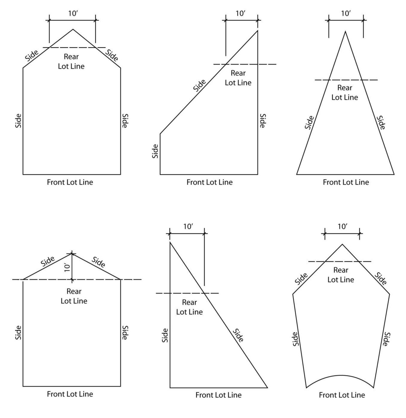
Figure 3-4
Rear Setback Areas on Irregularly Shaped Lots
C. Alternative Setback Area Location. In cases where the application of the setback area is not consistent with the character or general orientation of other lots in the vicinity, the Director may redefine the location of the front, side, and rear setback areas to be consistent with surrounding properties. The reorientation of setback areas is not applicable to the Bluff Overlay District and Canyon Overlay District.
D. Allowed Encroachments into Setback Areas. Encroachments into required setback areas are allowed in compliance with the standards in this subsection, except as provided in subsection (D)(1) of this section.
1. General Regulations.
a. Setbacks on Setback Maps. Notwithstanding any requirements in this section, all setback areas identified on the setback maps shall be regulated as front setback areas.
b. Overlay Districts. The encroachments allowed by this subsection shall not apply to designated bluff and canyon setback areas. Refer to Sections 21.28.040 (Bluff (B) Overlay District) and 21.28.050 (Canyon (C) Overlay District) for setback regulations and encroachments.
c. Alleys. No encroachments at the ground level are allowed within the required setback area of a lot abutting an alley. Rear setback areas abutting alleys shall be kept clear of obstructions.
d. Waterfront Areas. Allowed encroachments into required setback areas abutting or adjacent to the waterfront of Newport Bay, the shoreline of the Pacific Ocean, the Old Channel of the Santa Ana River (the Oxbow Loop), or the channels in West Newport shall not exceed a height of forty-two (42) inches above the existing grade.
e. Traffic Safety Visibility Areas. See Section 21.30.130 for restrictions on encroachments into traffic safety visibility areas.
2. Accessory Structures.
a. Accessory structures, including housings for mechanical equipment, not more than six feet in height and totaling no more than one hundred fifty (150) square feet per structure, may be located within a required side or rear setback area other than a rear setback area abutting an alley.
b. Arbors, trellises, and similar garden structures may be allowed to encroach into required front, side, and rear setback areas subject to the following limits:
i. The maximum footprint of the structure shall not exceed sixteen (16) square feet; and
ii. The maximum height of the structure shall not exceed nine feet.
c. Display areas for new motor vehicles associated with an allowed vehicle sales facility may encroach into a required front or street side setback area, provided a setback of at least two feet is maintained from the street adjacent property line.
d. Fences, hedges, and walls may be established within required setback areas in compliance with the requirements of Section 21.30.040 (Fences, Hedges, Walls, and Retaining Walls).
e. Decks, landings, patios, platforms, porches, steps, and terraces, and similar structures not more than eighteen (18) inches in height measured from the existing grade may be located within a required side or rear setback area other than those abutting an alley.
3. Architectural Features.
a. Roof overhangs, brackets, cornices, and eaves may encroach up to thirty (30) inches into a required front, side, or rear setback area, including required third floor front or rear setbacks; provided, that no architectural feature shall project closer than twenty-four (24) inches from a side property line and a minimum vertical clearance of at least eight feet above grade is maintained.
b. Decorative architectural features (e.g., belt courses, ornamental moldings, pilasters, and similar features) may encroach up to six inches into a required setback area.
4. Awnings and Canopies. Awnings and canopies may encroach into required setback areas up to a maximum of five feet subject to the following limits:
a. Residential Districts.
i. Front: one-half the depth of the required front setback area.
ii. Side: zero feet, except over doors up to twenty-four (24) inches from property line, maximum width shall not exceed the standard width of a door plus twelve (12) inches.
iii. Rear: two and one-half feet.
iv. Vertical clearance: six and one-half feet above grade.
b. Nonresidential Districts, including Mixed-Use Districts.
i. Front: one-half the depth of the required front setback area.
ii. Side: two feet.
iii. Rear: one-half the depth of the required rear setback area.
iv. Vertical clearance: eight feet above grade.
5. Balconies Abutting East Ocean Front and West Ocean Front.
a. Balconies may encroach up to a maximum of thirty-six (36) inches into a required front setback area along East Ocean Front and West Ocean Front. Balcony railings shall not exceed a maximum height of forty-two (42) inches and shall be constructed of either transparent material (except for supports) or opaque material (e.g., decorative grillwork, wrought iron, latticework, or similar open materials) so that at least forty (40) percent of the railing is open.
b. Balconies shall be cantilevered so that no underlying support is necessary. Roofs over balconies shall not be allowed to encroach into required front setback areas except as provided in subsection (D)(3) of this section (Architectural Features).
6. Bay Windows and Greenhouse Windows. Bay windows and greenhouse windows shall be allowed to encroach into required setback areas subject to the following limits:
a. No more than two bay windows or greenhouse windows shall be allowed to encroach into any one setback area;
b. Bay windows and greenhouse windows shall not exceed eight feet in width or ten (10) feet in height within the area of encroachment;
c. Bay windows and greenhouse windows shall be cantilevered and shall be designed to preclude use as a door or entry;
d. The exterior bottom surface of a bay window or greenhouse window shall be elevated a minimum of eighteen (18) inches above the adjacent finished interior floor surface at the required building setback line;
e. Encroachments into required setback areas shall be limited as follows:
|
Standard |
Allowed Encroachment |
Additional Regulations |
|---|---|---|
|
Front setback (4 ft. to less than 10 ft.): |
16 in. |
|
|
Front setback (10 ft. or more): |
2 ft. |
|
|
Side setback: |
2 ft. |
Limited to first floor only. The encroachment shall be at least twenty-four (24) inches from the side property line. |
|
Rear setback: |
2 ft. |
Not allowed when the rear property line abuts an alley. |
|
Distance between detached structures: |
2 ft. |
|
7. Fireplaces, Barbecues, and Chimneys—Attached.
a. Front and Rear Setback Area. Fireplaces, barbecues, and chimneys attached to the principal structure that are less than nine feet in width may encroach up to two feet into a required front or rear setback area that is ten (10) feet or greater in depth.
b. Side Setback Area. Fireplaces and chimneys attached to the principal structure that are less than nine feet in width may encroach up to thirty (30) inches into a required side setback area; provided, that the encroachment shall be at least twenty-four (24) inches from the side property line.
8. Fireplaces and Barbecues—Freestanding.
a. Front Setback Area. Freestanding fireplaces (gas only) and barbecues with a maximum height of forty-two (42) inches (not including the barbecue hood) shall be allowed to encroach into the required front setback area, provided the total length of the barbecue and counter does not exceed six feet.
b. Side and Rear Setback Area. Freestanding fireplaces (gas only) and barbecues with a maximum height of six feet shall be allowed to encroach into the required side or rear setback area, provided a minimum thirty-six (36) inch clear path of travel is maintained adjacent to any habitable structures.
9. Garages and Carports for Duplexes. Where three parking spaces are located in garages or carports across the rear of a lot that is less than thirty (30) feet ten (10) inches wide, one garage/carport wall or support may encroach into the side setback area subject to the following:
a. Distance to Property Line. The distance from the garage wall or carport support to the nearest side property line shall be not less than twenty-six (26) inches plus the amount that the width of the lot exceeds thirty (30) feet. The other side setback area shall have a clear passageway a minimum of thirty-six (36) inches wide, clear of any obstructions; and
b. Width of Garage/Carport. The width of each garage/carport shall not be greater than the minimum required by Section 21.40.070 (Development Standards for Parking Areas).
10. Basement Walls. Basement walls that are located completely below grade may encroach into a required setback area up to twelve (12) inches.
11. Light Standards. In nonresidential coastal zoning districts, light standards used in conjunction with the illumination of parking lots and walkways shall be allowed to encroach into a required setback area, provided all of the requirements of Section 21.30.070 (Outdoor Lighting) are complied with.
12. Protective Railing. Protective railings around balconies and windows required by the California Building Code may encroach up to six inches into a required setback area.
13. Second Stories Abutting Alleys. In residential districts having alleys to the rear of the lot or development site, a second story may be allowed to encroach into the required setback area subject to the following conditions and exclusions:
a. Encroachments shall not extend closer than seven and one-half feet to the center of any alley;
b. Encroachments shall not extend closer than two and one-half feet to the rear property line;
c. That portion of the building that encroaches into the required rear setback area shall have a minimum ground clearance of eight feet;
d. No encroachment shall be allowed on lots having a depth exceeding eighty-five (85) feet; and
e. No encroachment shall be allowed on corner lots located at the intersection of two ten (10) foot wide alleys.
14. Shoring. Permanent or temporary shoring may encroach into a required setback area, provided it is located completely below finished grade and at least twelve (12) inches from any property line.
15. Swimming Pools/Spas. Swimming pools, spas, and other similar devices/equipment that are placed directly upon the existing grade and are less than forty-two (42) inches in height may be located within a required front, side, or rear setback area other than those abutting an alley.
16. Accessory Dwelling Units. Accessory dwelling units may be established within required setback areas in compliance with the requirements of Section 21.48.200 (Accessory Dwelling Units). (Ord. 2019-1 § 3, 2019; Ord. 2016-19 § 9 (Exh. A)(part), 2016)
21.30.130 Traffic Safety Visibility Area.
A. Visibility at Corners of Intersections Required. Corner lots in all coastal zoning districts shall be developed in a manner that ensures visibility across the corners of the intersecting streets, alleys, and private driveways.
B. Traffic Safety Visibility Area Described. The traffic safety visibility area shall be described as a triangular-shaped area on a corner lot formed by measuring the prescribed distance from the intersection of the front and street side property lines, an intersecting alley, or an intersecting driveway and connecting the lines diagonally across the property making a triangular area. See Figure 3-5.
C. Area of Traffic Safety Visibility Area. The dimensions of a traffic safety visibility triangle shall be as follows and shall be subject to further review and approval of the City Traffic Engineer:
1. Standard intersection line of sight requirements shall apply at the intersection of public or private two street rights-of-way and at the intersections of commercial driveways and streets;
2. Fifteen (15) feet from the intersection of a public or private street right-of-way and an alley;
3. Ten (10) feet from the intersection of two alleys. See subsection (E) of this section; and
4. Five feet from the corner of an intersecting street right-of-way and a driveway.
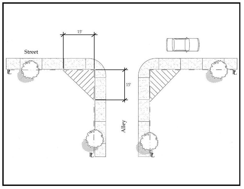
Figure 3-5
Traffic Safety Visibility Area
D. Height Limit. The following height limit requirements shall apply within a traffic safety visibility area:
1. Fences, walls, signs, accessory structures, mounds of earth, or other visual obstructions shall not extend above thirty (30) inches in height as measured from adjacent finished grade;
2. Hedges, shrubbery, and vegetation shall be maintained to a height of twenty-four (24) inches or less as measured from adjacent finished grade;
3. Only trees with single trunks are allowed and tree canopies shall be maintained at a minimum height of seven feet above ground level, as measured from adjacent street curb elevation.
E. Exemptions to Traffic Safety Visibility Height Limit.
1. Alleys. No above ground improvements (e.g., fences, walls, accessory structures, mounds of earth, vegetation and similar items) shall be allowed within the traffic safety visibility area required at the intersection of two alleys.
2. City Traffic Engineer Approval. Improvements, structures, or vegetation that exceed the allowed height limit for visibility in the traffic safety visibility area may be approved by the City Traffic Engineer if it is determined that the location and/or height of the existing or proposed hedge, shrubbery, structure, or other obstruction allows for the unobstructed view of oncoming traffic, bicyclists, and pedestrians by a driver approaching an intersection including those with private driveways. (Ord. 2016-19 § 9 (Exh. A)(part), 2016)
This standard shall not apply to development along Newport Bay with an existing bulkhead.