


Chapter 15.88
GRADING, EROSION AND SEDIMENT CONTROL
Sections:
15.88.050 Data and documents to accompany application.
15.88.060 Grading regulations.
15.88.070 Security/performance bond.
15.88.080 Permit approval, conditional approval or denial.
15.88.090 Permit duration, suspension, revocation or assignment.
15.88.100 Responsibility of permittee, permittee’s engineer and contractor.
15.88.170 Liability and property damage insurance.
15.88.180 Fines and penalties.
15.88.190 Severability and validity.
15.88.010 Purpose.
A. It is the declared intent of the city to promote the conservation of natural resources, including the natural beauties of the land, streams and watersheds, hills and vegetation; to protect public health and safety, including the reduction or elimination of the hazards of earth slides, mud flows, rock falls, undue settlement, erosion, siltation and flooding, or other special conditions as described in Government Code Section 54460(b); by minimizing the adverse effects of grading, cut and fill operations, water runoff and soil erosion. Therefore, the following regulatory provisions of this chapter are adopted for the purpose of stringent control of all aspects of grading operations within the city limits.
B. Any grading within the city limits shall conform to the provisions of this chapter, Chapter 15.80 PMC, Floodplain Management, and other applicable provisions of this code and to the latest edition of the city standard specifications and details. [Ord. 856 § 1, 1984.]
15.88.020 Definitions.
For the purposes of this chapter, the definitions listed under this section shall be construed as specified in this section:
“Applicant” means any person, corporation, partnership, association of any type, public agency or any other legal entity who submits an application to the city engineer for a permit pursuant to this chapter.
“Architect” means a professional architect registered in and by the state of California.
“As-graded” means the surface conditions extant on completion of grading.
“Bedrock” means in-place solid rock.
“Bench” means a relatively level stop excavated into earth material on which fill is to be placed, or within a cut or fill slope.
“Berm” means a built up mound of soil approximately one foot above grade or higher, all along the perimeter of a property, or the heel (top) of a slope to prevent water runoff from running onto adjacent property or eroding a slope.
“Best management practices” means a technique or series of techniques which, when used in an erosion control plan, is proven to be effective in controlling construction related runoff, erosion and sedimentation.
“Blending” means the intermixing and compaction of natural site soils, such as of materials from two natural soil horizons, or for the intermixing and compaction of natural site soils with imported soil or other materials.
“Borrow” means earth material acquired from an off-site location for use in grading on a site.
“Buttress fill” means a compacted fill which is placed in an area where soft natural soils beneath a planned fill would be over-stressed by the weight of the fill. The buttress fill is placed after the soft natural soils have been removed.
“Certification” means a written opinion concerning the progress and completion of the work, prepared by a registered civil engineer or geologist.
“City” means the city or designated official.
“City engineer” means the city engineer for the city or his authorized representative.
“Civil engineering” means the application of the knowledge of the forces of nature, principles of mechanics and the properties of materials to the evaluation, design and construction of civil works for the beneficial uses of mankind.
“Compaction” means the densification of a fill by mechanical means.
“Competent material” means earth material capable of withstanding the loads which are to be imposed upon it without failure to detrimental settlement, as certified by the soils engineer.
“Contour rounding” means the rounding of cut and fill slopes in the horizontal plane to blend with existing contours or to provide horizontal variation to eliminate the artificial appearance of slopes.
“Depth of cut or fill” means the vertical distance between existing natural ground and the finish elevation at any location.
“Drainageway” means natural or manmade channel which collects and intermittently or continuously conveys stormwater runoff.
“Earth material” means any rock, natural soil or fill and/or any combination thereof.
“Engineering geologist” means a professional engineering geologist registered in and by the state of California to practice in the field of engineering and geology.
“Engineering geology” means the application of geologic knowledge and principles in the investigation and evaluation of naturally occurring rock and soil for use in the design of civil works.
“Erosion” means the wearing away of the ground surface as a result of the movement of wind, water and/or ice.
“Excavation” means the mechanical removal of earth material.
“Existing grade” means the grade prior to grading.
“Fill” means a deposit of earth material placed by artificial means.
“Final erosion and sediment control plan (final plan)” means a set of best management practices or equivalent measures designed to control surface runoff and erosion and to retain sediment on a particular site after all other planned final structures and permanent improvements have been erected or installed.
“Finish grade” means the final grade of the site which conforms to the approved plan.
“Grade” means the vertical location of the ground surface.
“Grading” means any land disturbance, excavation or fill or any combination thereof.
“Height of cut and fill slopes” means the finished vertical distance from the top to toe of slope, measured prior to the application of any required slope rounding.
“Interim erosion and sediment control plan (interim plan)” means a set of best management practices or equivalent measures designed to control surface runoff and erosion and to retain sediment on a particular site during the period in which preconstruction and construction-related land disturbances, fills and soil storage occur, and before final improvements are completed.
“Key” means a designated compacted fill placed in a trench excavated in earth material beneath the top of a proposed fill slope.
“Land disturbance/land disturbing activities” means any moving or removing by manual or mechanical means of the soil mantle or top six inches of soil, whichever is more shallow, including, but not limited to, excavations.
“Land fill” means any activity depositing soil or other earth materials.
“Manual of standards” means a compilation of technical standards and design specifications adopted by the city engineer as being proven methods of controlling construction-related surface runoff, erosion and sedimentation.
“Modification” means any procedure that will reduce the Atterberg limits (liquid limit, plastic limit and Plasticity Index) of a soil.
“Nesting” means the placement of large rocks such that voids in the fill are created and that required compaction becomes difficult or impossible.
“Permittee” means the applicant in whose name a valid permit is duly issued pursuant to this chapter and his agents, employees and others acting under his direction.
“Replacement” means the removal and wasting of natural soil materials judged unsuitable for the support of dwellings or other site improvements and their replacement with suitable soil materials properly compacted.
“Reworking” means the mechanical densification or consolidation of natural loose soil material.
“Rough grade” means the stage at which the grade approximately conforms to the approved plan.
“Sediment” means earth material deposited by water or wind.
“Site” means any lot or parcel of land or contiguous combination thereof, where grading is performed or permitted.
“Slope” means an inclined ground surface, the inclination of which is expressed as a ratio of horizontal distance to vertical distance.
“Slope control specialist” means a professional landscape architect or other professional person experienced in erosion control work, retained by the developer in a professional or consultative capacity (not as a contractor performing construction work in the development) and responsible for analysis, plans, specifications, supervision and certifications regarding slope control planting and related slope control work, other than grading, for a specific project.
“Soil” means the top layer of the earth’s surface, excluding rock.
“Soil engineering” means the application of the principles of soil mechanics in the investigation, evaluation and design of civil works involving the use of earth materials and the inspection and testing of the construction thereof.
“Soils engineer” means a civil engineer licensed in the state of California, experienced and knowledgeable in the practice of soil engineering.
“Stabilization” means any procedure that will result in increased strength of a soil to a required level.
“Terrace” means a relatively level step constructed in the face of a graded slope surface for drainage and maintenance purposes.
“Variable slope” means the variation in steepness of a cut or fill slope in either, or a combination of, the horizontal or vertical plane of the slope.
“Vertical slope rounding” means the rounding of the tops or toes of cut and fill slopes.
“Wet season” means the period from October 15th to April 15th. [Ord. 856 § 1, 1984.]
15.88.030 Permit required.
A. No person may grade, fill, excavate or store or dispose of soil and earth materials or perform any other land-disturbing or land-filling activity without first obtaining a permit as set forth in this chapter.
No permit shall be granted until the applicant has obtained approval of all his legislative requirements, such as, but not limited to, use permits, hillside planned development permit, tentative map, building permit or site plan review, where required. The environmental impact report shall be considered in the granting of a permit, and conditions may be imposed by the city to minimize or mitigate the negative environmental impacts of the proposed work.
B. All land-disturbing or land-filling activities or soil storage shall be undertaken in a manner designed to minimize surface runoff, erosion and sedimentation. A person performing such activities need not apply for a permit pursuant to this chapter, if all the following criteria are met:
1. The site upon which land area is disturbed or filled is 10,000 square feet or less;
2. Natural and finished slopes are less than 10 percent;
3. Volume of soil or earth materials disturbed or stored is 50 cubic yards or less;
4. Rainwater runoff is diverted, either during or after construction, by the activities from an area smaller than 5,000 square feet;
5. An impervious surface, if any, of less than 5,000 square feet is created;
6. No drainageway is blocked or has its stormwater carrying capacities or characteristics modified;
7. The activity does not take place within 50 feet, by horizontal measurement, from the top of the bank of a watercourse, the mean high water mark (line of vegetation) of a body of water or within the wetlands associated with a watercourse or water body, whichever distance is greater.
C. Subsections (A) and (B)(1) through (6) of this section notwithstanding, the following activities are always categorically exempt from the permit requirements:
1. An excavation below finished grade for basements and footings of a building, retaining wall or other structure authorized by a valid building permit. This shall not exempt any fill made with material from such excavation nor exempt any excavation having an unsupported height greater than five feet after the completion of the structure;
2. Cemetery graves;
3. Refuse disposal sites meeting regional water quality control board waste discharge requirements and in compliance with other regulations;
4. Excavations for wells or tunnels;
5. Mining, quarrying, excavating, processing, stockpiling of rock, sand, gravel, aggregate or clay where a valid use permit from the city is in effect and regional water quality control board waste discharge requirements are met and there is compliance with other regulations, also provided such operations do not affect the lateral support or increase the stresses in or pressure upon any adjacent or contiguous property;
6. Exploratory excavations under the direction of soils engineers or engineering geologists;
7. Agricultural use of land that is operated in accordance with a conservation plan approved by the resource conservation district (RCD) or when it is determined by the RCD that such use will not cause excessive erosion or sediment losses, provided:
a. Cut or fills do not exceed three feet in depth, and
b. Cut or fill slopes are no steeper than two to one;
8. Subsection (B)(7) of this section notwithstanding, any activity where total volume of material disturbed, stored, disposed of or used as fill does not exceed 25 cubic yards is always categorically exempt from the permit requirements;
9. Work conducted in any city street, public right-of-way or easement when the work is for a public facility, public utility or other public purpose and for which an encroachment permit has been issued;
10. City public works projects;
11. Emergency work authorized by the city necessary to protect life, limb or property, or to maintain the safety, use or stability of a public way or drainage way. [Ord. 856 § 1, 1984.]
15.88.040 Permit application.
To obtain a permit the applicant shall first file a written application on a form approved by the city engineer containing no less than the following information:
A. Name, address and telephone number of the applicant;
B. Names, addresses and telephone numbers of any and all contractors, subcontractors or persons actually doing the land-disturbing and land-filling activities and their respective tasks;
C. Names, addresses and telephone numbers of the person(s) responsible for the preparation of the site map and grading plan;
D. Names, addresses and telephone numbers of the person(s) responsible for the preparation of the interim and/or final erosion and sediment control plan;
E. Name, address and telephone number of the registered geologist responsible for the preparation of the soils and geological report, where required;
F. An estimate of the time schedule of work;
G. The city business license number of the contractor performing the work;
H. Date of application;
I. Signature(s) of the owner(s) of the site or of an authorized representative;
J. Description of site location. [Ord. 856 § 1, 1984.]
15.88.050 Data and documents to accompany application.
The application shall be accompanied by not less than the following material:
A. General Plans and Data.
1. Application form;
2. Site map and grading plan;
3. Interim erosion and sediment control plan;
4. Final erosion and sediment control plan, where required;
5. Soils engineering report, where required;
6. Geology engineering report, where required;
7. Work schedule;
8. An engineer’s estimate of the quantity and cost of the work to be done;
9. Ten percent cash bond or certificate of deposit;
10. Any supplementary material required by the city engineer;
11. Application fees (inspection and plan checking fees shall be paid in accordance with PMC 12.01.170(B) and (C)).
B. Specific Plans and Data.
1. Grading Plan and Site Map. Plans shall be 24 inches by 36 inches and to a form approved by the city engineer. The plans shall contain the following items, plus any additional material which the city engineer deems necessary to show conformance of the proposed grading with the requirements of this section and other related ordinances. They shall contain:
a. A vicinity map showing the location of the site in relationship to the surrounding area’s watercourses, water bodies and other significant geographic features, and roads and other significant structures;
b. Boundary lines of the site;
c. Each lot or parcel of land into which the site is proposed to be divided;
d. The location of any existing buildings or structures on the property where the work is to be performed, and the location of any buildings or structures on adjacent land within 100 feet of the proposed work;
e. Accurate contours showing the topography of the existing ground extending at least 100 feet outside all boundary lines of the site, or sufficient to show on-site and off-site drainage;
f. Elevations, locations, cross-sections, extent and slope of all proposed grading shown by contours, or other acceptable means and location of any rock disposal areas, buttress fills, subdrains or other special features to be included in the work;
g. Detailed plans of all surface and subsurface drainage systems and facilities, walls, cribbing or other erosion protection devices to be constructed in connection with, or as part of the proposed work, together with a map showing the draining area and estimated runoff of the area served by any drainage systems or facilities;
h. The location, circumference, species and approximate elevation at the base of all trees, as defined in PMC 12.32.020. The design of the plans shall attempt to save wherever possible trees and other natural features of high aesthetic value. A tree care specialist shall review the trees to be saved at the site for physical condition and prepare a report setting requirements of grading and development adjacent to the saved trees. These requirements shall be incorporated into the grading plan;
i. Location and graphic representation of all existing and proposed natural and manmade drainage facilities;
j. Location of proposed final surface runoff, erosion and sediment control measures;
k. A statement of the quantities of material to be excavated and/or filled and the amount of such material to be imported to, or exported from, the site;
l. Outline of the methods to be used in clearing vegetation, and in storing and disposing of the cleared vegetative matter;
m. Proposed sequence and schedule of excavation filling, and other land-disturbing and filling activities, and soils or earthen material storage and disposal;
n. Location of any buildings or structures on the property where the work is to be performed and the location of any buildings or structures on land of adjacent owners which are within 15 feet of the property or which may be affected by the proposed grading operations;
o. Indication of 100-year storm frequency flood boundary as defined by Chapter 15.80 PMC, if applicable.
2. Interim Erosion and Sediment Control Plan (Interim Plan). All the following information shall be provided with respect to conditions existing on the site during land-disturbing or filling activities or soil storage:
a. Maximum surface runoff from the site shall be calculated using methods approved by the Contra Costa flood control district;
b. A delineation and brief description of the measures to be undertaken to retain sediment on the site, including, but not limited to, the designs and specifications for berms and sediment detention basins and a schedule for their maintenance and upkeep;
c. A delineation and brief description of the surface runoff and erosion control measures to be implemented, including, but not limited to, types and method of applying mulches, and designs and specifications for diverters, dikes and drains, and a schedule for their maintenance and upkeep;
d. A delineation and brief description of the vegetative measures to be taken, including, but not limited to, seeding methods, the type, location and extent of preexisting and undisturbed vegetation types, and a schedule for maintenance and upkeep;
e. The location of all the measures listed by the applicant under subsection (B)(2)(b) of this section shall be depicted on the site map and/or grading plan;
f. An estimate of the cost of implementing and maintaining all interim erosion and sediment control measures must be submitted in a form acceptable to the city engineer;
g. The applicant may propose the use of any erosion and sediment control techniques in the interim plan provided such techniques are proven to be as or more effective than the equivalent best management practices contained in the manual of standards;
h. The requirements for the interim plan may be waived by the city engineer; provided, that:
i. The average ground slope of the site is less than 10 percent,
ii. The total area of the site is less than one acre,
iii. The site will be totally built upon and landscaped upon completion, and
iv. No adverse erosion or sediment impacts are likely to occur as a result of the development.
3. Final Erosion and Sediment Control Plan (Final Plan). All the following information shall be provided with respect to conditions existing on the site after final structures and improvements (except those required under this section) have been completed and where these final structures have not been covered by an interim plan:
a. A description of and specifications for sediment retention devices;
b. A description of and specifications for surface runoff and erosion control devices;
c. A description of vegetative measures;
d. The location of proposed final surface runoff, erosion and sediment control measures;
e. A graphic representation of the location of all items in subsections (B)(3)(a) through (c) of this section;
f. An estimate of the costs of implementing all final erosion and sediment control measures must be submitted in a form acceptable to the city engineer;
g. Maximum runoff from the site shall be calculated using Contra Costa Flood Control District methods, the method in the manual, or any other method approved by the city engineer;
h. A complete and detailed specification shall be prepared by an erosion and sediment control specialist. The specification shall indicate the material and methods for slope control planting, including ground covers, trees and shrubs, with special emphasis on the following:
i. Soil preparation, fertilization, plant material and methods of planting,
ii. Initial maintenance of the plant material and slopes until a specified percentage of plan coverage is established uniformly on the cut and fill slopes,
iii. Minimizing erosion and sedimentation;
i. The specifications shall include a statement by the slope control specialist giving a professional opinion regarding the following:
i. The length of time after planting in which the specified planting with the specified initial maintenance will normally produce, on the slopes in the slope control areas, the specified percentage of plant coverage,
ii. The length of time in which this specified plant coverage, without any special additional maintenance, will normally produce a coverage of permanent planting which will control erosion;
j. The applicant may propose the use of any erosion and sediment control techniques in the final plan provided such techniques are proven to be as or more effective than the equivalent best management practices contained in the manual of standards;
k. No final plan will be required where an interim plan requirement has been waived.
4. Soils and Engineering Geology Report. The soils and geology report required in this chapter shall be prepared by a professional soil investigation firm under the direction of a registered soils engineer and an engineering geologist.
a. Sufficient soil samples to represent a true cross-section of the cut and fill areas and of the material to be used as fill shall be taken and tested under the supervision of the soils engineer. All soils shall be classified in accordance with the Unified Soil Classification system. Reports, including all test reports by the soils engineer and geologist, shall be submitted covering the following:
i. An adequate description of the geology of the site,
ii. Conclusions and recommendations regarding the effect of geologic conditions on the proposed development,
iii. The location and effects of active faults which may affect the proposed development. The results of seismic activity on the soils as the site is proposed to be graded and on the proposed buildings to be evaluated. Recommendations shall be made relating to building distances from nearby active faults and foundation design due to seismic activity,
iv. Data regarding the nature, distribution, strength, expansive quality and erodibility of existing soils,
v. Data regarding the nature, distribution, strength and erodibility of soils to be placed on the site, if any,
vi. Conclusions and recommendations for grading procedures,
vii. Conclusions and recommended designs for interim soil stabilization devices and measures and for permanent soil stabilization after construction is completed,
viii. Design criteria for corrective measures when necessary,
ix. Opinions and recommendations covering adequacy of sites to be developed by the proposed grading,
x. Any potential ground water condition which may affect soil strength, consolidation or slope stability shall be defined and evaluated. This is of particular importance in areas subject to vibratory or shock loadings;
b. A complete and detailed specification shall be prepared by the soils engineer for clearing, grubbing, and all aspects of grading, including utility trench backfill, with special emphasis on the depth of fill layers, compaction methods, moisture content, frequency of field density tests, and minimum density to be obtained in the field as related to laboratory density tests;
c. A statement regarding specified grading and slopes shall be prepared by the soils engineer, giving professional opinion including the following:
i. Shrinkage or settlement of a fill constructed in compliance with the proposed specification for controlled earthwork,
ii. The safe load-bearing capacity of such controlled sites,
iii. The maximum slope ratios necessary for slope stability for proposed fill and cut slopes, with recommended planting on the slope to assure freedom from erosion,
iv. The remaining movement, if any, anticipated in cut areas. Any forecast of appreciable settlement shall be supported by appropriate site soils data;
d. Recommendations included in this report and approved by the city shall be incorporated in the grading plans and/or specifications;
e. All or portions of this requirement may be waived by the city engineer; provided, that:
i. The average ground slope of the site is less than 10 percent,
ii. The total site area is less than 10,000 square feet, and
iii. There are no known geologic hazards on or adjacent to the site;
f. The city reserves the right to require additional soils and/or geologic investigations be made if it deems necessary in order to further ensure the safety and maintainability of the site.
5. Work Schedule. The applicant must submit a master work schedule showing the following information:
a. Proposed grading schedule;
b. Proposed conditions of the site on each September 15th and October 15th during which the permit is in effect;
c. Proposed schedule for installation of all interim erosion and sediment control measures, including, but not limited to, the stage of completion of erosion and sediment control devices and vegetative measures on each of the dates set forth in subsection (B)(5)(b) of this section;
d. Schedule of construction of final improvements, if any;
e. Schedule for installation of permanent erosion and sediment control devices, where required. [Ord. 856 § 1, 1984.]
15.88.060 Grading regulations.
A. General.
1. Grading shall be designed, as far as possible, so that lot lines are at the top of slope and with adequate property line setback from the slope to provide for required vertical slope rounding.
2. Grading shall be designed wherever possible to be at the same elevation or below adjoining properties outside the development so as not to negate the privacy of the adjoining property owners. If it is not possible and there are adjoining properties which will be adversely affected, the developer shall be required to either move the slope onto the adjacent property owner’s land replacing fences and improvements or replace the property owner’s fence (if one exists) at the top of the slope and deed the slope to the property owner. The city may waive this requirement wherein the adversely affected property owner fails to negotiate for either option.
3. Stockpiling of materials shall be subject to city approval and shall be removed or relocated when required for public health or safety.
4. All graded surfaces and materials, whether filled, excavated, transported or stockpiled, shall be wetted, protected or contained in such a manner as to prevent any nuisance from dust, or spillage upon adjoining property or streets. Equipment and materials on the site should be used in such a manner as to avoid excessive dust.
5. All grading and noise therefrom, including, but not limited to, warming of equipment motors in residential zones, or within 1,000 feet of any residential occupancy, hotel, motel or hospital shall be limited between the hours of 7:00 a.m. and 5:30 p.m. weekdays, unless other hours are approved by the city engineer, upon receipt of evidence that an emergency exists which would constitute a hazard to persons or property.
6. Whenever any portion of the work requires entry onto adjacent property for any reason, the permit applicant shall obtain a right of entry from the adjacent property owner or his authorized representative in a form acceptable to the city, and shall file a copy of the fully executed right of entry with the city prior to issuance of the grading permit and/or approval of the grading plans.
B. Setbacks.
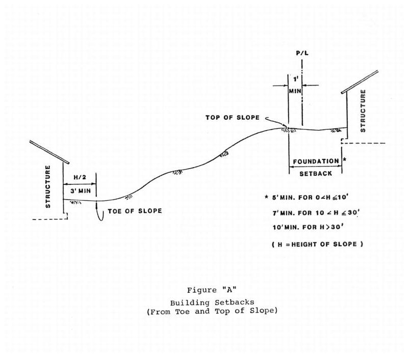
1. The tops and toes of cut and fill slopes shall be set back from property lines and structures as far as necessary to provide for safety of adjacent property, safety of pedestrians and vehicular traffic, required slope rounding, adequate foundation support, required swales, berms and drainage facilities and applicable zoning requirements. Except for pier-type foundations or other special foundation design, setbacks shall be not less than shown in Figure “A.”
2. The setbacks and other restrictions specified by this section are minimum and may be increased by the building official or by the recommendations of a civil engineer, soils engineer or engineering geologist, if necessary, for safety and stability or to prevent damage of adjacent properties from deposition or erosion or to provide access for slope maintenance and drainage. Retaining walls may be used to reduce the required setbacks when approved by the building official.
C. Preparation of Ground. The ground surface shall be prepared to receive fill by removing vegetation, noncomplying fill, topsoil and other unsuitable materials scarifying to provide a bond with the new fill, and where slopes are steeper than five to one, and the height is greater than five feet, by benching into sound bedrock or other competent material as determined by the soils engineer. The bench under the toe of a fill on a slope steeper than five to one shall be at least 10 feet wide. The area beyond the toe of fill shall be sloped for sheet overflow or a paved drain shall be provided. Where fill is to be placed over a cut, the bench under the toe of fill shall be at least 10 feet wide, but the cut must be made before placing fill and approved by the soils engineer and engineering geologist as suitable foundation for fill. Unsuitable soil is soil which, in the opinion of the city or the civil engineer or the soils engineer or the geologist, is not competent to support other soil or fill, to support structures or to satisfactorily perform the other functions for which the soil is intended.
D. Cut and Fill Slopes.
1. Cut and fill slopes shall be in general, no steeper than is safe for the intended use or is necessary to ensure the protection and safety of adjacent properties.
2. Unless recommended otherwise by the soils engineer, and approved by the city, the steepness of cut or fill slopes shall not exceed two horizontal to one vertical.
3. The height of cut and fill slopes (including retaining walls) and the maximum depth of cut or fill shall not exceed that which is shown on the approved hillside planned development permit.
4. Guidelines for vertical slope rounding shall be in accordance with details as approved by the city engineer.
5. Cut and fill slopes shall be contour rounded as approved by the city during the various stages of approval.
6. Variable slopes shall be used to mitigate environmental and visual impacts of grading.
7. Cut and fill slopes shall be provided with subsurface drainage as necessary for stability.
E. Excavations and Embankments.
1. General.
a. Excavations and embankments, in general, shall conform to the latest edition of the city’s standard specifications and as required herein.
b. Cut and fills shall be designed to balance as near as possible to avoid the nuisances created by off-site hauling. If off-site hauling is determined necessary by the city, details of the hauling operation, including, but not limited to, size of trucks, haul route, dust and debris control measures and time and frequency of haul trips shall be submitted to the city for approval. The city shall be empowered to place such restrictions as it deems necessary to minimize health, safety and general welfare problems which might arise from this hauling.
c. Fill slopes shall not be constructed on natural slopes steeper than two horizontal to one vertical.
d. All fills shall be compacted to a minimum of 90 percent of maximum density as determined by the State Impact Method Test No. 216F or equivalent method approved by the city of determining maximum soil density. Field density shall be determined by a method acceptable to the city.
2. Fill Material.
a. Detrimental amounts of organic material shall not be permitted in fills. Except as permitted by the building official, no rock or similar irreducible material with a maximum dimension greater than 12 inches shall be buried or placed in fills.
b. The city may permit placement of larger rock when the soils engineer properly devises a method of placement, continuously inspects its placement and approves the fill stability. The following conditions shall also apply:
i. Prior to issuance of the grading permit, potential rock disposal areas shall be delineated on the grading plan;
ii. Rock sizes greater than 12 inches in maximum dimension shall be 10 feet or more below grade, measured vertically;
iii. Rock shall be placed so as to assure filling of all voids with fine soils.
F. Erosion and Sediment Control.
1. Erosion and sediment control measures shall be implemented as specified by the approved interim and final sediment and erosion control plans. Erosion and sediment control measures shall be consistent with the Manual of Sediment and Erosion Control Practices and Best Management Practices.
2. No grading shall be conducted as to cause erosion or flooding of any natural drainage way.
3. Sediment basins, as required by the interim and final erosion and sediment control plans, shall be constructed to detain runoff and trap sediment. Temporary sediment basin dams and collected silt shall then be removed and the resulting material hauled from the site or used as topsoil.
4. The faces of cut and fill slopes shall be prepared and maintained to control against erosion and to return the slope to its natural appearance as near as possible. The protection for the slopes shall be installed as soon as practicable and prior to calling for final approval. The planting shall be so timed that ground covers will not be washed out by rains nor burned due to lack of water. Where necessary, check dams, cribbing, rip rap and other devices or methods shall be employed to control erosion and to provide safety.
5. All exposed or finished banks or slopes of any fill or excavation shall be protected from erosion by approved planting, irrigation, hydroseeding, cribbing, walls or terracing or a combination thereof. All graded surfaces exceeding 5,000 square feet in area shall be planted and irrigated, paved or built upon and shall be provided with berms and approved drainage facilities adequate to prevent erosion and to conduct the accumulation of runoff of surface waters to an approved place of discharge. It is the intent of this section to prohibit the abandonment of graded areas or slopes which are not provided with erosion protection and adequate drainage facilities, even though all other requirements in this section have been provided and approved.
G. Drainage.
1. General.
a. All drainage facilities shall be designed to carry waters to the nearest practicable drainageway approved by the city and/or other appropriate jurisdiction as a safe place to deposit such waters. Erosion of ground in the area of discharge shall be prevented by installation of nonerosive downdrain or other devices.
b. All building sites shall be graded and sloped away from the building foundation with a minimum slope of two percent for a distance of 10 feet on all sides of every building, except where yard requirements are less than 20 feet, in which case the soil shall be graded away from the foundation to a minimum of two-tenths of one foot in elevation at a distance not less than one-half the required yard width.
c. Lot drainage shall be directed toward approved drainage facilities at a minimum gradient of one and one-half percent. The gradient from the building pad may be one percent if all the following conditions exist throughout the building area:
i. No proposed fills are greater than 10 feet in maximum depth;
ii. No proposed finish cut or fill slope faces have a vertical height in excess of 10 feet;
iii. No existing slope faces have a slope face steeper than 10 horizontal to one vertical.
2. Terraces.
a. Terraces at least six feet in width shall be established at not more than 30-foot vertical intervals to control surface drainage and debris on cut or fill slopes. For cut or fill slopes greater than 60 feet and up to 120 feet in vertical height, one terrace at approximately mid-height shall be 12 feet in width. Terrace widths and spacing for cut and fill slopes greater than 120 feet in height shall be designed by the civil engineer and approved by the city.
b. Suitable access shall be provided to permit proper cleaning and maintenance.
3. Interceptor Ditches.
a. Interceptor ditches shall be installed where necessary to protect slopes from surface runoff. They shall be designed for the anticipated runoff from a 25-year design storm and paved with portland cement to a minimum three-inch thickness and a 32-inch top width. The minimum depth at the center shall be one foot or as required for a minimum of three-inch free board during the 25-year design storm.
b. The minimum gradient of interceptor ditches shall be one percent and no single run shall collect runoff from a tributary area exceeding 15,000 square feet (horizontal projection) without discharging into an approved down drain.
4. Trash Racks. Properly designed trash racks shall be installed on the upstream end of storm drain pipes where that pipe accepts drainage from a waterway which is not to be undergrounded. These racks are to be constructed so as to preclude large debris and small children from being pulled into the pipe from heavy storm flows. The city may require the installation of trash racks at other locations as deemed necessary for proper maintenance and safety.
H. Wet Season Work.
1. For commencement of the activity during the wet season, the applicant shall demonstrate to the satisfaction of the city engineer, that land disturbance is relatively minor and that erosion and sedimentation can be controlled.
2. For continuation of activities, other than installation, maintenance or repair of measures in the interim or final plans, during the wet season, the permittee must apply for and receive, every five working days, special permission to proceed. The request shall be accompanied by a recommendation from the soils engineer for continuation of the work.
3. The city engineer may grant permission under this section on the basis of weather forecasts, recommendation of the soils engineer, experience and other pertinent factors which indicate the activity may commence or continue without erosion and/or sedimentation occurring.
4. The applicant/permittee’s failure to obtain permission for wet season activity shall result in the imposition of suspension/revocation, and action against the security or criminal penalties as described herein.
5. The city engineer may prohibit the activity during the months in which he/she finds that rainfall will likely preclude compliance with these recommendations.
I. Modifications.
1. Modifications to the specific grading regulations in this section may be approved or required by the city upon finding that such modification:
a. Is necessary to preserve existing natural features, such as trees, streams, hills, significant vegetation or rock outcroppings, etc.; or
b. Will reduce the adverse visual impacts of cut and fill operations.
2. For subdivisions of five or more units, this finding must be made by the planning commission and/or the city council at the time of approval of the tentative map or hillside planned development permit.
3. For all other grading where a grading permit is required, the finding must be made by the city engineer.
4. When a soils report is required for the proposed grading, the modifications shall be subject to approval by the soils engineer. [Ord. 856 § 1, 1984.]
15.88.070 Security/performance bond.
A. Amount and Form of Security.
1. The applicant shall provide security for the performance of the work described and delineated on the approved grading plan and interim and final erosion and sediment control plans in an amount not less than 10 percent of the total estimated cost of the work. The estimated cost of work shall be as approved by the city engineer.
2. The type of security shall be either:
a. Cash deposit with the city; or
b. A certificate of deposit approved by the city attorney from a financial institution subject to regulation by the state or federal government wherein said financial institution pledges funds are on deposit and guaranteed for payment, and payable, immediately, partially or in full, to the city upon demand.
B. Action Against Security.
1. Should the city find that the permittee has failed to comply with any of the following or should any of the following conditions exist, the city engineer may take appropriate action against the security after giving written notice to the permittee and surety.
a. The permittee ceases land-disturbing activities and/or filling and abandons the worksite prior to completion of the work;
b. The permittee fails to conform to the approved interim or final erosion and sediment control plans;
c. The permittee fails to correct a hazardous condition, to remedy defective work or repair damage caused by the work;
d. The permittee fails to conform to the approved grading plan and/or any condition of approval.
2. The written notice to the permittee and surety by the city engineer shall include:
a. The work to be completed and/or repairs to be made;
b. The approximate cost to perform the required work;
c. The time in which all work is to be completed.
3. Should the required work not be completed within the time specified by the city, the city may cause such work to be completed or partially completed to a condition acceptable to the city, and deduct the cost thereof from any cash deposit or collect such amount from the surety.
C. Release of Surety. Any unused security posted with the city for faithful performance shall be released as follows:
1. Eighty percent of the unused security will be returned upon completion and acceptance of the work by the city engineer (less any outstanding claims); and
2. Any remainder of the security will be released 12 months after completion and acceptance by the city engineer provided all defective work is corrected to the satisfaction of the city engineer. [Ord. 856 § 1, 1984.]
15.88.080 Permit approval, conditional approval or denial.
A. General. No permit shall be approved or issued until all required plans, reports, documents and security have been submitted and approved by the city engineer and all fees have been paid.
B. Action By the City Engineer.
1. The city engineer, or authorized representative, shall review all plans and documents submitted pursuant to this chapter and, if necessary, request additional data, clarification of submitted data or correction of defective submissions within 20 working days after the date of submission. The city engineer shall notify the applicant in writing of his approval, conditional approval or denial of the permit application within 30 calendar days of the initial submission or of the corrected submissions, whichever is later.
2. In the case of subdivisions, the approval to proceed by the city engineer, after having signed grading plans and having received all required bonds, fees, agreements and deeds, shall constitute the issuance of a grading permit. Grading shall be defined as an improvement for the purpose of the subdivision improvement agreement. [Ord. 856 § 1, 1984.]
15.88.090 Permit duration, suspension, revocation or assignment.
A. Duration of Permit.
1. Permits issued under this chapter shall be valid for the period specified on the permit form, or as specified by an improvement agreement.
2. Should grading not commence within 60 calendar days of the time specified on the permit, the city engineer may void the permit and require a reapplication for issuance of a new permit.
3. The city engineer may grant an extension of time upon just showing by the permittee. The city engineer may require additional fees or reasonable conditions in consideration for such time extension.
B. Suspension or Revocation of Permit.
1. General. The city engineer shall first resort to the procedures set forth in this section before any other enforcement procedure set forth in this chapter is implemented.
2. Suspension.
a. The city engineer shall suspend the permit and issue a stop work order, and the permittee shall cease all work on the work site, except work necessary to remedy the cause of the suspension, upon notification of such suspension when:
i. The city engineer determines that the permit was issued in error or on the basis of incorrect information supplied, or in violation of any ordinance or regulation or the provisions of this chapter; or
ii. The permittee fails to submit reports where required; or
iii. The work on site is not being performed in accordance with approved plans and specifications; or
iv. The permittee fails to comply with an order to modify the work within the time limits imposed by the city engineer; or
v. The permittee fails to obtain permission for wet season activity; or
vi. The permittee is causing excessive erosion and/or sediment.
b. The city engineer may reinstate a suspended permit upon the permittee’s correction of the cause of the suspension.
3. Revocation.
a. The city engineer may revoke the permit and issue a stop work order upon finding the permittee:
i. Conducts or carries on the grading in such a manner as to materially affect adversely the health, welfare or safety of persons residing or working in the neighborhood of the property of the permittee; or
ii. Conducts or carries on the grading so that the grading is materially detrimental to the public welfare or injurious to property or improvements in the neighborhood; or
iii. Fails to cease work under an order of suspension.
b. Any revocation will be effective immediately upon notification by the city engineer. The city engineer shall not reinstate a revoked permit.
C. Assignment of Permit. A permit issued pursuant to this chapter may be assigned, provided:
1. The permittee notifies the city engineer of the proposed assignment;
2. The proposed assignee:
a. Submits an application form, and
b. Agrees in writing to all the conditions and duties imposed by the permit, and
c. Agrees in writing to assume responsibility for all work performed prior to the assignment, and
d. Provides the necessary security/performance bond(s), and
e. Agrees to pay all applicable fees;
3. The city engineer approves the assignment. [Ord. 856 § 1, 1984.]
15.88.100 Responsibility of permittee, permittee’s engineer and contractor.
A. Permittee/Contractor.
1. The permittee and/or the permittee’s engineers, contractors or agents shall be responsible for the satisfactory and safe conduct of all work.
2. The permit applicant and grading contractor shall be responsible for the protection of adjacent properties during grading operations. Prior to commencing any grading of the site, the exterior boundaries shall be marked as required by the city engineer. Boundary markers shall be maintained throughout the grading operation. Temporary barriers and/or protective fencing shall be used when necessary to protect adjacent properties.
3. In addition to the security to be posted in accordance with PMC 15.88.070, the applicant shall agree to employ a civil engineer, soils engineer and/or engineering geologist to give technical supervision or make inspections of the work whenever a soils report has been required for the proposed grading.
4. The permittee shall maintain a copy of the permit, approved plans and reports on the worksite and available for inspection by the city engineer during all working hours.
5. The permittee shall, at all times, be in conformity with approved site map and grading plan and interim and final plans.
6. Unless waived by the city engineer, the permittee shall notify the city engineer within 36 hours of the following:
a. The beginning of the permitted activity;
b. The completion of rough grading;
c. The completion of finished grading;
d. The installation of all erosion control devices and the completion of planting requirements; and
e. The readiness of the site for final inspection, including, but not limited to, finished grading, installation of drainage devices and final erosion control measures.
7. The permittee shall submit to the city engineer written reports if:
a. There are any delays in obtaining materials, machinery, services or manpower necessary to the implementation of the grading and interim of final plans as scheduled;
b. There are any delays in land-disturbing or filling activities or soil storage;
c. The work is not being done in conformance with the approved grading plan or interim or final plans;
d. There are any departures from the approved grading plan which may affect implementation of the interim or final plans as schedules;
e. There are any delays in the implementation of the interim or final plans; or
f. There are any other departures from implementation of the interim or final plans.
8. Unless this requirement is waived by the city engineer, the permittee shall submit recommendations for corrective measures, if necessary and appropriate, with the reports.
9. The city will review all reports submitted by the permittee. The city engineer may require the permittee to modify the site map and grading plan, interim or final plans, and maintenance methods and schedules. The city engineer shall notify the permittee in writing of the requirement and specify a reasonable period of time within which the permittee must comply. All modifications are subject to the city engineer’s approval.
B. Soils Engineer.
1. The soils engineer’s area of responsibility shall include, but need not be limited to, the professional inspection and certification concerning the preparation of ground to receive fills, testing for required compaction, stability of all finish slopes and design of buttress fills and the design and need for subdrains and other ground water control devices, where required, incorporating data supplied by the engineering geologist.
2. Upon completion of the grading, the soils engineer shall certify that the site was graded and filled with material in accordance with the approved specifications. He shall also give his professional opinion regarding remaining shrinkage or settlement, expansive characteristics, slope stability, load-bearing qualities, saline or alkaline conditions, and of any other conditions pertinent to construction upon the completed cut or fill.
C. Civil Engineer.
1. It shall be the responsibility of the civil engineer who prepared the approved grading plans to incorporate all recommendations from the soils engineer and engineering geology reports into the grading plan. He shall also be responsible for the professional inspection and certification of the grading within his area of technical specialty. The civil engineer shall act as the coordinating agent in the event the need arises for liaison between the other professionals, the contractor and the city. The civil engineer shall also be responsible for the preparation of revised plans and the submission of as-graded plans upon completion of the work.
2. Prior to foundation work, the permittee’s engineer shall certify that the building pad elevations do not vary more than two-tenths of one foot from the approved pad elevations.
3. When work has been completed, all drainage devices, systems and facilities installed and slope planting established, the civil engineer shall certify that all grading, lot drainage and drainage facilities have been completed and the slope planting installed in conformance with the approved plans and the requirements of this chapter.
D. Engineering Geologist. The engineering geologist’s area of responsibility shall include, but is not necessarily limited to, professional inspection and certification of the adequacy of natural ground for receiving fills and the stability of cut slopes with respect to geological matters. He shall report his findings to the soils engineer and the civil engineer for engineering analysis.
E. Slope Control Specialist. The slope control specialist’s area of responsibility shall include, but is not necessarily limited to, professional design and inspection of erosion control measures and the certification of the completion and adequacy therefor. [Ord. 856 § 1, 1984.]
15.88.110 Inspection.
A. General.
1. All grading operations for which a permit is required shall be subject to inspection by the city.
2. The city, upon at least 36 hours’ prior notification from the permittee or his agent, shall inspect the work at the following stages of the work and shall either approve the portion then completed, or shall notify the permittee or his agent wherein it fails to comply with the requirements of this chapter:
a. Initial. When the site has been cleared of vegetation and unapproved soils have been scarified and/or removed, benched or otherwise prepared and before any fill is placed;
b. Rough. When rough grading has been completed and approximate final elevations have been established; drainage terraces, swales and other drainage devices graded ready for paving; and berms installed at the top of slopes;
c. Final. When all grading has been completed, all drainage facilities installed and slope planting completed and all certifications filed with the city.
3. In addition to the inspections specified in this section, the city may make such other inspections as it deems necessary to determine that the work is being performed in compliance with the requirements of this chapter.
4. During grading reports on compaction data and soils engineering test results and recommendations shall be submitted to the civil engineer and the city by the soils engineer and the engineering geologist on a weekly basis or more frequent basis, if required by the city engineer.
5. If, in the course of fulfilling his responsibility under this chapter, the civil engineer, the slope control specialist, the soils engineer, the engineering geologist or the testing agency finds that the work is not being done in conformance with this chapter, or the approved grading plans, the discrepancies shall be reported immediately in writing to the permittee’s contractor and to the city engineer. Recommendations for corrective measures, if necessary, shall be submitted for city approval.
6. If the civil engineer, the soils engineer, the engineering geologist or the testing agency of record is changed during the course of the work, the work shall be stopped until the replacement has agreed to accept the responsibility within the area of his technical competence for certification upon completion of the work.
B. Testing.
1. The soils engineer shall perform sufficient testing during the grading operations to adequately certify that the grading is performed in accordance with the approved plans, specifications and as required by this chapter.
2. Periodic compaction tests and soils samples shall be made on all fills and submitted to the city. The test results shall include the dry density, moisture content, location, elevation and sampling date of each sample taken shall be reported, along with sufficient data to correlate with laboratory analyses submitted.
3. Relative resistance (“R”) values for determining street structural sections will be arranged by the city. The city will also perform all necessary trench compaction testing for underground facilities within city-maintained rights-of-way and for subgrade compaction within streets to be maintained by the city. Any necessary retests due to test failure will be charged to the permittee in accordance with the city’s fee schedule.
C. Final Reports and As-Built Plans. Upon final completion of the work, the following reports and drawings and supplements thereto shall be submitted to the city:
1. A soil and geologic grading report prepared by the soils engineer and engineering geologist, including locations and elevations of field density tests, summaries of field and laboratory tests and other substantiating data and comments on any changes made during grading and their effect on the recommendations made in the soil engineering investigation report. The report shall include a final description of the geology of the site, including any new information disclosed during the grading and the effect of same on recommendations incorporated in the approved grading plan. A certification shall be provided as to the adequacy of the site for the intended use as affected by soil and geologic factors;
2. An as-graded grading plan prepared by the civil engineer, including original ground surface elevations, as-graded ground surface elevations, lot drainage patterns and locations and elevations of all surface and subsurface drainage facilities;
3. An as-built erosion and sediment control plan prepared by the civil engineer. [Ord. 856 § 1, 1984.]
15.88.120 Hazards.
Whenever the city engineer determines that any existing excavation or embankment or fill has or may become a hazard to life or limb, or endangers property, or adversely affects the safety, use or stability of a public way or drainage channel, the owner of the property upon which the excavation or fill is located, or other person or agent in control of the property, upon receipt in writing from the city, shall within the period specified therein repair or eliminate such excavation or embankment so as to eliminate the hazard and be in conformance with the requirements of this chapter. [Ord. 856 § 1, 1984.]
15.88.130 Appeals.
A. The applicant, permittee or permittee’s agents or any person(s) adversely affected, not satisfied with the decision by the city engineer in regards to the issuance of a grading permit or performance of the work, may file a written appeal to the city clerk for a hearing before the city council.
B. Any such appeal must be made within five calendar days following the decision.
C. The city council will set a hearing to consider the appeal at the earliest possible regularly scheduled city council meeting. Written notification of the hearing time and date will be given to the appellant and any interested person(s) requesting such notification, not less than seven calendar days prior to the scheduled hearing.
D. The city council, after receiving and considering all testimony and pertinent documents, may:
1. Uphold the city engineer’s decision; or
2. Approve the appeal; or
3. Modify the city engineer’s decision, consistent with the requirements of this chapter. [Amended during 2007 recodification; Ord. 856 § 1, 1984.]
15.88.140 Nuisances.
The provisions of this chapter shall not be construed to authorize any person to maintain a private or public nuisance upon their property, and compliance with the terms of this chapter shall not be a defense in any action to abate such nuisance. [Ord. 856 § 1, 1984.]
15.88.150 Other laws.
Neither this chapter nor any administrative decision made under it:
A. Exempts the permittee from procuring other required permits or complying with the requirements and conditions of such a permit; or
B. Limits the right of any person to maintain, at any time, any appropriate action, at law or in equity, for relief or damages against the permittee arising from the permitted activity. [Ord. 856 § 1, 1984.]
15.88.160 City held harmless.
The permittee, permittee’s contractors and agents shall indemnify and save harmless the city and all officers and employees thereof connected with the work, from all claims, suits or actions of every name, kind and description, brought for, or on account of, injuries to or death of any person or damage to property resulting from the issuance of the grading permit, construction of the work or by or in consequence of any negligence in guarding the work, use of improper materials in construction of the work, or by or on account of any act or omission by the permittee or permittee’s agents. [Ord. 856 § 1, 1984.]
15.88.170 Liability and property damage insurance.
The permittee’s contractor shall file a certificate of liability insurance in accordance with Section GP 6-36.1 and 6-36.3 of the city’s Standard Specifications prior to commencing any work. [Ord. 856 § 1, 1984.]
15.88.180 Fines and penalties.
Any person, firm, corporation or agency acting as principal, agent, employee or otherwise who fails to comply with the provisions of this chapter shall be guilty of a misdemeanor and upon conviction thereof shall be punishable by a fine of not less than $100.00 and not more than $500.00, or by imprisonment in the county jail for not more than 30 days, or by both, for each separate offense. Each day any violation of this chapter shall continue shall constitute a separate offense. [Ord. 856 § 1, 1984.]
15.88.190 Severability and validity.
If any part of this chapter is found not valid, the remainder of this chapter shall remain in effect. [Ord. 856 § 1, 1984.]