


Part 4. Regulations Applying in All Districts
Chapter 18.50
ADDITIONAL SITE DEVELOPMENT REGULATIONS
Sections:
18.50.010 Repealed.
18.50.020 Building projections into yards and courts.
18.50.030 Development on substandard lots.
18.50.040 Development on lots divided by district boundaries.
18.50.050 Exceptions to height limits.
18.50.060 Performance standards.
18.50.070 Refuse storage areas.
18.50.080 Relocated buildings.
18.50.090 Screening of mechanical equipment.
18.50.100 Sight obstructions at intersections and driveways.
18.50.110 Tree preservation.
18.50.120 Underground utilities.
18.50.130 Repealed.
18.50.140 Marijuana/cannabis.
18.50.150 Creek setbacks.
18.50.160 Solar energy systems.
18.50.170 Repealed.
18.50.010 Wireless communication facilities.
Repealed by Ord. 910. (Ord. 768 § 2, 2003; 1991 code § 35-16.1)
18.50.020 Building projections into yards and courts.
A projection into a required yard setback is permitted as follows:
A. Fireplace or chimney: 18 inches;
B. Cornice (no vertical ground support or foundation), eave (no vertical ground support or foundation), mechanical equipment, and ornamental feature: two feet;
C. Balcony, stairs, canopy, and awning: five feet into a front or rear yard, and two feet into a side yard, all except stairs shall have no vertical ground support or foundation;
D. Bay windows: when installed on either a wall with a foundation or cantilevered, and do not extend to the top of the wall, and not exceeding eight feet in width, are allowed a projection of two and one-half feet, except that a minimum five-foot side yard shall be maintained; and
E. Decks (attached or detached): front and side yard requirements shall be the same as those applicable to the primary residence.
Rear yard setbacks as specified below:
|
Deck height, measured from finished grade |
Minimum rear yard setback |
|---|---|
|
Up to 6 inches |
None |
|
6 to 18 inches |
5 feet |
|
Over 18 inches up to 3 feet |
10 feet |
|
More than 3 feet |
Setback applicable to structures in the zoning district |
(Ord. 949 § 11, 2021; Ord. 928 § 9, 2019; Ord. 906 § 7, 2016; Ord. 856 § 2 (Exh. A), 2011; Ord. 710 § 35-16.2, 1996; 1991 code § 35-16.2)
18.50.030 Development on substandard lots.
A legally created lot having a width or area less than required for the base district in which it is located may be occupied by a permitted or conditional use if it has a width of 25 feet or more and an area of 2,500 square feet or more; provided, that on the effective date of regulations that made it substandard, it was in single ownership separate from any abutting lot. No substandard lot may be further reduced in area or width, and a substandard lot is subject to the same yard and density requirements as a standard lot. One dwelling unit may be located on a substandard lot that meets the requirements of this section. (Ord. 710 § 35-16.4, 1996; 1991 code § 35-16.4)
18.50.040 Development on lots divided by district boundaries.
The regulations applicable to each district shall be applied to the area within that district, and no use other than parking serving a principal use on the site shall be located in a district in which it is not a permitted or conditional use. Pedestrian or vehicular access from a street to a use shall not traverse a portion of the site in a district in which the use is not a permitted or conditional use. (Ord. 710 § 35-16.6, 1996; 1991 code § 35-16.6)
18.50.050 Exceptions to height limits.
The following items may exceed the maximum permitted height in a district by eight feet with no discretionary review, if the items do not cover more than 20% of the top floor roof area of the structure to which they are accessory: a tower, spire, cupola, chimney, elevator, penthouse, water tank, monument, theater scenery loft, and similar structures and necessary mechanical appurtenances. (Ord. 710 § 35-16.8, 1996; 1991 code § 35-16.8)
18.50.060 Performance standards.
The following performance standards shall apply to all use classifications in all zoning districts:
A. Noise. All uses and activities shall comply with the Pleasant Hill noise regulations (PHMC Chapter 9.15), and no use shall create ambient noise levels measured at the property line which exceed the standards in Schedule 18.50.060. Where noise is measured at the property line of abutting districts, the noise standard for the more restrictive district applies.
|
SCHEDULE 18.50.060 MAXIMUM NOISE STANDARDS BY ZONING DISTRICT |
||
|---|---|---|
|
Zone of Property Receiving Noise |
Maximum Noise Level Ldn or CNEL, dB |
|
|
R, NB |
Residential and Neighborhood Business Districts |
50 |
|
RB, C |
Commercial and Retail Business Districts |
60 |
|
PAO |
Office District |
65 |
|
LI |
Industrial District |
70 |
|
PUD, PPD |
Planned Development/Precise Plan District |
Study Required |
1. Duration and timing. The noise standards above shall be modified as follows to account for the effects of time and duration on the impact of noise levels:
a. In residential zones, the noise standard shall be five dB lower between 10:00 p.m. and 7:00 a.m.
b. Noise that is produced for no more than a cumulative period of five minutes in any hour may exceed the standards above by five dB.
c. Noise that is produced for no more than a cumulative period of one minute in any hour may exceed the standards above by 10 dB.
2. Zoning administrator may require acoustic study. The zoning administrator may require an acoustic study for any proposed project which could have or create a noise exposure greater than that deemed acceptable. For any study required, noise shall be measured with a sound level meter which meets the standards of the American National Standards Institute (ANSI Section S1.4-1979, Type 1 or Type 2). Noise levels shall be measured in decibels from the property line. The unit of measure shall be designated as dB. A calibration check shall be made of the instrument at the time any noise measurement is made.
3. Noise attenuation measures. The zoning administrator may require the incorporation into a project of any noise attenuation measures deemed necessary to ensure that noise standards are not exceeded.
B. Vibration. No use, activity, or process shall produce vibrations that are perceptible without instruments by a reasonable person at the property lines of a site.
C. Odors. No use, process, or activity shall produce objectionable odors that are perceptible without instruments by a reasonable person at the property lines of a site.
D. Hazardous and extremely hazardous materials. The use, handling, storage, and transportation of hazardous and extremely hazardous materials shall comply with the provisions of the California Hazardous Materials Regulations and any other applicable laws.
E. Heat and humidity. Uses, activities, and processes shall not produce any unreasonable, disturbing, or unnecessary emissions of heat or humidity, at the property line of the site on which they are situated, that cause significant distress, discomfort, or injury to a reasonable person.
F. Electromagnetic interference. Uses, activities, and processes shall not cause electromagnetic interference with normal radio or television reception in R districts, or with the function of other electronic equipment beyond the property line of the site on which they are situated. (Ord. 710 § 35-16.14, 1996; 1991 code § 35-16.14)
18.50.070 Refuse storage areas.
A refuse storage area screened on all sides by a six-foot high solid wood or masonry wall, or located within a building, shall be provided before occupancy for all uses other than a single-family residence or duplex. Locations, horizontal dimensions, and general design parameters of refuse storage areas shall be as prescribed by the architectural review commission. (Ord. 710 § 35-16.16, 1996; 1991 code § 35-16.16)
18.50.080 Relocated buildings.
A minor use permit is required for relocation of any building except a single-family dwelling. The design of all relocated buildings shall be approved by the architectural review commission to ensure compatibility with its surroundings in terms of architectural character, height and bulk, and exterior appearance. (See also PHMC Chapter 14.45, House Moving.) (Amended during 2005 recodification; Ord. 710 § 35-16.18, 1996; 1991 code § 35-16.18)
18.50.090 Screening of mechanical equipment.
A. General requirement. Except as provided in subsection B of this section, all exterior mechanical equipment shall be screened from view on all sides. Equipment to be screened includes, but is not limited to, heating, air conditioning, refrigeration equipment, plumbing lines, ductwork, and transformers. Screening of the top of equipment may be required by the zoning administrator, if necessary to protect views from an R district.
B. Utility meters. Utility meters shall be screened from view from public rights-of-way, but need not be screened on top or when located on the interior side yard of a single-family dwelling. Meters in a required front yard or in a corner side yard shall be enclosed in subsurface vaults.
C. Screening specifications. Screening materials may be solid concrete, wood, or other opaque material and shall effectively screen mechanical equipment so no portion is visible from a street or adjoining lot. Screening material may have evenly distributed openings or perforations not exceeding 50% of the surface area. (Ord. 710 § 35-16.20, 1996; 1991 code § 35-16.20)
18.50.100 Sight obstructions at intersections and driveways.
A. Intersections. Visibility at street intersections shall not be blocked above a height of two and one-half feet or greater above the top of the curb or three feet or greater above the edge of pavement by vegetation or structures, including but not limited to fences and walls. For standard, flat lots on local streets, where the corner forms a 90-degree angle, this restriction applies to all land within a triangular area bounded by the edge of pavement 35 feet back from the point of their intersection (see diagram) subject to review and approval by the director of public works and community development. For corner lots which are not flat, are irregularly shaped, or are adjacent to a collector street, arterial, or expressway, the director of public works and community development may impose a stricter standard in order to provide adequate visibility, comparable to that on a standard, flat lot.
B. Driveways. See PHMC § 18.55.130.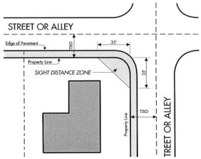
SIGHT DISTANCES
Provided for illustrative purposes only
(Ord. 949 § 12, 2021; Ord. 906 § 8, 2016; Ord. 856 § 2 (Exh. A), 2011; Ord. 745 § 5, 2000; Ord. 710 § 35-16.22, 1996; 1991 code § 35-16.22)
18.50.110 Tree preservation.
The following supplemental regulations are intended to encourage the preservation of trees throughout the community by establishing reasonable provisions for protecting heritage trees and other protected trees and establishing procedures for review and approval of tree removal and replacement. Unrestricted removal of trees without replacement will detrimentally affect the city’s health, safety and welfare. Specifically, removal of or damage to heritage and other protected trees will interfere with the city’s natural and scenic beauty, diminish the tempering effect of these trees on extreme temperatures and adversely impact the city’s unique character and identity.
A. Permit required. No person, firm, corporation, private or public utility or governmental entity shall remove, relocate, excessively trim, damage or demolish a protected tree or heritage tree prior to obtaining a tree removal permit from the zoning administrator or approval from another applicable city decision-making body pursuant to subsection C, I or J of this section. City initiated projects shall also be subject to all of the provisions of this chapter unless specifically exempted by the city council.
1. Protected trees. The term “protected tree” means any of the following:
a. Any native oak tree with a trunk diameter measurement of nine inches or larger.
b. Any indigenous tree with a trunk diameter measurement of nine inches or larger. Indigenous trees include but are not limited to: Alnus Oregona (Red Alder), Acer Macrophyllum (Bigleaf Maple), Aesculus Californica (California Buckeye), Arbutus Menziesii (Madrone), Umbellularia Californica (California Bay or Laurel), Juglans Hindsii (California Black Walnut), Platanus Racemosa (California Sycamore), or Sambucus Mexicana (Elderberry).
Note: The California Native Plant Society list of indigenous/native trees for the Bay Area can also be referenced to determine whether a tree is considered native or indigenous to the region.
c. A nonnative tree (not including Eucalyptus) with a trunk diameter measurement of 18 inches or larger. Nonnative trees include species such as Sequoia Sempervirens (Coastal Redwood), Pinus Canariensis (Canary Island Pine), Pinus Halepensis (Aleppo Pine), Pinus Pinea (Italian Stone Pine), Pinus Radiata (Monterey Pine), Ulmus Americana (American Elm), Ulmus Parvifolia (Chinese Elm), Ulmus Pumila (Siberian Elm), Liquidambar Styraciflua (American Sweet Gum), Cedrus Deodara (Deodar Cedar), Cedrus Atlantica (Atlas Cedar), Fraxinus Uhdei (Shamel Ash), Fraxinus American (White Ash), Fraxinus Augustifolia (Raywood Ash), Cupressus (Cypress species), Morus Alba (Fruit/Fruitless Mulberry), Chinese Pistache, Robinia Pseudoacacia (Black Locust), Pyrus Calleryana (Bradford Pear), Cinnamomum Camphora (Camphor).
d. Any tree shown to be preserved on an approved tentative map, development or site plan or required to be retained as a condition of approval or environmental mitigation measure.
e. Any tree required to be planted as a replacement for an unlawfully removed tree.
f. Any tree designated as a “heritage tree” pursuant to subsection E of this section.
Note: See subsection G of this section for definition of trunk diameter measurement.
2. Arborist report required. Any application for a tree removal permit shall include a letter report prepared by a certified arborist addressing the health/condition of the tree, the rationale for removal, the feasibility of any alternatives to removal, and any recommendations for replacement trees.
3. Criteria for tree removal review. The zoning administrator, or other applicable city decision-making body, shall consider the following factors in determining whether to approve the removal of a tree or trees:
a. Health or physical condition of the tree;
b. Any potential hazard or any risk presented by the tree determined using the ANSI A-300, part 9 Standard for Tree Risk Assessment;
c. Whether the tree is causing a public nuisance and/or a public safety hazard;
d. Potential for the tree to be a detriment to other protected trees due to its location, overcrowding, or its health;
e. Evidence of significant damage to property caused, or likely to be caused, by the tree;
f. Any potential historic or cultural significance of the tree;
g. Whether the tree substantially inhibits sunlight necessary for the operation of active or passive solar heating, cooling or energy generation and trimming or thinning is not a feasible alternative to removal;
h. Whether the tree is obstructing proposed improvements that cannot be reasonably designed to avoid tree removal;
i. Whether the tree is located in close proximity to a structure in a high fire hazard area and removal is necessary to create defensible space per applicable fire safety laws, regulations or Fire District requirements;
j. Whether preservation of the tree(s) would render a site undevelopable and the planning commission or city council has determined that no economically viable use can be made of underlying or adjacent property if the tree is not removed and that every reasonable effort has been made to retain the tree;
k. Feasibility of alternatives to removal of the tree (for example, depending on the circumstances, abandonment in place of a natural gas pipeline that is over 30 years old and relocation of the pipeline may be deemed a feasible alternative);
l. Any other circumstances deemed relevant by the zoning administrator or other city decision-making body based on site conditions, technical analyses, and/or the location of the tree.
4. Third-party peer review arborist. When deemed necessary by the zoning administrator or other applicable city decision-making body, a third-party peer review prepared by a certified arborist, board certified master arborist or registered consulting arborist may be required (at the cost of the applicant) to: (a) review the applicant’s arborist report and/or tree preservation and replacement plan, (b) physically inspect and evaluate the tree(s) proposed for removal, and (c) provide a written analysis to include the peer review arborist’s findings, and recommendations. The peer review arborist’s comments may also include recommendations regarding tree replacement.
5. Replacement trees required.
a. Replacement ratios. Unless otherwise specified by the zoning administrator or other applicable city decision-making body, the replacement ratios for tree removal shall be as follows:
i. A protected native or indigenous tree approved for removal shall be replaced by at least two 15-gallon trees on the project site.
ii. A protected nonnative tree approved for removal shall be replaced by at least one 15 gallon tree on the project site.
iii. In addition to the replacement requirements in subsections A.5.a.i and/or ii of this section, removal of any protected tree (native, indigenous or nonnative), as part of an area-wide program and/or discretionary development plan, that is located within or adjacent to the public right-of-way along Contra Costa Boulevard or within or adjacent to the Iron Horse Trail, may also be subject to additional mitigation requirements to address potential community-wide impacts of removals. Such additional mitigation, if required by the applicable city decision-making body, may include, but not be limited to, proportionate mitigation for adverse effects (individual and cumulative) on biological values, aesthetics, loss of shade, economic vitality, air quality, vehicle speed, community identity, and other similar factors, resulting directly or indirectly from tree removal, that have the potential to cause adverse community-wide social, economic or environmental effects due, in part, to the substantial length of time required for replacement trees to reach the same level of maturity and therefore provide the same functionality and benefits as the trees that are removed.
b. Replacement tree species. The species of the replacement trees shall be approved by the zoning administrator or other applicable city decision-making body.
c. Off-site replacement. Off-site tree replacement may be considered in the event that the project site already has a significant mature tree population, to prevent overcrowding or infringement on existing structures, provided adequate provisions for maintenance of the replacement tree are specified, subject to approval by the planning commission.
d. Replacement infeasible. Where the planning commission or city council has determined that on-site or off-site replacement of trees is not currently feasible, the planning commission or city council may, at its discretion, allow the applicant to make an in lieu payment to the city for provision of off-site trees at the ratio recommended in subsection A.5.a of this section. The in lieu fee shall be based on the estimated value of the replacement tree(s) including any installation and maintenance costs. If the zoning administrator or other applicable city decision-making body determines that on-site or off-site replacement would not be feasible (due to lack of adequate space on site or lack of a suitable and available off-site location), the tree replacement requirement may be reduced or waived, as appropriate. For trees removed within or adjacent to Contra Costa Boulevard and/or within or adjacent to the Iron Horse Trail, additional mitigation for each tree removed may be required as specified in subsection A.5.a.iii of this section.
e. Maintenance. Replacement trees shall be properly maintained by the permittee to ensure their survival. Replacement trees on single-family residential sites shall be maintained for a minimum of two years after planting. Replacement trees on all other sites shall be maintained as noted in any landscape maintenance agreement and/or city approved landscape plan or tree preservation and replacement plan applicable to the site.
B. Exemptions. A tree removal permit is not required prior to removal of a protected tree under any of the following circumstances:
1. Removal is determined necessary by fire department personnel actively engaged in fighting a fire.
2. Immediate removal is required to prevent imminent danger to life or property, such as with a “hazardous tree” as defined in subsection G.4 of this section or if necessary to restore utility service within 48 hours of a storm, and the city manager or his/her designee has been notified of the removal at the earliest opportunity, and it is not feasible to obtain a permit prior to removal (in which case a tree removal permit shall be submitted within five days of removal to ensure that the provisions of this chapter and any other applicable provisions of the municipal code or applicable land use entitlements are satisfied).
3. The tree is held for sale as part of a licensed nursery business.
4. A subdivider or developer need not obtain a separate tree removal permit to remove, relocate or demolish a tree designated as “To Be Removed” on an approved subdivision map (tentative map or parcel map) or development plan provided that the tree removal has been reviewed and approved by the decision-making body for the subdivision map and/or development plan based on the criteria in subsection A.3 of this section and a tree preservation and replacement plan has been approved pursuant to subsection C of this section.
5. The zoning administrator determines that the tree is dead. The zoning administrator may require submittal of a report from a licensed arborist if deemed necessary to verify the condition of the tree. A fee shall not be required for a determination by the zoning administrator that a tree is dead. Dead trees that are removed shall not require replacement unless located on a site with a city-approved landscape plan or landscape maintenance agreement, in which case, the dead tree shall be replaced on a 1:1 basis.
6. Tree trimming that does not constitute “excessive trimming” as defined in this chapter.
7. If a governmental entity or a public or private utility believes it is exempt from this section by federal or state statute, regulation or administrative order, such entity shall provide a copy of such statute, regulation or order to the zoning administrator for approval.
C. Tree preservation and replacement plan. A tree preservation and replacement plan prepared by a state licensed or certified professional shall be submitted by the applicant in conjunction with any discretionary land use entitlement application that includes removal of protected trees (excluding an entitlement involving only one single-family residence where the zoning administrator may administratively require tree protection measures as needed if a proposed development has the potential to adversely impact a protected tree); in addition, a tree preservation and replacement plan may also be required by the zoning administrator or other applicable city decision-making body as a condition of tree removal permit approval. The tree preservation and replacement plan shall be subject to the review and approval of the zoning administrator or other applicable city decision making body and shall include:
1. A map and inventory showing the location, species, health rating, size, and a unique tree number for all trees on the site. The trees to be removed, relocated, or demolished shall be labeled “To Be Removed” or marked with an “X” and the inventory shall indicate by notation why removal of each tree is necessary based on the criteria included in subsection A.3 of this section.
2. A report from a certified arborist, board certified master arborist or registered consulting arborist describing the condition of all existing trees, the anticipated impacts of grading, trenching and construction on the protected trees and recommending specific protective measures to be implemented prior to commencement of grading or construction to minimize potential adverse impacts on protected trees. The report shall designate tree protection zones (TPZ) for each protected tree and/or group of protected trees that are proposed to remain on site and the additional measures such as protective fencing, staking and signage necessary to avoid inadvertent damage to protected trees during grading and construction The TPZ is a restricted activity zone where soil disturbance, storage or parking of vehicles, storage of any other materials or chemicals and/or alteration of drainage is not permitted, unless otherwise approved by the city. All required tree protection measures shall also be included with the grading and/or construction documents for the development.
3. A replanting plan prepared by a licensed landscape architect or other professional approved by the city for replacement of each tree removed as required by the zoning administrator or other applicable city decision-making body. The planting plan shall include replacement trees as required pursuant to subsection A.5 of this section and shall conform with ANSI A-300 Standard Part XXX (Planting).
4. Provisions to ensure ongoing maintenance of any required replacement trees.
D. Performance security. To ensure the safety and well-being of existing protected trees that may be impacted by grading or construction and/or any replacement trees required to be planted pursuant to this chapter, the zoning administrator or other applicable city decision-making body may, at its discretion, require an applicant to post a cash deposit or other performance security acceptable to the city guaranteeing that each such tree will be protected against harm from grading or construction and will be adequately maintained. The performance security must be posted with the zoning administrator prior to issuance of grading permits and shall be governed by the following provisions:
1. The zoning administrator shall establish the amount of the performance security which shall be equal to the estimated value of the protected trees.
2. The performance security shall remain in effect for a period of five years (or two years for single-family residential sites) following the date of final inspection and acceptance of the development project by the city.
3. The performance security shall provide that if the city determines that a protected tree has been removed, permanently damaged, or destroyed due to development activity during the effective period of the performance security, the city is entitled to recover the face amount of the performance security.
4. If, at the expiration of the effective period of the performance security the city determines that the protected trees have not been removed, permanently damaged, or destroyed due to development activity, the performance security shall be refunded or the surety bond terminated.
E. Heritage trees. Notwithstanding any other provisions of this chapter, a tree which is enrolled in the city’s heritage tree program may not be removed, relocated, damaged or demolished, and no permit or tree preservation and replacement plan authorizing such action may be issued, unless the zoning administrator or other applicable city decision-making body determines that there exists a hazard to property or danger of disease or infection to surrounding healthy trees.
1. Eligibility. Any tree in the city with a trunk diameter measurement of 16 inches or more or any tree grouping in the city with at least one tree of this diameter is eligible for enrollment in the heritage tree program, with the consent of the property owner.
2. Enrollment. The zoning administrator shall review and approve applications for enrollment in the heritage tree program unless an eligible tree or tree grouping is unhealthy and cannot be saved. Upon approval of an application, the zoning administrator shall:
a. Record the location and the plant number of each tree or tree grouping.
b. Obtain a color photograph of the tree or tree grouping at the time of its enrollment.
c. Affix a plaque on the tree or tree grouping identifying:
i. The scientific name of the tree(s);
ii. The common name of the tree(s);
iii. The plaque number (i.e., Heritage Tree No. ____); and
iv. The name of the owner.
d. Award a certificate to each property owner enrolling a tree or tree grouping in the program, expressing the appreciation of the city and its citizens.
F. Conditions. The zoning administrator or other applicable city decision-making body may impose reasonable conditions of approval on a tree removal permit, consistent with the purposes of this chapter, to ensure safe and unobtrusive tree removal, replacement, relocation, and demolition; maintenance of replacement trees; and protection of trees not approved to be removed. It shall be a violation of this chapter for any property owner or agent of the owner to fail to comply with any condition of approval or other requirement pursuant to this chapter.
G. Definitions.
1. Damage means any intentional action or gross negligence, which causes injury, death or disfigurement of a tree. Actions include, but are not limited to, cutting, girdling, poisoning, overwatering, soil compaction, unauthorized relocation or transportation of a tree or trenching, excavating, altering the grade or paving within the dripline or tree protection zone (if specified) of a tree.
2. Dead tree means a tree that is dead or that has been damaged beyond repair or is in an advanced state of decline (where an insufficient amount of live tissue, green leaves, limbs or branches exist to sustain life) and has been determined to be such by the zoning administrator.
3. Excessive trimming means removing in excess of one-fourth (25%) or greater, of the functioning leaf, stem or root area within one year. Trimming in excess of 25% is potentially injurious to the tree and is a prohibited act that constitutes removal. Excessive trimming typically results in the tree appearing as a “bonsai,” “lion’s tailed,” or “lolly-popped,” or overly thinned. Excessive trimming also includes removal of the leaf or stem area predominantly on one side, topping, or excessive tree canopy or crown raising. Exceptions may be considered by the zoning administrator subject to review and approval of a tree removal permit pursuant to subsection A of this section when such trimming is determined by the zoning administrator to be the only feasible way to provide necessary clearance from overhead utilities or public improvements or to abate a hazardous condition or public nuisance, or when the trimming is recommended by a certified arborist due to the health and/or structure of the tree. Excessive trimming may also include the cutting of any root two inches or greater in diameter and/or severing in excess of 25% of the roots and/or pruning not in compliance with ANSI A-300, Part I pruning standard for trees, or the International Society of Arboriculture Pruning Best Management Practices (latest available revision of each).
4. Hazardous tree refers to a tree that possesses a structural defect which poses an imminent risk if the tree or part of the tree that would fall on someone or something of value (target). Structural defect means any structural weakness or deformity of a tree or its parts.
5. Tree removal means any of the following: (a) complete tree removal such as cutting to the ground or extraction of the tree; or (b) taking any action foreseeably leading to the death of a tree or permanent damage to its health or structural integrity, including but not limited to excessive trimming, cutting, girdling, poisoning, over-watering, unauthorized relocation or transportation of a tree, or trenching, excavating, altering the grade, or paving within the dripline area of a tree.
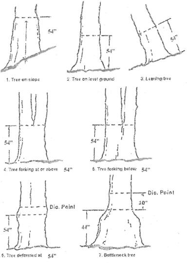
6. Trunk diameter measurement means starting at 54 inches (DBH) above the existing ground surface adjacent to the trunk of the tree, measure the width of the tree from one side of the trunk to the opposite side, or alternatively, measure the circumference of the tree’s trunk (in inches) at that point and divide by Pi (3.14). For trees located on a slope, this measurement is taken from the midpoint between the lowest and highest point of existing grade adjacent to the tree trunk. For trees with more than one trunk, the combined diameter of all trunks measured at 54 inches (DBH) above the ground will determine the diameter of that individual tree (see diagrams below)
.
7. Tree protection zone (TPZ) means a restricted activity zone where soil disturbance, storage or parking of vehicles, storage of any other materials or chemicals and/or alteration of drainage is not permitted, unless otherwise approved by the city. The project arborist or a city arborist shall designate the area of the TPZ with a temporary fenced tree enclosure designed to protect the tree and its roots from disturbance. Within the TPZ, roots that are critical for tree survival are typically found in the upper three-foot soil horizon, and may extend beyond the dripline of the tree. Protecting the roots in the TPZ is necessary to ensure the tree’s survival.
H. Penalties. In addition to all other remedies set forth in the municipal code or otherwise provided by law, the following remedies shall be available to the city for violation of this chapter:
1. For unlawful removal or damage of a native oak tree or heritage tree, a civil penalty may be imposed at the discretion of the city in an amount not to exceed $1,000 per tree unlawfully removed or damaged, or the replacement value of each such tree. Such amount shall be payable to the city. Failure to pay this penalty may result in imposition of a lien or special assessment on the property in the amount of the penalty and any additional costs incurred by the city in addressing the violation. Replacement value for the purposes of this section shall be determined utilizing “trunk formula method” as specified in the most recent edition of the Guide for Plant Appraisal, published by the International Society of Arboriculture.
I. Referral to the planning commission or architectural review commission. The zoning administrator may, in his or her discretion, refer any tree removal permit application directly to the planning commission (or architectural review commission if the removal is on a site with a landscape plan previously approved by the architectural review commission).
J. Tree removal permit expiration. An approved tree removal permit shall be valid for a period of one year from the approval date, unless the tree is removed, or the permit is renewed by the zoning administrator or other hearing body that originally approved it.
K. Appeals. Any decision to approve or deny a tree removal may be appealed by the applicant or any interested party pursuant to the procedures specified in PHMC Chapter 18.130. (Ord. 964 § 11, 2023; Ord. 890 §§ 28, 29, 2015; Ord. 880 § 2, 2014)
18.50.120 Underground utilities.
All electrical, telephone, cable television, and similar distribution lines providing direct service to a development site shall be installed underground within the site and within any public right-of-way or public easement directly adjacent to the site subject to review and approval by the final decision-making body (zoning administrator, planning commission, architectural review commission or city council) on the development project. (Ord. 906 § 9, 2016; Ord. 710 § 35-16.28, 1996; 1991 code § 35-16.28)
18.50.130 Water-conserving landscape design and development.
Repealed by Ord. 858. (Ord. 710 § 35-16.30, 1996; 1991 code § 35-16.30)
18.50.140 Marijuana/cannabis.
A. Personal cultivation of marijuana/cannabis. Within the city of Pleasant Hill, the planting, growing, harvesting, drying, curing, grading, or trimming of marijuana/cannabis is prohibited. Notwithstanding the foregoing, it is not a violation of this section for an individual, who resides in a private residence located on the same parcel as the plant(s), to cultivate for his or her personal use no more than six marijuana plants. Cultivation shall be subject to the following limitations:
1. No more than six marijuana plants per residence are allowed to be cultivated either indoors or outdoors, or a combination of both indoors and outdoors, regardless of the number of individuals residing at the residence.
2. The plants shall not be visible from a public right-of-way, other public place, or adjacent parcel(s).
3. For outdoor cultivation:
a. No part of a plant is within five feet of any property line.
b. All plants must be kept within a locked space (e.g., enclosed within a locked gate).
4. For indoor cultivation:
a. All accessory structures shall comply with the locational and other requirements set forth in PHMC § 18.20.050 or 18.25.060 as applicable.
b. Structures and equipment used for indoor cultivation, such as indoor grow lights, shall comply with all applicable building, electrical and fire code regulations as adopted by the city.
c. The plants must be kept in a locked space within a fully enclosed and secure structure.
5. Nothing in this section is intended to preclude any landlord from limiting or prohibiting personal cultivation of marijuana/cannabis by tenants.
6. Nothing in this section is intended to authorize commercial cultivation of marijuana/cannabis.
7. Nothing in this section is intended to authorize any public or private nuisance due to odor or as otherwise specified in PHMC Chapter 7.05.
B. Commercial cannabis uses. All commercial cannabis uses are expressly prohibited in all base zoning districts and overlay zoning districts unless and until one or more such uses is expressly and affirmatively authorized by this code. The foregoing prohibition shall not apply to:
1. Conduct specified in Business and Professions Code sections 26054(c) and (d), 26080(b), or 26090(e).
2. Cannabis delivery originating from a cannabis retailer located outside of the city.
3. The activities of an individual qualified patient or an individual primary caregiver that are exempt from state licensure pursuant to Business and Professions Code section 26033, or a natural person’s personal use activities in accordance with Health and Safety Code sections 11362.1 and 11362.2, applicable state law and this code.
4. Cannabis temporary events. However, cannabis temporary events, as provided under Business and Professions Code section 26200, are prohibited in the city unless specifically authorized by separate resolution or ordinance of the city council. (Ord. 931 § 1, 2019; Ord. 918 § 2, 2017; Ord. 897 § 1, 2016; Ord. 893 § 2, 2015; Ord. 819 § 5, 2007)
18.50.150 Creek setbacks.
A. Regulation. No person may place a structure (as defined in subsection B of this section), perform grading, or place fill material in a creek setback area unless:
1. The property is adjoining a concrete channel owned by a public agency; or
2. The structure, grading or fill was legally existing as of February 24, 2010. Such a structure, grading or fill may be replaced in kind if the property owner obtains a building permit within 18 months (within the same building footprint and without increasing the degree of nonconformity) without the requirement of a use permit under PHMC § 18.65.030.C; or
3. The property qualifies for an exception under subsection C of this section.
B. Definitions. In this section:
Creek means any one of the creeks in the city as shown on the “City of Pleasant Hill Creek System” map, on file in the public works division.
Creek setback area means a setback area measured from the top of the creek bank, as follows. This regulation applies whether or not the creek is on the property.
|
DEPTH OF CREEK |
CREEK SETBACK AREA, FROM TOP OF CREEK BANK |
|---|---|
|
Up to 5 feet |
5 feet |
|
Over 5 – 10 feet |
10 feet |
|
Over 10 – 15 feet |
15 feet |
|
Over 15 feet |
subject to city engineer review |
(The depth of the creek bed is measured at its deepest point to a point level with the top of creek bank.)
Structure means: a structure as defined in PHMC § 18.140.010. Examples of structures include, but are not limited to: a house addition or second unit; garage; swimming pool or hot tub; arbor; shed; deck; retaining wall; and wall of concrete, masonry or stone.
For purposes of this section, structure does not include any of the following:
1. Structures not attached to the ground or needing a foundation (such as a play structure, dog house, bench or table);
2. A fence/wall not over six feet high (the fence/wall shall be constructed with at least 75% of the fence/wall open to allow the passage of light and air);
3. Flatwork (such as a patio or walkway) less than three inches thick and not used to support another structure;
4. Landscaping;
5. Existing structures legally built before the adoption of this section;
6. Structures prohibited by other regulations (see subsection D of this section).
If any uncertainty exists, the zoning administrator shall determine whether or not a structure is regulated. (PHMC § 18.10.040.A)
The top of the creek bank means the highest edge of the creek channel at the location where the structure, grading or fill is proposed, as determined by the director of public works and community development.
TOP OF CREEK BANK
C. Creek setback exceptions.
1. City engineer determination. The city engineer shall approve an exception if all the following conditions exist:
a. The property is not located in either a 100- or 500-year floodplain as shown on the current FEMA flood insurance rate map;
b. The property is not a “repetitive loss property” as defined by FEMA;
c. The depth of the water in the creek during an average winter storm is less than two feet; and
d. The creek channel has sufficient capacity to carry storm water without flooding adjacent properties in the event of a creek bank failure.
The city engineer’s determination is ministerial, based on the facts of each case. It does not require a public hearing and there is no appeal. An applicant who disagrees with the determination may request a zoning administrator decision under subsection C.2 of this section.
2. Zoning administrator exception. The zoning administrator may approve an exception to the requirements of subsection A of this section, on the recommendation of the city engineer, under the following procedure:
a. General procedures – Application; fee; hearing; decision; appeal. An applicant for a creek setback exception shall file an application with the planning division, together with information required by the city engineer under subsection C.2.b of this section and an application fee in an amount established by city council resolution. The zoning administrator shall hold a noticed public hearing within 30 days after receiving a completed application. The zoning administrator shall render a decision in writing within five working days of the close of the hearing. The decision of the zoning administrator may be appealed as provided in PHMC § 18.130.010.
b. Application information. Information provided for an exception request shall include the following items at the discretion of the city engineer:
i. A topographical survey of the lot precisely showing the creek bed, creek bank, top of bank and proposed and existing structures;
ii. A soils report prepared by a licensed civil engineer specializing in soils analysis which describes the soils condition for the proposed structure and analyzes and makes recommendations as to the creek bank stability and erosion hazard;
iii. Certification by the engineer who prepares the soils report that in the professional opinion of the engineer there is no likelihood of a hazard to persons or property resulting from the proposed construction; and
iv. Structural calculations, hydraulic calculations, or other data as deemed necessary by the city engineer.
c. Zoning administrator findings – Conditions.
i. Findings. The zoning administrator may approve an exception to the creek setback requirement if he or she makes all of the following findings:
(A) The proposed structure does not violate any other city, state or federal regulations (see subsection D of this section);
(B) The proposed structure is not likely to be detrimental to creek stability; and
(C) The property is not located within a special flood hazard area as defined in PHMC § 15.15.050, or, if the property is located within a special flood hazard area, the proposed structure complies with the standards of construction set forth in PHMC Chapter 15.15 (Flood Damage Prevention).
ii. Conditions. In approving an exception, the zoning administrator may impose conditions deemed necessary for creek-side erosion protection and on-site drainage, including the requirement that the property owner enter into an agreement holding the city and other public agencies harmless in the event of flood or erosion damage to any property. The agreement shall be in a form acceptable to the city attorney, be recorded, and bind successors in interest.
D. Other regulations. Construction, development or work within a creek setback area may also be subject to other regulations and guidelines which could result in a larger setback, including but not limited to:
1. City regulations.
a. Zoning district side or rear yard setbacks from the property line, for structures and accessory structures (PHMC § 18.20.050 and Schedules 18.20.030 and 18.25.030);
b. Design guidelines adopted by the city council;
c. California building codes under PHMC Title 14;
d. Grading ordinance (PHMC Chapter 15.10);
e. Requirements applicable in a special flood hazard area under PHMC Chapter 15.15 (Flood Damage Prevention);
f. Erosion protection and water quality requirements under PHMC Chapter 15.05 (Stormwater Management and Discharge Control); and
g. Mitigation measures under the California Environmental Quality Act.
2. Other agency requirements.
a. California Department of Fish and Game.
b. San Francisco Bay Regional Water Quality Control Board.
c. U.S. Army Corps of Engineers.
d. Federal Emergency Management Agency (FEMA).
e. U.S. Fish and Wildlife Service. (Ord. 844 § 2, 2010)
18.50.160 Solar energy systems.
A. Purpose. The purpose of this section is to codify the procedures for reviewing applications for solar energy systems in compliance with California state law and the city’s governing documents.
B. Definitions. In this section:
Electronic submittal means the submission of materials via electronic mail.
Small residential rooftop solar energy system, in accordance with California Government Code section 65850.5, means a solar energy system that meets all of the following:
1. Is no larger than 10 kilowatts alternating current nameplate rating or 30 kilowatts thermal;
2. Conforms to all applicable state fire, structural, electrical, and other building codes as adopted or amended by the city, and all state and city health and safety standards;
3. Conforms to all applicable safety and performance standards established by the California Electrical Code, the Institute of Electrical and Electronics Engineers, and accredited testing laboratories such as Underwriters Laboratories and, where applicable, rules of the Public Utilities Commission regarding safety and reliability;
4. Is installed on a single or duplex family dwelling; and
5. The panel or module array does not exceed the maximum legal building height as defined by the city.
Solar energy system has the meaning set forth in paragraphs (1) and (2) of subdivision (a) of section 801.5 of the Civil Code, as such section or subdivision may be amended, renumbered, or redesignated from time to time.
Specific, adverse impact means a significant, quantifiable, direct, and unavoidable impact, based on objective, identified, and written public health or safety standards, policies, or conditions as they existed on the date the application was deemed complete.
C. Solar energy systems, generally.
1. Applicability and purpose. This subsection C applies to the permitting of solar energy systems in the city, except those that qualify as small residential rooftop solar energy systems, which shall be governed by subsection D of this section. The purpose of this subsection C is to codify the review and permitting of solar energy systems in conformance with California Government Code section 65850.5, as it may be amended from time to time.
2. Review process. A building permit is required for the installation of any solar energy system within the city. A use permit may be required in some circumstances, as set forth in subsection C.4 of this section.
3. Application review. The city shall administratively review applications for solar energy systems. Review shall be limited to whether the proposed system meets all health and safety requirements of the city, the state, and the federal government. The city requirements shall be limited to those standards and regulations necessary to ensure that the solar energy system will not have a specific adverse impact upon the public health or safety. However, if the building official makes a finding, based on substantial evidence, that the solar energy system could have a specific, adverse impact upon the public health or safety, the city may require the applicant to apply for a use permit.
4. Use permit.
a. Notwithstanding any other provision of the Pleasant Hill Municipal Code to the contrary, the building official, in consultation with the zoning administrator, is authorized to issue use permits for solar energy systems. A public hearing on the application for the use permit shall be held and notice of the same shall be provided as set forth in PHMC Chapter 18.80.
b. If a use permit is required, the building official, in consultation with the zoning administrator, may deny an application for the use permit only if the building official makes written findings, based upon substantial evidence in the record, that the proposed installation would have a specific, adverse impact upon public health or safety and there is no feasible method to satisfactorily mitigate or avoid, as defined, the adverse impact. Such findings shall include the basis for the rejection of the potential feasible alternative for preventing the adverse impact. Any such decision may be appealed to the planning commission.
c. Any condition imposed on an application shall be designed to mitigate the specific, adverse impact upon health and safety at the lowest possible cost.
d. A feasible method to satisfactorily mitigate or avoid the specific, adverse impact includes, but is not limited to, any cost-effective method, condition, or mitigation imposed by the city on another similarly situated application in a prior successful application for a permit. The city shall use its best efforts to ensure that the selected method, condition, or mitigation does not significantly increase the cost of the system or decrease its efficiency or specified performance in excess of the following:
i. For solar domestic water heating systems or solar swimming pool heating systems: an amount exceeding 10% of the cost of the system, but in no case more than $1,000, or decreasing the efficiency of the solar energy system by an amount exceeding 10%, as originally specified and proposed.
ii. For photovoltaic systems: an amount not to exceed $1,000 over the system cost as originally specified and proposed, or a decrease in system efficiency of an amount exceeding 10% as originally specified and proposed.
D. Small residential rooftop solar systems.
1. Applicability and purpose. This subsection applies to the permitting of all small residential rooftop solar energy systems in the city. The purpose of this subsection is to create an expedited, streamlined solar permitting process that complies with the Solar Rights Act, as amended by AB 2188 (Chapter 521, Statutes 2014), to achieve timely and cost-effective installations of small residential rooftop solar energy systems. This subsection encourages the use of small residential rooftop solar energy systems by removing unreasonable barriers, minimizing costs to property owners and the city, and expanding the ability of property owners to install small rooftop solar energy systems. This subsection allows the city to achieve these goals while protecting the public health and safety.
2. Small residential rooftop solar system requirements. A solar energy system that qualifies as a small residential rooftop solar energy system, as defined in this section, shall be processed in accordance with the terms of this subsection D.
a. A small residential rooftop solar energy system must meet applicable health and safety standards and requirements imposed by the state and the city, local fire department or district.
b. The city shall adopt an administrative, nondiscretionary expedited review process for small residential rooftop solar energy systems, which shall include standard plan(s) and checklist(s). The checklist(s) shall set forth all requirements with which small residential rooftop solar energy systems must comply with to be eligible for expedited review.
c. The small residential rooftop solar system permit process, standard plan(s), and checklist(s) shall substantially conform to recommendations for expedited permitting, including the checklist and standard plans contained in the most current version of the California Solar Permitting Guidebook adopted by the Governor’s Office of Planning and Research.
3. Applicant obligations. Prior to submitting an application, the applicant shall:
a. Verify, to the applicant’s reasonable satisfaction, through the use of standard engineering evaluation techniques that the support structure for the small residential rooftop solar energy system is stable and adequate to transfer all wind, seismic, and dead and live loads associated with the system to the building foundation; and
b. At the applicant’s cost, verify, to the applicant’s reasonable satisfaction, using standard electrical inspection techniques that the existing electrical system including existing line, load, ground and bonding wiring as well as main panel and subpanel sizes are adequately sized, based on the existing electrical system’s current use, to carry all new photovoltaic electrical loads.
4. Electronic processing.
a. All documents required for the submission of an expedited small residential rooftop solar energy system application shall be made available on a publicly accessible city website.
b. Electronic submittal of the required permit application and documents by electronic means shall be made available to all small residential rooftop solar energy system permit applicants. The city’s website must specify the permitted method of electronic document submission.
c. An applicant’s electronic signature shall be accepted on all forms, applications, and other documents in lieu of a wet signature.
5. Application review.
a. An application that city staff determines satisfies the information requirements contained in the city’s checklist(s) for expedited small residential rooftop solar system processing, including complete supporting documents, shall be deemed complete.
b. If an application is deemed incomplete, a written correction notice detailing all deficiencies in the application and any additional information or documentation required to be eligible for expedited permit issuance shall be sent to the applicant for resubmission.
c. After city staff deems an application complete, city staff shall review the application to determine whether the application meets local, state, and federal health and safety requirements.
d. Unless the building official determines a use permit is warranted, upon submission of a complete application that meets the requirements of the approved checklist, standard plans, and provisions of this section, city staff shall issue a building permit or other nondiscretionary permit in accordance with the timeframes adopted by the city council and in no event later than three days after submission.
e. The building official may require an applicant to apply for a use permit if the building official finds, based on substantial evidence, that the applicant’s proposed solar energy system could have a specific, adverse impact upon the public health and safety.
i. If a use permit is deemed necessary, the process set forth in subsection C.4 of this section shall apply.
ii. Any determination that a use permit is required because of a specific, adverse impact upon the public health and safety may be appealed to the planning commission.
f. The city shall not condition approval of an application on the approval of an association, as defined in California Civil Code section 4080.
6. Inspections.
a. Only one inspection shall be required and performed by the building department for small residential rooftop solar energy systems eligible for expedited review, unless the system fails such inspection.
b. The inspection shall be done in a timely manner.
c. If a small residential rooftop solar energy system fails inspection, a subsequent inspection is authorized but need not conform to the requirements of this section. (Ord. 894 § 2, 2015)
18.50.170 Electric vehicle charging stations.
Repealed by Ord. 961. (Ord. 934 § 5, 2019)