


Chapter 17.08
DEFINITIONS
Sections:
17.08.010 Purpose.
The purpose of this section is to promote consistency and precision in the application and interpretation of this title. The meaning and construction of words and phrases defined in this chapter shall apply throughout this title, except where the context and usage of such words or phrases clearly indicates a different meaning or construction intended in that particular case. (Ord. 185 § 2, 1993)
17.08.020 Interpretations.
A. The word “shall” is mandatory and not discretionary. The word “may” is permissive and discretionary.
B. In case of any difference of meaning or implication between the text of any provision and any caption or illustration, the text shall control.
C. References in the masculine and feminine genders are interchangeable.
D. Unless the context clearly indicates to the contrary, words in the present and the future tense are interchangeable, and words in the singular and plural are interchangeable.
E. Unless the context clearly indicates to the contrary, the following conjunctions shall be interpreted as follows:
1. “And” indicates that all connected items or provisions shall apply.
2. “Or” indicates that the connected items or provisions may apply singly or in any combination.
3. “Either...or” indicates that the connected items or provisions shall apply singly but not in combination.
F. The word “used” shall include arranged, designed, constructed, altered, converted, rented, leased, occupied, or intended to be utilized. (Ord. 185 § 2, 1993)
17.08.030 Definitions.
The following are definitions of terms used in this title. Definitions of specific uses and use categories are contained in Chapter 17.12 SBMC (Use Classifications and Regulations).
A
ABUTTING (ADJACENT): Two or more parcels sharing a common boundary, of at least one point.
ABANDONED (ABANDONMENT): To cease or suspend from developing or maintaining a building or use for a stated period of time.
ACCESS: Safe, adequate, and usable ingress or egress to a property or use (see also LATERAL ACCESS and VERTICAL ACCESS).
ACCESSORY BUILDING OR STRUCTURE: A structure which may either be attached to or detached from a principal structure on the same lot, but which is incidental to the principal building, and not designed for human habitation.
ACCESSORY DWELLING UNIT: A residential dwelling unit that provides complete independent living facilities for one or more persons and is located on a lot with a proposed or existing primary residence, which may be a single dwelling unit or a multifamily dwelling. An accessory dwelling unit shall include permanent provisions for living, sleeping, eating, cooking, and sanitation on the same parcel that the primary residence is or will be situated. An accessory dwelling unit also includes an efficiency unit or a manufactured home, as defined in Section 18007 of the Health and Safety Code.
ACCESSORY DWELLING UNIT, ATTACHED: An accessory dwelling unit that is physically attached to a primary residence and share an interior wall or as an additional story above the primary dwelling unit.
ACCESSORY DWELLING UNIT, DETACHED: An accessory dwelling unit that is not an attached accessory dwelling unit.
ACCESSORY USE: A use which is incidental to, and customarily associated with, a specified principal use, and which meets the applicable conditions set forth in this title.
ACREAGE, GROSS: The total land area within the lot lines of a lot or parcel of land before public streets, easements or other areas to be dedicated or reserved for public use or open space (including undevelopable slopes, bluffs, and sensitive lands) are deducted from such lot or parcel, and does not include adjacent lands already dedicated for such purposes.
ACREAGE, NET: The total land area within the lot lines of a lot or parcel minus land area which will be required for public streets, easements or other areas to be dedicated or reserved for public use or open space (including undevelopable slopes, bluffs, and sensitive lands).
ACTION: The decision made by the review authority on a land use application, including appropriate findings, environmental determination and conditions of approval, where applicable.
ADDITION: Any construction which increases the size of a building or facility in terms of site coverage, height, length, width, or gross floor area.
AGENT: Any person showing written verification that he or she is acting for, and with the knowledge and consent of, a property owner.
ALLEY: A public way, at the rear or side of property, permanently reserved as an ancillary means of vehicular or pedestrian access to abutting property.
ALTERATION: Any construction or physical change in the internal arrangement of rooms or the supporting members of a building or structure, or change in the appearance of any building or structure.
ANIMAL:
1. EXOTIC OR WILD ANIMAL: Any animal not normally domesticated in the U.S. such as, but not limited to, a monkey, fox, raccoon or other similar animal, including predatory or poisonous animals.
2. HOUSEHOLD PET: Any animal customarily permitted and kept in a dwelling and kept only for the company or pleasure provided to the occupants of the dwelling, such as dogs, cats, birds (such as parakeets, canaries, and parrots), tropical fish, small reptiles, rodents (such as hamsters and guinea pigs), pot bellied pigs, or similar domestic animals. Household pets kept within the dwelling, consistent with applicable city, state and federal regulations, are not regulated by this title.
3. LARGE ANIMAL: Any equine or bovine animal, or other domestic animal similar in size, weight, or appearance, including, but not limited to, a horse, pony, mule, donkey, cow or ox.
4. SMALL ANIMAL: Any domestic animal other than a large animal, household pet, fowl, or rodent, including, but not limited to, a goat, lamb or pig or other animals of similar weight, size and appearance.
ANTENNA: A device for transmitting or receiving radio, television, or any other transmitted signal (see also SATELLITE ANTENNA).
APPLICANT: Owner(s) or lessee(s) of property, or their agent(s), or person(s) who have contracted to purchase property contingent upon their ability to acquire the necessary permits under this title, or the agents(s) of such persons.
APPLICATION: The form and information submitted by an applicant. The form and information is to be used to determine whether to approve or deny permits or other entitlement for use.
APPROVAL: The issuance or commitment of issuance by a public agency of each lease, permit, license, certificate, or other entitlement for which an application was accepted as complete (see also ACTION).
AQUACULTURE: A form of agriculture devoted to the controlled growing and harvesting of fish, shellfish, and plants in marine, brackish, and fresh water.
ATTACHED: Any structure that has an interior wall or roof in common with a principal structure; provided such roof in common is architecturally integrated with and is of a compatible material as is used on the principal structure.
AWNING: A roof-like cover that is attached to and projects from the wall of a building for the purpose of shielding from the elements.
B
BASEMENT: Any portion of a building story which has at least 60 percent or more of the story height below the finished grade or pre-existing grade, whichever is lower.

BERM: A mound or embankment of earth (see also FENCE).
BLOCK: An area of land surrounded by public streets, highways, freeways, railroad rights-of-way, flood control channels, canyons, bluffs, open space, unsubdivided acreage, or any combination thereof.
BLOCK FACE: One complete side of a block, usually facing a public street.
BLUFF: An escarpment or steep face of rock, decomposed rock, sediment, or soil resulting from erosion, faulting, folding, filling or excavation of the land mass, with an average slope inclination of 1.25 feet horizontal to one foot vertical or greater. The bluff may be flat, curved, or steplike in section.
BLUFF EDGE: The upper termination of a bluff. When the top edge of a bluff is rounded away from the face of the bluff, the bluff edge shall be defined as that point nearest the bluff beyond which the downward gradient of the land surface increases more or less continuously until it reaches the general gradient of the bluff. In a case where there is a steplike feature at the top of the bluff face, the landward or inward edge of the topmost riser shall be considered the bluff edge. In those cases where irregularities, erosion intrusions, structures or bluff stabilizing devices exist in a subject property so that a reliable determination of the bluff edge cannot be made by visual or topographic evidence, the director shall determine the location of the bluff edge after evaluation of a geologic or soils report and physical inspection of the site.
BLUFF, COASTAL: Any bluff, with a minimum height of 10 feet, which is located between the railroad right-of-way and the Pacific Ocean.
BLUFF, INLAND: Any bluff, with a minimum height of 20 feet, which is not located between the railroad right-of-way and the Pacific Ocean.
BLUFF, NATURAL: Any bluff, the face of which has been created by natural erosion processes.
BUILDABLE LOT: (See LOT).
BUILDING: Any structure having a roof supported by columns or walls.
BUILDING AREA (BUILDABLE AREA): The portion of the lot remaining after deducting all required setbacks and easements from the gross area of the lot.
BUILDING COVERAGE: The percent of lot area which may be covered by all buildings or roofed structures. This includes all accessory buildings or structures, balconies, covered patios, covered entryways and any similar structures that reduce the amount of lot area open to the sky.
BUILDING HEIGHT: The vertical distance between the lower of the pre-existing grade or finished grade to the highest point of the structure, excluding approved architectural features and appurtenances such as, but not limited to, chimneys, vents and antennas. The height measurement shall run with the land in accordance with the applicable grade and shall be made within the planes of the exterior walls. Those portions of basements not visible and below pre-existing and finished grade shall not be included in height measurement (see definition of BASEMENT and PRE-EXISTING GRADE).
BUILDING, HISTORIC: A building listed individually on the National Register of Historic Places, or by a state or county agency charged with the recognition or preservation of historic structures, or by resolution of the city council as having significant local or regional historical or cultural importance and value to the community.
BUILDING, PRINCIPAL: (See PRINCIPAL BUILDING OR STRUCTURE).
BUILDING SITE: The ground area of a building together with all open spaces required by this title (see also ACREAGE, NET).
BUILDING SITE, COMMON: (See COMMON BUILDING SITE).
C
CANYON RIM: The canyon rim shall be determined in the same manner as a bluff edge pursuant to this chapter, whether or not the canyon wall also qualifies as a bluff as defined by this chapter.
CARPORT: A permanent roofed structure not completely enclosed, to be used for vehicle parking.
CATEGORICAL EXCLUSION AREA: A geographic area of the city of Solana Beach, within the coastal zone, where coastal development permits are not required as delineated on Map Drawing 17.08.030-A, on file with the city clerk and the department of community development.
CERTIFICATE OF OCCUPANCY: A permit issued by the department of community development prior to occupancy of a structure to assure that the structure is ready for occupancy with all defects corrected and all construction debris removed and the site graded to final grade. Additionally, all on-site amenities (i.e., paving, landscaping, etc.) shall be in place prior to the issuance of the permit.
CHANGE OF USE: The replacement of an existing use by a new use, or a change in the nature of an existing use, but not including a change of ownership, tenancy, name or management where the previous nature of the use, line of business, or other function is substantially unchanged.
CITY: The city of Solana Beach, California.
COASTAL ZONE: That land and water area of the city of Solana Beach, as described in Public Resources Code Section 30170 and amendments thereto, and as delineated on Map Drawing 17.08.030-A, on file with the city clerk and the department of community development.
COASTAL DEVELOPMENT PERMIT: A discretionary entitlement which is required of development in specified areas of the coastal zone to ensure that such development is consistent with the city of Solana Beach local coastal program.
CONDITIONAL USE PERMIT: A discretionary entitlement which may be granted under the provision of this title and which, when granted, authorizes a specific use to be made of a specific property, subject to compliance with all terms and conditions imposed on the entitlement.
CONDOMINIUM: A development consisting of an undivided interest in common for a portion of a parcel, coupled with a separate interest in space in a residential or commercial building on the parcel.
CONSTRUCTION, COMMENCEMENT OF: The start of substantial site and structural improvement after a building permit has been issued, subject to determination by the director.
COMMON BUILDING SITE: A building site which consists of more than one lot or parcel.
COUNCIL: The city council of Solana Beach, California.
COUNTY: The county of San Diego, California.
COURT: An open, unoccupied space, other than a yard, unobstructed from ground to sky on the same lot with a building or buildings and which is bounded on two or more sides by the walls of a building.
D
DAYLIGHT PLANE: An angled height limit designed to reduce building bulk and to allow additional light and air to pass through to adjacent properties or rights-of-way. Daylight planes are usually specified by a fixed angle beginning at a certain height above a setback or property line.
DAYS: Consecutive calendar days unless otherwise stated.
DENSITY: The number of dwelling units per net acre (see also ACREAGE, NET).
DEPARTMENT: The city of Solana Beach community development department.
DESIGN: Includes the planning and engineering of the following:
1. Street alignments, grades and widths;
2. Drainage and sanitary facilities and utilities, including alignments and grades thereof;
3. Location and size of all required easements and rights-of-way;
4. Lot size and configuration;
5. Traffic access;
6. Grading;
7. Land to be dedicated for park and recreational purposes;
8. Building and such other specific requirements as may be necessary to insure conformity with or to implement the general plan or any adopted specific plan.
DETACHED: Any building or structure that does not have a wall or roof in common with any other building or structure.
DEVELOPMENT: The placement or erection of any solid material or structure; discharge or disposal of any dredged material or any gaseous liquid, solid or thermal waste; grading, removing, dredging, mining or extraction of any soil or materials; change in the density or intensity of use of land, including, but not limited to, subdivision pursuant to the Subdivision Map Act (commencing with Section 66410 of the Government Code), and any other division of land, including lot splits, except where the land division is brought about in connection with the purchase of such land by a public agency for public recreational use; change in the intensity of use of water, or of access thereto; construction, reconstruction, demolition, or alteration of the size of any structure including any facility of any private, public or municipal utility; and the removal of any major vegetation. As used in this title, “structure” includes but is not limited to any building, road, pipe, flume, conduit, siphon, aqueduct, telephone line, and electrical power transmission and distribution line. A “project”, as defined in Government Code Section 65931, is included with this definition.
DEVELOPMENT REVIEW PERMIT: A discretionary entitlement, applicable to specified development, which may be granted under the provision of this title and which, when granted, authorizes a specific use to be made of a specific property, subject to compliance with all terms and conditions imposed on the entitlement. Development review permits are required of certain classes of development projects which due to their scale, proximity to environmentally sensitive areas, or unique design features as provided by a zone of specific plan, require discretionary review to insure consistency with the general plan and the intent of the zone in which the property is located.
DIRECTOR (PLANNING DIRECTOR): The director of the community development department of the city of Solana Beach.
DISCONTINUE (DISCONTINUANCE): The cessation or removal of a use for a specified period of time or permanently.
DORMER: A roofed structure with at least two vertical walls, projecting from a sloping roof and usually housing a window or ventilating louver.
DRIVEWAY: A permanently surfaced area providing direct access for vehicles between a street and a permitted off-street parking or loading area.
DWELLING: A structure or portion thereof designed for residential occupancy, not including hotels or motels.
DWELLING UNIT: One or more rooms including bathrooms(s) and a kitchen, designed as a unit for occupancy by one family for living and sleeping purposes.
E
EASEMENT: A grant of one or more property rights by the property owner for the use by the public, a corporation or another person or entity.
EAVE: The projecting lower edges of a roof overhanging the wall of a building.
EFFICIENCY (DWELLING) UNIT: The smallest dwelling unit allowed by the Uniform Building Code which provides full living quarters, including kitchen and bathroom facilities (see current UBC Chapter 12).
ENCLOSED: A covered space fully surrounded by walls, including windows, doors, and similar opening or architectural features.
EMERGENCY: A sudden, unexpected occurrence demanding immediate action to prevent or mitigate loss of or damage to life, health, property or public services.
ELEVATION:
1. A vertical distance above or below a fixed reference level.
2. A flat scale drawing of the front, rear, or side of a building or structure.
ENGINEER, CITY: The city engineer of the city of Solana Beach.
ENVIRONMENTAL IMPACT REPORT (EIR): A detailed statement setting forth the environmental effects and considerations pertaining to a project as specified in Section 21100 of the California Environmental Quality Act, and may mean either a draft or a final EIR.
ENVIRONMENTALLY SENSITIVE HABITAT: Any area in which plant or animal life or their habitats are either rare or especially valuable because of their special nature or role in an ecosystem, and which could be easily disturbed or degraded by human activities and development (see also SENSITIVE LANDS).
F
FACADE: The exterior wall of a building exposed to public view, or that wall viewed by persons not within the building.
FAMILY: Two or more persons living together as a bona fide single housekeeping unit.
FENCE: An artificially constructed barrier of any material or combination of materials erected to enclose or screen areas of land or to hold back earth above the natural grade. Fences include retaining walls, earthen berms, graded fill slopes and such similar devices when they occur above the natural grade. For the purposes of measuring fence height, a retaining wall/ fence combination shall be considered a single fence whenever the horizontal distance between the retaining wall portion of the fence and the above ground portion of the fence is less than the height of the retaining wall portion alone. The height of a fill slope/fence combination shall be measured in the same manner.
FILL: Any material or substance which is deposited, placed, pushed, dumped, pulled or transported, or moved to a new location and the conditions resulting therefrom. Fill also includes pilings placed for the purpose of erecting structures thereon when located in a submerged area. Examples of fill materials include, but are not limited to, earth, excavated or dredged materials, sand, gravel, rock, riprap, and concrete.
 FIRST PUBLIC ROADWAY: The nearest through public access route (open to vehicular traffic) paralleling the ocean shoreline, which forms a continuous linkage from the northernmost to southernmost limits of the city of Solana Beach shoreline. The first public roadway is designated on Map Drawing 17.08.030-A, on file with the city clerk and the department of community development.
FLOODPLAIN: The relatively flat areas of low lands adjoining, and including, the channel of a river, stream, water course, bay or other body of water which is subject to inundation by the flood water of a 100-year frequency flood as identified on maps provided by the Federal Emergency Management Agency (FEMA).
FLOOR: A horizontal, continuous, supporting or nonsupporting surface. A floor shall be considered to be a continuous plane and shall include interior elevator shafts, interior stairwells, and other similar interior spaces.
FLOOR AREA: (See GROSS FLOOR AREA).
FLOOR AREA RATIO: The numerical value obtained by dividing the total gross floor area of building(s) by the total gross area of the lot. For residential development with ceilings over 15 feet above finished floor height, the floor area of these areas shall be doubled for the purpose of calculating the floor area ratio.
FRONTAGE: The side of a lot abutting a street (the front lot line), except the street side of a corner lot (side street frontage).
G
GARAGE: An enclosed building, or a portion of an enclosed building used for the parking of vehicles.
GENERAL PLAN: The city of Solana Beach general plan as adopted by the city council.
GEOLOGIC (GEOLOGY OR GEOTECHNICAL) REPORT: A complete engineering geology report which includes an evaluation of seismicity, landsliding, and slope stability based on available reference material, visual reconnaissance, detailed geologic mapping and subsurface exploration, etc. The geologic report shall include engineering recommendations for site development sufficient to meet all current city standards for geotechnical reports.
GEOLOGIC RECONNAISSANCE REPORT: A preliminary engineering geology report which includes an overview of the region and specific geology of the site based on review of available reference materials and visual observation of the site. The geologic reconnaissance report will not include engineering recommendations for site development.
GLARE: The effect produced by brightness sufficient to cause annoyance, discomfort, or loss in visual performance and visibility.
GRADE: The degree of rise or descent of a sloping surface (see SLOPE).
GRADE, FINISHED: The final elevation of the ground surface after development.
GRADE, NATURAL: The elevation of the ground surface in its natural state, before man-made alterations (see also PRE-EXISTING GRADE).
GRADING, CALCULATION OF: Grading amounts shall include grading for earthen berm, building pads whether cut or fill or for garages or basements. Recompaction, utility trenching and foundation work not part of the grading for building pads, garages or basements shall not be included in these calculations of grading. Grading done consistent with this definition and completed after July 1, 1985, shall also be included in the calculation of grading for the site or area (See also PRE-EXISTING GRADE).
GROSS ACREAGE: (See ACREAGE, GROSS).
GROSS FLOOR AREA: The area within the surrounding exterior finished wall surface of all buildings, including accessory living units and guest houses, or portion thereof, including lofts, mezzanines, and stairwells, but exclusive of required parking (200 square feet per space), courtyards (with walls on three sides or less and not covered), and basements (must have 60 percent or more of the story height below pre-existing or finished grade, whichever is lower). One one-story detached accessory building used as a storage shed, playhouse, or similar use that does not exceed 120 square feet (residential only) is excluded.
H
HEIGHT: (See BUILDING HEIGHT).
HISTORIC/CULTURAL LANDMARK (SITE): Any building, structure, or site (including significant trees or other plant life located thereon) which has been determined by the city council, pursuant to SBMC 17.60.160, to have significant historical, cultural, architectural or archaeological value.
HOMEOWNERS ASSOCIATION: An organization incorporated under state law among property owners who have common interest in certain property.
HOUSEHOLD PET: (See ANIMAL).
I
ILLEGAL STRUCTURE, USE, OR LOT: A structure, lot, or use which did not conform to applicable laws when constructed or initiated and has not been granted legal nonconforming status by a categorical provision of this title or has not been brought into full conformity by a specific remedy provided in this title.
IMPROVEMENT: Any item which becomes part of, placed upon, or is affixed to real estate.
INTENSIFICATION OF USE: A change in the use of a lot of premises which, based upon the provisions of the underlying zone, requires more off-street parking than did the immediately preceding legal use of such lot or premises.
J
JUNK: Any combustible or noncombustible nonputrescible waste, including but not limited to trash; refuse; paper; glass; cans; bottles; rags; fabrics; bedding; ashes; trimmings from lawns, shrubbery or trees (except when used for mulch or like agricultural purposes); piles of earth (not intended for immediate landscaping use); lumber, metal, plumbing fixtures, bricks, building stones, asphalt, plaster, wire or like materials from the demolition, alteration or construction of buildings or structures not being kept in conjunction with actual lawful construction activities on the site; tires or inner tubes, auto, aircraft or boat parts; plastic or metal parts or scraps; damaged or defective machinery, whether or not repairable; and damaged or defective recreational equipment or household appliances or furnishings, whether or not repairable.
JUNIOR ACCESSORY DWELLING UNIT: Shall have the meaning defined in Section 65852.22 of the California Government Code. An interior unit that is 500 square feet or less and built entirely within a single-family home shall be considered a junior accessory dwelling unit.
K
KITCHEN: Any room, all or any part of which is designed and/or used for the preparation of food, cooking, storage, and refrigeration.
L
LANDSCAPING: An area devoted to or developed and maintained predominately with native or exotic plant materials including lawn, ground cover, trees, shrubs, and other plant materials; and also including accessory decorative outdoor landscape elements such as pools, fountains, paved or decorated surface (excluding driveways, parking, loading, or storage areas), and sculptural elements.
LAND USE: A description of how land (real estate) is occupied or utilized.
LATERAL ACCESS: An area of land providing public access along the shoreline paralleling the water’s edge. Lateral accessways are to be used for public pass and repass, passive recreational use or as otherwise designated in the city of Solana Beach local coastal program land use plan.
LOADING SPACE: An off-street space or berth for the temporary parking of a commercial vehicle while loading or unloading merchandise or materials.
LOCAL COASTAL PROGRAM (LCP): The land use plan (LUP) and implementing ordinances prepared by the city of Solana Beach pursuant to the California Coastal Act of 1976, Public Resources Code Section 30000 et seq.
LOT: Any parcel of real property approved by a record of survey, plat, parcel map, subdivision map, or certificate of compliance, or any parcel legally created or established pursuant to the applicable zoning or subdivision regulations in effect prior to the effective date of application of this title to such parcel. The classification of lots is as follows:
1. CORNER: A lot located at the intersection of two or more streets at an angle of not more than 135 degrees. If the angle is greater than 135 degrees, the lot shall be considered an “interior lot”.
2. FLAG: A lot having access to a street by means of a private driveway, access easement, or parcel of land not meeting the requirements of this title for lot width.
3. INTERIOR: A lot abutting only one street.
4. KEY: A lot with a side line that abuts the rear line of any one or more adjoining lots.
5. THROUGH: A lot other than a corner lot abutting more than one street.
LOT AREA: The total area included within the lines of a lot.
LOT DEPTH: The average distance between the front and rear lot lines or between the front and the intersection of the two side lines, if there is no rear line.
LOT LINE: A line bounding a lot. (See also YARD). The classifications of lot lines are:
1. LOT LINE, FRONT: On an interior lot, the line separating the parcel from the street or private road easement. On a corner lot, the shorter lot line abutting a street or the line designated as the front lot line by a subdivision or parcel map. (If this determination would create or add to the level of nonconformity, or if the lot lines on a corner lot are equal in length, or if the existing lot pattern or building orientation supports building frontages oriented toward the longer lot line, the front lot line shall be determined by the director.) On a through lot, both lot lines abutting the street. (Through lots have two front lot lines and no rear lot lines).
2. LOT LINE, INTERIOR: A lot line not abutting a street. For the purposes of determining required yards, setbacks, and other provisions of this title, a side lot line abutting an alley or private road easement shall be interpreted as an interior lot line (see YARD diagram).
3. LOT LINE, REAR: A lot line, not intersecting a front lot line, which is most distant from and most closely parallel to the front lot line. In the case of an irregularly shaped interior lot or an interior lot bounded by only three lot lines, a line within the lot having a length of 10 feet, parallel to and most distant from the front lot line shall be interpreted as the rear lot line for the purpose of determining required yards, setbacks, and other provisions of this title. For lots fronting on the terminal end of a public or private street, the rear lot line shall be the shorter lot line of the property lines most opposite the front lot line. If this determination would create or add to the level of nonconformity, or if the lot lines most opposite the front lot line are equal in length or if the existing surrounding lot pattern supports the longer lot line, the rear lot line shall be determined by the director.
4. LOT LINE, SIDE: A lot line which is not a front or rear lot line.
5. LOT LINE, STREET: A lot line abutting a street.
LOT WIDTH: The distance between side lot lines, measured at the street property line.
LUMINAIRE: A complete lighting unit including, lamp, reflector, housing, and standard.
M
MAINTENANCE: The general upkeep and repair of buildings, structures, and property. Maintenance does not include additions of building floor area or improvements made to increase the intensity or density of use of the building or premises.
MERGER: The joining of two or more contiguous parcels of land under one ownership into one parcel.
MEDIAN: A paved or planted area separating a street, highway, or access driveway into two or more lanes of opposite direction of travel.
MINOR EXCEPTION: An administrative review and adjustment of selected site development regulations pursuant to SBMC 17.68.030.
MIXED USE DEVELOPMENT: The development of a parcel(s) or structure(s) with two or more different land uses such as, but not limited to, a combination of residential, office, manufacturing, retail, public, or entertainment in a single or physically integrated group of structures.
MULTIFAMILY: Multiple separate housing units for residential (i.e., noncommercial) inhabitants contained within one building or several buildings within one complex. Includes multi-bedroom units, one-bedroom units, efficiency units, studios, and single room occupancy.
N
NOISE: Any undesirable audible sound.
NONCONFORMING STRUCTURE: A physical aspect of a building, structure or improvement that:
1. Does not conform to the development standards described in this title, together with all building standards, without limitation, height, setbacks, parking, type of building, or coverage of lot by structure; and
2. Did comply with the development standards contained in the zoning ordinance in effect at the time the building, structure or improvement was constructed or structurally altered and was lawfully constructed.
NONCONFORMING USE: A use that:
1. Is not within the scope, either expressly or implicitly, of the zoning restrictions set forth in this title which describe the purpose, intent, permissible uses, density, accessory uses and prohibited uses for the zone in which the particular use is located; and
2. Did comply with the zoning restrictions contained in the zoning ordinance in effect at the time the use was created and was lawfully created; and
3. Has not been terminated in accordance with the provisions of Chapter 17.16 SBMC (Nonconforming Uses and Structures).
NONCONFORMITY: A nonconforming use or a nonconforming structure.
O
OPEN SPACE, COMMON: Open space within a project owned, designed, and set aside for use by all occupants of the project or by occupants of a designated portion of the project. Common open space is not dedicated to the public and is owned and maintained by a private organization made up of the open space users. Common open space includes common recreation facilities, open landscaped areas, greenbelts, but excludes pavement or driveway areas, or parkway landscaping within public right-of-way.
OPEN SPACE, PRIVATE: That open space directly adjoining the units or building, which is intended for the private enjoyment of the occupants of the unit or building. Private open space shall in some manner be defined such that its boundaries are evident. Private open space includes private patios or balconies, and front, rear, or side yards on a lot designed for single-family detached or attached housing.
OPEN SPACE, USABLE: Outdoor or unenclosed area on the ground, or on a deck, or terrace, designed and accessible for outdoor living, recreation, pedestrian access, or landscaping, but excluding streets, parking facilities, driveways, utility or service areas, private open space, and any land to be dedicated to the city as open space.
OVERLAY ZONE: (See ZONE, OVERLAY).
P
PAD, BUILDING: That area of a lot graded relatively flat, or to a minimum slope, for the purpose of accommodating a building and related outdoor space.
PARAPET: The extension of the main walls of a building above the roof level.
PARCEL: A parcel of land under one ownership that has been legally subdivided or combined and is shown as a single parcel on the latest equalized assessment roll.
PARK, PUBLIC: (See PUBLIC PARK).
PARKING AREA: Any public or private land area designed and used for parking motor vehicles including parking lots, garages, private driveways and legally designated areas of public streets.
PARKING BAY: The parking module consisting of one or two rows of parking spaces and the aisle from which motor vehicles enter and leave the spaces.
PARKING LOT: An off-street, ground level area, usually surfaced and improved, for the temporary storage of motor vehicles.
PARKING SPACE: A space for the parking of a motor vehicle within a public or private parking area.
PARKWAY: The area of a public street that lies between the curb and the adjacent property line or physical boundary definition such as fences or walls, which is used for landscaping and/or passive recreation purposes.
PERIMETER: The boundaries or borders of a lot, track, or parcel of land.
PERMIT: Written governmental permission issued by an authorized official, empowering the holder thereof to do some act not forbidden by law, but not allowed without such authorization.
PERSON: Any individual, firm, copartnership, joint venture, association, social club, fraternal organization, company, joint stock association, corporation, estate, trust, organization, business, business trust, public agency, school district, the state of California and its political subdivisions or instrumentalities, receiver, syndicate or any group or combination thereof, acting as a unit, including any trustee, receiver or assignee.
PERMITTED USE: Any use allowed in a zone and subject to the restrictions applicable to that zone.
PLANNED UNIT DEVELOPMENT: A development of land that is:
1. Under unified control allowing standards that are specific to a particular project; and
2. Planned and developed as a whole in a single development operation or programmed series of development stages.
The development may include streets, circulation ways, utilities, buildings, open spaces, and other site features and improvements.
PLANNING DIRECTOR: (See DIRECTOR).
PRE-EXISTING GRADE: The natural grade of the site or graded condition of the site as of July 1, 1985.
PRINCIPAL USE: The primary or predominant use of any lot, building or structure.
PRINCIPAL BUILDING OR STRUCTURE: A building or structure in which a principal use is located.
PROJECT: The total development within the boundaries as defined on the development plan.
PUBLIC PARK: A park, playground, swimming pool, beach, pier, reservoir, golf course or athletic field within the city which is under the control, operation or management of the city, the county, or the state.
PUBLIC RIGHT-OF-WAY: A strip of land acquired by reservation, dedication, forced dedication, prescription or condemnation and intended to be occupied by a road, crosswalk, railroad, electric transmission lines, oil or gas pipeline, water line, sanitary storm sewer and other public uses.
PUBLIC VANTAGE POINT: Any publicly accessible location on dedicated or publicly owned property, including but not limited to roadways, parks, and cultural or recreational facilities, which affords a significant view of the ocean, a coastal lagoon, a canyon or hillside area, or any other open space area identified in the general plan.
Q
QUEUE LINE: An area for temporary parking and lining of motor vehicles while awaiting a service or other activity.
R
RECREATIONAL FACILITY: A privately owned or operated use providing facilities for noncommercial outdoor recreation activities, including golf, tennis, swimming, riding, or other outdoor sport or recreation, operated predominantly in the open, except for clubhouses, and incidental enclosed services or facilities.
RECREATION ROOM: A single room in a main building or in an accessory building designed and/or used exclusively for recreational purposes by the occupants or guests of the premises.
RECYCLING: The process by which waste products are reduced to raw materials and transformed into new and often different products, including automobile recycling.
REPAIR: The reconstruction or renewal of any part of an existing building for the purpose of its maintenance.
RETAINING WALL: A fence designed to hold back earth (see also FENCE).
REVIEW AUTHORITY: The person, or decision making body (i.e., planning director or city council) responsible for the review and/or final action on a land use entitlement.
RIGHT-OF-WAY: (See PUBLIC RIGHT-OF-WAY).
RIPARIAN HABITAT: An environment associated with the banks and other adjacent terrestrial environs of freshwater bodies, watercourses, estuaries, and surface-emergent aquifers (springs, seeps, oases) characterized by plant and animal communities which are dependent upon the transport of freshwater in excess of that otherwise available through local precipitation.
S
SATELLITE ANTENNA: A satellite antenna is any instrument or device capable of transmitting or receiving television, microwave, or other electronic communications from a transmitter, or transmitter relay, located in planetary orbit. Satellite antenna include but are not limited to, satellite earth stations, satellite receiving dishes, and dish antenna.
SCALED RESIDENTIAL OVERLAY ZONE: The scaled residential overlay zone (SROZ) includes only low residential (LR); low medium residential (LMR); and medium residential (MR) zones, in six geographical areas, west of the Interstate 5 freeway, as indicated on the city of Solana Beach official zoning map, on file with the city clerk, and available at the department of community development. The SROZ allows the same densities and uses as the underlying residential zones, but requires superseding property development regulations for floor area ratios, and definitions of atriums, bay windows, and basements. The purpose of the SROZ is to preserve and enhance the existing community character and aesthetic quality of the city of Solana Beach, by providing regulations to ensure and protect the character of established residential neighborhoods; and by preserving the traditional scale and seaside orientation of residential areas in the city of Solana Beach (see also SBMC 17.04.020).
SCREENED: Shielded, concealed, and effectively hidden from view by a person standing at ground level on an abutting site, or outside the area or subject to screening, by a fence, wall, hedge, berm, or similar architectural or landscape feature.
SECURITY LIGHTING: The illumination of a building, structure or premises, or portion thereof, such as entrances, driveways, and parking areas to enhance safety and deter potential criminal activity. Security lighting must be appropriate to its intended purpose and shall comply with all exterior lighting regulations for horizontal cutoff and light trespass (SBMC 17.60.060). Security lighting does not include nor shall it cause the outside illumination for aesthetic or dramatic purposes of any buildings, surrounding landscape, adjacent open space areas (public or private) or environmentally sensitive habitat areas.
SENSITIVE LANDS (AREAS): For the purposes of this title, sensitive lands shall include wetlands, wetland buffers, riparian habitat areas, slopes of 25 percent or greater grade, coastal bluffs, natural inland bluffs, beaches, uplands adjoining San Elijo Lagoon and any environmentally sensitive habitat area.
SETBACK: The minimum required distance that a building, structure, parking area or other designated item must be located from a lot line (see also YARD).
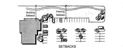
SETBACK LINE: A line within a lot parallel to and measured from a corresponding lot line, forming the boundary of a required yard and governing the placement of structures and uses on the lot (see also YARD).
SHARED PARKING: The sharing under legal agreement of an off-street parking facility or facilities by two or more uses or establishments for the purpose of accommodating their parking needs in a more efficient manner, without conflict or encroachment.
SIGN: Any device, fixture, placard, or structure that uses any color, form, graphic, illumination, symbol, or writing to advertise, to announce the purpose of a person or entity, or to communicate information of any kind to the public. (Definitions for additional terms related to signs and sign regulations are contained in Chapter 17.64 SBMC (Comprehensive Sign Ordinance.))
SINGLE ROOM OCCUPANCY (SRO): See EFFICIENCY (DWELLING) UNIT.
SITE AREA: The net area included within the boundary lines of a site, not including the area within the established right-of-way of a public street, future public street, or railroad, or any other area dedicated or to be dedicated or reserved for a public use or open space including undevelopable slopes, bluffs, and sensitive lands (see also ACREAGE, NET).
SITE PLAN: A plan, prepared to scale, showing accurately and with complete dimensioning, all of the buildings, structures, uses, easements and the exact manner of development proposed for a specific parcel of land.
SLOPE: The degree of deviation of a surface from the horizontal, usually expressed in percent or degrees.

|
% Grade |
100% |
50% |
40% |
33% |
30% |
25% |
|
Degrees |
45° |
26.6° |
21.8° |
18.4° |
16.7° |
14° |
|
Ratio |
1:1 |
2:1 |
2.5:1 |
3:1 |
3.3:1 |
4:1 |
|
|
|
|
|
|
|
|
|
% Grade |
20% |
15% |
12% |
10% |
8% |
6% |
|
Degrees |
11.3° |
8.5° |
6.8° |
5.7° |
4.6° |
3.4° |
|
Ratio |
5:1 |
6.7:1 |
8.3:1 |
10:1 |
12.5:1 |
16.7:1 |
SOILS REPORT: A preliminary report containing a description of site conditions, proposed grading, slopes, planned construction, ground water and soils characteristics to the standards for “soils reports” contained in the Uniform Building Code.
SOLAR ACCESS: A property owner’s right to have sunlight shine on his land or buildings for the specific purposes and to the extent provided under existing state law.
SPECIFIC PLAN: A plan consisting of text, maps, and other documents and exhibits regulating development within a defined area of the city, consistent with the general plan and the provisions of Government Code Section 65450 et seq.
STANDARD INDUSTRIAL CLASSIFICATION (SIC) SYSTEM: The classification of establishments by type of activity which is determined by its principal product or group of products produced or distributed, or services rendered. The purpose of the system is to facilitate the collection, tabulation, presentation and analysis of data relating to the establishments. This system is detailed in the federal Office of Management and Budget’s Standard Industrial Classification Manual, as amended.
STORAGE: A space or place where goods, materials and/or personal property is put for more than 24 hours.
STORY: That portion of a building included between the surface of any floor and the surface of any floor next above it, or if there is no floor above it, then the space between such floor and the ceiling above it.
STREET: Any public thoroughfare which affords a primary means of access to abutting property. A street does not include private road easements or alleys.
STRUCTURAL ALTERATIONS: Any change in the supporting members of a structure such as the bearing walls or partitions, columns, beams or girders.
STRUCTURE: Anything constructed or erected the use of which requires location on the ground or attachment to something having location on the ground.
STRUCTURE, PRINCIPAL: (See PRINCIPAL BUILDING OR STRUCTURE).
STRUCTURE, ACCESSORY: (See ACCESSORY BUILDING OR STRUCTURE).
STRUCTURE, TEMPORARY: A structure without any foundation or footings and which is removed when the designated time period, activity, or use for which the temporary structure was erected has ceased.
SUBDIVISION: The division of a lot, tract or parcel of land into two or more lots, tracts, parcels or other divisions of land for sale, development or lease.
T
TOWNHOUSE: A building subdivided into individual units such that each owner owns the unit structure and the land on which the unit is located, plus a common interest in the land upon which the building is located.
TRANSIENT BASIS: A continuous period of one week or less.
TEMPORARY USE: A use established for a specified period of time, with the intent to discontinue the use at the end of the designated time period.
U
UPLANDS (UPLAND SLOPES): The undeveloped slopes, watershed, and canyon areas which drain into San Elijo Lagoon, including all areas located within the Holmwood Canyon-San Elijo Lagoon Ecological Reserve.
USE: The purpose (type and extent) for which land or a building is arranged, designed, or intended, or for which either land or a structure is occupied or maintained.
USE, ACCESSORY: (See ACCESSORY USE).
USE, CHANGE OF: (See CHANGE OF USE).
USE, CONDITIONAL: A use, listed by the regulations of any particular zone as a conditional use within that zone and allowable therein, solely on a discretionary and conditional basis, subject to a conditional use permit, and to all other regulations established by this title (see also CONDITIONAL USE PERMIT).
USE DETERMINATION: The procedures and findings for classifying a use which is not identified in the Use Regulations Matrix (Table 17.12.020-A).
USE, INTENSIFICATION OF: (See INTENSIFICATION OF USE).
USE, PERMITTED: (See PERMITTED USE).
USE, PRINCIPAL: (See PRINCIPAL USE).
USE REGULATIONS MATRIX (USE MATRIX): A table within this title (Table 17.12.020-A) which lists common use types and indicates how such uses are regulated within any given base zone. Uses may be permitted, permitted with limitations, conditionally permitted by the planning director or city council, or prohibited.
USE, TEMPORARY: (See TEMPORARY USE).
V
VARIANCE: A discretionary entitlement which permits the departure from the strict application of the development standards contained in this title.
VERTICAL ACCESS: An area of land providing a connection between the first public roadway or use area nearest the sea and the publicly owned tidelands or established lateral accessway. A vertical accessway may be used for public pass and repass, passive recreational use or as otherwise designated in the city of Solana Beach local coastal program land use plan.
W
WALL: (See FENCE).
WALL, RETAINING: (See RETAINING WALL).
WETLANDS: Land which is transitional between terrestrial and aquatic systems where the water table is usually at or near the surface or where the land is covered by shallow water. In addition, all wetlands must have one or more of the following characteristics:
1. At least periodically, the land supports predominantly hydrophytes.
2. The substrate is predominantly undrained hydric soil.
3. The substrate is nonsoil and is saturated with water or covered by shallow water at some time during the growing season of each year.
Areas classifiable as wetlands include, but are not limited to, lagoons, marshes, estuaries, mudflats, vernal pools, streams and rivers and associated riparian habitat areas.
WETLAND BUFFER: Lands which provide a buffer area of an appropriate size to protect the environmental and functional habitat values of the wetland.
Y
YARD: An open space on a parcel of land, other than a court, unobstructed and unoccupied from the ground upward, except for projections or encroachment permitted by this title (see also LOT LINE).
1. FRONT: An area extending across the full width of the lot between the front lot line or the existing or future street right-of-way or private road easement and a structural setback line parallel thereto. On through lots, two front yards are required. For lots fronting on the terminal end of a public or private street without a cul-de-sac, the front yard shall be determined by a 25-foot radius arc measured from the point of the intersection of the center of the street and the property line.
2. INTERIOR SIDE: An area extending from the required front yard or, where there is no required front yard, from the front lot line to the required rear yard or, where there is no required rear yard, to the rear lot line and from the interior side lot line to a structural setback line parallel thereto.
3. REAR: An area extending across the full width of the lot between the rear lot line and a setback line parallel thereto, exclusive of any area defined as a street side yard.
4. STREET SIDE: An area extending from the required front yard or, where there is no required front yard, from the front lot line to the rear lot line, and from the side street lot line, or the existing or future side street right-of-way (whichever is greater) to a structural setback line parallel thereto. A street side yard is not required where a side lot line abuts a private road easement or alley.

Z
ZONE, BASE (UNDERLYING): A specifically delineated area in the city within which regulations and requirements uniformly govern the use, placement, spacing and size of land and building. Not more than one base zone designation shall apply to the same portion of a lot.
ZONE, OVERLAY: A specifically delineated area established by this title, within which regulations may be applied to a lot or portion thereof only in combination with a base zone.
ZONING ORDINANCE: Title 17 of the Solana Beach Municipal Code.
ZERO LOT LINE: The location of a structure on a lot in such a manner that one or more of the building’s sides rests directly on a lot line. 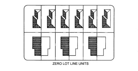
(Ord. 525 § 2, 2023; Ord. 455 § 1, 2014; Ord. 445 § 6, 2014; Ord. 357 § 2, 2007; Ord. 319 § 1, 2003; Ord. 300 § 1, 2003; Ord. 215 § 3, 1996; Ord. 191 § 1, 1994; Ord. 185 § 2, 1993)