


LAND USE ELEMENT
Adopted by Res. 2014-141, passed November 19, 2014.
I. Introduction
This Land Use Element describes existing land use characteristics and development patterns in Solana Beach and establishes a plan for future development and redevelopment. It identifies issues that affect land use planning and articulates the goals and policies that are designed to ensure a well-balanced and compatible mix of land uses that are consistent with the community’s character and image.
A. Content
The Land Use Element is required by state law. As specified in Government Code Section 65302(a), the Land Use Element:
Designates the proposed general distribution and general location and extent of the uses of the land for housing, business, industry, open space (including agriculture, natural resources, recreation, and enjoyment of scenic beauty), education, public buildings and grounds, solid and liquid waste disposal facilities, and other categories of public and private uses of land. The location and designation of land for public and private uses shall consider natural resources including rivers, creeks, streams, flood corridors, riparian habitats, and land that may accommodate floodwater for purposes of groundwater recharge and storm water management.
The Land Use Element shall include a statement of the standards of population density and building intensity recommended for the various districts and other territory covered by the plan.
The Land Use Element shall also identify and annually review those areas covered by the plan that are subject to flooding identified by flood plain mapping prepared by the Federal Emergency Management Agency (FEMA) or the Department of Water Resources.
The Land Use Element shall also do both of the following:
(1) Designate in a land use category that provides for timber production those parcels of real property zoned for timberland production pursuant to the California Timberland Productivity Act of 1982.
(2) Consider the impact of new growth on military readiness activities carried out on military bases, installations, and operating and training areas, when proposing zoning ordinances or designating land uses covered by the General Plan for land, or other territory adjacent to military facilities, or underlying designated military aviation routes and airspace.
B. Purpose
This Land Use Element is intended to establish a long range plan for development that reflects the opportunities and constraints affecting land use in Solana Beach. It is meant to maintain a balanced land use pattern with a mix of uses that preserve the city’s residential and recreational character while enhancing economic vitality and protecting cultural and environmental features. It is also aimed at ensuring the ongoing availability and maintenance of adequate public facilities and services in support of existing and future development.
C. Key Issues
Solana Beach is essentially built-out with very little vacant land remaining (approximately 22 acres or one percent of the total land area). Therefore, future development will primarily involve the redevelopment or reuse of currently developed parcels and infill development on the city’s few remaining vacant parcels. In general, such development is expected to occur in the area west of Interstate 5 (I-5). This is primarily due to the age and mix of this area’s existing development.
In addition to a lack of vacant land, a variety of physical and environmental constraints will also affect future development such as small lot sizes and irregular parcel configurations, steep slopes, and sensitive coastal bluffs.
As new development occurs, one of the highest priorities of the City of Solana Beach is to maintain the small town coastal community charm by respecting the beachside setting, considering scenic views, minimizing conflicts among adjacent land uses, and ensuring that new development is compatible with existing community character.
Another key issue is environmental protection. Solana Beach is known for its environmental stewardship and has taken many steps towards becoming a more sustainable community. Furthering the use of green building techniques, reducing greenhouse gas emissions, improving water quality, promoting alternative modes of transportation, reducing energy and water consumption, and increasing energy efficiency and the availability of renewable resources are very important considerations for future development.
Promoting public health is also extremely important to Solana Beach. To encourage physical activity, the City is dedicated to improving and expanding its network of bicycle and pedestrian pathways, enhancing the walkability and livability of its neighborhoods, maintaining a high sense of safety and security, increasing recreational opportunities, and raising awareness about the importance of healthy behaviors and physical fitness to overall well-being. To support respiratory health, the City will be looking for ways to lower harmful greenhouse gas emissions and improve air quality. Additionally, the City will be seeking opportunities to foster healthy eating habits and facilitate access to nutritious foods by promoting organic community or private farms or gardens and other edible landscapes.
The Land Use Element also supports implementation of the Circulation and Housing Elements. State law requires that the Circulation Element plan for a balanced, multimodal transportation network that meets the needs of all users. However physical modifications to existing streets to better accommodate pedestrians, bicyclists, and transit riders is not enough to encourage these alternative forms of travel. The land use pattern and the character of land development also impacts travel behavior. Mixed-use, compact development that reduces the distance between trip origins and destinations makes other modes of travel more viable. In addition, a visually attractive environment that is designed for the comfort of pedestrians and bicyclists also encourages non-motorized travel. These issues are addressed in this Land Use Element.
Furthermore, State law requires that the Land Use Element contain enough land designated for residential development at appropriate densities to accommodate the City’s projected housing needs for all income levels. Solana Beach contains adequate sites designated for mixed-use and higher density residential to accommodate its share of the regional housing need. These sites are generally located where mixed-use and compact infill development is encouraged such as along the planned multi-modal boulevards and adjacent to existing commercial areas. Accommodating additional housing in these locations further supports the goals and objectives of the Land Use and Circulation Elements.
II. Historical Context
Solana Beach’s initial development dates back to the early 20th century when George Jones acquired 220 acres of land known as Lockwood Mesa in 1908. The acreage was used by Jones for more than a decade to cultivate grain and lima beans. Other early activities which influenced the formation of Solana Beach were the Santa Fe Railroad operations and the development of Highway 101, prior to World War I.
In 1922, Colonel Ed Fletcher of the Santa Fe Land and Improvement Company acquired the Jones property. On March 5, 1923, Fletcher filed the original subdivision map of Solana Beach. Fletcher then proceeded to cut an opening through the bluffs so that the beach could be viewed from the townsite. Following several months of hydraulic operations, an opening to the beach was created at what is now known as the Plaza, just west of the Highway 101/Lomas Santa Fe Drive intersection.
The availability of an adequate water supply from Lake Hodges enabled Fletcher and his associates to begin developing the community. Prior to the onset of the Great Depression in 1929, about one-half of the town site had been sold. Following the Depression and World War II, Solana Beach and several other nearby communities continued to grow with residential and commercial development.
In the late 1960s, in response to requests from major community organizations in the San Dieguito area, the County of San Diego initiated preparation of the San Dieguito General Plan. The General Plan was followed by the more detailed San Dieguito Community Plan (adopted in 1974) which was intended to regulate and control growth in the area’s unincorporated communities, including Solana Beach. Urban development in Solana Beach continued in the area west of I-5, generally on a parcel-by-parcel basis. Conversely, most of the area east of I-5 developed pursuant to the Lomas Santa Fe Master Plan. By the mid-1980s, Solana Beach had become highly developed with only a few remaining acres of undeveloped property.
On April 30, 1985, a committee of Solana Beach residents named “Citizens Intending to Incorporate” (CITI) filed a formal application for incorporation as the City of Solana Beach. Following approval by the County’s Local Agency Formation Commission and the affirmative vote by the citizens, the City of Solana Beach was officially incorporated on July 1, 1986.
III. Existing Conditions
A. Existing Land Uses
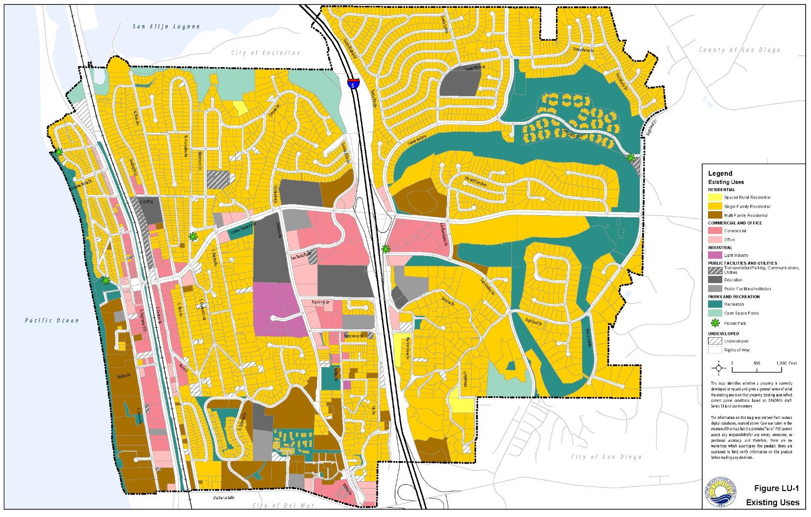
Solana Beach is comprised of approximately 2,200 acres of land area or 3.4 square miles. Existing land uses in Solana Beach are predominantly residential, accounting for approximately 56 percent of city’s land area. There are approximately 6,540 housing units in Solana Beach as reported by the 2010 U.S. Census. Other predominant land uses include recreation/open space, which accounts for approximately 11 percent of the total area, and commercial uses, which account for approximately four percent of the total land area. A significant amount of land area (approximately 20 percent) is occupied by right-of-way. This area includes all roadways, including I-5, and right-of-way associated with the rail line. Table LU-1 summarizes Solana Beach’s existing land use composition and Figure LU-1 is a map identifying the existing development pattern.
|
Existing Land Use |
Acres |
Percent |
|---|---|---|
|
Vacant |
22.39 |
1.0 % |
|
Residential |
1175.06 |
53.7 % |
|
Commercial |
101.09 |
4.6 % |
|
Light Industry |
23.09 |
1.0 % |
|
Office / Professional |
43.48 |
2.0 % |
|
Recreation / Open Space |
284.02 |
13.0 % |
|
Public / Institutional |
92.43 |
4.2 % |
|
Right-of-Way |
449.02 |
20.5 % |
|
Total |
2190.58 |
100.0 % |
Source: SANDAG Draft Series 2013 land use inventory
Residential uses are located throughout the city with a large concentration of pre-World War II housing developments occurring on the western side of the city while the more modern developments took form after World War II in the eastern portion of the city.
Solana Beach’s predominant commercial land uses are located along Highway 101 and Lomas Santa Fe Drive, which are the primary areas of Solana Beach’s commercial business activity. In addition, Cedros Avenue offers a mix of commercial, office/professional, and light industrial land uses and also represents an important focus of Solana Beach’s business activity. Concentrated commercial uses also exist on Stevens and Valley Avenues. Within Solana Beach’s commercial areas, residential uses may be allowed as a secondary use in conjunction with permitted commercial uses.
Other business-related land uses such as office/professional and light industrial uses represent a minor proportion of Solana Beach’s existing land use and each amount to approximately two percent of Solana Beach’s existing land area.
During the 1940’s, an increase in industrial and manufacturing uses occurred along Cedros Avenue. By the 1990’s, however, the South Cedros area began a rapid transformation into a pedestrian-friendly, retail environment and upscale design district with artisans, decorators and antique dealers. The South Cedros Improvement District installed new street lights, curbs, gutter, sidewalks and undergrounded overhead utilities. Currently, existing light industrial land uses in Solana Beach are minimal and tend to be limited to the areas of Stevens Avenue West, and a few parcels on North and South Cedros Avenue. Types of uses in light industrial areas consist of mini-warehouse/storage, commissioned furniture design, art studios, and iron works.
Recreation lands within the community include Fletcher Cove, Tide Beach, and North Seascape Surf beach parks, La Colonia Park, the Lomas Santa Fe Country Club, and the Lomas Santa Fe Executive Golf Course. Most of the open space in Solana Beach is a result of natural conservation efforts, especially in the Holmwood Canyon area and in proximity to the Pacific Ocean, San Elijo and San Dieguito Lagoons.
Public and quasi-public uses include schools, public facilities, churches, medical facilities, and utilities, among others. Examples of specific uses include Skyline Elementary School, Earl Warren Middle School, Solana Beach Fire Department, City Hall, and the Amtrak/Coaster Train Station, which relocated from Del Mar in 1995. The train tracks were lowered in 1999.
Vacant lands in Solana Beach account for approximately one (1) percent of the total land area in Solana Beach and are dispersed throughout the city. Of the vacant parcels, the majority (17 acres) is planned for future residential uses, while only four (4) acres are planned for commercial uses.
B. Local Coastal Program
In 1976, the California Legislature enacted the Coastal Act, which created a mandate for coastal cities and counties to manage the conservation and development of coastal zone areas through a comprehensive planning and regulatory program called the Local Coastal Program (LCP). The LCP is intended to ensure that the local government’s land use plans, zoning ordinances, zoning maps, and implementation actions meet the requirements of, and implement the provisions and policies of, the Coastal Act at the local level.
Solana Beach is located entirely within the state’s coastal zone. The City’s LCP consists of a Land Use Plan (LUP) and a future Local Implementation Plan (LIP), which together will meet the Coastal Act requirements. The LCP/LUP represents a collaborative planning effort initiated by the City and developed over the course of many years with the participation of various interests, including environmental groups and property owners. On February 27, 2013, the City Council adopted the City’s first California Coastal Commission (CCC) approved LCP/LUP. At that meeting, the City Council also directed City staff to begin preparing a Land Use Plan Amendment (LUPA) to modify some of the key provisions in the LUP relating primarily to bluff top development and shoreline protection. Staff developed the LUPA in conjunction with CCC staff and interested stakeholders. The LUPA was certified by the CCC on January 9, 2014 and approved by the City Council on June 11, 2014. The next step is for the LIP to be approved by both the Coastal Commission and the City Council.
Once both the LCP/LUP and LIP are ratified, permit authority to review and approve development in Solana Beach will be transferred to the City, which will apply the requirements of the LCP/LUP and LIP in reviewing new development proposals. The Coastal Commission will still act on appeals from local government coastal permit decisions and review and approve any amendments to the previously certified LCP/LUP and LIP.
Two notable provisions of the approved LCP/LUP involve: 1) the creation of a Visitor Serving Commercial Overlay (VSCO) as a land use category; and 2) requirements that new building improvements be setback a safe distance from the bluff edge. The purpose of the VSCO is to provide land to meet the demand for goods and services required primarily by the tourist population, as well as local residents who use the beach area. To reduce the need for bluff retention devices, foundation footings for all new development on bluff property will be landward of an established Geologic Setback Line (GSL).
This General Plan maintains consistency with the LCP/LUP.
C. Redevelopment Plan Transition
On July 13, 2004, the Agency and the City Council adopted Ordinance No. 326, which approved and adopted the Solana Beach Redevelopment Project as the official Redevelopment Plan. Two redevelopment project areas were created: 1) the Highway 101 commercial corridor, generally located north of Dahlia Drive and 2) the Eden Gardens residential neighborhood. Combined, these two areas covered approximately 226 acres.
Due to recent budget challenges for the State of California, the legislature has passed bills to recover redevelopment funds from local governments and to dismantle the various redevelopment agencies. While some benefits of redevelopment have already been realized in Solana Beach, significant capital improvement projects identified in the Redevelopment Plan remain to be completed including the La Colonia Park improvements and the Solana Beach Train Station.
Because premature dissolution of the Solana Beach Redevelopment Agency (RDA) may result in these projects and others being delayed, or worse, failing to come to fruition, the City Council adopted Ordinance 432 on September 14, 2011, whereby the City elected to comply with and participate in the Alternative Voluntary Redevelopment Program contained in Part 1.9 of Division 24 of the California Health and Safety Code.
Ordinance 432 was the first step in the process for the City to “opt in” under AB 1X 27 so that the RDA could continue to function and implement various necessary and beneficial public projects, while the California Redevelopment Agency (CRA) / League of California Cities (LCC) petition progressed in the court system.
The California Supreme Court issued a ruling in December 2011, effectively shutting down redevelopment agencies. Each RDA is now operated by a “successor agency” board, which has been established to manage property tax revenues, debt retirement, and asset disposal. Each of these successor agencies is governed by a seven-member oversight board and is evaluated on how the remaining, encumbered funds are used.
Despite the recent actions by the court, it is anticipated that redevelopment of existing uses will continue to be vital to the community’s long term health and well-being. However, the process of revitalization will need to rely more on private investment activities due to the loss of public redevelopment funding.
D. Specific and Master Plans
1. Highway 101 Corridor Specific Plan
The Highway 101 Corridor Specific Plan is a plan for physical development and redevelopment of this important roadway area that significantly defines Solana Beach. Highway 101 has grown over the decades to serve as a vital commercial corridor for the region. Developed with extensive community participation, the adopted plan envisions revitalization of the Plaza, Fletcher Cove Park, the Highway 101 corridor, and North and South Cedros, as the heart or downtown of Solana Beach.
The Highway 101 Corridor Specific Plan identifies the types, intensity, location, standards, criteria and implementation measures for future development and conservation of the 163-acre project area. It was originally adopted by Ordinance No. 303, effective June 19, 2003, and later amended by Ordinance No. 346, effective July 28, 2006.
With most of the land area built out, the future development and redevelopment of this vital commercial corridor is essential to the long term economic stability of the community. The Specific Plan is intended to integrate open space, the beach, community facilities, residential neighborhoods, retail businesses, and transit access. The vision includes a more attractive, pedestrian-oriented commercial core, improved landscaping and development quality along the Highway 101 corridor, and creation of a distinct image that maintains an eclectic, low-key, small town vibe.
2. North Rios Specific Plan
In 1997, the North Rios Specific Plan was adopted to rezone approximately 10 acres of agricultural land to low-density residential. The intent of the North Rios Specific Plan was to create a compatible and complimentary land use adjacent to the existing residential neighborhood, and to produce aesthetically pleasing design elements for sustainable neighborhood planning.
The subject land, located at the northeast corner of Rios Avenue and Patty Hill Drive, is situated approximately 300 feet south of the San Elijo Lagoon. Specifically, the property is located between Rios Avenue to the west and the slope embankment of the Barbara Avenue subdivision to the east. The residential development proposed to create a “livable” neighborhood through the implementation of sensitive street and lot design. Varied setbacks respond to the individual conditions of each parcel and the overall goals of the project.
To date, all of the subject property has been developed for residential use.
3. Tangaroa Estates Specific Plan
The Tangaroa Estates Specific Plan provides for the residential development of nine lots, located at the northern terminus and east of Rios Avenue on the northern edge of the San Elijo Lagoon. The Specific Plan satisfies the terms of Resolution No. 96-94, dated September 3, 1996, which amended the General Plan Land Use Map and approved rezoning the subject property from a combination of agricultural and open space/recreation to a combination of low density residential and open space/recreation.
To date, all of the subject property has been developed for residential use.
4. Eden Gardens Master Streetscape Plan
Eden Gardens is one of the oldest residential neighborhoods in Solana Beach. The Eden Gardens Master Streetscape Plan seeks to improve the unique public streetscape in the area with design elements such as lighting, sidewalks, special pavings, curbs, on-street parking configuration, and signage within public rights-of-way. Some of the key streetscape concepts include Mexican-American heritage as the design unifier and special paving at key entry points. The plan was adopted in 1995 and is being implemented in phases.
As funding becomes available, projects are prioritized as part of the City’s Capital Improvements Program.
5. Art Master Plan
Public art fosters a sense of arrival and distinction to Solana Beach’s scenic coastal community, so many of the city’s main entrances or “gateway” locations are well suited for public art such as:
• The northern and southern ends of Highway 101, including access to the Coastal Rail Trail;
• The corner of Via de la Villa and Valley Avenue; and
• Intersections with Lomas Santa Fe at Highway 101 (Plaza St.), I-5, and Highland Dr.
To enhance the identity of Solana Beach as an artistic community, a public art program has been developed to acquire and exhibit quality works of art. The public art program will result in a mixture of enriching opportunities, cultural events, and a visual art collection that reflects the local environment, cultural values, and artistic vitality of the community.
With the assistance of the Public Arts Committee (PAC), the City adopted a Master Art Plan (MAP), which establishes guidelines and formalizes the process to acquire and fund public art. It also establishes mechanisms to ensure new development projects incorporate public art into the cityscape and it establishes uniform administrative guidelines and procedures to follow for all new art/artistic proposals presented to the City Council for review.
E. Timberland
The planning area does not contain any land suitable for timber production and does not contain any parcels of real property zoned for timberland production pursuant to the California Timberland Productivity Act of 1982 (Chapter 6.7 (commencing with Government Code Section 51100) of Part 1 of Division 1 of Title 5).
F. Military Facilities
The impact of new growth on military readiness activities has been considered as part of this General Plan update. There are no military facilities within the planning area and no land use changes are proposed. Therefore, this General Plan will not have an impact on surrounding military facilities. The following facilities were considered as part of this update:
• Naval Base San Diego (approximately 26 miles south of Solana Beach)
• Naval Base Coronado and Naval Air Station North Island (approximately 29 miles south of Solana Beach)
• Naval Base Point Loma (approximately 25 miles south of Solana Beach)
• Marine Corps Recruit Depot San Diego (approximately 20 miles south of Solana Beach)
• Marine Corps Air Station Miramar (approximately 16 miles southeast of Solana Beach)
• Marine Corps Base Camp Pendleton (approximately 31 miles north of Solana Beach)
• March Air Force Reserve Base (approximately 79 miles northeast of Solana Beach)
G. Schools
Solana Beach is served by the Solana Beach School District and the San Dieguito Union High School District. The Solana Beach school district has a total enrollment of approximately 3,000 students in kindergarten through sixth grade (K-6)1. The District also serves the communities of Carmel Valley, Fairbanks Ranch, and Rancho Santa Fe. The District has six elementary schools and a seventh Child Development Center with programs for toddlers, preschoolers, and before and after school support and services. The elementary schools are: Solana Vista (K-3); Skyline (4-6 and the K-6 Global Education Program); Solana Santa Fe (K-6); Carmel Creek (K-4); Solana Highlands (K-4); and Solana Pacific (5-6).
Two schools within the San Dieguito Union High School District serve Solana Beach: Earl Warren Middle School and Torrey Pines High School. Earl Warren Middle School is located at 155 Stevens Avenue in Solana Beach and Torrey Pines High School is located at 3710 Del Mar Heights Road in San Diego.
In addition to these public schools, there are also a variety of private schools located within various land use designations throughout Solana Beach.
IV. Future Development Considerations
A. Infill Development and Reuse of Currently Developed Parcels
As previously noted, there are very few remaining vacant parcels in Solana Beach, so the majority of future development will likely involve the redevelopment or reuse of currently developed parcels and infill development on the few remaining vacant parcels. The areas where future reuse of developed parcels and infill development are most likely to occur include areas along Highway 101 and Lomas Santa Fe Drive, where the majority of the city’s commercially-designated land is located. Residential development is permitted within the commercial land use designations and more mixed-use projects are expected as these areas evolve over time. This increased mix of land uses, particularly near the transit station, is expected to promote public transit use, walking, and biking. To complement this development, additional streetscape enhancements have been recently completed along the Highway 101 corridor.
Maintaining community character and minimizing potential conflicts between adjacent land uses is particularly important for future infill development and redevelopment. The generally quiet nature of residential neighborhoods should be preserved and the bulk and scale of new development should be sensitive to the context of its surroundings. Measures that may minimize the potential for conflicts among adjacent land uses include, but are not limited to:
• Locating commercial land uses along arterial roadways to buffer traffic noise from residential areas;
• Providing an adequate circulation system and sufficient parking to minimize spillover into residential areas;
• Respecting private views;
• Minimizing apparent size, bulk, and scale through appropriate roof style and pitch, varied setbacks, and stepbacks; and
• Emulating the form and characteristics of existing surrounding development.
B. Public Health and the Environment
A better understanding of the connections between human health and a healthy environment has become increasingly widespread in recent years and has helped to garner more support for sustainable development. There are a number of planning decisions related to transportation systems, density and intensity of uses, land use practices, and street design which influence travel behaviors, stress levels, eating habits, and air and water quality – all factors that affect human health. The following are specific examples of just some of the potential hazards associated with modern development that degrade the quality of the natural environment and also impact public health.
• Urban air pollution from vehicles, power plants, and industrial facilities can trigger respiratory health problems such as asthma2.
• Increased greenhouse gases contribute to global climate change which can have significant effects on human health. Rising sea levels can displace populations in low-lying coastal areas and taint drinking water supplies as saltwater intrudes into the groundwater aquifer; rising temperatures can lead to droughts, heat-related deaths, decreases in crop yields, and increased risks for wildfires; and heavy rains can lead to catastrophic flooding3.
• Stratospheric ozone depletion from manmade chemicals can cause increased amounts of ultra-violet (UV) radiation to reach the Earth leading to more cases of skin cancer, cataracts, and impaired immune systems4. Even though the use of many ozone depleting substances such as chlorofluorocarbons (CFCs) have been reduced or eliminated, their use in the past is still affecting the ozone layer because such substances degrade very slowly.
• Storm water runoff that picks up trash, animal waste, cigarette butts, motor oil, pesticides, and other pollutants flows untreated into local creeks, rivers, and the ocean, thereby contaminating sea life and habitats and leading to increased risk of viral infections, earaches, sinus problems, fever, flu, skin rashes, and viral diseases for humans swimming in these water bodies5.
• A development pattern that relies heavily on automobiles further contributes to urban air pollution and reduces opportunities for physical activity, which in turn can increase risks for developing heart disease, diabetes, high blood pressure, colon and breast cancer, obesity, and depression and anxiety6.
Sustainable development refers to a mode of human development in which resources are used in such a manner as to meet current human needs while also preserving the environment to ensure the ability of future generations to meet their own needs. Solana Beach is motivated to ensure that future development takes steps to meet public and environmental health objectives through measures such as encouraging new development to be designed in a manner that promotes use of other forms of transportation besides the private automobile; providing enhanced infrastructure and recreational opportunities to promote physical activity; implementing green building practices; maximizing water and energy efficiency and waste reduction; improving water quality; and encouraging the use of renewable energy sources. An emphasis has been placed on public health in this Land Use Element and throughout the General Plan.
C. Physical Constraints
The potential for new development in the city may be constrained by small and/or irregular parcel configurations. For example, the extent of new commercial development along Highway 101 or Cedros Avenue is contingent upon the availability of lots with adequate depth and width to accommodate proposed developments that meet municipal code requirements.
A variety of environmental constraints affects potential land development in Solana Beach. For example, slope stability problems along the entire coastal bluff area pose a significant constraint to bluff top development. Similarly, steep slopes limit the extent of potential development in hillside areas. The potential for new development along the northwestern edge of the city is limited by the presence of the San Elijo Lagoon and concerns involving the sensitivity of the lagoon’s biological resources.
D. Public Service Constraints
The potential for land use intensification and new development in Solana Beach is subject to constraints imposed by the ability of public service agencies and utilities to provide adequate levels of service to such development. For example, new development can place additional demands upon the San Diego County Sheriff’s Department, the Solana Beach Fire Department, the Solana Beach School District, and the San Dieguito High School District. Further, such developments could necessitate the extension of, or improvements to, water lines, electrical lines, natural gas lines, and possibly sewer lines from existing facilities.
It should be noted that public service agencies and utilities typically incorporate city and regional growth projections into their planning for potential service requirements. In addition, infill development generally results in a more efficient use of land and existing infrastructure. Maximizing the use of existing public facilities can also lower the per capita costs of providing and maintaining services. However, it is important to ensure that growth in the city does not accelerate to a degree that precludes the provision of adequate service levels due to fiscal limitations.
E. Regional Planning Issues
SANDAG has developed a Regional Comprehensive Plan (RCP) referred to as San Diego Forward – The Regional Plan to serve as the long-term planning framework for the San Diego region. The RCP balances regional population, housing, and employment growth with habitat preservation, agriculture, open space, and infrastructure needs. It directs SANDAG to use regional transportation funding as an incentive for local agencies and service providers to make land use decisions and infrastructure investments that direct growth towards areas where compact, mixed-use, and pedestrian-oriented development exists now, is currently planned, or has the potential to occur in the future. The intent is to encourage sustainable development that improves connections between land uses and multimodal transportation options. The RCP is closely tied to the Regional Transportation Plan (RTP) and the Sustainable Communities Strategy (SCS), which demonstrates how regional greenhouse gas emission reduction targets will be achieved through sustainable development patterns, infrastructure investments, and transportation measures that offer more travel options.
This Land Use Element is intended to complement and maintain consistency with these regional plans. The majority of redevelopment, infill, and new growth is expected to occur within the “downtown” or “town center” area of Solana Beach, generally located along Highway 101 and North and South Cedros. These areas are intended to accommodate compact, mixed-use, and walkable areas that are connected to the regional transportation system. Regional coordination will be a key to effectively guiding transportation funding and investment to these areas.
This land use pattern will also help the City to address global climate change issues by making bicycling, walking, and public transit more viable options for everyday travel. Decreasing reliance on automobiles can significantly reduce greenhouse gas emissions.
F. Relationship to the Circulation and Housing Elements
All elements of a General Plan, whether mandatory or optional, must be consistent with one another. In addition, there must be internal consistency within each element meaning that each element’s data, analyses, goals, policies, and implementation programs must be consistent with and complement one another. All elements of a General Plan also have equal weight and equal status – no one element is more important than another.
Although there are relationships among all of the General Plan elements, there are three elements that are intrinsically linked: Land Use, Circulation, and Housing. Government Code Section 65302(b) requires that the Circulation Element is correlated with the Land Use Element. This is because land use patterns have a significant impact on the effectiveness of a multimodal transportation network. Trip distance is a determinant of whether people walk, ride a bike, drive, or take public transit to various destinations. Therefore, the land use plan and transportation network should be complementary. The close proximity of land uses can help facilitate effective multi-modal transportation services and provide the ridership necessary to support high quality public transit. In Solana Beach, compact infill and mixed-use development is most likely to occur west of I-5, mainly within the vicinity of existing commercial areas along Highway 101, Stevens Avenue, and Lomas Santa Fe Drive. The circulation network has been designed to concentrate the multimodal street typologies in these areas with enhanced bicycle and pedestrian connections to surrounding neighborhoods. The Land Use Element also includes goals and policies to ensure that new development enhances community character and leads to the creation of a high quality visual environment that is attractive to non-motorized travel.
Housing element law requires local governments to adequately plan to meet their existing and projected housing needs including their share of the regional housing need. A regional housing needs allocation (RHNA) process quantifies the number of additional housing units that are projected to be needed for each income level during an eight year planning cycle. To accommodate the RHNA numbers, the Housing Element must demonstrate site development capacity equivalent to, or exceeding, the projected housing need to facilitate development of a variety of types of housing for all income groups. If a jurisdiction lacks adequate housing sites, then the Land Use Element must be amended to designate additional land for residential uses at densities appropriate to encourage and facilitate a variety of housing types to accommodate all income levels. High density residential and commercial zones are the most suitable for development of housing affordable to very low- and low-income households because they accommodate up to 20 dwelling units per acre creating economies of scale and potentially lowering construction costs. In addition, these sites are generally located in close proximity to public transit and commercial land uses thereby decreasing reliance on the automobile and lowering household costs associated with driving. This Land Use Element contains adequate residential and mixed-use land use designations to accommodate the RHNA numbers for Solana Beach. Residential development is permitted within the commercial areas that are anticipated to accommodate infill and redevelopment opportunities. Higher density residential designations are also located within close proximity to these commercial hubs.
G. Consistency between the General Plan and Zoning
Pursuant to Government Code Section 65860, consistency must be maintained between the General Plan and zoning designations. For example, areas designated exclusively for residential use in the General Plan cannot be zoned and developed with commercial uses or vice versa. Zoning is one of the key tools used to implement the General Plan.
V. Goals and Policies
The following goals and policies are responsive to the key issues and land use considerations affecting Solana Beach and are intended to guide future development within the city.
Goal LU-1.0: A well-balanced and functional mix of residential, commercial, mixed-use, industrial, agricultural, open space, recreational, and institutional land uses.
Residential Land Uses
Policy LU-1.1 Encourage the development and protection of healthy residential neighborhoods by ensuring sensitive transitions between those neighborhoods and adjoining areas and preventing deterioration through rehabilitation and maintenance efforts.
Policy LU-1.2 The City’s land use plan shall include residential land uses comprising a range of housing types, locations, and densities.
Policy LU-1.3 In order to protect the rental housing stock, protect purchasers of dwelling units, assure consistency with the General Plan density requirements, assure adequate parking, and assure adequate public facilities, conversion of existing apartments to condominiums or other similar forms of subdivision shall be regulated pursuant to City zoning and subdivision ordinances. The regulations shall ensure that conversion of apartments to condominiums or other similar types of subdivisions will meet current standards for the construction of new condominiums or other similar types of multi-family dwellings within the city.
Policy LU-1.4 Pursue opportunities to improve and protect existing residential neighborhoods by enhancing the pedestrian and bicycle experience, implementing traffic calming measures where appropriate, and providing convenient access to schools, parks, beaches, and other amenities and services.
Commercial Land Uses
Policy LU-1.5 Encourage the development of commercial land uses which strengthen the city’s economic base and offer a range of commercial enterprises to meet the needs of residents and visitors by:
• Maintaining an adequate amount of acreage designated for a range of commercial land uses.
• Maintaining an adequate amount of acreage to be used for visitor-serving commercial land uses along Highway 101.
• Continuing to develop special commercial land uses along the north side of Genevieve pursuant to specific design controls established by the City to allow for limited light industrial development.
• Pursuing available methods, including new state redevelopment law, in order to provide infrastructure, land, and other incentives needed to provide opportunities for the redevelopment of commercial areas.
• Continuing to implement the specific development standards established for Highway 101 and Cedros Avenue.
• Considering the creation of development standards and/or design guidelines for other areas of the community as appropriate, in collaboration with residents, businesses, and property owners.
Mixed-Use Land Uses
Policy LU-1.6 Encourage the establishment of mixed-uses that provide for housing and jobs near transit routes, shopping areas, and recreational uses to promote public transit use, walking, and biking.
Policy LU-1.7 Encourage and facilitate neighborhood serving restaurants, including outdoor dining/sidewalk cafes, in mixed-use areas and along the Highway 101 corridor.
Policy LU-1.8 Within mixed-use areas, encourage an overall high quality streetscape design, where feasible and appropriate, that includes bike lanes; on-street parking; minimal curb cuts; enhanced crosswalks; appropriate sidewalk widths; parkways; street trees, planters, and wells; street lighting; street furniture; wayfinding; kiosks; enhanced paving; public art; and other features that contribute to the character of Solana Beach.
Industrial Land Uses
Policy LU-1.9 Allow for light industrial land uses to diversify Solana Beach’s economic base and provide additional local employment opportunities.
Agricultural Land Uses
Policy LU-1.10 Encourage the establishment of organic private and community gardens and other edible landscapes that provide local and sustainable fruits and vegetables.
Open Space and Recreational Land Uses
Policy LU-1.11 Provide an adequate amount of open space and recreational land uses to meet the needs of the entire community by:
• Providing for open space along the city’s beaches, within parks, lagoons, scenic overlooks, and other appropriate locations.
• Providing adequate access to public open space and recreational areas.
• Seeking additional opportunities to increase the amount of public open space and recreational land uses within the city through means such as, but not limited to, land acquisition, conversion of public rights of way to parks, and the establishment of public recreational opportunities within buildings, where feasible.
Institutional Land Uses
Policy LU-1.12 Provide for the development of an adequate amount of institutional land uses to meet the social, economic, cultural, spiritual, and educational needs of the community by:
• Including areas designated for institutional land uses on the City’s land use plan.
• Permitting the development of publicly owned facilities and schools, churches and synagogues, hospitals and medical centers, and retirement care facilities and convalescent homes within areas designated as institutional.
Goal LU-2.0: Regional coordination and collaboration in the development of land use plans and projects.
Policy LU-2.1 Consider local development plans within the context of regional land use and transportation patterns and utilize SANDAG’s Regional Transportation Plan, Regional Comprehensive Plan, and Sustainable Communities Strategy to inform land use and transportation planning and policy development.
Policy LU-2.2 Encourage appropriate smart growth, transit, residential, or mixed-use projects.
Policy LU-2.3 Work with and understand the planning efforts of the adjacent cities of Encinitas, Del Mar, and San Diego, special districts, service providers, and San Diego County, as well as regional, state, and federal agencies when implementing the General Plan.
Policy LU-2.4 Participate in the development of federal, state, and regional plans and projects that have the potential to impact Solana Beach, such as the expansion of Interstate 5, the Los Angeles/San Diego Railway Corridor, and the future of the Del Mar Fairgrounds.
Goal LU-3.0: To be a leader in efforts to reduce greenhouse gas emissions.
Policy LU-3.1 Concentrate commercial, mixed-use, and medium to high density residential development along transit corridors and near activity centers that can be served efficiently by public transit and alternative transportation modes.
Policy LU-3.2 Enable residents to reduce their commutes by allowing and encouraging the creation of live/work units for artists, craftspeople, and other professions, promoting home occupations and telecommuting, and supporting other means of achieving a jobs/housing balance.
Policy LU-3.3 Identify and prioritize infrastructure improvements needed to support increased use of alternatives to private vehicle travel, including transit, bicycle, and pedestrian modes.
Policy LU-3.4 To reduce energy consumption and emissions from new buildings and significant remodels, encourage building placement, design, and construction techniques that minimize energy consumption; require the installation of EnergyStar® appliances and/or other high efficiency facilities; and promote other green building practices, including obtaining LEED (Leadership in Energy and Environmental Design) certification, where feasible.
Policy LU-3.5 Reduce the urban heat island effect through sustainable design and building practices, cool roofs, green roofs, light colored pavement, shade trees, shading, and other means.
Policy LU-3.6 Promote the use of solar panels, solar hot water heaters, and other green energy sources in conjunction with new development and retrofits to existing structures.
Policy LU-3.7 Consistent with the California Public Utilities Commission’s California Long Term Energy Efficiency Strategic Plan, strive to achieve zero net energy use for new residential development by 2020 and zero net energy use for new commercial development by 2030.
Policy LU-3.8 Conserve natural lands for carbon sequestration and promote urban forestry, emphasizing the use of native, drought tolerant trees and vegetation.
Policy LU-3.9 Continue to evaluate and manage the City’s facilities (including its vehicle fleet) and operations to reduce emissions.
Policy LU-3.10 Encourage community involvement and promote public education information programs and public-private partnerships to address and adapt to climate change to the extent possible.
Policy LU-3.11 Maintain and implement a Climate Action Plan.
Goal LU-4.0: To be prepared for the potential effects of climate change including increased flooding, reduced water supply, higher fire danger, and greater energy demands.
Policy LU-4.1 Work to establish adaptive management strategies that respond to the changing environment associated with global warming.
Policy LU-4.2 Inform the public about potential changes in the climate and strategies for adaptation.
Policy LU-4.3 Work with appropriate responsible and regional agencies to track environmental indicators of climate change, such as: sea level; minimum and maximum temperature; precipitation; timing and volume of river flow; river temperatures; sea surface temperatures; and diversity and abundance of fish stocks and sea birds.
Goal LU-5.0: To ensure that long-term protection of the environment is given the highest priority in the consideration of development proposals and in the implementation of this General Plan.
Restrictions on Land with Sensitive Environmental, Geographic, or Geologic Features
Policy LU-5.1 To ensure that development does not create adverse environmental, geographic, or geologic impacts, the City Council shall maintain ordinances for the preservation of hillsides, floodplains, sensitive biological areas, canyons, wetlands, coastal lands, scenic public views and, where feasible, private views. The Council shall also continue to regulate development of property within special hazard areas, including floodplains, coastal bluffs, and steep hillside areas.
Policy LU-5.2 For purposes of determining residential land use intensity, the following general rules shall apply:
a. Public rights-of-way for streets, railroad rights-of-way, and utility easements for high voltage electrical transmission lines shall be considered to be undevelopable except for appropriate street, railroad or utility uses.
b. For the purposes of determining General Plan compatibility of subdivisions and multi-dwelling unit projects, the total number of residential dwellings that may be permitted on property shall be established by applying the following slope density guidelines: slopes with a grade of less than 25 percent shall be considered fully developable; slopes with a grade of 25 percent to 40 percent shall be considered developable at the full residential density, but 1/2 the floor area ratio (FAR) otherwise designated for the site; slopes with a grade of 40 percent or more shall be considered undevelopable; and for those areas along the coastal bluff and lands adjoining the San Elijo Lagoon, slopes with a grade of greater than 25 percent shall be considered undevelopable.
c. The density established by this General Plan shall not be construed to establish a “guaranteed” or “vested” right to a specific number of dwelling units, but as a guideline for determining appropriate zoning and for making land use permit decisions consistent with environmental planning, public facilities, geologic and other sound land use planning concerns. When determining the appropriate zoning applicable to a site, the City Council shall consider the topographic, environmental, geographic, and public facilities constraints applicable to the site. Whenever density is expressed in terms of a density range, zoning, subdivision, and other land use decisions establishing density for a site at a number which is greater than the lowest number established by the density range shall be justified by consideration of such matters as: superior project design; public facility availability; availability of public transportation; proximity to public recreation; provision of public facilities or community amenities by the developer of the site; views; traffic; surrounding land uses; whether the increased density will assist the City in meeting its regional housing obligations and local housing goals; whether the increased density will adversely affect the neighborhood; or whether the increased density will assist the City in meeting other General Plan goals and objectives. Whenever application of the density established for a site results in a fractional density, the decision making authority may deem a fractional density of .7 of a dwelling unit or greater to be one dwelling.
d. The density regulations of this General Plan shall not be construed to prohibit the development or redevelopment of one single family residential dwelling on any residentially zoned lot legally existing on the date of the adoption of the General Plan, provided the structure complies with the minimum requirements established for the development of single-family residential structures in the zoning ordinance other than density or lot size requirements.
e. Density bonuses shall be permitted consistent with California’s density bonus law (Government Code Section 65915-65918).
f. An accessory living unit shall be permitted regardless of maximum density or minimum lot size on any parcel containing a single-family detached primary unit within a residential land use designation.
Policy LU-5.3 Except where necessary to prevent the denial of all reasonable economic use of property as determined by the City Council after hearing, grading on natural slopes with an average inclination in excess of 25 percent shall be restricted. This policy shall be used to maintain as much of the natural terrain as possible, while allowing reasonable use of property. The City Council may allow minor grading for the construction of one single family dwelling unit and driveway for up to 20 percent of a legal lot consisting entirely of slopes of 25 percent or more if other non-grading approaches to development are not feasible.
Policy LU-5.4 Ensure that potential impacts to biological resources are carefully evaluated prior to approval of development projects.
Water Quality and Conservation
Policy LU-5.5 Encourage the use of “green” storm water management and low impact development practices, including green roofs, landscape-based treatment measures, bioswales, tree wells, pervious materials for hardscape, and other techniques that allow for filtering, infiltration, storage and reuse or evaporation of storm water runoff onsite.
Policy LU-5.6 Promote watershed awareness programs that address the discharge of preventable contaminants into the sanitary sewer and drainage systems and support water quality educational programs for City staff and the community.
Policy LU-5.7 Work with the Santa Fe Irrigation District regarding the demands of new development within the capacity of the water system.
Policy LU-5.8 Promote the use of cisterns, rain barrels, and other means of capturing rainwater to reuse onsite to augment the District’s water supplies.
Policy LU-5.9 Encourage the use of native, drought tolerant plants and discourage the use of vegetative turf, unless recreation needs or other area functions specifically require turf.
Policy LU-5.10 Utilize reclaimed/recycled water for irrigation and other purposes, as feasible.
Policy LU-5.11 Encourage and promote methods to conserve water.
Reduction, Reuse, and Recycling of Waste
Policy LU-5.12 Require all projects with a valuation of $100,000 or more to salvage, recycle, or reuse at least 75% of demolition debris.
Policy LU-5.13 Promote the use of recycled materials as part of new construction or renovations, including the reuse of existing building shells/elements.
Policy LU-5.14 Encourage recycling by all sectors of the community including residents, businesses, and schools and inform residents and businesses about composting and “green purchasing”.
Policy LU-5.15 Encourage residents to donate surplus furniture, old electronics, clothing and other household items rather than disposing of such materials in landfills.
Environmental Protection and Improved Economic Health
Policy LU-5.16 Pursue the development of “clean” or “green” sector industries that benefit the environment and economy.
Policy LU-5.17 Recognize exemplary individuals and businesses that have implemented sustainable practices.
Policy LU-5.18 Demonstrate the cost savings of energy efficiency, water conservation, and other sustainable practices.
Goal LU-6.0: Development that is consistent with the overall community character and contributes positively towards the city’s image.
Policy LU-6.1 Distribute and develop land uses in a manner that minimizes the potential for conflicts involving adjacent land uses.
Policy LU-6.2 Encourage the development of multiple-family residential land uses near non-residential uses (eg., commercial centers, light industrial uses, etc.) and provide for adequate buffers where single-family residential areas are already located adjacent to such non-residential uses.
Policy LU-6.3 Maintain ordinances to encourage the preservation of private views.
Policy LU-6.4 Preserve, protect, and enhance established residential neighborhoods by providing sensitive transitions and buffers between those neighborhoods and adjacent commercial or mixed-use areas to safeguard residences from the negative effects of increased traffic, noise, lighting, parking overflow, and other potential impacts.
Policy LU-6.5 Require new development and additions to existing structures to respect and respond to those existing physical characteristics, buildings, streetscapes, open spaces, and urban form that contribute to the overall character and livability of the neighborhood or commercial district in which it is proposed.
Policy LU-6.6 Promote infill development, redevelopment, rehabilitation, and reuse efforts that protect and contribute positively to existing neighborhoods and surrounding areas.
Policy LU-6.7 Promote appropriate transitions in building height and bulk which are sensitive to the visual and physical character of adjacent neighborhoods.
Policy LU-6.8 Require that commercial and mixed-use development provide adequate access and parking to minimize the potential intrusion of commercial traffic into residential neighborhoods.
Policy LU-6.9 Analyze the potential to re-designate areas along Stevens Avenue to mixed-use to promote redevelopment opportunities that contribute positively to the city’s unique character.
Policy LU-6.10 Support the undergrounding of utilities to improve the visual quality of the community.
GOAL LU-7.0: Effective plans, codes, resolutions, ordinances, and zoning to implement this General Plan.
Policy LU-7.1 Ensure that the Capital Improvement Program is consistent with the General Plan.
Policy LU-7.2 Ensure that the zoning ordinance, design guidelines, subdivision ordinance, and grading and improvement requirements are consistent with the General Plan.
Policy LU-7.3 Implement the Local Coastal Program Land Use Plan and Local Implementation Plan.
Policy LU-7.4 Update specific and master plans as appropriate to reflect current trends and maintain consistency with the General Plan and other policy and implementation documents.
Policy LU-7.5 Protect, maintain, and where feasible, enhance and restore coastal resources consistent with the Local Coastal Program.
VI. Land Use Plan
The Solana Beach land use plan has been formulated in response to the key issues and future development considerations discussed in Sections 1.C and IV (e.g., infill and redevelopment considerations, land use compatibility/community character, physical constraints, etc.) and in response to the community’s overall goals and policies concerning land use. The land use plan is very similar to existing development patterns. Realistic build-out projections are consistent with SANDAG population estimates and anticipate that an intensification of uses will occur as a result of infill and redevelopment or reuse of currently developed parcels. It is also anticipated that commercial/residential mixed-use development will occur within commercial zones consistent with existing regulations.
Table LU-2 provides a statistical summary of the land uses provided for in this land use element as well as theoretical and realistic build-out projections. Maximum theoretical build-out assumes that every parcel is built to full capacity whereas realistic build-out recognizes that there are constraints to developing parcels to their maximum allowable densities and intensities. Such constraints include parking and access requirements, setbacks, height limitations, open space provisions, topography, current market conditions, etc.
The predominant land uses in the city will continue to be residential uses (56 percent of total area), open space and recreation areas (10 percent), and commercial/office uses (8 percent). This does not represent a departure from relative proportions of existing land uses.
|
Land Use Category |
Maximum Density and/or FAR1 |
Acres |
% of Total City Acreage |
Theoretical Build-out |
Realistic Build-out |
|---|---|---|---|---|---|
|
Estate Residential |
0-2 du/ac |
288.8 |
13.1% |
577 du |
432 du |
|
Low Density Residential |
3 du/ac |
234.6 |
10.7% |
796 du |
676 du |
|
Low-Medium Density Residential |
4 du/ac |
327.8 |
14.9% |
1,311 du |
1,179 du |
|
Medium-Density Residential |
5-7 du/ac |
164.3 |
7.5% |
1,150 du |
1,035 du |
|
Medium-High Density Residential |
8-12 du/ac |
84.3 |
3.8% |
1,011 du |
909 du |
|
High Density Residential |
13-20 du/ac |
130.3 |
5.9% |
2,606 du |
2,345 du |
|
General Commercial |
20 du/ac 1.0 FAR2 1.2 FAR3 |
108.2 |
4.9% |
2,164 du 5,655,830 sf |
324 du 1,879,649 sf |
|
Light Commercial |
12 du/ac 1.0 FAR 1.2 FAR3 |
2.2 |
0.1% |
26 du 114,998 sf |
2 du 43,987 sf |
|
Special Commercial |
20 du/ac 1.0 FAR 1.2 FAR3 |
34.2 |
1.6% |
684 du 1,787,702 sf |
68 du 835,751 sf |
|
Office/Professional |
1.0 |
28.2 |
1.3% |
1,228,392 sf |
859,874 sf |
|
Light Industrial |
2.0 |
23.0 |
1.0% |
2,003,760 sf |
701,316 sf |
|
Public/Institutional |
2.0 |
74.4 |
3.4% |
6,481,728 sf |
2,916,777 sf |
|
Open Space/Recreation |
0.7 |
208.3 |
9.5% |
6,351,483 sf |
69,979 sf |
|
Open Space/Preservation |
n/a |
21.2 |
1.0% |
646,430 sf |
n/a |
|
Right-of-way |
n/a |
470.5 |
21.4% |
n/a |
n/a |
|
Total |
n/a |
2,200.3 |
100% |
10,325 du 24,270,324 sf |
6,970 du 7,307,333 sf |
1. Maximum density is expressed in terms of the number of dwelling units per acre (du/ac). FAR stands for floor area ratio and refers to the ratio of a building’s total allowable floor area based on the size of the parcel of land upon which it is built. For example, if a parcel is 1,400 square feet (sf) and the FAR is 2.0, then the maximum building size is 2,800 sf.
2. Commercial-only development within the Highway 101 Corridor Specific Plan is limited to a FAR of 1.0. General commercial development outside of the Specific Plan has an FAR of 1.2.
3. Within the Highway 101 Corridor Specific Plan, a FAR of 1.2 is permitted for mixed commercial/residential development. Commercial-only development is limited to a FAR of 1.0.
Realistic build-out for the horizon year of 2035 for residential uses is based on existing unit counts and an assumption that lower density designations are more constrained than higher density designations and will experience less additional growth and change. The estate density residential designation is assumed to build-out at 75 percent of the maximum theoretical capacity. The low density designation is assumed to build-out at 85 percent of the maximum theoretical capacity. All other residential zones are assumed to build-out at 90 percent of the maximum theoretical capacity. In the commercial zones, mixed commercial/residential development is expected to constitute approximately 10 percent of the total development capacity.
The total number of housing units estimated at build-out was compared to SANDAG projections to ensure consistency. SANDAG estimates that Solana Beach will contain a total of 6,869 housing units in 2030 and 6,997 housing units in 20407. The General Plan 2035 build-out of 6,970 housing units fits within this range.
Realistic build-out for square footages was estimated based on an analysis of the existing square footages on currently developed parcels compared to the maximum square footage allowed under the City’s development regulations. In the light and special commercial designations, it was assumed that approximately 10 percent of total development area would be developed with mixed commercial/residential development at the higher FAR of 1.2. In general, general commercial parcels tend to build out at 35 percent of maximum capacity, special commercial parcels tend to build out at approximately 55 percent of maximum capacity, office professional parcels tend to build out at approximately 70 percent maximum capacity, and industrial parcels tend to build out at approximately 35 percent maximum capacity. No data is available for light commercial or public institutional properties, so it was estimated that they would build out at around 45 percent of maximum capacity. Recreational facilities on land designated as open space/recreation are estimated to build out at approximately one percent of maximum capacity.
The individual General Plan land use categories are described below and identified on Figure LU-2, General Plan Land Use Map. Consistent with the State Density Bonus Law (California Government Code Section 65915 et seq.), a developer, upon request, shall be granted a density bonus, incentive(s), concession(s), and/or modification of development standard(s) if the developer proposes to build a qualified project satisfying criteria set forth in the City’s Density Bonus Ordinance. This applies to both the residential and commercial/mixed-use designations.
To determine the population density, an average household size of 2.4 persons per unit has been utilized based on SANDAG’s Regional Growth Forecast estimates for Solana Beach.
Residential Land Use Designations
Estate Residential: This category involves estate types of residences developed at a maximum density of two dwelling units per acre. Other compatible uses such as accessory dwelling units, home occupations, religious institutions, educational institutions, parks and recreation facilities, and public utilities are permitted or conditionally permitted. Assuming an average household size of 2.4 persons per unit, the population density for this category would be approximately four persons per acre. All of the city’s estate residential development is located east of I-5 in the Marine View Gardens and Isla Verde neighborhoods.
Low Density Residential: This category is for single-family residences developed at a maximum density of three dwelling units per acre. Other compatible uses such as accessory dwelling units, home occupations, religious institutions, educational institutions, parks and recreation facilities, and public utilities are permitted or conditionally permitted. With an average household size of 2.4 persons per unit, the population density would be approximately seven persons per acre. Most of Solana Beach’s low density residential development is located around Nardo Avenue and Rios in the southwest and in the northwest in the Canyon Drive area.
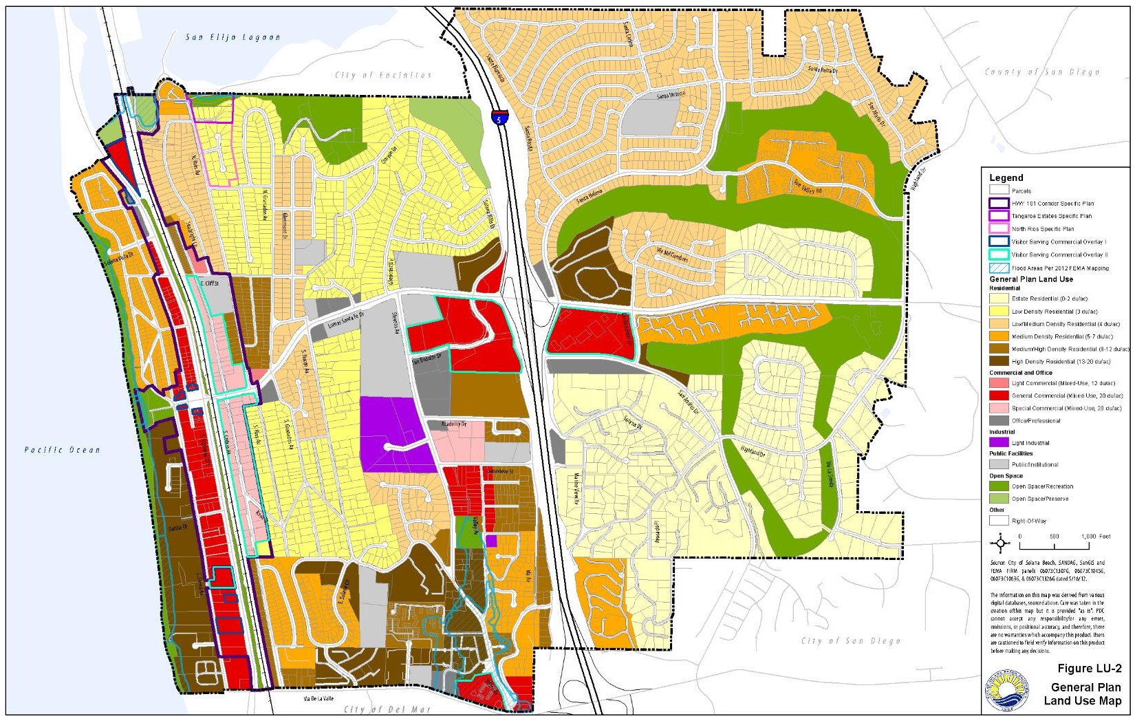
Low-Medium Density Residential: Under this category, single-family residences are to be developed at a maximum density of four dwelling units per acre. Other compatible uses such as accessory dwelling units, home occupations, religious institutions, educational institutions, parks and recreation facilities, and public utilities are permitted or conditionally permitted. The population density in these areas would be approximately nine persons per acre based on an average household size of 2.4 persons per unit. Most of the residential area in the northeast near Santa Helena and in the northwest near Seabright, Glenmont and Sonrisa are low-medium density.
Medium Density Residential: This category provides for single- and multi-family residential development within a density range of five to seven units per acre. Other compatible uses such as accessory dwelling units, home occupations, religious institutions, educational institutions, parks and recreation facilities, and public utilities are permitted or conditionally permitted. Population densities in these areas would be approximately 16 persons per acre assuming the maximum density of seven units per acre and an average household size of 2.4 persons per unit. This type of residential development is located along the south side of Lomas Santa Fe Drive (east of Los Banderos Road), along the coastal bluffs north of the Plaza, and in the Eden Gardens neighborhood.
Medium-High Density Residential: This category is for multi-family residential development within a density range of eight to twelve units per acre. Other compatible uses such as accessory dwelling units, home occupations, religious institutions, educational institutions, parks and recreation facilities, and public utilities are permitted or conditionally permitted. With an average household size of 2.4 persons per unit, population densities in these areas would be maximum of about 28 persons per acre assuming maximum development at twelve units per acre. Most of this type of residential development is located in the Eden Gardens neighborhood, and on the north end of Cedros Avenue.
High Density Residential: Multi-family residential development under this category will range between 13 and 20 dwelling units per acre. Other compatible uses such as accessory dwelling units, home occupations, religious institutions, educational institutions, parks and recreation facilities, and public utilities are permitted or conditionally permitted. Assuming maximum development and an average household size of 2.4 persons per unit, population densities in these areas could be as high as approximately 48 persons per acre. Most of Solana Beach’s high density residential development is located in the southwestern portion of the city (i.e., along the coastal bluffs south of the Plaza and in the area generally bounded by Via de la Valle, Solana Circle, Nardo Avenue, and Stevens Avenue).
Commercial/Mixed-Use Land Use Designations
Light Commercial: This category provides for a range of commercial uses that have minimal disturbance to nearby single-family residential neighborhoods. Residential uses are allowed as a secondary use in conjunction with permitted commercial uses at a maximum density of 12 units per acre. This equates to a population density of approximately 28 persons per acre assuming an average household size of 2.4 persons per unit. Other compatible uses such as religious institutions, educational institutions, public utilities, and parks and recreation facilities are permitted or conditionally permitted. Areas designated for light commercial are north of Lomas Santa Fe Drive between Rios Avenue and Granados Avenue, and north of Cliff Street between Cedros Avenue and Seabright Lane.
Special Commercial: Commercial development in this area would involve primarily a range of commercial and light industrial uses that have a minimal disturbance to nearby single-family residential neighborhoods. Residential uses are allowed as a secondary use in conjunction with permitted commercial uses at a maximum density of 20 units per acre. This equates to a population density of approximately 48 persons per acre assuming an average household size of 2.4 persons per unit. Other compatible uses such as religious institutions, educational institutions, public utilities, and parks and recreation facilities are permitted or conditionally permitted. The only locations in the city designated as Special Commercial include the area along Cedros Avenue and a site at the northeast corner of Stevens Avenue and Genevieve Street.
General Commercial: This category involves the development of resident and visitor serving commercial uses and retail uses of a larger scale than those permitted in Special Commercial areas such as grocery stores, drug stores, etc., but which still have a minimal disturbance to nearby residential neighborhoods. Residential uses are allowed as a secondary use in conjunction with permitted commercial uses at a maximum density of 20 units per acre. This equates to a population density of approximately 48 persons per acre assuming an average household size of 2.4 persons per unit. Other compatible uses such as religious institutions, educational institutions, public utilities, and parks and recreation facilities are permitted or conditionally permitted. The City’s General Commercial areas are located primarily along Highway 101 and along Lomas Santa Fe Drive.
Industrial Land Use Designation
Light Industry: This category provides for light manufacturing, mini-warehousing, and research and development uses. Other compatible uses such as public safety facilities, religious facilities, and public utilities and parking lots are also permitted or conditionally permitted. The only areas designated for light industrial use are along Stevens Avenue West and a site at the southeast corner of Valley Avenue and Hernandez Street.
Public/Institutional Land Use Designation
Public/Institutional: This category includes educational institutions, religious facilities, civic centers, public utilities, and other public uses. Most of these uses are located in the vicinity of the Lomas Santa Fe Drive/Stevens Avenue intersection.
Office/Professional Land Use Designation
Office/Professional: This category provides for professional offices (eg., medical and dental centers, financial services, etc.) and general office uses. Other compatible uses such as religious facilities, educational institutions, parks and recreation facilities, and public utilities are also permitted or conditionally permitted. Such uses are designated at sites along Lomas Santa Fe Drive, Stevens Avenue, Marine View Avenue, Santa Helena, and Pimlico Drive.
Open Space Land Use Designations
Open Space/Recreation: This category includes open space areas that are primarily designated for use by outdoor recreational activities (e.g., public parks, Lomas Santa Fe golf courses, etc.). Any structures constructed on land in this land use category shall be integral components of the recreational uses for the area and shall be at a scale that is compatible with the recreational site. Open Space/Recreation areas include beaches, beach [parks], City parks, and the golf courses located east of I-5. Owners of existing privately owned legal lots within this land use category may construct or alter one single family residential structure in accordance with the City’s zoning and other land use standards.
Open Space/Preserve: This land use category includes open space areas that are in natural condition or are restored or may be restored to natural condition, natural habitat for native vegetation or wildlife, or otherwise not developed. These areas shall remain undeveloped. The purpose of these Open Space/Preserve areas is to preserve and protect open space, scenic views, the natural environment, and habitat for aesthetic, conservation, and ecological purposes. Any use, activity, or improvement that is inconsistent or incompatible with or may impair or interfere with the purpose of this land use category to preserve and protect the value, desirability, attractiveness, and use of the land as open space, scenic views, and natural habitat is prohibited. No buildings, structures, facilities, or other improvements shall be constructed in Open Space/Preserve areas, including but not limited to any parking area and bathrooms, except the limited improvements set forth in the zoning regulations.
Other Land Use Considerations
Right-of-Way: This category provides for land uses that are limited to transportation, public utilities, recreation and other similar uses. It includes I-5, the railroad, and city roadways.
Floodplain: This designation identifies the 100-year floodplain limits as identified by the Federal Emergency Management Agency. These areas are subject to annual review.
Visitor Serving Commercial Overlays (VSCO) I and II: The purpose of the VSCO is to identify areas that are prime locations for tourist and visitor serving commercial uses, which must be redeveloped exclusively with visitor serving commercial uses (VSCO I) and primarily visitor-serving commercial uses (VSCO II). These overlay zones are implementation measures for the Local Coastal Program.
VSCO I: This land use overlay is intended to reserve sufficient land in appropriate locations exclusively for high-priority commercial recreation and visitor serving uses. The designation provides land to meet the demand for goods and services required primarily by the tourist population, as well as local residents who visit and recreate at the coast. Allowable uses include hotels, motels, restaurants, music venues, entertainment attractions, retail, and specialty/artisan retail commercial uses. Mixed-use development with office or residential above the ground level is also permitted. Existing uses may remain and any future redevelopment shall be consistent with the VSCO I overlay requirements. In addition to the above-listed uses, this site may also be developed with open space or public park uses compatible with the adjacent resources. The VSCO I designation applies to the following areas: the lots fronting Plaza Street from Highway 101 to Acacia Avenue; 717 South Highway 101; 621 South Highway 101; and at the triangle-shaped lot on the northern border of the city, located north of Ocean Street, on the east side of Highway 101. This triangle-shaped lot is adjacent to the San Elijo Lagoon Ecological Reserve.
VSCO II: This land use overlay identifies areas that are currently developed with visitor serving commercial uses that should be encouraged and promoted, but are not specifically restricted to these uses, as in the VSCO I land use designation. The uses include hotels, motels, restaurants, music venues, entertainment attractions, and specialty/artisan retail commercial uses. Mixed-use development with residential above the ground level is also permitted. Existing non-visitor serving uses such as light industrial uses, offices, and residential loft apartments may remain, but redevelopment of these sites should be for tourist and visitor-serving uses. The VSCO II designation applies to the following areas: the North and South Cedros Avenue Business Districts, the timeshare developments located at 535 South Highway 101 and north of Via de la Valle, west of Interstate 5; and the two commercially-zoned shopping plazas located east and west of Interstate 5 and south of Lomas Santa Fe Drive.
Scenic Area Overlay Zone: The Scenic Area Overlay Zone is intended to regulate development in areas with high scenic value. This Overlay Zone applies to areas of unique scenic value such as state scenic highways, scenic highway corridors, viewshed areas, and areas within 100 feet of significant recreational, historic, or scenic resources.
Hillside Overlay Zone: This Overlay Zone is intended to restrict the grading of natural slopes with a gradient of 25 percent or higher in order to preserve the natural topography and scenic qualities of Solana Beach, protect native coastal sage/chaparral and grassland habitat, preserve existing watersheds, and reduce potential environmental hazards such as soil erosion.
Floodplain Overlay Zone: The Floodplain Overlay Zone applies to all areas within the 100-year floodplain and is intended to ensure that development will not constitute an unreasonable, undesirable, or unnecessary obstruction to flood flow and that such development will not adversely impact coastal wetlands, riparian areas, or other sensitive habitat areas.
Scaled Residential Overlay Zone: This Overlay Zone is intended to preserve and enhance the existing community character and aesthetic quality of Solana Beach by protecting the traditional scale and seaside orientation of established residential neighborhoods.
Dark Sky Area Overlay Zone: The Dark Sky Overlay Zone establishes special lighting regulations to control excessive or unnecessary outdoor light emissions to preserve the traditional semi-rural character of designated “dark sky” neighborhoods.
Specific Plan Areas: This designation denotes areas that are covered by an adopted specific plan. Special land use and development regulations are identified within the applicable specific plan. As of the preparation of this General Plan, there are three adopted specific plans: the Highway 101 Corridor Specific Plan, the North Rios Specific Plan, and the Tangaroa Estates Specific Plan. Additional specific plans may be prepared and adopted in compliance with Section 65451 of the California Government Code.
Solana Beach School District. (2002-2012). About us. Retrieved December 13, 2012 from http://www.sbsd.k12.ca.us/domain/320.
Air Resources Board (2010). The Children’s Health Study. Retrieved December 12, 2012 from
http://www.arb.ca.gov/research/chs/chs.htm#new.
Harvard School of Public Health. (2011). Greenhouse Gases Pose Threat to Public Health. Retrieved December 12, 2012 from
http://www.hsph.harvard.edu/news/features/features/bernstein-greenhouse-gases-health-threat.html.
Environmental Protection Agency. (2011). Ozone - Good up high, bad nearby. Retrieved December 12, 2012 from
http://www.epa.gov/oar/oaqps/gooduphigh/good.html#3.
State Water Resources Control Board. (2009). Storm Water Pollution. Retrieved December 12, 2012 from
http://www.waterboards.ca.gov/water_issues/programs/outreach/erase_waste/swpollution.shtml.
Jackson, Richard. (n.d.). Creating a healthy environment: The Impact of the built environment on the public health. Sprawl Watch Clearinghouse Monograph Series. Retrieved December 12, 2012 from http://www.sprawlwatch.org/health.pdf.
San Diego Association of Governments (2010). 2050 Regional Growth Forecast.