IV. APPENDIX
Appendix 1.0
California Planning and Zoning Law – Article 8. Specific Plans
Article 8. Specific Plans
65450. Preparation of specific plan. After the legislative body has adopted a general plan, the planning agency may, or if so directed by the legislative body, shall, prepare specific plans for the systematic implementation of the general plan for all or part of the area covered by the general plan.
(Repealed and added by Stats. 1984, Ch. 1009.)
(Section 65450.1 repealed by Stats. 1984, Ch. 1009.)
65451. Content of specific plan. (a) A specific plan shall include a text and a diagram or diagrams which specify all of the following in detail:
(1) The distribution, location, and extent of the uses of land, including open space, within the area covered by the plan.
(2) The proposed distribution, location, and extent and intensity of major components of public and private transportation, sewage, water, drainage, solid waste disposal, energy, and other essential facilities proposed to be located within the area covered by the plan and needed to support the land uses described in the plan.
(3) Standards and criteria by which development will proceed, and standards for the conservation, development, and utilization of natural resources, where applicable.
(4) A program of implementation measures including regulations, programs, public works projects, and financing measures necessary to carry out paragraphs (1), (2), and (3).
(b) The specific plan shall include a statement of the relationship of the specific plan to the general plan.
(Repealed and added by Stats. 1984, Ch. 1009; Amended by Stats. 1985, Ch. 1199.)
65452. Optional subjects. The specific plan may address any other subjects which in the judgment of the planning agency are necessary or desirable for implementation of the general plan.
(Repealed and added by Stats. 1984, Ch. 1009.)
65453. Adoption/amendment procedure. (a) A specific plan shall be prepared, adopted, and amended in the same manner as a general plan, except that a specific plan may be adopted by resolution or by ordinance and may be amended as often as deemed necessary by the legislative body.
(b) A specific plan may be repealed in the same manner as it is required to be amended.
(Repealed and added by Stats. 1984, Ch. 1009; Amended by Stats. 1985, Ch. 1199.)
65454. Consistency with general plan. No specific plan may be adopted or amended unless the proposed plan or amendment is consistent with the general plan.
(Added by Stats. 1984, Ch. 1009.)
65455. Zoning, tentative, map, parcel map, and public works project consistency with specific plan. No local public works project may be approved, no tentative map or parcel map for which a tentative map was not required may be approved, and no zoning ordinance may be adopted or amended within an area covered by a specific plan unless it is consistent with the adopted specific plan.
(Added by Stats. 1984, Ch. 1009.)
65456. Fees and charges. (a) The legislative body, after adopting a specific plan, may impose a specific plan fee upon persons seeking governmental approvals which are required to be consistent with the specific plan. The fees shall be established so that, in the aggregate, they defray but as estimated do not exceed, the cost of preparation, adoption, and administration of the specific plan, including costs incurred pursuant to Division 13 (commencing with Section 21000) of the Public Resources Code. As nearly as can be estimated, the fee charged shall be a prorated amount in accordance with the applicant’s relative benefit derived from the specific plan. It is the intent of the Legislature in providing for such fees to charge persons who benefit from specific plans for the costs of developing those specific plans which result in savings to them by reducing the cost of documenting environmental consequences and advocating changed land uses which may be authorized pursuant to the specific plan.
(b) Notwithstanding Section 60016, a city or county may require a person who requests adoption, amendment, or repeal of a specific plan to deposit with the planning agency an amount equal to the estimated cost of preparing the plan, amendment, or repeal prior to its preparation by the planning agency.
(c) Copies of the documents adopting or amending the specific plan, including the diagrams and text, shall be made available to local agencies and shall be made available to the general public as follows:
(1) Within one working day following the date of adoption, the clerk of the legislative body shall make the documents adopting or amending the plan, including the diagrams and text, available to the public for inspection.
(2) Within two working days after receipt of a request for a copy of the documents adopting or amending the plan, including the diagrams and text, accompanied by payment for the reasonable cost of copying, the clerk shall furnish the requested copy to the person making the request.
(d) A city or county may charge a fee for a copy of a specific plan or amendments to a specific plan in an amount that is reasonably related to the cost of providing that document.
(Added by Stats. 1984, Ch. 1009; Amended by Stats. 1985, Ch. 338 and Ch. 1199; Amended by Stats. 1990, Ch. 1572.)
65457. CEQA exemption. (a) Any residential development project, including any subdivision, or any zoning change that is undertaken to implement and is consistent with a specific plan for which an environmental impact report has been certified after January 1, 1980, is exempt from the requirements of Division 13 (commencing with Section 21000) of the Public Resources Code. However, if after adoption of the specific plan, an event as specified in Section 21166 of the Public Resources Code occurs, the exemption provided by this subdivision does not apply unless and until a supplemental environmental impact report for the specific plan is prepared and certified in accordance with the provisions of Division 13 (commencing with Section 21000) of the Public Resources Code. After a supplemental environmental impact report is certified, the exemption specified in this subdivision applies to projects undertaken pursuant to the specific plan.
(b) An action or proceeding alleging that a public agency has approved a project pursuant to a specific plan without having previously certified a supplemental environmental impact report for the specific plan, where required by subdivision (a), shall be commenced within 30 days of the public agency’s decision to carry out or approve the project.
(c) This section does not supersede but provides an alternative procedure to Section 21080.7 of the Public Resources Code.
(Added by Stats. 1984, Ch. 1009.)
Appendix 2.0
RESOLUTION NO. 95-91 (Rescinded)
A RESOLUTION OF THE CITY COUNCIL OF THE CITY OF SOLANA BEACH, CALIFORNIA, AMENDING THE LAND USE ELEMENT OF THE SOLANA BEACH GENERAL PLAN BY CHANGING THE LAND USE PLAN DESIGNATION FOR CERTAIN PROPERTY AT THE NORTHERN END OF NORTH RIOS AVENUE FROM AGRICULTURE AND OPEN SPACE/RECREATIONAL TO LOW RESIDENTIAL AND OPEN SPACE/RECREATIONAL
APPLICANTS: NORTH RIOS DRIVE ASSOCIATES/NAKATANI
CASE NO.: 17-95-01
APPLICANTS: SKERRETT/ROYCE AND MELTON, TRUSTEES
CASE NO.: 17-95-03
WHEREAS, the above referenced applicants have submitted applications pursuant to Chapter 17.78 Solana Beach Municipal Code to amend the General Plan Land Use designation applicable to the properties owned by the applicants; and
WHEREAS, the applications have been duly processed according to applicable law; and
WHEREAS, on November 6, 13 and 28, 1995 the City Council held duly noticed public hearings to consider the above referenced applications and the Draft Environmental Impact Report prepared for the projects; and
WHEREAS, at the hearing the City Council received and considered evidence concerning the proposed application; and
WHEREAS, the City Council has considered and, on December 11, 1995 by separate resolution, certified the Final Environmental Impact Reports and supporting documents for the applications; and
WHEREAS, the City Council has found and determines that:
I. The Final EIR’s for the applications have been completed in compliance with CEQA. A Draft EIR was prepared and circulated for comments, pursuant to the process outlined in CEQA. The Draft EIR and Final EIR contained the required contents as described in CEQA.
II. The Final EIR’s were distributed to Council prior to the public hearing permitting the Council time to review their contents, and the Final EIR’s were discussed and considered by the Council during the public hearings on the EIR’s and the projects.
III. Changes or alterations have been required and incorporated, or will be required and incorporated as a condition of development approvals, into the project which will, or substantially, lessen the potentially significant environmental effect as identified in the Final EIR. The mitigation measures have been, or will be, incorporated into the conditions of approval for the projects.
WHEREAS, this decision is based upon the applications, evidence presented at the hearings, written correspondence and petitions submitted to the City Council, the Final EIR’s, visits to the sites and other legislative facts;
NOW THEREFORE, the City Council of the City of Solana Beach, California, does resolve as follows:
1. The foregoing recitations are true and correct.
2. The Land Use Plan of the Land Use Element of the Solana Beach General Plan is amended as follows:
A. The land use designation for that certain property described in the application submitted for Planning Department Case No. 17-95-01 (APN 263-280-18, 19, 29, 30) is hereby changed from Agriculture (“A”) to Low Density Residential (“LR”) (three dwelling units per acre) subject to the following provisions:
I. The change shall not be operative until a specific plan implementing this general plan designation has been fully processed and scheduled for approval by the City Council within two years from the date of this resolution and thereafter considered and approved by the City Council pursuant to California Government Section 65450 et seq.
II. The impacts on public schools serving residents of development of the subject property shall be fully mitigated by the owner and/or developer to the satisfaction of the Solana Beach School District and the San Dieguito Union High School District, as well as the City Council. Prior to approval of any tentative subdivision map for development of the subject property, the owner and/or developer shall submit proof of execution of school impact mitigation agreements, or other arrangements acceptable to the school districts.
III. The mitigation measures identified in the Final EIR, and its certifying resolution, shall be incorporated as conditions of approval of the specific plan, tentative subdivision map, and building permits as appropriate.
B. The land use designation for that certain property described in the application submitted for Planning Department Case No. 17-95-03 (APN 263-280-20) is hereby changed from Agricultural (“A”) and Open Space/Recreational (“OS/R”) to Low Density Residential (“LR”) (three dwelling units per acre) and Open Space/Recreational (“OS/R”) as more particularly shown on Exhibit 1 attached hereto and made a part hereof, subject to the following provisions:
I. The change shall not be operative until a specific plan implementing this general plan designation has been fully processed and scheduled for approval by the City Council within two years from the date of this resolution and thereafter considered and approved by the City Council pursuant to California Government Section 65450 et seq. If authorized by the specific plan prepared pursuant to this paragraph, the boundary of the OS/R and LR land use designations may be moved northerly to within 50 feet of the top edge of the bluff adjacent to the San Elijo Lagoon, consistent with the Final EIR and paragraph II, below.
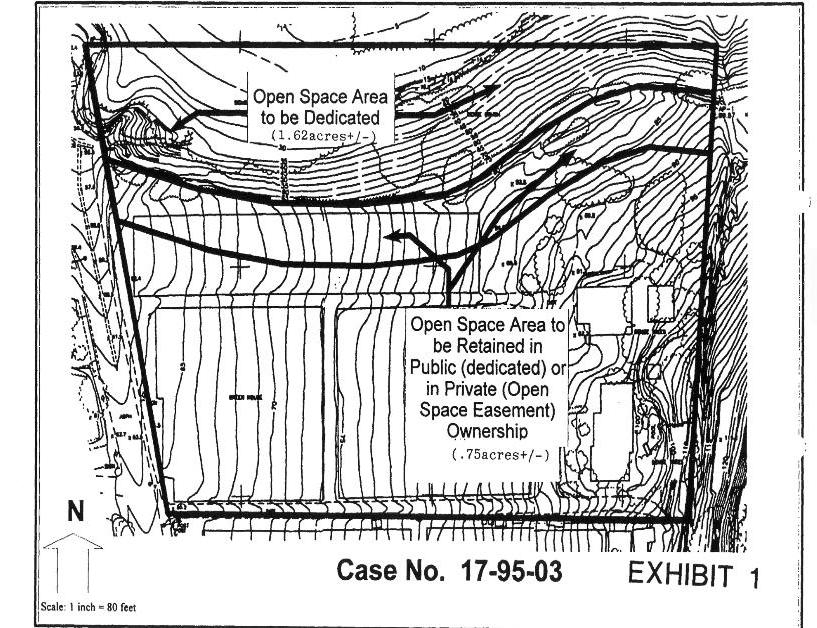
II. As a condition of any tentative subdivision map for development of the subject property, the owner shall dedicate, in fee, to an appropriate public agency or non-profit public benefit corporation approved by the City Council approximately 1.6 acres of the open space area as shown on Exhibit 2, attached hereto and made a part hereof. The remainder of the open space area shall be preserved and maintained as natural public or private open space by appropriate conditions of development. This paragraph shall not be construed to alter or amend the method for calculation of density pursuant to the provisions of Chapter 17.20 of the Solana Beach Municipal Code.
III. The impacts on public schools serving residents of development of the subject property shall be fully mitigated by the owner and/or developer to the satisfaction of the Solana Beach School District and the San Dieguito Union High School District, as well as the City Council. Prior to approval of any tentative subdivision map for development of the subject property, the owner and/or developer shall submit proof of execution of school impact mitigation agreements, or other arrangements acceptable to the school districts.
IV. The mitigation measures identified in the Final EIR, and its certifying resolution, shall be incorporated as conditions of approval of the development review permit, tentative subdivision map, and building permits as appropriate.
3. This resolution shall be effective upon adoption subject only to the possibility of referendum within 30 days following adoption.
PASSED AND ADOPTED at a regular meeting of the City Council of the City of Solana Beach, California, on the 12th day of December, 1995, by the following vote:
|
AYES: |
Councilmembers – Campbell, Dodson, Kellejian, Tompkins |
|
NOES: |
Councilmembers – Renteria |
|
ABSTAIN: |
Councilmembers – None |
|
ABSENT: |
Councilmembers – None |

Appendix 3.0
RESOLUTION NO. 95-90
A RESOLUTION OF THE CITY COUNCIL OF THE CITY OF SOLANA BEACH, CALIFORNIA, CERTIFYING THE ENVIRONMENTAL IMPACT REPORT (EIR) FOR THE PROPOSED SKERRETT SUBDIVISION, CASE NUMBER 17‑95‑03
WHEREAS, the Solana Beach City Council has before it a private application for an Amendment to the City General Plan, for a Rezoning action, and for a Tentative Subdivision Map (residential); and
WHEREAS, on February 21, 1995, the Solana Beach City Council held a duly noticed public hearing to ascertain the environmental concerns of the public relative to the proposed residential project; and
WHEREAS, the City Council has directed the preparation of an Environmental Impact Report (EIR) for the proposed General Plan Amendment, Rezoning and Residential Subdivision; and
WHEREAS, pursuant to the California Environmental Quality Act (CEQA) and Title 18, Environmental Review, of the Solana Beach Municipal Code, an Environmental Impact Report was prepared, and was advertised and circulated for public and agency review and comment; and
WHEREAS, following circulation, a Final Environmental Impact Report was prepared; and
WHEREAS, on November 13, 1995, the City Council of the City of Solana Beach held a duly noticed hearing to obtain further public input on the contents of the draft Environmental Impact Report; and
WHEREAS, on November 28, 1995, the City Council of the City of Solana Beach held a duly noticed public hearing pursuant to Title 18, Environmental Review, of the Solana Beach Municipal Code, to discuss the contents of the Final Environmental Impact Report; and
WHEREAS, this decision is based upon the public hearings on the Draft and Final EIR’s, upon the City Council’s own review of the Final Environmental Impact Report, and upon any information the City Council gathered by viewing the site and area as disclosed at the hearings.
NOW THEREFORE, the City Council of the City of Solana Beach, California, does resolve as follows:
A. That the foregoing recitations are true and correct.
B. That the City Council of the City of Solana Beach finds that the Final EIR has been completed in compliance with CEQA in that a Draft EIR was prepared and circulated for public review and comment, that proper notification was given advising the other agencies and the citizens of Solana Beach of the availability of the document, and that the appropriate notice of hearing of the discussion and certification of the Final EIR has been given.
C. That the Final EIR was presented to the City Council and the Council has reviewed and considered the information contained in the Final EIR. The Draft EIR and Final EIR were presented to the Council upon it availability to provide time for adequate review. The Council then reviewed the contents of the documents prior to the noticed hearing of certification and considered the information contained therein prior to rendering decisions on the project.
D. That changes or alterations have been required and incorporated into the project, or will be required and incorporated as a condition of development approval, which will avoid or lessen the potentially significant environmental effects as identified in the Final EIR. These measures include:
1. An open barrier such as that illustrated in Final EIR Figure 20 shall be used for all perimeter fencing on the west and north sides of the project. The design of the fencing shall be to the satisfaction of the Solana Beach Community Development Director.
2. The retaining wall along the western edge of the project shall be replaced with a landscaped crib wall. Any subsequent Tentative Map shall be conditioned such that the wall will be designed to the satisfaction of the Solana Beach Community Development Director.
3. Roofing materials shall be limited to earthen colors, and non-reflective materials. Roof line designs shall be architecturally varied, wherever possible, so as to provide diversity of appearance. The exteriors of the proposed residences, appurtenant structures and their future modifications, shall be limited to earthen colors.
4. Graded slopes on the north edge of lots bordering San Elijo Lagoon and the open space lot shall be planted with native shrubs. Species selected shall be those found naturally around the periphery of San Elijo Lagoon but shall not be species considered flash fuels. These plantings shall be maintained in perpetuity. Maintenance shall include periodic removal of invasive non-native species
5. Taller horticultural plantings (using native species where feasible) shall be placed adjacent to the homes on lots bordering San Elijo Lagoon in a manner that does not restrict the views of the residents of those lots but which does serve to break-up the mass and scale of the buildings.
6. Landscaping throughout the proposed subdivision shall be allowed subject to specified height limitations. The planting of tree species normally known to grow to heights in excess of 25 feet shall be prohibited, as shall be the planting of vegetation on any portion of a lot that would, in combination with that species known height at maturity, likely exceed 25 feet above the elevation of that lot’s building pad.
7. Appurtenant structures such as potting sheds, fences, satellite dishes, gazebos, etc., shall be prohibited on site wherever their placement would interrupt existing neighboring viewsheds.
8. The residential subdivision shall be responsible for half width improvements of North Rios Avenue as it fronts on the proposed subdivision. These improvements shall include curbs and gutters and shall be completed to the satisfaction of the City Engineer.
9. The residential subdivision shall provide appropriate stop controls at the project entrance (Rose Lane, see EIR Figure 4) to the satisfaction of the City Engineer.
10. Owner shall be required to enter into a School Impact Mitigation Agreement (“SIMA”) with the Solana Beach School District (“District”) which provides for adequate funding to construct and/or lease Owner’s proportionate share of school and support facilities necessary to serve new students generated by new residential development within the District’s boundaries. The actual dollar amount required for mitigation in the SIMA, on a per unit basis, depending on product type, shall be mutually agreed upon by Owner and District after good faith negotiations. It is expressly agreed by Owner and the City of Solana Beach (“City”) that Owner cannot and will not obtain final subdivision tract maps and City will not approve any final subdivision map for this Subdivision until a SIMA executed by both Owner and District is presented to the City. Funding required under the SIMA shall be paid prior to the issuance of any building permit and may, at the option of Owner and District, be in the form of a special tax levied under a community facilities district (“CFD”) to be formed by the District and annexed into by Owner. If Owner elects to annex into a CFD, Owner must have irrevocably voted to annex into the CFD prior to the approval of any final subdivision map by City. Owner agrees that the funding required under the SIMA shall not be subject to the limitations set forth in Government Code Section 65995(b)(1) or any future amendment thereto, or any other school fee limitations enacted after the approval of the tentative map for the project.
11. The development project will be required to fully mitigate the impact of its development on school capacity within the San Dieguito Union High School District. In this regard, the developer of the project shall, prior to obtaining a building permit for any lot, enter into a mitigation agreement with the affected school district to provide sufficient funds to construct facilities to fully meet the needs generated by the development.
12. The Home Owner’s Association of the proposed subdivision shall, through a contract with the City of Solana Beach or other appropriate entity, have the streets of the subdivision swept on a year-round monthly basis. Street sweeping shall include the street internal to the subdivision as well as the proximate part of North Rios Avenue. Street sweeping shall be by means of a vacuumized sweeper and at least three passes per monthly cycle shall be made along each specified curb. This street sweeping will be continued in perpetuity, for the life of the residential project.
13. The northern approximately 2.4 acres of the site, as shown in the attached Exhibit 1, shall be retained within the Open Space/Recreation Zone and Land Use Designation. The most northerly 1.62 acres of this Open Space/Recreation area shall be dedicated in fee to an appropriate public agency. The approximately 0.75 acres south of the top of the bluff, as shown in the attached Exhibit 1, shall be retained as an public or private open space to be maintained in natural open space by a home owner’s association of the proposed adjacent residential development, or through such other method as approved by the City Council. If retained in private ownership, an open space easement shall be recorded over this approximately 0.75 acres concurrent with recordation of any Final Subdivision Map.
14. The developer, shall, prior to the recordation of any final subdivision map, and in coordination with the County of San Diego Department of Parks and Recreation, and Department of Fish and Game, develop a plan for the removal of existing stands of non-native plants in San Elijo Lagoon below the North Rios Avenue cul-de-sac and/or within the area designated as Open Space/Recreation (see Exhibit 1) and their replacement with native plants suitable to the habitats present. The implementation of this plan, over its anticipated five year performance period, will be bonded for and funded by the developer of the Subdivision with the provision for either joint participation by or partial reimbursement from the developer of the adjacent North Rios Drive Subdivision. If the latter development were to proceed before this Subdivision, then provision shall be made for joint participation with or reimbursement of the developer of the North Rios Drive Subdivision. Participation in this mitigation measure by the two respective developers shall be on an equal basis in that it is anticipated that the effects of the two developments will be roughly proportional.
Implementation of the revegetation plan shall commence prior to the issuance of any grading permit for the subdivision. The revegetation plan shall include all of the non-native materials below the North Rios Avenue cul-de-sac, and within the retained Open Space/Recreation land use designation, a total area of from 2.25 to 2.75 acres.
15. In order to fulfill the City’s requirement for the maximal utilization of xeric landscaping materials, the project shall make use of native plant species whenever feasible. The use of native materials would limit in some small way the potential for additional non-native invasions of the lagoon and would provide a very limited amount of habitat within the bounds of the Subdivision.
16. The developer shall prepare, to the satisfaction of the Director Community Development, Covenants, Conventions and Restrictions (CC&R’s) for the proposed development shall include a condition notifying the home owner of the proximity of the lagoon, of the biological value of the lagoon, of the need to regulate subsidized predators and providing such additional information and educational material as may be appropriate. An effective homeowner notification mechanism with enforcement provisions shall be included.
17. CC&R’s for the proposed development shall include a condition restricting the ownership of cats to indoor animals and shall prohibit the feeding of cats outside of the residences.
18. CC&R’s for the proposed development shall include a condition restricting pet dogs to fenced yards unless otherwise leashed and requiring the home owner to clean up pet waste.
19. Additional testing of the site for adverse concentrations of agricultural chemicals shall be accomplished prior to the issuance of a grading permit. This study shall be conducted by a qualified consultant approved by the Community Development Director. If pesticide or other adverse residues are encountered a remediation plan shall be designed and implemented. If significant levels of pesticides or other toxins are encountered, the developer shall complete a risk assessment to address the possible migration of toxic components through foundations and building pads. These studies and assessments shall be sufficient to scientifically validate findings and address the pesticide/toxin exposure risks for the entire project.
20. Watering of freshly graded surfaces (both cut and fill) shall be conducted to the maximum extent allowed by the on site engineering geologist in order to control fugitive dust. Additional use of water based suppressant and dust control mitigation strategies/chemicals shall be required to absolutely minimize fugitive dust transport outside of the project’s boundaries.
21. The grading contractor shall be notified in writing, prior to the issuance of grading permits, of the presence and potential presence of chlorinated pesticides, including DDT. The grading and excavation plans shall include an on-site monitoring program to determine both personnel exposure limits (PEL’s) as well as potential for off-site disbursing of airborne or solidborne pesticides.
22. Prior to grading of the site a “mounding” study shall be conducted to determine the potential for groundwater rise beneath the finished subdivision. Such a study requires determination of the depth to the existing perched water table, determination of the hydrological conductivity of the water bearing soils (Bay Point Formation), and completion of appropriate computer modeling to ascertain the potential extent of groundwater rise under future conditions.
23. Prior to grading of the site an comprehensive engineering geology study of the site shall be conducted to the satisfaction of the Solana Beach City Engineer. This study shall, at a minimum, be based on additional subsurface investigations and shall provide specific recommendations for grading of the site and for the design of all structural components proposed. The comprehensive engineering geology study for the site shall include a detailed assessment (including deep borings) of the stability of the bluff face. This evaluation shall be completed to the satisfaction of the Solana Beach City Engineer.
24. Only grading equipment fitted with exhaust silencers will be utilized in the grading of the project site. Older equipment, lacking or not retrofitted with modern exhaust silencers shall not be permitted. All tracked vehicles shall be maintained on a daily basis. Special attention shall be paid to the lubrication of the tracks so as to prevent excessive noise generation. Construction activities shall be limited to the hours of 7:00 a.m. to 5:00 p.m., Monday through Friday, including maintenance of grading equipment.
25. Grading shall be limited to the non-rainy season, roughly from 1 April through 31 October.
26. All graded slopes will be sandbagged during the rainy season to prevent any drainage across the face of the slope.
27. All finished grades will be constructed so as to direct future drainage away from cut and fill slopes.
28. Any graded pads left undeveloped during the rainy season shall be constructed in a manner (utilizing sandbags and other devices as necessary) that they will act as detention basins. The surface of the pad shall act to store runoff, releasing it to the street drains only at a rate less than or equal to the natural runoff rate.
29. Landscaping (temporary if necessary) shall be installed on all cut and fill slopes prior to the onset of the rainy season. Similarly, graded pads that are to be left vacant for an appreciable period of time during the rainy season shall also be temporarily landscaped with ground cover.
30. Equipment deliveries, the parking of construction equipment, the parking of the personal vehicles of construction workers, and of related vehicles shall be limited to within the bounds of the subdivision during construction
31. Lay down storage and vehicle parking shall be limited to areas within the subject property (such as the finished interior streets) following initial grading.
32. A qualified paleontological consultant shall be retained prior to the initiation of grading activities, the consultant shall attend all pre-grade meetings, the paleontological consultant shall monitor all excavations below the weathered zone of the site, if significant fossil materials are encountered during grading, adequate time shall be afforded to the consultant to remove the materials, all fossil materials so recovered shall be curated at an appropriate scientific institution, approved by the Community Development Director, where they shall be made available for future study and reference by qualified professionals, and a brief report of the findings and their disposition shall be made to the City Council.
33. Zoning Ordinance criteria establishing “Dark Sky” standards shall be utilized to eliminate unnecessary night lighting intrusion into the lagoon.
E. That the Final Environmental Impact Report is hereby certified in accordance with the California Environmental Quality Act and Title 18 of the Solana Beach Municipal Code.
F. The Mitigation Monitoring Program is hereby adopted and shall commence as specified, prior to recordation of any Final Subdivision Map over the property identified in the Final Environmental Impact Report.
PASSED AND ADOPTED at a regular meeting of the City Council of the City of Solana Beach, California, held on the 11th day of December, 1995, by the following vote:
|
AYES: |
Councilmembers – Campbell, Dodson, Kellejian, Renteria, Tompkins |
|
NOES: |
Councilmembers – None |
|
ABSTAIN: |
Councilmembers – None |

Appendix 4.0
RESOLUTION NO. 96-94
A RESOLUTION OF THE CITY COUNCIL OF THE CITY OF SOLANA BEACH, CALIFORNIA, AMENDING THE LAND USE ELEMENT OF THE SOLANA BEACH GENERAL PLAN BY CHANGING THE LAND USE PLAN DESIGNATION FOR CERTAIN PROPERTY AT THE NORTHERN END OF NORTH RIOS AVENUE FROM AGRICULTURE AND OPEN SPACE/RECREATIONAL TO LOW RESIDENTIAL AND OPEN SPACE/RECREATIONAL
APPLICANTS: SKERRETT/ROYCE AND MELTON, TRUSTEES
CASE NO.: 17-96-17 (Prior Case No. 17-95-03)
APPLICANTS: JENSEN, NAKATANI AND RIOS DRIVE ASSOCIATES
CASE NO.: 17-96-18 (Prior Case No. 17-95-01)
WHEREAS, the above referenced applicants have submitted applications pursuant to Chapter 17.78 Solana Beach Municipal Code to amend the General Plan Land Use designation applicable to the properties owned by the applicants; and
WHEREAS, the applications have been duly processed according to applicable law; and
WHEREAS, on September 3, 1996, the City Council held duly noticed public hearings to consider the above referenced applications; and
WHEREAS, at the hearing the City Council received and considered evidence concerning the proposed application; and
WHEREAS, the City Council has considered and, on December 11, 1995 by separate resolution, certified the Final Environmental Impact Reports and supporting documents for the applications; and
WHEREAS, the City Council has found and determined that:
I. The Final EIR’s for the applications have been completed in compliance with CEQA. A Draft EIR was prepared and circulated for comments, pursuant to the process outlined in CEQA. The Draft EIR and Final EIR contained the required contents as described in CEQA.
II. The Final EIR’s were distributed to Council prior to the public hearing permitting the Council time to review their contents, and the Final EIR’s were discussed and considered by the Council during the public hearings on the EIR’s and the projects.
III. Changes or alterations have been required and incorporated, or will be required and incorporated as a condition of development approvals, into the project which will, or substantially, lessen the potentially significant environmental effect as identified in the Final EIR. The mitigation measures have been, or will be, incorporated into the conditions of approval for the projects.
WHEREAS, this decision is based upon the applications, evidence presented at the hearings, written correspondence and petitions submitted to the City Council, the Final EIR’s, visits to the sites and other legislative facts;
NOW THEREFORE, the City Council of the City of Solana Beach, California, does resolve as follows:
1. The foregoing recitations are true and correct.
2. The Land Use Plan of the Land Use Element of the Solana Beach General Plan is amended as follows:
A. The land use designation for that certain property described in the application submitted for Planning Department Case No. 17-96-18 (APN 263-280-18, 19, 29, 30) is hereby changed from Agriculture (“A”) to Low Density Residential (“LR”) (three dwelling units per net acre) subject to the following provisions:
I. A specific plan implementing this general plan designation shall be submitted, processed and scheduled for approval by the City Council by the first Council Meeting in May, 1998, thereafter considered and approved by the City Council pursuant to California Government Section 65450 et seq. This time period may be extended by the City Council for good cause. The specific plan shall include provisions to implement the following guidelines.
a. Subject project shall have no more than 24 lots/single family homes plus the existing home at the southeast corner of the property, with a minimum lot size of 14,000 square feet, with streets and lot frontages meeting all City standards.
b. In lieu of revegetation as specified in the FEIR, the Applicant shall pay an in-lieu fee to be placed into a fund administered by the San Elijo Lagoon Conservancy for appropriate lagoon conservation measures. This fund will be kept separate from all other funds of SELC and can be audited at any time. The fee shall equal one half the approximate cost of the proposed revegetation plan, and the amount shall be specified in the Specific Plan.
c. At the Applicant’s request, the Applicant shall satisfy its Affordable Housing obligation off-site under Chapter 17.70 of the Zoning Ordinance without increasing the number of single family homes.
d. Improvements to the storm drain catch basin at the north end of North Rios Avenue to mitigate effects on the Lagoon shall be developed to the satisfaction of the City Engineer.
e. CC&R’s for the project shall be submitted for approval by the City Attorney prior to the recordation of any final subdivision map of the property and shall contain provisions relating to the following:
(1) Developer shall coordinate with San Elijo Lagoon Conservancy a list of plant species which shall not be planted within specific portions of the subject project.
(2) Pools and Spas shall never be drained into streets, storm drains, backyards or over fences.
(3) Street sweeping as required by the FEIR or more frequently as determined appropriate by the City Engineer shall be done at the expense of the H.O.A.
(4) Developer shall distribute General Rules provided by the San Elijo Lagoon Conservancy to all new homeowners for their educational use.
(5) No feeding of pet cats outdoors.
(6) Dogs shall be kept on a leash when outside their fenced yard.
(7) Meandering path shall be planted by developer and maintained by H.O.A.
(8) Tree heights shall be limited to 25 feet or roof top height, whichever is less.
II. The impacts on public schools serving residents of development of the subject property shall be fully mitigated by the owner and/or developer to the satisfaction of the Solana Beach School District and the San Dieguito Union High School District, as well as the City Council. Prior to approval of any tentative subdivision map for development of the subject property, the owner and/or developer shall submit proof of execution of school impact mitigation agreements, or other arrangements acceptable to the school districts.
III. The mitigation measures identified in the Final EIR, and its certifying resolution, shall be incorporated as conditions of approval of the specific plan, CC&R’s, tentative subdivision map, and building permits as appropriate.
B. The land use designation for that certain property described in the application submitted for Planning Department Case No. 17-96-17 (APN 263-280-20) is hereby changed from Agricultural (“A”) and Open Space/Recreational (“OS/R”) to Low Density Residential (“LR”) (three dwelling units per acre) and Open Space/Recreational (“OS/R”) as more particularly shown on Exhibit A attached hereto and made a part hereof, subject to the following provisions:
I. A specific plan implementing this general plan designation shall be submitted, processed and scheduled for approval by the City Council by the first Council Meeting of May, 1998, and thereafter considered and approved by the City Council pursuant to California Government Section 65450 et seq. This time period may be extended by the City Council for good cause. The specific plan shall include provisions to implement the following conditions:
a. Subject project shall have 3 units per net acre with a maximum of 9 lots/single family homes. Developer shall use its best efforts to create a minimum lot size of 12,000 square feet, with lots averaging 14,000 square feet.
b. Six lots only shall be created adjacent to the Lagoon, with building setbacks as follows:
Two (2) lots at a minimum building setback of 65 feet from the bluff-top
Four (4) lots at a minimum building setback of 75 feet from the bluff-top
c. Developer shall dedicate to the public or to an appropriate entity in trust for the public the first 25 feet of property south of the bluff-top for a permanent open space buffer. Developer shall dedicate the property north of the bluff-top to the appropriate County or State agency as Permanent Public Parkland.
d. The area 25 feet to the south of the open space buffer referenced in paragraph “c” above shall be established as Open Space for native species and shall be commonly owned and maintained by the development H.O.A.
e. The 50-foot public and private open space buffer referenced in paragraphs “c” and “d” above, shall be planted with native vegetation consistent with a list of plant species mutually agreed upon between the San Elijo Lagoon Conservancy and Developer, and approval by the Community Development Director. Developer shall install, at its sole expense, any drip irrigation systems necessary to establish and maintain said vegetation. The Homeowner’s Association shall maintain said area as permanent biological open space, consistent with a natural and native biohabitat in perpetuity. No structures, public access, fences, play equipment, pets or any active use whatsoever shall be allowed therein, except for one fence adjacent and parallel to North Rios Avenue and necessary drainage structures as specified in the Specific Plan.
f. In lieu of revegetation as specified in the FEIR, the Applicant shall pay an in-lieu fee to be administered by the San Elijo Lagoon Conservancy for appropriate Lagoon conservation measures. This fund will be kept separate from all other funds of SELC and can be audited at any time. The fee shall be equal to one-half the approximate cost of the proposed revegetation plan, and the amount shall be specified in the Specific Plan.
g. CC&R’s for the project shall be submitted for approval by the City Attorney prior to recordation of any final subdivision map for the property and shall contain provisions relating to all matters referenced in paragraph 2.A.I.e. (I) – (6) inclusive and 2.A.I.e. (8) above.
II. The impacts on public schools serving residents of development of the subject property shall be fully mitigated by the owner and/or developer to the satisfaction of the Solana Beach School District and the San Dieguito Union High School District, as well as the City Council. Prior to approval of any tentative subdivision map for development of the subject property, the owner and/or developer shall submit proof of execution of school impact mitigation agreements, or other arrangements acceptable to the school districts.
III. The mitigation measures identified in the Final EIR, and its certifying resolution, shall be incorporated as conditions of approval of the development review permit, tentative subdivision map, and building permits as appropriate.
3. This resolution shall be effective upon adoption subject only to the possibility of referendum within 30 days following adoption. For the purposes of any referendum, action or to challenge the validity of this resolution, Paragraphs A and B of Section 2, hereof, shall be severable and may be separately subject to referendum or legal action.
PASSED AND ADOPTED at a regular meeting of the City Council of the City of Solana Beach, California, on the 3rd day of September, 1996, by the following vote:
|
AYES: |
Councilmembers – Dodson, Kellejian, Renteria, Tompkins |
|
NOES: |
Councilmembers – None |
|
ABSTAIN: |
Councilmembers – None |
|
ABSENT: |
Councilmembers – Campbell |

Appendix 5.0
ORDINANCE NO. 224
AN ORDINANCE OF THE CITY COUNCIL OF THE CITY OF SOLANA BEACH, CALIFORNIA AMENDING THE OFFICIAL ZONING MAP FOR THE CITY TO CHANGE THE ZONING DESIGNATION FOR CERTAIN REAL PROPERTY LOCATED NEAR THE NORTHERN END OF NORTH RIOS AVENUE NORTH OF SEABRIGHT LANE FROM OPEN SPACE AND AGRICULTURE TO OPEN SPACE AND LOW RESIDENTIAL
APPLICANT: SKERRETT, ROYCE AND MELTON, TRUSTEES
CASE NO.: 17-96-17 (Prior Case No. 17-95-03)
WHEREAS, the above referenced applicants have submitted applications pursuant to Chapter 17.76 Solana Beach Municipal Code to amend the Zoning Ordinance classification applicable to the properties owned by the applicants; and
WHEREAS, the applications have been duly processed according to applicable law; and
WHEREAS, on September 3, 1996, the City Council held duly noticed public hearings to consider the above referenced applications; and
WHEREAS, at the hearing the City Council received and considered evidence concerning the proposed application; and
WHEREAS, the City Council has considered and, on December 11, 1995 by separate resolution, certified the Final Environmental Impact Reports and supporting documents for the applications; and
WHEREAS, the City Council has found and determined that:
I. The Final EIR’s for the applications have been completed in compliance with CEQA. A Draft EIR was prepared and circulated for comments, pursuant to the process outlined in CEQA. The Draft EIR and Final EIR contained the required contents as described in CEQA.
II. The Final EIR’s were distributed to Council prior to the public hearing permitting the Council time to review their contents, and the Final EIR’s were discussed and considered by the Council during the public hearings on the EIR’s and the projects.
III. Changes or alterations have been required and incorporated, or will be required and incorporated as a condition of development approvals, into the project which will, or substantially, lessen the potentially significant environmental effect as identified in the Final EIR. The mitigation measures have been, or will be, incorporated into the conditions of approval for the projects.
IV. The proposed amendment is consistent with the proposed General Plan Amendment.
V. The proposed amendment would not be detrimental to the public interest, health, safety convenience or welfare of the City.
WHEREAS, this decision is based upon the applications, evidence presented at the hearings, written correspondence and petitions submitted to the City Council, the Final EIR’s, visits to the sites and other legislative facts;
NOW THEREFORE, the City Council of the City of Solana Beach, California, does ordain as follows:
SECTION 1. The zoning designation for Assessor Parcel Number 263-280-20 is changed from Open Space and Agriculture to Open Space and Low Residential, subject to and conditioned upon the preparation of a specific plan as set forth in the concurrently adopted General Plan Amendment City Council Resolution.
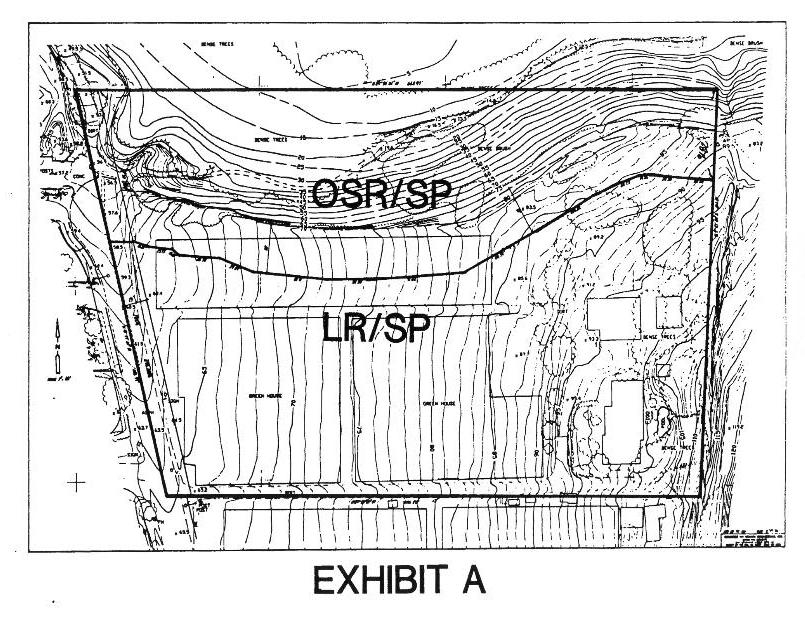
SECTION 2. The Community Development Director shall amend the Official Zoning Map for the City to reflect the new zoning classification, including the specific plan requirement, for the above described real property. The specific plan requirement may be shown on the zoning map as follows: “LR/SP” and “OSR/SP”.
SECTION 3. The subject property and the zoning classification change are shown for convenience on the diagram attached hereto as Exhibit A.
EFFECTIVE DATE: This ordinance shall be effective thirty (30) days after the date of its adoption. Within fifteen (15) days after its adoption, the City Clerk shall cause this ordinance to be published in a newspaper of general circulation within the City of Solana Beach as required by law.
INTRODUCED at a regular meeting of the City Council of the City of Solana Beach held on the 3rd day of September, 1996, and thereafter.
PASSED AND ADOPTED at a regular meeting of the City Council of the City of Solana Beach held on the 17th day of September, 1996, by the following vote:
|
AYES: |
Councilmembers – Campbell, Dodson, Kellejian, Renteria, Tompkins |
|
NOES: |
Councilmembers – None |
|
ABSTAIN: |
Councilmembers – None |
|
ABSENT: |
Councilmembers – None |

Appendix 6.0
AGREEMENT
This Agreement is made by and between Ruth and Russel Skerrett, (herein referred to as “Applicants”) and Save Old Solana, (herein referred to as “SOS”) and San Elijo Lagoon Conservancy, (herein referred to as “SELC”).
RECITALS
This Agreement is made with reference to the following facts and circumstances:
A. Applicants have an interest in real property subject to Resolution No. 95-91 of the Solana Beach City Council approved on December 11, 1995. Said Resolution was the approval of a General Plan Amendment providing for the residential development of such real property. Said Resolution was referended through the efforts of S.O.S.
B. Applicants have revised plans for the proposed development of the real property and have worked with SOS and SELC to find an acceptable general development plan.
C. The parties have reached agreement with regard to the general parameters of the development and have asked the City Council to rescind Resolution No. 95-91 with the intent of requesting approval of a new resolution approving a General Plan Amendment for the proposed revised general development plan.
D. SOS and SELC have agreed to support a new Resolution which is strictly consistent with the terms of this Agreement.
E. SOS and SELC do reserve the right to fully participate in the Specific Plan process and make constructive comments on unresolved issues.
In consideration of the Recitals:
1. Applicants agree to request that the City Council rescind Resolution No. 95-91 and submit a revised General Plan Amendment request which is significantly different from Resolution No. 95-91 to the City Council for approval on September 3, 1996.
2. SOS and SELC agree to support approval of the revised General Plan Amendment provided the new Resolution contains the following:
1. Subject project shall have 3 units per net acre with a maximum of 9 lots/single family homes, Developer shall use it’s best efforts to create a minimum lot size of 11,000 square feet, with lots TS averaging 12,000 square feet, with the entire project being subject to the Specific Plan Process.
2. Six lots only shall be created adjacent to the lagoon, with building set backs as follows:
a) Two, (2), lots at a minimum building setback of 65 feet from the blufftop.
b) Four, (4), lots at a minimum building setback of 75 feet from the blufftop.
3. Developer shall dedicate the first 25 feet of property south of the blufftop as permanent Open Space Buffer, and all property which Developer owns to the north of the blufftop to the appropriate agency as dedicated Permanent Public Park Land. The next 25 feet to the south shall be established as commonly owned, biological open space and maintained by the development HOA establishing a total biological buffer of 50 feet from the bluff edge.
4. Said 50 feet of property referenced in paragraph 3 above, shall be planted with native vegetation consistent with a list of plant species mutually agreed upon between SELC and Developer. Developer shall install, at it’s sole expense, any drip irrigation systems necessary to establish and maintain said vegetation. The Homeowners Association shall maintain said area as permanent biological open space, consistent with a natural and native biohabitat in perpetuity. No structures, public access, fences, play equipment, pets or any active use whatsoever shall be allowed therein.
5. The Homeowners Association shall enforce CC&Rs with the authority to require the removal/cessation of any improper activities or actions (construction or otherwise), by homeowners. Removal shall be performed at homeowners sole expense and carry substantial fines. Deed restrictions shall be created to assure that par.3, 4 and 5 are enforced.
6. Developer, SELC and SOS agree to use their best efforts to replace the required revegetation mitigation plan with an in-lieu fee to be administered by SELC. This fund will be kept separate from all other funds of SELC and can be audited at any time. Good faith negotiations shall arrive at a fee equal to the approximate cost of the proposed revegetation plan previously adopted. Applicant shall be responsible for 50% of said total fee. Broadmoor/Rios Partners/Nakatani shall be responsible for 50%.
7. CC&Rs and additional mitigation measures shall include those items in Resolution 95-91, and incorporate the following items into the appropriate enforceable written instruments:
a) Developer shall coordinate with SELC a list of plant species which shall not be planted within specific portions of the subject project.
b) Pools and Spas shall never be drained into streets, storm drains, backyards or over fences.
c) Street sweeping shall be implemented as mutually agreed upon by SELC and Developer.
d) Developer shall distribute General Rules provided by SELC to all new homeowners for their educational use.
e) No feeding of pet cats outdoors.
f) Dogs shall be kept on a leash when outside their fenced yard.
8. Developer shall not be required to pay any further application fees whatsoever for the significantly different resolution to replace 95-91.