


Chapter 13.32
WATERSHED AND WATER SUPPLY STANDARDS
Sections:
Article I. General Provisions
13.32.050 Prevailing provisions.
13.32.080 Entry and inspection.
13.32.090 Violations – Penalties.
Article II. Definitions
13.32.100 Rules of construction.
13.32.110 General terms defined.
Article III. Watershed
13.32.130 Establishment of the watershed.
13.32.160 Unlawful to cause injury or damage.
Article IV. Activity Within the Watershed
13.32.180 Permit required – Application.
13.32.190 Activities requiring a City watershed permit.
13.32.200 Activities not requiring a City watershed permit.
Article V. Administration and Enforcement
13.32.220 Submittal requirements.
13.32.230 Review and permitting procedures.
13.32.240 Permit expiration and renewal.
13.32.250 Permit closure and release of financial warranty.
13.32.260 Permit temporary cessation status.
13.32.280 Issuance of permit – Permit conditions.
13.32.290 Inspectors/inspections.
13.32.310 Permit transferability.
13.32.330 Fees and review costs.
Article VI. Appeal
13.32.350 Appeal of administrative decision.
13.32.360 Appeal of City Council’s decision.
Article VII. Appendices
Appendix C Water Quality Standards
Prior legislation – Ord. 3961.
Article I. General Provisions
13.32.010 Short title.
These regulations may be cited as the “watershed protection regulations” or generally as “watershed regulations.”
(Res. 115-07 § XX-1, 7-30-07)
13.32.020 Intent.
The City Council finds that the maintenance and protection of an adequate water supply of the highest quality and quantity is essential to the public health, safety and welfare of the citizens of the City, and that the City’s water supply and waterworks shall be protected from pollution, impairment, injury or damage.
These regulations shall be periodically reviewed and updated to reflect new technologies and/or applicable State and federal regulations.
(Res. 115-07 § XX-2, 7-30-07)
13.32.030 Authority.
Pursuant to the Constitution, the Charter and applicable law, the City may enact ordinances and regulations for the purpose of maintaining and protecting the City’s waterworks from injury and to protect the water from pollution in lands and territory occupied by such waterworks and over the streams or sources, including groundwater, from which the water is taken for five miles above the point from which it is taken, pursuant to § 31-15-707(l)(b), C.R.S.
All powers and protections stated herein are applicable to all property owned by the City contiguous to the watershed boundary.
(Res. 115-07 § XX-3, 7-30-07)
13.32.040 Severability.
If any section, subsection, paragraph, clause, phrase or provision of these regulations shall be held or adjudged to be invalid by a court of competent jurisdiction, then the validity of the balance of the watershed regulations shall not be affected in whole or in part.
(Res. 115-07 § XX-4, 7-30-07)
13.32.050 Prevailing provisions.
The City’s authority over proposed activities within the watershed, not on land owned in fee simple by the City, shall be exercised concurrently with Mesa County, the United States Department of Agriculture, the United States Forest Service (USFS), the United States Department of the Interior and the United States Bureau of Land Management (BLM), consistent with and pursuant to the City’s jurisdiction as authorized by law and implemented by these regulations. The City’s authority shall be construed as broadly as is consistent with established principles of law. For all proposed activities on land owned in fee simple by the City, or if any federal, State or local entity defers or declines to exercise its applicable authority, if any, for any proposed activity within the watershed, the City’s review authority shall occur prior to the commencement of any proposed activity subject to these regulations.
(Res. 115-07 § XX-5, 7-30-07)
13.32.060 Interpretation.
In their application and interpretation the provisions of these regulations shall be held to be minimum requirements. These regulations do not repeal, abrogate, annul or in any way impair or interfere with existing provisions of private or intergovernmental agreements. Where these regulations impose a greater restriction than that imposed by prior or existing provisions of law, contract or deed, the provisions of these regulations shall control.
(Res. 115-07 § XX-6, 7-30-07)
13.32.070 Legal action.
(a) The City Attorney is authorized to file suit against and/or to prosecute in the Municipal Court any person alleged to violate in whole or in part any provision of these regulations.
(b) Any employee(s) of the Utilities and Streets Systems Department that is so authorized by the City Manager may detain and hold for further disposition any person in violation of these regulations.
(Res. 115-07 § XX-7, 7-30-07)
13.32.080 Entry and inspection.
The City may enter and inspect any property within the watershed and under the jurisdiction of these regulations at reasonable hours for the purpose of determining if any activity is in violation of the provisions hereof and/or is in violation or noncompliance with any permit issued hereunder. In the absence of a bona fide emergency, the City will follow all regulations pertaining to motorized travel and safety procedures when doing inspection.
(Res. 115-07 § XX-8, 7-30-07)
13.32.090 Violations – Penalties.
(a) It is unlawful to engage in any activity not in compliance with these regulations or any amendment thereto and/or the permit requirements hereof. Any person, corporation or other legal entity, either as owner, lessee, permittee, occupant or otherwise, who violates any provision of these regulations and/or who engages in any activity not in compliance with these regulations shall be charged with a misdemeanor.
(b) Any person, corporation or other legal entity, upon conviction of a violation of these regulations, shall be punished by a fine or imprisonment or both pursuant to the limits established in GJMC 1.04.090.
(c) Any person, corporation or other legal entity shall be guilty of a separate offense for each and every day during any portion of which any violation of these regulations is committed, continued or permitted.
(d) Nothing herein shall limit the City from seeking any other remedies available by law or in equity, including but not limited to injunctive relief, the recovery of damages and the payment of costs and reasonable attorneys’ fees. All remedies shall be cumulative.
(Ord. 4424 § 3, 5-5-10; Res. 115-07 § XX-9, 7-30-07)
Article II. Definitions
13.32.100 Rules of construction.
For the purposes of these regulations, the words and phrases set forth herein shall have the meanings respectively ascribed to them and, in addition, whenever appropriate with the context, words used in the present tense include the future tense, words used in the singular include the plural and vice versa, the word “shall” is always mandatory and the word “may” is permissive.
(Res. 115-07 § XX-21, 7-30-07)
13.32.110 General terms defined.
Whenever the following words or phrases are used, they are defined as follows:
Acceptable use means any activity within the watershed that is not required to provide a watershed permit, pursuant to GJMC 13.32.180.
Activity means any excavating, filling, grading, surfacing, construction or activity, other than noncommercial gardening or landscaping, which changes or enlarges the basic character or the use of the land upon which the activity occurs.
City means the City of Grand Junction and, where appropriate, an officer, employee or authorized agent of the City of Grand Junction.
City Council or Council means the City Council of the City of Grand Junction.
City-owned lands in fee simple means fee simple ownership of real property.
Confined animal feeding operations means an animal feeding operation (AFO) at a lot or facility where animals are stabled or confined for a total of 45 days or more in any 12-month period and crops or vegetative growth are not maintained in the normal growing season over the lot or facility.
Ditch means a small to moderate depression created to channel water.
Domestic use means the construction of a single-family residence of less than 10,000 square feet in total interior square feet construction and maintenance of driveways, landscaping and accessory barns and sheds in connection with single-family residence; the maintenance, cutting and clearing of necessary trees and vegetation to accomplish the same; and treatment of noxious weeds and fire fuels management on the single-family residential property.
Drain means the natural or artificial removal of surface and subsurface water from a given area.
Drilling or drilling operations means drilling for water, oil, gas, or other natural resources, and includes grading, construction, and traffic activities associated with the drilling.
Excavating means the intentional movement of earth leaving any cut bank over three feet in height or a movement of material in excess of 10 cubic yards.
Filling means the intentional movement of earth that results in any earth bank over two feet in height or filled earth over two feet deep, or artificial addition of earth above a line sloping up at a grade of one vertical unit to five horizontal units from the ground before the filling.
Grading means the intentional movement of over five cubic yards of material; movement of any earth or material that changes the natural flow of surface water, or affects or creates a drainage channel; pioneering of a road, cutting or clearing of trees and shrubbery that results in creating a roadway or driveway in excess of 25 feet in length; or the use of vehicles or keeping of any animals upon any land that could reasonably lead to a movement of five cubic yards of material within any five-year period.
Groundwater means any water existing in a saturated or unsaturated state in the subsurface soils and rock.
Hazardous means a condition, situation, or substance that has the potential to cause harm to humans and the ecosystem.
Hazardous substance means any material as described in 40 CFR 300.5.
Impact means any alteration or change resulting directly or indirectly from an action.
Mining means any activity that involves the exploration for or the development (excavation or extraction) of soils, rock, coal, minerals or other geologic materials.
Mitigation means processes or methods which:
(1) Avoid an impact upon the land by evaluating alternatives and redesigning an activity;
(2) Minimize an impact upon the land by substantially limiting the scope of an activity;
(3) Rectify an impact upon the land through the use of remediation, rehabilitation or restoration techniques; or
(4) Compensate for the impact upon the land by replacing or providing substitute facilities or resources.
Motorized vehicle means any vehicle which is self-propelled.
Person means any individual, corporation, association, organization, partnership, trust, estate or any other recognized legal entity.
Pipeline means a conduit made from pipes connected end-to-end for long-distance fluid transport.
Pollution means the manmade, man-induced or natural alteration of the physical, chemical, biological or radiological composition or integrity of water.
Removing vegetation means the intentional cutting, burning, grubbing, dragging, chemical killing or any other manner of removing any flora or tree; any shrubs and/or trees, or combination, covering an area of more than 100 square feet; or any grasses covering an area of more than 1,000 square feet. Notwithstanding the preceding sentence, “removing vegetation” does not include: removal of clearly diseased or dead trees for domestic uses; clearing of trees in order to construct a single-family residence; cutting of Christmas trees for noncommercial purposes; yard or garden work incidental to domestic uses; treatment of noxious weeds; fire fuel reduction on a single-family residential property; or removing vegetation incidental to a lawful use existing as of the date of approval hereof.
Seep means a wet place where a liquid, usually groundwater, has oozed from the ground to the surface.
Skid trails means a temporary travel-way for logging equipment to transport felled trees or logs to a landing.
Spring means a point where groundwater flows out of the ground, and is thus where the aquifer surface meets the ground surface.
Stream means a body of water with a current, confined within a bed and banks.
Significant degradation means to lower in grade or desirability to a significant, rather than to a minor or trifling, degree.
Substantial means material or considerable in importance, value, degree, amount or extent.
Surfacing means covering soil or prepared areas with asphalt, gravel or similar materials.
Surface intake means a place where surface water is diverted from a source for a purpose.
Surface water means water collecting on the ground or in a stream, river, lake, or wetland.
Timber harvesting means felling trees and transporting logs on skid trails to a landing where products are sorted and loaded onto trucks for transportation to a mill.
Toxic means having a poisonous effect on living organisms.
Waterbody means any surface-water feature including but not limited to streams, creeks, ponds, lakes, impoundments, catchbasins, ditches, drains, canals, springs, seeps, and channels associated with spring and seep discharge.
Watershed is the area designated in GJMC 13.32.140, including the hydrologic basins and land area encompassed by the watershed.
Watershed permit or permit means the written approval issued by the City for an activity within the watershed.
Waterworks means any and all naturally occurring, manmade or designed components of the City’s water collection and delivery system, including but not limited to all springs, seeps, streams, surface intakes, ditches, drains, pipelines or reservoirs and all decreed points of diversion for the same, and any transmission, storage and filtration facilities which are used in the construction, maintenance and operation of the City’s water collection and delivery system.
Wetlands means those areas that are inundated or saturated by surface or groundwater at a frequency and duration sufficient to support, and that under normal circumstances do support, a prevalence of vegetation typically adapted for life in saturated soil conditions. Wetlands generally include wet meadows, fens, riparian areas and similar areas.
(Res. 115-07 § XX-22, 7-30-07)
13.32.120 Other definitions.
Other words and phrases may be defined elsewhere in these regulations, which definitions shall define said words and phrases necessary for the administration and enforcement of these regulations.
(Res. 115-07 § XX-23, 7-30-07)
Article III. Watershed
13.32.130 Establishment of the watershed.
The City of Grand Junction watershed is hereby defined and established by the description in GJMC 13.32.140 and the map of the watershed defined in GJMC 13.32.150. The watershed is that area of land in which the City shall exercise its powers to maintain and protect the City’s water supply and waterworks from pollution, impairment, injury or damage.
(Res. 115-07 § XX-31, 7-30-07)
13.32.140 Jurisdiction.
The jurisdiction of the watershed shall extend over all of the territory occupied by the City’s waterworks, and all springs, seeps, streams, surface intakes, ditches, drains, pipelines and reservoirs used in and necessary for the construction, maintenance and operation of the same, in and including the Sink Creek, Whitewater Creek, North Fork of Kannah Creek (North Fork), and Kannah Creek basins and all water tributary thereto, and all associated surface waters, springs, seeps, groundwater flows and reservoirs, and all water sources and drainage areas tributary thereto for five miles above the points from which water is diverted for use by the City. The watershed includes all decreed points of diversion for direct flow and storage rights to numerous springs, ditches and reservoirs, all of which are located in all or part of Sections 26, 27, 28, and 31 – 35, Range 95 West, Township 11 South; Sections 31 – 36, Range 96 West, Township 11 South; Sections 25, 26 and 32 – 36, Range 97 West, Township 11 South; Sections 3 – 9, 17 and 18, Range 95 West, Township 12 South; Sections 1 – 24 and 26 – 35, Range 96 West, Township 12 South; Sections 1 – 36, Range 97 West, Township 12 South; Sections 1, 12 – 14, 23 – 26, and 36, Range 98 West, Township 12 South; Sections 2 – 10 and 15 – 20, Range 96 West, Township 13 South; Sections 1 – 4 and 10 – 14, Range 97 West, Township 13 South, Sixth Principal Meridian; and Sections 13 and 24, Range 2 East, Township 2 South, Ute Principal Meridian, Mesa County, Colorado.
(Res. 115-07 § XX-32, 7-30-07)
13.32.150 Watershed map.
A map of the watershed showing the boundaries of the watershed, including the boundaries of the land owned in fee simple by the City, with all notations, references and other information shown thereon (“watershed map”) may be adopted. The watershed map may be located at and available for viewing by the public in the office of the City Clerk, and copies are available upon request at a fee established by the City. It is also Appendix D at the end of this chapter.
(Res. 115-07 § XX-33, 7-30-07)
13.32.160 Unlawful to cause injury or damage.
It shall be unlawful for any person to cause injury or damage to the City’s waterworks, including all springs, seeps, streams, surface intakes, ditches, drains, pipelines and reservoirs used in and necessary for the construction, maintenance and operation of the same.
(Res. 115-07 § XX-34, 7-30-07)
Article IV. Activity Within the Watershed
13.32.170 Applicability.
These watershed regulations shall apply as established herein.
(Res. 115-07 § XX-41, 7-30-07)
13.32.180 Permit required – Application.
(a) Permit Required. No person shall engage, commence or continue any activity, as per GJMC 13.32.190, within the watershed except in conformance with a watershed permit issued by the City.
(b) Permit Application. Applications for a permit are to be made to the City Manager or his or her designee. The applicant shall submit to the City a complete written description of the proposed activity. The application shall contain, at a minimum, all of the information required by GJMC 13.32.220 and 13.32.270, and quality of the information provided shall be such as to enable the City to review the application and make informed recommendations as set forth herein. The City reserves the right to reject all or part of an application that is not complete or does not address all of the requirements of GJMC 13.32.220 and 13.32.270 in a concise and coherent manner.
(Res. 115-07 § XX-42, 7-30-07)
13.32.190 Activities requiring a City watershed permit.
It shall be unlawful for any person, company, or publicly or privately owned organization to engage in any of the following activities without first applying for and obtaining a watershed permit under the provisions of these watershed regulations and according to the standards set forth in GJMC 13.32.270.
(a) Altering water drainage courses, surface or underground.
(b) Timber harvesting, except for the approved removal of dead trees and deadfall.
(c) Surface and subsurface mining operations, including drilling operations.
(d) Excavating, grading, filling or surfacing of surface and subsurface soils.
(e) Using, handling, storing or transmitting toxic, hazardous, radioactive or flammable or explosive materials and substances.
(f) Spraying or the use of pesticides, herbicides and fertilizers.
(g) Spraying, aerial application, or use of toxic fire retardants.
(h) Removing or altering vegetation.
(i) Construction or installation of a wastewater treatment system or sewage disposal system.
(j) Prescribed fires and fuels reduction activities, except with the approval of the City in cooperation with any federal or State land management agency which seeks to conduct a supervised prescribed burn.
(k) Confined animal feeding operations involving more than 200 animals confined to less than 100 acres.
(l) Discharge of treated or untreated process waters or wastewater.
(m) Deposit solid waste of any kind.
(Res. 115-07 § XX-43, 7-30-07)
13.32.200 Activities not requiring a City watershed permit.
Private land owners conducting normal, domestic single-family development do not require a watershed permit; however, conducting these activities does require an advance notice of intent to be submitted to the City.
The City has formalized partnerships with the United States Forest Service, United States Bureau of Land Management and Mesa County to ensure protection of the quality and quantity of the City’s municipal water supply through Memorandums of Understanding (MOUs). The MOUs develop and implement a system for communication and consultation in the processes and practices of developing and implementing local, State and federal land use actions; and to ensure active involvement by each party in new and existing project planning and development within the Grand Junction watershed area.
A notice of intent to conduct an activity not requiring a City watershed permit is required from all federal, State, county and other local governments, and private land owners for the activities described in this section. The purpose of the notice is to promote a “good neighbor” policy by providing the City with proper notification of any activity such that the City can take appropriate action to manage and protect their water resources. The notice of intent may be submitted verbally or by letter addressed to the City Manager’s designee describing the details of the proposed activity. Details shall include what activity is proposed, where and when the activity will take place, and the number of acres to be affected. In the case of chemical use, the chemical names and application rates should be reported. A notice of intent to conduct an activity not requiring a City watershed permit does not require completion of a watershed permit application.
The following activities when conducted by the USFS, BLM and Mesa County, which are pre-approved in accordance with applicable agency processes, do not require a City watershed permit:
(a) Application of pesticides, herbicides, and fertilizers, or other weed control activities.
(b) Thinning, disease control/eradication, deadfall and fire fuels reduction projects.
(c) Trail and road maintenance.
(d) Facility construction and maintenance including:
(1) Individual sewage disposal systems;
(2) Domestic water wells;
(3) Buildings, corrals, fences, ditches;
(4) Roads; and
(5) Farm lands,
to the extent that such activities follow County, State, and federal regulations and guidelines, and any and all existing published best management practices and guidelines protective of water resources in the watershed.
(e) Recreation including:
(1) Hiking;
(2) Horseback riding;
(3) Mountain biking;
(4) Off-highway vehicle use;
(5) Annual Lands End Hill Climb road race; and
(6) Group recreation permits.
Such activities are allowed only on established roads, trails and routes; provided, that such use does not substantially impact the watershed or waterworks. Mountain biking, hiking and horseback riding by the public is permitted on land owned by the City in fee simple within the watershed on designated routes; provided, that such use does not substantially impact the watershed or waterworks.
(Res. 115-07 § XX-44, 7-30-07)
13.32.210 Modes of travel.
The unauthorized use of motorized vehicles by the public on land owned by the City in fee simple within the watershed is prohibited unless vehicles are confined to an approved, designated USFS or BLM travel route. Motorized vehicle use on land owned by the City in fee simple within the watershed is permitted for City employees, officials and their agents, employees and officials of the federal government on official business in the watershed, and for authorized lessees of lands owned by the City of Grand Junction within the watershed.
(Res. 115-07 § XX-45, 7-30-07)
Article V. Administration and Enforcement
13.32.220 Submittal requirements.
The following information is required to be submitted in order to obtain a watershed permit for all activities in GJMC 13.32.190. To reduce preparation time of submittals, the applicant is encouraged to submit relevant information for each appropriate item that may have been prepared for other land management purposes. In any case, the submitted information must meet the minimal requirements shown below. The City may require additional information or certification deemed necessary to determine whether or not the proposed activity will comply with the standards set forth in GJMC 13.32.270.
The permit application shall contain the following information:
(a) Activity Description.
(1) Name and address of the applicant and the property owner. If the applicant and the property owner are not the same, a written authorization by the property owner is required before the applicant may appear on behalf of the property owner in regard to the proposed activity.
(2) Legal description of the property, and address if applicable to be affected by the activity.
(3) Detailed plans, specifications and sequences of the proposed activity, including the project history if any.
(4) Vicinity topographic map and other pertinent information indicating the site location, access points and proposed routes, and land survey, prepared by a licensed engineer, of the property to be affected by the activity.
(5) A list of all federal, State or local permits or approvals that are required for the proposed activity and copies of any such authorized permits or approvals when and where available.
(6) Copies of all applications and documents submitted to any federal, State or local authority concerning the proposed activity and proof of approval of such documents from the regulating authority(ies) having jurisdiction. Proof of approvals must be submitted to the City as they become available from other agency(ies).
(7) Itemization and volumes of all hazardous, toxic or explosive substances, chemical reagents, gasses and materials to be used, transported, stored or handled as a part of the proposed activity.
(8) Proposed hours of operation of all aspects of the proposed activity.
(b) Alternatives. A detailed description of any reasonable alternatives to the proposed activity which may result in less of an impact to the watershed, and why these alternatives were not selected for the preferred action.
(c) Environmental Evaluation and Mitigation Measures. An environmental evaluation and mitigation measures addressing the following:
(1) Water Resources.
(i) A map of all surface waters, springs, seeps, wetlands and groundwater potentially affected by the proposed activity.
(ii) The existing water quantity (surface discharge or flow, occurrence of groundwater) of all waters reasonably affected by the proposed activity. Sources of information for this submittal may include the City, the U.S. Geological Survey, Colorado Division of Water Resources, local organizations or residents, and other agencies. In remote areas the occurrence of groundwater may not be known. The applicant should demonstrate that a reasonable effort has been made to investigate existing literature, databases, and other sources of information.
(iii) A detailed description of the potential impacts the proposed activity will have on the quality and quantity of the City’s water, waterworks, and/or primary watersheds.
(iv) A detailed description of proposed mitigation of impacts to the City’s water resources.
(v) A description of the water supply for the proposed activity, including any proposed wells, water rights, diversion structures and facilities, and augmentation plan.
(vi) A detailed description of potential impacts to the watershed associated with the proposed water supply.
(vii) A detailed description of proposed mitigation of impacts to the watershed caused by the proposed water supply.
(2) Drainage.
(i) A map showing all natural drainage patterns in the area of the watershed potentially affected by the proposed activity.
(ii) A detailed description of potential impacts to natural drainage patterns in the watershed by the proposed activity.
(iii) A detailed description of proposed mitigation of impacts to natural drainage patterns.
(3) Vegetation.
(i) A map showing the type and extent of all vegetation within 300 feet of any proposed activity.
(ii) A detailed description of the potential impacts the proposed activity will have on that vegetation.
(iii) A detailed description of proposed mitigation of impacts to vegetation.
(4) Soils.
(i) A description of all soil conditions in the area potentially affected by the proposed activity, including contour maps at intervals determined by the City, which identify soil types, drainage areas, slopes, avalanche areas, debris fans, mudflows and rockslide areas.
(ii) A detailed description of potential impacts to soils by the proposed activity and potential adverse effects to the proposed activity as a result of existing or created soil conditions.
(iii) A detailed description of proposed mitigation which addresses soil conditions.
(5) Geographic Location. A description of all mitigation activities and their locations, a map and legal description of all property upon which mitigation activities may occur and written authorization, easements and any other agreements from such property owners.
(d) Plans. All plans shall present an introduction stating plan objectives and purpose, detailed descriptions of plan elements, specifications, schematics, if applicable, quality control measures, and schedules. The following plans are to be submitted:
(1) Water Quantity Monitoring Plan. The plan shall address the following elements: identification of surface water and ground water, baseline, operational, and post-operational monitoring frequencies.
(2) Spill Prevention Countermeasures and Control Plan. The plan shall describe the physical layout and a facility diagram, a contact list and phone numbers for the facility response coordinator, National Response Center, cleanup contractors, and all appropriate federal, State, and local agencies who must be contacted in case of a discharge, a prediction of the direction, rate of flow, and total quantity of spilled material that could be discharged where experience indicates a potential for equipment failure, a description of containment and/or diversionary structures or equipment to prevent discharged fluid from reaching waterbody(ies); where appropriate, a demonstration that containment and/or diversionary structures or equipment are not practical; periodic integrity and leak testing of bulk containers and associated valves and piping; spill contingency plan; and a written commitment of manpower, equipment, and materials to quickly control and remove spilled substances; operating procedures to prevent spills; control measures installed to prevent a spill from reaching surface waterbody(ies); and countermeasures to contain, clean up, and mitigate the effects of a spill that reaches a waterbody; and a complete discussion of the spill prevention and control measures applicable to the facility and/or its operations.
(3) Emergency Response Plan. The plan shall describe the potential threats or risks to the environment as a result of the development on an activity basis, contaminants of concern, development of baseline conditions, potential sources of release and release mechanisms, preventative monitoring, emergency response actions, event monitoring and verification, and reporting.
(4) Soil Erosion, Sediment, and Stormwater Pollution and Prevention Plan (SWPPP). The plan shall describe planned surface disturbance activities and detailed descriptions of best management practices and mitigation measures for soil erosion, sediment, and stormwater control. Elements of the plan shall be modeled after the USEPA’s SWPPP template (http://www.epa.gov/npdes/pubs/sw_swppp_template.doc) and include a description of the following: nature and sequence of construction activities, soils, slopes, vegetation, current drainage patterns, estimate of construction disturbance, calculation of runoff coefficients before and after construction, receiving waterbody(ies), site features and sensitive areas to be protected, potential sources of pollution, maps or drawings indicating key features, erosion and sediment control, good-housekeeping, and post-construction best management practices (BMPs), inspection and maintenance schedules, record keeping and training, amendments to the plan, final stabilization, and plan certification and notification.
(5) Grading Plan. A plan describing and showing elevations, dimensions, location and extent of all proposed excavating, filling, grading or surfacing within the watershed by the proposed activity. The plan shall include plan view and cross-section drawings showing the limits of cut and fill and areas to remain as natural or pre-existing grade. Drawings will show topographic contours of not more than two-foot elevation. The grading plan drawings will be certified by a Colorado-registered professional engineer.
(6) Reclamation Plan. The plan must describe existing pre-construction conditions on site and reclamation activities for all surface and subsurface disturbances meeting or exceeding the standards set forth in the applicable provisions of GJMC 13.32.270. The plan shall include, at a minimum, reclamation of all surface disturbances including equipment to be used, how equipment will be cleaned of weed seed prior to entering the site, regrading and recontouring, topsoil placement, native, weed-free seed mix composition and seeding/revegetation methods including planting of saplings if proposed, application of soil amendments (weed-free mulch, fertilizer, etc.), monitoring frequency and criteria for evaluating interim revegetation progress, supplemental or follow-up revegetation work, and final revegetation and reclamation approval criteria. In addition, the plan shall describe in detail the reclamation of all subsurface disturbances including but not limited to well and structure abandonment procedures, other shallow well structures (such as “rat holes” associated with oil and gas development), pipelines, tunnels, adits, shafts, or other underground workings, and piles or subsurface building foundations.
(7) Site Security Plan. The plan shall present measures to be implemented to secure the operating sites from mischievous acts, vandalism, or possible terrorist activities. Any applicable Homeland Security regulations and issues must be addressed.
(e) Waiver of Requirements. If sufficient information is available to the City concerning the information required to be within the permit application, the City in its sole discretion may waive such requirement.
(f) Additional Factors. In addition to the foregoing standards, where such review is deemed appropriate, in evaluating any request for a permit, the City may consider the following factors in making an analysis of the proposed activity set forth in the permit application:
(1) The nature and extent of the proposed activity;
(2) The proximity of the proposed activity to existing watercourses and waterworks;
(3) Drainage patterns and control measures;
(4) Soil criteria;
(5) Slope steepness and stability;
(6) Effects of denudation of vegetation;
(7) Geologic hazards, including but not limited to avalanche paths, landslide activity, floodplains, high-water tables, fault zones and similar factors;
(8) The toxicological characteristics of hazardous substances, chemicals or materials to be used or produced;
(9) Point-source effluent and emissions into the air or water;
(10) Ambient and nonpoint-source emissions into air and water;
(11) Nature, type and duration of vehicular and motorized activity associated with the proposed activity;
(12) Effects on wildlife and wildlife habitat;
(13) Fire hazard; and
(14) Emergency response training.
(Res. 115-07 § XX-51, 7-30-07)
13.32.230 Review and permitting procedures.
(a) Watershed Permit Application. A watershed permit application must be completed by the developer or person(s) proposing an activity or development within the watershed. The purpose of the application is to notify and inform the City of the proposed activity and allow the City to identify the level of potential impact to the watershed associated with the activity. A watershed permit application is not required by entities identified under GJMC 13.32.200 for the activities described under same section. However, a notice of intent to conduct the activity is required as described under GJMC 13.32.200. A copy of the watershed permit application may be found in Appendix B at the end of this chapter.
(b) City Review. The designee of the City Manager shall review the watershed permit application and determine whether it is complete and of sufficient quality and whether a site inspection is necessary within 30 days of the submittal. If the application is found to be sufficiently complete, the City Manager’s designee shall review the application for compliance with these regulations. The City Manager’s designee shall prepare a staff report within 30 days of finding that the application is complete and determines a finding of either a minor or major impact to the City’s watershed and notify all those entities which the City has an MOU related to the watershed.
(c) Minor Impact. The City Manager’s designee may classify an application as having minor impact if the proposed activity has been or will be properly permitted by applicable federal, State or local authorities and if the proposed activity clearly does not violate or present a substantial likelihood of violating any of the standards set forth in GJMC 13.32.270. At his or her discretion, the City Manager may review but is not compelled to review the written finding(s) that an application presents a minor impact. Upon reviewing a finding of minor impact the City Manager may overturn the finding of minor impact or may forward the application to the City Council for its review. Within 15 days following a finding of minor impact or a failure of the City Manger to overturn a finding of minor impact or forwarding an application to the City Council, the City shall approve the application, conditionally approve the application, or deny the application for a watershed permit.
At the discretion of the City Manager’s designee, the watershed permit submittal requirements as described in GJMC 13.32.220 may be reduced or revised for a proposed activity that is determined to be of minor impact.
(d) Major Impact. If the City classifies an application for a proposed activity as a major impact or the City Manager forwards an application to the City Council, then the staff report and findings concerning the application shall be submitted to City Council for determination.
The City Manager shall make a recommendation to the Council but that recommendation is not binding on the City Council. After due consideration of the application, the City Manager’s recommendation and other relevant and probative evidence, the City Council shall approve the application, conditionally approve the application, or deny the application for a watershed permit.
If because the complexity of the application and/or the proposed activity so requires, the City may unilaterally extend the deadline for the completeness review and the staff report for a period of time not to exceed an additional 60 days. Additional extensions of time may be granted to the City or the applicant by the City Manager or City Council upon a showing of good cause not to exceed 180 days total.
(e) City Council Hearing and Notice. If an application is to be heard by City Council, a public hearing shall be scheduled within 60 days of filing of the staff report with the City Manager. Not less than 30 days prior to the hearing, and again not less than 10 days prior to the hearing, the City shall publish notice stating the date and time, place and purpose of the hearing in a newspaper in general circulation in the City.
(f) Effect of Other Approvals. If a proposed activity requires the approval of or a permit from federal, State or local authorities, and such approval or permit procedure exceeds the time requirements for City action stated in this article, the City has an additional 90 days in which to conduct a hearing and render a decision.
(g) Additional Information. If the City Council requests additional information from an applicant, then the public hearing and decision may be delayed or continued until the receipt of such additional information.
(h) Permit Decision. Within 30 days of the public hearing, the City Council shall approve, approve with conditions or deny the watershed permit. Any application for a proposed activity which fails to conform to the standards set forth in GJMC 13.32.270 shall be denied.
(i) Establishment of Vested Rights. The approval or approval with conditions of a permit for a proposed activity shall establish a vested right subject to the provisions of Article 68 of Title 24, C.R.S.
(j) Request for Extension. If during the review process the application is found to be incomplete, contain insufficient information, or otherwise not meet City requirements, the City will provide the applicant with a written response outlining permit inadequacies. The applicant must respond to the inadequacies within 30 days. If necessary, the applicant may submit a request for a time extension to respond to permit inadequacies and provide the required information.
(Res. 115-07 § XX-52, 7-30-07)
13.32.240 Permit expiration and renewal.
A watershed permit is valid for a period of five years from the date of City approval. The applicant must apply for permit renewal six months prior to the expiration date. The renewal process will be initiated by the City by transmittal of a permit renewal application form to the permit holder. The purpose of the permit renewal process is to allow for the incorporation of new City ordinances, resolutions, or policies that may affect permit content as well as amend or modify the permit in accordance with abandoned or new activities implemented by the permit holder; e.g., the permit may be downgraded from a major impact to a minor impact or vice versa. The permit renewal process may involve minimal to significant documentation depending on the degree of changes in City law and policy and activities of the permittee.
The applicant shall be assessed a permit renewal fee, in accordance with the most current City resolution, to cover the costs incurred by the City for reviewing and processing the renewal application, including the costs of publication, hearing, administration, inspection and enforcement of such requested permit.
(Res. 115-07 § XX-53, 7-30-07)
13.32.250 Permit closure and release of financial warranty.
Watershed permit holders are released from all permit responsibilities upon obtaining permit closure status. Permit closure status is attained once the City has approved of all reclamation activities, including the rehabilitation of disturbed surface acreage and post-operations monitoring of water resources, revegetation, slope or site stabilization, and other potential areas of concern. Once the City has determined that the permittee has satisfactorily met reclamation goals, the City will prepare and submit a letter of permit closure and release of financial warranty to the permittee.
(Res. 115-07 § XX-54, 7-30-07)
13.32.260 Permit temporary cessation status.
Permittees may be granted a temporary cessation of activities for a period of 12 months from the date the permittee provides notice to the City of planned cessation. The City will require the permittee to provide notice of temporary cessation if the City finds cause for such action. The permittee must provide notice of temporary cessation within 30 days of the City’s request for the notice. Failure to do so may result in the permit being revoked. After 12 months of temporary cessation status, the watershed permit expires and is no longer valid.
(Res. 115-07 § XX-55, 7-30-07)
13.32.270 Standards.
No activity shall be permitted in the watershed except in compliance with the following standards:
(a) Existing Regulations. At a minimum, all applicants and operators must comply with applicable existing regulations as promulgated, administered, and enforced by federal, State, and local governments. Applicable regulations include but are not limited to those of the U.S. Environmental Protection Agency; U.S. Bureau of Land Management; U.S. Forest Service; U.S. Army Corps of Engineers; the Colorado Department of Public Health and Environment; Colorado Oil and Gas Conservation Commission; Colorado Division of Reclamation, Mining and Safety; Colorado Division of Water Resources; and Mesa County. Stipulations in federal or State leases and rights-of-way must be adhered to. The terms and conditions of such permits and approvals shall be incorporated by reference as permit conditions of the City permit. Including the additional standards presented in this section, applicants are encouraged to utilize and implement applicable procedures in the latest editions of the following guidance documents as amended over time:
(1) Surface Operating Standards for Oil and Gas Exploration and Development “Gold Book.” Prepared by U.S. Department of the Interior, U.S. Bureau of Land Management, and the U.S. Department of Agriculture, U.S. Forest Service, 4th Edition 2006.
(2) Forestry Best Management Practices in Watersheds – Watershed Academy. See:
www.epa.gov/watertrain/forestry
(3) Source Water Protection: Best Management Practices and Other Measures for Protecting Drinking Water Supplies. U.S. Environmental Protection Agency. See:
http://www.epa.gov/safewater/dwa/electronic/ematerials.html#SWP.
(4) Low Volume Roads Engineering. Best Management Practices Field Guide. G. Keller and J. Sherar. USDA Forest Service/USAID.
(5) Water-Road Interaction Technology Series Documents, United States Forest Service. See:
http://www.stream.fs.fed.us/water-road/
(6) Construction Site Storm Water Runoff Control BMP Fact Sheets. U.S. Environmental Protection Agency. See:
http://cfpub.epa.gov/npdes/stormwater/menuofbmps/index.cfm
(7) Colorado Stormwater Fact Sheets and Regulations. See:
www.cdphe.state.co.us/wq/PermitsUnit/stormwater
(b) Damage to Waterworks Prohibited. It shall be unlawful for any person to cause impairment, injury, or damage to the City’s waterworks, including all groundwater sources, springs, seeps, streams, surface intakes, ditches, drains, pipelines and reservoirs used in and necessary for the construction, maintenance and operation of the same.
(c) Increase in Pollution Prohibited. All point and nonpoint sources of pollutants caused by or associated with the proposed activity shall not result in any measurable increase in pollution over the existing water quality of any waters of any primary watershed of the City potentially affected by the proposed activity.
(d) Proof of Lack of Risk. The burden of proving the lack of substantial risk of pollution or injury, in terms of quantity and quality, to the City’s water supply and/or waterworks shall be on the person proposing the activity.
(e) Construction in Waters Prohibited. Construction within any waters of the City’s watershed is prohibited, excluding authorized stream bank reinforcement or repair, dam rehabilitation, water diversion placement or repair or stream crossings approved by, performed by, or on behalf of the City.
(f) Setbacks. Any activity or the placement of any structure, other than stream crossings, shall be set back a minimum of 200 feet from any stream, spring, seep, intake structure, ditch, wetland or reservoir. Fueling, and fuel and chemical storage, shall be set back a minimum of 500 feet from any stream, spring, seep, intake structure, ditch, wetland or reservoir. Drilling activities shall be set back a minimum of 1,000 feet from perennial springs or as specified by the City. The City may modify setbacks for each proposed activity.
(g) Erosion Control Requirements. Temporary (during construction) and permanent erosion and sediment control measures shall be installed and maintained pursuant to a soil erosion control plan. Such soil erosion control plan shall include a description and location of all soil erosion control measures to be installed, and shall be subject to the following additional standards:
(1) All erosion control features shall be consistent with any stormwater control plan approved by the State and any other applicable agency for the proposed activity;
(2) Dust suppression techniques shall be implemented during construction to minimize any increase in water-borne particulates;
(3) Cut and fill shall be kept to a minimum by evaluating alternate construction sites or designs that meet project objectives; final reclamation requires that all disturbed surfaces be regraded to their natural contour;
(4) Graded and filled slopes shall be kept to a 3:1 slope ratio or less, and all slopes in excess of 30 percent gradient shall be left undisturbed;
(5) Slope stabilization techniques shall be implemented where soil conditions warrant to prevent soil movement;
(6) Berms and ditches shall be constructed before any construction activity begins and shall be installed around graded areas to contain any sediment-laden runoff caused by the proposed activity;
(7) Grading and earth-moving activities shall be undertaken in a manner to avoid increased spring runoff flows;
(8) All natural vegetation shall be left as undisturbed as practicable. When grading temporary construction sites, an effort will be made to preserve root systems of shrubs and forbs;
(9) Impervious or low permeability surfaces shall be constructed as small as possible, and runoff from impervious or low permeability surfaces shall be collected in ditches, trenches or detention areas. No ditches, trenches, detention areas, or other storm runoff capture features will be allowed to directly hydraulically connect to surface water features;
(10) Any increase in runoff velocity and amount shall not be greater than those levels which occurred prior to the proposed activity; and
(11) No structures or roads shall be built in any avalanche, landslide, or other natural hazard area.
(h) Spill Prevention. Measures shall be designed and implemented in accordance with the spill prevention countermeasures and control plan to prevent spilled fuels, lubricants or other hazardous, polluting or toxic materials from entering any waters or being deposited upon any soil in the watershed during construction, implementation or operation of the proposed activity.
(i) Land Application of Chemicals. The use of pesticides, herbicides and fertilizers within the watershed must be approved by the City before use.
(j) Revegetation. All vegetated areas within the watershed disturbed by the activity shall be revegetated or restored in accordance with a submitted and approved reclamation/revegetation plan. Topsoil from all disturbed surfaces (roads included) shall be identified, removed, and stockpiled for later use in site reclamation. Topsoil stockpiles will be revegetated with certified weed free native grasses and forbs and stabilized using necessary soil erosion control measures within one year of construction. At a minimum, disturbed areas shall be successfully revegetated using a native seed mix within one year of the date of disturbance, or the date of end of use for the planned activity. The City may require modified or enhanced interim reclamation measures for drill pads, mined areas, or other disturbed surfaces.
(k) Water Quality Monitoring Plan. A water quality monitoring plan for all surface and ground waters affected by the proposed activity within the watershed and City-owned lands contiguous to the watershed shall be developed and implemented by the City for the specific activity. Portions of the City’s existing watershed monitoring plan may apply. The applicant is responsible for reimbursing the City for the cost of preparing and implementing the water quality monitoring plan or otherwise collecting additional data as a result of the activity. The City has the right to hire a third party to carry out water quality sampling and analysis plans. The operator may choose to duplicate sampling at the operator’s cost. Such water quality monitoring plan shall include provisions for:
(1) Sample locations and frequency of sample collection at the designated locations will be determined by the City and shall reflect the nature and extent of the proposed activity;
(2) A description of sampling and analysis techniques and procedures, an analyte list (see below), quality control measures, and detection limits;
(3) Parameters to be sampled as determined by the City, including at a minimum the field parameters of pH, temperature, specific conductance, and dissolved oxygen and the analysis of suspended and total dissolved solids and up to all parameters for which there are water quality standards in the affected waters, any potential pollutants associated with the proposed activity and nutrient and chlorophyll a for any lake or reservoir samples; see Appendix C at the end of this chapter for complete list of analytes;
(4) Baseline water quality data for at least five quarters (three-month periods) prior to the proposed activity; two of the baseline events shall be for baseflow conditions (late third quarter, early fourth quarter); one baseline water quality sampling event shall be during at least one active runoff event prior to the disturbance of any proposed site;
(5) Construction and operational water quality monitoring that coincides with any ongoing (active or inactive) operations that poses a potential risk of adverse water quality impacts in the watershed. The frequency of water quality sampling during construction and operation activities will be on a quarterly basis or in accordance with a schedule mandated by the City;
(6) Water quality monitoring for at least one year after final reclamation has met approval (relinquishment) with federal or State agencies, or other local governments. The frequency of post-reclamation monitoring will be established by the City;
(7) The provision for periodic reports of the monitoring, frequency and content as determined by the City, including all physical, chemical and biological data and a narrative describing significant findings and trends.
Water quality data must be compiled before, during, and after commercial or industrial activities.
(l) Extended Water Quality Monitoring Program. In addition to the water quality monitoring program outlined above, the applicant will also be required to complete a long-term monitoring program for any waters affected by the proposed activity. For activities that involve disturbance of the subsurface (e.g., drilling and mining), and in the case of a known release of a contaminant, water quality monitoring will be required for a period of time after the release or after the activity has ended. The applicant/operator may be asked to cooperate and assist in the sampling of water in drilled wells or mined underground workings. Water quality monitoring will be the responsibility of the City. The applicant is responsible for reimbursing the City for the cost of preparing and implementing the extended water quality monitoring plan or otherwise collecting additional data as a result of the activity. The City has the right to hire a third party to carry out water quality sampling and analysis plans. The operator may choose to duplicate sampling at the operator’s cost.
The extended monitoring program may extend for a period of years after the completion of the proposed activity. The extended monitoring program will be developed by the City and include a description of environmental sampling (water, soils, or other media) procedures, a list of sample analytes, and a sampling schedule. All sampling will be completed by the City, who will propose and implement the water quality monitoring program at the expense of the applicant. At a minimum, sampling will occur during base flows once per year. Otherwise, sampling will occur as deemed necessary by the City to assess potential contamination. The applicant may choose to be present during the City’s scheduled sampling events at their own expense.
(m) Wastewater Treatment. This activity is not permitted in the watershed. Generated wastewater will be transported from the watershed and treated in a permitted facility.
(n) Except for sewage disposal systems approved through Mesa County process for individual homeowners, no new sewage disposal system shall be constructed or installed within the watershed without the City’s approval.
(o) Compliance with Other Permits. The proposed activity shall be constructed, implemented, operated and maintained in compliance with all other applicable federal, State or local permits or approvals at all times. The terms and conditions of such permits and approvals shall be incorporated by reference as permit conditions of the permit.
(p) Mineral Development. Mineral development activities involving development and exploration, production and maintenance, and closure and reclamation shall conform to the following additional standards:
(1) No process water pits, impoundments, or basins will be permitted unless otherwise approved by the City.
(2) No land treatment of produced, process, or mine drainage waters is allowed.
(3) No discharge of produced, process, or mine drainage waters is permitted in the watershed. All mine drainage, and other process or waste waters or fluids must be disposed of in a permitted facility located outside of the watershed boundary. All wastes are to be transported from the watershed in a timely manner, using closed transport systems. Wastes are not to be injected or discharged into wells or any type of drilled borehole.
(4) No underground injection wells for disposal of wastes of any type are permitted.
(5) Flaring, burning of waste, or welding will occur only in areas approved by the City.
(6) Waste rock that has an acid generation potential or the potential to produce other leachate that would cause degradation of water resources shall be effectively neutralized.
(q) Energy Development. Energy development activities involving development and exploration, production and maintenance, and closure and reclamation, including but not limited to oil and gas exploration, development, processing, or transmission; other forms of energy development; extraction; and utility construction (including pipelines, power lines, etc.) shall conform to Appendix A, at the end of this chapter, for the Town of Palisade and the City of Grand Junction developed in collaboration with Genesis Gas and OIL, LLC dated 2007, which is incorporated herein by this reference as if fully set forth and the following additional standards:
(1) No drilling pits of any kind will be allowed when drilling with water or other drilling fluids. Drilling with fluids must be conducted with closed systems. No process water pits, impoundments, or basins will be permitted unless otherwise approved by the City.
Drilling with air or air mist methods requires that all borehole cuttings be contained.
(2) Chemicals used in hydraulic fracturing will be fully disclosed prior to use.
(3) Well construction – cementing/casing programs will conform to the steps outlined in the “Watershed Plan for the Town of Palisade and the City of Grand Junction.” In addition to these steps all surface casing drilling will be drilled with air or air mist methods.
(4) No land treatment of produced, process waters is allowed.
(5) No discharge of produced, process, drilling waters is permitted in the watershed. All drilling, produced, and other process or waste waters or fluids must be disposed of in a permitted facility located outside of the watershed boundary. All wastes are to be transported from the watershed in a timely manner, using closed transport systems. Wastes are not to be injected or discharged into wells or any type of drilled borehole.
(6) No underground injection wells for disposal of wastes of any type are permitted.
(7) Flaring, burning of waste, or welding will occur only in areas approved by the City.
(Res. 115-07 § XX-61, 7-30-07)
13.32.280 Issuance of permit – Permit conditions.
The City Council may prescribe any condition or conditions in a permit that it may deem necessary to effectuate the powers granted to the City to protect the waterworks and the City water supply from pollution, impairment, injury or damage.
(Res. 115-07 § XX-62, 7-30-07)
13.32.290 Inspectors/inspections.
The City retains the right to conduct inspections, by its own forces or by the forces of a third party, of the activity for which a watershed permit has been issued. Inspections may be made at any time with or without prior notice to the applicant. The permittee shall be assessed the reasonable cost of inspection(s).
(Res. 115-07 § XX-63, 7-30-07)
13.32.300 Enforcement.
(a) “Stop Work” or “Cease and Desist” Order. Should the City discover any activity which violates or is reasonably believed by the City to violate any provision(s) of any permit or condition thereof, or an activity is conducted without a required permit or where the information submitted in the application is found to be inaccurate, the City may suspend the activity until compliance with the permit is demonstrated. In such cases, the City Manager or his designee shall post in a conspicuous location on the site a “stop work” or “cease and desist” order. Should the City discover any construction or use of property within the watershed which is in violation of these regulations, it shall cause to be attached a “cease and desist” order to the property and attempt to deliver a copy of the same to the owner or occupant of the property. Any “stop work” order or “cease and desist” order shall be signed by the City Manager or his or her designee and shall indicate the violations which exist or are reasonably believed to exist. The removal of a “stop work” or “cease and desist” order before the violation is corrected is prohibited and, upon conviction, a penalty shall be imposed as provided by these regulations. The continuation of any activity or use in violation of a “stop work” or “cease and desist” order is prohibited and, upon conviction, a penalty shall be imposed as provided by these regulations.
(b) Revocation of Permit. The City may revoke a permit for any violation of these watershed regulations, and/or for violation of the permit or any permit condition and/or for the provision of false or incorrect information in the permit application. Revocation shall be preceded by 15 days’ written notice to the permittee that the revocation will occur unless the condition(s) which created the violation or noncompliance with the terms of the permit or permit condition is corrected. The City may, in its sole discretion and not to be construed as a waiver of any further action, enter into a corrective action plan with the permittee to correct the violation or noncompliance. Upon permit revocation, the City may require the permittee to restore the site to a condition acceptable to the City in order to prevent further injury to the watershed. The City may, in its discretion, perform or cause to be performed the necessary restoration and the permittee shall be assessed such costs of restoration.
(c) Duration of Construction. Unless otherwise specified in the permit, all construction associated with the permitted activity shall be completed within one year of the issuance of a permit. Extensions of up to six months each may be granted by the City upon a showing of good cause.
(d) Certificate of Compliance. At the completion of construction associated with an activity approved under a permit, the applicant shall apply in writing for a certificate of compliance. As soon as reasonably practicable, and not more than 20 days after such request, weather and soil conditions permitting, the City shall inspect the construction associated with the activity and shall determine if these watershed regulations, the permit and any permit conditions have been complied with, including but not limited to compliance with all plans and specifications submitted by the applicant or required as a permit condition. If the City determines that the construction associated with the activity conforms to the permit, permit conditions, plan or plans and specifications, and all other required permits or permits incorporated by reference, the City shall issue a certificate of compliance. If the City determines that the construction or other activity associated with the permitted activity does not conform to the permit, permit conditions, plan or plans and specifications, and all other required permits or permits incorporated by reference, the City shall not issue a certificate of compliance. In such case, the permittee shall be informed in writing of the reason why the construction or other activity associated with the permitted activity does not so conform, and the City shall also set forth the requirements to be met, as can be practically specified. Thereafter, the process for review for compliance and issuance or denial of a certificate of compliance shall be as set forth herein. It is a violation of these regulations for any person who is issued a permit for any activity within the watershed to conduct such activity after construction is completed without having complied with the requirement to obtain a certificate of compliance as set forth in this section.
(Res. 115-07 § XX-64, 7-30-07)
13.32.310 Permit transferability.
Permits may not be transferred from one company, individual, entity, etc., to another. Successors will need to apply for a new permit and the previous permit will be deemed null and void.
(Res. 115-07 § XX-65, 7-30-07)
13.32.320 Financial warranty.
After an application for a permit has been approved by the City, but before such permit is issued, the applicant shall file with the City, on a form prescribed and furnished by the City, a performance financial warranty payable to the City of Grand Junction. The performance financial warranty will be conditioned upon the faithful performance of all the requirements of these regulations, the City watershed ordinance, and the permit.
The form of the financial warranty will be in a form prescribed by the City, such as cash bonds, cash escrow accounts, or certificates of deposit. Other types of financial warranties may be accepted. In the case of cash bonds, any interest accrued during the warranty period will benefit the financial warrantor, except in the case that the permit is revoked. If a permit is revoked, the interest will accrue to the City, and will be used for the performance of reclamation.
The performance financial warranty shall cover the area of land within the permit area upon which activities are to be initiated and conducted. The amount of financial warranty will be determined using an objective, qualified professional engineer using fundamental principles of engineering cost estimation. The amount of the warranty shall be sufficient to assure high water quality within the watershed if the final reclamation and/or well closure had to be performed by the City, or by independent contractors, in the event of forfeiture. The City shall hire the engineer and the permittee shall be assessed the cost for obtaining this estimate. Liability under the warranty or warranties applicable to a permit shall be for the duration of the activity and shall continue until release of the warranties as determined by the City.
The City shall release a performance financial warranty, in whole or in part, when it is satisfied that the water quality of waters covered by the warranty or portion thereof affected by the operation has been returned to its original or higher quality as tested before the activity commenced, as required by these regulations.
(Res. 115-07 § XX-66, 7-30-07)
13.32.330 Fees and review costs.
The applicant shall be assessed a fee, in accordance with the most current City Council fee resolution, to cover the costs incurred by the City for reviewing and processing the application, including the costs of publication, hearing, administration, inspection and enforcement of such requested permit.
In addition, the applicant shall also be assessed the costs of any legal and technical consultants retained or employed by the City for the purpose of evaluating the application’s compliance with these watershed regulations. An initial fee deposit based on the City’s reasonable estimate of the total anticipated fees, including any consultant’s fees, shall be paid by the applicant to the City within 15 days of the fee being set by the City. Any balance of fees owed by the applicant to the City shall be paid prior to and shall be a condition for the issuance of any permit or, if no permit is issued, such balance of fees shall be payable within 15 days of billing by the City. Any unused fees shall be returned to the applicant timely in either event.
(Res. 115-07 § XX-67, 7-30-07)
13.32.340 Proof of insurance.
Prior to issuance of a permit, each applicant shall provide proof of complying insurance policies obtained by the applicant in satisfaction of the requirements of applicable regulating agencies, including but not limited to the City. The form of the proof of insurance shall be determined by the City. The proof of insurance must demonstrate current coverage in an amount adequate to compensate for personal injury and/or property damage as a result of the proposed activity and/or any environmental degradation that the activity may cause or reasonably be claimed to cause. The applicant shall provide proof of current pollution liability insurance policy with a single event limit of $1,000,000 for minor impact activities and $5,000,000 for major impact activities. The City shall be an additional named insured for all coverages. The required insurance shall be provided by a Colorado licensed insurance company(ies). Required insurance policies shall remain in full force and effect during the life of the permit and any renewal thereof, including completion of all activities and reclamation. The City may accept from the applicant written evidence that the applicant has satisfied applicable State or federal self-insurance requirements. The City may accept complying State or federal self-insurance in lieu of other coverage(s).
(Res. 115-07 § XX-68, 7-30-07)
Article VI. Appeal
13.32.350 Appeal of administrative decision.
Any person, including the permittee and other persons having standing, may appeal any administrative action, determination or decision of the City Manager by filing a written appeal with the City Clerk not later than 30 days following the action, determination or decision being appealed. A timely appeal shall be heard by the City Council at the next regularly scheduled City Council meeting if practicable, but in no event shall the appeal be heard more than 60 days after the written appeal is filed. The appeal shall state with particularity the decision being appealed and the grounds for the appeal, including citations to these regulations, the watershed ordinance and/or other applicable law.
(Res. 115-07 § XX-71, 7-30-07)
13.32.360 Appeal of City Council’s decision.
Any person, including the permittee and other persons having standing, may seek review of a decision of the City Council by bringing an action in Mesa County District Court in accordance with Colorado Rule of Civil Procedure 106(a)(4).
(Res. 115-07 § XX-72, 7-30-07)
Article VII. Appendices
Appendix A Watershed Plan
Appendix A
WATERSHED PLAN
FOR THE TOWN OF PALISADE AND THE CITY OF GRAND JUNCTION, COLORADO
A COLLABORATIVE DOCUMENT BETWEEN WATERSHEDS STAKEHOLDERS
Town of Palisade, Colorado
City of Grand Junction, Colorado
Mesa County, Colorado
Ute Water Conservancy District
Mesa Water and Sanitation District
Saddle Mountain Ranch
Bureau of Land Management, Grand Junction Field Office
United States Forest Service
Genesis Gas & Oil LLC
August, 2007
www.watershedplan.org
DRAFT WATERSHED PLAN FOR THE TOWN OF PALISADE AND THE CITY OF GRAND JUNCTION
TABLE OF CONTENTS
|
TABLE OF CONTENTS |
|
|
SPECIAL THANKS |
|
|
AGENCY CONTACT INFORMATION |
|
|
EXECUTIVE SUMMARY |
|
|
THE VISION FOR THE WATERSHED PLAN |
|
|
ACRONYMS AND ABBREVIATIONS |
|
|
INTRODUCTION |
|
|
BACKGROUND AND DEVELOPMENT OF THE PLAN |
|
|
PURPOSE AND NEED FOR THIS PLAN |
|
|
IMPLEMENTATION OF THE PLAN |
|
|
ISSUES AND CONCERNS WITHIN THE WATERSHEDS |
|
|
COMMUNICATION AND COORDINATION WITH LOCAL COMMUNITIES |
|
|
RISK SCENARIOS |
|
|
BEST MANAGEMENT PRACTICES FOR RISK MITIGATION TO PROTECT WATERSHEDS |
|
|
ADDITONAL BEST MANAGEMENT PRACTICES FOR RISK MITIGATION |
|
|
REGULATORY AGENCY ROLES, RESPONSIBILITIES, PERMITTING AND REGULATIONS |
|
|
PLANS OF DEVELOPMENT – PODS |
|
|
SURFACE OWNER AGREEMENTS AND SPLIT ESTATE POLICY, BLM |
|
|
MONITORING AND INSPECTION |
|
|
REFERENCES |
|
|
TABLES |
|
|
Table 1 |
WATERSHED OWNERSHIP AND BLM OIL AND GAS LESSEES |
|
FIGURES |
|
|
Figure 1 |
WATERSHED LOCATION |
|
Figure 2 |
WATERSHED OWNERSHIP |
|
Figure 3 |
WATERSHED LOCATION AND GENESIS LEASE LOCATIONS |
|
APPENDIX |
|
|
Appendix 1 |
EMERGENCY RESPONSE PLAN OUTLINE |
|
Appendix 2 |
STORM WATER MANAGEMERNT PLAN OUTLINE |
|
Appendix 3 |
GRAND JUNCTION AND PALISADE WATERSHED ORDINANCES |
|
Appendix 4 |
THE NEPA PROCESS |
|
Appendix 5 |
AGENCY PERMITTING MATRIX FOR ENERGY DEVELOPMENT |
|
Appendix 6 |
REVIEW OF PUBLIC COMMENT |
|
Appendix 7 |
GREEN FRACTURING DEFINITION |
|
Appendix 8 |
HYDROLOGICAL STUDIES |
|
Appendix 9 |
WELL BORE AND WELL HEAD DIAGRAMS |
SPECIAL THANKS
The Watershed Working Group would like to cordially thank the members of the public, local elected officials, and national legislative representatives and legislative staff for participating in the Watershed Plan process. The Working Group would like to acknowledge the innumerable hours spent on producing and reviewing the document from members of the public as well as regulatory and cooperating agencies. The Working Group would like to give special thanks to the following members of the public who submitted written comments during the 45-day comment period: Seth Anderson; John M. Duggan, Colorado Department of Public Health and Environment; Jim Fritz; Bill Grant, Western Colorado Congress; John Ludlam; Jocelyn Mullen, Lorna Reed; Jim and Sharon Sample.
AGENCY CONTACT INFORMATION
|
Bureau of Land Management Grand Junction Field Office Watershed Plan Project Manager |
970.244.3000 |
|
City of Grand Junction Public Works and Utilities Director |
970.256.4076 |
|
Genesis Gas & Oil LLC Watershed Plan Coordinator |
816.222.7500 |
|
Mesa County Long Range Planning Department, Watershed Coordinator |
970.244.1650 |
|
Town of Palisade Public Works Director |
970.464.1116 |
EXECUTIVE SUMMARY
In February 2006, Genesis Gas & Oil LLC (“Genesis”) acquired oil and gas leases from the Bureau of Land Management (“BLM”). The Town of Palisade and the City of Grand Junction protested the proposed leases within their watersheds. Genesis voluntarily accepted an additional no-surface occupancy stipulation on 960 acres surrounding 24 sensitive areas within the Palisade Watershed. In August 2006, the BLM issued the leases with the additional no-surface occupancy stipulation. In addition, the BLM issued a one-year suspension on the leases within the watersheds to allow the Stakeholders to create a voluntary, non-binding and collaborative watershed plan. If Genesis sells or transfers its leases to another company, the BLM will expect the new lessee(s) to use the Plan as a template for operations and coordination.
The Stakeholders of this plan recognize a heightened level of commitment and responsibility is required if and when energy development occurs in a watershed. The Watershed Plan explains the commitment of the involved parties to successfully resolve community issues relating to potential energy development in the watersheds of the Town of Palisade and the City of Grand Junction, Colorado.
The goals of the draft Plan are to:
• Prepare a final Plan using public input and review;
• Maintain a working relationship with the Stakeholders and communities;
• Address and resolve issues and concerns within the watersheds; and
• Facilitate an ongoing forum for open, objective, and timely communications.
Public input was solicited and received through public meetings, newspaper articles and editorials, surveys, letters and other correspondence.
The following represents a summary of the issues identified by the public:
• Protection of the local community watersheds;
• Communication with the communities;
• Possible risks;
• Mitigation measures and Best Management Practices for potential development in the watersheds;
• Adequately define baseline conditions and monitor water data;
• Off-lease social, economic, and environmental impacts of potential energy development;
• Required permitting and approval processes and opportunities for public comment prior to the initiation of energy development activities; and
• Reclamation during and after the lease period.
Major components of the Plan to address these issues are:
• Communication and coordination with local communities:
• Obtain input and feedback through collaborative Plans of Development well in advance of any energy development activities; and
• Disperse information via interactive Watershed Plan web site, quarterly electronic newsletters, public meeting briefings, and other lease activity to bring about a better understanding of watershed leasing and regulatory oversight.
• Risk analysis addressing:
• Possible surface water contamination due to:
• Construction;
• Sedimentation;
• Well production and transportation; and
• Contamination associated with spills or releases.
• Possible groundwater contamination due to:
• Surface spills or releases;
• Drilling, construction and production; and
• Subsurface release of contaminants.
• Third-party water studies and monitoring that will occur throughout the entire development process. Genesis is committed to partially funding and implementing with Stakeholders a thorough program of hydrological studies that will be designed to:
• Characterize and understand watershed hydrologic systems;
• Establish baseline (existing) hydrological conditions; and
• Assess potential impacts by hydrologic monitoring.
• Commitments by Genesis that go beyond mandated requirements:
• Voluntary no-surface occupancy on 960 acres within the Palisade watershed; and
• The creation of a voluntary, non-binding and collaborative Watershed Plan.
• Best management practices for risk mitigation to protect watersheds:
• Clustered Development Well Pad Spacing: Prepare minimum number of drilling pad locations to meet the needs of the resources, landowners, surface managers and Genesis;
• Collaborative Storm Water Management Plan: Obtain Storm Water Management input and feedback from the Stakeholders in advance of potential drilling to minimize surface, water and visual impacts;
• Subcontractor Education: Design and conduct an education program to inform subcontractors, used in the watersheds, on the content and programs of the Plan;
• Emergency Response Plan; Hazardous Materials Management, Spill Prevention Control and Countermeasures, Health, and Safety: Genesis will:
• Prepare an Emergency Response Plan for potential contaminants and how materials will be safely used;
• Devise and conduct an emergency response education program;
• Maintain an active Spill Prevention program including on-site emergency response kits for first responders to immediately mitigate potential spills;
• Conduct annual emergency response systems exercises; and
• Maintain files of substances used in the course of operations.
• Air Quality: Work with Stakeholders and surface owners to control dust that may be generated due to construction activities and vehicle travel;
• Closed Loop Drilling Systems: Reduce potential spills in the watersheds;
• Cementing/Casing Programs: Isolate the aquifer and water zones through effective cementing and casing operations;
• Green Fracturing: Use Green Frac materials in the watersheds;
• Fracture Tracing: Utilize tracers during exploration phase to ensure fracturing fluids are contained to hydrocarbon zones; and
• Produced Water: Dispose of produced water in ways other than on-site recovery pits.
• Additional best management practices for risk mitigation:
• Visual Studies: Mitigate sensitive viewing points and areas in the watershed;
• Subcontractor Conduct: Use subcontractors that demonstrate active drug, alcohol, and safety programs regarding hiring, training and spot-checking;
• Fire abatement: Prevent and suppress fires within watershed lease areas;
• Pipelines: Collaborate with watershed Stakeholders on planning of pipelines; and
• Reclamation: Work with Stakeholders to approach interim and final reclamation.
• Regulatory agency roles, responsibilities, permitting and regulations:
• Along with Best Management Practices, there is a considerable body of regulatory and monitoring requirements and oversight.
• Regulatory agencies include:
• BLM and additional federal agencies;
• State of Colorado agencies:
o Colorado Air Quality Control Commission; Colorado Water Quality Control Commission; Colorado Division of Wildlife; Colorado Oil and Gas Conservation Commission; Colorado Division of Water Resources;
• Town of Palisade, City of Grand Junction, Mesa County;
• For additional information, see the regulatory matrix in Appendix 5.
Successful achievement of the goals in the Plan will depend on honest, timely, and open communications with and among the Stakeholders, including the public. The Stakeholders believe an ongoing exchange of information and ideas, coupled with the ability to openly express concerns and solve problems collaboratively, will have a greater impact in a shorter time with more positive results than relying on litigation as an enforcement tool. The Stakeholders are committed to resolve the issues and concerns associated with potential energy development in the watersheds.
THE VISION FOR THE WATERSHED PLAN
Of primary importance will be continued efforts to protect air, land and water resources within the Palisade and Grand Junction watersheds. In addition, the economic, social and environmental well-being of the municipalities will be given high-priority consideration in the management of the leases and the potential development of the energy resource.
All interested parties will work to properly manage potential future energy development and to maintain water-related assets. The Plan is subject to change due to new technology, equipment, and the experience gained on the ground by all concerned Stakeholders as energy resources are potentially developed. The Plan will be updated as needed to address new concerns and issues. The communication processes outlined in the Plan will, of necessity, be updated and honed in order to achieve the purposes and needs of the Plan.
ACRONYMS AND ABBREVIATIONS
|
BMP |
Best Management Practice |
|
BLM |
Bureau of Land Management |
|
City |
City of Grand Junction, Colorado |
|
COGCC |
Colorado Oil and Gas Conservation Commission |
|
County |
Mesa County, Colorado |
|
EA |
Environmental Assessment |
|
Genesis |
Genesis Gas & Oil LLC |
|
NEPA |
National Environmental Policy Act |
|
Plan |
Watershed Plan |
|
POD |
Plan of Development |
|
Town |
Town of Palisade, Colorado |
|
USFS |
United States Forest Service |
INTRODUCTION
The Piceance Basin, of northwest Colorado, is an area of immense beauty containing a wealth of natural resources. The ecosystems range from high alpine to high desert. The Grand Mesa, whose massive flat surface rises 10,000 to 11,000 feet above sea level, stands guard over the Grand Valley, home to over 100,000 people including the residents of the communities of Palisade, Grand Junction, Mesa and Fruita. The Grand Mesa provides food, water, shelter, and recreation not only to the residents of Mesa County, but also to visitors from around the state and across the country. Ranchers and farmers in the valleys have always relied on water from the Grand Mesa to water their crops and orchards.
The 6,000-square-mile Piceance Basin straddles the Colorado River and U.S. Interstate 70 in Garfield and Mesa counties, with portions extending northward into Rio Blanco County and south into Gunnison and Delta counties. The surface resources and related activities contribute to the economic base of the region and foster a unique lifestyle for the residents of the area. Under the surface, there exist a wide range of energy resources, some having been produced for decades, other experiencing dramatic growth, and others yet to be developed. Balancing society’s demand for these natural resources is a complex and contentious issue.
For decades, Mesa County and its communities have been impacted by the environmental issues and economic cycles inherent with the energy industry. Due to increased demand for energy, the area is once again the site for mineral resource development, specifically, exploration and development of natural gas. Thousands of wells are projected to be drilled in Colorado in 2007, many in the Piceance Basin. In 2005, industry representatives nominated parcels on the Grand Mesa in and around the watersheds of the Town of Palisade and the City of Grand Junction for gas exploration and development. The BLM offered these parcels for lease and Genesis purchased the parcels in February 2006.
The fact that the watersheds of both municipalities are located on the Grand Mesa, combined with the potential development of energy resources within the watersheds, created a great deal of public concern. In order to address these concerns, the BLM applied certain stipulations to the leases. In addition, Genesis offered a voluntary stipulation of no surface occupancy on 960 acres surrounding 24 sensitive areas in the Palisade watershed. At the BLM’s request, Genesis agreed to a 12-month suspension of the leases within the watersheds to allow for the development of a community-based plan addressing stakeholder communication and Best Management Practices aimed at protecting water. This plan is the result of that process and represents the combined effort of Stakeholders to find mutually beneficial means for the potential development of energy resources and the protection of the critical water resources.
BACKGROUND AND DEVELOPMENT OF THE PLAN
In 1987, the BLM Grand Junction Field Office completed their overall Resource Management Plan, which provides land use direction and allocation decisions on Federal lands and minerals. The Resource Management Plan direction limited surface-disturbing activities within both watersheds to protect watersheds resources. This direction resulted in the identification of a number of lease stipulations that will be applied at the time of lease issuance to leases within the watersheds. Primary among the stipulations was a watershed protection stipulation:
• All lease operations will avoid interference with municipal watersheds located on the Genesis watershed leases. This may include the relocation of proposed roads, drilling sites and other facilities, or application of appropriate mitigation measures. The stipulation may be waived if circumstances change, or if the lessee can demonstrate operations can be conducted without causing unacceptable impacts on the concern(s) identified. Both watersheds have stipulations to protect scenic and natural values, steep slopes, deer and elk winter range, and perennial streams. The Palisade watershed leases also had stipulations to protect known cultural resources and visual resources. All oil and gas lease stipulation maps are on file at the BLM offices.
Both the Palisade and Grand Junction watersheds have been subjected to oil and gas leasing over the last 30 years. The Town of Palisade’s watershed currently has two plugged wells located on the City of Grand Junction’s property on top of the Grand Mesa (private surface/private minerals). The Grand Junction’s watershed currently has nine gas wells located within it, five of those wells are fee wells (private surface/private minerals), two are BLM permitted wells and two wells are USFS permitted wells.
Despite the history of leasing and a small amount of development of gas resources within each watershed, there was concern raised by the public and municipalities. The gas development boom in Western Colorado has made the issue of oil and gas leasing and development a significantly different issue than it was even a decade ago. Advances in technology have allowed development to occur in many places that simply were not available or accessible in past years.
The Town of Palisade and the City of Grand Junction protested the BLM’s February 2006 oil and gas lease sale, which offered leases on 10,266 acres of Palisade’s watershed and 604 acres of Grand Junction’s watershed.
The BLM’s regulations for oil and gas leasing dictate that when a protest has been filed on a lease parcel, the BLM must work through any outstanding issues raised in the protest prior to the lease issuance being finalized. In August 2006, the BLM issued the leases with a voluntary no-surface occupancy stipulation surrounding sensitive areas within the Palisade watershed. The additional No Surface Occupancy Stipulation addresses 960 acres within Palisade’s watershed on 40-acre parcels where critical springs/intakes are located within the watersheds. Genesis’ agreement was a clear demonstration of Genesis’ commitment to protect the watershed resources.
Concurrent with BLM’s issuance of the leases, BLM suspended the leases for a year to allow for the preparation of a “community-based watershed development plan to identify the elements to be factored into how the lessee will design its potential future development activities, with the goal to minimize or eliminate community concerns.”
The lands encompassing these municipal watersheds lie within the southern Piceance Basin geologic province and have a subsurface geologic framework suspected to hold significant natural gas resources. All the lands within these municipal watersheds, including the federal mineral estate, are recognized as being important to the economic, social, and environmental well-being of the country and these communities. In historic resource management, land use, and site-specific plans, BLM and USFS have incorporated numerous protective measures to prevent activities within watersheds from negatively impacting water and other resources.
Figure 1 shows the general location of the watersheds. Figure 2 shows the general land ownership within the watersheds. Figure 3 shows land ownership, administrative boundaries, watershed boundaries and Genesis’ leases.
Figure 1
Figure 2
Figure 3
Table 1 below shows, within each watershed, the acres of surface estate owned or managed by federal agencies, private landowners, municipalities, and others if applicable. Table 1 also shows, within each watershed, the acres of federal oil and gas leased subsurface estate underlying each category of surface owner. The Palisade and Grand Junction watershed boundaries used in these calculations are the actual topographical boundary of the watersheds from information containing delineated state watersheds. These calculations also include acres within the boundaries of the BLM watershed protection stipulation. For oil and gas stipulation maps, contact the BLM.
|
Surface Landowner or Land Mgt. Agency |
Acres Within City of Grand Junction Watershed |
Acres Within Town of Palisade Watershed |
||||
|
Surface owned or managed |
Genesis lease tracts overlain on surface owned/mgd. by: |
Lease tracts held by lessees other than Genesis on surface owned/mgd. by: |
Surface owned or managed |
Genesis lease tracts overlain on surface owned/mgd. by: |
Lease tracts held by lessees other than Genesis on surface owned/mgd. by: |
|
|
BLM |
2,535 |
155 |
2,180 |
5,151 |
3,241 |
0 |
|
Private |
1,043 |
184 |
0 |
3,701 |
2,808 |
0 |
|
Town of Palisade |
0 |
0 |
0 |
3,032 |
2,847 |
0 |
|
City of Grand Junction |
2,755 |
265 |
156 |
2,213 |
1,370 |
0 |
|
USFS |
49,401 |
0 |
9,641 |
0 |
0 |
0 |
|
TOTALS |
55,734 |
604 |
11,977 |
14,097 |
10,266 |
0 |
|
*The acres shown were supplied by BLM Grand Junction Field Office, March 9, 2007 |
||||||
PURPOSE AND NEED FOR THIS PLAN
The major purposes of the Plan are to document the:
• Commitments, recommendations, and guidance reached by the Stakeholders within the watersheds and the communities related to social, economic, environmental, and regulatory issues and concerns within the existing federal oil and gas leases held by Genesis, within the watersheds of Palisade and Grand Junction;
• Best Management Practices (BMPs) to be emphasized and followed to ensure that protection of the watersheds and prevention or mitigation of potential impacts continues to be of paramount importance, if Genesis leases are developed;
• Processes that will take place prior to, during, and after any oil and gas drilling occurs within the watersheds to help ensure that the guidance and recommendations in this voluntary plan are followed;
• Responsibilities of the Stakeholders and communities to help ensure the principles, guidance and recommendations in the Plan are followed; and
• Communication processes for the Stakeholders to use regarding potential Genesis energy resource development within the watersheds, and to share information regarding proposed development, and address public concerns.
The Plan is not legally binding on any stakeholder or party and will not be signed by any party. However, it is intended to supplement existing environmental regulations. It is the intent of the Stakeholders to support and follow the final Plan.
The Plan is needed to:
• Ensure concerns of Stakeholders and communities are raised and considered;
• Help ensure the outcomes of the potential development of the leases within the subject watersheds will meet, and exceed if possible, the expectations of the Stakeholders and the communities over time. This includes all required pre-drilling application and permitting processes, approval processes, and actual on-ground development activities associated with exploration, drilling, ancillary infrastructure facilities, operational activities, remediation/reclamation, and termination of lease activities, when and if these leases are developed;
• Ensure protection of land, air, and water resources from potential energy development impacts; and
• Capture and explain the commitment of the involved parties to successfully deal with and resolve, to the greatest degree possible, individual and common issues and concerns within these watersheds, when and if the subject Genesis federal oil and gas leases are developed. A key component of success will be the intergovernmental cooperation in the review and processing of proposed oil and gas development plans or related activities.
IMPLEMENTATION OF THE PLAN
As Genesis initiates activities within the watersheds, the Stakeholders agree to meet as needed to implement the Plan. The Stakeholders also agree to meet when new technology or methods warrant updating the Plan, to review Plans of Developments (POD), or develop strategies in the watersheds to address current or emerging issues. Much of what is contained in this Plan, particularly regarding the BMPs, will be incorporated into future PODs, the permitting process and surface use agreements. It is understood that the key to Plan implementation is ongoing communication and coordination with Stakeholders.
ISSUES AND CONCERNS WITHIN THE WATERSHEDS
The following issues and concerns were expressed by local, state, and federal agencies and the public in public meetings, surveys and the media. Most issues and concerns fall into the major categories listed below and are addressed in the Plan:
• Risk of natural resource or water resource degradation and the mitigation measures and BMPs that will be employed to minimize the potential for negative impacts resulting from energy development in the watersheds;
• Adequately define and monitor water quality, quantity, and facilities that can be potentially impacted by activities on or off the leases in the watersheds;
• Off-lease social, economic, and environmental impacts;
• Authorization processes for surface disturbing activities on both federal surface/minerals and split estate (federal minerals/other surface ownership);
• Plans of Development for approval process for oil and gas related activities;
• Obligations of the Stakeholders regarding the Plan;
• Enforcement and implementation of local, federal, and state regulations, policies, land use plan decisions, and laws relating to the development of the leases;
• Purchase of Genesis or the leases by another company or entity;
• Remediation during and after the activity period, including the development, operation, and termination of the leases, should they be developed; and
• Drug abuse in the workplace.
COMMUNICATION AND COORDINATION WITH LOCAL COMMUNITIES
Information Sharing with the Public
Providing information to the public within the local communities is important, beginning with the publication of this Plan for public review and comment. Genesis will participate with other Stakeholders in identifying a proper location and venue for communication purposes, and the format for a standing committee to develop strategies for ongoing communication with the public.
The following tools will be used to help inform the public about watershed lease activities, when and if they occur:
• An interactive Watershed Plan web site, for public review and comment on important activities, and for the public to identify concerns;
• Electronic quarterly newsletters;
• Briefings at public Trustee, Council, and Commissioner meetings, and at agency meetings;
• Notifications of special events, permit to drill submission, EAs and other occurrences of proposed activities in the watersheds;
• If appropriate, training sessions dealing with emergency response or other lease activity information;
• Bulletin boards posted at strategic locations to share information with the public about the watersheds and activities in the watersheds.
Handling Complaints
The handling of complaints and concerns from the public is an important part of this Plan. Contact information will be posted via the interactive web site (www.watershedplan.org) and by the regulating agency (BLM (970) 244-3000). It is the intention of Genesis to field and resolve complaints regarding day-to-day operations. Should concerns not be resolved through direct contact with Genesis, other Stakeholders will become involved.
Communicating with the Public
To ensure continuity of communication and create a mechanism for continued public involvement regarding watersheds activities, the Stakeholders group will continue to meet for the following purposes:
• Serve as a direct conduit for communications with the public and Genesis;
• Advise governmental entities;
• Accept citizen input;
• Facilitate continued information sharing with the public;
• Conduct periodic public meetings or forums as needed;
• Communicate with the public about concerns or significant events occurring (e.g., POD or permit to drill submittal, leaseholder or operator changes); and
• Meet as a group with Genesis at least twice annually.
It is the intention of the Stakeholders to resolve issues. In addition, the Stakeholders shall function to:
• Arrange for meetings to resolve disputes with the proper individuals;
• Listen to and help the public succeed in getting their problem solved, to the degree possible; and
• Keep up-to-date with Genesis/operator, and local, federal, and state agency contacts and the areas they administer.
While the Stakeholders of this plan are committed to dealing with communication concerns with the leases held by Genesis in the watersheds, the communities may favor the creation of an energy advisory board consisting of representatives of the public, stakeholder agencies and entities that collaborated in the creation of this plan. The details of the structure and management of this group cannot be prescribed in the Plan. The framework of communication in this plan can become a model for various development plans throughout Mesa County; however, the Stakeholders also recognize the working group is not the appropriate forum to address broad and ongoing county-wide energy issues.
RISK SCENARIOS
The risk of negative impact to environmental resources exists with any land development activity. Energy exploration and development in the Palisade and Grand Junction watersheds poses risk of degradation of water, air, land, vegetation, wildlife, and visual aesthetic resources in these areas. This section focuses on risk scenarios associated with the resource of primary concern, the risk of degradation of water resources. The following section, “Best Management Practices For Risk Mitigation To Protect Watersheds,” discusses mitigation measures that will be implemented for water resources and other primary resources of concern.
The risk of negative impacts to water resources from energy development can be generally categorized into risks to surface water and risks to groundwater. To evaluate risk, it is important to recognize the interaction of groundwater and surface water in the watersheds. Conceptually, the general flow paths of water in the watersheds can be described through the classic hydrologic cycle or model. Precipitation falling on the watersheds runs off, is retained in lakes or reservoirs, evaporates, is consumed by vegetation, or percolates through the ground and recharges the underlying aquifers. Groundwater discharges from aquifers to the ground surface in places in the form of springs and seeps, and within streambeds. Hence, groundwater can become surface water, and in some cases surface water, may re-infiltrate and recharge aquifers.
Risk scenarios in this Plan are recognized as the most common risk activities and mechanisms that pose a potential direct threat to water resources. Other risk scenarios will be identified as energy development in the watershed progresses. It is worth noting that although BMPs are intended to mitigate risk, risk is rarely totally eliminated. For example, Genesis has committed to various BMPs such as the use of closed fluid systems, which will greatly reduce but not absolutely prevent spills or surface releases in the watersheds.
Risks to Surface Water
Risks to surface water contamination are understandably related to surface land use activities and processes. The primary activities and potential contaminant sources that present risk to surface water degradation are:
1. Construction of roads, well pads, pipelines, compressor stations, and other related energy development facilities; and
2. Well production and transport of potential contaminant sources into, within, or from the watersheds.
Risk mechanisms of surface water contamination include:
1. Sedimentation associated with:
a. Storm runoff and soil erosion;
b. Mass wasting of soils into drainages;
c. Construction of roads, pipelines, or other structures across streams; and
d. Disturbance of streambeds in open-water road crossings.
2. Contamination associated with:
a. Spills or releases of drilling fluids, fracturing fluids, produced water, formation produced petroleum hydrocarbons, or equipment fuels, oils, and other chemical compounds transported into, within, or from the watersheds.
The contamination and incomplete remediation of surface soils from spills and releases can result in a long-term source of contamination to the watersheds as repeated runoff and shallow infiltration can continue to mobilize contaminants to surface and groundwater resources over time.
Risks to Groundwater
Risks to groundwater contamination are related to both surface and subsurface activities. The primary activities and potential contaminant sources that present risk to groundwater degradation are:
1. Surface spills and releases of associated exploration and production chemical compounds and wastes; and
2. Well drilling, construction, and production.
Risk mechanisms of groundwater contamination include:
1. Percolation of surface spills and releases through the ground and into underlying aquifers;
2. Leakage or release of drilling fluids, fracturing fluids, produced water, formation produced petroleum hydrocarbons, or other formation water from well (borehole) structures to aquifers that supply the watersheds. This may occur during drilling, fracturing, or as a result of a poor well completion (incomplete cemented casing) in which the production zone or other aquifer water is not completely hydraulically isolated from water supply aquifers.
Contamination of groundwater that supplies the watersheds through discharge to springs and streams is of vital concern as this process is not always detected in a timely manner and can lead to large contaminant plumes that may be costly to delineate and remediate.
BEST MANAGEMENT PRACTICES FOR RISK MITIGATION TO PROTECT WATERSHEDS
Genesis is committed to adopting Best Management Practices with the intent of protecting watersheds assets.
For this Plan Best Management Practice is defined as:
An on-the-ground action to mitigate a known potential impact or a process to be followed to achieve a specific outcome. The implementation of BMPs within the watersheds will mitigate, minimize, and/or prevent adverse impacts. The list of BMPs is not all-inclusive, as differing situations on the ground will dictate the actual protection measures.
The BMPs described in the Plan are ordered based on the timeline of development through reclamation.
*The BMP titles with asterisks are BMPs specific to the watersheds. Many of the elements of the BMPs in the following section exceed what is required by regulating agencies and exceed normal construction industry BMPs.
A. Hydrological Studies*
Baseline Studies
Genesis is committed to supporting the use of a designated third party contractor, with partial funding by Genesis, and in coordination with the Stakeholders, to prepare and conduct a baseline hydrologic study to define, prioritize, and map sensitive source water-related areas and facilities in the watersheds. The information will be used to identify areas that can be potentially impacted if leases are developed, and where BMPs will be implemented to mitigate and prevent impacts.
More specifically, Genesis is committed to supporting the creation of a thorough program of hydrological studies designed to characterize watershed hydrologic systems. Program elements include the following:
• Identify key surface discharge and storage features, such as streams, springs, lakes, and ponds as monitoring stations for the measurement of discharge and water quality parameters;
• Delineate and construct groundwater monitoring wells to characterize groundwater hydrology;
• Establish surface water and groundwater baseline (existing) hydrological conditions through sampling and analysis of the above inventoried features;
• Conduct hydrological field reconnaissance and mapping that will contribute to conceptual flow model development (recharge and discharge areas and processes); and
• Conduct special hydrochemistry studies (e.g., isotope sampling) to support watershed characterization.
On the basis of the data compiled from the above elements, a baseline report will be prepared that interprets watershed hydrology. The report will discuss the following topics:
• Conceptual description of hydrologic systems (watershed conceptual flow model) in the watershed;
• Description of geology, geologic hazards, surface hydrology, and hydrogeology in the watershed(s) including surface water distribution and groundwater occurrence, discharge and recharge areas, general flow volumes and water balance, and water quality (chemistry);
• Delineation of areas of varying hydrologic sensitivity;
• Data-gaps and recommendations for operations and post-operations monitoring programs.
Exploration, Development, and Post-Development Watershed Monitoring*
A designated third party contractor, partially funded by Genesis, and in coordination with the Stakeholders, will prepare and conduct a water quality and quantity monitoring program in the watersheds during energy exploration, development, and post-development periods.
Based on the results of the baseline hydrology study and future negotiations, Genesis will implement the following watershed-protection actions for the exploration, development, and post-development water quality and quantity monitoring plan.
• Establish surface-water monitoring stations for key water features and any feature that is suspected to have a unique source area;
• Establish groundwater monitoring wells at strategic locations in the watersheds;
• Add surface water monitoring stations or groundwater monitoring wells to accommodate specific areas or issues of concern;
• Measure flow discharge rates and develop and conduct water quality sampling of key organic and inorganic potential contaminants of concern on a schedule as determined by the baseline study;
• Conduct immediate follow-up sampling for anomalous results;
• Collect produced water samples from each well within six months of final well completion, and on an annual basis where applicable;
• Assimilate, compare, and provide professional interpretations of all data collected; and
• Review and respond to other requested hydrologic monitoring or data collection as requested by the Town.
A sampling and analysis plan (SAP) will be prepared and modeled after the hydrologic baseline study. The SAP will contain discussion on the following general topics:
• Identification of surface and groundwater sampling sites;
• Sampling procedures and protocols, and quality assurance and control measures;
• Sampling frequency and analytical schedule (parameters to be analyzed);
• Data management and assessment.
Stakeholders and others, as appropriate, will assist in preparing the SAP. The plan and data collected will be available to the public and will be referenced or included in all Plans of Development.
B. Collaborative Plans of Development (POD)*
Genesis will obtain POD input and feedback from Stakeholders and the community well in advance of potential drilling in order to minimize surface, water and visual impacts. Genesis will initiate this process and work collectively with surface owners and land managers to minimize the potential site-specific impacts of energy development for all lands within the POD. In all PODs, Genesis will plan, locate, and show all well sites and associated pipelines and compressor stations, aimed at minimizing short-term disturbance and long-term disruption of the surface resources and promoting successful reclamation.
Genesis’ well site design and construction procedures will include, but not be limited to:
• Choosing the location of well sites/development pads in areas with the lowest potential for impact to water quality and visual aesthetics, using the information in the hydrological and visual studies;
• Utilizing the most level areas, avoiding narrow ridges, steep slopes, culturally significant, or environmentally or ecologically sensitive areas;
• As practicable, avoiding construction and operations within or near sensitive riparian, floodplains, wetlands, springs, seeps and other water features, and areas subject to severe erosion and or mass movement in compliance with all legislation, BLM and other stipulations, and agreements; a hydrological study already mentioned above will identify those sensitive areas to avoid;
• Implementing the actions in the approved Storm Water Management Plan;
• Segregating, stockpiling, and conserving all topsoil from well pad or road cut and fill areas for reuse during interim and final reclamation;
• Locating and protecting stockpiles so that wind and water erosion are minimized;
• Compacting all fill slopes so as to minimize the risk of slope failure and subsequent sedimentation;
• Preparing and implementing monitoring plans using third party contractors; and
• Minimize surface disturbance by using techniques such as directional drilling to limit the number of potential drilling sites, access roads, and associated facilities.
The Stakeholders understand that directional drilling may have benefits for the watersheds but may increase risk and cost to Genesis in some situations. While Genesis may be willing to bear those additional costs, risk factors associated with drilling must also be taken into consideration. These risk factors include:
• Potential loss of wells due to drilling problems caused by attempting long-reach directional drilling; and
• Potential significant increases in drilling and completion costs due to the complexity of drilling, logging and completing long-reach directional wells.
Genesis is committed to the preparation of collaborative PODs, minimizing pad size, and maximizing surface density of drilling sites on pads.
C. Clustered Development Well Pad Spacing and Well Pads*
Initially Genesis will be in an exploration phase where a limited number of wells will be drilled to assess the commercial viability of the resource. Should an exploration phase move into a development phase, Genesis agrees to use Clustered Development as the primary plan for energy development and operations in the watersheds. Using Clustered Development techniques and design, the following results can be achieved:
• Fewer roads, pipelines and drilling pads to potentially impact or disturb watershed resources, private land, and landowners;
• Ability to significantly reduce visual impacts;
• Greater flexibility to locate development activities in less sensitive parts of the watersheds;
• Reduced surface owner/manager/landowner conflicts;
• Fewer surface owner agreements to negotiate;
• Reduced expense to industry to construct pads, gathering lines, roads and other infrastructure;
• Reduced numbers of compressor stations can be required to move gas into gas transportation pipelines;
• Reduced traffic and road maintenance costs;
• Increased ability for inspection and oversight of activities; and
• Reduced need for electrical transmission lines and their construction costs.
The goals of the Plan are to define and negotiate the minimum number of drilling pad locations and prepare a POD that meets the needs of the resources, landowners, surface managers and Genesis. The surface site planning/POD development will begin with the assumption of one pad per quarter section, or per 160 acres, recognizing that in some areas, other surface spacing may be required due to surface and subsurface features, property boundaries, topography, buildings, and landowner preferences. However, the goal of clustered surface development is to minimize surface and visual impacts.
D. Collaborative Storm Water Management Plan*
Genesis will obtain Storm Water Management input and feedback from Stakeholders well in advance of potential drilling in order to minimize surface, water and visual impacts.
Soil erosion and mass movement, siltation, ground or surface water damage, hazardous or toxic material or chemical movement, well pad, drainage structure, road, and pipeline damage or disturbances are all potential consequences of storm water runoff. Construction techniques can mitigate or eliminate most concerns from this likelihood in the watersheds.
Ways to address, mitigate or eliminate most concerns with a Storm Water Management Plan:
• Recommend and require proven hydrologic and pollution control practices;
• Identify BMPs that will meet the terms and conditions of required permits and intent of this Plan;
• Identify potential sources of pollution that will be expected to affect the quality of storm water discharges associated with potential energy related construction activity;
• Describe the BMPs that will be used to reduce the pollutants in storm water discharges associated with construction activity;
• Describe how construction operations will implement the provisions of the storm water management plan;
• Explain how the required permits for storm water discharge will be adhered to;
• Show the design, locations, and appropriate storm water devices that take water from well pads or other energy facilities to minimize storm water runoff impacts;
• Correlate to the PODs, permits to drill, and other plans, and all terms of the storm water management permit obtained from the state Water Quality Control Division; and
• Genesis will conduct all energy development and operational activities in the watersheds in strict compliance with existing storm water management regulations.
Genesis will utilize some or all of the following techniques, measures, and procedures for adequate storm water management:
• Erosion and sediment structural controls (i.e., fiber rolls, earth dikes, drainage swales, gravel bag berm, straw bale barrier, silt fences, sediment traps, water velocity dissipation devices);
• Erosion and sediment nonstructural controls/soil stabilizers (i.e., preservation of existing vegetation, streambank stabilization, straw mulch, hydraulic mulch, hydroseeding, geotextiles and mats, riprap, gradient terraces, soil roughening);
• Road construction designs to mitigate storm water runoff impacts (i.e., drainage dips, ditches, road crowning, ditch relief culverts, low-water crossings, and culverts); and
• Materials handling and spill prevention, waste management and general pollution prevention (i.e., spill prevention and control, vehicle and equipment refueling, stockpile management, solid waste management, hazardous waste management, contaminated soil management, sanitary/septic waste management).
E. Subcontractor Education*
Genesis will design and conduct an extended education program for all subcontractors used in the watersheds. At a minimum, the program will include a review of this Plan, PODs or other requirements, all local and state permit and review requirements, temporary use permits conditions, right-of-way conditions and terms, Surface Owner Agreements if appropriate, Surface Use Agreements, Surface Use Plans, or Conditions of Approval associated with permits to drill. Also included will be emergency response procedures, health and safety requirement, rules of conduct. The outcome of this program will be an understanding by subcontractors of the contents of these requirements, plans, and programs, and the content of the Plan.
Genesis will also design and conduct an education program for employees, subcontractors, and others as needed regarding the proper treatment and considerations for equipment and vehicles entering and leaving the watersheds.
F. Emergency Response Plan; Hazardous Materials Management, Spill Prevention Control and Countermeasures, Health, and Safety*
Genesis’ activities during the potential development of the leases in the watersheds are subject to environmental, health and safety rules, and regulations administered by federal, state and local regulatory agencies. The desired outcome of complying with these regulations and conditions is to create a working environment and appropriate attitude in the watersheds that helps result in safety conscious attitudes, safe habits, and an understanding of the necessity for these regulations.
To achieve this outcome, Genesis will:
• Prepare an Emergency Response Plan that includes appropriate information about potential contaminants, hazardous or toxic materials, or other potential pollutants and how these materials will be safely used in the watersheds. The response plan will define, in detail, the potential sources and threats from these or other materials, how the environment within the watersheds will be protected as these materials are used, and how Genesis will respond to and mitigate potential impacts from hazardous or toxic materials and contaminants, how these materials will be verified, and the required agency, media, and public reporting and communication process to be used to notify appropriate Stakeholders, the public, and other agencies as needed, in the event of an incident; and
• Devise and conduct, as frequently as is necessary, an information and education program for all subcontractor employees conducting activities in the watersheds, with the aim of explaining the importance of complying with all applicable rules and regulations, including local, state, or federal government emergency response plans for energy development, those requirements specific to working in or with potentially dangerous locations, equipment, materials, or weather or climatic situations.
Implement BMPs for addressing hazardous or toxic materials and their safety concerns that will include, but not be limited to:
• A robust and adequate communication system effectively working in the watersheds to facilitate emergency response (communication systems will be capable of sending and receiving information from local law enforcement and other emergency entities, such as for 9-1-1 calls); Spill Prevention Control and Countermeasures:
• Genesis will have an active Spill Prevention program to prevent discharges. This program includes on-site emergency response kits for first responders to have the tools to immediately contain and mitigate potential spills;
• Contain all hazardous and toxic materials according to requirements;
Establish procedures for fuel transfer material storage, equipment maintenance, etc. To minimize the potential for an uncontrolled release;
• Ensure subcontractors maintain control of hazardous material spills, cleanup, and reporting.
• Provide sanitary facilities accessible on sites at all times during drilling and construction activities. Disposal will be in accordance with State of Colorado and Mesa County rules and regulations regarding sewage treatment and disposal;
• Conduct a yearly exercise of emergency response systems;
• All refuse generated within the watersheds during construction and testing activities will be contained in an enclosed receptacle and hauled to an authorized disposal site;
• Conduct all oil and gas related work to minimize potential impacts to employee’s safety and health, and the environment;
• Maintain a file in field offices containing current Material Safety Data Sheets for all chemicals, compounds, and/or substances used or proposed to be used in the course of construction and operations;
• Use no hazardous substance, as defined by the Comprehensive Environmental Response Compensation and Liability Act, in pipeline construction operations;
• Generate no hazardous wastes, as defined by the Resource Conservation and Recovery Act, during construction operations;
• Train all employees in effective environmental health and safety practices and ensure that proper personal protective equipment is available and being used;
• Install barriers around wellheads and equipment to discourage unauthorized activity;
• Install impermeable liners or collection systems under equipment and machinery that has the potential to spill or leak fluids;
• Work with municipal representatives to review and install appropriate speed limit signs;
• Fit all condensate production tanks with back pressure valves and a low pressure gathering line to gather gas and condensate vapors and direct them to on-site incineration;
• Train employees and subcontractors to abide by all traffic rules and speed limits;
• Work with municipal road and bridge departments to obtain permits, post bonds, and address designated routes, inadequate infrastructure, dangerous areas and traffic management;
• Install at appropriate locations signs informing truck traffic of “no jake brake zones”; and
• Work with regulating agencies on a vehicular and equipment access plan for road and highway needs.
G. Air Quality*
To help aid air quality and dust suppression within watersheds lease areas, Genesis will take the following precautions at all applicable locations:
• Work with local watersheds agencies and surface owners to control dust that may be generated due to construction activities and vehicle travel;
• Utilize approved dust suppression techniques, the methods of which will depend on local features and conditions, weather, and the activity to be conducted;
• Define specific dust suppression measures in PODs;
• Will work to minimize venting and flaring during well testing.
H. Closed Loop Drilling Systems*
Closed loop drilling systems are used in lieu of mud or reserve pits and involve the use of piping and tanks to contain and manage downhole drilling fluids. The desired outcome of the use of closed loop drilling systems is to reduce the potential for spills in the watersheds. Genesis is committed to using closed loop drilling systems in the watersheds for drilling wells.
I. Well Construction – Cementing/Casing Programs*
The desired outcome in the use of cementing and casing programs is to completely isolate fresh water zones that are hydraulically connected to watershed source waters from potentially productive hydrocarbon zones.
Surface Casing
The goals of the surface casing program are:
• Isolate fresh water zones;
• Set casing to a depth determined by local geology in coordination with the depth (s) recommended by the baseline hydrological study;
• Require “cement to surface” prior to drilling deeper potentially productive oil and gas zones. The cement to surface program requires the final cured top of cement is at the ground surface;
• Conduct a visual inspection and temperature survey to ascertain complete cementing of surface pipe;
• If the aforementioned steps have not been achieved, remedial cement work will be conducted until complete cementing and isolation of fresh water zones present is achieved prior to deepening of the well;
Intermediate Casing String
Intermediate casing strings will be utilized if fresh water zones exist between the bottom of the surface casing and the anticipated gas production zone and/or if localized pockets of pressurized gas are encountered in strata above the anticipated main gas production zone:
• A Formation Integrity Test will be performed at least 50 feet below the surface casing shoe. This test shall be performed to an equivalent mud weight of 15 percent over the highest expected mud weight required to bring the well to total depth;
• If the well bore fails the Formation Integrity Test criteria, then the operator shall set an intermediate string of casing at the appropriate depth;
• If cement is not circulated to surface, a temperature survey will be run prior to drilling forward to verify cement has been lifted to a minimum of 50 feet above the bottom of the surface casing; and
• If the cement has not been lifted to above the bottom of the surface casing as specified, then remedial cement work will be conducted to accomplish this objective prior to proceeding with drilling.
Production Casing
Production casing runs the entire depth of the well and isolates the potential hydrocarbon zones. The goals of the production casing program are to:
• Lift cement 500 feet above the top-most potentially productive hydrocarbon zone;
• Verify top of cement with the use of cement bond log and temperature survey; and
• Conduct remedial cement work if the cement bond log and temperature survey determines cement coverage and zonal isolation has not been achieved.
In addition to log evaluations and interpretations conducted by Genesis, evaluations of cement bond logs, temperature surveys, and any other well integrity logs will be conducted by BLM staff.
J. Well Control
Choke pressures during well control operations shall be restricted to levels that will not cause the maximum wellbore integrity demonstrated by the Formation Integrity Test to be exceeded. As a precautionary measure, if the choke pressure exceeds the surface pressure used to determine wellbore integrity during the Formation Integrity Test, it shall be immediately reported and Genesis will submit a report of the well control event on a Sundry Notice Form 4 (COGCC form) within 24 hours. The report will include the following information:
• Date and time of the event;
• Total depth of the well at the time of the event;
• Surface casing depth, size and cementing data;
• Type of kick (gas, water, oil);
• Shut-in drill pipe pressure, shut-in casing pressure, or any other pressure measurement or information used to determine the mud weight required to control the kick;
• Initial mud weight at the time of the event;
• Pit gain volume (in this case tank gain volume);
• Mud weight required to control the kick;
• Maximum choke pressure that occurred while circulating out the kick;
• Any indication of fluids migrating outside of the surface casing (surface expression, etc.); and
• A narrative description of the well control event and current condition of the well.
K. Pressure Monitoring
“Bradenhead” pressure monitoring is conducted to monitor the pressure between the production casing and the surface casing (and intermediate casing, when used). The goal of pressure monitoring is to ensure hydrocarbon zone isolation is achieved.
After Cementing Production String
The bradenhead pressure shall be measured 72 hours after the production casing is cemented. If bradenhead pressures greater than one hundred fifty (150) psig are observed, such pressures shall be immediately reported and a remediation procedure shall be prepared.
During Completion
The bradenhead pressure shall be monitored and recorded when performing fracturing operations. If intermediate casing is set, the intermediate casing pressures shall also be monitored and recorded.
Post Completion
In addition to bradenhead pressure measurement requirements in the watersheds, the bradenhead pressure of each well on a pad shall be monitored daily until 30 days following the cementing of the production casing of the last well on the pad. Following that, the bradenhead pressures shall be monitored monthly for the following 12-month period. After the initial 12-month period following well completion, bradenhead pressure measurements will be measured at least once annually. If bradenhead pressures greater than 150 psig are observed, such procedures shall be immediately reported and a remediation procedure shall be prepared for approval. These requirements shall also apply to monitoring intermediate casing pressure if intermediate casing is required.
All relevant well-integrity construction information shall be submitted electronically via email to the Town of Palisade, and City of Grand Junction. Genesis is encouraged to copy the Town and City on submittals to COGCC, rather than reproduce information separately. Required email information to be submitted includes:
• Driller’s log or equivalent summary including reference to intervals making water and estimates of yield.
• CBL with temperature survey in *.pdf format.
• Cementing job information for the all cementing work performed. This includes initial cementing volumes, secondary or subsequent volumes (cementing job and any subsequent cementing work).
• Final mud weight.
• Copies of all Sundry Notices, Form 4 or other forms submitted to the COGCC during well construction.
• Results of any downhole testing including but not limited to drill stem, mechanical integrity, formation integrity, and bradenhead pressure measurements.
• Results and logs of hydraulic fracturing work.
• A wellbore diagram with the as-built cement tops, formation tops, top of gas, casing shoes, etc.
For additional information, see Appendix 9.
L. Green Fracturing*
“Green” hydraulic fracturing procedures, processes, and materials will also be used in the watersheds. See Appendix 7 for a definition of “Green Fracturing.”
The BLM’s environmental analysis addressing the PODs or permits to drill will disclose the components of both drilling and fracking fluids used within the watersheds, while the specific mixture percentages will not be available as this is proprietary information.
M. Fracture Tracing*
In order to ensure fracturing fluids are contained to hydrocarbon zones, tracers will be utilized during the exploration phase. Future use will be determined based on results from the exploratory program.
N. Produced Water (Disposal)*
Genesis will not use on-site recovery pits to dispose of produced water.
ADDITONAL BEST MANAGEMENT PRACTICES FOR RISK MITIGATION
A. Collaborative Visual Studies*
Genesis will support the use of a third-party contractor who will work with Stakeholders to conduct a study to identify sensitive viewsheds in the watersheds. The BLM Visual Resource Management regulations, processes, and policies will be used to guide the mapping and categorization of the areas.
B. Subcontractor Hiring Policy
Genesis is committed to using local service and material providers when available and practical.
C. Subcontractor Conduct*
Genesis has a zero-tolerance policy regarding drug usage. All subcontractors prior to working in the watersheds will have to demonstrate active drug, alcohol, and safety programs regarding hiring, training and conducting spot-checking programs. Genesis will also have an education and compliance program to help reinforce the zero-tolerance policy.
D. Fire Abatement*
To help in the prevention and suppression of fires within watersheds lease areas, Genesis will take the following precautions at all applicable locations:
• Minimize venting to the extent possible and only use when properly permitted and supervised;
• Refrain from flaring except when necessary to avoid safety risks or greater damage to the surrounding environment and only use when properly permitted and supervised;
• Ensure that all “hotwork,” such as welding is performed in approved areas posing low to no risk to starting wildfires or the generation of sparks or flames leaving work area; and
• Hire and use a third party entity to provide additional fire suppression equipment on locations should Genesis or other Stakeholders believe that weather conditions pose a higher risk of fire danger.
E. Staging Areas*
Genesis will obtain all applicable local, state and federal permits for the construction and operation of staging areas, support service yards, chemical and fuel storage yards and “laydown” yards.
F. Pipelines
Genesis will collaborate with the watersheds Stakeholders on the planning and construction of pipelines during the Plans of Development. Genesis will:
• Keep pipeline right-of-way widths to a minimum while maintaining public health and safety;
• Test pipelines and flowlines for leaks before backfilling trenches;
• Compact pipeline trenches during backfill;
• Re-grade and reclaim fill slopes to conform to the adjacent terrain;
• Prevent the blockage of dams or streams, or the relocation or changing the natural course of any stream, and bury pipelines below the stream scouring depth;
• Obtain all required and applicable local, state and federal permits;
• Identify, map, and attempt to avoid areas where ground movement potential exists and/or monitor long term ground movement;
• Locate pipelines and flowlines in existing road corridors where practicable to minimize surface disturbance and provide better access for leak detection and repair operations; and
• Refrain from using above-ground piping within the watersheds without appropriate consultation with municipalities and regulatory agencies.
G. Interim and Final Reclamation Plans
Genesis will include in all PODs, permits to drill, Surface Use Plans, or other plans, an interim and final reclamation plan for all energy-related activities, including but not limited to roads, pipelines, well sites, other utility lines, temporary use permit sites, and other disturbed areas. The standards and guidelines in Chapter 6 of BLM’s “Gold Book,” fourth edition or as amended or updated, will be used to develop these reclamation plans. Rules and regulations in the Colorado Oil and Gas Conservation Act will also be followed in planning and carrying out reclamation efforts.
Genesis is committed to working with the Stakeholders to aggressively approach interim reclamation. Successful future reclamation is contingent on appropriate reclamation planning prior to construction. Reclamation becomes significantly more difficult, more expensive, and less effective if sufficient topsoil is not salvaged, interim reclamation is not completed, and if proper care is not taken to construct pads and roads in locations that minimize reclamation needs.
REGULATORY AGENCY ROLES, RESPONSIBILITIES, PERMITTING AND REGULATIONS
Along with BMPs, there is a considerable body of regulatory requirements and oversight. For additional information, see the regulatory matrix in Appendix 5.
The BLM and USFS have responsibilities to implement and enforce regulations, laws, policies, and land use decisions in managing the public lands in their jurisdictions. While there may be limited regulatory overlap, the Stakeholders agree that clear and timely communications will make monitoring and regulating activities in the watersheds better for the agencies and easier for the industry.
Bureau of Land Management
The BLM has the overall responsibility to administer the federal mineral leases within the watersheds. This includes the prioritization of inspection and enforcement activities involving the oil and gas activities directly, as well as that of monitoring certain lands for compliance with stipulations, lease terms, conditions of approval, or other terms.
The BLM’s Onshore Oil and Gas Order #1 outlines the procedures for filing either an Application for Permit to Drill or a Notice of Staking followed by a permit to drill. For either option, oil and gas operators are required to contact and discuss with the BLM any concerns and issues regarding the proposed development.
Once a formal application has been submitted, BLM invites Stakeholders to an on-site inspection of the proposed location to discuss siting and design of facilities and BMPs to address mitigation of potential impacts. The on-site visit may result in modification of the design or siting location of proposed developments as well as identifying additional resource mitigation issues that must be addressed in the application.
The formal permit to drill application consists of two parts: A Surface Use Plan of Operations and a Drilling Plan (downhole operations). Once a complete permit to drill is accepted by the BLM, a 30-day notice is provided to the public. The BLM will provide local governments a copy of all of the non-proprietary information contained in the permit to drill.
Upon completion of the environmental analysis, it will be available for a 30-day public comment period. After the comment period, BLM will address public comments and prepare a Decision Record. Once the Decision Record is signed, it is subject to an administrative relief process outlined in BLM’s oil and gas regulations and Onshore Oil and Gas Orders.
The BLM is responsible for issuing needed off-lease rights-of-way, special use permits, or other land use authorizations. In addition, BLM staff will be conducting evaluations of well completion information for all wells drilled in the watershed as mentioned in the BMP section (paragraph I) of this plan.
The BLM committed to local governments that a POD must be submitted for proposed surface disturbing activities proposed within the watersheds. The components of a POD are detailed in the POD section.
Additional lease stipulations included in the BLM regulatory process:
• Watersheds Stipulation – Development of Watershed Plan;
• Big Game Stipulations (No drilling Dec. 1st – April 30th);
• Steep Slopes Stipulations (limit surface impact on steep slopes);
• View Shed Stipulations – mitigate Scenic view impacts;
• Genesis’ Voluntary No Surface Occupancy: 960 acres surrounding existing spring boxes – Highly sensitive water resource areas.
The BLM is also responsible for interim and final reclamation plans. The reclamation plan will be designed and implemented to achieve the following goals:
• Isolation and/or removal of all undesirable materials to protect the reclaimed landscape;
• Re-contouring and implementation of other soil conservation, surface manipulation and water management techniques to establish stable slopes, water courses, and drainage features to minimize erosion and sedimentation;
• Revegetation of reclaimed areas to stabilize soils and establish a vigorous, diverse, self-perpetuating plant community, which includes little undesirable vegetation and is able to support post-disturbance land uses;
• Establishment of long-term visual resource management objectives by ensuring the reclamation is compatible with agency or municipal long-term visual resource management goals;
• Short-term reclamation goals will be the immediate stabilization of disturbed areas to control erosion and provide protection for adjacent undisturbed areas from unnecessary degradation;
• Erosion controlled when water naturally infiltrates into the soil; gullying, head-cutting, or slumping is not observed; and rills are less than six inches deep;
• Long-term reclamation objective is to restore all disturbed lands to allow for the re-establishment of self-sustaining desirable vegetation. Desirable vegetation is defined as the pre-existing agricultural crop or vegetation, which stabilizes soil, prevents weed infestation and erosion, and provides forage for livestock, big game, and other wildlife;
• Protection of surface water and groundwater resources through the reconstruction of a geologically and hydrologically stable landform that will support future land uses (i.e., wildlife habitat, recreation, livestock grazing, and mineral exploration);
• Completion of reclamation by the second growing season following abandonment. If problems are encountered (e.g., surfacing of alkali), follow-up actions will be taken by Genesis to solve the problem;
• Reseeding of all areas of well pads not needed for the actual drilling as soon as a drilling pad is constructed, before the disturbed ground has a chance to crust or seal.
The long-term objective of final reclamation is to set the course for eventual ecosystem restoration, including the restoration of the natural vegetation community, hydrology, and wildlife habitats. In most cases, this means returning the land to a condition approximating or equal to that which existed prior to the disturbance.
During the life of the development, all disturbed areas not needed for active support of production operations should undergo “interim” reclamation in order to minimize the environmental impacts of development on other resources and uses. At final abandonment, well locations, production facilities, and access roads must undergo “final” reclamation so that the character and productivity of the land and water are restored.
Regulations in the Colorado Oil and Gas Conservation Act state that interim reclamation shall occur no later than three months on crop land or 12 months on non-crop land after such operations, unless the Director of the Colorado Oil and Gas Conservation Commission extends the time period because of conditions outside the control of the operator. This reclamation applies to disturbed areas affected by drilling except that reasonably needed for production operations. Final reclamation takes place when a well is no longer producing and has been plugged for abandonment. At that time, all equipment must be removed and the land re-contoured and reseeded as near to the original condition as possible.
The reclamation process involves restoring the original landform or creating a landform that approximates and blends in with the surrounding landform. It also involves salvaging and reusing all available topsoil (whatever soil is on top) in a timely manner, revegetating disturbed areas to native species, controlling erosion, controlling invasive non-native plants and noxious weeds, and monitoring results. Reclamation measures should begin as soon as possible after the disturbance and continue until successful reclamation is achieved. With proper reclamation measures and monitoring, over time local native species will become re-established on the site and the area will regain its original productive and scenic potential.
Reclamation generally can be judged successful when a self-sustaining, vigorous, diverse, native (or otherwise approved) plant community is established on the site, with a density sufficient to control erosion and non-native plant invasion and to re-establish wildlife habitat or forage production. Erosion control is generally sufficient when adequate groundcover is reestablished, water naturally infiltrates into the soil, and gullying, headcutting, slumping, and deep or excessive rilling is not observed. The site must be free of State- or county-listed noxious weeds, oil field debris, contaminated soil, and equipment. The operator should inform the surface management agency that reclamation has been completed and that the site is ready for final inspection when these requirements have been met.
The BLM will also require a Weed Management Plan. A Weed Management Plan will be included in the POD, permits to drill, and all appropriate plans prior to surface disturbance. The Weed Management Plan will, at a minimum, include:
• Methods to control, abate, and manage noxious and invasive weeds;
• Initial inventory of weed species;
• Identification of weed cleaning stations for vehicles and equipment;
• Appropriate weed control and removal methods when found;
• Implementing all necessary preventative methods to reduce the potential of invasion from a variety of causes or sources, if and when the Genesis leases are developed;
• A monitoring program for noxious weeds. Monitoring should last as long as the seed longevity for the weeds found at the site, and for a minimum of three to five years after successful vegetation is established;
• Incorporate all existing and future weed management plans and regulations of the local, county, and federal Stakeholders into on-the-ground operations, PODs, and other plans prior to surface disturbance.
As stated previously, the wildlife stipulations attached to the leases the BLM will incorporate, where practicable, the guidance in the August 2006 Colorado Wildlife Federation Guidance for Oil and Gas Development.
The BLM’s permitting process also mandates lessee coordination with the Colorado Division of Wildlife. As most of these leases have wildlife stipulations attached to them, the division will be a key participant in the development and review of PODs, permits to drill, and associated environmental documents.
Additional Federal Oversight
• U.S. Army Corps of Engineers
• Bureau of Reclamation
• U.S. Forest Service
• U.S. Fish and Wildlife Service
State of Colorado
• The State of Colorado agencies below are responsible for permit approval or permit monitoring responsibilities in the watersheds:
o Colorado Air Quality Control Commission – air quality
o Colorado Water Quality Control Commission – Storm Water Management Plan
o Colorado Division of Wildlife – wildlife stipulations, conditions of approval, or other agreements
o Colorado Oil and Gas Conservation Commission – regulates drilling activity
o Colorado Division of Water Resources – monitoring wells
The State of Colorado is also responsible for the plugging and abandonment of oil and gas wells.
With the typical producing life of a gas well between 30 and 50 years, the current lessee, Genesis, may not be the operator responsible for plugging and abandonment of wells potentially developed. The approved POD will include oil and gas well abandonment plans to be implemented. Whenever a gas or oil well site and operation is to be abandoned, the oil and gas lease stipulations, terms and conditions, and local, state and federal regulations that are current at the time of abandonment will be followed, however. This includes:
• Placement of cement plugs up and down a well bore covering all potentially productive zones; and
• Pressure testing of surface plugs prior to full abandonment of well.
Town of Palisade and City of Grand Junction
Palisade and Grand Junction are responsible for their respective municipal watershed protection ordinances on the leases.
Mesa County
Mesa County has certain responsibilities and authority within the watersheds in dealing with public safety, health, and welfare including but not limited to inspection of public roads, bridges and other county owned or managed facilities. Mesa County also requires a weed management plan and will coordinate with the BLM and Genesis regarding this issue.
For additional regulatory responsibilities, see Appendix 5.
PLANS OF DEVELOPMENT – PODs
All potential or proposed on-lease and off-lease activities, including exploration necessary for development of a lease or group of leases are covered by a Plan of Development (POD).
The POD describes the following on/off-lease potential features:
• Well sites;
• Well pad size and configuration if known;
• Drilling activities and materials to be used in the drilling;
• Extraction processes;
• Existing vehicle access and transportation routes;
• Road improvements needed; and
• Utility corridors.
Genesis will seek input and feedback from the Town of Palisade and the City of Grand Junction on the development of PODs prior to submission to the BLM.
Collaboratively prepared PODs ensure operations take place in an orderly fashion, maximize efficiency, minimize equipment activity, mitigate impacts, optimize site location, and decrease surface disturbance.
Following collaboration with the Stakeholders, Genesis will submit PODs to the BLM. The submission of the POD initiates the development of an environmental analysis, typically an Environmental Assessment, by the BLM. The environmental analysis allows for a comprehensive and cumulative analysis of the environmental consequences of implementing the POD and includes opportunity for public review and comment.
The POD’s intent is to include mitigation measures to the extent possible. The environmental analysis may identify additional mitigation measures that will be included as conditions of approval for the POD.
The POD is the first step in the permitting process for the leases in the watersheds. If the environmental assessment for a POD results in a finding of no significant impact, drilling permits can be applied for and issued without additional environmental review.
SURFACE OWNER AGREEMENTS AND SPLIT ESTATE POLICY, BLM
On much of the land in Colorado, the BLM manages the subsurface mineral estate and entities other than the federal government own the surface. This is known as split estate.
If the mineral leases owned by the federal government are leased for energy development, the BLM encourages the lessee of federal oil and gas estate to certify an agreement with the surface owner known as a Surface Owner Agreement or Surface Use Agreements. The lessee must enter into good-faith negotiations with the private surface owner to reach an agreement for the protection of surface resources and reclamation of any disturbed areas, or payment in lieu thereof, to compensate the surface owner for loss of crops and damages to tangible improvements, if any.
The BLM will invite the surface owner to participate in the onsite inspection and will take into consideration the needs of the surface owner when reviewing the permit to drill.
MONITORING AND INSPECTION
Genesis will:
• Fund environmental monitoring on critical aspects of drilling procedures and ongoing operations as negotiated with Town, City, and County;
• Comply with all federal, state, local, and county regulations and laws that require resources to be monitored or evaluated for potential or actual impacts for oil and gas related activities; and
• Include necessary monitoring plans for resources, some of which are in this Watershed Plan, in all PODs, permits to drill, or other surface disturbance plans submitted for review to Stakeholders; these plans will include monitoring water quality/quantity, weeds, and other surface resources for potential or actual impacts from lease-related activities.
Regulating agencies and governments will:
• Cooperate and collaborate on the inspection processes.
REFERENCES
Surface Operating Standards and Guidelines for Oil and Gas Exploration and Development – Gold Book, Fourth Edition, 2006 Final – Version 14 Pre-Layout, Pre-Hardcopy 02-06-06, United States Department of the Interior, United States Department of Agriculture, Bureau of Land Management, Forest Service
Guidance Document: Reasonable and Prudent Practices for Stabilization (RAPPS) of Oil and Gas Construction Sites; HJN 040027; Prepared by Horizon Environmental Services, Inc. April, 2004
STORMWATER FACT SHEET, Construction Permitting for Oil and Gas Facilities Colorado Water Quality Control Division, 2/3/2006
GENERAL PERMIT APPLICATION AND STORMWATER MANAGEMENT PLAN GUIDANCE FOR STORMWATER DISCHARGES ASSOCIATED WITH CONSTRUCTION ACTIVITY, Colorado Water Quality Control Division Updated 3/2006
http://www.epa.gov/region8/water/stormwater/downloads.html#general
Instruction Memorandum No. 2003-131, April 2, 2003 Permitting Oil and Gas on Split Estate Lands and Guidance for Onshore Oil and Gas Order No. 1, UNITED STATES DEPARTMENT OF THE INTERIOR BUREAU OF LAND MANAGEMENT,WASHINGTON, D.C. 20240
Appendix 1 – Emergency Response Plan Outline
COMPONENTS OF AN EMERGENCY RESPONSE PLAN
1.0 INTRODUCTION
1.1 Purpose of Plan
1.2 Response Plan Objectives
1.3 Plan Content
2.0 HYDROLOGIC SETTING
2.1 Surface Water
2.2 Groundwater
3.0 THE GENESIS GAS DEVELOPMENT PROCESS
3.1 Access Preparation
3.2 Phases of Drilling and Development
3.3 Operations and Maintenance
3.4 Post-Production
4.0 DEFINE POTENTIAL THREATS AND CONTAMINANT SOURCES
4.1 Potential Threats
Release to Water
Release to Soil
Release to Air
4.2 Potential Contaminate Sources
Transportation
Fixed Facilities
5.0 POTENTIAL RELEASE MECHANISMS
5.1 Surface Release of Operationally Derived Constituents
5.2 Subsurface Releases – Aquifer Contamination
6.0 CONTAMINANTS OF CONCERN
6.1 Petroleum Hydrocarbons
6.2 Drilling Additives
6.3 Fracturing Additives
6.4 Product Water
6.5 Natural Gas Liquids
7.0 DEVELOPMENTS OF BASELINE WATER QUALITY AND CONTAMINANT RESPONSE LEVELS
7.1 Baseline Water Quality
7.2 Development of Response Levels per Watershed Permit Requirements
8.0 RESPONSE ACTIONS
8.1 Operations
8.2 Post-Operations Monitoring
9.0 VERIFICATION PROCESS
9.1 Verification Components
10.0 REPORTING
10.1 Notification Procedures
10.2 Documentation
10.3 Hydrologic Impact Analysis and Streamlined Risk Evaluation
Appendix 2 – Storm Water Management Plan Outline
COMPONENTS OF A STORM WATER MANAGEMENT PLAN
1.0 INTRODUCTION
2.0 PROJECT DESCRIPTION
3.0 STORM WATER POTENTIAL
3.1 Runoff Characteristics
3.2 Name of Receiving Water
4.0 STORM WATER CONTROLS
4.1 Standard BMPs for Well Pads
4.2 Standard BMPs for Access Roads
4.3 Materials Handling and Non-Sediment Controls
4.4 Structural and Non-Structural Sediment and Erosion Control
4.5 Permanent Best Management Practices
5.0 RECLAMATION
6.0 INSPECTIONS AND MAINTENANCE
7.0 RETENTION OF REPORTS
8.0 STABILIZATION/TERMINATION
9.0 OBLIGATION/RESPONSIBLE PERSONS
10.0 CERTIFICATION
Appendix 3 – Grand Junction and Palisade Watershed Ordinances and Regulations
PALISADE WATERSHED ORDINANCE
ARTICLE I
Sec. 14-1.
Short title.
This Chapter may be cited as the “Watersheds Protection District Regulations” or generally as “watersheds regulations.” (Ord. 765 §1, 1997)
Sec. 14-2.
Intent.
The Board of Trustees finds that the maintenance and protection of an adequate water supply of the highest quality and quantity is essential to the public health, safety and welfare of the citizens of the Town, and that the Town’s water supply and waterworks shall be protected from pollution, impairment, injury or damage. (Ord. 765 §1, 1997)
Sec. 14-3.
Authority.
The Town has the power to enact ordinances and regulations for the purpose of maintaining and protecting the Town’s waterworks from injury and to protect the water from pollution in territory occupied by such waterworks, and over the streams or sources from which the water is taken for five (5) miles above the point from which it is taken, pursuant to Section 31-15-707(l)(b), C.R.S. (Ord. 765 §1, 1997)
Sec. 14-9.
Violations; penalties.
(a) It is unlawful to engage in any activity not in compliance with this Chapter or any amendment thereof and the permit requirements herein. Any person, corporation or other legal entity, either as owner, lessee, permittee, occupant or otherwise, who violates any provision of this Chapter or who engages in any activity not in compliance with this Chapter, shall be guilty of a misdemeanor.
(b) Any person, corporation or other legal entity, upon conviction of a violation of this Chapter, shall be punished by the imposition of a fine in the amount not to exceed three hundred dollars ($300.00) per day for each offense, or by imprisonment not exceeding ninety (90) days for each offense, or both.
(c) Any person, corporation or other legal entity shall be guilty of a separate offense for each and every day during any portion of which any violation of this Chapter is committed, continued or permitted.
(d) Nothing herein shall limit the Town from seeking any other remedies available by law or in equity, including but not limited to injunctive relief, the recovery of damages and the payment of costs and reasonable attorneys’ fees. All remedies shall be cumulative. (Ord. 765 §1, 1997)
ARTICLE III
Sec. 14-31.
Establishment of District.
The Town of Palisade Watershed Protection District is hereby established. The District is that area of land in which the Town shall exercise its powers to maintain and protect the Town’s water supply and waterworks from pollution, impairment, injury or damage. (Ord. 765 §1, 1997)
Sec. 14-32.
Jurisdiction.
The jurisdiction of the District shall extend over all of the territory occupied by the Town’s waterworks, and all springs, seeps, streams, surface intakes, ditches, drains, pipelines and reservoirs used in and necessary for the construction, maintenance and operation of the same, in and including the Rapid Creek, Cottonwood Creek and Sink Creek basins and all water tributary thereto, and all associated surface waters, springs, seeps, groundwater flows and reservoirs, and all water sources and drainage areas tributary thereto for five (5) miles above the points from which water is diverted for use by the Town. The District includes all the land owned in fee simple by the Town within the District.
Sec. 14-34.
Unlawful to cause injury or damage.
It shall be unlawful for any person to cause injury or damage to the Town’s waterworks, including all springs, seeps, streams, surface intakes, ditches, drains, pipelines and reservoirs used in and necessary for the construction, maintenance and operation of the same. (Ord. 765 §1, 1997)
ARTICLE IV
Sec. 14-41.
Regulated activity.
It shall be unlawful for any person to engage in any of the following activities without first applying for and obtaining a Watersheds Protection District permit under the provisions of these watersheds regulations and according to the standards set forth in Section 14-57 of this Chapter.
(1) Altering water drainage courses.
(2) Timber harvesting, except for the approved removal of dead trees and deadfall.
(3) Surface and subsurface mining operations, including drilling operations.
(4) Excavating, grading, filling or surfacing of surface and subsurface soils.
(5) Using, handling, storing or transmitting toxic, hazardous, or explosive materials and substances.
(6) Spraying or the use of pesticides, herbicides and fertilizers.
(7) Removing or altering vegetation.
(8) Construction or installation of a sewage disposal system.
(9) Prescribed fires, except with the approval of the Town and federal or state land management agency.
(10) Motorized vehicular use of land owned by the Town within the District and on Cottonwood Creek Road.
(11) Hunting, shooting, camping, fishing, trapping, livestock grazing and removal of rocks, soil or native plants on or from the land owned by the Town in fee simple in the District, including the waterworks. (Ord. 765 §1, 1997; Ord. 766 §3, 1997)
Sec. 14-42.
Permitted uses.
Hiking and horseback riding by the public are permitted on land owned by the Town in fee simple within the District. Such activities are allowed on and off established roads, trails and routes, provided that such use does not substantially impact the District or waterworks. Mountain biking by the public is permitted on land owned by the Town in fee simple within the District on designated routes and the Cottonwood Creek Road only, provided that such use does not substantially impact the District or waterworks. (Ord. 765 §1, 1997)
ARTICLE V
Sec. 14-51.
Applicability.
These watersheds regulations shall apply to any and all land use activity and proposed land use activity within the District, and shall also apply to all requests for entry, rights-of-way and any other access to the District which has been received but not yet been granted upon the effective date of these watersheds regulations. (Ord. 765 §1, 1997)
Sec. 14-52.
Permit required; application.
(a) Permit required. No person shall engage, commence or continue any land use activity within the District except in conformance with a Watersheds Protection District permit issued by the Town.
(b) Permit application. Applications for a permit are to be made to the Town Administrator or his or her designee. The applicant shall submit to the Town a complete written description of the proposed land use activity. The application shall contain, at a minimum, all of the information required by Section 14-53 below, and quality of the information provided shall be such as to enable the Town to review the application and make informed recommendations as set forth herein. The Town reserves the right to reject all or part of an application that is not complete or does not address all of the requirements of Section 14-53 in a concise and coherent manner. (Ord. 765 §1, 1997)
Sec. 14-53.
Submittal requirements.
The permit application shall contain the following information:
(1) Land use activity description.
(2) Alternatives. A detailed description of any reasonable alternative to the proposed land use activity which may result in less of an impact to the District.
(3) Environmental assessment and mitigation measures addressing the following: Revegetation, soil erosion control and water quality monitoring plan. A revegetation plan, soil erosion control plan and water quality monitoring plan meeting or exceeding the standards set forth in the applicable provisions of Section 14-57; Grading plan. A plan showing elevations, dimensions, location and extent of all proposed excavating, filling, grading or surfacing within the District by the proposed land use activity; Additional information. Any additional information or certification deemed necessary by the Town to determine whether or not the proposed land use activity will comply with the standards set forth in Section 14-57.
(7) Waiver of requirements. If sufficient information is available to the Town concerning the information required to be within the permit application, the Town in its sole discretion may waive such requirement. (Ord. 765 §1, 1997)
Sec. 14-55.
Review and permitting procedures.
(a) Town review. The Town shall review the application and determine whether it is complete and of sufficient quality and whether a site inspection is necessary within thirty (30) days of the submittal. If the application is found to be sufficiently complete, the Town shall review the application for compliance with these regulations. The Town shall prepare a staff report within thirty (30) days of the acceptance of a complete application.
(b) Minor impact. The Town may classify in writing an application as having minor impact if the proposed land use activity has been or will be properly permitted by applicable federal, state or local authorities and if the proposed land use activity clearly does not present or create a violation of any of the standards set forth in Section 14-57. Within fifteen (15) days after such a written classification of a minor impact, the Town shall approve, approve with conditions or deny the Watersheds District permit.
(c) Major impact. If the Town does not classify an application for a proposed land use activity as a minor impact, it shall submit the staff report to the Board of Trustees, together with a recommendation that the Watersheds Protection District permit be approved, approved with conditions or denied. If the complexity of the application or the proposed land use activity so requires, the Town may extend the deadline for the completeness review and the staff report prepared by the Town for a period of time not to exceed an additional sixty (60) days for each deadline, unless a longer time is agreed to between the Town and the applicant.
Sec. 14-56.
Activities declared to cause significant degradation of water quality.
The following activities by their very nature are declared to cause significant degradation of water quality in the District and are presumed to cause such significant degradation and to be in violation of these watersheds regulations, unless the Board of Trustees determines to its satisfaction, after consideration of the standards set forth in Section 14-57 and after notice and hearing, that the proposed land use activity can be conducted in a manner so as to conform to these Regulations.
(1) Drainage alterations. Any alteration to water drainage courses shall be prohibited which increases or decreases rates of stream flow, increases sediment load and deposition, causes erosion to stream banks, results in an increase or decrease in stream temperature, or otherwise causes injury to the aquatic environment.
(2) Timbering. Any timber harvesting, other than the removal of deadfall or diseased trees, or the removal of trees for incidental purposes which may be associated with permitted activity within the District.
(3) Mining. All surface and subsurface mining operations, including drilling operations, with the exception of reclamation activities pursuant to a state-approved reclamation plan. (Ord. 765 §1, 1997)
Sec. 14-57.
Standards.
No land use activity shall be permitted in the District except in compliance with the following standards:
(1) Damage to waterworks prohibited. Any activity causing impairment, damage or injury to the waterworks shall be prohibited.
(2) Increase in pollution prohibited. All point and nonpoint sources of pollutants caused by or associated with the proposed land use activity shall not result in any measurable increase in pollution over the existing water quality of any waters affected by the proposed land use activity.
(3) Construction in waters prohibited. Construction within any waters of the District is prohibited, excluding authorized stream bank reinforcement or repair, water diversion placement or repair or stream crossings performed by or on behalf of the Town.
(4) Setbacks. Any activity, including grazing, or the placement of any structure, other than stream crossings, shall be set back a minimum of one hundred (100) feet from any stream, spring, seep, intake structure, ditch, wetlands or reservoir.
(5) Erosion control requirements. If required, temporary (during construction) and permanent erosion and sediment control measures shall be installed and maintained pursuant to a soil erosion control plan. Such soil erosion control plan shall include a description and location of all soil erosion control measures to be installed, and shall be subject to the following additional standards:
(6) Spill prevention. Measures shall be designed and implemented to prevent spilled fuels, lubricants or other hazardous or toxic materials from entering any waters or being deposited upon any soil in the District during construction, implementation or operation of the proposed land use activity.
(7) Pesticides, herbicides and fertilizers prohibited. The use of pesticides, herbicides and fertilizers within the District is prohibited.
(8) Revegetation. All vegetated areas within the District disturbed by the activity shall be revegetated or restored in accordance with a submitted and approved revegetation plan. At a minimum, disturbed areas shall be successfully revegetated within one (1) year of the date of disturbance.
(9) Water quality monitoring plan. A water quality monitoring plan for all waters affected by the proposed land use activity within the District shall be developed and implemented. Such water quality monitoring plan shall include provisions for:
(10) Wastewater treatment. All wastewater treatment and facilities necessary to serve the proposed land use activity within the District shall meet requirements established or adopted by the Town for construction, operation and maintenance of the same. No new individual sewer disposal system shall be constructed or installed within the District, and any existing individual sewer disposal system shall be operated and maintained in accordance with all applicable laws, ordinances and regulations.
Sec. 14-58.
Issuance of permit; permit conditions.
The Board of Trustees may prescribe any condition or conditions in a permit that it may deem necessary to effectuate the powers granted to the Town to protect the waterworks and the Town water supply from pollution, impairment, injury or damage. (Ord. 765 §1, 1997)
Sec. 14-59.
Enforcement.
(a) “Stop work” or “desist” order. Should the Town discover any activity which violates the provisions of any permit or condition thereof, or an activity is conducted without a required permit, or where the information submitted in the application is found to be inaccurate, the Town may suspend the activity until compliance with the permit is demonstrated. In such cases, a designee of the Town shall attach a “stop work” order to the construction site in a conspicuous place.
(b) Revocation of permit. The Town may revoke a permit issued under this Chapter for any violation of these watersheds regulations, for violation of the permit or any permit condition, or for the provision of false or incorrect information in the permit application. Such revocation shall be preceded by fifteen (15) days’ written notice to the permittee that the revocation will occur unless the condition which created the violation or noncompliance with the terms of the permit or permit condition is corrected. The Town may, in its sole discretion and not to be construed as a waiver of any further action, enter into a corrective action plan with the permittee to correct the violation or noncompliance so noted. Upon permit revocation, the Town may require the permittee to restore the site to a condition acceptable to the Town in order to prevent further injury to the District. The Town may, in its discretion, perform or cause to be performed the necessary restoration, and the permittee shall be assessed such costs of restoration.
(c) Duration of construction. Unless otherwise specified in the permit, all construction associated with the permitted land use activity shall be completed within one (1) year of the issuance of a permit. Extensions of up to six (6) months each may be granted by the Town upon a showing of good cause.
ARTICLE VI
Sec. 14-61.
Appeal of administrative decision.
Any person, including the permittee and other persons, seeking to appeal any administrative action, determination or decision by the Town shall file a written appeal with the Board of Trustees within thirty (30) days of such administrative action, determination or decision by the Town. Such appeal shall be heard by the Board of Trustees at the next regularly scheduled Board of Trustees meeting if practicable, but in no event greater than thirty (30) days after the written appeal is filed. (Ord. 765 §1, 1997)
Sec. 14-62.
Appeal of Board of Trustees’ decision.
A person desiring to challenge the Board of Trustees’ decision to grant a permit, to grant a permit with stated conditions or to deny a permit, or desiring to challenge the result of an appeal heard by the Board of Trustees pursuant to Section 14-61, may seek review of the Board of Trustees’ decision in the Mesa County District Court in the manner provided by the Colorado Rules of Civil Procedure. (Ord. 765 §1, 1997)
Grand Junction Watershed Ordinance
Ordinance No. 3961
An Ordinance Establishing Watersheds and Water Supply Standards; Establishing Requirements for Watersheds Permits in Connection with Various Activities within Said Watersheds; Prohibiting Any Person from Polluting Said Watersheds; and Encouraging the City Council to Adopt Implementing Ordinances or Resolutions
BE IT ORDAINED BY THE VOTERS OF THE CITY OF GRAND JUNCTION that the following watersheds and water supply protection ordinance is hereby passed and adopted.
1. CITATION. This ordinance shall be known as the “Watersheds Protection Ordinance” of the City.
2. IMPLEMENTING ORDINANCE. The City Council is encouraged to adopt an additional ordinance or resolutions to further implement the provisions of this ordinance in light of the provisions and purpose hereof.
3. PURPOSE. The primary purpose for which the Watersheds Protection Ordinance is established is the fullest exercise of the powers, authorities, privileges and immunities of the City of Grand Junction in maintaining and protecting the City’s water supply and waterworks from injury and water supply from pollution or from activities that may create a hazard to health or water quality or a danger of pollution to the water supply of the City. The City’s authority herein shall be for the purpose of restricting any activity, or requiring changes in the way the activity or use is performed, within a watersheds which creates a substantial risk of pollution or injury to the City’s water supply or waterworks and/or the lands from under, or across or through which the water flows or is gathered. This purpose and authority statement shall not, however, be construed as an attempt to interfere with federal jurisdiction over federal lands within the City’s watersheds: This Ordinance should be construed to supplement and integrate with federal law and jurisdiction.
4. DESIGNATED WATERSHEDS.
(A) The City’s primary watersheds (i.e., Kannah Creek, North Fork of Kannah Creek, and Whitewater Creek) are hereby declared to extend over all the territory occupied by the City of Grand Junction’s waterworks in the drainages of the City’s primary watersheds and shall include but not be limited to all reservoirs, streams, trenches, pipes and drains used in and necessary for the construction, maintenance and operation of the same and over all creeks, streams, lakes, reservoirs and the City’s waterworks and all water sources tributary thereto for five (5) miles up gradient (i.e., obtained or used upstream) of each point from which any water is diverted for use by the City of Grand Junction or placed into any City domestic waterworks. Any ordinance or resolution implementing this Ordinance shall address the City’s water rights and waterworks that are supplied by water from either the Gunnison and/or the Colorado Rivers.
5. STANDARDS. No land use activity shall be permitted in any primary watersheds which creates a substantial risk of pollution or injury to the City’s water supply or waterworks except in compliance with the provisions of this ordinance.
In addition:
(A) It shall be unlawful for any person to cause injury or damage to the City’s waterworks, including all springs, seeps, streams, surface intakes, ditches, drains, pipelines and reservoirs used in and necessary for the construction, maintenance and operation of the same.
(B) All point and non-point sources of pollutants caused by or associated with a proposed land use activity shall not result in any measurable increase in pollution over the existing water quality of any waters of any primary watersheds of the City potentially affected by the proposed land use or activity.
(C) The burden of proving the lack of substantial risk of pollution or injury, in terms of quantity and quality, to the City’s water supply and/or waterworks shall be on the person proposing the land use or activity.
(D) Terms not defined herein shall be defined by the implementing ordinance and/or regulations. For the purposes of this ordinance, the following words shall have the following meanings.
6. HIGH RISK ACTIVITIES. Because certain activities in the City’s primary watersheds pose a substantial risk of pollution or injury to the City’s waterworks and/or the quality of the City’s domestic water quality, it shall be unlawful for any person to engage in any of the following activities within the City’s primary watersheds unless the proposed use falls under the category of a domestic use, or unless and until such person has first obtained a Watersheds Permit issued by the City:
(A) Excavating, grading, filling or surfacing 100 cubic yards or more;
(B) Removing 1000 square feet or more of vegetation;
(C) Using, handling, storing or transmitting flammable, explosive, hazardous or radioactive materials or substances; except for domestic uses and except that above-ground fuel tanks containing 350 or fewer gallons, and storage tanks that are an integral part of a vehicle, are allowed for each farm or ranch within a primary watersheds.
(D) Because timbering, mining, and confined animal feeding operations, have a potential to cause significant degradation of water quality in a primary watersheds, each such activity is prohibited unless and until the proponent of such land use or activity has obtained a City permit, based on the applicant/proponent having established that:
(I) Any alteration to water drainage courses shall not increase or decrease rates of stream flow, increase sediment load and/or deposition, cause erosion to stream banks, result in an increase or decrease in stream temperature, or otherwise cause injury to the aquatic environment. The City shall issue its permit if the applicant establishes that there is not a significant risk of pollution or injury to the City’s water or waterworks;
(II) Any timber harvesting, other than the removal of deadfall or diseased trees, or the removal of trees for incidental purposes which may be associated with an activity that is not regulated by this ordinance, shall not cause degradation of water quality in a primary watersheds;
(III) Surface or subsurface mining operations, including the extraction of gas and/or oil, and the preparation of sites in anticipating of drilling, mining or quarrying shall not cause degradation of water quality in a primary watersheds. Reclamation activities pursuant to a state-approved reclamation plan are not regulated by this provision;
(IV) Confined animal feeding operations involving more than two hundred animals confined to less than 100 acres shall not cause degradation of water quality in a primary watersheds.
(E) At a minimum, the applicant for a land use or activity involving timbering, mining or confined animal feeding operations shall provide: (I) Detailed plans and specifications of the proposed land use activity; (II) Itemization of all hazardous, toxic or explosive substances or materials to be used, transported, stored or handled as a part of the proposed land use activity; (III) A detailed description of any reasonable alternative to the proposed land use activity which may result in less of an impact to the City’s water works and primary watersheds; (IV) Proposed detailed mitigation measures necessary assuming that best management practices are employed to reduce all adverse impacts to the primary watersheds, and the City’s water and waterworks; (V) The existing water quality in all waters reasonably affected by the proposed activity for each parameter established by the Colorado Water Quality Control Commission; and (VI) A detailed description of the potential impacts the proposed land use activity will have on the quality and quantity of the City’s water, waterworks and/or primary watersheds.
(F) Upon request of a rancher, farmer, resident of a single family dwelling or other person subject to the requirements of this ordinance, the City Manager may waive one or more of the above requirements if the City Manager determines that such information is not required in the particular circumstances to adequately evaluate risks of pollution or potential of injury to the primary watersheds, City waters or waterworks.
(G) Ongoing industrial operations (such as timbering, oil and gas drilling or confirmed animal feeding) in any primary watersheds may require the hiring of a third-party monitor selected by the City the costs of which are paid by the permittee for the duration of time the operations can cause damage to a primary watersheds, City waters and/or waterworks.
7. STANDARDS FOR ISSUANCE OF PERMIT. A Watersheds Permit shall only be issued when the City finds that the applicant has sustained its burden of proof that the proposed activity, including alternatives, mitigation and best management practices, if any, as proposed or required, does not present or create a foreseeable and substantial risk of pollution or injury to the primary watersheds, City waters or waterworks.
8. PERFORMANCE GUARANTEE INSPECTION COSTS.
(A) Before a permit authorizing a land use or activity in a primary watersheds is issued, each permittee shall provide the City, at the permittee’s expense, a performance guarantee in the form of cash or a letter of credit in the amount of one hundred percent (100%) of the City Manager’s estimate, based on the best available information, of the cost to ensure compliance with this ordinance and/or any implementing ordinances or regulations, including, but not limited to, the cost of maintenance, operation, re-vegetation, reclamation and other requirements of or arising out of or under the proposed activities. Such performance guarantee shall be in effect for at least one year beyond the anticipated completion and reclamation of the activity identified in the permit.
(B) Any public utility regulated by the Colorado Public Utilities Commission, any governmental agency, any mutual water company, any conservancy district or any equivalent public or quasi-public water delivery entity may provide the City with an annual letter signed by an appropriate officer of the same guaranteeing: complete performance of the conditions prescribed in the permit; and, the correction of any defect in the work which the City discovers and for which the City gives written notice to the permittee within one year after the date when the City initially approves the completed work.
(C) Each permittee shall pay for the costs of City selected inspectors and/or testers deemed necessary by the City to evaluate each permit application and ensure that compliance is had with the requirements of this ordinance and any implementing ordinances and/or regulations.
9. SEVERABILITY. If any section, subsection, paragraph, clause, phrase or provision of this Ordinance shall be adjudged invalid, unenforceable or held to be unconstitutional by a court of competent jurisdiction, the validity of the rest of this Ordinance shall not be affected in whole or in part, other than the provision adjudged to be invalid or unconstitutional.
Introduced on first reading this 16th day of August, 2006.
Adopted on second reading this 6th day of September, 2006.
/s/: James J. Doody
President of the Council
Appendix 4 – NEPA Regulations
THE NEPA PROCESS
Figure 1 – The NEPA Process
The NEPA process begins when an agency develops a proposal to address a need to take an action. The need may be something the agency identifies itself, or it may be a need to make a decision on a proposal brought to it by someone outside of the agency, for example, an applicant for a permit. Based on the need, the agency develops a proposal for action (Number 1 in Figure 1).
In most cases, the agency will enter the initial analytical approach (Number 2 in Figure 1) to determine if the agency will pursue the path of a Categorical Exclusion (CE), an Environmental Assessment (EA) or an Environmental Impact Statement (EIS).
Categorical Exclusions (CEs) (Number 3 in Figure 1)
A CE is a category of actions that the agency has determined does not individually or cumulatively have a significant effect on the quality of the human environment. Examples include issuing administrative procedures, making minor facility renovations, and reconstruction of trails. Agencies develop a list of CEs specific to their operations when they develop or revise their NEPA implementing procedures in accordance with CEQ’s NEPA regulations.
A CE is based on an agency’s experience with that kind of action and its environmental effects. If a proposed action is included in a list of CEs, the agency must check to make sure that no extraordinary circumstances exist. Extraordinary circumstances are also set out in the agency NEPA procedures and typically include such matters as effects to endangered species, protected cultural sites, and wetlands (Number 4 in Figure 1). If there are no extraordinary circumstances indicating that the effects of the action may be significant, then the agency can proceed with the action.
If the proposed action is not included in the description provided in the CE, or there are extraordinary circumstances, then the agency must choose whether to withdraw the proposed action, develop a new proposal that may qualify for application of a CE, or prepare an EA or an EIS. When the agency does not know whether significant impacts are expected, the agency will prepare an EA to determine if there are significant environmental effects. An EIS is prepared when significant environmental effects are expected to result from the proposed action.
Environmental Assessments (EA) (Number 5 in Figure 1)
The purpose of an EA is to determine the significance of the environmental effects and to look at alternative means to achieve the agency’s objectives. The EA is intended to be a concise document that (1) briefly provides sufficient evidence and analysis for determining whether to prepare an environmental impact statement or finding of no significant impact (FONSI); (2) aids an agency’s compliance with NEPA when no environmental impact statement is necessary; and, (3) facilitates preparation of a statement when one is necessary.
The EA will include brief discussions of the need for the proposal, of alternative courses of action for any proposal which involves unresolved conflicts concerning alternative uses of available resources, of the environmental impacts of the proposed action and alternatives, and a listing of agencies and persons consulted. Because the EA serves to evaluate the significance of a proposal for agency actions, it should focus on the context and intensity of effects that may “significantly” affect the quality of the human environment. At the conclusion of the EA, the agency will either issue a FONSI or a notice of intent (NOI) to prepare an EIS. Often the EA will identify ways in which the agency can revise the action to minimize environmental effects.
When preparing an EA, the agency has discretion as to the level of public involvement (Number 6 in Figure 1). The CEQ regulations state that the agency shall involve environmental agencies, applicants and the public, to the extent practicable, in preparing EAs. Sometimes agencies will choose to mirror the scoping and public comment periods that are found in the EIS process. In other situations, agencies make the EA and a draft FONSI available to interested members of the public.
An EA is a public document, but its availability is not always advertised. Some agencies require that interested parties be notified of the decision to prepare an EA, and also makes the EA publicly available. Some agencies keep a notification list of parties interested in a particular kind of action or in all agency actions. Other agencies simply prepare the EA. To further understand the EA process, it is important that you read the specific implementing procedures of the proposing agency or ask the local NEPA point of contact working on the project.
A FONSI (Number 7 in Figure 1) is a document that presents the reasons why the agency concludes that there are no significant environmental impacts projected to occur upon implementation of the action. The EA is attached to the FONSI, otherwise the FONSI includes a summary of the EA.
The EA and FONSI are the documents that show how the agency complied with their NEPA obligations. CEQ regulations require agencies to make the proposed FONSI available for public review for 30 days if the type of proposed action hasn’t been done before by the agency or if its something that typically will require an EIS under the agency NEPA procedures. If this is the case, the FONSI is usually published in the Federal Register, and the notice of availability of the FONSI will include information on how and where to provide your comments. If the requirement for a 30 day review is not triggered the FONSI often will not be published in the Federal Register. It may be posted on the agency’s website, published in local newspapers or made available in some other manner. If you are interested in a particular action that is the subject of an EA, you should find out from the agency how it will make the FONSI available.
Environmental Impact Statements (EIS) (Number 8 in Figure 1)
While preparing the environmental assessment (EA), an agency may learn that the proposed action is expected to or will have significant environmental effects. An agency may also, based on its judgment and past experience, expect a type of proposed action to have significant environmental effects and thus will have already identified the proposed action as the type normally requiring preparation of an EIS in their agency NEPA procedures. Through NEPA, agencies are obligated to provide opportunities for meaningful public involvement.
Appendix 5 – Agency Permitting Matrix for Oil and Gas Lease Development
|
Item |
Permit/Regulatory Process Title |
Agency |
Description |
Likelihood |
Likelihood Explanation |
Responsibilities/Tasks |
|
Federal |
||||||
|
NEPA |
BLM |
3 stage NEPA; First two EA’s, Programmatic and the Pilot Scale Demonstration. Final EIS based on final Mining Plan |
Underway |
required by law |
Coordinate with BLM as lead agency |
|
|
FLPMA |
BLM |
BLM rights-of-way |
Likely |
required by law |
Coordinate with BLM as lead agency |
|
|
Mineral Leasing Act |
BLM |
Likely |
required by law |
Coordinate with BLM as lead agency |
||
|
CWA Section 404 |
USACE |
Regulates discharge of dredge and fill materials to waters of US. Can be avoided by not disrupting waters of the US. (1) Individual permits required for potentially significant impacts. (2) Regional general permits issued for minimal adverse effects. (3) Nationwide permits authorize categories of activities nationwide, allows utility line discharges without an EA or EIS. NWP #12 permits discharge for utility activities. (4) Ongoing farming and ranching activities are exempt from permits. (5) Certain gravel pits may be excluded from Corps jurisdiction. |
Likely |
Probably needed, but must meet with Corps to confirm project is in compliance w/ federal regulations (will the project avoid waters of the US, i.e., all jurisdictional wetlands) |
(1) Confirm with USACE that certain waters and wetlands are jurisdictional. |
|
|
ESA Section 7 Compliance |
FWS and any Federal permitting agency |
Federal agencies must ensure that projects they operate, or for which they provide federal permits or funds, are not likely to jeopardize any T&E species or to adversely modify critical habitat. |
Likely |
required by law |
FWS Biological Opinion |
|
|
ESA Section 9 Compliance – Colorado River depletions |
FWS |
Section 9 prohibits the “take” (including significant adverse habitat modification) of listed species. FWS could view project depletions as contributing to the take of Nebraska-listed species. |
Possible |
FWS has included take statements in previous biological opinions. |
(1) Meet with FWS after meeting with USACE. Obtain FWS confirmation that Colorado River RIP, will address possible depletive impacts on Colorado River listed species. (2) If prairie dog holes present, ensure they are not occupied by T&E species prior to construction. |
|
|
Nest Depredation Permit |
FWS |
Take permit could be needed for clearing of active nest sites of all Colorado birds except European starling, house sparrow, and rock dove (pigeon). The nest or nest trees cannot be removed during the breeding season (April to July) unless a permit is obtained. |
Unlikely |
Conflicts can be avoided through appropriate scheduling, does not apply to construction in existing roads and developed areas. |
Ensure that construction near potential nest sites is scheduled between August and March. Survey prairie dog colonies (if any) nearby; confirm no burrowing owls. |
|
|
ESA Section 10 incidental take permit – On-site species |
FWS |
Permit required when a non-federal party incidentally harasses or harms endangered species through their activities; Take should be avoided through coordination with FWS and avoiding documented habitat. |
Unlikely |
Coordination with FWS should avoid need to take T&E species. |
Review Status of Federally Listed Species. |
|
|
Conditional Letter of Map Revision (CLOMR) or Letter of Map Revision (LOMR) |
FEMA |
Needed if the floodplain is altered as a result of the project. Only needed if you raise 100-year water surface elevations due to the construction. Underground facilities do not require a CLOMR or LOMR. |
Unlikely |
Floodplain will probably not be altered by the pipeline and pump stations. |
Determine if any floodplains are altered by project. |
|
|
Noise Permit |
OSHA |
Employee exposure to noise levels above regulated levels must be mitigated with administrative or engineering controls. |
Possible |
OSHA issues are usually managed by construction jobsite SOPs for worker noise protection. Facilities are not expected to have high operational noise levels. |
Contractor SOPs |
|
|
Injection Well Permits |
EPA |
Class I: Industrial and Municipal Wells That Inject Beneath Lowermost USDW Class II: Associated with Oil and Gas Production Class III: Associated With Mineral Recovery Class IV: Wells Injecting Hazardous Waste Into USDWs (Prohibited) Class V: Injection Wells Not Included in Other Classes (typically Shallow Disposal Systems) |
Likely |
Oil Shale Development will likely require drilling of a number of types of wells. Most activities will require either Class I or Class V Well permits; Class III will be required for mineral (such as Nacholite) recovery. A complete matrix of drilling activities and the types of well permits required is available from Dan Jackson, EPA Region 8. |
Regulation of Class II Injection wells. Oil and Gas delegated to Colorado Oil and Gas Commission. |
|
|
Section 106 Review National Historic Preservation Act |
BLM/SHPO |
Required federal agencies to take into account the effects of their actions on historic properties |
Required by law |
Agencies must review possible impacts to listed properties |
Requires federal agencies to take into account the effects of their actions on historic properties. |
|
|
State |
||||||
|
Mining and Reclamation Permit |
Colorado Division Reclamation, Mining and Safety |
Comprehensive Mining permit used to evaluate the effects of mining and reclamation |
Required by law |
Division of Reclamation, Mining and Safety designated lead state agency. Proponent prepares permit submittal based on permit requirements. |
||
|
Consultation |
Colorado Division of Wildlife |
State listed T&E species fall under the jurisdiction of CDOW. CDOW generally looks at projects on a case by case basis and makes recommendations during a public comment process. |
Unlikely |
Review List of Species |
||
|
Water Rights |
Colorado Division of Water Resources |
Developer must hold proper water right to allow for the use of surface or groundwater |
Required by law |
Evidenced by proper decree |
Developer responsible for compliance with existing decrees or if changes needed proceed through water court for new/changed decree |
|
|
Temporary Substitute Water Supply Plans |
Colorado Division of Water Resources |
Allows for the implementation of water use plans, which may be based on pending water court applications |
As needed |
Evidenced by an approved SWSP http://www.water.state.co.us/wateradmin/wateradmin.asp |
Submit application for review. Water use plans that will cause depletions for more than 5 years require prior submittal of a water court application for the same use. |
|
|
Well Permit |
Colorado Division of Water Resources |
Allows for the drilling/construction of water wells |
Required by law |
Evidence of an approved permit http://www.water.state.co.us/pubs/forms.asp |
Submit application for review. Plan for augmentation may be required. |
|
|
Monitoring and Observation Well Permit |
Colorado Division of Water Resources |
Allows for the drilling/construction of monitoring wells |
Required by law |
Evidence of an approved permit http://www.water.state.co.us/pubs/forms.asp |
Submit application for review. |
|
|
Approval of Plans for Reservoir; Permit to Impound Water |
Colorado Division of Water Resources |
Allows for the drilling/construction of impoundment structures |
Required by law |
Evidence of approved plans and/or permit http://www.water. state.co.us/damsafety/dams.asp |
Jurisdictional Dams – Submit construction plans and specifications for review and approval: Non-jurisdictional dams – Submit notice of intent to construct. |
|
|
Construction Stormwater Discharge Permit COR-030000 |
Colorado Department of Public Health and Environment, Water Quality Control Division |
Permit may be needed for storm water discharges associated with construction activities disturbing at least 1 acre. Can waive need for permit if site is <5 acres and R-factor (erosion potential) is less than 5. Typically can negotiate 1 permit for entire construction component. |
Likely |
Entire project area of construction is > 5 acres |
(1) Complete a stormwater management plan (SWMP), does not need to be submitted with permit application, but must be certified complete and maintained at the construction site. |
|
|
Operational Stormwater DIscharge Permit Associated with Light Industry COR-010000 |
Colorado Department of Public Health and Environment, Water Quality Control Division |
Permit is needed for storm water discharges associated with operational activities. |
Likely |
|||
|
Individual Process Water Discharge Permit |
Colorado Department of Public Health and Environment, Water Quality Control Division |
Possible |
Would be required if there is a process water discharge associated with the project |
|||
|
Air Pollutant Emission Notice/Construction Permit Application |
CDPHE Air Pollution Control Division |
Air Pollutant Emission Notice (APEN) and/or Permits required as pursuant to Colorado Regulation No. 3 for the following activities and processes: 1) construction related surface disturbance and construction activities. Needed if disturbance is more than 25 acres and earth moving lasts more than 6 months. 2) Boilers rated at 5 MMBtu/hr or greater. 3) Condensate tanks with an annual throughput of 730 bbl or greater. 4) Internal Combustion Engines as detailed in Colorado Reg. 3, Part A, Section II.D.1.sss. 5) Fugitive VOC emissions. 6) H2S emissions from wastewater treatment plants. 7) Any other activities or processes meeting the criteria provided in Colorado Regulation No. 3. |
Likely |
Project is large enough to qualify for permit |
(1) submit APEN to initiate process (2) CDPHE will respond whether or not that the permit is required prior to commencement of construction; application requires description of type of activities projected as well as air pollution control activities such as emission controls, watering, revegetation and Fugitive Dust Control Plan |
|
|
NPDES/Colorado Discharge Permit System (CDPS) |
CDPHE |
Discharge permits for treatment facilities |
Likely |
Will be needed |
Application requires: (1) map (2) facility sketch (3) obtain permission from owner(s) of storm sewers, ditches, or other conveyance into which water is discharged |
|
|
Permit to Survey State of Private Land for Archeological, Paleo, and Historic Resources |
OAHP |
Permit the standards and requirements to perform archeological work in Colorado (could include work if there are disturbances along State or County rights-of-way?) |
||||
|
Hazardous Materials and Solid Waste |
CDPHE Hazardous Materials and Waste Management Division |
Prohibit the transfer, storage or disposal (TSD) of Hazardous Waste except at permitted TSD sites |
||||
|
Mesa County |
||||||
|
Building Permit |
Building Dept. |
Needed for construction of buildings and facilities |
Likely |
(1) notify architect, landscaper of standards for buildings per zoning; includes landscaping, site design considerations, fencing requirements, etc. (2) submit application submittal |
||
|
Conditional Use Permit – Pipelines, compressor stations, outdoor storage |
Board of County Commissioners |
Required to ensure compatibility of proposed uses. |
Likely |
(1) Pre-application meeting with Planning staff required (2) Public hearing before Planning Commission and Board of County Commissioners |
||
|
Floodplain Development Permit |
Planning and Economic Development Dept. |
Needed for any human-made change on all lands, adjacent to any watercourse, that fall within the 100-year floodplain limits of that channel. Evaluation of the proposed projects compliance with floodplain management standards and requirements. |
Likely |
At stream crossings or any work within floodplains. |
Provide engineering documentation, as required by the application, for work within any floodplain within county administered areas, NOT including Federal or State administered areas. |
|
|
Noise Statutes |
Mesa County |
Statutory limits on noise from industrial uses |
Mandatory compliance |
Review any complaints received |
Comply with Colorado Revised Statutes 25-12-103. |
|
|
Notice of Intent to Permit an Access (NOI) |
Regional Transportation Planning Office |
Issuance of an NOI is required in advance of a land use application. Once an NOI is issued a “Notice to Proceed” is required prior to construction of access(es). |
Likely |
Site specific, but occasionally a “Notice to Proceed” is all that will be needed. |
Submit Application for Review |
|
|
Site Plan – Oil and Gas Drilling |
Planning and Economic Development Dept. |
Typically reviewed concurrently with APDs |
Likely |
Submit site plan for review |
||
|
Storage and handling of toxic chemicals |
Designated Emergency Response Authority: Grand Junction Fire Department |
EPA required reporting to Grand Junction Fire Dept. as designated response authority |
Likely |
Reportable Quantity Thresholds |
Submit Tier II Reports to GJFD, Local Emergency Planning Committee and Mesa County Emergency Management. Possible site review by the Fire Department. |
|
|
Subdivision |
Planning and Economic Development Dept. |
Required to subdivide land into parcels smaller than 35 acres |
Unlikely |
Multi-step process – concept plan (Public Hearings), Preliminary/Final Plan/Plat (Administrative review) |
||
|
Surface Alteration Permit |
Public Works Department |
Typically needed to do work in County Road or ROW |
Likely |
Permit application requires location or construction plan, traffic control plan, bonding may be required, etc. |
||
|
Weed Management Plan |
Division of Pest Management |
Submit a Noxious Weed Management Plan for approval by County Pest Inspector. |
Required |
Weed Plan must contain a map of weeds found in project area, discussion of control methods and timing of treatment, plans for reseeding, treatment of weeds on stockpiled topsoil and final revegetation plan. Contact Judith Sirota for more information and guidelines. |
||
|
Extra-Legal and Special Extra-Ordinary Use Permits for Oversize Vehicles |
Public Works Department |
Required for vehicles exceeding 85,000 lbs, 8'6" wide, 75' length, 13'6" in height. CDOT and County restrictions apply including but not limited to pilot cars, road closures, route plans, etc. |
Required |
Any vehicle exceeding limits set forth in the Mesa County Right-of-Way Use Regulations |
Submit an Extra-Legal permit application for vehicles exceeding the limits to the Public Works Department. Contact 244-1765 to obtain an application and load limit map. |
|
|
Municipal |
||||||
|
Watershed Permit |
Town of Palisade |
No person shall engage, commence, or continue any land use activity within the watershed except in conformance with a Watershed Permit issued by the Town. |
Very likely |
See Palisade Watershed Ordinance |
Submit application with the following information: (1) Land use activity description. (2) Alternatives. A detailed description of any reasonable alternative to the proposed land use activity which may result in less of an impact to the watershed. (3) Environmental assessment and mitigation measures. Environmental assessment and mitigation measures addressing the following: a. Water resources. b. Vegetation. c. Soils. d. Drainage. e. Wastewater treatment. f. Water supply. g. Geographic location. (4) A water quality monitoring plan, spill prevention countermeasures and control plan, emergency response plan, soil erosion and storm water control plan, and a revegetation plan, meeting or exceeding the standards set forth in the applicable provisions of Section XX-57. (5) Grading plan. A plan showing elevations, dimensions, location and extent of all proposed excavating, filling, grading or surfacing within the watershed by the proposed land activity. |
|
|
Watershed Permit |
City of Grand Junction |
No person shall engage, commence, or continue any activity within the watershed except in conformance with a Watershed Permit issued by the City. |
Required by law |
Any oil and gas development within a watershed requires a watershed permit. |
Submit application with the following information: (1) Activity description. (2) Detailed project history. (3) Alternatives. A detailed description of any reasonable alternative to the proposed activity which may result in less of an impact to the watershed. (4) Environmental evaluation and mitigation measures addressing the following: a. Water resources. b. Vegetation. c. Soils. d. Drainage. e. Water supply. f. Geographic location. (5) A water quantity monitoring plan, spill prevention countermeasures and control plan, emergency response plan, soil erosion and stormwater control plan, and a revegetation plan, meeting or exceeding the standards set forth in the applicable provisions of Section XX-57. (6) Grading plan. A plan showing elevations, dimensions, location and extent of all proposed excavating, filling, grading or surfacing within the watershed by the proposed activity. |
|
|
Special Districts |
||||||
|
Water and sewer crossings |
||||||
|
Railroads |
||||||
|
Permit to be on railroad property/surveying permit |
Possible |
|||||
|
Permit for new pipeline crossing/Right of occupancy |
Possible |
|||||
|
Utilities |
||||||
|
UGTV utility crossing |
Possible |
Site specific |
||||
|
UGE utility crossing |
Possible |
Site specific |
||||
|
UGT utility crossing |
Possible |
Site specific |
||||
|
NGP utility crossing |
Possible |
Site specific |
||||
|
OHE utility crossing |
Possible |
Site specific |
||||
Appendix 6 – Review of Public Comment
The Watershed Working Group held two public meetings prior to the release of the Draft April 2, 2007. The Working Group accepted comment at meetings and throughout the process. The Working Group received 31 written comments prior to the release of the Draft.
The public meetings held prior to the release of the document were held:
• December 05, 2006 at the Palisade Community Center, Palisade CO
• January 25, 2007 at the Palisade Community Center, Palisade CO
December 05, 2006 Public Meeting Attendance Breakdown
January 25, 2007 Public Meeting Attendance Breakdown
Written comments were provided by a variety of sources and responders. The majority of comments came from residents in Mesa County.
Distribution of Responses to Draft Watershed Plan
The five categories submitted on the Draft Watershed Plan included in the written comments:
1. Water Quality
2. Risk Mitigation
3. Lease Stipulations
4. Against Watersheds Development
5. Reclamation
|
Topic |
Category |
Sub-Category |
Issue |
|
Communication |
Background Information |
Drilling in Watersheds Area |
Natural gas is important but so are the watersheds. With the thousands of acreage available, why lease the watersheds? |
|
What is the natural gas potential located in the Grand Mesa region? |
|||
|
Watershed Plan Process |
Communication on Watershed Plan Process |
How can the public receive information regarding Genesis? |
|
|
How does the Watershed Working Group plan to keep the public informed? |
|||
|
Watershed Plan |
What types of Best Management Practices will Genesis institute for protecting the watersheds? |
||
|
If Genesis sells the leases, will the next lease holder adhere to this plan? |
|||
|
External Review |
Federal Oversight |
Federal Regulatory Protection |
How will you maintain the integrity of our water? |
|
Local Oversight |
Watersheds Ordinance |
How do the Watershed Ordinances play into the Watershed Plan? |
|
|
What is the enforcement on the Watershed Ordinances? |
|||
|
Development Concerns |
Surface |
Subcontractors |
How will Genesis keep the development area free of drug use? |
|
Will Genesis use local service providers? |
|||
|
How will Genesis ensure its subcontractors are well qualified? |
|||
|
Traffic Concerns |
How will Genesis ensure the integrity of the roads used? |
||
|
How will the Stakeholders solve traffic problems associated with exploration? |
|||
|
Air Quality |
What will the enforcement be on air quality? |
||
|
Subsurface |
Casing |
When a well is drilled, how deep do you case the well from the water? |
|
|
Fracking Process |
Does Genesis plan to use “green” fracking in the Palisade and GJ watersheds? Will Genesis use basically the same “green” substances as Antero is using? If not, what kinds of “green” chemicals will Genesis use? Will Genesis use “green” fracking even if it is not a BLM stipulation? |
||
|
Will Genesis make a list of fracking fluids used available? |
|||
|
Is there any possibility of fracking pond on watersheds? |
Appendix 7 – Green Fracturing as Defined by the Community Development Plan Between by the Rifle, Silt, and New Castle Area Residents, Antero Resources Corp. and Galaxy Energy (January 1, 2006)
Green Fracturing Language:
Genesis Gas & Oil LLC is taking steps to assure that chemicals used in the fracturing process will be biodegradable, non-toxic neutral pH, residual free, non-corrosive, non-polluting and non-hazardous in the forms and concentrations being used. The company also reviews the material safety data sheets to assure the chemicals are not known carcinogens in the methods or concentrations being used.
As stated in the Rifle, Silt, New Castle Plan, it is important to keep in mind when reviewing the material safety data sheets that virtually any substance in the wrong concentration or wrong application can be harmful. For instance, too much water ingested or breathed can be fatal. Chlorine and Fluorine are used in our water supplies daily but are toxic if consumed in the wrong concentration. This is true of the chemicals used in the fracturing process.
Appendix 8 – Hydrological Studies
The primary concern associated with the potential development of oil and gas leases in the watersheds is source-water protection. Source waters are the waters that originate in the watershed and provide water supply to the municipalities of the Town of Palisade and the City of Grand Junction, Colorado. Genesis and the Stakeholders will implement a thorough program of hydrological studies that are designed to characterize and expand knowledge of watershed hydrologic systems through the design and implementation of baseline, operations, and post operations monitoring of hydrological conditions.
The process of hydrologic characterization will extend through the life of the project. Initial baseline efforts will focus on data compilation of previous or ongoing studies involving sampling and analysis or other hydrological evaluations conducted in the watersheds. The foundation of the baseline study will involve establishing a number of surface-water and groundwater baseline monitoring sites in the watersheds. Surface-water baseline monitoring will consist of at least six separate sampling and analysis events within a two-year period prior to any energy development activities. After sufficient surface-water data has been collected (three to four events), a number of groundwater monitoring wells will be proposed and constructed in the watersheds to characterize groundwater systems. Hydrogeological field reconnaissance and mapping are a critical part of the baseline watershed characterization work. In addition, other studies are anticipated to support characterization of the watersheds, including but not limited to special geochemical sampling and analysis programs such as isotope age-dating of surface and groundwaters. Field reconnaissance work will be conducted early to delineate source areas and their relationships to geology and geomorphology. Reconnaissance will continue as needed to fill data gaps in surface hydrogeology features. The primary goals of the baseline study are to:
• Delineate vital surface-water sources within each watershed,
• Characterize each surface-water feature by quantifying flow and collecting and analyzing water chemistry samples,
• Delineate locations for, construct, and conduct sampling and analysis of groundwater monitoring wells,
• Prepare sound hydrologic interpretations and conceptual models of hydrologic systems in the watershed,
• Delineate watershed areas of various levels of hydrologic sensitivity, and
• Define data-gaps and design follow-up monitoring programs.
Baseline sites will be monitored periodically throughout the energy exploration, development, production, and reclamation phases to assess overall water quantity and quality trends in the watersheds. The baseline inventory will include locations and measurements of water flows, courses and streams, reservoirs, springs, wells, ponds, riparian areas, water-related pipeline, transportation, and collection facilities, water recharge area locations and other critical/sensitive water, geological, or soil related data, both within and adjacent to the municipal watersheds. As the need arises, additional monitoring sites will be added to the program to monitor areas associated with specific potential impacts. Hydrogeological field reconnaissance will be conducted early in the project to assist in the development of a hydrologic conceptual flow model of the watersheds. The conceptual flow model is essential in attempting to understand the primary flow processes in the watersheds and implications for potential impact. Development of the conceptual flow model will include delineation of source areas and source aquifers and an evaluation of their relationships to geology and geomorphology. Reconnaissance will continue as needed to fill data gaps in surface hydrogeological features.
Defining, collecting, consolidating, coordinating, and properly monitoring all important and relevant hydrological and geological data within and adjacent to the watersheds will contribute to the knowledge needed to adequately evaluate, define, and mitigate potential or actual surface water and groundwater quality impacts from oil and gas development. The delineation of sensitive areas will include consideration of the potential for areas to be hydraulically connected to areas of high-quality or high quantity water sources, which may be related to areas of potential high fracture density, geologically young water, or zones of suspected shallow, unusually high groundwater velocities.
Monitoring in the watersheds will be initiated through the preparation and implementation of Watershed Monitoring Plans (WMPs). In brief, these plans summarize the physical drainage characteristics, land ownership, and land use in the watersheds, list primary (baseline) sampling sites, and describe the sampling and analysis procedures and quality assurance and control protocols needed to evaluate water quantity and quality in the watersheds. The City of Grand Junction WMP was implemented in 2003 and includes sampling of shallow aquifer wells in the lowest elevations of the watershed. Revisions have been made to the City’s WMP to reflect the Genesis leases. The WMP for Palisade will be prepared; field work in the Palisade watershed will be launched in the Spring of 2007.
The results of the baseline study will provide greater assurance of assessing the potential or actual impacts to water from oil and gas related activities in the watersheds. The study results will be used to design and conduct a proper hydrologic monitoring program to be implemented during and after gas development operations within the watersheds or near other water-related features important to the municipal water supplies or quality.
Appendix 9 – WELL BORE AND WELL HEAD DIAGRAMS
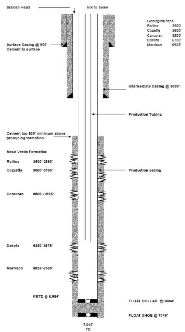
(Res. 115-07 Appx. A, 7-30-07)
Appendix B Permit Application
Appendix B
CITY OF GRAND JUNCTION WATERSHED PERMIT APPLICATION
Authority and Purpose:
In accordance with state of Colorado C.R.S. § 31-15-707(1)(b), the City of Grand Junction is authorized to restrict any activity, or require changes in the way an activity of use is performed, within a watershed which creates a substantial risk of pollution or injury to the City’s water supply or waterworks and/or the lands from under, or across or through which the water flows or is gathered. Applicants are required to comply with all guidelines and restrictions set forth in the Grand Junction Watershed Ordinance Rules and Regulations (Chapter 13.32 GJMC).
This Watershed Application Permit is designed to ensure that the City of Grand Junction watershed is sufficiently protected by all individuals conducting any activity within the watershed that may endanger the present level of water quality and quantity. All attachments, statements, and assurances provided herein by the applicant, its contractors, subcontractors, leasers, or successors will be reviewed for completion by the City of Grand Junction and the applicant will be notified regarding approval within 30 days.
SECTION 1 – Applicant Information
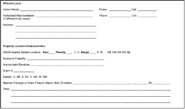
SECTION 2 – Activity Information
*Check all that apply
|
APPLICANT/ORGANIZATION |
ACTIVITY |
|||
|---|---|---|---|---|
|
Commercial/Industrial |
Road/Pad Construction |
|||
|
Oil and Gas |
Drilling |
|||
|
Mining/Mineral Exploration |
Materials/Waste Treatment, Storage, Disposal |
|||
|
Material of Interest _____________ |
Pipeline Construction |
|||
|
Utility |
Compressor Station |
|||
|
|
Land Development |
Gas Processing Facility |
||
|
Recreation |
Mine Development and Method ____________________ |
|||
|
Building Construction |
||||
|
Private Land Owner |
Septic Systems/Sewage Construction |
|||
|
|
Livestock Facility Construction |
|||
|
Government |
Timber Harvesting |
|||
|
|
Federal |
Road Construction |
||
|
|
County |
Road Maintenance |
||
|
|
Municipal |
New Facility Construction |
||
|
Facility Improvement |
||||
|
Water Supply |
Facility Maintenance |
|||
|
Water Company |
Trail Maintenance |
|||
|
Other |
Weed Control |
|||
|
|
Well Permit/Construction |
|||
|
Other: |
Surface Water Diversion |
|||
|
|
Fire Suppression/Fuels Reduction |
|||
|
Other: |
||||
|
Other: |
||||
|
Other: |
||||
SECTION 3 – Permits/Regulations Applicable to Specified Activity
|
Not Applicable |
Permit Type |
In Progress |
Completed |
|
|
Colorado Department of Public Health and Environment |
||||
|
Colorado Division of Reclamation, Mining, and Safety |
||||
|
Colorado Division of Water Resources |
||||
|
Colorado Oil and Gas Conservation Commission |
||||
|
Colorado Water Quality Control Commission |
||||
|
Mesa County |
||||
|
US Army Corps of Engineers |
||||
|
US BLM (NEPA, right-of-way, lease) |
||||
|
US Forest Service (Plan of Operations) |
SECTION 4 – Application Fee
The applicant shall be assessed a fee to cover the costs incurred by the City for reviewing and processing the application, including the costs of publication, hearing, administration, inspection and enforcement of such requested permit. The applicant shall also be assessed the costs of any legal and technical consultants retained or employed by the City for the purpose of evaluating the application’s compliance with these Watershed regulations. An initial fee deposit based on the City’s reasonable estimate of the total anticipated fees, including any consultant’s fees, shall be paid by the applicant to the City within 15 days of the fee being set by the City. Any balance of fees owed by the applicant to the City shall be paid prior to and shall be a condition for the issuance of any permit or, if no permit is issued, such balance of fees shall be payable within 15 days of billing by the City. Any unused fees shall be returned to the applicant timely in either event. (Chapter 13.32 GJMC)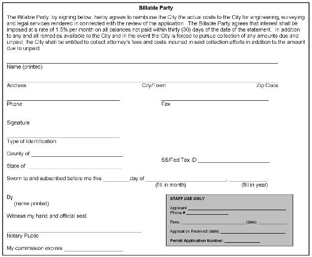
(Res. 115-07 Appx. B, 7-30-07)
Appendix C Water Quality Standards
Appendix C
Water Quality Standards for the Grand Junction Watershed Area
Lower Gunnison River Basin
Established by Colorado Water Quality Control Commission
|
• |
Segment 3 (All tributaries to the Gunnison River on national forest lands) uses: Includes portions of Brandon Ditch, Whitewater Creek and North Fork Kannah Creek located on national forest lands. |
|
|
– |
Aquatic Life Cold Class 1 |
|
|
– |
Recreation E |
|
|
– |
Water Supply |
|
|
– |
Agriculture |
|
|
– |
Ambient water quality conditions as of January 1, 2000, are not to be exceeded for any water quality standard. |
|
|
• |
Segment 4a (All tributaries to the Gunnison River not on national forest lands) uses: Includes portions of Brandon Ditch, Whitewater Creek and North Fork Kannah Creek not located on national forest lands. |
|
|
– |
Use Protected |
|
|
– |
Aquatic Life Warm Class 2 |
|
|
– |
Recreation N |
|
|
– |
Water Supply |
|
|
– |
Agriculture |
|
|
• |
Segment 4b (All lakes and reservoirs that are tributary to the Gunnison River and not on national forest lands, including all tributaries to Reeder, Hollenbeck and Juniata Reservoirs) uses: |
|
|
– |
Use Protected |
|
|
– |
Aquatic Life Warm Class 2 |
|
|
– |
Recreation E |
|
|
– |
Water Supply |
|
|
– |
Agriculture |
|
|
• |
Segment 8 (Mainstem of Kannah Creek, including all tributaries, from the boundary of national forest lands to the point of diversion for public water supply) uses: |
|
|
– |
Aquatic Life Cold Class 1 |
|
|
– |
Recreation E |
|
|
– |
Water Supply |
|
|
– |
Agriculture |
|
|
– |
Ambient water quality conditions as of January 1, 2000, are not to be exceeded for any water quality standard. |
|
|
Parameter |
Water Quality Standard |
Units |
|||||
|
Brandon Ditch (USFS lands) |
Brandon Ditch (non-USFS lands) |
North Fork Kannah Creek (USFS lands) |
North Fork Kannah Creek (non-USFS lands) |
Whitewater Creek (USFS lands) |
Whitewater Creek (non- USFS lands) |
||
|
Radionuclide Standards |
|||||||
|
Americium 241 |
0.15 |
0.15 |
0.15 |
0.15 |
0.15 |
0.15 |
Picocuries per Liter |
|
Cesium 134 |
80 |
80 |
80 |
80 |
80 |
80 |
Picocuries per Liter |
|
Plutonium 239 and 240 |
0.15 |
0.15 |
0.15 |
0.15 |
0.15 |
0.15 |
Picocuries per Liter |
|
Radium 226 and 228 |
5 |
5 |
5 |
5 |
5 |
5 |
Picocuries per Liter |
|
Strontium 90 |
8 |
8 |
8 |
8 |
8 |
8 |
Picocuries per Liter |
|
Thorium 230 and 232 |
60 |
60 |
60 |
60 |
60 |
60 |
Picocuries per Liter |
|
Tritium |
20,000 |
20,000 |
20,000 |
20,000 |
20,000 |
20,000 |
Picocuries per Liter |
|
Organic Chemicals |
|||||||
|
Acenaphthene |
420 |
420 |
420 |
420 |
420 |
420 |
Micrograms per Liter |
|
Acrolein |
3.5 |
3.5 |
3.5 |
3.5 |
3.5 |
3.5 |
Micrograms per Liter |
|
Acrylamide |
0.0078 |
0.0078 |
0.0078 |
0.0078 |
0.0078 |
0.0078 |
Micrograms per Liter |
|
Acrylonitrile |
0.065 |
0.065 |
0.065 |
0.065 |
0.065 |
0.065 |
Micrograms per Liter |
|
Alachlor |
2 |
2 |
2 |
2 |
2 |
2 |
Micrograms per Liter |
|
Aldicarb |
7 |
7 |
7 |
7 |
7 |
7 |
Micrograms per Liter |
|
Aldicarb Sulfone |
7 |
7 |
7 |
7 |
7 |
7 |
Micrograms per Liter |
|
Aldicarb Sulfoxide |
7 |
7 |
7 |
7 |
7 |
7 |
Micrograms per Liter |
|
Aldrin |
0.0021 |
0.0021 |
0.0021 |
0.0021 |
0.0021 |
0.0021 |
Micrograms per Liter |
|
Aniline |
6.1 |
6.1 |
6.1 |
6.1 |
6.1 |
6.1 |
Micrograms per Liter |
|
Anthracene (PAH) |
2,100 |
2,100 |
2,100 |
2,100 |
2,100 |
2,100 |
Micrograms per Liter |
|
Aramite |
1.4 |
1.4 |
1.4 |
1.4 |
1.4 |
1.4 |
Micrograms per Liter |
|
Atrazine |
3 |
3 |
3 |
3 |
3 |
3 |
Micrograms per Liter |
|
Azobenzene |
0.32 |
0.32 |
0.32 |
0.32 |
0.32 |
0.32 |
Micrograms per Liter |
|
Benzene |
2.3 to 5 |
2.3 to 5 |
2.3 to 5 |
2.3 to 5 |
2.3 to 5 |
2.3 to 5 |
Micrograms per Liter |
|
Benzidine |
0.00015 |
0.00015 |
0.00015 |
0.00015 |
0.00015 |
0.00015 |
Micrograms per Liter |
|
Benzo(a)anthracene (PAH) |
0.0048 |
0.0048 |
0.0048 |
0.0048 |
0.0048 |
0.0048 |
Micrograms per Liter |
|
Benzo(a)pyrene (PAH) |
0.0048 to 0.2 |
0.0048 to 0.2 |
0.0048 to 0.2 |
0.0048 to 0.2 |
0.0048 to 0.2 |
0.0048 to 0.2 |
Micrograms per Liter |
|
Benzo(b)fluoranthene (PAH) |
0.0048 |
0.0048 |
0.0048 |
0.0048 |
0.0048 |
0.0048 |
Micrograms per Liter |
|
Benzo(k)fluoranthene (PAH) |
0.0048 |
0.0048 |
0.0048 |
0.0048 |
0.0048 |
0.0048 |
Micrograms per Liter |
|
Benzo(g,h,i)perylene (PAH) |
0.0038 |
0.0038 |
0.0038 |
0.0038 |
0.0038 |
0.0038 |
Micrograms per Liter |
|
Benzotrichloride |
0.0027 |
0.0027 |
0.0027 |
0.0027 |
0.0027 |
0.0027 |
Micrograms per Liter |
|
Benzyl chloride |
0.21 |
0.21 |
0.21 |
0.21 |
0.21 |
0.21 |
Micrograms per Liter |
|
Bis(chloromethyl)ether (BCME) |
0.00016 |
0.00016 |
0.00016 |
0.00016 |
0.00016 |
0.00016 |
Micrograms per Liter |
|
Bromate |
0.050 |
0.050 |
0.050 |
0.050 |
0.050 |
0.050 |
Micrograms per Liter |
|
Bromodichloromethane (HM) |
11,000 |
11,000 |
11,000 |
11,000 |
11,000 |
11,000 |
Micrograms per Liter |
|
Bromoform (HM) |
4.3 |
4.3 |
4.3 |
4.3 |
4.3 |
4.3 |
Micrograms per Liter |
|
Butyl benzyl phthalate |
1,400 |
1,400 |
1,400 |
1,400 |
1,400 |
1,400 |
Micrograms per Liter |
|
Carbofuran |
35 to 40 |
35 to 40 |
35 to 40 |
35 to 40 |
35 to 40 |
35 to 40 |
Micrograms per Liter |
|
Carbon tetrachloride |
0.27 to 5 |
0.27 to 5 |
0.27 to 5 |
0.27 to 5 |
0.27 to 5 |
0.27 to 5 |
Micrograms per Liter |
|
Chlordane |
0.0043 |
0.0043 |
0.0043 |
0.0043 |
0.0043 |
0.0043 |
Micrograms per Liter |
|
Chlorethyl ether (BIS-2) |
0.032 |
0.032 |
0.032 |
0.032 |
0.032 |
0.032 |
Micrograms per Liter |
|
Chlorobenzene |
100 |
100 |
100 |
100 |
100 |
100 |
Micrograms per Liter |
|
Chlorodibromomethane (HM) |
54.0 |
54.0 |
54.0 |
54.0 |
54.0 |
54.0 |
Micrograms per Liter |
|
Chloroform (HM) |
3.4 |
3.4 |
3.4 |
3.4 |
3.4 |
3.4 |
Micrograms per Liter |
|
Chloroisopropyl ether(BIS-2) |
280 |
280 |
280 |
280 |
280 |
280 |
Micrograms per Liter |
|
4-Chloro-3-methylphenol |
30 |
30 |
30 |
30 |
30 |
30 |
Micrograms per Liter |
|
Chloronapthalene |
560 |
560 |
560 |
560 |
560 |
560 |
Micrograms per Liter |
|
Chlorophenol,2- |
35 |
35 |
35 |
35 |
35 |
35 |
Micrograms per Liter |
|
Chlorphrifos |
0.041 |
0.041 |
0.041 |
0.041 |
0.041 |
0.041 |
Micrograms per Liter |
|
Chrysene (PAH) |
0.0048 |
0.0048 |
0.0048 |
0.0048 |
0.0048 |
0.0048 |
Micrograms per Liter |
|
DDD |
0.15 |
0.15 |
0.15 |
0.15 |
0.15 |
0.15 |
Micrograms per Liter |
|
DDE |
0.1 |
0.1 |
0.1 |
0.1 |
0.1 |
0.1 |
Micrograms per Liter |
|
DDT |
0.001 |
0.001 |
0.001 |
0.001 |
0.001 |
0.001 |
Micrograms per Liter |
|
Dalapon |
200 |
200 |
200 |
200 |
200 |
200 |
Micrograms per Liter |
|
Demeton |
0.1 |
0.1 |
0.1 |
0.1 |
0.1 |
0.1 |
Micrograms per Liter |
|
Dibenzo(a,h)anthracene (PAH) |
0.0048 |
0.0048 |
0.0048 |
0.0048 |
0.0048 |
0.0048 |
Micrograms per Liter |
|
1,2 Dibromo-3-Chloropropane (DBCP) |
0.2 |
0.2 |
0.2 |
0.2 |
0.2 |
0.2 |
Micrograms per Liter |
|
Dichloroacetic acid |
0.7 |
0.7 |
0.7 |
0.7 |
0.7 |
0.7 |
Micrograms per Liter |
|
Dichlorobenzene 1,2 |
600 |
600 |
600 |
600 |
600 |
600 |
Micrograms per Liter |
|
Dichlorobenzene 1,3 |
94 |
94 |
94 |
94 |
94 |
94 |
Micrograms per Liter |
|
Dichlorobenzene 1,4 |
75 |
75 |
75 |
75 |
75 |
75 |
Micrograms per Liter |
|
Dichlorobenzidine |
0.078 |
0.078 |
0.078 |
0.078 |
0.078 |
0.078 |
Micrograms per Liter |
|
Dichloroethane 1,2 |
0.38 to 5 |
0.38 to 5 |
0.38 to 5 |
0.38 to 5 |
0.38 to 5 |
0.38 to 5 |
Micrograms per Liter |
|
Dichloroethylene 1,1 |
7 |
7 |
7 |
7 |
7 |
7 |
Micrograms per Liter |
|
Dichloroethylene 1,2-cis |
70 |
70 |
70 |
70 |
70 |
70 |
Micrograms per Liter |
|
Dichloroethylene 1,2-trans |
100 |
100 |
100 |
100 |
100 |
100 |
Micrograms per Liter |
|
Dichlorophenol 2,4 |
21 |
21 |
21 |
21 |
21 |
21 |
Micrograms per Liter |
|
Dichlorophenoxyacetic acid (2,4-D) |
70 |
70 |
70 |
70 |
70 |
70 |
Micrograms per Liter |
|
Dichloropropane 1,2 |
0.52 to 5 |
0.52 to 5 |
0.52 to 5 |
0.52 to 5 |
0.52 to 5 |
0.52 to 5 |
Micrograms per Liter |
|
Dichloropropylene 1,3 |
0.35 |
0.35 |
0.35 |
0.35 |
0.35 |
0.35 |
Micrograms per Liter |
|
Dichlorvos |
0.12 |
0.12 |
0.12 |
0.12 |
0.12 |
0.12 |
Micrograms per Liter |
|
Dieldrin |
0.002 |
0.002 |
0.002 |
0.002 |
0.002 |
0.002 |
Micrograms per Liter |
|
Diethyl phthalate |
5,600 |
5,600 |
5,600 |
5,600 |
5,600 |
5,600 |
Micrograms per Liter |
|
Diisopropylmethylphosphonate (DIMP) |
8 |
8 |
8 |
8 |
8 |
8 |
Micrograms per Liter |
|
Dimethylphenol 2,4 |
140 |
140 |
140 |
140 |
140 |
140 |
Micrograms per Liter |
|
Dimethyl phthalate |
70,000 |
70,000 |
70,000 |
70,000 |
70,000 |
70,000 |
Micrograms per Liter |
|
Di-n-butyl phthalate |
700 |
700 |
700 |
700 |
700 |
700 |
Micrograms per Liter |
|
Dinitrophenol 2,4 |
14 |
14 |
14 |
14 |
14 |
14 |
Micrograms per Liter |
|
Dinitro-o-cresol 4,6 |
0.27 |
0.27 |
0.27 |
0.27 |
0.27 |
0.27 |
Micrograms per Liter |
|
Dinitrotoluene 2,4 |
0.11 |
0.11 |
0.11 |
0.11 |
0.11 |
0.11 |
Micrograms per Liter |
|
Dinitrotoluene 2,6 |
230 |
230 |
230 |
230 |
230 |
230 |
Micrograms per Liter |
|
Dinoseb |
7 |
7 |
7 |
7 |
7 |
7 |
Micrograms per Liter |
|
Dioxane 1,4- |
6.1 (effective through 3/21/2010) |
6.1 (effective through 3/21/2010) |
6.1 (effective through 3/21/2010) |
6.1 (effective through 3/21/2010) |
6.1 (effective through 3/21/2010) |
6.1 (effective through 3/21/2010) |
Micrograms per Liter |
|
Dioxane 1,4- |
3.2 (effective 3/22/2010) |
3.2 (effective 3/22/2010) |
3.2 (effective 3/22/2010) |
3.2 (effective 3/22/2010) |
3.2 (effective 3/22/2010) |
3.2 (effective 3/22/2010) |
Micrograms per Liter |
|
Dioxin (2,3,7,8 TCDD) |
2.2x10⁻⁷ to 3.0x10⁻⁵ |
2.2x10⁻⁷ to 3.0x10⁻⁵ |
2.2x10⁻⁷ to 3.0x10⁻⁵ |
2.2x10⁻⁷ to 3.0x10⁻⁵ |
2.2x10⁻⁷ to 3.0x10⁻⁵ |
2.2x10⁻⁷ to 3.0x10⁻⁵ |
Micrograms per Liter |
|
Diphenylhydrazine 1,2 |
0.044 |
0.044 |
0.044 |
0.044 |
0.044 |
0.044 |
Micrograms per Liter |
|
Di(2-ethylhexyl)adipate |
400 |
400 |
400 |
400 |
400 |
400 |
Micrograms per Liter |
|
Diquat |
15 to 20 |
15 to 20 |
15 to 20 |
15 to 20 |
15 to 20 |
15 to 20 |
Micrograms per Liter |
|
Endosulfan |
0.056 |
0.056 |
0.056 |
0.056 |
0.056 |
0.056 |
Micrograms per Liter |
|
Endosulfan, alpha |
0.056 |
0.056 |
0.056 |
0.056 |
0.056 |
0.056 |
Micrograms per Liter |
|
Endosulfan, beta |
0.056 |
0.056 |
0.056 |
0.056 |
0.056 |
0.056 |
Micrograms per Liter |
|
Endosulfan sulfate |
0.056 |
0.056 |
0.056 |
0.056 |
0.056 |
0.056 |
Micrograms per Liter |
|
Endothall |
100 |
100 |
100 |
100 |
100 |
100 |
Micrograms per Liter |
|
Endrin |
0.036 |
0.036 |
0.036 |
0.036 |
0.036 |
0.036 |
Micrograms per Liter |
|
Endrin aldehyde |
2.1 |
2.1 |
2.1 |
2.1 |
2.1 |
2.1 |
Micrograms per Liter |
|
Epichlorohydrin |
3.5 |
3.5 |
3.5 |
3.5 |
3.5 |
3.5 |
Micrograms per Liter |
|
Ethylbenzene |
700 |
700 |
700 |
700 |
700 |
700 |
Micrograms per Liter |
|
Ethylene dibromide |
0.00041 to 0.05 |
0.00041 to 0.05 |
0.00041 to 0.05 |
0.00041 to 0.05 |
0.00041 to 0.05 |
0.00041 to 0.05 |
Micrograms per Liter |
|
Ethylhexyl phthalate (BIS-2) |
2.5 to 6 |
2.5 to 6 |
2.5 to 6 |
2.5 to 6 |
2.5 to 6 |
2.5 to 6 |
Micrograms per Liter |
|
Fluoranthene (PAH) |
280 |
280 |
280 |
280 |
280 |
280 |
Micrograms per Liter |
|
Fluorene (PAH) |
280 |
280 |
280 |
280 |
280 |
280 |
Micrograms per Liter |
|
Folpet |
10 |
10 |
10 |
10 |
10 |
10 |
Micrograms per Liter |
|
Furmecyclox |
1.2 |
1.2 |
1.2 |
1.2 |
1.2 |
1.2 |
Micrograms per Liter |
|
Glyphosate |
700 |
700 |
700 |
700 |
700 |
700 |
Micrograms per Liter |
|
Guthion |
0.01 |
0.01 |
0.01 |
0.01 |
0.01 |
0.01 |
Micrograms per Liter |
|
Heptachlor |
0.008 to 0.4 |
0.008 to 0.4 |
0.008 to 0.4 |
0.008 to 0.4 |
0.008 to 0.4 |
0.008 to 0.4 |
Micrograms per Liter |
|
Heptachlor epoxide |
0.0038 |
0.0038 |
0.0038 |
0.0038 |
0.0038 |
0.0038 |
Micrograms per Liter |
|
Hexachlorobenzene |
0.022 to 1.0 |
0.022 to 1.0 |
0.022 to 1.0 |
0.022 to 1.0 |
0.022 to 1.0 |
0.022 to 1.0 |
Micrograms per Liter |
|
Hexachlorobutadiene |
0.45 |
0.45 |
0.45 |
0.45 |
0.45 |
0.45 |
Micrograms per Liter |
|
Hexachlorocyclohexane, Alpha |
0.0056 |
0.0056 |
0.0056 |
0.0056 |
0.0056 |
0.0056 |
Micrograms per Liter |
|
Hexachlorocyclohexane, Beta |
0.019 |
0.019 |
0.019 |
0.019 |
0.019 |
0.019 |
Micrograms per Liter |
|
Hexachlorocyclohexane, Gamma (Lindane) |
0.08 |
0.08 |
0.08 |
0.08 |
0.08 |
0.08 |
Micrograms per Liter |
|
Hexachlorocyclohexane, Technical |
0.012 |
0.012 |
0.012 |
0.012 |
0.012 |
0.012 |
Micrograms per Liter |
|
Hexachlorocyclopentadiene (HCCPD) |
5 |
5 |
5 |
5 |
5 |
5 |
Micrograms per Liter |
|
Hexachlorodibenzo-p-dioxin (1,2,3,7,8,9-hcdd) |
5.60E-06 |
5.60E-06 |
5.60E-06 |
5.60E-06 |
5.60E-06 |
5.60E-06 |
Micrograms per Liter |
|
Hexachloroethane |
0.7 |
0.7 |
0.7 |
0.7 |
0.7 |
0.7 |
Micrograms per Liter |
|
Hydrazine/Hydrazine sulfate |
0.012 |
0.012 |
0.012 |
0.012 |
0.012 |
0.012 |
Micrograms per Liter |
|
Indeno(1,2,3-cd)pyrene (PAH) |
0.0048 |
0.0048 |
0.0048 |
0.0048 |
0.0048 |
0.0048 |
Micrograms per Liter |
|
Isophorone |
140 |
140 |
140 |
140 |
140 |
140 |
Micrograms per Liter |
|
Malathion |
0.1 |
0.1 |
0.1 |
0.1 |
0.1 |
0.1 |
Micrograms per Liter |
|
Methoxychlor |
0.03 |
0.03 |
0.03 |
0.03 |
0.03 |
0.03 |
Micrograms per Liter |
|
Methyl bromide (HM) |
9.8 |
9.8 |
9.8 |
9.8 |
9.8 |
9.8 |
Micrograms per Liter |
|
Methyl chloride (HM) |
5.6 |
5.6 |
5.6 |
5.6 |
5.6 |
5.6 |
Micrograms per Liter |
|
4,4-Methylene bis (N,N’-dimethyl)aniline |
0.76 |
0.76 |
0.76 |
0.76 |
0.76 |
0.76 |
Micrograms per Liter |
|
Methylene chloride |
4.7 to 5 |
4.7 to 5 |
4.7 to 5 |
4.7 to 5 |
4.7 to 5 |
4.7 to 5 |
Micrograms per Liter |
|
Mirex |
0.001 |
0.001 |
0.001 |
0.001 |
0.001 |
0.001 |
Micrograms per Liter |
|
Naphthalene (PAH) |
140 |
140 |
140 |
140 |
140 |
140 |
Micrograms per Liter |
|
Nitrobenzene |
3.5 |
3.5 |
3.5 |
3.5 |
3.5 |
3.5 |
Micrograms per Liter |
|
Nitrophenol 4 |
56 |
56 |
56 |
56 |
56 |
56 |
Micrograms per Liter |
|
Nitrosodibutylamine N |
0.0065 |
0.0065 |
0.0065 |
0.0065 |
0.0065 |
0.0065 |
Micrograms per Liter |
|
Nitrosodiethylamine N |
0.00023 |
0.00023 |
0.00023 |
0.00023 |
0.00023 |
0.00023 |
Micrograms per Liter |
|
Nitrosodimethylamine N |
0.00069 |
0.00069 |
0.00069 |
0.00069 |
0.00069 |
0.00069 |
Micrograms per Liter |
|
N-Nitrosodiethanolamine |
0.013 |
0.013 |
0.013 |
0.013 |
0.013 |
0.013 |
Micrograms per Liter |
|
Nitrosodiphenylamine N |
7.1 |
7.1 |
7.1 |
7.1 |
7.1 |
7.1 |
Micrograms per Liter |
|
N-Nitroso-N-methylethylamine |
0.0016 |
0.0016 |
0.0016 |
0.0016 |
0.0016 |
0.0016 |
Micrograms per Liter |
|
Nitrosopyrrolidine N |
0.017 |
0.017 |
0.017 |
0.017 |
0.017 |
0.017 |
Micrograms per Liter |
|
N-Nitrosodi-n-propylamine |
0.005 |
0.005 |
0.005 |
0.005 |
0.005 |
0.005 |
Micrograms per Liter |
|
Oxamyl (vydate) |
175 to 200 |
175 to 200 |
175 to 200 |
175 to 200 |
175 to 200 |
175 to 200 |
Micrograms per Liter |
|
PCBs |
0.0175 to 0.5 |
0.0175 to 0.5 |
0.0175 to 0.5 |
0.0175 to 0.5 |
0.0175 to 0.5 |
0.0175 to 0.5 |
Micrograms per Liter |
|
Parathion |
0.013 |
0.013 |
0.013 |
0.013 |
0.013 |
0.013 |
Micrograms per Liter |
|
Pentachlorobenzene |
5.6 |
5.6 |
5.6 |
5.6 |
5.6 |
5.6 |
Micrograms per Liter |
|
Pentachlorophenol |
0.29 to 1.0 |
0.29 to 1.0 |
0.29 to 1.0 |
0.29 to 1.0 |
0.29 to 1.0 |
0.29 to 1.0 |
Micrograms per Liter |
|
Phenol |
2,100 |
2,100 |
2,100 |
2,100 |
2,100 |
2,100 |
Micrograms per Liter |
|
Picloram |
490 |
490 |
490 |
490 |
490 |
490 |
Micrograms per Liter |
|
Propylene oxide |
0.15 |
0.15 |
0.15 |
0.15 |
0.15 |
0.15 |
Micrograms per Liter |
|
Pyrene (PAH) |
210 |
210 |
210 |
210 |
210 |
210 |
Micrograms per Liter |
|
Quinoline |
0.012 |
0.012 |
0.012 |
0.012 |
0.012 |
0.012 |
Micrograms per Liter |
|
Simazine |
4 |
4 |
4 |
4 |
4 |
4 |
Micrograms per Liter |
|
Styrene |
100 |
100 |
100 |
100 |
100 |
100 |
Micrograms per Liter |
|
Tetrachlorobenzene 1,2,4,5- |
2.1 |
2.1 |
2.1 |
2.1 |
2.1 |
2.1 |
Micrograms per Liter |
|
Tetrachloroethane 1,1,2,2 |
0.18 |
0.18 |
0.18 |
0.18 |
0.18 |
0.18 |
Micrograms per Liter |
|
Tetrachloroethylene (PCE) |
5 |
5 |
5 |
5 |
5 |
5 |
Micrograms per Liter |
|
Toluene |
1,000 |
1,000 |
1,000 |
1,000 |
1,000 |
1,000 |
Micrograms per Liter |
|
Toxaphene |
0.0002 |
0.0002 |
0.0002 |
0.0002 |
0.0002 |
0.0002 |
Micrograms per Liter |
|
Tributyltin (TBT) |
0.072 |
0.072 |
0.072 |
0.072 |
0.072 |
0.072 |
Micrograms per Liter |
|
Trichlorobenzene 1,2,4- |
50 |
50 |
50 |
50 |
50 |
50 |
Micrograms per Liter |
|
Trichloroethane 1,1,1 (1,1,1-TCA) |
200 |
200 |
200 |
200 |
200 |
200 |
Micrograms per Liter |
|
Trichloroethane 1,1,2 (1,1,2-TCA) |
2.8 to 5 |
2.8 to 5 |
2.8 to 5 |
2.8 to 5 |
2.8 to 5 |
2.8 to 5 |
Micrograms per Liter |
|
Trichloroethylene (TCE) |
5 |
5 |
5 |
5 |
5 |
5 |
Micrograms per Liter |
|
Trichlorophenol 2,4,5 |
700 |
700 |
700 |
700 |
700 |
700 |
Micrograms per Liter |
|
Trichlorophenol 2,4,6 |
3.2 |
3.2 |
3.2 |
3.2 |
3.2 |
3.2 |
Micrograms per Liter |
|
Trichlorophenoxypropionic acid (2,4,5-tp) |
50 |
50 |
50 |
50 |
50 |
50 |
Micrograms per Liter |
|
Trihalomethanes |
80 |
80 |
80 |
80 |
80 |
80 |
Micrograms per Liter |
|
Vinyl Chloride |
0.023 to 2 |
0.023 to 2 |
0.023 to 2 |
0.023 to 2 |
0.023 to 2 |
0.023 to 2 |
Micrograms per Liter |
|
Xylenes (total) |
1,400 to 10,000 |
1,400 to 10,000 |
1,400 to 10,000 |
1,400 to 10,000 |
1,400 to 10,000 |
1,400 to 10,000 |
Micrograms per Liter |
|
Physical Standards |
|||||||
|
Dissolved Oxygen |
6.0, 7.0 (spawning) |
5.0 |
6.0, 7.0 (spawning) |
5.0 |
6.0, 7.0 (spawning) |
5.0 |
Milligrams per Liter |
|
pH |
6.5 – 9.0 |
6.5 – 9.0 |
6.5 – 9.0 |
6.5 – 9.0 |
6.5 – 9.0 |
6.5 – 9.0 |
Standards Units |
|
Temperature |
Max 20° with 3° increase |
None |
Max 20° with 3° increase |
None |
Max 20° with 3° increase |
None |
Degrees Celsius |
|
Biological Standards |
|||||||
|
E. coli |
126 |
630 |
126 |
630 |
126 |
630 |
Per 100 mL |
|
Inorganic Standards |
|||||||
|
Ammonia, Total |
3.91 |
0.75 |
3.69 |
0.68 |
3.91 |
0.90 |
Milligrams per Liter as N |
|
Total Residual Chlorine |
0.011 |
0.011 |
0.011 |
0.011 |
0.011 |
0.011 |
Milligrams per Liter |
|
Cyanide – Free |
0.005 |
0.005 |
0.005 |
0.005 |
0.005 |
0.005 |
Milligrams per Liter |
|
Fluoride |
2.0 |
2.0 |
2.0 |
2.0 |
2.0 |
2.0 |
Milligrams per Liter |
|
Nitrate |
10 |
10 |
10 |
10 |
10 |
10 |
Milligrams per Liter as N |
|
Nitrite |
0.06 |
0.06 |
0.06 |
0.06 |
0.06 |
0.14 |
Milligrams per Liter as N |
|
Sulfide |
0.002 undissociated |
0.002 undissociated |
0.002 undissociated |
0.002 undissociated |
0.002 undissociated |
0.002 undissociated |
Milligrams per Liter as H2S |
|
Boron |
0.75 |
0.75 |
0.75 |
0.75 |
0.75 |
0.75 |
Milligrams per Liter |
|
Chloride |
250 |
250 |
250 |
250 |
250 |
250 |
Milligrams per Liter |
|
Sulfate |
250 |
250 |
250 |
250 |
250 |
250 |
Milligrams per Liter |
|
Asbestos |
7,000,000 |
7,000,000 |
7,000,000 |
7,000,000 |
7,000,000 |
7,000,000 |
Fibers per Liter |
|
Metals Standards |
|||||||
|
Aluminum |
750 |
750 |
750 |
750 |
750 |
750 |
Micrograms per Liter |
|
Antimony |
6.0 |
6.0 |
6.0 |
6.0 |
6.0 |
6.0 |
Micrograms per Liter |
|
Arsenic |
0.02 – 10 |
0.02 – 10 |
0.02 – 10 |
0.02 – 10 |
0.02 – 10 |
0.02 – 10 |
Micrograms per Liter |
|
Barium |
490 |
490 |
490 |
490 |
490 |
490 |
Micrograms per Liter |
|
Beryllium |
4.0 |
4.0 |
4.0 |
4.0 |
4.0 |
4.0 |
Micrograms per Liter |
|
Cadmium |
0.15 |
0.25 |
0.15 |
0.34 |
0.15 |
0.58 |
Micrograms per Liter |
|
Chromium III |
24 |
42 |
24 |
50 |
24 |
50 |
Micrograms per Liter |
|
Chromium VI |
11 |
11 |
11 |
11 |
11 |
11 |
Micrograms per Liter |
|
Copper |
2.7 |
5.0 |
2.7 |
7.0 |
2.7 |
13 |
Micrograms per Liter |
|
Iron |
300 |
300 |
300 |
300 |
300 |
300 |
Micrograms per Liter |
|
Lead |
0.5 |
1.2 |
0.5 |
1.8 |
0.5 |
3.9 |
Micrograms per Liter |
|
Manganese |
50 |
50 |
50 |
50 |
50 |
50 |
Micrograms per Liter |
|
Mercury |
1.4 |
1.4 |
1.4 |
1.4 |
1.4 |
1.4 |
Micrograms per Liter |
|
Nickel |
16 |
29 |
16 |
41 |
16 |
72 |
Micrograms per Liter |
|
Selenium |
4.6 |
4.6 |
4.6 |
4.6 |
4.6 |
4.6 |
Micrograms per Liter |
|
Silver |
0.01 |
0.02 |
0.01 |
0.05 |
0.01 |
0.15 |
Micrograms per Liter |
|
Thallium |
0.24 |
0.24 |
0.24 |
0.24 |
0.24 |
0.24 |
Micrograms per Liter |
|
Uranium |
30 |
30 |
30 |
30 |
30 |
30 |
Micrograms per Liter |
|
Zinc |
38 |
69 |
38 |
97 |
38 |
176 |
Micrograms per Liter |
(Res. 115-07 Appx. C, 7-30-07)
Appendix D Watershed Map
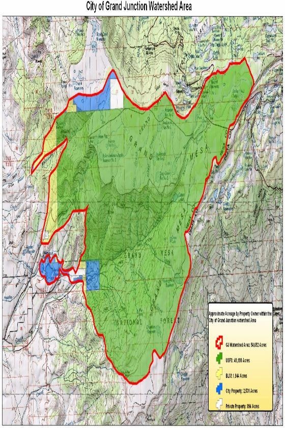
(Res. 115-07 Appx. D, 7-30-07)