


Chapter 28.12
DRAINAGE PLANNING SUBMITTAL REQUIREMENTS
Sections:
28.12.020 Submittal requirements.
28.12.030 Conceptual/preliminary drainage report.
28.12.040 Conceptual/preliminary report contents.
28.12.050 Conceptual/preliminary report drawing contents.
28.12.060 Final drainage report.
28.12.070 Final report contents.
28.12.080 Final report drawing contents.
28.12.100 Post-construction BMPs.
28.12.120 Record drawings and acceptances.
28.12.130 Submittal checklist.
28.12.010 Review process.
All development within the jurisdiction of this manual shall submit drainage reports, construction drawings/specifications, and record drawing information for review and approval in accordance with the requirements of this chapter. The City of Fruita, the Town of Palisade, or the Grand Junction Drainage District may alter the requirements of this chapter, in accordance with their guidance documents. Figure 28.12.010 provides a flow chart of the general review process.
(a) Mesa County. The County will review reports and plans for completeness of the submittal to the Planning Department. The County will provide written or oral review comments of the submittal. The County will make every effort to effect a complete review and comment within a reasonable period; however, the County cannot approve reports or plans by default.
The applicant or his designated representative is required to attend a pre-application conference to review processing steps in accordance with the Mesa County Land Development Code (Code Section 3.1.6). The applicant shall consult with the Director or representative for general information regarding land development regulations, required procedures, possible drainage problems and deviations/variances, and specific submittal requirements. As a minimum, a conceptual and final drainage report will be required, unless modified at the pre-application conference.
(b) City of Grand Junction. The City shall review and approve drainage reports and construction plans in accordance with Submittal Standards for Improvements and Development (SSID), Zoning and Development Code (GJMC Title 21), and the pollution prevention stormwater ordinance.
(c) Other Jurisdictions. Refer to requirements of the City of Fruita, the Town of Palisade or the Grand Junction Drainage District for specific information regarding review and acceptance of drainage reports and plans.
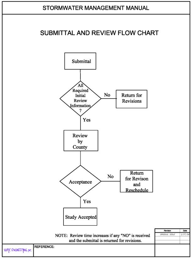
FIGURE 28.12.010
(Res. 40-08 (§ 300), 3-19-08)
28.12.020 Submittal requirements.
A conceptual/preliminary and final drainage report is required for all new development and redevelopment, except as otherwise determined at the pre-application conference. The number of report copies to be submitted will be determined at the pre-application conference. One copy will be returned to the applicant or his representative with comments.
All submitted reports shall be clearly and cleanly reproduced. Copies of charts, tables, nomographs, calculations, or any other referenced material shall be legible. Washed out, blurred or unreadable portions of the report are unacceptable and may warrant resubmittal of the report. The submittal shall include a declaration of the type of report submitted (i.e., conceptual/preliminary or final).
Table 28.12.020 shall be used to determine the adequacy of the submittal, in addition to those requirements identified at the pre-application meeting, which may alter the checklist. Incomplete or absent information may result in the report being rejected for review. Revision dates must be included on all re-submittals.
All development and redevelopment must provide construction site best management practices (see Chapter 28.60 GJMC), on-site detention (see Chapter 28.56 GJMC), and post-construction BMPs (see Chapter 28.64 GJMC), unless otherwise modified at the pre-application conference.
|
Instructions: |
1. |
Applicant to identify with a check-mark if information is provided with report. If applicant believes information is not required, indicate with “n/a” and attach separate sheet with explanation. |
|||
|
|
|
|
2. |
The reviewer will determine if information labeled “n/a” is required and whether information must be submitted. |
|
|
|
|
|
3. |
Those items noted with an asterisk are not typically required for conceptual/preliminary report. Applicant shall confirm this with local jurisdiction. |
|
|
|
|
|
4. |
Submit three copies of report and include copy of check list bound with report. |
|
|
|
|
TITLE PAGE |
|||
|
|
|
A. |
Type of report (conceptual/preliminary or final drainage report). |
||
|
|
|
B. |
Project name. |
||
|
|
|
C. |
Preparer name, firm, address, number, and date. |
||
|
|
|
D. |
Professional Engineer’s seal of preparer. |
||
|
|
|
E. |
Certifications (see GJMC 28.12.070). |
||
|
|
I. |
INTRODUCTION |
|||
|
|
|
A. |
Background |
||
|
_________ |
|
|
1. |
Identify report preparer and purpose. |
|
|
_________ |
|
|
2. |
Identify date of letter with previous County comments. |
|
|
|
|
B. |
Project Location |
||
|
_________ |
|
|
1. |
Identify Township, Range, and Section. |
|
|
_________ |
|
|
2. |
Identify adjacent street and subdivision names. |
|
|
_________ |
|
|
3. |
Reference to General Location Map. |
|
|
|
|
C. |
Property Description |
||
|
_________ |
|
|
1. |
Identify area in acres of entire contiguous ownership. |
|
|
_________ |
|
|
2. |
Describe existing ground cover, vegetation, soils, topography and slopes. |
|
|
_________ |
|
|
3. |
Describe existing drainage facilities, such as channels, detention areas, or structures. |
|
|
_________ |
|
|
4. |
Describe existing irrigation facilities, such as ditches, headgates, or diversions. |
|
|
_________ |
|
|
5. |
Identify proposed types of land use and encumbrances. |
|
|
|
|
D. |
Previous Investigations |
||
|
_________ |
|
|
1. |
Identify drainage master plans that include the project area, including floodplain studies. |
|
|
_________ |
|
|
2. |
Identify drainage reports for adjacent development. |
|
|
|
II. |
DRAINAGE SYSTEM DESCRIPTION |
|||
|
|
|
A. |
Existing Drainage Conditions |
||
|
_________ |
|
|
1. |
Describe existing topography and provide map with contours extending a minimum of 100 feet beyond property limits. |
|
|
_________ |
|
|
2. |
Identify major drainageway or outfall drainageway and describe map showing location of proposed development within the drainageways. |
|
|
_________ |
|
|
3. |
Identify pre-developed drainage patterns and describe map showing predeveloped sub-basins and concentrated discharge locations. Provide calculations of pre-developed peak flows entering and leaving the site. |
|
|
|
|
B. |
Master Drainage Plan |
||
|
_________ |
|
|
1. |
Describe location of the project relative to a previously prepared master drainage plan, including drainage plans prepared for adjacent development. |
|
|
|
|
C. |
Off-Site Tributary Area |
||
|
_________ |
|
|
1. |
Identify all off-site drainage basins that are tributary to the project. |
|
|
_________ |
|
|
2. |
Identify assumptions regarding existing and future land use and effects of off-site detention on peak flows. |
|
|
|
|
D. |
Proposed Drainage System Description |
||
|
_________ |
|
|
1. |
Identify how off-site stormwater is collected and conveyed through the site and ultimately to the receiving water(s). |
|
|
_________ |
|
|
2. |
Identify sub-basins and describe, in general terms, how on-site stormwater is collected and conveyed through the site for each location where stormwater is discharged from the site. |
|
|
_________* |
|
|
3. |
Describe detention volumes, release rates and pool elevations. |
|
|
_________* |
|
|
4. |
Identify the difference in elevation between pond invert and the groundwater table. |
|
|
_________ |
|
|
5. |
Describe how stormwater is discharged from the site, including both concentrated and dispersed discharges and rates. |
|
|
_________ |
|
|
6. |
Describe stormwater quality facilities. |
|
|
_________* |
|
|
7. |
Describe maintenance access aspects of design. |
|
|
_________* |
|
|
8. |
Describe easements and tracts for drainage purposes, including limitation on use. |
|
|
|
|
E. |
Drainage Facility Maintenance |
||
|
_________* |
|
|
1. |
Identify responsible parties for maintenance of each drainage and water quality facility. |
|
|
_________* |
|
|
2. |
Identify general maintenance activities and schedules. |
|
|
|
III. |
DRAINAGE ANALYSIS AND DESIGN CRITERIA |
|||
|
|
|
A. |
Regulations |
||
|
_________ |
|
|
1. |
Identify that analysis and design was prepared in accordance with the provisions of this manual. |
|
|
_________ |
|
|
2. |
Identify other regulations or criteria which have been used to prepare analysis and design. |
|
|
|
|
B. |
Development Criteria |
||
|
_________ |
|
|
1. |
Identify drainage constraints placed on the project, such as by a major drainage study, floodplain study or other drainage reports relevant to the project. |
|
|
_________ |
|
|
2. |
Identify drainage constraints placed on the project, such as from major street alignments, utilities, existing structures, and other developments. |
|
|
|
|
C. |
Hydrologic Criteria |
||
|
|
|
|
|
(If manual was followed without deviation, then a statement to that effect is all that is required. Otherwise provide the following information where the criteria used deviates from this manual.) |
|
|
_________ |
|
|
1. |
Identify developed storm runoff peak flows and volumes and how they were determined, including rainfall intensity or design storm. |
|
|
_________ |
|
|
2. |
Identify which storm events were used for minor and major flood analysis and design. |
|
|
_________ |
|
|
3. |
Identify how and why any other deviations from this manual occurred. |
|
|
|
|
D. |
Hydraulic Criteria |
||
|
|
|
|
|
(If manual was followed without deviation, then a statement to that effect is all that is required. Otherwise provide the following information where the criteria used deviates from this manual.) |
|
|
_________* |
|
|
1. |
Identify type(s) of streets within and adjacent to development and source for allowable street capacity. |
|
|
_________* |
|
|
2. |
Identify which type(s) of storm inlets were analyzed or designed and source for allowable capacity. |
|
|
_________* |
|
|
3. |
Identify which type of storm sewers which were analyzed or designed and Manning’s n-values used. |
|
|
_________* |
|
|
4. |
Identify which method was used to determine detention volume requirements and how allowable release rates were determined. |
|
|
_________* |
|
|
5. |
Identify how the capacity of open channels and culverts were determined. |
|
|
_________* |
|
|
6. |
Identify any special analysis or design requirements not contained with this manual. |
|
|
_________ |
|
|
7. |
Identify how and why any other deviations from this manual occurred. |
|
|
|
|
E. |
Variance from Criteria |
||
|
_________ |
|
|
1. |
Identify any provisions of this manual for which a variance is requested. |
|
|
_________ |
|
|
2. |
Identify pre-existing conditions which cause the variance request. |
|
|
|
*IV. |
POST-CONSTRUCTION STORMWATER MANAGEMENT. See Chapter 28.64 GJMC for requirements. |
|||
|
|
Note: |
This section of the final drainage report identifies additional information required by Mesa County’s, City of Grand Junction’s, and Town of Palisade’s, permit for stormwater discharges associated with municipal separate storm sewer systems (MS4s), Permit No. COR-090000. The final drainage plan and the construction SWMP (see Chapter 28.60 GJMC) meets the requirements of the MS4s permit. In general, this section identifies permanent BMP practices to control the discharge of pollutants after construction is complete. |
|||
|
|
|
*A. |
Stormwater Quality Control Measures |
||
|
_________* |
|
|
1. |
Describe the post-construction BMPs to control discharge of pollutants from the project site. |
|
|
_________* |
|
|
2. |
If compensating detention is provided, discuss practices to address water quality from area not tributary to detention area. |
|
|
_________* |
|
|
3. |
If underground detention is proposed, discuss how water quality facilities will be provided on the surface. |
|
|
_________ |
|
|
4. |
If proprietary BMPs are proposed, provide the justification and sizing requirements (see GJMC 28.64.040). |
|
|
|
|
*B. |
Calculations |
||
|
_________ |
|
|
1. |
Provide methods and calculations for WQCV, sediment storage, and water quality outlet structure. |
|
|
|
V. |
CONCLUSIONS |
|||
|
|
|
A. |
Compliance with Manual |
||
|
_________ |
|
|
|
Compliance with manual and other approved documents, such as drainage plans and floodplain studies. |
|
|
|
|
B. |
Design Effectiveness |
||
|
_________ |
|
|
|
Effectiveness of drainage design to control impacts of storm runoff. |
|
|
|
|
C. |
Areas in Flood Hazard Zone |
||
|
_________ |
|
|
|
Meet requirements of Floodplain Regulations: Mesa County Land Development Code, Section 7.13; GJMC 21.07.010. |
|
|
|
|
D. |
Variances from Manual |
||
|
_________ |
|
|
|
Applicant shall identify any requested variances and provide basis for approving variance. If no variances are requested, applicant shall state that none are requested. |
|
|
|
VI. |
REFERENCES |
|||
|
_________ |
|
|
Provide a reference list of all criteria, master plans, drainage reports, and technical information used. |
||
|
|
|
TABLES |
|||
|
_________ |
|
|
Include copy of all tables prepared for report. |
||
|
|
|
FIGURES |
|||
|
_________ |
|
A. |
|
|
General Location Map (See GJMC 28.12.080(a)) |
|
_________ |
|
B. |
|
|
Floodplain Information |
|
_________ |
|
C. |
|
|
Drainage Plan (See GJMC 28.12.080(b)) |
|
_________ |
|
D. |
|
|
Other pertinent figures. |
|
|
|
APPENDICES |
|||
|
|
|
A. |
DESIGN CHARTS |
||
|
_________ |
|
|
1. |
Provide copy of all design charts (i.e., tables, figures, charts from other criteria) used for the report. |
|
|
|
|
B. |
HYDROLOGIC CALCULATIONS (see Chapters 28.24 and 28.28 GJMC) |
||
|
_________ |
|
|
1. |
Land use assumptions for off-site runoff calculations. |
|
|
_________ |
|
|
2. |
Time of concentration and runoff coefficients for pre-existing and post development conditions. |
|
|
_________ |
|
|
3. |
Pre-developed hydrologic computations. |
|
|
_________ |
|
|
4. |
Developed conditions hydrologic computations. |
|
|
|
|
C. |
HYDRAULIC CALCULATIONS |
||
|
_________ |
|
|
1. |
Capacity of existing channels, streets, storm sewers, inlets, culverts and other facilities. |
|
|
_________ |
|
|
2. |
Calculations for existing storm sewer and open channel. |
|
|
_________ |
|
|
3. |
Irrigation ditch flows and ditch system capacity. |
|
|
_________* |
|
|
4. |
Detention pond design (see Chapter 28.56 GJMC for requirements). |
|
|
_________* |
|
|
|
a. |
Storage volume, release rates, and pool elevations for 10-year and 100-year storm. |
|
_________* |
|
|
|
b. |
Outlet structure dimensions, orifice diameter, weir lengths, pipe headwater and other data. |
|
_________* |
|
|
|
c. |
Outlet velocity and energy dissipation requirements. |
|
_________* |
|
|
|
d. |
Routing of outlet flows and emergency spillway flows. |
|
_________* |
|
|
5. |
Street capacity calculations, if data in manual not used (see Chapter 28.44 GJMC). |
|
|
_________* |
|
|
6. |
Storm inlet capacity calculations, if data in manual not used (see Chapter 28.44 GJMC). |
|
|
_________* |
|
|
7. |
Storm sewer capacity calculations, if data in manual not used (see Chapter 28.44 GJMC). |
|
|
_________* |
|
|
8. |
Channel capacity calculations, if data in manual not used (see Chapter 28.32 GJMC). |
|
|
_________* |
|
|
9. |
Culvert capacity calculations (see Chapter 28.48 GJMC). |
|
|
_________* |
|
|
10. |
Other hydraulic structure calculations (see Chapter 28.36 GJMC). |
|
|
|
|
D. |
STORMWATER QUALITY CALCULATIONS |
||
|
_________ |
|
|
1. |
|
Water quality capture volume (WQCV). |
|
_________* |
|
|
2. |
|
Storage volume for sediment volume and pool elevations for WQCV. |
|
_________* |
|
|
3. |
|
Outlet calculations for required area per row, diameter of individual holes, number of holes per row, and number of holes per column. |
|
_________ |
CERTIFICATION – PROFESSIONAL ENGINEER’S SEAL AND SIGNATURE |
||||
|
|
ACKNOWLEDGEMENTS |
||||
|
|
|
Drainage Report checklist was prepared by: ___________________________ |
|||
(Res. 40-08 (§ 301), 3-19-08)
28.12.030 Conceptual/preliminary drainage report.
The purpose of the conceptual/preliminary drainage report is to:
(a) Identify drainage conditions prior to proposed development, including designated floodplain boundaries (see Table 28.12.020).
(b) Identify existing and potential drainage problems, which may occur on site or off site because of the development.
(c) Identify proposed solutions to drainage problems, including location of detention storage and water quality requirements, in sufficient detail to verify technical feasibility.
Text shall be typed on eight-and-one-half-inch by 11-inch paper. All pages, including appendices, shall be numbered in a fashion that identifies the report (e.g., PDR-#). Text, tables, figures, charts, calculations, and appendices shall be bound to form a formal report. Drawings shall be included in a pocket attached with the report, but shall not be smaller than 11 inches by 17 inches or larger than 24 inches by 36 inches in size. The report shall include a cover letter presenting the conceptual/preliminary design for review and shall be stamped and signed by an engineer licensed in Colorado.
(Res. 40-08 (§ 302), 3-19-08)
28.12.040 Conceptual/preliminary report contents.
The conceptual/preliminary drainage report shall contain general information regarding the proposed drainage facilities for the development. For instance, only identify that a channel or storm drain is proposed for conveyance, and not the size, slope, velocity or other more detailed information. Also, it is only required to identify the location and type of detention (i.e., drainage and water quality), and not the volumes or release rates; however, post-development flow rates shall be calculated and submitted with the preliminary report.
The report shall be prepared in accordance with the outline provided as part of the checklist in Table 28.12.020 (see also GJMC 28.12.130). Grading and erosion control information are not required. The checklist must be completed by the applicant and included with the drainage report. The checklist will be used to determine the completeness of the report. If information provided is lacking or incomplete, the information may be required prior to further review. It is understood that information in the conceptual/preliminary drainage report is subject to change. More detail can be required if necessary due to the complexity of a development.
(Res. 40-08 (§ 302.1), 3-19-08)
28.12.050 Conceptual/preliminary report drawing contents.
(a) General Location Map. A map (eight and one-half inches by 11 inches) shall be provided in sufficient detail at a scale not larger than one inch equals 1,000 feet and included with the report. The map shall identify:
(1) Drainage flows entering and leaving the development and general drainage patterns within the development.
(2) Path of all drainage from the upper end of any off-site basins to the defined major drainageways (see Chapter 28.16 GJMC, Drainage Policy).
(3) Major construction (i.e., development, irrigation ditches, existing detention facilities, culverts, and storm drains) along the entire path of drainage.
(4) All major basins. Topographic contours are optional.
(b) Conceptual/Preliminary Drainage Plan. Map(s) of the proposed development at a scale of one inch equals 20 feet to one inch equals 200 feet on a 24-inch by 36-inch drawing shall be included. The plan shall show the following:
(1) Existing and (if available) proposed contours at five-foot maximum intervals. The contours shall extend beyond the property boundaries the distance necessary to show how the development interacts hydraulically with the surrounding area, but no less than 50 feet. Mesa County contours are acceptable provided they are representative of actual field conditions.
(2) All existing drainage facilities. If existing (pre-development) conditions cannot be adequately addressed on the proposed drainage plan, then a separate existing conditions drainage plan shall be prepared and included with the submittal document.
(3) Approximate flooding limits based on available information.
(4) Conceptual major drainage facilities including detention basins, storm drains, swales, riprap, and outlet structures in the detail consistent with the proposed development plan.
(5) Major drainage boundaries and sub-boundaries.
(6) Any off-site feature influencing development, including both upstream and downstream structures.
(7) Proposed flow directions entering, within, and exiting the development and, if available, proposed contours. Identify the drainage path from the development to the nearest MS4 facility or major drainageway.
(8) Existing and proposed irrigation facilities.
(9) Legend to define map symbols.
(10) Title block in lower right corner.
(11) All elevations shall be NAVD 1988.
(Res. 40-08 (§ 302.2), 3-19-08)
28.12.060 Final drainage report.
The purpose of the final drainage report is to:
(a) Identify drainage conditions prior to proposed development, including floodplain boundaries.
(b) Identify existing and potential drainage problems, which may occur on site or off site because of the development.
(c) Investigate or refine conceptual solutions to drainage problems, including detention storage and water quality requirements, in sufficient detail to verify their technical feasibility.
(d) Present final design and details for drainage facilities discussed in the conceptual/preliminary drainage report.
(e) Identify post-construction BMPs to control the discharge of pollutants in stormwater to the maximum extent practicable.
Text shall be typed on eight-and-one-half-inch by 11-inch paper. All pages, including appendices, shall be numbered in a fashion that identifies the report (e.g., FDR-#). Text, tables, figures, charts, calculations, and appendices shall be bound to form a formal report. Drawings shall be 24 inches by 36 inches and included in a pocket attached with the report. The report shall include a cover letter presenting final design for review and shall be stamped and signed by an engineer licensed in Colorado.
(Res. 40-08 (§ 303), 3-19-08)
28.12.070 Final report contents.
The final drainage report shall provide final details of proposed drainage facilities, including grading, erosion control, and water quality enhancement, and is to be submitted along with construction documents (see GJMC 28.12.130).
The final drainage report shall be prepared by an engineer registered in Colorado in accordance with the outline provided as part of the checklist in Table 28.12.020 (see also GJMC 28.12.130). The checklist must be completed by the applicant and included with the drainage report. The checklist will be used to determine the completeness of the report. If information provided is lacking or incomplete, the information may be required prior to further review.
The report shall contain the following certifications:
I hereby certify that this Final Drainage Report (plan) for the design of (Name of Development) was prepared by me (or under my direct supervision) in accordance with the provisions of the Stormwater Management Manual for the owners thereof. I understand that the (local jurisdiction) does not and will not assume liability for drainage facilities designed by others.
__________________________
Registered Professional Engineer
State of Colorado No._________
(Affix Seal)
I, (Name of Developer) hereby certify that the drainage facilities for (Name of Development) shall be constructed according to the design presented in this report. I understand that the (local jurisdiction) does not and will not assume liability for the drainage facilities designed and/or certified by my engineer. I understand that the (local jurisdiction) reviews drainage plans but cannot, on behalf of (Name of Development), guarantee that final drainage design review will absolve (Name of Developer) and/or their successors and/or assigns of future liability for improper design. I further understand that approval of the Final Plat and/or Final Development Plan does not imply approval of my engineer’s drainage design.
_______________________
Name of Developer
______________________ ___________________
Authorized Signature Date
(Res. 40-08 (§ 303.1), 3-19-08)
28.12.080 Final report drawing contents.
(a) General Location Map. An eight-and-one-half-inch by 11-inch map shall be provided in sufficient detail at a scale not larger than one inch equals 1,000 feet and included with the report. The map shall identify:
(1) Drainage flows entering and leaving the development and general drainage patterns.
(2) Path of all drainage from the upper end of any off-site basins to the defined major drainageways (see Chapter 28.16 GJMC, Drainage Policy).
(3) Major construction (i.e., development, irrigation ditches, existing detention facilities, culverts, and storm drains) along the entire path of drainage.
(4) All major basins. Topographic contours are optional.
(b) Final Drainage Plan. Map(s) of the proposed development at a scale of one inch equals 20 feet to one inch equals 200 feet on a 24-inch by 36-inch drawing shall be included. The plan shall show the following:
(1) Existing and proposed contours at two-foot maximum intervals. The contours shall be based on a USGS datum and extend a minimum of 50 feet beyond property lines, or further if required to show how the development interacts with the surrounding area.
(2) Location of benchmarks, which must be one of the following:
(i) Mesa County monumentation, including GIS reference points;
(ii) USGS NAVD 1988;
(iii) City of Grand Junction; or
(iv) Colorado Department of Transportation.
(3) Property lines and easements with purposes noted.
(4) Existing street names and proposed streets, indicating names, right-of-way width, flowline width, curb type, sidewalk, and approximate slopes.
(5) All existing drainage boundaries and peak flows entering and within the exiting development. Existing facilities such as irrigation and roadside ditches, drainageways, culverts, and detention sites. Include pertinent characteristics, such as location, size, shape, slope, and material. A separate existing conditions drainage plan shall be prepared and included with the submittal document that details the pre-development conditions listed in this line item.
(6) Any off-site feature influencing development, including both upstream and downstream structures.
(7) Proposed drainage boundaries and sub-boundaries.
(8) Proposed type of street flow (i.e., vertical or combination curb and gutter), roadside ditches, gutter slope, and flow directions, and cross-pans.
(9) Proposed storm drains and open drainageways, including inlets, manholes, culverts, and other appurtenances, including erosion/riprap protection.
(10) Proposed outfall point for runoff from the developed area and facilities to convey flows to the final outfall point without damage to downstream properties.
(11) Routing and accumulation and flows at various critical points for the initial storm runoff listed on the drawing.
(12) Volumes and release rates for detention storage facilities and information on outlet works.
(13) Location and elevations of all existing floodplains affecting the property.
(14) Location and elevations of all existing and proposed utilities affected by or affecting the drainage design.
(15) Routing of off-site drainage flow through the development.
(16) Definition of flow path leaving the development through the downstream properties ending at a major drainageway.
(17) Legend to define map symbols (see Table 28.12.080 for symbol criteria).
(18) Title block in lower right hand corner.
(19) Identify each post-construction BMP including the WQCV provided or other bases for sizing BMPs.
(20) All elevations shall be NAVD 1988.
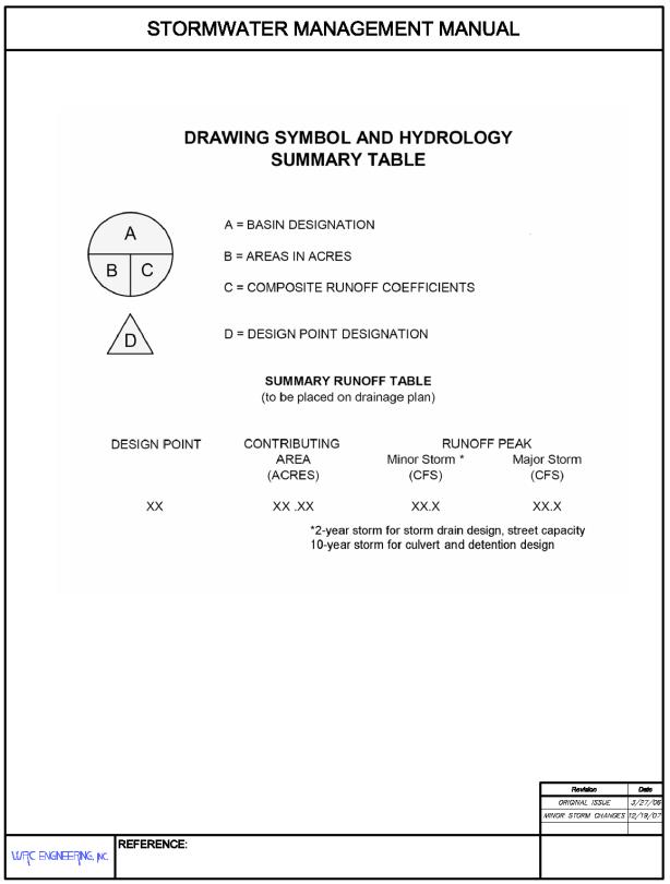
TABLE 28.12.080
(Res. 40-08 (§ 303.2), 3-19-08)
28.12.090 Construction plans.
(a) Mesa County. The final construction plans and final drainage report must be submitted for acceptance to the Director at least 20 working days prior to the consideration of the plat before the County Commissioners. Before final subdivision plats and site plans can be submitted to County Commissioners for approval, the following conditions must be met:
(1) Drainage reports and/or construction plans must be accepted by the Director without conditions;
(2) All required easements and licenses with the County must be approved by the Director and the County Attorney, and the appropriate title insurance provided; and
(3) Easements and other agency approvals must be fully executed and copies provided to the County.
Acceptance of the final construction plans and final drainage report are required prior to issuance of a permit.
Construction plans shall be prepared in accordance with sound engineering principles, this manual and the Mesa County Land Development Code for subdivision designs. Construction documents shall include geometric, dimensional, structural, foundation, bedding, hydraulic, landscaping, and other details as needed to construct the storm drainage facility. The approved final drainage plan shall be included as part of the construction document for all facilities affected by the drainage plan. Construction plans shall be signed by a registered professional engineer as being in accordance with the County approved drainage report, drawings, and this manual. Requirements for construction plans are outlined in the checklist in Table 28.12.090.
(b) City of Grand Junction. Refer to the Submittal Standards for Improvements and Development for specific requirements for construction plans.
(c) Other Jurisdictions. Refer to requirements of the City of Fruita, Town of Palisade or the Grand Junction Drainage District for construction plans.
|
Instructions: |
1. |
Applicant to identify with a check-mark if information is provided. If applicant believes information is not required, indicate with “n/a.” |
||
|
|
|
2. |
County will determine if information labeled “n/a” is required and whether information must be submitted. |
|
|
|
I. |
EXISTING FACILITIES |
||
|
_________ |
|
A. |
Contours at two-foot intervals, based on USGS datum. Contours to extend at least 50 feet past property line. |
|
|
_________ |
|
B. |
Location and elevation of USGS benchmarks or benchmarks referenced to USGS. |
|
|
_________ |
|
C. |
Property lines. |
|
|
_________ |
|
D. |
Drainage easements. |
|
|
_________ |
|
E. |
Street names. |
|
|
_________ |
|
F. |
Major and minor channels and floodplains. |
|
|
_________ |
|
G. |
A historic drainage plan including historic basin boundaries and flow paths. |
|
|
|
II. |
PROPOSED FACILITIES |
||
|
_________ |
|
A. |
Contours at two-foot intervals, based on USGS datum. |
|
|
_________ |
|
B. |
Property lines. |
|
|
_________ |
|
C. |
Drainage easements. |
|
|
_________ |
|
D. |
Street names and grades. |
|
|
_________ |
|
E. |
Right-of-way and easement. |
|
|
_________ |
|
F. |
Finished floor elevations for protection from major storm runoff. |
|
|
_________ |
|
G. |
Detention pond information: |
|
|
_________ |
|
|
1. |
Location of each detention pond with site at 1" = 50' scale or larger with two-foot contour intervals. |
|
_________ |
|
|
2. |
Inlet and outlet structure, and trickle channel design details. |
|
_________ |
|
|
3. |
Details of emergency spillway and channel. |
|
_________ |
|
|
4. |
Landscape information, including side slopes, vegetation and planting requirements. |
|
_________ |
|
|
5. |
Details of water quality outlet structure. |
|
|
|
H. |
Channel information: |
|
|
_________ |
|
|
1. |
Profiles with existing and proposed grades. |
|
_________ |
|
|
2. |
Cross-sections on 100-foot stations showing existing and proposed topography and required rights-of-way. |
|
_________ |
|
|
3. |
Locations and size of all existing and proposed structures. |
|
_________ |
|
|
4. |
Locations and profiles of adjacent utilities. |
|
_________ |
|
|
5. |
Typical channel section and lining details. |
|
|
|
I. |
Storm sewer information: |
|
|
_________ |
|
|
1. |
Alignment and location of manholes, inlets, and outlet structures. |
|
_________ |
|
|
2. |
Profile of invert and pipe crown. |
|
_________ |
|
|
3. |
Invert elevations at manholes and inlets. |
|
_________ |
|
|
4. |
Lengths and grades between manholes and inlets. |
|
_________ |
|
|
5. |
Locations and elevations of utilities adjacent to and crossing storm sewer. |
|
_________ |
|
|
6. |
Easement and other O&M access geometry. |
|
_________ |
|
|
7. |
Outlet details, such as end sections, headwall and wingwalls, erosion control, and vegetation. |
|
_________ |
|
J. |
Street cross-sections with design 100-year flood depth. |
|
|
_________ |
|
K. |
Other drainage related structures and facilities, including underdrains and sump pump discharge lines. |
|
|
_________ |
|
L. |
Other permanent BMP measures to control pollutant discharges to the County’s MS4 system. |
|
|
|
III. |
HYDRAULIC AND HYDROLOGIC INFORMATION |
||
|
_________ |
|
A. |
Routing and accumulative runoff peaks at upstream and downstream ends of the site and at various critical points on-site for initial and major storms. Inflow and outflow from each sub-basin shall be shown for both initial and major storms. |
|
|
_________ |
|
B. |
Street cross-sections showing 100-year flood levels. |
|
|
_________ |
|
C. |
Major and minor channels and floodplains. |
|
|
_________ |
|
D. |
Detention pond data: |
|
|
_________ |
|
|
1. |
Release rates for 10- and 100-year storm events. |
|
_________ |
|
|
2. |
Required and provided volumes for 10- and 100-year storm events. |
|
_________ |
|
|
3. |
Design depths for 10- and 100-year storm events. |
|
_________ |
|
|
4. |
Water quality capture volume and pool elevation. |
|
|
|
E. |
Channel data: |
|
|
_________ |
|
|
1. |
Water surface profiles. |
|
_________ |
|
|
2. |
Representative 100-year flow velocity and Froude number. |
|
|
|
F. |
Storm sewer data: |
|
|
_________ |
|
|
1. |
Profile of water surface for design flow rate. |
|
_________ |
|
|
2. |
Peak flows for design flow, two-year and 100-year storm events. |
|
|
IV. |
STANDARD NOTES |
||
|
_________ |
|
A. |
No building, structure, or fill will be placed in the detention areas and no changes or alterations affecting the hydraulic characteristics of the detention areas will be made without the approval of the County. |
|
|
_________ |
|
B. |
Maintenance and operation of the detention and water quality areas is the responsibility of property owner. If owner fails in this responsibility, the County has the right to enter the property, maintain the detention areas, and be reimbursed for costs incurred. |
|
|
_________ |
|
C. |
Detention pond volumes, all drainage appurtenances, and basin boundaries shall be verified. As-built drawings shall be prepared by a registered professional engineer prior to issuance of certificate of occupancy for any structure within the development. |
|
|
|
|
D. |
Permission to reproduce these plans is hereby given to Mesa County for County purposes associated with plan review, approval, permitting, inspection and construction of work. |
|
|
_________ |
V. |
PROFESSIONAL ENGINEER’S SEAL AND SIGNATURE |
||
|
|
VI. |
OTHER |
||
|
_________ |
|
A. |
Horizontal and vertical control information and ties to existing and proposed features. |
|
|
|
ACKNOWLEDGEMENTS |
|||
|
|
|
Drainage Plan checklist was prepared by: ___________________________ |
||
(Res. 40-08 (§ 303.3), 3-19-08)
28.12.100 Post-construction BMPs.
Mesa County, the City of Grand Junction, the Grand Junction Drainage District, and the Town of Palisade, who are members of the Drainage Authority, have obtained permits to discharge stormwater under the Colorado Discharge Permit System (permit numbers COR-090031, COR-090077, COR-090006, and COR-090005, respectively). The terms and conditions of the permits set forth minimum requirements for stormwater management programs including construction site stormwater runoff control and post-construction stormwater management for new development and redevelopment to reduce pollutants in all stormwater runoff to the MS4.
These permit conditions are the basis for requirements identified in Chapter 28.64 GJMC. The final drainage report shall identify and include design bases, calculations, and construction details for post-construction BMPs, in accordance with requirements of Chapter 28.64 GJMC.
(Res. 40-08 (§ 303.4), 3-19-08)
28.12.110 Construction SWMP.
The permit conditions described in GJMC 28.12.100 are the basis for requirements identified in Chapter 28.60 GJMC. The construction SWMP requirements, which are described in Chapter 28.60 GJMC, meet the conditions of the permit. The construction SWMP is a separate document from the final drainage report, must be prepared and certified by a qualified erosion control specialist, and is generally submitted for approval after the final drainage report. Contact local jurisdiction for exact timing of submittal.
(Res. 40-08 (§ 303.5), 3-19-08)
28.12.120 Record drawings and acceptances.
(a) Mesa County.
(1) Record Drawings.
(i) Record drawings for all improvements are to be submitted to the County. Drawings shall be submitted in electronic format, along with mylar (minimum three mil.) reproducible copy and paper prints. Drawings shall include appropriate seals and signatures in accordance with current State law, with the request for probationary acceptance of public improvements or prior to requesting a certificate of occupancy for commercial, industrial or multifamily residential building sites. Certification of the record drawings is required as follows:
(A) Registered Professional Engineer (PE). A registered PE in the State of Colorado shall certify, based on survey from a registered land surveyor, the as-built detention pond volumes and surface areas at the design depths, outlet structure sizes and elevations, storm drain sizes and invert elevations at inlets, manholes, and discharge location, and representative open channel cross-sections, and dimensions of all the drainage structures.
(B) Registered Professional Engineer. The responsible design engineer shall state that “to the best of my knowledge, belief, and opinion, the drainage facilities were constructed in accordance with the design intent of the approved drainage report and construction drawings.”
(ii) The Director will compare the certified record drawing information with the construction drawings to ensure that:
(A) The record drawing information demonstrates that the construction is in compliance with the design intent.
(B) The record drawings are certified by a professional engineer licensed in Colorado.
(2) Probationary Acceptance. All public storm drainage facilities shall be guaranteed by the developer to the County for a minimum 18-month warranty period (with the exception of drains over 20 feet deep, which shall require a two-year warranty period or other special cases).
The developer is responsible for routine maintenance, any workmanship defects, and for removal and cleanup of construction debris, dirt and mud in the system during the warranty period.
(3) Acceptances.
(i) For newly constructed public drainage improvements, the County may consent to a reduction of the improvements guarantee provided by the developer when the drainage improvements are granted probationary acceptance.
(ii) For new commercial, industrial and residential building sites, the drainage portion of the certificate of occupancy shall be accepted when the record drawings are determined by the County to comply with the above criteria.
(b) City of Grand Junction. Refer to the Submittal Standards for Improvements and Development (SSID) for specific requirements regarding record drawings and acceptance.
(c) Other Jurisdictions. Refer to requirements of the City of Fruita, Town of Palisade or the Grand Junction Drainage District regarding record drawings and acceptance.
(Res. 40-08 (§ 304), 3-19-08)
28.12.130 Submittal checklist.
(a) Mesa County. To aid the designer and reviewer, a summary of the required certifications and approvals is presented below.
|
ITEM |
CERTIFICATION REQUIRED |
COUNTY ACCEPTANCE REQUIRED |
|---|---|---|
|
Conceptual Drainage Report |
Engineer |
No |
|
Final Drainage Report |
Engineer and Developer |
Yes |
|
Construction Drawings |
Engineer |
Yes |
|
Construction SWMP (see Chapter 28.60 GJMC) |
Qualified EC Specialist |
Yes |
|
Record Drawings |
Engineer |
Yes |
Checklists for conceptual/preliminary and final drainage reports, and for construction plans, are provided in Table 28.12.020 and Table 28.12.090. These checklists contain recommended report outline and contents for all drainage reports. A copy of the completed checklist shall be bound with the conceptual/preliminary and final drainage report.
The applicant is to identify with a “✓” if information is provided with the appropriate submittal. If applicant believes information is not required, indicate with “n/a.” The County will review the submittal to determine if information is required and whether information must be submitted. Due to the nature of a conceptual/preliminary report, not all information listed in the outline/checklist may be required for a conceptual/preliminary drainage report, such as those items listed with an asterisk (*). If the applicant is uncertain if information is required, the applicant is encouraged to contact the County.
(b) City of Grand Junction. The submittal checklist for the City of Grand Junction follows the same steps and procedures set forth for Mesa County presented in subsection (a) of this section. In addition the designer and reviewer are to refer to the Submittal Standards for Improvements and Development (SSID) for specific requirements regarding checklist requirements.
(c) Other Jurisdictions. Refer to requirements of the City of Fruita, Town of Palisade or the Grand Junction Drainage District regarding checklist requirements.
(Res. 40-08 (§ 305), 3-19-08)