


Chapter 28.16
DRAINAGE POLICY
Sections:
28.16.030 Regional and local planning.
28.16.040 Regional master planning.
28.16.050 Drainage improvements.
28.16.060 Drainage fee calculation.
28.16.070 Proposed drainage improvements.
28.16.080 Floodplain management.
28.16.090 Storm runoff detention.
28.16.100 Storm runoff retention.
28.16.120 Drainage facilities maintenance.
28.16.130 Watershed transfer of storm runoff.
28.16.140 Technical criteria – Stormwater management technology.
28.16.150 Technical criteria – Design storm events.
28.16.160 Technical criteria – Storm runoff determination.
28.16.170 Technical criteria – Streets.
28.16.180 Technical criteria – Flood proofing.
28.16.190 Technical criteria – Alluvial fans.
28.16.200 Irrigation facilities.
28.16.210 Irrigation facilities – Watershed analysis.
28.16.220 Irrigation facilities – Discharge to irrigation conveyance facility.
28.16.230 Irrigation facilities – Irrigation reservoirs.
28.16.240 Preservation of natural drainageways.
28.16.010 Introduction.
Presented in this chapter of the manual are policies that govern development of specific standards and criteria for the design, evaluation, and construction of drainage facilities. These policies are based on industry standards for stormwater management that have evolved through experience gained. Policy statements are indicated by bold italic text to distinguish them from background information, which is presented to assist with decisions regarding special circumstances that may arise during development.
(Res. 40-08 (§ 401), 3-19-08)
28.16.020 Basic principles.
(a) Jurisdictional Cooperation. Mesa County, the Cities of Grand Junction and Fruita, the Town of Palisade, and the Grand Junction Drainage District have contracted through intergovernmental agreements (IGA) to form the 5-2-1 Drainage Authority (Authority), under Colorado Revised Statutes, specifically § 29-1-204.2, C.R.S. The stated purpose of the Authority is to pursue unified stormwater management planning that meets the requirements of the Colorado Water Quality Control Act (§ 25-8-101, C.R.S. et seq.) and the Federal Water Pollution Control Act, as amended (33 U.S.C. 1251 et seq.) for the discharge of stormwater associated with municipal separate storm sewer systems.
The Drainage Authority was created to pursue a jurisdictionally unified effort to promote integrated, comprehensive, regional stormwater management planning, while recognizing local requirements may have minor differences in policies, standards and criteria presented in this manual.
(b) Drainage Planning and Required Space. All new development and redevelopment shall provide storm drainage planning that includes allocation of space for drainage facilities, construction and maintenance, and dedication of rights-of-way and/or easements.
(c) Multi-Purpose Resource. Stormwater runoff is an integral part of Mesa County’s and the City of Grand Junction’s water resources and may have potential for beneficial uses, such as groundwater recharge, recreation, and wildlife habitat. These uses, however, must be compatible with adjacent land uses and applicable State water laws.
Stormwater runoff shall be considered an integral part of Mesa County’s water resources.
(d) Water Rights. A drainage design must be planned and constructed with recognition given to adjudicated water rights and applicable water laws.
The existence of adjudicated water rights and all applicable State laws related thereto shall be recognized in stormwater management plans.
(e) Drainage Analysis Tributary Area. Stormwater runoff will follow pathways established by physical boundaries and not political or property boundaries. Therefore:
Any drainage analysis must consider all tributary area and the potential for future land use changes within the tributary area.
(Res. 40-08 (§ 402), 3-19-08)
28.16.030 Regional and local planning.
(a) Reasonable Use Rule. The reasonable use rule is defined for drainage planning purposes as permitting the use of an economic and hydraulically efficient drainage system which is demonstrated not to adversely impact downstream properties within reason. This reasonable use of drainage therefore allows development to occur while preserving the rights of adjacent property owners.
Stormwater discharges from new development and redevelopment shall be:
(1) Discharged to downstream properties within the pre-developed drainage path and in a manner and quantity and quality that approximates pre-developed conditions. If developed stormwater discharges occur in a more concentrated manner, then additional measures are required to protect downstream properties.
(2) Limited to pre-developed rates, unless downstream drainage facilities can accommodate increased flow rates from development and permission/easements are granted.
(Res. 40-08 (§ 403.1), 3-19-08)
28.16.040 Regional master planning.
It is the intent of Mesa County and the other cooperating governmental entities to develop, adopt, and use Watershed Master Plans to identify stormwater requirements. Once adopted, these plans will be reviewed and updated regularly. When Watershed Master Plans are not available, then requirements in the Stormwater Management Manual will govern.
(Res. 40-08 (§ 403.2), 3-19-08)
28.16.050 Drainage improvements.
Drainage facilities are categorized as part of either the major drainage system or the outfall system. Recommended public improvements to major drainage and outfall drainage systems are defined in Watershed Master Plans, if they exist. If a Master Plan does not exist, other information will be used to determine the scope of public improvements.
All new development and redevelopment shall participate in drainage improvements as set forth below:
(a) Outfall Drainage System.
(1) Design and construct that portion of the outfall drainage system, as defined by the approved final drainage report (Chapter 28.12 GJMC).
(2) If the outfall system is defined in a Watershed Master Plan, and traverses the development, the developer shall design and construct that portion of the outfall system within the development, in accordance with this manual.
(3) If the outfall system defined in a Watershed Master Plan does not traverse the development, but is required to convey stormwater from the development to the major drainageway, the developer shall design and construct that portion of the outfall system within the development, in accordance with this manual. The local jurisdiction may participate in the connection of the outfall to the major drainageway at their sole discretion.
(b) Major Drainage System.
(1) If new development (i.e., the placement of fill or structures) encroaches into a 100-year floodplain (whether mapped or not), the developer will be required to construct improvements as described in the Watershed Master Plan. If a Watershed Master Plan is not available, the developer shall have prepared a channel stabilization analysis, under the guidance of the local jurisdiction, to identify required improvements and shall implement the mitigation plan.
(2) Additional improvements to protect health, safety, and welfare may be required by the local jurisdiction if new development is within the vicinity of a 100-year floodplain, whether mapped or not. The developer may be required to participate in a channel stabilization analysis, under the guidance of the local jurisdiction, and may be required to participate in the implementation of the mitigation plan. For the purpose of this policy, “vicinity” shall mean any portion of the property that lies within a setback area defined by a slope of 10 feet horizontal to one foot vertical (10:1) from the channel invert to the point where the slope daylights.
(Res. 40-08 (§ 403.3), 3-19-08)
28.16.060 Drainage fee calculation.
Fees may be collected by the local jurisdiction and used by the local jurisdiction solely for the planning, design and construction of drainage improvements to the outfall drainage system and major drainage systems.
When drainage fees are assessed for new development and redevelopment, the drainage fee will be determined based on the following equation:
|
Drainage Fee |
= |
B(CD – CH)A0.7 |
(28.16-1) |
|
where: |
B |
= |
Fee constant (U.S. dollars, see local jurisdiction for value) |
|
|
CD |
= |
100-year runoff coefficient (expressed as a decimal) based on developed land use conditions |
|
|
CH |
= |
100-year runoff coefficient (expressed as a decimal) based on pre-developed land use conditions |
|
|
A |
= |
Area of development (acres) |
(Res. 40-08 (§ 403.4), 3-19-08)
28.16.070 Proposed drainage improvements.
All investigations, reports, and construction plans prepared for drainage improvements shall be submitted for review and acceptance before construction of said improvements, and shall be consistent with this Stormwater Management Manual and Watershed Master Plans.
(Res. 40-08 (§ 403.5), 3-19-08)
28.16.080 Floodplain management.
Floodplains within Mesa County, Grand Junction, Fruita and Palisade shall be regulated in accordance with the provisions of the applicable land development/use code.
(Res. 40-08 (§ 403.6), 3-19-08)
28.16.090 Storm runoff detention.
Since urban development can increase the rate, volume, duration, and frequency of stormwater runoff, measures must be implemented to avoid harm to downstream properties. Detention is considered a viable method to reduce development impacts and drainage costs. Temporarily detaining storm runoff can significantly reduce downstream flood hazards as well as reduce pipe and channel sizes in developed areas. Temporary storage also provides for sediment and debris collection which helps to maintain water quality in downstream channels and streams. However, detention may not be necessary where downstream drainage facilities have adequate capacity to convey runoff from fully developed upstream areas without negatively impacting downstream properties.
(a) Detention Requirements.
(1) On-site detention storage is required for all new development or redevelopment to limit 10-year peak stormwater discharges to the 10-year storm runoff based on pre-developed conditions. In addition to the 10-year detention, detention of the 100-year storm event and release at pre-developed rates will be required, if the capacity of the downstream drainage system will be exceeded. With local jurisdiction approval, detention may be considered for off-site flows draining to a site. See Chapter 28.56 GJMC for details.
(2) A fee in lieu of detention may be required in lieu of on-site detention that is not required (see GJMC 28.56.050 through 28.56.070). Granting fee in lieu of detention does not exempt the development from providing post-construction BMPs.
(b) Detention Exemption. At the sole discretion of the local jurisdiction, exemptions to on-site detention may be granted for the following conditions. Note that in all cases, post-construction BMPs are required:
(1) A development which discharges to a regional drainage facility is exempt provided the regional facility is completed in accordance with a Watershed Master Plan, the regional facility was designed to include runoff from the proposed development, and there is adequate conveyance capacity for the drainage system from the development to the regional facility.
(2) A development lying within the limits of a Watershed Master Plan which explicitly exempts on-site detention for development.
(3) A development which discharges to a local detention facility is exempt provided the local detention is completed in accordance with the final drainage plan for the development and was designed to include runoff from the proposed development.
(4) A development which discharges to an outfall drainage system that has adequate conveyance capacity for the 100-year flood from a fully developed watershed.
(5) When it can be demonstrated that the peak flows from the development will not increase the peak flows from the watershed for storm events up to the 100-year flood. The burden of proof is on the developer to demonstrate this condition.
A fee in lieu of detention may be required in lieu of on-site detention that is not required.
(Res. 40-08 (§ 403.7), 3-19-08)
28.16.100 Storm runoff retention.
Storm runoff retention or over-detention may be used when downstream drainage facilities lack adequate conveyance capacity or are essentially nonexistent and construction of an outfall drainage system is impractical.
Retention or over-detention may be used in those instances where there are severe limitations on the downstream conveyance capacity or where there is essentially no outfall or drainage system to convey storm runoff from the development. The acceptability of retention will be determined on a case-by-case basis.
(Res. 40-08 (§ 403.8), 3-19-08)
28.16.110 Stormwater quality.
Studies by the Environmental Protection Agency (EPA) and others have shown that land disturbances due to construction activities and the resulting development decrease the quality of storm runoff. The CDPS stormwater discharge permit requires that construction activities and new development be controlled to minimize the discharge of pollutants to the maximum extent practicable. As such, it is recognized that construction sediment and erosion control, stream stabilization, and permanent best management practices (BMPs) are necessary to protect the quality of the waters of the State.
All significant development and redevelopment disturbing more than one acre within the urban areas of Mesa County shown on Figure 28.16.110 shall implement:
(a) Sediment and erosion control measures during construction activities;
(b) Stream stabilization measures for the major drainageways;
(c) Post-construction best management practices to control the discharge of pollutants to the municipal separate stormwater system (MS4).
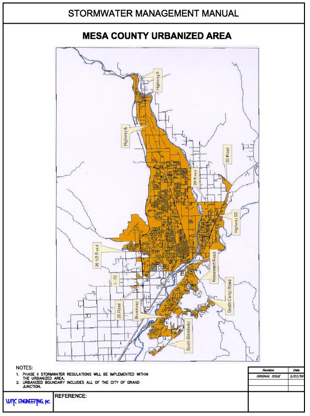
FIGURE 28.16.110
(Res. 40-08 (§ 403.9), 3-19-08)
28.16.120 Drainage facilities maintenance.
An important part of all storm drainage facilities is continued maintenance of the facilities to ensure they will function as designed. Maintenance of drainage facilities includes a number of routine tasks, such as removal of debris and sediment, and nonroutine tasks, such as restoring damaged structures.
All drainage facilities will be maintained to preserve their function, and shall:
(a) Be designed to minimize and facilitate maintenance.
(b) Include access to the entire drainage facility by dedication of rights-of-way, easements and tracts of land specifically for drainage purposes. Tracts or easement dedications shall prohibit uses and the construction of permanent improvements that restrict or block access. Specifically, detention and retention basins in subdivisions shall be located in tracts owned by the property owners’ association with an easement granted to the local jurisdiction. Basins for individual sites require neither a tract nor an easement but do require a maintenance agreement.
(c) Be incorporated in the lot grading for residential development in conformance with FHA lot grading Type A (all drainage to street) or Type B (drainage to front and rear lot line). Typical FHA three dimension Type A and Type B grading plans are shown below: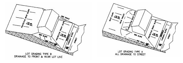
(d) Be maintained by the property owner, the developer and/or a homeowners’ association. Should the property owner fail to adequately maintain drainage facilities, the right is reserved to enter the property, upon proper notice, for the purpose of performing drainage maintenance. All maintenance costs shall be assessed against the owner(s) of the property.
(e) Include v-pans (two-foot minimum width) or storm sewer systems with an inlet in each yard when the grading plan creates backyard swales (regardless of swale slope). These must be installed prior to curb and gutter installation. Check with local municipality to confirm this requirement.
(Res. 40-08 (§ 403.10), 3-19-08)
28.16.130 Watershed transfer of storm runoff.
Drainage law recognizes the inequity of transferring the burden of managing storm drainage from one location or property to another. Liability questions also arise when the historic drainage continuum is altered. The diversion of storm runoff from one basin to another shall be avoided unless specific and prudent reasons justify and dictate such a transfer.
Stormwater diversion may be investigated during development of Watershed Master Plans and may be shown, in some instances, to be a viable option to address drainage and flooding problems. Tests for reasonableness of the potential transfer include:
(a) Determine where the runoff would go if the diversion system were to fail. If the flow stays in the historic basin, then the diversion may be reasonable.
(b) Determine if the downstream channel to which the drainage flows are being transferred is adequate to handle increased flows. If the channel has capacity, the diversion may be reasonable.
(c) Check condition where diversion fails during the major flood. If the downstream natural channel would have adequate capacity without adverse effects, the diversion may be reasonable.
(d) Determine if there would be any adverse water quality impact in either drainageway. If there is little or no impact, the diversion may be reasonable.
The development process can and will significantly alter the historic or natural drainage paths. When these alterations result in development outfall system that discharges back into the natural drainageway at or near the historic location, then the alterations (i.e., intra-basin transfer) are generally acceptable. However, when the subdivision outfall system does not return to the historic drainageway, an inter-basin transfer may result.
Inter-basin transfer as a drainage solution for new development is prohibited, unless allowed as a deviation/variance to this manual (see Chapter 28.08 GJMC) or as part of the Watershed Master Plan. During development of Watershed Master Plans where retrofit facilities are evaluated, inter-basin transfer may be a viable alternative in certain instances and will be reviewed on a case-by-case basis.
(Res. 40-08 (§ 403.11), 3-19-08)
28.16.140 Technical criteria – Stormwater management technology.
All storm drainage facilities shall be planned and designed in accordance with this manual. Criteria in this manual may be revised or amended as new technology is developed and/or experience gained in the use of these criteria. Exemptions to criteria and standards may be approved on a case-by-case basis.
Construction of any drainage facility not initiated within a two-year period from the time of construction plan approval must be reevaluated for approval and must receive re-approval.
(Res. 40-08 (§ 404.1), 3-19-08)
28.16.150 Technical criteria – Design storm events.
All new development and redevelopment shall plan for, design and construct drainage facilities to convey storm runoff from the minor storm and major storm events. Emergency overflow paths for drainage may be required for storms greater than the 100-year flood event as evaluated on a case-by-case basis.
Analysis and design of all drainage improvements for new development and significant redevelopment shall be based on projected future land use conditions, in accordance with local jurisdictional requirements and plans, except as may be modified by adopted Watershed Master Plans.
Culverts for local categorized streets may be designed for a flood more frequent than the 100-year, subject to the following conditions:
(a) The overtopping of the roadway during the 100-year event is limited to depths no greater than one foot and the downstream embankment is protected from erosion during overtopping.
(b) The culvert must pass the 10-year flood with a minimum of one foot of freeboard from the water surface to the lowest point in the roadway.
(c) The water surface elevation during the 100-year flood shall not cause additional flooding of adjacent properties and shall be compliant with local floodplain regulations.
All drainage systems shall be sized without accounting for peak flow reductions from on-site or local detention unless noted otherwise in the tables below. When required to size best management practices, the mean annual storm event shall be used.
A summary of requirements and design storms for the different types of stormwater facilities is presented in the following table.
|
STREETS |
|
|---|---|
|
Minor Storm |
Design Requirements |
|
2-year |
Flow depth ≤ 0.5 feet at gutter flow line |
|
|
Flow depth ≤ top of curb |
|
|
Flow velocity ≤ 8.0 feet per second |
|
Major Storm |
Design Requirements |
|
100-year |
Flow depth ≤ 1.0 foot at gutter flow line |
|
|
Flow velocity ≤ 8.0 feet per second |
|
|
Freeboard ≥ 1.0 foot at all finished floor elevations |
|
STORM DRAIN SYSTEMS |
|
|---|---|
|
Minor Storm |
Design Requirements |
|
2-year* |
Flow velocity between 2.5 and 15 feet per second |
|
|
EGL must remain below manhole rims and inlet throats |
|
Major Storm |
Design Requirements |
|
100-year* |
Flow velocity between 2.5 and 15 feet per second |
|
|
EGL must remain below manhole rims and inlet throats |
|
*These flow rates will be whatever the street inlets cumulatively accept during the two-year and 100-year storm events. |
|
|
CULVERTS |
|
|---|---|
|
Minor Storm |
Design Requirements for Roadways with right-of-way ≤ 80 feet |
|
10-year † |
Freeboard ≥ 1.0 foot at lowest point of drive lane(s) |
|
|
Approval of local jurisdiction to use minor storm design |
|
Major Storm |
Design Requirements for Roadways with right-of-way ≤ 80 feet |
|
100-year † |
Overtopping ≤ 1.0 foot at crown of roadway |
|
|
No additional flooding of adjacent properties |
|
|
Comply with all floodplain regulations |
|
|
Freeboard ≥ 1.0 foot at all finished floor elevations |
|
|
Design Requirements for Roadways with right-of-way ≥ 80 feet |
|
|
Flow depth ≤ 0.0 feet at crown of roadway |
|
|
Freeboard ≥ 1.0 foot at all finished floor elevations |
|
†Design of culverts may consider the effects of detention. |
|
|
DETENTION/WATER QUALITY |
|
|---|---|
|
Water Quality |
Design Requirements |
|
WQCV |
Design is per Volume 3 of the USDCM (see Chapter 28.80 GJMC) |
|
Detention |
|
|
Minor Storm |
Design Requirements |
|
10-year |
Design volume is the detention volume plus the WQCV |
|
|
Allowable release rates apply |
|
Major Storm |
Design Requirements |
|
100-year |
Design volume is the detention volume (do not add WQCV) |
|
|
Allowable release rates apply |
(Res. 40-08 (§ 404.2), 3-19-08)
28.16.160 Technical criteria – Storm runoff determination.
Storm runoff peaks and volumes for the design and evaluation of storm drainage facilities shall be determined using statistical analysis of recorded stream gage data, the rational method, or synthetic rainfall runoff models.
(Res. 40-08 (§ 404.3), 3-19-08)
28.16.170 Technical criteria – Streets.
Streets and street rights-of-way may be used to convey storm runoff from the minor and major events, subject to limitations set forth in this manual.
Storm runoff is permitted to cross street crowns at intersections, subject to limitations set forth in this manual.
Storm runoff is permitted to cross street crowns at culverts and bridges, subject to limitations set forth in this manual.
(Res. 40-08 (§ 404.4), 3-19-08)
28.16.180 Technical criteria – Flood proofing.
Flood proofing can be defined as those measures which reduce the potential for flood damages to properties within a floodplain. Measures can range from elevating structures to intentional flooding of noncritical building spaces (i.e., basement) to minimize structural damages.
Flood proofing is permitted in accordance with the provisions of the Mesa County Land Development Code. For other jurisdictions, contact the specific jurisdiction for specific guidance.
(Res. 40-08 (§ 404.5), 3-19-08)
28.16.190 Technical criteria – Alluvial fans.
Alluvial fans, consisting of sand and fine sediment, are subject to radical changes in shape, direction, depth, and flow carrying capacity during storm events. These changes increase the potential flood hazards of developing on alluvial fan areas.
Additional analysis and specialized design is required for any development located within an active alluvial fan. Requirements for analysis and design will be determined on a case-by-case basis.
(Res. 40-08 (§ 404.6), 3-19-08)
28.16.200 Irrigation facilities.
Irrigation conveyance facilities and reservoirs in the Mesa County area have historically intercepted the storm runoff from the rural and agricultural watersheds, generally without major problems. With urbanization of the watersheds, however, the storm runoff has increased in rate, quantity and frequency, as well as changing water quality. In developed areas, the irrigation facilities can no longer be utilized indiscriminately to convey storm runoff. New developments and redevelopment are prohibited from using irrigation facilities to convey storm runoff, except as described below.
(Res. 40-08 (§ 405), 3-19-08)
28.16.210 Irrigation facilities – Watershed analysis.
Drainage analysis and design shall be based on the assumption that an irrigation conveyance facility does not intercept storm runoff from the upper watershed and that the upper watershed is tributary to the watershed downstream of the irrigation conveyance facility, unless such irrigation conveyance facility has been designed to accommodate storm runoff and is part of an adopted Watershed Master Plan.
(Res. 40-08 (§ 405.1), 3-19-08)
28.16.220 Irrigation facilities – Discharge to irrigation conveyance facility.
Storm runoff shall be directed into pre-developed drainageways downstream of the irrigation conveyance facility. Storm runoff shall not be discharged into an irrigation conveyance facility, except as required by water rights law or the discharge is part of an adopted Watershed Master Plan or negotiated with an irrigation company.
Where irrigation ditches will serve as the outfall for a detention facility, the ditch water surface elevation shall be determined for the maximum irrigation flow of the ditch, and the stormwater surface elevation shall be determined for the combination of the maximum irrigation flow and the 100-year stormwater discharge of the detention facility.
(Res. 40-08 (§ 405.2), 3-19-08)
28.16.230 Irrigation facilities – Irrigation reservoirs.
New development is restricted to areas outside of:
(a) The reservoir’s high water line created by the design flood for the emergency spillway.
(b) The high water line created by the breach of a dam (except high hazard classified dams which have passed inspection by the State Engineer’s Office in accordance with § 37-87-105, C.R.S. et seq.). For dams without the breach high waterline identified, the developer shall analyze and define the high waterline resulting from such a breach.
(c) Existing or potential future emergency spillway paths, beginning at the dam and proceeding to the point where the flood water returns to the natural drainage course.
(Res. 40-08 (§ 405.3), 3-19-08)
28.16.240 Preservation of natural drainageways.
Natural drainageways are considered an important environmental feature that contributes to the image and livability of a community. Their value includes the ability to convey floodwater, to provide opportunities for trails and open space corridors, and to maintain natural vegetation and wildlife habitat to the greatest degree possible.
Preservation of natural drainageways, based on developed land use hydrology, is encouraged. Development of property shall not adversely affect any natural drainage facility or natural watercourse, and shall be subject to the following provisions:
(a) Drainageways shall remain in as near a natural state as is practicable. All proposed modification to the natural drainageway shall be subject to approval.
(b) When the flow rates, velocities, side slopes or other characteristics indicate a potential negative impact to the natural drainageway, the impact shall be mitigated in accordance with criteria set forth in this manual.
(Res. 40-08 (§ 406), 3-19-08)