


Chapter 32.24
SUMMARY AND RECOMMENDATIONS
Sections:
32.24.010 Preferred alternative.
32.24.050 Recommendation for streetscape kit-of-parts.
32.24.070 Streetscape new development.
32.24.090 Summary of Grand Junction sign code strategies and recommended improvements.
32.24.100 Implementation strategies.
32.24.010 Preferred alternative.
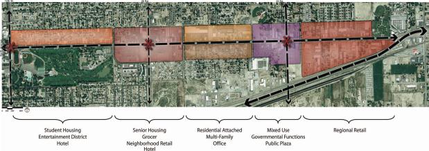
The predominant elements of the preferred alternative are:
(a) A student and entertainment district in proximity to Mesa College would also provide student housing, after 5:00 p.m. activities and the opportunity for a quality hotel to serve the area.
(b) A neighborhood center where senior housing is located in proximity to a quality grocer, neighborhood retail, and the potential for a hotel to serve the hospital and surrounding neighborhood.
(c) A multifamily and attached residential district connecting to the neighborhoods to the north, and potential for office space to the south.
(d) A mixed use area with residential over retail incorporated with the governmental functions and public plazas to create a gateway for the 29 Road intersection.
(e) Regional retail to anchor the east end of the corridor.
(Res. 174-07 (Exh. A), 12-3-07)
32.24.020 Key projects.
The key projects board presented the three catalytic areas identified that would provide the greatest results for improvement and attraction of the North Avenue Corridor. These key projects are the primary areas in which investment can best empower the revitalization of North Avenue.
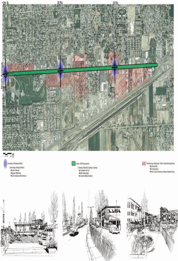
Concentrated efforts in streetscape treatment, community identity, way finding, signage and architecture at the key intersections of 12th Street, 28 and 29 Roads would launch the future development of the corridor area.
The overall improvements of the streetscape, primarily around the community/development nodes, would set a foundation that is enticing for new development and improves the reputation and use of North Avenue.
Areas surrounding the key development nodes provide the greatest opportunity for land consolidation and large development projects that would create the greatest impact and results.
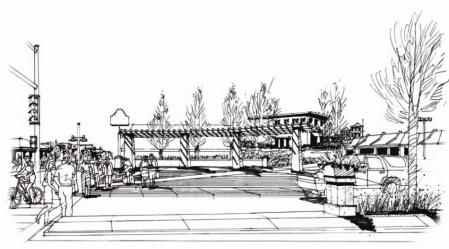
Artist renderings provide a visual character and feel for these key development concepts proposed.
(a) The illustration above presents a vision of a civic plaza where the intersection treatments would provide for clear and safe pedestrian traffic movement. The civic space would serve as a gathering space and as an entry marker giving the North Avenue Corridor an identity. Existing restaurant spaces could be maintained while new residential development would be tucked around existing building pads.
Such projects could be realized at the intersection of North Avenue and 12th Street, where a student and entertainment district would create a marker and gathering space for students as well as the surrounding community. This potential project could serve the needs for higher quality restaurants, entertainment, and a student housing district.
This key project ultimately could serve as the catalyst to entice development and the further revitalization of the greater North Avenue Corridor.
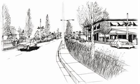
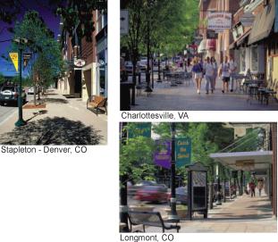
(b) Improvements to the streetscape are another key project that would further promote the revitalization of this corridor. A pedestrian-friendly environment using native, xeric plant materials that are easily maintained while yet providing an appealing and beautiful streetscape are important to attract pedestrian traffic.
Median cuts and numerous parking lot accesses will be consolidated. Traffic level of service and access will not be impacted.
Intersections and medians would be improved while a cohesive kit-of-parts would bring character to the corridor. Improved sidewalks, lighting, street furniture and signage will improve the pedestrian, bike and vehicular access, allowing for retail and commercial to thrive in a safe environment.
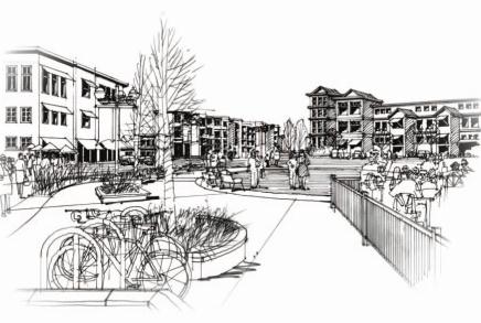
(c) Finally, the assembly of parcels of land where a large development can build momentum and entice greater investment would bring the vitality back to North Avenue. The illustration presents retail and commercial uses with residential above combined with a plaza and patios. Senior housing, a grocer and neighborhood retail provide an environment to attract individuals interested in living within a vibrant community. Surrounding neighborhoods would further sustain the community node.
Infill development such as this will assist in a neighborhood center as well as a regional destination promoting activity beyond 5:00 p.m. and on weekends.
(Res. 174-07 (Exh. A), 12-3-07)
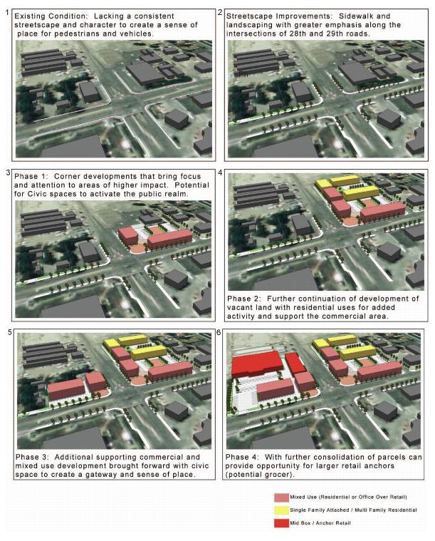
32.24.030 Phasing concept.
The phasing of development would allow for existing buildings and uses to slowly become integrated into the larger vision of the North Avenue Corridor.
Illustrated below is an example of how such phasing could occur:
(Res. 174-07 (Exh. A), 12-3-07)
32.24.040 Transportation.
(a) There are 25 intersections within the North Avenue study area, not including driveways to abutting property. Sixty percent are T-intersections (a three-leg intersection) and 40 percent are cross-intersections (a four-leg intersection). Intersections, by their very nature, create numerous conflicts between vehicles, bicycles, and pedestrians. For instance, there are 32 vehicle/vehicle conflict points and 16 vehicle/pedestrian conflict points at every four-leg intersection.
(b) The design of an intersection requires a balance between the needs of vehicles, pedestrians, bicyclists, freight and transit. The following are attributes of good intersection design for pedestrians, as documented in AASHTO’s Guide for the Planning, Design and Operation of Pedestrian Facilities (2004).
(1) Clarity – Making it clear to drivers that pedestrians use the intersections and indicating to pedestrians where the best place is to cross;
(2) Predictability – Drivers know where to expect pedestrians;
(3) Visibility – Good sight distance and lighting so that pedestrians can clearly view oncoming traffic and be seen by approaching motorists;
(4) Short Wait – Providing reasonable wait times to cross the street at both unsignalized and signalized intersections;
(5) Adequate Crossing Time – The appropriate signal timing for all types of users to cross the street;
(6) Limited Exposure – Reducing conflict points where possible, reducing crossing distance and providing refuge islands when necessary; and
(7) Clear Crossing – Eliminating barriers and ensuring accessibility for all users.
(c) Signalized intersections typically have marked crosswalks, Walk/Don’t Walk indications, and regulatory signing. Motorists expect pedestrians and pedestrians are reasonably well protected when crossing at these locations. The study corridor currently has nine signalized intersections. Most of these signals are located at one-quarter-mile intervals. The most notable exception is between 12th Street and 23rd Street, where there is no signalized intersection for approximately three-quarters of a mile. In urban areas, pedestrians must be able to cross streets at regular intervals. They rarely will go more than 300 to 400 feet out of their way to take advantage of a controlled intersection. Consequently, the crossings at uncontrolled locations deserve serious consideration as urban arterial corridors redevelop. Treatments commonly used on higher-volume multilane streets throughout the United States include: high-visibility markings with double-posted pedestrian crossing signs; refuge islands; flags; and flashing beacons. Signals that are used just for pedestrian crossings are used primarily at midblock crossings.
(Res. 174-07 (Exh. A), 12-3-07)
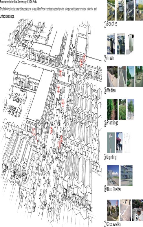
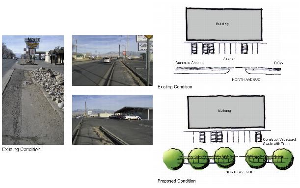
32.24.050 Recommendation for streetscape kit-of-parts.
The following illustration and images serve as a guide of how the streetscape character using amenities can create a cohesive and unified streetscape.
(Res. 174-07 (Exh. A), 12-3-07)
32.24.060 Streetscape.
The creation of a more unified street edge condition along North Avenue will improve the overall character of the corridor. This can be accomplished by consolidating existing curb cuts and parking lots, providing more definition to vehicular entry ways, and adding walks and plantings. The addition of pedestrian-scale street lights, trees, benches and other amenities will create a more pedestrian-friendly environment, and encourage local residents to walk or bike along the corridor. Most of these improvements can be made within the existing street right-of-way. Suggested improvements outside of the right-of-way can be made without the removal of existing structures.
(a) Drainage Way Adjacent to Street. In areas where there are open concrete channels adjacent to the street, suggested improvements include the creation of a generous vegetated swale to collect, filter, and distribute stormwater, as well as provide an irrigation source for planted trees. The addition of an attached walk, defined curb cut entrances, and pedestrian light fixtures will also enhance and define the street edge.
An alternative would be to provide a covered pipe to convey this drainage. This proves less advantageous relative to cost, construction caused delays to traffic and the loss of utilizing this runoff for future plantings.
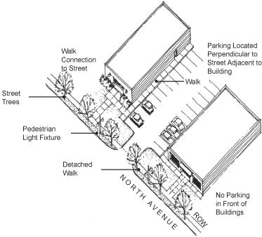
(b) Building Adjacent to Street. In areas where buildings front the street, suggested improvements include sidewalks that connect building entrances to walks along North Avenue, defined curb cut entrances, and the relocation of parking between buildings. These improvements will enhance the street edge by reducing the number of parked cars in front of building entrances, provide space for street tree plantings, and reduce the expanse of asphalt. This makes the buildings easier to see and identify from North Avenue. Additional sidewalks provide a clear, safe pedestrian path between parking lots to building entrances, and provide pedestrian connections to North Avenue.
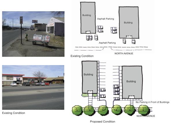
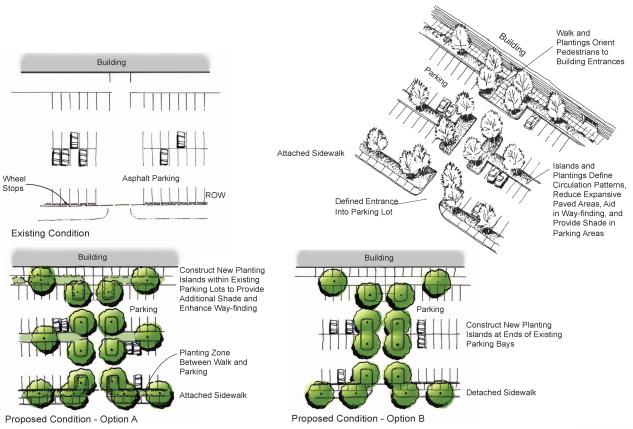
(c) Parking Lot Adjacent to Street. In areas where parking lots front the street, suggested improvements include defined curb cut entrances, added sidewalks, and additional plantings to define parking lot circulation and enhance way finding. Tree plantings can be added to existing parking lots by removing asphalt at the end of the parking bays, defining an entrance into the lot (Option B). Another option is to include planted islands between parking bays, which is especially effective in reducing the expanse of paved areas and urban heat islands often found in large parking lots (Option A). Attached or detached sidewalks can be added adjacent to North Avenue, depending on the specific condition and width of the right-of-way. Fencing, 42 inches tall, can also add positive streetscape character. The fencing should be steel and open, and may be an opportunity to incorporate art, static or kinetic, and color.
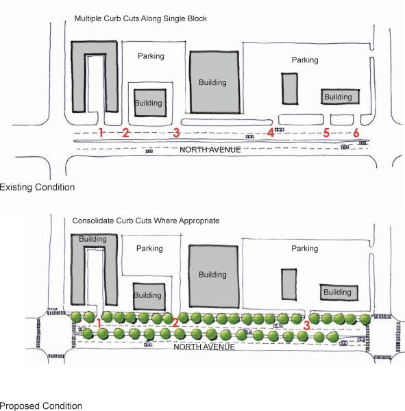
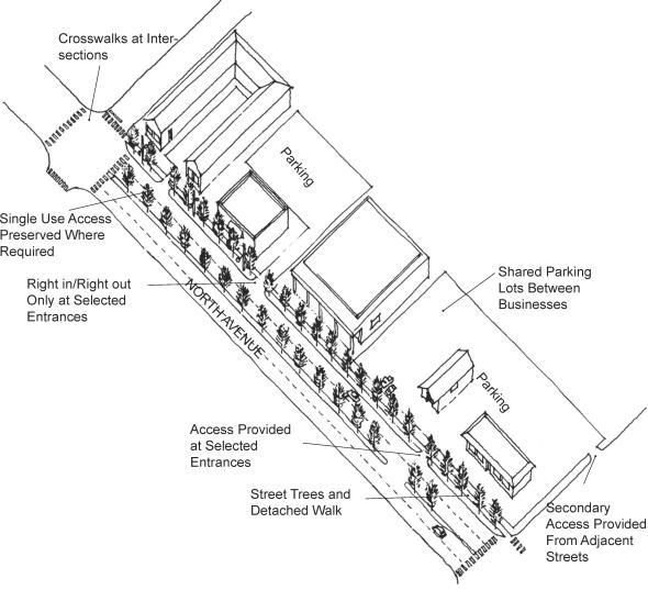
(d) Curb Cut Consolidation. Reducing the quantity of curb cuts along North Avenue will greatly enhance the overall character of the corridor, and improve vehicular and pedestrian circulation. Curb cuts can be consolidated in areas where parking lots can be linked and shared by adjacent uses. Consolidating curb cuts also provides additional space for plantings and sidewalks adjacent to North Avenue within the right-of-way and less discontinuity of the sidewalk.
(Res. 174-07 (Exh. A), 12-3-07)
32.24.070 Streetscape new development.
Areas identified for redevelopment along the corridor provide an opportunity to greatly enhance the character of the corridor, by creating pockets of redevelopment that will stimulate further improvements. As shown on the land use plans, these areas of redevelopment will consist primarily of additional residential, office, retail/commercial areas, or new regional store developments.
In all cases, each undertaken project should provide connectivity to the pedestrian network and include public open space.
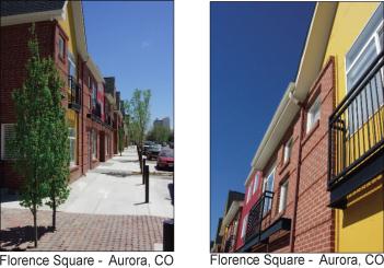
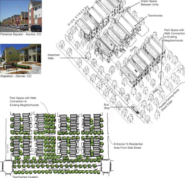
(a) Residential. Clustered townhome developments adjacent to North Avenue will provide a distinct living option for residents along the corridor that is currently unavailable in the region. Located within walking distance of shopping, restaurants, bus service, and employment opportunities, townhomes offer a very desirable alternative to single-family housing. A green corridor in a walking environment creates a pedestrian connection between the existing neighborhoods and North Avenue, providing convenient access to the street for existing residents. On-street parking provides parking for visitors.
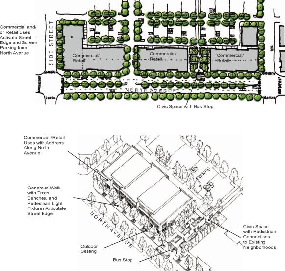
(b) Commercial/Retail. New commercial/retail uses along North Avenue are located close to the street, which helps to activate the street edge. Generous sidewalks with spaces for outdoor seating, active open space, pedestrian lights, and street trees enhance the character of the corridor. Building signage can be located directly on the face of the buildings, which can be readily identified from passersby on North Avenue. Front door access to retail/commercial uses is provided on the interior side, providing easy access from nearby parking, with back door service access provided along North Avenue. Civic spaces such as plazas, corridors, or pocket parks create a permeable frontage along North Avenue that provides easy pedestrian flow between the street and commercial or retail uses.
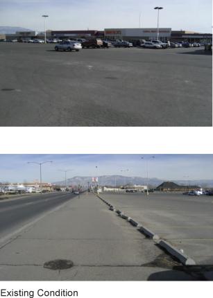
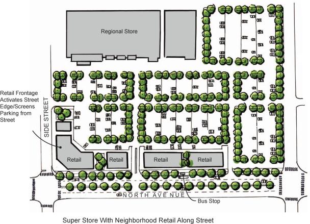
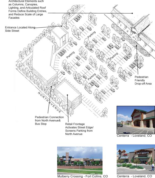
(c) Regional Store. New regional store developments, proposed as infill projects, along North Avenue can be designed to minimize the impacts of large expanses of asphalt parking. This can be accomplished by locating retail stores at the edge of North Avenue, which activates the street edge, and screens the expansive parking lots from view from North Avenue. Interior parking lots can be shared between the super store and retail uses. Architectural elements such as canopies, columns, and articulated roof forms help to define the building entries of the super store, and reduce the scale of large facades. This approach will provide a more pedestrian-scaled environment for merchants, and create a more inviting facade. Entrances to the super store should be located from a side street, which will prevent excessive traffic build up along North Avenue.
(Res. 174-07 (Exh. A), 12-3-07)
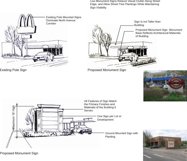
32.24.080 Signage.
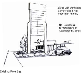
Improvements to signage along North Avenue can be accomplished by minimizing the quantity of pole-mounted signs and replacing them with monument signs. This will aid in reducing the visual clutter of the pole-mounted signs, and also provide an opportunity for street trees to be planted. Because monument signs are low, they are not in conflict with the larger canopy of the street trees, and can be readily seen from passing traffic. Further detail on signage and recommended adjustments to the Grand Junction sign code are provided.
This philosophy supports the neighborhood or district concept, in that distinctions are to areas and not individual pad development. This encourages the walking environment and provides for a group of retailers to engage the property as a whole.
(Res. 174-07 (Exh. A), 12-3-07)
32.24.090 Summary of Grand Junction sign code strategies and recommended improvements.
Summaries of particular sections from the Grand Junction sign code are provided below, indicating where the current Grand Junction sign regulations could be strengthened or amended to improve the overall visual quality and pedestrian scale of North Avenue. Currently, the majority of signs along North Avenue fall within these existing regulations:
(a) Sign Location (GJMC 21.36.070(c)(3)).
(1) Code Summary. Grand Junction’s current sign regulation allows signs most anywhere on the property being advertised, and the total square footage allowed for a single sign is not to exceed 300 square feet.
(2) Recommended Improvements.
(i) No signs permitted at the right-of-way.
(ii) Establish setbacks from the right-of-way.
(iii) Limit square footage of signs based upon to-be-established criteria.
(b) Building Mounted Signage (GJMC 21.36.070(c)(5)).
(1) Code Summary. There is no overall maximum square footage for wall-mounted signs, although the formula is similar to other sign code regulations. Each building will have its own maximum square footage, rather than a universal not-to-exceed size.
The language also allows for wall-mounted signs on any side of the building facing a street, thus a corner lot could have two signs, each with a different sign allowance.
The regulation allows for roof signs, up to 40 feet above grade in height. In addition, the regulation permits more than one building-mounted sign (wall-mounted, roof sign, or projecting) per structure as long as the maximum square footage is not exceeded.
(2) Recommended Improvements.
(i) Limit square footage for building-mounted signs based upon to-be-established criteria.
(ii) Limit number of signs to one per building or tenant.
(iii) Prohibit roof signs.
(c) Projecting Signage (GJMC 21.36.070(c)(6)).
(1) Code Summary. A minimum size (12 square feet) is given for projecting signs rather than a maximum, if the projecting sign is the only sign on the building.
(2) Recommended Improvement.
(i) Limit square footage of projecting signs based upon to-be-established criteria.
(d) Freestanding Signage (GJMC 21.36.070(c)(7)).
(1) Code Summary. The square footage and height limitations are calculated similar to other sign code regulations, but allow for greater height (25 feet for two traffic lanes and 40 feet for four traffic lanes) and maximum square footage than other regulations. The sign square footage is also calculated based upon property frontage rather than building face frontage.
Signs are allowed to be installed at the right-of-way, with no setback requirements.
(2) Recommended Improvements.
(i) Limit square footages and heights of signs based upon to-be-established criteria based upon building linear feet rather than property linear feet.
(ii) Lower heights of signs from what is now permitted.
(iii) No signs permitted at the right-of-way.
(iv) Sign design reflects the associated building architecture.
(v) Signs shall be attached to the ground or with minimal space between the sign and the ground.
(e) Off-Premises Signage (GJMC 21.36.070(d)).
(1) Code Summary. Off-premises signage (building-mounted, freestanding, or roof signs) is allowed in C-2 (General Commercial) and I-1 and I-2 (Industrial) zones. Maximum height is 40 feet, and square footage must be between 15 square feet and 300 square feet. Some municipalities are not allowing any off-premises signs within the City limits.
(2) Recommended Improvement.
(i) Prohibit off-premises signage.
(f) Recommended Sign Implementation Measures from Other Municipal Sign Codes. The following are representative regulations found within the sign codes from Denver, Fort Collins, Longmont, Greeley, and Loveland. Typically, it was found that heights and square footages were regulated, often based on a formula determined by the setback distance from the face of curb or edge of pavement and/or the linear feet of building facing the street. This summary does not provide that level of detail, but rather an overview of suggested strategies.
(1) General.
(i) Existing on-premises signs which have become nonconforming because of subsequent Code amendments shall be brought into conformance within 15 years of the date of amendment.
(ii) All features of the sign, including illumination, sign cabinet, base, color, lettering, and materials shall match the primary finishes and colors of the associated building(s) which it serves.
(iii) All signs which are greater than four square feet in area, except ground signs or signs that replicate a business logo, must be comprised only of individual letters or cabinets where only the letters are illuminated.
(iv) Signs shall be professionally designed and fabricated from quality, durable materials.
(v) No roof signs.
(vi) Lighting shall be indirect.
(2) Maximum Size of Letters.
|
Use |
Maximum Letter Height |
Maximum Logo Height |
Maximum Cabinet Height |
|---|---|---|---|
|
Auto-related, roadside, and business services |
12" |
18" |
18" |
|
Convenience shopping center |
18" |
24" |
24" |
|
Neighborhood services center, neighborhood commercial district |
24" |
30" |
30" |
(3) Sign Location.
(i) Signs will be set back from the right-of-way based upon the sight distance triangle requirements, zoning district, or size of sign.
(ii) No signs allowed within the right-of-way, with the exception of projecting signs which meet all requirements set forth in the regulations.
(iii) No off-premises signs.
(iv) All freestanding signs shall be located to be compatible with required landscaping, including street trees at maturity, so that the public views of the sign will not be obstructed.
(4) Freestanding/Ground Signage.
(i) Freestanding or ground signs comply with the following requirements:
|
Use |
Maximum Area per Sign Face |
Maximum Number of Signs per Street Frontage |
Maximum Height |
|---|---|---|---|
|
Auto-related, roadside commercial, and business services |
Primary – 32 SF |
Primary – 1 |
Primary – 5 ft. |
|
Convenience shopping center |
Primary – 40 SF |
Primary – 1 |
Primary – 8 ft. |
|
Neighborhood services center, neighborhood commercial district |
Primary – 55 SF |
Primary – 1 |
Primary – 10 ft. |
|
Secondary – 32 SF |
Secondary – 1 |
Secondary – 6 ft. |
(ii) Freestanding signs only permitted with a supporting sign structure, the width of which exceeds 70 percent of the width of the sign face.
(iii) Freestanding or ground signs shall have no more than two faces.
(iv) Maximum height for freestanding signs shall be 18 feet above grade; and for ground signs shall be 12 feet above grade. (Another code said maximum six-foot height for freestanding.)
(v) All freestanding signs shall be of a monument design including a monument base attached to the ground with no or minimal space between the sign cabinet and the monument base (no pole signs).
(vi) Monument bases shall be equal or greater (up to 20 percent greater) in width and length than the sign cabinet. Sign cabinets for freestanding signs shall not exceed 24 inches in width.
(vii) Multi-tenant buildings or developments are allowed one sign per lot or development parcel (no individual freestanding or ground signs).
(5) Projecting Signage.
(i) Not allowed to be located on the same street frontage as a freestanding sign.
(ii) Shall not exceed 30 square feet for all faces.
(iii) Shall not extend more than five feet from the building face nor extend beyond the curbline of any street or parking area.
(iv) Minimum of eight feet of clearance from the ground, and a maximum of 25 feet, and shall not extend beyond the roofline or parapet wall.
(v) Only one per building or tenant.
(vi) Not allowed on a wall that already has a wall-mounted sign.
(6) Building-Mounted Signage.
(i) No building-mounted sign shall exceed 100 square feet.
(ii) Multi-tenant buildings allowed one wall sign per street frontage of business.
(iii) Only one building mounted sign per building (single tenant). Shall not project above the roofline.
(7) Awning Signage.
(i) Signs on canopies or awnings are limited to the name of the building, business and/or address of the premises.
(ii) Shall not exceed 50 square feet per face in area.
(iii) Only allowed on first story of a building.
(iv) Minimum clearance shall be eight feet.
(g) Suggested Steps to Implementing New Signage Approach Along North Avenue. The following steps are suggestions for implementing a new signage strategy along the North Avenue Corridor. This strategy will require amending the existing sign code to incorporate the appropriate level of restrictions within the corridor.
(1) Determine Desired Signage Aesthetic. Determine the appropriate level of regulations for signage based upon other similar Colorado communities, as well as the desired aesthetic and scale of the signs within the corridor.
(2) Determine How to Approach Existing Nonconforming Signs. Decide whether to require existing nonconforming signs to be improved within an appropriate time frame, and/or require compliance to new sign code amendments at time of business transition or sale. For example, Fort Collins requires all existing signs to be in compliance with the updated sign code within 15 years.
(3) Amend the Sign Code Appropriately. Determine if this is a City-wide amendment, or limited to a special zoning district for North Avenue. Amend the City sign code with the desired adjustments, and begin transitioning out the old signs.
(Res. 174-07 (Exh. A), 12-3-07)
32.24.100 Implementation strategies.
|
|
West |
Central |
East |
|||
|---|---|---|---|---|---|---|
|
Barriers |
• |
Central GJ losing ground to fringe for commercial development |
• |
Central GJ losing ground to fringe for commercial development |
• |
Central GJ losing ground to fringe for commercial development |
|
• |
Retail and commercial uses too spread out – lacking critical mass |
• |
Veterans hospital may not generate enough demand for spin-off medical office development |
• |
Retail and commercial uses too spread out – lacking critical mass |
|
|
• |
Retail and commercial uses too spread out – lacking critical mass |
|||||
|
Strategies |
• |
Capitalize on proximity to college and downtown through marketing efforts, product mix and positioning |
• |
Capitalize on proximity to hospital and park through marketing, product mix and positioning (including actual physical connectivity) |
• |
Capitalize on substantial infrastructure investment in north-south connection (along with presumably softer land assembly costs) to pursue regional retail opportunity |
|
• |
Educate Council about this market reality and prepare them for filling the gap of catalyst projects resulting from inflated land prices and other factors |
• |
Encourage hospital, or unrelated clinics, to explore partnership opportunities |
|||
|
• |
Encourage mixed uses including affordable residential and multifamily |
|||||
|
• |
Consider an urban renewal district to assist with on-site and off-site costs for qualifying elements |
|||||
|
|
West |
Central |
East |
|||
|---|---|---|---|---|---|---|
|
Barriers |
• |
Fragmented ownership/difficulty in assembly |
||||
|
• |
Unsupportable land costs |
|||||
|
Strategies |
• |
Work with private and nonprofit interests to assemble and hold opportunity sites |
• |
Problem is less severe near logical development node – probably can use traditional land assembly |
||
|
• |
Share market opportunities with various audiences to encourage investment |
|||||
|
• |
Use range of mechanisms – land swaps, low-interest loans, acquisition/write-down |
|||||
|
• |
Consider establishing appropriate districts as holding entities |
|||||
|
|
West |
Central |
East |
|||
|---|---|---|---|---|---|---|
|
Barriers |
• |
Inadequate size and shape of lots for redevelopment |
||||
|
• |
Building relationship to the street (inconsistent setbacks) |
|||||
|
• |
Balancing the role of the street (cars vs. pedestrians) |
|||||
|
Strategies |
• |
Maintain (City) flexible position on the use and width of alleys (if relevant) in select locations |
||||
|
• |
Create street standards for building setbacks, sidewalk width, signage, awnings, etc. sensitive to the feasibility of the remaining building envelope |
|||||
|
• |
For stores that require surface parking in front, require heightened landscaping or pad site development with interior parking – remaining sensitive to sight-lines |
|||||
|
• |
Establish street standards – define the street’s role by district based on the vision and desired character |
|||||
|
• |
Update any transportation plans relative to desired district functions, including encouraging public transportation through increased comfort and security of stops |
|||||
|
• |
Link parking lots, minimize curb cuts and consolidate driveways – selectively – where feasible |
|||||
|
• |
Redesign intersections and access points within the nodes to simplify and coordinate signal sequences |
|||||
|
|
West |
Central |
East |
|||
|---|---|---|---|---|---|---|
|
Barriers |
• |
Over-zoned for commercial – limiting development of housing |
||||
|
Strategies |
• |
Consider overlay district that is more supportive/encouraging of mixed use |
||||
|
• |
Revise regulations to eliminate barriers to investment in neighborhoods on the corridor; promote density and greater variety of residential products (i.e., density bonuses) |
|||||
|
• |
Encourage the introduction of residential development within nodes and at key locations; fill financial gaps, and support demonstration projects (look for institutional partners) |
|||||
|
• |
Where necessary, assist with assembling properties to accommodate a range of product types (workforce, student, senior, etc.) |
|||||
|
• |
Eliminate regulatory barriers which preclude or delay redevelopment buildings for residential use (building codes, limits on adjacency among uses, etc.) |
|||||
|
• |
Work with private and nonprofit interests to provide opportunity sites for residential development |
|||||
|
|
West |
Central |
East |
|||
|---|---|---|---|---|---|---|
|
Barriers |
• |
Lack of committed “cheerleader” |
||||
|
• |
Limited examples of creative financing strategies (lack of catalyst/demonstration projects) |
|||||
|
• |
Homeless shelter is a deterrent to redevelopment |
|||||
|
Strategies |
• |
Request Council support for participation in at least two demonstration projects – enlisting the participation of existing property owners (if feasible), identifying partners, soliciting lender support, and committing a range of tools to assist with filling the gap |
||||
|
• |
Once a “tool box” of incentives has been assembled, publish a request for development, nonparcel specific to encourage investment |
|||||
|
• |
Through this corridor plan process, identify individuals and organizations which have the desire and resources to continue this effort and ensure the implementation strategy is implemented |
|||||
|
• |
Develop a range of “stories” which speak to the interests of different audiences – physical, fiscal, market, financial, etc. – educating about the opportunities and commitment to overcome barriers |
|||||
|
• |
Encourage transitional programs (e.g., job training, adult education) that provide positive daytime activities for homeless shelter population |
|||||
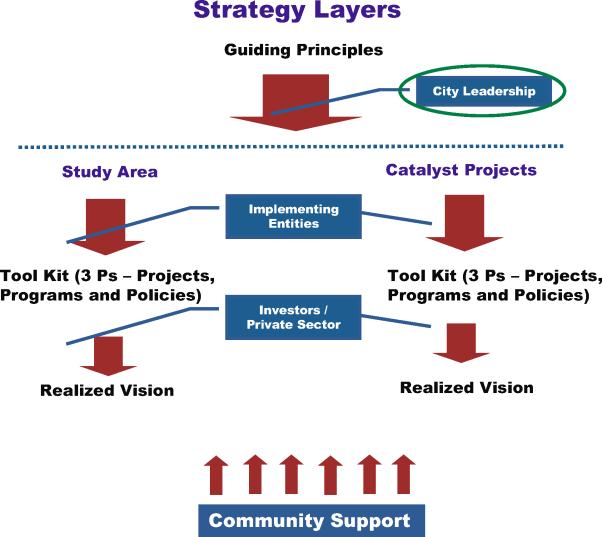
(b) Implementation Priorities – Roles and Responsibilities.
|
City Leadership |
Support at least two demonstration projects (catalyst projects) – commit support for the use of a range of gap filling tools |
|
Once potential incentives are identified – publish a request for development |
|
|
Consider the range of district mechanisms which could potentially fund improvements in the corridor |
|
|
New Initiatives |
|
|
Implementing Entities (i.e., City Staff, Advocacy Entities, etc.) |
Continue to monitor the market and development climate – establish benchmark database |
|
|
Develop targeted marketing materials – solicit regional retail opportunity |
|
|
Establish street standards |
|
|
Link parking lots, minimize curb cuts and consolidate driveways – within nodes |
|
|
Complete regulatory review – eliminate gaps and barriers |
|
Investors/Private Sector |
Host developer/lender (“delivery system”) information meetings – progress updates |
|
|
Share development challenges – open book and open dialogue |
|
Community |
Continue to participate – get educated |
|
|
Support leadership decisions which advance the vision |
(c) Implementation Framework.
(Res. 174-07 (Exh. A), 12-3-07)