


Chapter 33.04
INTRODUCTION
Sections:
33.04.050 Elements of the 24 Road Corridor “Preferred Plan.”
33.04.060 Implementation of the Subarea Plan.
33.04.010 Executive summary.
The 24 Road Corridor Subarea Plan (the “Subarea Plan”) has been developed to articulate a vision, plan and strategy for the future use and development of the project area, which comprises approximately 1,000 acres in the vicinity of 24 Road between Interstate 70 and the Mesa Regional Mall on Patterson Road. The Subarea Plan is intended to assist the City of Grand Junction, utility and service providers, and property owners in the project area as they plan for the future use and development of the area, including important infrastructure investments that will be necessary to serve future development. Figure ES-1 shows the location of the 24 Road Corridor Subarea.
(Res. 109-00, 11-1-00)
33.04.020 Planning process.
In September, 1999, the City of Grand Junction initiated a planning process for the 24 Road Corridor. The purpose of this study was to evaluate current and projected market conditions in the 24 Road Corridor, formulate and evaluate different land use and development alternatives for this area and identify a preferred pattern of development and to formulate an implementation strategy. BRW, Inc., of Denver, a multi-disciplinary planning and engineering firm, and Leland Consulting Group, an economics firm, were hired to prepare the study.
The consultant team worked with City staff and a 15-person Council-appointed Steering Committee, as well as property owners and their representatives, to examine the issues and options related to development along 24 Road. There were a total of seven workshops conducted by the consultants with the 24 Road Corridor Steering Committee. The findings, conclusions and recommendations of the planning process are presented in this report.
(Res. 109-00, 11-1-00)
33.04.030 Issues.
The 24 Road Corridor subarea planning process was in part an outgrowth of public reaction to the zoning proposed in the 1996 Grand Junction Growth Plan. The primary criticism was voiced by property owners, who suggested that the zoning proposal was in conflict with market forces shaping land uses and development patterns along 24 Road. This important issue was then incorporated into the project scope to evaluate various land uses and development patterns, including the City-proposed zoning plan, and their concurrence with regional market forces and community desires.
An additional concern of the property owners is the proposed expansion of 24 Road from two lanes to three lanes. Once again, the property owners believe that the expansion is not reflective of demand. They suggest that 24 Road be expanded to a five-lane boulevard or parkway, as a catalyst for the intensity of development they believe will occur in the area.
(Res. 109-00, 11-1-00)
33.04.040 Market analysis.
A market study was conducted to quantify demand for various land uses, including those proposed by the City and those proposed by the property owners. Growth trends, supported by traffic analysis, show continued growth, particularly in residential uses, in the northeast and southwest quadrants of the City. Traffic volumes east and west, along U.S. Highway 6/50, support commercial land use concentration along the Corridor.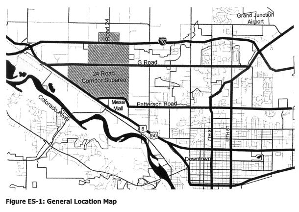
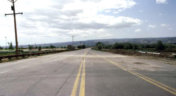
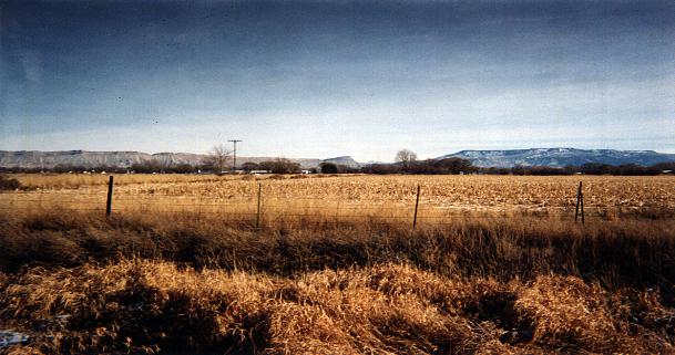
View to the Colorado Monument from 24 Road
The City’s concern that large-scale commercial development might undermine existing activity centers is valid. There appears to be a sufficient supply of existing commercially zoned land and built space to meet projected demands over the next 10 years. The market study concluded that the corridor might receive as much as a 25 percent share of future nonresidential development, which could begin to compete with other locations in Grand Junction. To address this, an important element of the 24 Road Subarea Plan and implementation will be to limit the types of retail commercial uses in the area. This would avoid undermining existing regional retail centers while allowing for neighborhood retail uses and some regional employment/commercial uses for which there are suitable alternative sites (i.e., large acreage) in the Grand Junction area. There does not appear to be a conflict regarding office, industrial and other employment uses.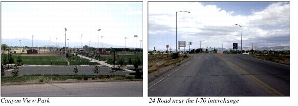
The market analysis supports the concept of commercial clustering near Mesa Mall with perhaps some expansion along U.S. Highway 6/50, due to traffic volumes along the highway. Although it is difficult to be extremely “location specific” in a market as small as Grand Junction, very little evidence was found to support the demand for a significant amount of commercial land uses along 24 Road north of Patterson. It should be noted, however, that the analysis likewise does not indicate a significant demand for the amount of land area dedicated to multifamily uses as proposed in the Growth Plan.
(Res. 109-00, 11-1-00)
33.04.050 Elements of the 24 Road Corridor “Preferred Plan.”
The Steering Committee reached a general consensus on the following features of the “Preferred Plan”:
(a) Vision Statement.
(1) Achieve high quality development in the corridor in terms of land use, site planning and architectural design.
(2) Provide for market uses that complement existing and desired uses and benefit the Grand Junction community.
(3) Take advantage of and expand upon existing public facilities in the corridor to create a “civic” presence.
(4) Achieve a distinctive “parkway” character along the roadway that can serve as a gateway to the Grand Junction community.
(5) Encourage development that is consistent with the Growth Plan.
(6) Adjust and/or amend the Grand Junction Land Use Code and Growth Plan to achieve the 24 Road Corridor vision, concept and plan and to create a predictable environment for future development of the area.
(b) Subarea Plan Concept. The Subarea Plan is to provide a land use and transportation framework for future development in the 24 Road Corridor project area that:
(1) Allows for flexibility in land use (type, intensity and density), while recognizing inherent differences between development on small parcels compared with larger parcels.
(2) Establishes a transportation network that interconnects to create a logical urban pattern.
(3) Establishes a high quality image through zoning, design standards and public improvements.
(c) Subarea Plan Elements.
(1) Image. The Subarea Plan is intended to foster the development of a high quality environment within the corridor that reflects its importance as a gateway to Grand Junction. Public improvements should establish this quality within the public realm (road right-of-way and public open space) and create a “parkway” character. This overall theme and sense of quality should be carried over to private sites by applying design standards and guidelines. The Subarea Plan recognizes that a development “catalyst,” such as a golf course or recreational facility, would encourage high quality development as well as contribute positively to the area’s image.
(2) Open Space/Public Facilities. Canyon View Park already establishes a “civic” character for the area, as well as providing valuable open space and recreational facilities. This character should be continued through the development of 24 Road as a landscaped parkway, including regional trails connecting the park and the Colorado River. Future open space/public facilities may include a golf course or other recreational amenity, which could be developed as a public/private venture as part of a larger land holding, assemblage or cooperative venture among smaller landowners.
(3) Circulation. U.S. Highway 6/50, 24 Road, Patterson Road and G Road currently comprise the major road network for the area. Successful development in the future will depend upon the creation of a secondary road system that provides continuity of travel, access to sites and alternative routes north/south and east/west in the area. Future rights-of-way for public streets should be reserved.
Expansion of 24 Road as a five-lane landscaped parkway with a landscaped median is a key implementation element that should occur as soon as possible. It will “set the tone” for development in the area and should be coordinated with Colorado Department of Transportation (CDOT) plans for the interchange.
(4) Land Use. Identify the most appropriate uses for different areas in the 24 Road Corridor, according to the following categories:
(i) Rural Residential. Rural residential land north of I-70 is consistent with the Growth Plan, including the current church site northwest of the I-70 interchange.
(ii) Residential. Low- and medium-density residential on individual parcels or as part of a planned development.
(iii) Commercial. Allow for a commercial node in the northeast corner of the I-70 interchange, as well as expansion of commercial uses adjacent to the Mesa Mall area.
(iv) Industrial. Continue industrial uses in the western sector between G Road and U.S. Highway 6/50.
(v) Park/Open Space. Existing open space includes the existing Canyon View Park. Future public open space will be along the Leach Creek corridor connecting to the Colorado River trail and open space corridor.
(vi) Planned Development. Planned development in the remaining areas should include a mixture of uses: employment, residential and open space. Retail commercial may be appropriate in the form of nodal development (such as 24 Road and G Road).
Although specific site development plans have not yet been approved for properties in this area, they will need to be approved as part of the City review process, which will rely in part on a comprehensive set of design standards and guidelines.
Owners of small parcels will be required to follow existing zoning or combine their property with others to take advantage of this designation. The expectation is that the development quality of the area will be high and will be an appropriate western gateway to Grand Junction.
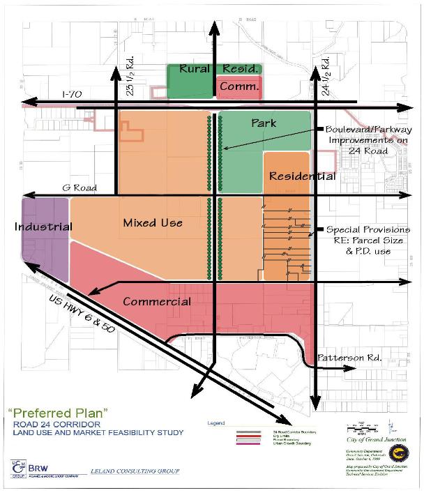
Figure ES-2: “Preferred Plan”
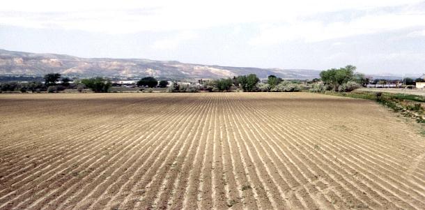
Existing agricultural lands west of 24 Road
(Res. 109-00, 11-1-00)
33.04.060 Implementation of the Subarea Plan.
(a) The Steering Committee discussed how the Subarea Plan could be implemented, through both public and private means. These options fall into the general areas of policies, programs and capital investments.
(1) Implement 24 Road Improvements. Expand to five-lane parkway, with landscaped median, as soon as possible in order to meet transportation requirements as well as “set the tone” in the area for high-quality development.
(2) Adopt a Subarea Plan. Incorporate the recommendations of the Steering Committee into the Grand Junction Growth Plan by adopting a Subarea Plan for the 24 Road Corridor Subarea.
(3) Create a Mixed Use Zone for the Area. Current Grand Junction regulations provide for several planned development zones; however, they may not contain sufficient criteria to achieve the vision for 24 Road Corridor. A new mixed use zone could address issues and opportunities specific to the 24 Road Corridor.
(4) Adopt Design Standards and Guidelines. Develop design standards and guidelines to address the design and planning issues related to commercial development as well as larger land use, open space and transportation framework issues in the corridor.
(5) Develop a Secondary Road Network Master Plan. Establish the location, type and character of secondary roads within the project area, including key access points and interconnections.
(b) In addition, the Steering Committee discussed two other potential options:
(1) The establishment of a public/private entity to provide for cost-sharing of “public” improvements, i.e., two additional lanes on 24 Road, boulevard landscaping, Leach Creek recreational improvements, a possible golf course, and gateway/entry designs.
(2) The potential to create an organization to represent property owners and plan, implement and maintain desired area improvements. This would “institutionalize” private sector involvement and create the means for agreement/cooperation among private sector interests and with the public sector.
Although landowners support the five elements described in subsection (a) of this section, including the concept of more rigorous design standards than the City has in place today, it remains to be seen whether they are willing to step forward to participate financially in exchange for more flexibility in land use and site design through the planned development (PD) process. The potential for cost-sharing between the City and landowners for improvements to a five-lane 24 Road was discussed, with no resolution at this time.
(Res. 109-00, 11-1-00)
33.04.070 Introduction.
The 24 Road Corridor Subarea Plan (the “Subarea Plan”) has been developed to articulate a vision, plan and strategy for the future use and development of the project area, which comprises approximately 1,000 acres in the vicinity of 24 Road between Interstate 70 and the Mesa Regional Mall on Patterson Road. The Subarea Plan is intended to assist the City of Grand Junction, utility and service providers, and property owners in the project area as they plan for the future use and development of the area, including important infrastructure investments that will be necessary to serve future development.
Impetus for the Corridor Subarea Plan was initiated by the City to refine the concepts in the 1996 City of Grand Junction Growth Plan and the different perspectives for development represented by the Growth Plan, property owners, and the community.
This report presents the resulting conclusions and implementation of the four-month planning effort, which included:
(a) An extensive public participation program involving property owners in the corridor, as well as others in the community.
(b) A market study of existing and future supply and demand for commercial and residential development for the entire urbanized area.
(c) An analysis of available commercial lands within the urbanized area.
(d) An analysis of environmental conditions within the corridor.
(e) An analysis of infrastructure availability and capacity within the corridor.
(f) Development of alternative land use plans for the corridor.
(g) Evaluation of the alternatives.
(h) Selection of a preferred plan.
(i) Recommended implementation actions.
Existing agricultural land in the 24 Road Corridor Subarea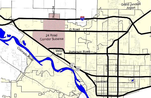
Figure 1: General Location Map
(Res. 109-00 § 1, 11-1-00)