


Chapter 33.20
PLANNING ALTERNATIVES
Sections:
33.20.010 Planning alternatives.
33.20.020 Workshop compilation plan.
33.20.030 Consultant-developed concept plans.
33.20.010 Planning alternatives.
This chapter presents alternative concepts for the future development of the 24 Road Corridor which was discussed by the Steering Committee. These concepts incorporate various approaches to allocating land uses within the corridor and are depicted graphically as well as in narrative. They include a Workshop Compilation Plan and Concept Plans 1, 2, and 3, which were developed by the consultant team. These concepts were then used as a starting point for the “Preferred Plan” presented in Chapter 33.24 GJMC.
The purpose of creating several different land use and circulation options is to evaluate how the spatial relationships of land use and circulation patterns relate to the community’s goals and objectives. Each of the development options or scenarios will rely upon the application of the opportunities and constraints (to land development) as identified in the discussion of existing conditions in Section 4. The variable between each of the proposed alternatives is the spatial location of land uses, size (acreage), intensity of use, open space, and circulation patterns.
The land use categories in Table 12 were used in the formulation of the different concepts. They generally correspond to the land use categories in the 1995 Grand Junction Growth Plan, but are more generalized.
|
Category: Growth Plan Land Use Concepts |
Description |
Concept Alternative Land Use Categories |
|
Commercial |
Wide range of commercial development – no outdoor storage. May allow mixed commercial and residential developments in some cases. |
Retail/Commercial |
|
Commercial Industrial |
Heavy commercial, offices and light industrial uses – no outdoor operations. Some yard operations, provided they are screened. No residential uses. |
Employment |
|
Industrial |
Heavy commercial and industrial operations – includes batch plants and manufacturing operations. No residential uses. |
Industrial |
|
Park |
Active park and recreational sites with significant public access – public or private ownership. |
Park |
|
Residential: Estate |
Single-family homes – two- to five-acre lots. |
Estate |
|
Residential: Low-Density |
Single-family – lots from one-half to two acres. Generally have water and sewer. |
Residential |
|
Residential: Medium- to Low-Density |
Two to four units/acre – urban services. |
Residential |
|
Residential: Medium-Density |
Mix of residential units less than eight units/acre – urban services. |
Residential |
|
Residential: Medium- to High-Density |
Mix of residential units less than 12 units/acre – urban services. |
Residential |
|
Residential: High-Density |
Mix of residential units – between 12 and 24 units/acre – with urban services. Higher density may be allowed if compatible. |
Residential |
(Res. 109-00 § 5, 11-1-00)
33.20.020 Workshop compilation plan.
During the fourth Steering Committee workshop, participants including property owners and their representatives took part in an exercise to develop land use plans and visions for the study area. Divided into five small groups, each group developed a land use plan for the area; these five plans were compiled into one plan representing the concepts of the group.
The land use concept that resulted, referred to as the Workshop Compilation Plan (Figure 6), featured an expansion of commercial uses along Highway 6/50 and a commercial node at the 24 Road/Interstate 70 interchange to take advantage of the access and visibility from these roadways. The most significant element of this proposal is the designation of land adjacent to 24 Road as “employment.” This land use designation, which would include office uses, research and development, might take the form of either office and/or a combination of manufacturing and office uses in a campus setting. Hotels and service uses, restaurants, and convenience retail uses might also be included.
A major concept inherent in the Workshop Compilation Plan is to maintain flexibility to respond to the trends of the market place.
(a) Advantages.
(1) Provides for commercial uses where market forces have traditionally demanded such uses.
(2) “Employment” land use designation allows flexibility and is reflective of the mix of office, research, and assembly operations occurring in many parts of the country.
(b) Disadvantages.
(1) Provides more commercially zoned land than market will support, possibly leading to lower quality development because of over-supply.
(2) Flexibility requires more discretion in the public review process and therefore creates uncertainty for both public and private sectors.
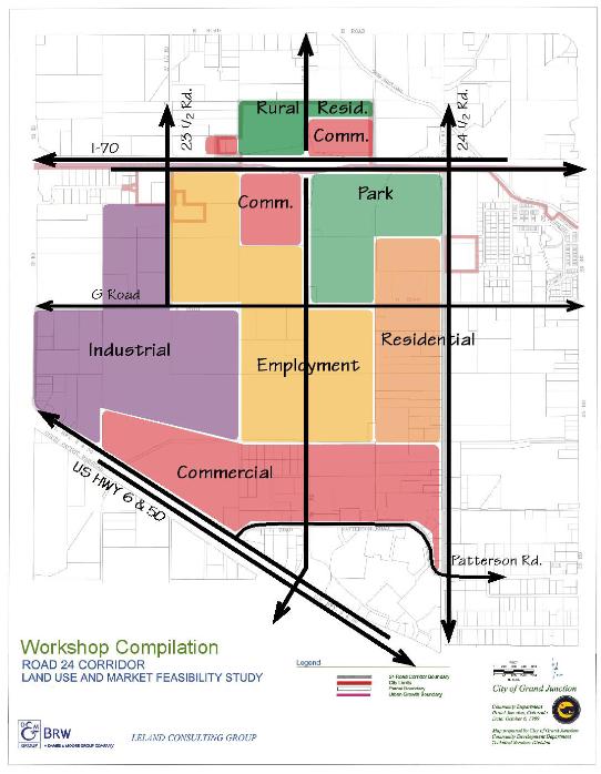
Figure 6: Workshop Compilation Plan
(Res. 109-00 § 5, 11-1-00)
33.20.030 Consultant-developed concept plans.
A common theme for the three concepts developed by the consultant team and discussed by the Steering Committee was to encourage residential, employment, commercial, and industrial uses in the corridor. Several issues underlie the development of Concept Plans 1, 2 and 3:
(a) There is an over-supply of or lack of demand for land, either of which results in low land value.
(b) The community desires to have high quality (design) development occur along the corridor, which is unlikely given the implications of subsection (a) of this section.
(c) The socio-economic characteristics of the community (i.e., current growth being driven primarily by forces related to Grand Junction’s role as a retirement community).
Although the consultants did not examine the market demand for a golf course, each of the three concepts includes the proposed development of approximately 120 acres as a golf course or significant open space amenity. Another sort of recreational activity could also be considered, as long as it serves the graying demographics of Grand Junction. Either way, the recreational amenity was intended to serve as a catalyst for high quality development by increasing the value of land on adjacent properties. In fact, one of several reasons for choosing a golf course is that it would provide positive impact on a wide variety of land use types, such as residential and office uses. The location of the golf course varies from concept to concept, so as not to imply that there is only one preferred location or desire to impact any one particular property owner.
(Res. 109-00 § 5, 11-1-00)
33.20.040 Concept Plan 1.
(a) Concept. The overall concept provides for residential, employment, commercial, and industrial uses in the corridor, including development of 120 acres as a golf course/amenity. Concept Plan 1 illustrates the golf course east of 24 Road. Employment uses are shown west of 24 Road and residential uses to the east and north of the golf course. Commercial is shown along Highway 6/50, with industrial to the west. Concept Plan 1 is illustrated in Figure 7.
(b) Commercial. Commercial nodal development is shown at the 24 Road/I-70 interchange and at the G and 24 Road intersection. Expansion of the existing commercial uses along and adjacent to U.S. Highway 6/50 is also shown. This area is intended to provide sites for large discount retailers (big-box/category killers) that are prevalent today. The G and 24 Road intersection commercial node is intended to provide neighborhood-oriented retail uses. Commercial development at the I-70 and 24 Road interchange is intended for the interstate traveler and regional market.
(c) Rural Residential. Rural residential land north of I-70 is consistent with the Growth Plan.
(d) Residential. Development density is not specified. Residential areas which wrap around land proposed for the golf course may vary from single-family to moderate-density multifamily development.
(e) Park/Recreation. Concept Plan 1 provides for the use of Leach Creek as a trail corridor linking Canyon View Park and the Colorado River Trail, and accents natural features within the golf course.
(f) Employment. Employment zones in this plan are intended to provide the opportunity for office, industrial flex-space and light industrial development with limited retail and residential uses.
(g) Industrial. Industrial areas are illustrated as an extension of the existing industrial area south and east of the U.S. Highway 6/50 and I-70 interchange.
(h) Advantages.
(1) Allows logical expansion of large-scale commercial users adjacent to the highway, providing access and visibility with minimal impacts.
(2) Creates a regional and site amenity (golf course) which increases land value and creates a “signature” image for the area.
(i) Disadvantages.
(1) Market demand for all uses is weak and the market for a golf facility may not exist.
(2) The commercial node at the interchange may draw demand from other less well-served areas of the City. If commercial development occurs at this location first, land values may not satisfy the community’s desire for high-quality development along other areas of the corridor.
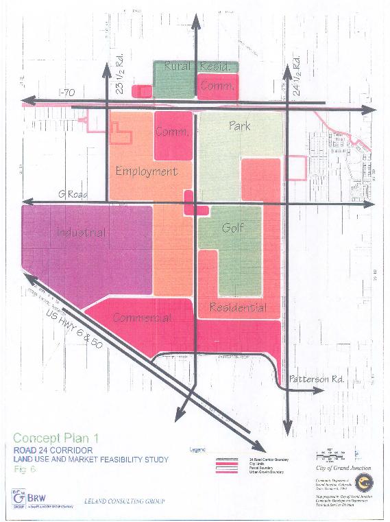
Figure 7: Concept Plan 1
(Res. 109-00 § 5, 11-1-00)
33.20.050 Concept Plan 2.
(a) Concept. The overall concept provides for residential, employment, commercial, and industrial uses in the corridor, including development of 120 acres as a golf course/amenity. Concept Plan 2 illustrates the golf course west of 24 Road. Employment uses are shown east of 24 Road and residential uses to the west and north of the golf course. Concept Plan 2 is illustrated in Figure 8.
(b) Key Elements.
(1) Commercial. Land along U.S. Highway 6/50 is suggested for commercial (big-box) development. Additional commercial uses are proposed for the south side of G Road and east and west of the 24 Road intersection as well as at the 24 Road and I-70 interchange.
(2) Employment. Employment uses include office, office warehouse, and light industrial uses. Three areas are proposed for employment use: in the southeast quarter of the G Road and 24 Road intersection; one-half mile west of the 24 Road and I-70 interchange; and between G Road and U.S. Highway 6/50, approximately one-half mile west of 24 Road.
(3) Residential. Residential use is illustrated along 24 1/2 Road, between the Mesa Mall area and the regional park, adjacent to existing residential use. Additional residential development is proposed west of 24 Road, north and south of G Road. The latter area is shown to wrap the proposed golf course. Development density is not specified.
(4) Rural Residential. Rural residential land is shown north of I-70, consistent with the Growth Plan.
(5) Industrial. Industrial zoning is illustrated as an extension of the existing industrial area south and east of the U.S. Highway 6/50 and I-70 interchange.
(c) Advantages.
(1) Allows logical expansion of large-scale commercial users adjacent to the highway, providing access and visibility with minimal impacts.
(2) Creates a regional and site amenity (golf course) which increases land value and creates a “signature” image for the area.
(d) Disadvantages.
(1) Market demand for all uses is weak and the market for a golf facility may not exist.
(2) The commercial node at the interchange may draw demand from other less well-served areas of the City. If commercial development occurs at this location first, land values may not satisfy the community’s desire for high-quality development.
(3) The location of residential uses adjacent to the golf course does not benefit from synergism of adjacency to other residential development along 24 1/2 Road.
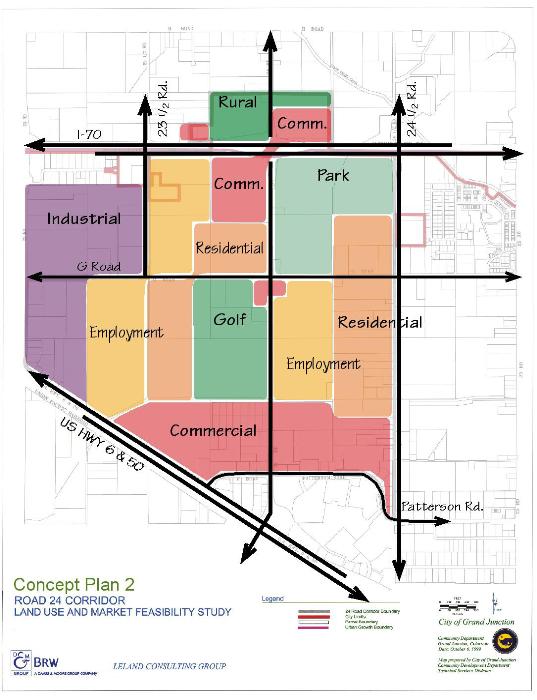
Figure 8: Concept Plan 2
(Res. 109-00 § 5, 11-1-00)
33.20.060 Concept Plan 3.
(a) Concept. The overall concept of Plan 3 is to encourage residential, employment, commercial, and industrial uses in the corridor, including development of 120 acres as a golf course/amenity. This will serve as a catalyst for high-quality residential and employment development. Concept Plan 3 shows the golf course west of 24 Road and north and south of G Road and is illustrated in Figure 9.
(b) Key Elements.
(1) Commercial. Commercial use is illustrated in three locations: at the northeast corner of the I‑70 interchange, at the southeast corner of the G/24 Road intersection, and as expansion along U.S. Highway 6/50.
(2) Industrial. The industrial area south of I-70 will be allowed to expand into the western portion of the study area.
(3) Residential. There are two areas designated for residential use in this concept. One of the areas is located along 24 1/2 Road from the regional park on the north to the commercial area north of Mesa Mall on the south. The second area is located adjacent to the western and southern edges of the golf course.
(4) Employment. Employment uses include office, office warehouse, and light industrial uses. Three areas proposed for employment use: in the southeast quarter of the G Road and 24 Road intersection encircled by the golf course, one-half mile west of the 24 Road and I-70 interchange, and between G Road and U.S. Highway 6/50, approximately one-half mile west of 24 Road.
(5) Rural Residential. Rural residential land north of I-70 is consistent with the Growth Plan.
(c) Advantages.
(1) Allows logical expansion of large-scale commercial users adjacent to the highway, providing access and visibility with minimal impacts.
(2) Creates a regional and site amenity (golf course) which increases land value and creates a “signature” image for the area.
(d) Disadvantages.
(1) Market demand for all uses is weak and the market for a golf facility may not exist.
(2) The commercial node at the interchange may draw demand from other less well-served areas of the City. If commercial development occurs at this location first, land values may not satisfy the community’s desire for high-quality development.
(3) The location of residential uses adjacent to the golf course does not benefit from synergism of adjacency to other residential development along 24 1/2 Road.
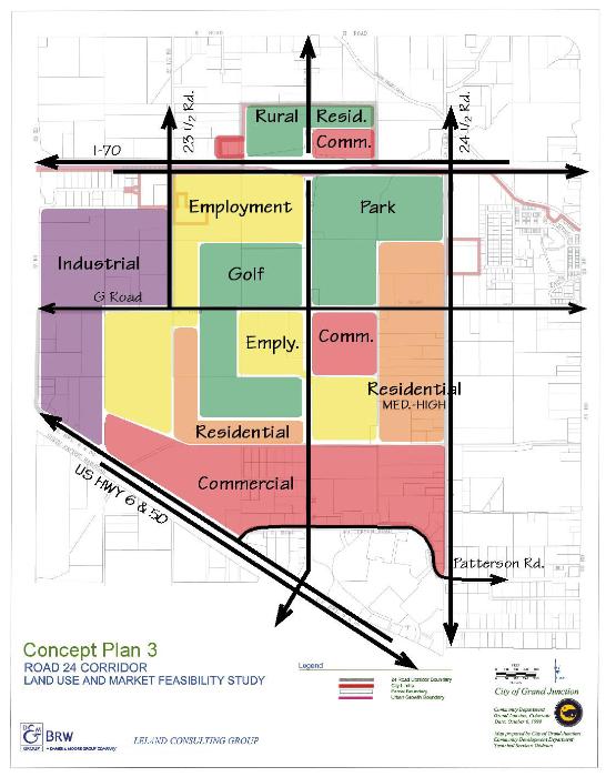
Figure 9: Concept Plan 3
(Res. 109-00 § 5, 11-1-00)