


Chapter 34.20
LAND USE/GROWTH MANAGEMENT ACTION PLAN
Sections:
34.20.010 Findings – Current land use summary.
34.20.030 Agriculture – Goals, policies, implementation.
34.20.040 Future land use and zoning.
34.20.050 Persigo Wash agreement.
34.20.060 Persigo Wash agreement – Goals, policies, implementation.
34.20.070 Neighborhood shopping centers and neighborhood convenience centers.
34.20.090 Buffer area – Community separator.
34.20.100 Buffer area – Community separator – Goals, policies, implementation.
34.20.110 Colorado National Monument.
34.20.120 Colorado National Monument – Goals, policies, implementation.
34.20.130 Environmental resources – Paleontological resources.
34.20.140 Environmental resources – Paleontological resources – Goals, policies, implementation.
34.20.170 Geologic hazards – Goals, policies, implementation.
34.20.190 Mineral resources – Goals, policies, implementation.
34.20.200 Stormwater management.
34.20.210 Stormwater management – Goals, policies, implementation.
34.20.230 Rivers/floodplains – Goals, policies, implementation.
34.20.250 Wetlands – Goals, policies, implementation.
34.20.270 Wildlife – Goals, policies, implementation.
34.20.290 Weed management – Goals, policies, implementation.
34.20.310 Wildfire – Goals, policies, implementation.
34.20.010 Findings – Current land use summary.
The Redlands Planning Area consists of a diverse mixture of land use, management, and ownership. An evaluation of the Mesa County Assessor’s records reveal that agriculture, business, commercial, conservation, industrial, public/quasi-public, residential, and tourist land uses are widely distributed throughout the planning area (Figure 3). As of December 2001, there were approximately 6,686 tax parcels within the planning area. About 72.2 percent of the area is private and 27.8 percent is public or quasi-public. Residential land use is the most prevalent use in the planning area; it comprises about 46 percent of the area.
Lands with a primarily agricultural land use make up about 13 percent of the planning area. The uses include: lifestyle agriculture, orchards, pastures, roadside fruit stands, nursery, and some grazing (limited) on the west end of the planning area. The Redlands Water and Power Company supplies irrigation water to agricultural and residential properties.
More than one-half of the property taxed as agriculture lies in a district that is zoned for residential use. About 30 parcels on 295 acres lie in a zone that permits a density of two units per acre (Residential Single-Family 2 [RSF-2]). Another 25 parcels – 1,453 acres – lie in a zone district that allows a density up to four units per acre (Residential Single-Family 4 [RSF-4]). As the area continues to develop, existing agricultural uses will experience increased conflicts with suburban residential lifestyles.
Business, commercial, industrial, and tourist land uses make up a small percent of the planning area – about two percent. The Redlands area is generally considered a bedroom community for the City of Grand Junction and contains little local employment. The largest employers in the area are Safeway, the schools, Albertson’s, and Pepsi Bottling Company. There are, however, several small neighborhood retail businesses, generally located along Highway 340. They include a bank, convenience stores with gas stations, restaurants, mini-storage, water bottling, and a landscaping and nursery business. The potential for expanded commercial uses exists at the Redlands Marketplace, Monument Village, and neighborhood convenience centers. Industrial uses within the area are limited to gravel pits along the floodplains and terraces of the Colorado River.
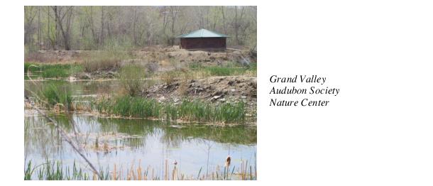
There are numerous public/quasi-public/conservation lands within the planning area. These land uses account for a relatively large portion – 28 percent – of the planning area. Schools in the planning area include: Broadway, Scenic, and Wingate Elementaries; and Redlands Middle School. There are numerous churches throughout the planning area. City, County, and State agencies own/manage parks within the planning area. Parks range from passive recreation and open space (Grand Valley Audubon Society property, Connected Lakes State Park) to active recreation with playgrounds. There are two golf courses in the area – Tiara Rado and Redlands Mesa. Numerous trails and trail connections exist within the planning area. In 1997, Mesa County and the City of Grand Junction adopted the Urban Trails Master Plan (now the Grand Junction Circulation Plan) as an updated plan of all pedestrian and bicycle routes in the Multi-Modal Transportation Study which includes the Redlands Area. Routes depicted on the Urban Trails Master Plan (now Grand Junction Circulation Plan) represent a concept of getting from one point to another, rather than the exact position of each route. The Bureau of Land Management and National Park Service manage lands within or adjacent to the planning area. The Redlands Power and Water Company operates a private water distribution system and hydro power plant.
Residential uses include condos, duplex/triplex, multifamily, and townhomes. Of the 6,686 parcels, 5,142 had structures assessed at $10,000 or more with at least one bathroom on the first floor (a housing unit), (according to the Mesa County Assessor’s records). The average tax parcel size (public and private) in the study area is about 2.5 acres (vacant tax parcels average 9.7 acres); and tax parcels with residential improvements average 1.4 acres. (Table 2, below) (Figure 3)
|
|
# of Parcels/Units |
Total # of Acres |
% of Planning Area |
Max. Size |
Min. Size |
Mean Size |
Structures Over $10K |
|
|---|---|---|---|---|---|---|---|---|
|
Plan Area Summary |
6,686 |
17,039 |
100% |
919 (BLM) |
.05 |
2.5 |
5,209 |
|
|
Agriculture |
82 |
2,291 |
13.4% |
558 |
.5 |
28 |
35 |
|
|
Exempt |
145 |
4,748 |
27.8% |
893 |
.05 |
32.6 |
– |
|
|
Commercial |
56 |
369 |
2.1% |
87 |
.23 |
6.6 |
32 |
|
|
Industrial |
1 |
65 |
0.38% |
65 |
– |
– |
– |
|
|
Residential |
5,821 |
8,203 |
34.1% |
192 |
.05 |
1.4 |
5,142 |
|
|
|
Condo |
155 |
4.5 |
0.026% |
– |
– |
– |
– |
|
Duplex/Triplex |
74 |
53 |
0.31% |
– |
– |
– |
– |
|
|
Multifamily 4-8 |
4 |
1.3 |
0.007% |
– |
– |
– |
– |
|
|
Multifamily 9+ |
1 |
0.61 |
0.003% |
– |
– |
– |
– |
|
|
Townhouse |
227 |
16 |
0.09% |
– |
– |
– |
– |
|
|
No Information |
120 |
1,288 |
7.6% |
– |
– |
– |
– |
|
Source: Mesa County Assessor – 2001.
(Res. 62-02, 6-26-02)
34.20.020 Agriculture.
Agricultural land uses make up about 13 percent of the planning area, and include lifestyle agriculture, orchards, pastures, roadside fruit stands, nursery, vineyards and some grazing (limited) on the west end of the planning area. While it is widely accepted that market economics have a large negative influence on agriculture operators and their willingness/ability to continue operations, the stresses and impacts created from urban influences also have a significant negative impact on agricultural operations (traffic, domestic pets, trespass, improper management of irrigation/tailwater and others). Fragmentation of land uses further complicates the viability of continuing traditional agriculture.
(Res. 62-02, 6-26-02)
34.20.030 Agriculture – Goals, policies, implementation.
(a) Goals.
(1) Encourage residential development patterns that preserve agricultural land, open space, sensitive natural areas, and the rural character.
(2) Promote the use of land conservation tools and techniques that will protect agricultural land.
(3) Encourage residential development on land that is unsuitable for agriculture and require sufficient buffering adjacent to prime agricultural land.
(4) Conserve productive agricultural farmland designated prime per the Natural Resource Conservation Service.
(5) Minimize conflicts between residential and agricultural uses.
(6) Support local agricultural operations and products.
(7) Protect irrigation water/infrastructure for future agricultural use.
(b) Policies.
(1) New development is encouraged to locate on land least suitable for productive agricultural use (productive land in this area may include lands with dry land grazing having a history of grazing use).
(2) Appropriate buffering of new developments is required adjacent to agricultural operations.
(3) New development proposals which may result in conflicts with wildlife and/or agricultural uses will require consultation with the appropriate land and resource manager (e.g., Colorado Division of Wildlife – CDOW, Bureau of Land Management – BLM) and area residents to minimize and mitigate such conflicts.
(4) Support farmers’ markets and promote the purchase of local goods.
(5) Support and encourage voluntary techniques to preserve agricultural lands.
(6) Promote multiple/compatible uses of agricultural lands.
(7) Approve rezone requests only if compatible with existing land use and consistent with the Future Land Use Map.
(c) Implementation.
(1) Provide, to new subdivisions, model homeowners’ association conditions, covenants, and restrictions that address agricultural protection efforts (control of domestic pets, setbacks, etc.).
(2) Utilize the Mesa County Technical Resource Advisory Committee to share agricultural preservation options for landowners.
(3) The County shall enforce the Mesa County Right to Farm and Ranch Policy by use of the Agricultural Advisory Panel to mediate conflicts.
(4) The County will continue to distribute the Code of the New West.
(Res. 62-02, 6-26-02)
34.20.040 Future land use and zoning.
The Redlands area is a joint planning area of Mesa County, the City of Grand Junction, and the City of Fruita. Much of the planning area is located within the joint urban planning area as depicted in the Mesa Countywide Land Use Plan and the Grand Junction Growth Plan. (The western portion of the planning area includes the GJ/Fruita/Mesa County Cooperative Planning Area (buffer or community separator) and the City of Fruita’s Community Planning area (three-mile radius from City limits). The area within the joint urban planning area has a more detailed land use classification system than the more rural areas of Mesa County because of the more intense urban pressures it experiences. The planning area has 16 future land use classifications. The City’s and County’s development codes implement these classifications. The City’s and County’s zoning districts are used to establish the conditions for the use and development of land in each of the future land use categories. Lands that lie within the Redlands Planning Area and within the joint urban planning area of the City and County use the same Future Land Use Map for reference. However, the City’s interpretation of the map has a regulatory effect, while the County’s interpretation of the map has an advisory effect.
Most of the future land use classifications in the planning area are not being changed from their current classifications. Some changes are being made because of inconsistencies with existing uses or zoning map conflicts. The following areas require changes to the Future Land Use Map. See Future Land Use Map Inconsistencies (Figure 4).
(a) Scenic Area. Area currently has 362 parcels shown as Residential Low (lots size between one-half acre and two acres) and four parcels shown as Conservation. Changed this area to Residential Medium-Low (with densities between two and 3.9 units per acre), to more accurately reflect existing lot sizes and development trends in the area.
(b) Rio Hondo Drive Area. Area currently has 10 parcels along the east side of Rio Hondo Drive shown as Residential Medium (with densities between four and 7.9 units per acre).
Changed to Residential Medium-Low (with densities between two and 3.9 units per acre), to more accurately reflect existing development pattern in the area.
(c) Connected Lakes Area. Currently eight parcels located on the north side of Dike Road near the Colorado State Park were shown as Public and changed to Residential Low (with lot size between one-half acre and two acres). Also:
(1) Grand Valley Audubon Property – four parcels changed from Park, Public and Residential Low to Conservation.
(2) Whitewater Building Materials Property – two parcels from Public to Rural and one parcel from Residential Low to Rural.
(3) Colorado River Area – one parcel and the river portion of another parcel from Commercial to Conservation and one parcel changed from Park to Conservation.
(d) Monument Village Shopping Center Area. Corrected to reflect the approved commercial and residential uses. One parcel currently shown as Residential Medium (with densities between four and 7.9 units per acre) changed to Commercial. This parcel is approved for commercial uses by Mesa County.
Two parcels shown as Commercial changed to Residential Medium (with densities between four and 7.9 units per acre). These two residential parcels are part of the Monument Village Subdivision.
(e) Peony Drive Area. Twenty-four residential parcels on north end of subdivision were shown as Park and changed to Residential Medium-Low (with densities between two and 3.9 units per acre).
Changed from Park to Conservation for four parcels that largely encompass hillside and riverbank areas along river bluff.
(f) Areas Shown as Conservation Areas on Map. Parcels of land that are designated as Conservation are generally properties that have limited development potential due to one or more of the following issues: floodplain, steep slopes, wetlands or major drainage issues. Properties that have such constraints with little buildable area are shown as conservation on the Future Land Use Map. Several properties previously shown as Conservation were identified as being in error and should be designated the same land use classification as other adjacent properties. These properties include:
(1) One parcel located at 2067 E 1/2 Road from Conservation to Estate (Lots = two to five acres).
(2) Two parcels located at 120 Mesa Grande Drive and 2336 S. Broadway respectively from Conservation to Residential Low (lots = one-half to two acres).
(3) One parcel located at 2525 D Road from Conservation to Residential Medium-Low (two to four dwelling units per acre).
(g) Other Errors on Existing Future Land Use Map. A commercial business property at 2245 3/4 Broadway changed to Commercial, that was shown as Public.
A single-family residence at 2458 Broadway which was shown as Water changed to be the same as surrounding properties shown as Residential Low (lots size between one-half acre and two acres).
Property at 363 South Redlands Road changed from Estate to Residential Low and 379 South Redlands Road changed from Residential Medium to Residential Low.
(h) Fruita/Grand Junction/Mesa County Buffer Area. Designation as “Cooperative Planning Area (Community Separator)” to fully implement the intergovernmental agreement between Mesa County, City of Fruita and the City of Grand Junction.
(i) Public Properties to the Land Use Category of Public. All properties that are owned by “tax supported” public entities are shown as public on the Future Land Use Map with the exceptions as noted below. These include property owned by the following public entities:
(1) BLM;
(2) Bureau of Reclamation;
(3) Colorado National Monument;
(4) Mesa County;
(5) School District 51;
(6) Ute Water;
(7) City of Grand Junction (except existing or future park sites which will be designated as Park).
(j) Churches to Same Designation as Adjacent Residential Properties. There are four churches on the Redlands that were previously shown as Public. They changed from Public (see subsection (i) of this section) to the same land use category as adjacent properties which for all four properties is Residential Medium-Low.
(1) Redlands United Methodist Church at 527 Village Way.
(2) Liberty Baptist Church at 405 South Camp Road.
(3) Church on the Rock at 2170 Broadway.
(4) Monument Baptist Church at 486 23 Road.
Future Land Use Map Inconsistencies (PDF)
(k) Swan Lane Area. This neighborhood has 58 properties with 39 of them less than one-half acre in size. The area is bounded by Mockingbird Lane on the west, Highway 340 on the north, Reed Mesa Drive and 22 1/4 Road on the east, and Mudgett Avenue on the south. The 39 parcels are nonconforming to the Land Use category of “Residential Low.” Changing the Future Land Use Map to “Residential Medium-Low” will bring all properties into compliance with the Future Land Use Map and bring the area into conformance with Mesa County Zoning of Residential Single-Family with a maximum density of four units per acre (RSF-4).
Zoning in the planning area contains both unincorporated Mesa County land and areas within the City limits of Grand Junction. Land that is unincorporated Mesa County is zoned and regulated by the County, while land that is within the municipal boundaries of the City of Grand Junction is zoned and regulated by the City. The two governments have agreed to work together to create an orderly transition from County to City.
(Res. 62-02, 6-26-02)
34.20.050 Persigo Wash agreement.
The 1998 Intergovernmental Agreement between the City of Grand Junction and Mesa County relating to City growth and joint policy making for the Persigo Sewer System (the Persigo Agreement) affects land use and development in the area. Pursuant to the Persigo Agreement, certain new development within the Persigo 201 Sewer Service Area (which is the same as the urban growth boundary) must annex to the City of Grand Junction. Provision of sewer service does not automatically require annexation. Existing residential development connecting to sewer is not required to annex nor provide a power of attorney (POA) for annexation in the future. (Figures 5A and 5B)
(Res. 62-02, 6-26-02)
34.20.060 Persigo Wash agreement – Goals, policies, implementation.
(a) Goals.
(1) New development will pay its fair, equitable, and proportionate share of the cost of providing necessary services, utilities, and facilities at the applicable service levels.
(b) Policies.
(1) The City and County will use the Future Land Use Plan Map in conjunction with other policies to guide new development decisions. (Figures 5A and 5B)
(2) Urban land uses will be encouraged to occur in municipalities and not outside municipal limits.
(3) The City and County will place different priorities on growth, depending on where proposed growth is located within the joint planning area, as shown in the Future Land Use Map (Figures 5A and 5B). The City and County will limit urban development1 in the joint planning area to locations within the urbanizing area with adequate public facilities as defined in the City and County codes.
(c) Implementation.
(1) With voluntary bulk rezones to AF35, AFT, RSF-R, or RSF-E consistent with the plan. The County will initiate and assist property owners with voluntary bulk rezones to AF35 where consistent with the Plan.
(2) The City shall zone annexed properties consistent with this Plan.
(Res. 62-02, 6-26-02)
34.20.070 Neighborhood shopping centers and neighborhood convenience centers.
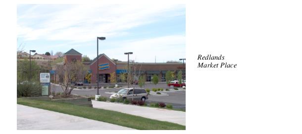
(a) Neighborhood Shopping Centers. Neighborhood shopping centers are sites of 10 to 15 acres, designed to meet consumer needs from adjacent neighborhoods. Uses usually include a supermarket with associated mixed retail and personal services. These centers might also include employment uses, such as office. Examples of neighborhood shopping centers on the Redlands are Monument Village Shopping Center, with Safeway as the anchor, and Redlands Marketplace, with Albertson’s as the anchor.
Monument Village Shopping Center and surrounding commercial property, located on Highway 340 and Monument Village Drive, consists of approximately 12 acres. Five acres are developed with approximately 45,000 square feet of retail, including a grocery store, liquor store, restaurant and gas station/convenience store. The remaining seven acres could develop as additional retail, or, more likely, office and service uses.
Redlands Marketplace, located on Highway 340 and Power Road, consists of approximately 10 acres with 66,000 square feet of retail, including a grocery store, liquor store, video store, packing and shipping outlet and beauty salon. There is another 20,000 square feet of retail planned for the site. The area also includes substantial commercial development on the remaining three corners of the intersection with the possibility for new development and redevelopment.
These two neighborhood shopping center areas on the Redlands are well located and will serve the needs of the Redlands into the foreseeable future.
(b) Neighborhood Convenience Centers. Neighborhood convenience centers are sites of eight acres or less, with four or more business establishments located in a complex that is planned, developed and managed as a unit. Convenience centers are located within and intended to primarily serve the consumer demands of adjacent residential neighborhoods. Uses may include retail, personal services, convenience grocery stores (with accessory gas pumps), restaurants without drive-up windows, liquor sales, beauty or barber shops, dry cleaners, and equipment rental (indoor only). Secondary uses may include professional offices, limited banking services such as automated teller machines, multifamily dwellings, medical offices and clinics, small animal veterinary clinics and child care centers.
The existing convenience centers on the Redlands are Meadowlark Gardens and Country Corner, located on Highway 340 and South Broadway, and the office service area of the Ridges, located on Ridges Boulevard and Ridge Circle Drive.
The Meadowlark Gardens development consists of five acres with 20,000 square feet developed as a bank and nursery and 23,000 square feet of future office/retail space. Country Corner includes 1.3 acres developed with 17,000 square feet of office/retail and just under an acre remaining for additional development. The Ridges commercial area consists of two acres with 14,000 square feet of office and service space, and very little area for additional commercial development.
There are two other sites on the Redlands recommended for future neighborhood convenience development. Those are the Seasons, on South Broadway, and the 23 Road area south of Highway 340. (Figure 6)
The “Beach” property, adjacent to the Seasons development, currently includes a clubhouse building of 8,500 square feet, a swimming pool, tennis courts and volleyball courts, as well as a parking lot. The property would be appropriate for a recreation/health club facility that could serve the Redlands area. Adjacent to the Beach property is a large tract of land that has an approval for residential and business uses. A maximum of 12,000 square feet of light business uses, as approved with the annexation of the Seasons development, would be appropriate. Development of this property should be in character, in terms of scale and architecture, with the surrounding residential development.
Likewise, neighborhood convenience uses may be appropriately integrated into future development of the 23 Road south area. Such commercial uses should be located on the north end nearer the South Camp and South Broadway corridors to benefit the existing development in the South Camp areas, as well as new development.
It is not anticipated that additional convenience centers will be needed on the Redlands to serve the projected population. (Figure 6)
(Res. 62-02, 6-26-02)
34.20.080 Neighborhood shopping centers and neighborhood convenience centers – Goals, policies, implementation.
(a) Goals.
(1) Support the long-term vitality of existing neighborhood shopping centers and existing and proposed neighborhood convenience centers.
(2) To enhance the ability of neighborhood centers to compatibly serve the neighborhoods in which they are located.
(b) Policies.
(1) The City and County will limit commercial encroachment into stable residential neighborhoods. No new commercial development will be allowed in areas designated for residential development unless it has been identified as a neighborhood shopping center or neighborhood convenience center by this Plan.
(2) The City and County will encourage the retention of small-scale neighborhood commercial centers that provide retail and service opportunities in a manner that is compatible with surrounding neighborhoods.
(3) The City and County will protect stable residential neighborhoods from encroachment of incompatible residential and nonresidential development.
(c) Implementation.
(1) Rezoning for commercial uses in areas other than those identified in this plan for neighborhood shopping centers and neighborhood convenience shall require a Plan amendment.
(2) Design standards and guidelines shall be established for commercial development on the Redlands.
(Res. 62-02, 6-26-02)
34.20.090 Buffer area – Community separator.
The Mesa County/Fruita/Grand Junction Community Separator (Fruita/GJ buffer) was created in 1998 by an intergovernmental agreement (IGA) among the three entities of Grand Junction, Fruita, and Mesa County. The primary function of the buffer is to maintain distinct communities within Mesa County. It is implemented through a variety of voluntary techniques to ensure a physical separation between the cities of Fruita and Grand Junction. (Figure 7)
Approximately 1,716 acres of the buffer area lie in the Redlands Planning Area. There are 29 parcels taxed as agricultural that account for a total of 1,130 acres with the average parcel size being 47 acres. The number of residential lots in the area total 153 and account for 501.7 acres; the average residential lot size is 3.3 acres. Tax exempt lands account for 85 acres (public and quasi-public land uses).
The buffer landscape is varied and includes: highway corridors, the Colorado River and its floodplain, important agricultural land, wildlife habitat, scenic bluffs and canyons, and a patchwork of rural residential development. The Colorado National Monument abuts the south border of the buffer.
Currently, the three parties to the IGA are actively exploring, developing, and supporting options and seeking funding mechanisms to preserve open lands and enhancing the rural character of the buffer area. A wide variety of implementation tools is being explored to make the buffer agreement successful. The Future Land Use map depicts these IGAs, Persigo, Buffer and Future Land Use Designations. (Figures 5A and 5B)
(Res. 62-02, 6-26-02)
34.20.100 Buffer area – Community separator – Goals, policies, implementation.
(a) Goals.
(1) Preserve and protect the agricultural/rural character of the buffer area.
(2) Promote and implement the intergovernmental agreement (IGA) between Fruita, Grand Junction, and Mesa County.
(3) Approve rezone requests only if compatible with existing land use and consistent with the Future Land Use Map.
(b) Policies.
(1) Seek funds to support the purchase of development rights (PDR) program for the buffer.
(2) Development projects that are proposed in the buffer should be thoroughly evaluated for their individual and cumulative impact to the agriculture and rural character of the area.
(3) PDR and transfer of development rights (TDR) projects should be expanded to protect more agricultural land in the buffer.
(c) Implementation.
(1) The County will assist property owners to voluntarily rezone multiple properties to AFT and RSF-E where consistent with the objectives of the buffer agreement.
(2) Assist area residents with education and implementation of land conservation tools and techniques.
(3) An overlay zone shall be created for the buffer area to include land use standards as well as design guidelines and standards to preserve the rural character that is contained in the buffer area within the planning area.
(Res. 62-02, 6-26-02)
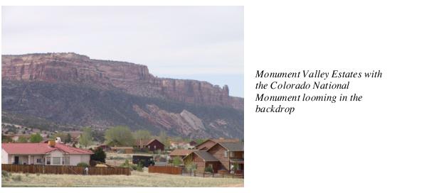
34.20.110 Colorado National Monument.
The Colorado National Monument is a major tourist attraction of the Western Slope and the Grand Junction area. Each year approximately 300,000 people visit the Monument to see its spectacular scenery. Besides being an economic asset to the area, it contains a wealth of vegetation and wildlife resources. Development contiguous or adjacent to the Monument has a direct negative impact to its aesthetics and natural resources. Habitat loss, night lighting, domestic pets, nonnative nondesirable plants, fencing, and subdivision development detrimentally affect the resources of the Monument. Each new development adds to the cumulative impact of previous change. For example, cliff nesting raptors depend on canyon walls of the Monument for perching, roosting, and nest sites. Raptors forage for insects, rodents, and small birds that depend on agricultural fields and upland grasslands in the planning area. As the fields and open lands are converted to urban uses, reductions of available food occur throughout the entire food chain.
The following broad principles (landscape scale) are applicable as new development(s) occurs contiguous or adjacent to the Monument:
(a) Maintain buffers between areas dominated by human activities and core areas of wildlife habitat in the Monument.
(b) Facilitate wildlife movement across areas dominated by human activities.
(c) Control domestic pets associated with human-dominated areas.
(d) Mimic features of the natural landscape in developed areas.
In addition to the broad principles stated above, specific (site scale) efforts are necessary to avoid, minimize and mitigate impacts to the Monument. Such efforts include maintaining/mimicking natural landscape features, maintaining/enhancing movement corridors for wildlife, minimizing contact with domestic pets, avoiding night-time light pollution, and minimizing ridgeline/backdrop visual impacts from development. Area residents and developers have expressed interest in promoting/implementing architectural designs that complement the natural features of the area, including color, texture, materials, scale, and lighting.
The 1986 Redlands Plan states, “Densities along the border of the Colorado National Monument for new developments shall be limited to low density (one dwelling unit per five acres) and no structures except those within the five-acre density range will be allowed within 1,000 feet of the Monument boundary, if property lines of any parcel exceed that setback. (Planned unit developments that have received final approval and platted subdivisions would not be subject to this policy.) This setback area may be counted, however, as part of the open space requirement in a planned unit development and overall densities established as part of a planned unit development may be transferred from this area to other locations within the planned unit development (transfer of development rights).” While this policy has not been fully implemented over time, the policy is sound and should remain in effect for those parcels that do not have structures on them yet.
The City of Fruita also has identified some lands adjacent to the Colorado National Monument as a Monument Preservation District. The Fruita Community Plan 2020 describes the district and its recommended land uses more specifically.
In 1999 Mesa County and the National Park Service entered into a memorandum of understanding (MCA 99-48) that, among other things, requires both parties to share information and opportunities for input on land use and management. (See also Chapter 34.16 GJMC, Community Image/Character Action Plan.)
(Res. 62-02, 6-26-02)
34.20.120 Colorado National Monument – Goals, policies, implementation.
(a) Goals.
(1) Protect the aesthetic and natural resource values of the Monument from the impacts of new development.
(b) Policies.
(1) Minimize, avoid, and/or mitigate the impacts of development to the Monument.
(2) Promote the use of native plants for landscaping new developments adjacent to the Monument and washes coming from the Monument.
(3) Promote landowner and resident awareness about the impacts that domestic pets can have on wildlife.
(4) Densities along the border of the Colorado National Monument for new developments shall be limited to low density (one dwelling unit per five acres) and no structures except those within the five-acre density range will be allowed within 1,000 feet of the Monument boundary, if property lines of any parcel exceed that setback.
(c) Implementation.
(1) Develop night lighting (floodlight) standards within the City’s and County’s development codes for the planning area, to apply to existing and new lighting.
(2) Create and distribute a list of locally available native plant materials that can be used for revegetation and landscaping of new developments.
(3) Distribute information about the Mesa County noxious weed list.
(4) Provide information to the public and homeowners’ associations (HOAs) about proper fencing techniques to protect wildlife (Division of Wildlife fencing pamphlet).
(5) Utilities shall be placed underground for all new development.
(6) Develop gateway aesthetic and architectural guidelines/standards for commercial and residential development for the entryways to the Monument.
(7) Improve signing/trespass problems/issues for both landowners and the Monument in cooperation with public land and resource managers.
(8) Continue to implement the Memorandum of Understanding (MCA 99-48) between the Monument and Mesa County.
(9) Create a Monument setback overlay district incorporating conservation design guidelines and standards.
(Res. 62-02, 6-26-02)
34.20.130 Environmental resources – Paleontological resources.
Paleontological resources are an irreplaceable element of the heritage of Mesa County, Colorado, and the United States. The resources are increasingly endangered because of their commercial attractiveness, ease of accessibility, and their rare or unique value. Paleontological resources are nonrenewable and have important heritage value. They offer significant educational opportunities to all citizens.
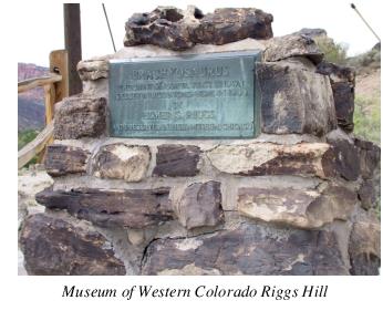 Over 100 years of paleontological work in Mesa County has produced many beautiful, exotic, and scientifically important fossils. The first specimen of Brachiosaurus, found at Riggs Hill in 1901, was taken to the Chicago Field Museum for display. It is still on display today. While the extent and significance of paleontologic resources in the planning area is not fully known, the area around Riggs Hill is recognized for its fossil resources. Other paleontologic sites and resources such as Little Park Road and Dinosaur Hill are located within the planning area and are irreplaceable. A comprehensive inventory of the resources is needed. Every effort shall be made to preserve and protect significant paleontologic resources whenever possible and reasonable. Any development or mineral extraction shall be discouraged in sensitive areas.
Colorado State law identifies the State Archaeologist as the administrator of historical, prehistorical, and archaeological resources in the State. The State Archaeologist is the individual ultimately responsible for permitting, controlling, and enforcing resource exploration and recovery on State, County, City, Town, District, or other political subdivision of the State (C.R.S. § 24-80-401).
(Res. 62-02, 6-26-02)
34.20.140 Environmental resources – Paleontological resources – Goals, policies, implementation.
(a) Goals.
(1) Every effort shall be made to identify and protect paleontologic and prehistoric sites from destruction or harmful alteration.
(b) Policies.
(1) Protect and interpret paleontologic resources of the planning area.
(2) The Museum of Western Colorado shall be a review agency for all land use proposals where a possible impact to a paleontologic/prehistoric or archaeological site has been identified.
(c) Implementation.
(1) Conduct a comprehensive inventory of paleontologic resources in the planning area in conjunction with the Museum of Western Colorado.
(2) Identify properties containing paleontologic resources or other sensitive resources that could be threatened by development or surface mineral extraction/development.
(3) Encourage the Museum of Western Colorado to preserve and interpret sites to promote understanding and appreciation of paleontologic resources.The Mesa County Land Development Code and City of Grand Junction’s Development Code along with applicable regulations shall be updated/amended to ensure that paleontologic, archaeologic, and/or historic resources are protected (paleontological, archaeological, and historical resources shall be preserved as required/determined by the Board or Council).
(Res. 62-02, 6-26-02)
34.20.150 Geologic hazards.
Section 7.6.1 of the Mesa County Land Development Code, 2000 contains the following language about hazard areas: “Land subject to hazardous conditions such as wildfire, land slides, gamma radiation, mud flows, rock falls, snow avalanches, possible mine subsidence, shallow water table, open quarries, floods, and polluted or nonpotable water supply, shall be identified in all applications, and development shall not be permitted in these areas unless the application provides for the avoidance of the particular hazards. If avoidance is impossible or would require the construction to violate other development standards, then such hazards shall be minimized or mitigated. Land subject to severe wind and water erosion shall be identified on all plans and shall not be subdivided unless the problems are mitigated by density limitation or some other practical method.”
Similarly, the City of Grand Junction’s Zoning and Development Code sets forth specific criteria for land use and development activities in areas identified on the Geologic Hazards Map. The criteria is found in GJMC 21.140.100 GJMC.
The planning area contains numerous, and widespread geologic hazards according to Stephen Hart’s 1976 “Geology for Planning in the Redlands Area, Mesa County, Colorado.” Hart’s report depicts and describes the following hazards (Figure 8):
(a) Landslide Deposits. Areas of slope material that show geologic or physiographic evidence of past failure.
(b) Potentially Unstable Slopes. Areas showing evidence of creep or past slope failure.
(c) Rockfalls. Areas susceptible to nearly instantaneous downslope movement of large rock blocks.
(d) Expansive Soil and Rock. Areas underlain by potentially swelling and/or shrinking soil and rock.
(e) Corrosive Soil and Rock. Areas underlain by soil or rock that contains high concentrations of sulfate and/or sodium salts. These salts may produce corrosion of concrete or metal objects (floor slabs, pipes, etc.) in contact with the soil or rock.
(f) Overbank Flooding. Areas along the Colorado River susceptible to overbank flooding and high water table.
(g) Flash Flooding. Areas along minor drainages susceptible to flash flooding. (Note: Not all drainages are mapped and require consultation with the Army Corps of Engineers.)
Due to the extent and diversity of hazards in the planning area, and language in the Mesa County and City of Grand Junction land development codes, every effort should be made to avoid, minimize, and mitigate development in mapped hazard areas. Further, a detailed geologic and engineering investigation should be made at every building site before beginning design or construction.
Investigations shall be performed by a professional geologist pursuant to C.R.S. § 34-1-201(3).
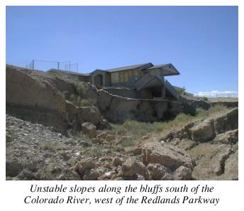
Evidence of residential development built on unstable slopes, soil creep and slumping is easily seen along the bluffs of the Colorado River (south side), west of the Redlands Parkway. Numerous locations along the Colorado River bluffline show signs of soil movement and unstable slopes.
(Res. 62-02, 6-26-02)
34.20.160 Faults.
According to the Mineral Resources Survey of Mesa County (1978), the planning area contains part or all of the following three faults: Kodel Canyon Fault, Redlands Fault, and Jacobs Ladder Fault complex. The faults are primarily located on BLM lands and residents should be aware of their existence and location (Figure 8). Avoidance, minimization, and mitigation are strategies for dealing with development activity in fault areas. Mapping fault locations, zoning for low density development, classifying fault areas as recreation areas, utility corridors, open space, and establishing setbacks are specific tools used to protect individuals and communities from damage that can be caused by faulting and subsequent geologic hazards.
(Res. 62-02, 6-26-02)
34.20.170 Geologic hazards – Goals, policies, implementation.
(a) Goals.
(1) Inappropriate development in hazard areas should be reduced as much as possible or eliminated in order to minimize potential harm to life, health and property.
(2) Efforts to mitigate existing areas at risk to the impacts of natural hazards and disasters should be made to minimize the potential for harm to life, health, and property.
(3) The costs (economic, environmental and social), associated with natural hazards should be reduced by avoiding potential hazard situations/areas; by mitigating activities that cannot be avoided; and by promoting prevention measures accompanied with education and incentives for mitigation.
(b) Policies.
(1) The City and County shall strongly discourage intensive uses in hazard areas as identified on the geologic hazards areas map.
(2) Educate residents of the planning area about the extensive geologic hazards in the area.
(c) Implementation.
(1) Use the geologic hazards map to identify areas of concern and require detailed geologic and engineering reports (evaluation) for each site and development prior to design and development. Such evaluations shall be conducted by either a member of the American Institute of Professional Geologists, a member of the Association of Engineering Geologists, an individual registered as a geologist by a state, or a “professional geologist” as defined in C.R.S. § 34-1-201(3). Such evaluations should incorporate analytical methods representing current, generally accepted, professional principles and practice.
(2) Develop setbacks from mapped geologic hazard areas.
(3) Develop and adopt a hazardous lands overlay district for the Redlands area.
(Res. 62-02, 6-26-02)
34.20.180 Mineral resources.
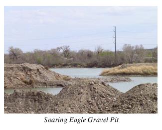
(a) Extraction Policies – Sand and Gravel. New development in unincorporated Mesa County must comply with State law, (C.R.S. § 34-1-301, 1973). The Mesa County Mineral Extraction Policies protect undeveloped, commercially valuable mineral resources from other types of development and require new extraction operations in residential areas to mitigate impacts on existing developments. As the Redlands area continues to develop, the potential for land use conflicts will increase between gravel operations and other development. The current Mesa County Agricultural Policies (Policy No. 17 of the Mesa County Land Use and Development Policies), which encourage the retention of large tracts of prime and unique agricultural lands, are often in conflict with the mineral extraction policies.
According to the Mineral Resources Survey of Mesa County (1978), “gravel deposits of the greatest economic importance in Mesa County lie along the Colorado River between the mouth of the canyon east of Palisade and the point near Loma at which the river enters canyon country of the Uncompahgre Plateau. Only a small portion exposed along the river can be considered economically viable.” (Figure 9)
“Colorado River terrace deposits exist on the Redlands. These deposits are about 12 to 22 feet thick with three to five feet of overburden.” Gravel extraction in the planning area occurs along either side of the river wherever access is available and practical. Bluffs on the south side of the river limit access to many resource sites. Most of the gravel is used for building materials and highway projects.
Mesa County requires a conditional use permit for gravel extraction and processing in the following zone districts: AFT, AF-35, RSF-4, and I-2. Specific criteria for the permit are found in Chapter 5, Section 5.2.13 of the Code.
The City of Grand Junction allows gravel extraction (after obtaining a conditional use permit (CUP)) in the RSFR, I-0, I-1, I-2, and CSR zone districts. The City’s Zoning and Development Code sets forth the specific criteria, which is found in GJMC 21.112.110.
(b) Gas and Oil. The Mineral Resources Survey of Mesa County did not identify or map any gas fields in the planning area. There are no oil wells, and only one gas well was identified in the planning area.
(c) Coal, Claystone, and Shale. Coal deposits are located throughout the planning area in relatively small amounts. Presently there are not any active mine sites in the planning area.
(Res. 62-02, 6-26-02)
34.20.190 Mineral resources – Goals, policies, implementation.
(a) Goals.
(1) Utilize the mineral resources of the planning area while protecting residents of the area from the impacts of mineral/gravel extraction.
(b) Policies.
(1) New development must comply with the Mesa County Mineral Extraction Policies which generally protect and preserve commercially valuable mineral resources from incompatible land uses.
(2) Allow sand and gravel extraction to occur in areas with minimal impact on other uses.
(3) Reclaim gravel pits for agricultural, residential, and/or other approved uses.
(4) Educate the public on mineral extraction policies and location of valuable resources.
(c) Implementation.
(1) Gravel extraction areas along the Colorado River floodplain shall be reclaimed for agricultural, public open space, wildlife areas, or other permitted uses.
(2) Mesa County shall publish and distribute a Mesa County Mineral Resource and Extraction Policy brochure/handout. (Realtor offices, Assessor’s office, etc.).
(3) Gravel operations shall continue to be regulated on a case-by-case basis using the conditional use permit process; however, in developed areas, limited impact mining operations in terms of surface disturbances, tonnages mined, and daily vehicular traffic will be encouraged and should be given preference over higher impact operations.
(Res. 62-02, 6-26-02)
34.20.200 Stormwater management.
(a) The Mesa County Stormwater Management Manual was adopted May 1996 by the Board of County Commissioners (also adopted by the City of Grand Junction in 1994). The purpose of the Mesa County Stormwater Management Manual is to provide standards for sound drainage practices to maintain or enhance quality of life of the public, and protect the public from adverse stormwater effects that could potentially occur due to development. The manual establishes standards for all new development regarding drainage practices. The Grand Junction and Mesa County Public Works Departments administer the Stormwater Management Manual. There is not a drainage district in the Redlands Area.
(b) Drainage/Washes. The 1986 Redlands Plan states that, “washes, stream beds, and water courses shall have a minimum setback of 100 feet from the top elevation of the stream bed.” Recent riparian, wash/drainage studies indicate that buffers can vary from 10 to 300 feet either side of a wash/drainage depending on soil, vegetation, and topographic conditions. Setbacks for washes, stream beds, and water courses should be reevaluated and new setbacks established.
The following mapped drainages and washes provide important values and functions to the residents of the Redlands area and require the use of best management practices and protection (Figure 8): No Thoroughfare, Red Canyon, Limekiln, Goldstar, Ute Canyon/Goat Wash, North Entrance, East Entrance, Lizard, and Fruita Canyon. There are numerous other smaller, unnamed washes that provide important drainage functions and values in the landscape and to the residents of the planning area. All of the prominent washes in the planning area have been impacted by development to some degree. Consultation with the Army Corp of Engineers is required for any new development. (Figure 8)
(Res. 62-02, 6-26-02)
34.20.210 Stormwater management – Goals, policies, implementation.
(a) Goals.
(1) Conserve, protect, or restore the integrity of the values and functions that drainages/washes provide in the Redlands Planning Area.
(b) Policies.
(1) Drainage from development or any alterations to historic drainage patterns shall not increase erosion either on-site or on adjacent properties.
(2) Erosion from development and other land use activities should be minimized, and disturbed or exposed areas should be promptly restored to a stable, natural, and/or vegetated condition using native plants and natural materials.
(3) The City and County shall work toward minimizing human impacts to riparian ecosystems of drainages/washes from development, roads and trails.
(4) Disturbed drainages/washes should be restored to pre-disturbed condition as much as practicable.
(c) Implementation.
(1) Management of riparian/wash/drainage areas shall encourage use or mimicry of natural processes, maintenance or reintroduction of native species, restoration of degraded plant communities, elimination of undesirable exotic species, and minimizing human impacts.
(2) A citizen group shall be established to study and prepare wash/drainage buffer width setbacks and revegetation guidelines for the Redlands Planning Area.
(3) The preferred reclamation/stabilization for drainage/washes is the use of tree stumps, boulders, soil and native vegetation; channelizing or hardenening off with concrete or rip-rap is discouraged. The use of rip-rap should be kept to a minimum.
(Res. 62-02, 6-26-02)
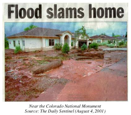
34.20.220 Rivers/floodplains.
The City of Grand Junction and Mesa County Floodplain Regulations are required for City/County residents to be eligible for federal floodplain insurance. The primary goals of the floodplain regulations include:
(a) To help minimize property damage to Mesa County residents during flood events;
(b) To ensure that life, property, or new improvements will be safe during flooding events;
(c) To make sure that any structures or improvements in the floodplain will not cause additional drainage problems;
(d) To protect the natural resource values of floodplain areas;
(e) To guide development in the floodplain of any watercourse subject to flooding; and
(f) To minimize the expense and inconvenience to property owners and the general public due to flooding.
The 100-year floodplains of the Gunnison and Colorado Rivers are designated as critical wildlife habitat by the U.S. Fish and Wildlife Service for several endangered fish species. They are: the Colorado pikeminnow, razorback sucker, bonytail chub, and humpback chub. The Mesa County Land Development Code and City’s Zoning and Development Code require minimum setbacks from the Colorado and Gunnison Rivers. The County’s requirements are depicted in Chapter 7, Section 7.6.4, while the City’s criteria are found in Chapter 21.136 GJMC.
As new development occurs in unmapped floodplains, the developer is responsible for mapping and providing floodplain data to Mesa County. Development on five acres or more requires that construction runoff protection measures be used. A permit is required from the Water Quality Division of the Colorado Department of Public Health and Environment, and best management practices (BMPs) must be used to mitigate erosion on the development site for up to 15 years.
(Res. 62-02, 6-26-02)
34.20.230 Rivers/floodplains – Goals, policies, implementation.
(a) Goals.
(1) To ensure that life, property, or new improvements will be safe during flood events.
(2) Conserve, protect or restore the integrity of the values and functions that rivers and floodplains provide.
(b) Policies.
(1) Any proposed land use or development which may involve an identified natural hazard area will require an evaluation to determine the degree to which the proposed activity will:
(i) Expose any person, including occupants or users of the proposed use or development, to any undue natural hazard;
(ii) Create or increase the effects of natural hazard areas on other improvements, activities or lands.
(2) Development in floodplains, drainage areas, steep slope areas, and other areas hazardous to life or property will be controlled through local land use regulatory tools.
(3) The City and County shall strongly discourage and control land use development from locating in designated floodplains, as identified on the FEMA maps and other unmapped floodplains.
(4) The City and County shall ensure, to the extent possible, that land use activities do not aggravate, accelerate, or increase the level of risk from natural hazards.
(c) Implementation.
(1) Map unmapped floodplains.
(Res. 62-02, 6-26-02)
34.20.240 Wetlands.
(a) Wetlands provide a variety of important functions and values that are important to the environment and the economic health of the County. Often they are impossible or costly to replace. They also serve as habitat for many species of plants and animals. Wetlands filter runoff and adjacent surface water to protect the quality of reservoirs, creeks, and drinking water. They are a natural flood control. They protect shorelines from erosion and retain floodwaters, thereby protecting against the loss of life and property. Wetland plants provide shelter for many animals and are the basis for complete natural food chains. Two tree species, Russian olive, Elaeagnus angustifolia; and tamarisk, Tamarisk parviflora, pose a threat to wetlands because of their aggressive nature and prolific reproductive rate. They have the ability to eliminate native plant associations of a wetland which in turn destroy many of its functions and values.
The federal government recognizes the values of wetlands and has established wetland protection programs. The protection takes the form of regulation for certain types of activities and actions unless a permit is obtained first. Regulatory programs alone are not sufficient to protect important wetlands. Voluntary efforts by the City, County, and landowners can extend protection to these important areas. Wetlands should be recognized as part of a complex, interrelated, hydrologic system, as well as an integral component of a community’s infrastructure just as roads, schools, etc., are.
(b) Specific functions and values of wetlands are:
(1) Flood storage/sediment trapping (within basin);
(2) Shoreline anchoring/aquifer recharge;
(3) Groundwater discharge;
(4) Nutrient retention, storage, and removal;
(5) Wildlife habitat:
(i) Food chain support;
(ii) Fish habitat;
(6) Passive recreation, heritage value, public education.
(Res. 62-02, 6-26-02)
34.20.250 Wetlands – Goals, policies, implementation.
(a) Goals.
(1) Preserve/conserve wetlands, minimize impacts to important ecological functions, and restore or enhance suitable wetland areas.
(b) Policies.
(1) Protect significant wetlands, minimize impacts to important ecological functions, and enhance or restore degraded wetlands caused by development.
(2) Work cooperatively with adjacent property owners to prevent/minimize land use activities adjacent to wetlands.
(c) Implementation.
(1) Inventory and map wetlands in the planning area.
(2) Develop best management practices for wetland protection in the Redlands Planning Area.
(3) Promote and distribute best management practices information to the public and development community.
(4) Encourage landowners of existing significant wetlands to seek assistance from the Natural Resource Conservation Service or USDA Farmland Protection Program for the purpose of formulating management plans to protect wetlands.
(5) Require the use of best management practices to mitigate disturbed wetland areas.
(6) Amend the codes to require utility companies to coordinate with the City, County, Engineers and Fish and Wildlife Service prior to conducting any activity in identified wetlands.
(7) The City and County shall coordinate with the Corps of Engineers prior to conducting any activity in identified wetlands.
(8) The City, County, and residents of the Redlands should continue to work with the Tamarisk Coalition to reduce/eliminate Russian olive and tamarisk from wetlands and riparian areas.
(Res. 62-02, 6-26-02)
34.20.260 Wildlife.
The planning area contains a unique mix of wildlife species. The uniqueness is due to the presence of the Colorado River riparian area, drainages and their associated vegetation, agricultural fields, and upland grasslands. Riparian areas, for instance, support more than 90 percent of birds in the west. They rely on riparian corridors for food, shelter, or breeding habitat during some portion of their lives. The Colorado River is critical habitat of the Colorado pikeminnow, Ptychocheilus lucius; razorback sucker, Xyrauchen texanus; bonytail chub, Gila elegans; and humpback chub, Gila cypha endangered fish.
Numerous ground-nesting birds rely on agricultural hayfields for breeding sites. Some birds return year after year. Upland grasslands provide habitat for numerous small rodents, amphibians, and invertebrates. Cliff-nesting raptors depend on canyon walls of the adjacent Colorado National Monument for perching, roosting, and nest sites. Raptors forage for insects, rodents, and small birds that depend on agricultural fields and upland grasslands in the planning area. In addition to birds species, many mammals including large and small predators (coyotes, bobcats and mountain lions) move back and forth between the Monument and adjacent private lands for food, cover, and reproduction. Small to mid-sized wildlife thrive in urban and semi-urban environments where nonnative food sources are available.
According to criteria set forth in the Mesa County Land Development Code 2000: “Any development that falls within a moderate, high, or very high potential for impact category on the 1995 Wildlife Composite Map for Mesa County, or an amended map approved by the Mesa County Planning Commission (Figure 10), shall require consultation with the Colorado Division of Wildlife to substantiate the basis for the potential impact and to address various, specific measures to avoid, minimize, or mitigate negative impacts to wildlife and its habitat.” Specific criteria is found in Section 7.6.4 of the Mesa County Land Development Code.
The City of Grand Junction Zoning and Development Code sets forth specific criteria for land use and development in areas mapped as moderate, high, or very high on the 1999 Wildlife Composite Map. The criteria is found in GJMC 21.140.050.
The Colorado Natural Heritage Program has identified several plant and animal species of concern in the planning area. They are found along the Colorado River riparian area. The riparian area is documented habitat for the corn snake, while the cliffs/bluffs above the river provide seasonal roosting for raptors, including peregrine falcons and bald eagles. Colorado Natural Heritage rarity ranks do not imply any legal designation or regulatory actions.
In the Redlands Area, there is a presence of medium and large native predators including coyotes, bobcats and mountain lions. Residents should educate themselves on best practices of living around such predators.
(Res. 62-02, 6-26-02)
34.20.270 Wildlife – Goals, policies, implementation.
(a) Goals.
(1) Preserve/conserve Mesa County’s natural heritage of plants, animals, and biological conservation sites.
(b) Policies.
(1) Preserve or mimic the native-natural landscape in disturbed, developed areas.
(2) Maintain/create buffers between areas dominated by human activities and areas of wildlife habitat.
(3) Minimize disturbance to wildlife from domestic pets.
(4) Protect wildlife habitat by avoiding, minimizing, or mitigating impacts to identified habitat areas.
(5) Preserve Mesa County’s natural heritage of plants, animals, and biological conservation sites identified in the Natural Heritage Inventory of Mesa County, Colorado.
(c) Implementation.
(1) Coordinate with Colorado Division of Wildlife to identify site specific wildlife habitats in the planning area.
(2) Restrict domestic pets from roaming freely (especially dogs and cats) by including fencing, leash, etc., language in homeowners’ association covenants, conditions and restrictions and through education and information.
(3) Provide well-marked designated areas where domestic pets can run.
(4) Control nonnative food sources (garbage) through model homeowners’ association conditions, covenants and restrictions.
(5) Educate pet owners about the possibility of their pets being prey for medium and large native predators through model homeowners’ association conditions, covenants and restrictions.
(6) Amend the codes to require consultation with Division of Wildlife for any development in “Bear/Lion/Human Conflict Area.”
(Res. 62-02, 6-26-02)
34.20.280 Weed management.
The aggressive nature of weeds (nonnative, undesirable plant species) and a lack of their control can present problems in agricultural areas and can have a negative impact on agriculture. According to the Governor’s Idaho Weed Summit, Boise, Idaho, 1998, “The Departments of Agriculture in 11 western states estimate that there are about 70,000,000 acres of weed seed being produced every year on private, State, and federal wildlands. Much of it is being carried to other wildlands by wind, water, wildlife, livestock, people, and equipment.” Infestations of nonnative plant species of concern threaten native and desirable nonnative plant communities and agricultural operations by displacing desirable species. Exotic plants are highly invasive and usually do not have natural pathogens and predators to keep their populations in check. As of 2000, there are 18 noxious weeds on the Mesa County noxious weed list that require control (see list in Chapter 34.44 GJMC). However, the primary nonnative undesirable species of concern in the planning area are: purple loosestrife, Lythrum salicaria; Russian knapweed, Acroptilon repens; whitetop/hoary cress, Cardaria draba; yellow toadflax, Linaria vulgaris. These four plants are designated as undesirable plants in Mesa County and are being controlled/managed by policies set forth in the Mesa County Weed Management Plan.
While not on the County’s noxious weed list, two tree species, Russian olive, Elaeagnus angustifolia, and tamarisk, Tamarisk parviflora, pose a threat to many native upland and wetland plant communities because of their aggressive nature and prolific reproductive rate. They have the ability to eliminate entire native plant communities. The Tamarisk Coalition in Mesa County has been active in efforts to remove tamarisk and Russian olive trees from areas along the Colorado River floodplain.
The City manages noxious weeds and utilizes integrated weed management planning/techniques to control/eradicate weeds and numerous nonnative, undesirable plant species. The City adopted five weed species identified by the State as weeds requiring management action. The five species are: Russian knapweed, Centaurea repens; diffuse knapweed, Centaurea diffusa; spotted knapweed, Centaurea maculosa; purple loosestrife, Lythrum salicaria; and leafy spurge, Euphorbia esula. Of these five plants, only Russian knapweed and purple loosestrife are of concern to the City.
The City manages noxious weeds by:
(a) Weed mapping (specifically Russian knapweed and purple loosestrife).
(b) Working with landowners: requesting management plans for the control/eradication of the weeds from property owners who have the plants on their property.
(c) Annual public outreach efforts: reminding owners of their responsibility to control/eradicate noxious weeds and nonnative, undesirable plants.
(d) Providing technical expertise on integrated weed management planning techniques and implementation methods (mechanical, chemical, biological, and cultural).
(e) Maintaining, updating, and identifying any recognized change in effective methods of control.
(f) Working with other land management agencies: for control of the four undesirable noxious weeds in rights-of-way as identified by the County.
In addition to the five specific noxious weeds identified above, the City has an annual proactive weed abatement program from May through October. The program requires property owners to keep all weeds on their property and adjacent rights-of-way between curb and center of alley to a height below six inches. Undeveloped lands over one acre in size are required to cut a 20-foot perimeter along any roadway, and along any side of the property adjacent to a developed property. Agricultural lands (as defined in C.R.S. § 39-1-102(1.6)(a)) are required to keep weeds cut within 20 feet of any adjacent developed property.
Property owners are responsible for any cost of cutting and removing of weeds by City crews that are not removed within 10 days after notification of the violation (Chapter 8.04 GJMC).
(Res. 62-02, 6-26-02)
Potential Impact To Wildlife (PDF)
34.20.290 Weed management – Goals, policies, implementation.
(a) Goals.
(1) Prevent, reduce, or eradicate weeds and nonnative, nondesirable vegetation in Mesa County.
(2) Educate residents about the economic, biological, and social threat weeds pose to the County.
(b) Policies.
(1) The City and County, through their weed management programs, shall discourage the introduction of exotic or nonnative, undesirable plants and shall work to eradicate existing infestations through the use of integrated weed management throughout the City and County on private and public lands.
(2) Weed control plans should be submitted to the Mesa County Pest and Weed Inspector for any projects causing disturbance in existing or new rights-of-way.
(c) Implementation.
(1) Distribute the City and County’s noxious weed list to the public, development community, and nurseries.
(2) Continue to conduct weed mapping efforts in the planning area.
(3) Continue to work with other jurisdictions and agencies to map and implement weed reduction strategies.
(4) Straw or hay bales used for mulch or erosion control on disturbed areas shall be certified “weed free” to help prevent weed infestations.
(5) New development shall be reviewed by the appropriate City/County Pest and Weed Inspector to:
(i) Identify if weed problems exist and work with homeowners’ associations and landowners to develop integrated pest management strategies for common open spaces or open lands.
(ii) Review revegetation/reclamation projects (including but not limited to, new construction, utility easement, and telecommunication tower projects) to assure that best management practices are used to prevent weed infestations and properly revegetate disturbed sites.
(6) The City, County, and residents of the Redlands should continue to work with the Tamarisk Coalition to reduce/eliminate Russian olive and tamarisk trees from upland, wetlands, and riparian areas of the planning area.
(Res. 62-02, 6-26-02)
34.20.300 Wildfire.
Wildfire is recognized as a natural and/or human-caused occurrence resulting in certain benefits to the ecosystem, yet wildfires frequently burn structures resulting in a great economic loss to the landowner. In Mesa County, the potential for loss of life and property due to wildfire increases as more and more residents choose to live in areas of the County that have wildfire hazards. The area where human-built improvements intermix with wildland fuels is known as the wildland urban interface.
Colorado State law identifies the Sheriff as the “fire warden” for Mesa County and the individual ultimately responsible for controlling and extinguishing prairie and forest fires on private and State lands within Mesa County (C.R.S. § 30-10-513). The role of the Colorado State Forest Service (CSFS) is to aid and assist the Sheriff and County fire departments with this responsibility. The CSFS fulfills this role by providing training, equipment, technical assistance, and funding; and facilitating interagency mutual aid agreements and annual operating plans. However, for wildfires that start/burn within a fire protection district, the fire protection district (not the Sheriff or State Forest Service) is the first responder and is responsible for controlling and extinguishing the fire.
The Redlands planning area lies within the Lower Valley Fire District and the Grand Junction City and Rural Fire Districts. The planning area has not been mapped by the Colorado State Forest Service for its wildfire hazard potential, so it is not known if the area can be described as being a wildland urban interface. However, the area contains natural vegetation communities that can generate wildfire fuels. Riparian forest galleries, washes containing thick growth of tamarisk, and fields of cheat grass are potential wildland fuel sources. These potential fuel sources are common throughout the planning area.
(Res. 62-02, 6-26-02)
34.20.310 Wildfire – Goals, policies, implementation.
(a) Goals.
(1) Protect Mesa County residents from the loss of life or property due to wildfire.
(b) Policies.
(1) Continue to encourage interjurisdictional and interagency cooperation to further the goals of protection of life and property from wildfires.
(2) Recognize wildfire as a natural and/or human-caused occurrence that results in certain benefits to the ecosystem.
(c) Implementation.
(1) The Redlands planning area shall be surveyed and mapped to locate the extent of wildfire hazards and areas at risk.
(2) The County will continue to work in partnership with the local fire protection districts and departments in improving fire protection services to address the increasing concerns of wildfire and the increase in development in areas of the County with a mapped wildland fuel hazard.
(3) The County shall encourage private and public landowners to manage their land to serve as a natural deterrent to fire outbreaks (defensible space).
(4) The County shall implement measures to guard against the danger of fire in developments within and adjacent to forests or grasslands (defensible space).
(5) Wildfire prevention measures shall be identified and reviewed for appropriate approvals in each new development. Groundcover and weed control as well as defensible space and general cleanup should be addressed in specific guidelines.
(6) The County, City, Colorado State Forest Service, and fire protection districts shall continue to promote education and awareness of wildfire hazards in the planning area and Mesa County. A beneficial source of information is the website at www.firewise.org.
(Res. 62-02, 6-26-02)
Urban development includes all projects of a sufficient intensity to require connection to an organized wastewater collection and treatment system or other urban services. Urban development includes residential development on lots smaller than two acres and nonresidential development other than agricultural, mining, or approved home occupations.