


Chapter 37.08
PEAR PARK HISTORY/HISTORIC PRESERVATION
Sections:
37.08.010 History of Pear Park.
37.08.020 Historic structures and sites.
37.08.030 Historic landmarks/cultural landscapes.
37.08.050 Implementation strategies.
37.08.010 History of Pear Park.
When early settlers entered the Grand Valley, they saw sage, greasewood, and a few cottonwood trees. Orchards were planted within the first year. One of the first established in the valley was in 1883 by Elam Blain and sons along the Colorado River in the vicinity of where the State Regional Center is now located (approximately D and 27 1/2 Roads). These first orchards were apt to be haphazard, with varieties and types of trees mixed. Fruits grown in early 1890s orchards included strawberries, raspberries, gooseberries, blackberries, sweet and sour cherries, hard and soft shelled almonds, black walnuts, currants, quinces, nectarines, plums, pears, peaches, apples and apricots. As orchards became more single-crop, this area was aptly given the name Pear Park – the name it retains today.
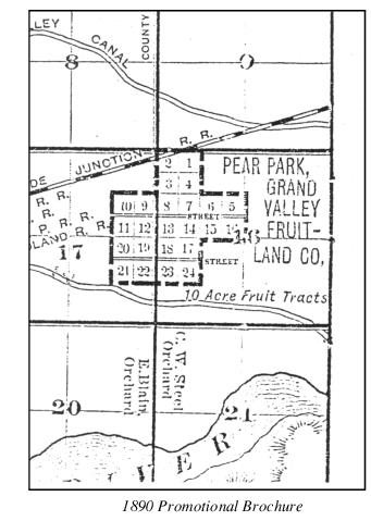
The Grand Valley Fruit Land Company offered 10-acre tracts in the vicinity of 30 and D Roads specifically marketed for their orchard potential. An 1890 promotional brochure stated:
This tract of land contains 240 acres, lies three miles east of Grand Junction and is advantageously located for the purpose of subdivision into 10-acre tracts, having a good frontage on established county roads. The soil is a mixture of sand and adobe, easily worked and very rich. The surface of the ground is level: every foot of it can be irrigated without extra cost for leveling. Being just the proper distance from the main line of the Grand Valley Canal to obtain the fall necessary to cover all of the land with water, the expense of building laterals will be very small. There are no improvements on the land.
Adjoining farms are owned by C.W. Steele and E. Blain, prominent and successful farmers and horticulturists in Grand Valley for the past 7 years. What they have done on their land, proves what can be done on this and a standing advertisement for the property. Water for this tract can be rented at a cost of $1.75 per acre per year.
Thus, an agricultural community grew up in this area very early in the settlement history of the Grand Valley. Several residences in the area date to the 1890s and other community uses such as churches and schools were established very early as well. The Pear Park School was constructed pre-1900 and replaced by a new building in 1929. The latter closed in 1969 but is still used as a day care center. The Pear Park Baptist Church began serving the community in 1895 and constructed its first building 1903. The church now occupies a new structure built in the 1950s and 60s located on the original site at the northeast corner of 31 and E Roads.
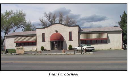
One of the most memorable long-time residents and contributors to the Pear Park area was Minnie Chatfield. Miss Chatfield arrived in Mesa County in 1903 where she remained for 79 years until her death at age 101. She began teaching at the Pear Park School in 1906 and retired in 1951. For another half-dozen years, she substituted for District 51’s absentee teachers. She was also very active in the Pear Park Baptist Church. Chatfield Elementary, located at 32 and D-1/2 Roads, is named for Minnie Chatfield.
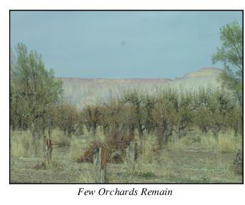
Valley-wide, two serious problems threatened fruit production following the first decade of the 20th century. First, unlined canals seeped because there was no runoff ditch system; water ran into the orchards and stayed around the trees, either drowning them or killing them with alkali. Hundreds of acres of orchards were uprooted. The second serious threat to fruit production was the coddling moth. The mild weather in the Grand Valley and a lack of regulations requiring removal of orchard waste perpetuated the moth problem. In addition, present residents in Pear Park indicate that in the 1920s fruit trees were infested with a bacterial disease spread by insects (known as “fire blight”) that depleted the orchards. Only a few scattered orchards remain in the area today.
The Pear Park area also grew up around the Grand Junction Indian School. The school, known as Teller Institute, was organized in 1885 to “materially aid in the civilization of the Utes” and named after Senator Henry M. Teller, then Secretary of the Interior. Grand Junction citizens donated 160 acres to the Department of the Interior. The first building was completed in the summer of 1886 and 30 Indians, mostly Utes, enrolled for the fall term. The student population soon grew to 144 boys representing nine tribes. The school was opened to girls in later years. The largest enrollment was 300 students in 1899. Academics were taught as well as other interests such as cooking and raising stock on the school’s farm. The school closed in 1911 when government policy decreed that Indian education would be better handled on reservations.
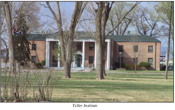
The Indian School land remained idle or minimally used until World War I when local interest began in a State Home and Farm for Mental Defectives. Alkali had seeped throughout the acreage and the Bureau of Reclamation reworked the land before it could be farmed. The buildings had been well constructed for the school and did not require much renovation. The State approved the use in 1919 and it opened with 186 patients in 1920. It was operated as a central residence for the mentally handicapped until the 1980s; at that time many patients were moved to group homes. Today the old institute site is known as the Grand Junction Regional Center for Developmental Disabilities.
(Res. 13-05, 1-5-05)
37.08.020 Historic structures and sites.
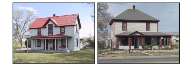
Historic buildings and sites are scattered across the Pear Park planning area. These are primarily residential structures remaining on parcels of land that may have been farms or orchards in the past. Some of these have already been surrounded by new residential development and many have already been lost as the former agricultural properties have developed.
A windshield survey of historic resources in the Pear Park neighborhood was conducted as a part of this study. Many potentially eligible structures were noted and 13 structures/sites were identified that will be documented in greater detail by a 2004 – 2005 historic resources survey. These structures, listed below, represent the best remaining examples of the various types of historic structures and sites found within the Pear Park neighborhood. Photographs of each of these as well as a more comprehensive list of the potentially eligible structures are included in Appendix B.
|
LOCATION |
|
YEAR BUILT |
|
|---|---|---|---|
|
Teller Institute |
|
Various |
The City of Grand Junction established a local Register of Historic Sites, Structures and Districts in 1994. To date, and since the majority of Pear Park is in unincorporated Mesa County, no properties in the area have been included on the local register; however, many are eligible for designation as noted in the inventory referenced to the left and included as Appendix B, most notably those documented in greater detail by the 2004 – 2005 historic resources survey. |
|
3070 D Road |
|
1900 |
|
|
3178 D Road |
|
1907 |
|
|
2990 D 1/2 Road |
|
1905 |
|
|
3117 D 1/2 Road |
|
1906 |
|
|
3080 D 1/2 Road |
|
1900 |
|
|
3085 D 1/2 Road |
|
1900 |
|
|
3095 D 1/2 Road |
|
1895 |
|
|
3168 D 1/2 Road |
|
1909 |
|
|
3170 D 1/2 Road |
|
1955 |
|
|
3046 E Road |
|
1914 |
|
|
3055 E Road |
|
1900 |
|
|
350 30 Road |
|
1897 |
(Res. 13-05, 1-5-05)
37.08.030 Historic landmarks/cultural landscapes.
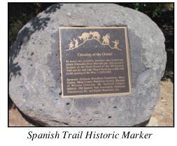
The Old Spanish Trail was an important travel route from Santa Fe to California from the mid 1820s to the midpoint of the 19th century. The area that is now 28 1/4 Road and Unaweep Avenue is the historic site of the Old Spanish Trail crossing of the Colorado River. A historic marker at that location on the south bank depicts the steep slope where travelers crossed the river. The Old Spanish Trail is a designated National Historic Trail. The north side of the river in Pear Park has no such recognition of the significance of the crossing.
(Res. 13-05, 1-5-05)
37.08.040 Goals.
(a) Protect and maintain the unique features and characteristics of Pear Park which are significant links to the past, present and future.
(b) Establish and promote the historical pride and heritage of Pear Park.
(c) Document potential historic sites and structures as a means for designating properties on local, State and/or national registers.
(d) Work with property owners to pursue official designation, preservation, adaptive reuse restoration, or relocation of eligible, significant historic structures and sites.
(Res. 13-05, 1-5-05)
37.08.050 Implementation strategies.
(a) In cooperation with appropriate local, State and national organizations, complete both reconnaissance and intensive level surveys of the Pear Park area to inventory historic sites, structures and districts and identify those that could potentially be designated on local, State and/or national historic registers.
(b) Whenever possible, new development should not remove or disrupt significant historic or traditional uses, landscapes, structures, fences or architectural features. Consultation with the Colorado Historical Society, Bureau of Land Management, National Park Service, City of Grand Junction Historic Preservation Board, Mesa County Historical Society and the Museum of Western Colorado is valuable in this effort and should be done as early as possible in the development process.
(c) Adopt compatibility requirements for new development to protect the historic use of existing and adjacent properties.
(d) Adopt a resolution to establish a local Mesa County historic register.
(e) The City and County will encourage the placement of an historical marker at the Old Spanish Trail crossing of Colorado River on the north side of the river to match the existing historical marker at 28 1/4 Road and Unaweep Avenue on the south side of the river.
(Res. 13-05, 1-5-05)