


Chapter 37.36
ENVIRONMENTAL RESOURCES/RIVER CORRIDOR
Sections:
37.36.010 Public and private values.
37.36.050 Mineral extraction/reclamation.
37.36.070 Implementation strategies.
37.36.010 Public and private values.
The Colorado River Corridor is just one of many parts within a functioning ecological unit that also includes the natural and built environment. Many important, and sometimes conflicting, public and private values must be maintained and managed inside the corridor. One big challenge is working to help development and wildlife coexist.
(a) Public values include:
(1) Natural areas, wildlife habitat, environmental and water quality.
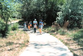
(2) Recreation, parks, trails and designated public access areas.
(3) Rural character and agricultural use.
(4) Floodplain and flood hazard management.
(5) Scenic and aesthetic resources.
(6) Education and interpretation.
(7) Historic landmarks and cultural landscapes.
(b) Private values include:
(1) Agriculture.
(2) Gravel extraction and reclamation.
(3) Residential, cultural, commercial and business development.
(Res. 13-05, 1-5-05)
37.36.020 Wildlife.
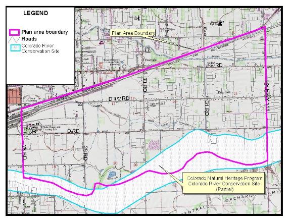
The Colorado Natural Heritage Program (CNHP) has mapped plant and animal communities of State and National Importance within Mesa County. The information from this program includes recommendations for resource management and stewardship plans to protect resources of the area. The river corridor through the Pear Park neighborhood lies within the Colorado River at Grand Junction conservation site as identified in the Natural Heritage Inventory of Mesa County, Colorado (Lyon, P., Pague, C., Rondeau, R., et. al. 1996). The site is classified as B1 (outstanding significance). Several rare and endangered species are listed in the report. Colorado Natural Heritage rarity ranks do not imply any legal designation or regulatory actions. The entire Colorado River Corridor, one of three “Colorado Important Bird Areas” (Partners in Flight, an International Cooperative) in the State, is home to an estimated 140 avian species, 15 of which are listed as rare or imperiled.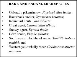
The Colorado Division of Wildlife (CDOW) is responsible for all wildlife management in Colorado with the exception of migratory and federally listed endangered species. The CDOW composite map for Mesa County of important areas of wildlife/human interactions, called “Potential Impact to Wildlife Map,” depicts areas with six levels of impact to wildlife. Three locations in Pear Park are identified as very high in potential impact: Indian Wash, Lewis Wash and the Colorado River Corridor.


In an effort to protect wildlife habitat, Mesa County requires any development that falls within a moderate, high or very high potential for impact category to consult with the CDOW to substantiate the basis for the potential impact and to address various, specific measures to avoid, minimize or mitigate negative impacts to wildlife and its habitat. Regulations of the City of Grand Junction Zoning and Development Code do not allow new structures within 100 feet of the floodway of the river as defined by the Federal Emergency Management Act (FEMA). The Mesa County Land Development Code does not allow new structures within 100 feet of the floodway of the Colorado River or as recommended by the CDOW.
Colorado Division of Wildlife allows waterfowl hunting along the Colorado River within the Pear Park area (see Chapter 37.32 GJMC, Public Safety). Hunting is an important tool for wildlife management and stewardship.
The Colorado River Wildlife Area (CRWA) is located north of the Colorado River between 30 and 31 Roads and immediately south of D Road. The entrance road and parking lot (including the public restroom) is managed by Colorado State Parks. The short north/south trail which connects the parking lot to the Colorado River Trail is also managed by Colorado State Parks. The portion of the Colorado River Trail which parallels the Colorado River is owned and managed by Colorado State Parks. The remaining portion of the CRWA is managed by Western Colorado Wildlife Habitat Association (WCWHA). The CRWA, with the exception of the trail and parking area, is closed to the public year-round for wildlife protection.
The Orchard Mesa Wildlife Area located on the south side of CRWA directly across the River is solely managed by WCWHA. While some hunting is allowed on this property, public access is greatly limited and seasonal closure exists from March 15th through July 15th. These properties were acquired and developed to mitigate/replace the incidental fish and wildlife values/habitat lost as a result of the construction to improve canal and lateral systems associated with the Grand Valley Unit in Mesa County. To compensate, the Bureau of Reclamation worked with the U.S. Fish and Wildlife Service and the Colorado Division of Wildlife to acquire, develop and preserve permanent wildlife habitats along the Colorado River.
(Res. 13-05, 1-5-05)
37.36.030 Noxious weeds.
Aggressive weeds (nonnative, invasive, undesirable plant species) and a lack of their control can present significant problems. As of 2004, there are 19 noxious weeds on the Mesa County Noxious Weeds list that require control (see list in GJMC 34.44.010); however, the primary nonnative undesirable species of concern in the planning area are: purple loosestrife, Lythrum salicaria; Russian knapweed, Acroptilon repens; whitetop/hoary cress, Cardaria draba; and yellow toadflax, Linaria vulgaris. These four plants are designated as undesirable plants in Mesa County and are being controlled/managed by policies set forth in the Mesa County Weed Management Plan. In addition, tamarisk species are on the list, but control is not mandatory. The Russian olive, Elaeagnus angustifolia, and tamarisk, Tamarisk parviflora and ramosissima, pose a threat to many native upland and wetland plant communities because of their aggressive nature and prolific reproductive rate, although the Russian olive is not on the list. They both have the ability to eliminate entire native plant communities. The Tamarisk Coalition in Mesa County has been active in efforts to remove tamarisk and Russian olive trees from areas along the Colorado River floodplain.
The County is committed to weed management and has created a cost share program for landowners. The cost share program makes funding available to help defray the cost of control efforts.
The City manages noxious weeds inside of the City limits and utilizes integrated weed management planning/techniques to control/eradicate weeds and numerous nonnative, undesirable plant species. The City requires eradication of five weed species: Russian knapweed, Centaurea repens; diffuse knapweed, Centaurea diffusa; spotted knapweed, Centaurea maculosa; purple loosestrife, Lythrum salicaria; and leafy spurge, Euphorbia esula.
The City manages noxious weeds by:
(a) Weed mapping (specifically Russian knapweed and purple loosestrife).
(b) Working with landowners: requesting management plans for the control/eradication of the weeds from property owners with the plants on their property.
(c) Annual public outreach efforts: reminding owners of their responsibility to control/eradicate noxious weeds and nonnative, undesirable plants.
(d) Providing technical expertise on integrated weed management planning techniques and implementation methods (mechanical, chemical, biological and cultural).
(e) Maintaining, updating, and identifying any recognized change in effective methods of control.
(f) Working with other land management agencies for control of the four undesirable noxious weeds in rights-of-way as identified by the County.
In addition to the five specific noxious weeds identified above, the City has an annual proactive weed abatement program from May through October. The program requires property owners to keep all weeds on their property and adjacent rights-of-way between curb and center of alley to a height below six inches. Undeveloped lands over one acre in size are required to cut a 20-foot perimeter along any roadway, and along any side of the property adjacent to a developed property. Agricultural lands (as defined in C.R.S. § 39-1-102(1.6)(a)) are required to keep weeds cut within 20 feet of any adjacent developed property. Property owners are responsible for any cost of cutting and removing of weeds by City crews that are not removed within 10 days after notification of the violation.
(Res. 13-05, 1-5-05)
37.36.040 Wetlands.

Wetlands in the planning area are among the most environmentally important ecosystems in the County and also the most vulnerable to development pressures. Mapped wetlands of Mesa County by the Colorado Natural Heritage Program (CNHP) identifies the Colorado River Corridor as an important wetland area. Wetland habitat has been created on the Colorado River Wildlife Area as part of the mitigation requirements associated with the loss of wildlife values/habitat which resulted from improvements to canal and lateral systems for salinity control. The principal method of protecting wetlands and riparian areas is through existing City and County floodplain regulations.
(Res. 13-05, 1-5-05)
37.36.050 Mineral extraction/reclamation.
Gravel is a necessary resource for a community. It is needed for construction projects to serve a growing population and essential to the local economy. Gravel deposits should be extracted according to a rational plan that avoids waste of the minerals and causes the least practicable disruption of the ecology and quality of life of the citizens of affected areas.

With input from the Pear Park area gravel industry and using the 1978 Mineral Resources Survey of Mesa County, a Pear Park Neighborhood Plan Mineral Resources Map was created and is included as part of this Plan (see Mineral Resource Map at the end of this chapter). Nothing in the designation of aggregate resource areas is intended to preclude approval of applications for extractive uses outside the designated areas which meet development requirements.
The 1978 Mineral Resources Survey of Mesa County states that the “Colorado River terrace deposits exist in the Pear Park area and these deposits are about 12 to 22 feet thick with 10 to 15 feet of overburden.” Gravel extraction in the planning area occurs along the north side of the river wherever access is available and practical. Much of the gravel is used for building materials and highway projects.
Issues facing the gravel industry include:
(a) Impacts of gravel extraction and processing operations adjacent to or nearby existing residential land uses.
(b) Existing residential uses limiting gravel extraction and processing operations.
(c) Lack of general knowledge by the public of the mineral extraction policies and location of resources.
(d) Reclamation and future use of mined-out gravel pits.
(e) Visual/ecological impacts along the Colorado River.
A mineral extraction plan is intended to facilitate protection of the area’s commercial mineral deposits from encroachment by incompatible land uses that would limit the options of future decision-makers in considering the demand for aggregate resources; however, applicants applying for a permit for gravel or other extractive use in an aggregate gravel or resource area must address all environmental and compatibility issues.
Mesa County and the City of Grand Junction are very interested in the reclamation of sites after the resources are removed. The State Mined Land Reclamation Board has developed standards and procedures for reclamation plans. Within their authority, the County and City work with mining permit applicants to identify appropriate uses and landscape forms for the reclamation plan. Preferred uses are those consistent with this adopted land use plan or providing quality recreation or open space and wildlife habitat opportunities.
(Res. 13-05, 1-5-05)
37.36.060 Goals.
(a) Protect the river corridor from adverse impacts of development and land use activities in Pear Park.
(b) Maintain a multi-use corridor in which the river and surrounding lands are carefully managed to protect and enhance a diverse set of public values while allowing appropriate private uses within the corridor.
(Res. 13-05, 1-5-05)
37.36.070 Implementation strategies.
(a) The City, County, and 5-2-1 Drainage Authority will work together to develop stormwater best management practices for the Colorado River floodplain.
(b) The City, County, Federal, State, and private agencies and organizations with an interest in the Colorado River will work together to protect and enhance the Colorado River Corridor and promote environmental education opportunities.
(c) Develop and adopt code language (Mesa County Land Development Code and City of Grand Junction’s Zoning and Development Code) that establishes a Pear Park Colorado River Corridor overlay zone district addressing:
(1) Channel stability to assure adequate setbacks are provided to account for the inherent instability of the channel and recognize that river movement across the landscape is a natural process that may be accelerated by development.
(2) Scenic views of the river, its natural setting and features, Grand Mesa, Mount Garfield, the Book Cliffs, and the Uncompahgre Plateau.
(3) The CNHP report as a guiding document for the protection of sensitive species.
(4) Recreational features located and designed to avoid or minimize impacts to unique vegetation, wildlife habitats, water quality and other environmental values.
(5) Multiple implementation tools such as conservation easements, land acquisition, enforcement of existing floodplain regulations and other conservation techniques, to protect the Colorado River 100-year floodplain.
(6) Best management practices for resource protection that considers both on- and off-site impacts from development.
(7) Specific, identified high-priority resources and long-term plans for management and protection.
(d) Gravel extraction areas along the Colorado River floodplain shall be reclaimed for agricultural, residential, recreational or other permitted uses.
(e) Gravel extraction shall occur as shown on the Pear Park Neighborhood Plan Mineral Resources Map.
(f) Revise the “no shoot” boundary along the Colorado River. Specifically: move the existing west boundary which is just west of Indian Road east to 29 Road. Move the existing north boundary (D Road) south to C 1/2 Road. See figure below.

(Res. 13-05, 1-5-05)