


Chapter 42.08
HAZARD MITIGATION PLAN
Sections:
Article I. General Provisions
42.08.020 Plan section review and analysis – 2020 update.
Article II. Introduction and Planning Area Profile
42.08.050 Background and scope.
42.08.060 Planning area profile.
42.08.070 Geography and climate.
42.08.080 Population and demographics.
Article III. Planning Process
42.08.110 Multi-jurisdictional participation.
42.08.120 Ten-step planning process.
42.08.130 Phase 1 – Organize resources.
42.08.140 Phase 2 – Assess risk.
42.08.150 Phase 3 – Develop the mitigation plan.
42.08.160 Phase 4 – Implement the plan and monitor progress.
Article IV. Risk Assessment
42.08.180 Hazard identification.
42.08.190 Disaster declaration history.
42.08.260 Hazardous materials.
42.08.270 Landslide, rockfall.
42.08.290 Severe winter weather.
42.08.310 Windstorms/tornadoes.
42.08.320 Hazard profile summary.
42.08.330 Vulnerability assessment.
42.08.340 Community asset inventory.
42.08.350 Critical facilities and infrastructure.
42.08.360 Natural, historic, and cultural assets.
42.08.400 Imperiled natural plant communities.
42.08.410 Ecologically sensitive areas.
42.08.420 Historical and cultural resources.
42.08.440 Vulnerability by hazard.
42.08.500 Landslide, mudflow/debris fall, rockfall.
42.08.520 Severe winter weather.
42.08.535 Changes in development.
Article V. Mitigation Strategy
42.08.540 Mitigation strategy.
42.08.550 Goals and objectives.
42.08.560 Identification and analysis of mitigation actions.
42.08.570 Implementation of mitigation actions.
Article VI. Plan Implementation and Maintenance
42.08.580 Plan implementation and maintenance.
42.08.600 Monitoring, evaluating, and updating the plan.
42.08.610 Hazard Mitigation Planning Committee.
42.08.620 Plan maintenance schedule.
42.08.630 Plan maintenance process.
42.08.640 Incorporation into existing planning mechanisms.
42.08.650 Continued public involvement.
Article VII. Community Profiles
42.08.690 City of Grand Junction.
42.08.710 Fire protection districts.
Appendix A Plan Adoption Resolutions
Appendix B Kick-off Meeting Invitation List
Appendix C Invitation Letter to Kick-off Meeting
Appendix D HMPC Meeting Agendas, Sign-In Sheets, and Sample Worksheets
Appendix E Data Collection Worksheets
Appendix F Mesa County Hazard Mitigation Planning Committee Members
Appendix G Public Review and Comment Notice
Appendix H Public Hazard Perception Survey Results
Prior legislation: Res. 95-04.
Article I. General Provisions
42.08.010 Executive summary.
The purpose of natural hazards mitigation is to reduce or eliminate long-term risk to people and property from natural hazards. Mesa County’s original Mitigation Plan was completed in 2004 and approved by FEMA in January 2005. The 2004 plan was revised in 2009/2010 and again in 2015 pursuant to the requirements of the Disaster Mitigation Act of 2000 which requires a five year revision in order to achieve eligibility for the Federal Emergency Management Agency (FEMA) Flood Mitigation Assistance, Pre-Disaster Mitigation, and Hazard Mitigation Grant Programs. This 2020 plan is an update to the 2015 plan.
The Mesa County Hazard Mitigation Plan is a multi-jurisdictional plan that covers the following local governments, special districts, and authorities that participated in the planning process and who identified future mitigation projects for their jurisdiction. Additional jurisdictions participated in the planning process but did not define a specific project (see participant list):
|
Mesa County |
Lower Valley Fire Protection District |
|
City of Grand Junction |
Clifton Fire Protection District |
|
City of Fruita |
Plateau Valley Fire Protection District |
|
Town of Collbran |
Grand Junction FD and Grand Junction Rural FPD |
|
Town of Palisade |
DeBeque Fire Protection District |
|
Town of DeBeque |
|
New participants during this plan update include the Clifton Fire Protection District.
The County’s planning process followed a methodology prescribed by FEMA, and much of the information contained in this plan was developed using jurisdictional information, plans and documents.
Mesa County’s process began with the formation of a Hazard Mitigation Planning Committee (HMPC) comprised of key stakeholders from Mesa County, participating jurisdictions, and State and federal agencies. The HMPC conducted a risk assessment that identified and profiled hazards that pose a risk to Mesa County, assessed the County’s vulnerability to these hazards, and examined the capabilities in place to mitigate them. The County is vulnerable to several hazards that are identified, profiled, and analyzed in this plan. However, floods, wildfires, and rock falls-landslides are among the hazards that can have a significant impact on the County and are the hazards for which specific mitigation projects have been identified. Based upon the risk assessment, the HMPC identified goals and objectives for reducing risk to hazards. The goals and objectives of this hazard mitigation plan are to:
(a) Goal 1: Reduce risk to the people, property, and environment of Mesa County from the impacts of natural hazards.
(1) Minimize the vulnerability of existing and new development to hazards.
(2) Increase education and awareness of hazards and risk reduction measures.
(3) Improve comprehensive wildfire planning, funding, and mitigation.
(4) Strengthen floodplain management programs.
(5) Enhance assessment of multi-hazard risk to critical facilities and infrastructure.
(b) Goal 2: Minimize economic losses.
(1) Strengthen disaster resistance and resiliency of businesses and employers.
(2) Promote and conduct continuity of operations and continuity of governance planning.
(3) Reduce financial exposure of County and municipal governments.
(c) Goal 3: Implement the mitigation actions identified in this plan.
(1) Engage collaborative partners, community organizations, businesses, and others.
(2) Integrate mitigation activities into existing and new community plans and policies.
(3) Monitor, evaluate, and update the mitigation plan.
To meet identified goals and objectives, the plan recommends the mitigation actions summarized in Table 1. The HMPC also developed an implementation plan for each action, which identifies priority level, background information, ideas for implementation, responsible agency, timeline, cost estimate, potential funding sources, and more.
The Hazard Mitigation Plan has been formally adopted by the Mesa County Board of County Commissioners and the governing bodies of each participating jurisdiction and will again be revised within a five-year timeframe.
|
Mitigation Action Matrix |
||||
|---|---|---|---|---|
|
Jurisdiction |
Action |
Priority |
Goals Addressed |
Hazards Addressed |
|
Multi-jurisdictional |
Coordinate biannual reviews. |
High |
Goal 3 |
Multi-Hazard |
|
Multi-jurisdictional |
Continue public involvement in mitigation activities. |
High |
Goal 1 |
Multi-Hazard |
|
Multi-jurisdictional |
Coordinate and complete a continuity of operations/continuity of governance (COOP/COG) plan. |
High |
Goal 2 |
Multi-Hazard |
|
Multi-jurisdictional |
Identify and prioritize fuel reduction projects around critical facilities and infrastructure in wildfire hazard areas. Community education regarding the risk of wildfires. |
High |
Goal 1 |
Wildfire |
|
Town of Palisade: Fire Department |
Create a fire mitigation plan to protect vital raw water supplies and infrastructure. Conduct on the ground mitigation to reduce the potential for wildfire. |
High |
Goal 1, 2 |
Wildfire |
|
Multi-jurisdictional |
Incorporate information contained in Hazard Mitigation Plan into other planning mechanisms, when appropriate. |
High |
Goal 1, 2 |
Multi-Hazard |
|
Multi-jurisdictional |
Project includes 2 detention basins and 535 feet of box culvert improvements that will remove 269 structures from 100-year floodplain, including 2 churches and 1 elementary school, and decrease emergency response arterial inundation (Hwy. 50) by 0.43 feet (Orchard Mesa detention and conveyance improvements). |
Medium |
Goal 1, 2 |
Flooding |
|
Mesa County |
Adobe Creek: Overbank flooding of properties is common during small events. Project will upgrade 13 structures and 2.5 miles of channel to achieve flow capacity for 10-year event level. |
Medium |
Goal 1, 2 |
Flooding |
|
Mesa County |
Douglas Wash: The existing drainage way and crossing structures are undersized and cannot convey the 100-year storm event. More than 55 properties are within the flooding area. A study was completed and the recommended solution was to construct detention areas to control the flow within the channel. |
Medium |
Goal 1, 2 |
Flooding |
|
Multi-jurisdictional |
Mitigation project for the upper and lower portions of the Leach Creek drainage. These projects would provide mitigation to flood events for the area of Leach Creek above the confluence with Ranchmen’s Ditch. |
Medium |
Goal 1, 2 |
Flooding |
|
Mesa County, City of Grand Junction, City of Fruita, Town of Palisade |
NFIP Compliance: Jurisdictions will incorporate and reference DFIRM maps in regulations as new floodplains are mapped. Audits of regulations will ensure compliance with NFIP in all program areas. |
Medium |
Goal 1 |
Flooding |
|
Multi-jurisdictional |
Identify and map geologic hazard zones and incorporate into master planning. |
Medium |
Goal 1, 3 |
Landslide-Rockfall-Mudflow-Debris Flow |
|
Multi-jurisdictional |
Real time rainfall data is lacking in Mesa County. An automated rainfall ALERT network would allow real time rainfall data access by local officials and National Weather Service forecasters for more timely flash flood warnings. |
Medium |
Goal 1, 3 |
Flooding |
|
Multi-jurisdictional |
A Basin Master Plan for Big Salt Wash will be completed. The plan will identify at risk properties, conveyance and detention mitigation alternatives and costs. |
Low |
Goal 1 |
Flooding |
|
Multi-jurisdictional |
Community Resilience Planning: Develop the ability to function and sustain critical systems; adapt to changes in the physical, social, or economic environment; be self-reliant if external resources are limited or cut off. |
Medium |
Goal 1, 2, 3 |
Multi-Hazard |
|
Town of Palisade |
Fuel and debris reduction: Remove overgrowth, slash, and debris from steep river bank. |
High |
Goal 1 |
Wildfire, Flooding |
|
DeBeque FPD |
District wildland fire assessment: Assess wildland-urban interface issues in district. |
Medium |
Goal 1 |
Wildfire |
|
DeBeque FPD |
Reduce amount of fuels residents pile up for burning in and around the Town of DeBeque by establishing a wood chipping program. |
Medium |
Goal 1 |
Wildfire |
|
Multi-Jurisdictional |
Review and update the 2012 Countywide Community Wildfire Protection Plan |
High |
Goal 1 |
Wildfire |
|
Multi-Jurisdictional |
StormReady Recertification: Complete actions necessary to maintain StormReady Certification. |
Medium |
Goal 1 |
Multi-Hazard |
|
Clifton FPD and Mesa County |
Lewis Wash wildfire mitigation project |
High |
Goal 1 |
Wildfire |
|
Town of Palisade |
Riverbend Park wildfire mitigation project |
High |
Goal 1 |
Wildfire |
|
City of Fruita and Lower Valley FPD |
Big Salt Wash wildfire mitigation project – Evening Breeze section |
High |
Goal 1 |
Wildfire |
|
City of Grand Junction and GJ Rural FPD |
Identify, prioritize, support, and conduct fuels mitigation in Wildland Urban Interface. |
High |
Goal 1 |
Wildfire |
|
City of Grand Junction |
Emergency Action Plans for Dam Safety |
High |
Goal 1, 2 |
Flooding |
|
City of Grand Junction |
Fire Mitigation for Grand Junction Watershed |
High |
Goal 1 |
Wildfire |
|
City of Grand Junction |
Carson Lake Dam Rehabilitation and Early Warning System |
High |
Goal 1, 2 |
Flooding |
Following is a brief project update, from the goals, objectives and projects identified in the approved 2015 plan.
|
2015 Actions |
Status |
Reason |
|---|---|---|
|
Coordinate annual reviews |
Ongoing |
|
|
Public involvement in mitigation activities |
Complete |
|
|
COOP/COG planning |
Ongoing |
|
|
Identify and prioritize fuel reduction projects |
Ongoing |
|
|
Palisade watershed protection plan and projects |
Ongoing |
Plan complete projects ongoing |
|
Incorporate HMP into other plans |
Ongoing |
As plans are updated. |
|
Orchard Mesa Detention and Conveyance |
Partially Complete – Ongoing |
The Orchard Mesa project was constructed, however the pipes have not been increased |
|
Adobe Creek Project |
Ongoing |
Project not started yet |
|
Bosley Wash Project |
Complete |
|
|
Douglas Wash Project |
Ongoing |
Currently being worked on by Mesa County Staff |
|
Leach Creek Project |
Ongoing |
Partially complete. Work carried out in 2012, 2013, and 2014. |
|
NFIP Compliance |
Ongoing |
Work continues as new floodplains are mapped |
|
Mapping of geologic hazard zones. Incorporation into master planning |
Ongoing |
Hazard zones referenced in plans. LiDAR mapping of West Salt Creek Landslide area |
|
Real time rainfall data network |
Deferred |
Funding opportunities have not been explored |
|
Big Salt Wash basin master plan |
Deferred |
Staff time reallocated to other projects |
|
StormReady Recertification |
Complete |
|
|
Community Resilience Planning |
Deferred |
Assigned staff resigned. Project not reassigned. |
|
Riverbank Fuel and debris reduction |
Ongoing |
|
|
DeBeque FPD district wildland fire assessment |
Ongoing |
|
|
DeBeque wood chipping/burn reduction project |
Ongoing |
|
(Res. 61-20, 10-7-20; Res. 32-15, 7-1-15; Res. 05-10, 1-6-10)
42.08.020 Plan section review and analysis – 2020 update.
This multi-jurisdictional, multi-hazard mitigation plan update involved a comprehensive review and update of each section of the 2015 plan. The process followed to review and revise this plan was similar to the planning process for the 2015 plan. As part of this plan update, all sections of the plan were reviewed and updated to reflect new data and knowledge of hazards and risk, risk analysis process, capabilities, participating jurisdictions and stakeholders, and mitigation strategies. The plan was also revised to reflect changes in development and property values based on County Assessor data. Valid information from the 2015 plan was carried forward and included in this plan update.
This plan update was filed with the State of Colorado Division of Homeland Security and Emergency Management as a component of Mesa County’s annual emergency management work plan. As a result, this plan update was funded, in part, with Emergency Management Performance Grant funds.
The following list summarizes plan updates by plan section:
(a) Introduction and Planning Area Profile.
(1) Updated population and demographic information for Mesa County and participating jurisdictions.
(2) Updated economy description.
(3) Updated labor force and unemployment rate data.
(b) Planning Process.
(1) General text edits to update dates associated with planning timeline.
(2) Updated jurisdiction participation table to reflect participation in plan update process.
(3) Edited the Hazard Mitigation Planning Committee list to reflect individual participants in the update process.
(4) Updated the public involvement process for plan update.
(c) Risk Assessment.
(1) Reviewed hazards list for possible modifications.
(2) Reviewed hazards from the 2018 Colorado State Hazard Mitigation Plan.
(3) Updated disaster declaration history to include 2015-2020 data.
(4) Reviewed hazard class for dams in Mesa County.
(5) Reviewed and updated repetitive loss property information.
(6) Updated Tier II reporting facility numbers.
(7) Updated previous occurrence history for hazardous materials.
(8) Updated NCDC data for severe winter weather from 2015-2019.
(9) Updated previous occurrence history for wildfire to include events from 2015-2019.
(10) Reviewed and updated hazard profile summary and scoring.
(11) Reviewed and updated critical facilities and infrastructure matrix.
(12) Reviewed and updated economic assets.
(d) Mitigation Strategy.
(1) Updated Mitigation Action Matrix to reflect new and continued mitigation projects.
(2) Reviewed and updated continued mitigation project descriptions.
(3) Added new mitigation projects and removed completed ones.
(e) Plan Implementation and Maintenance.
(1) Reviewed plan implementation and maintenance.
(f) Community Profiles.
(1) Updated population data using 2019 Colorado State Demographer estimates for prior plan participants.
(2) Reviewed and updated jurisdiction hazard profiles for prior plan participants.
(3) Updated community asset inventory using a structured GIS analysis using most recent County Assessor and population data.
(4) Reviewed and updated jurisdiction capability assessments for prior plan participants.
(5) Reviewed district profiles for participating special districts.
(6) Created new district profile for new participating district, Clifton Fire Protection District.
(Res. 61-20, 10-7-20; Res. 32-15, 7-1-15; Res. 05-10, 1-6-10)
42.08.030 Plan requirements.
44 CFR Requirement Section 201.6(c)(5): The local hazard mitigation plan shall include documentation that the plan has been formally adopted by the governing body of the jurisdiction requesting approval of the plan. For multi-jurisdictional plans, each jurisdiction requesting approval of the plan must document that it has been formally adopted.
The following jurisdictions participated in the development of this plan and have adopted the multi-jurisdictional plan. A sample resolution is provided and all signed copies of resolutions can be found in Appendix A of this plan.
|
Mesa County |
Lower Valley Fire Protection District |
|
City of Grand Junction |
Plateau Valley Fire Protection District |
|
Town of Palisade |
Grand Junction FD and Grand Junction Rural FPD |
|
City of Fruita |
Clifton Fire Protection District |
|
Town of Collbran |
DeBeque Fire Protection District |
|
Town of DeBeque |
|
RESOLUTION NO. ______
A RESOLUTION ADOPTING THE REVISED MESA COUNTY, COLORADO
MULTI-HAZARD MITIGATION PLAN
WHEREAS, natural hazards in Mesa County have the potential for loss of life and significant property damage,
WHEREAS, the County of Mesa recognizes the importance of reducing or eliminating vulnerability of disasters caused by natural hazards for the overall good and welfare of the community,
WHEREAS, the County of Mesa, Office of Emergency Management has revised the comprehensive, multi-jurisdictional, Multi-Hazard Mitigation Plan to identify both natural and manmade disasters and developed strategies to mitigate those hazards,
WHEREAS, the Federal Disaster Mitigation Act of 2000 requires jurisdictions to prepare and adopt a Multi-Hazard Mitigation Plan to be eligible for future pre-disaster and post disaster federal funding for mitigation purposes, and
WHEREAS, the County of Mesa has identified and justified a number of proposed projects and programs needed to mitigate the vulnerabilities of the County to the impacts of future disasters to be included in this revised Multi-Hazard Mitigation Plan.
NOW, THEREFORE, BE IT RESOLVED BY THE BOARD OF COUNTY COMMISSIONERS OF MESA COUNTY, COLORADO:
Section 1: The County of Mesa hereby proposes to accept and approve the revised Mesa County Multi-Hazard Mitigation Plan.
Section 2: The plan participants are requested and instructed to pursue available funding opportunities for implementation of the proposals designated therein, and
Section 3: The plan participants will, upon receipt of such funding or other necessary resources, seek to implement the proposals contained in its section of the mitigation strategy, and
Section 4: The plan participants will continue to participate in the updating and revision of the Mesa County Multi-Hazard Mitigation Plan with a plan review and revision to occur within a five-year cycle, and designated staff will provide annual progress reports on the status of implementation of the plan to the Board of County Commissioners, and
Section 5: The plan participants will further seek to encourage the businesses, community groups, organizations and other stakeholders within the County of Mesa, to also participate in the updating and revision of this plan.
APPROVED on _________________.
(Res. 61-20, 10-7-20; Res. 32-15, 7-1-15; Res. 05-10, 1-6-10)
Article II. Introduction and Planning Area Profile
42.08.040 Purpose.
Mesa County and several other participating jurisdictions prepared this revision of the local Multi-Hazard Mitigation Plan to guide hazard mitigation planning to better protect the people and property of the County from effects of hazard events. This plan demonstrates the communities’ commitment to reducing risks from hazards and serves as a tool to help decision makers direct mitigation activities and resources.
With the completion of this plan revision, Mesa County and participating jurisdictions are eligible for certain federal disaster assistance, specifically, the Federal Emergency Management Agency’s (FEMA) Hazard Mitigation Grant Program, Building Resilient Infrastructure and Communities (BRIC) Program, and Flood Mitigation Assistance Program.
(Res. 61-20, 10-7-20; Res. 32-15, 7-1-15; Res. 05-10, 1-6-10)
42.08.050 Background and scope.
Each year in the United States, natural disasters take the lives of hundreds of people and injure thousands more. Nationwide, taxpayers pay billions of dollars annually to help communities, organizations, businesses, and individuals recover from disasters. These dollars only partially reflect the true cost of disasters, because additional expenses to insurance companies and nongovernmental organizations are not reimbursed by tax dollars. Many natural disasters are predictable, and much of the damage caused by these events can be reduced or even eliminated.
Hazard mitigation is defined by FEMA as “any sustained action taken to reduce or eliminate long-term risk to human life and property from a hazard event.” On average, each dollar spent on mitigation saves society an average of $11.00 in avoided future losses in addition to saving lives and preventing injuries. (National Institute of Building Science Multi-Hazard Mitigation Council 2018)
Hazard mitigation planning is the process through which hazards that threaten communities are identified, likely impacts of those hazards are determined, mitigation goals are set, and appropriate strategies to lessen impacts are determined, prioritized, and implemented. This plan documents Mesa County’s hazard mitigation planning process and identifies relevant hazards and vulnerabilities and strategies the County and participating jurisdictions will use to decrease vulnerability and increase resiliency and sustainability in Mesa County.
This revised plan was prepared pursuant to the requirements of the Disaster Mitigation Act of 2000 (Public Law 106-390) and the implementing regulations set forth by the Interim Final Rule published in the Federal Register on February 26, 2002 (44 CFR §201.6), and finalized on October 31, 2007. The 2007 amendments also incorporate mitigation planning requirements of the Flood Mitigation Assistance (FMA) program authorized by the National Flood Insurance Act of 1968.
While the Disaster Mitigation Act emphasizes the need for mitigation plans and more coordinated mitigation planning and implementation efforts, the regulations established the requirements that local hazard mitigation plans must meet in order for a local jurisdiction to be eligible for certain federal disaster assistance and hazard mitigation funding under the Robert T. Stafford Disaster Relief and Emergency Act (Public Law 93-288).
This revised plan addresses natural hazards and one manmade hazard – hazardous materials release. Although FEMA encourages communities to integrate manmade hazards into the mitigation planning process, the scope of this plan focused more on natural hazards. Additional plans have been developed to address other manmade hazards such as chemical, biological, and radiological terrorism through the Northwest All Hazard Emergency Management Region (NWAHEMR) and requires sensitivity towards confidentiality.
(Res. 61-20, 10-7-20; Res. 32-15, 7-1-15; Res. 05-10, 1-6-10)
42.08.060 Planning area profile.
Figure 1 shows a map of the Mesa County planning area, including the various jurisdictions who participated in the revision of this plan.
Figure 1: Hazard Mitigation Planning Area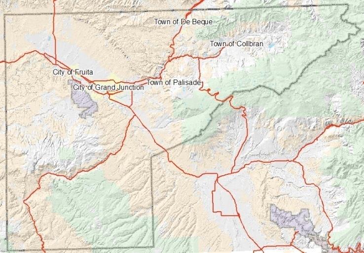
(Res. 61-20, 10-7-20; Res. 32-15, 7-1-15; Res. 05-10, 1-6-10)
42.08.070 Geography and climate.
Mesa County is located on the western border of Colorado, 250 miles west of Denver. Interstate 70, the State’s main east-west transportation corridor, travels directly through Mesa County. One of the 64 counties in Colorado, Mesa County encompasses 3,309 square miles, of which approximately 72 percent is publicly owned and is controlled primarily by the U.S. Forest Service and Bureau of Land Management. The City of Grand Junction is the County Seat and is the largest city in western Colorado. The Grand Junction area serves as the banking center, health care service provider and retail trade center for a large geographical area in western Colorado and eastern Utah.
The landscape of Mesa County has many unique features as it is located in a river valley surrounded by contrasting natural landmarks – such as the Colorado National Monument to the west, the Grand Mesa National Forest to the east, and the Bookcliffs to the north. These natural wonders provide diverse and abundant year-round recreational activities.
The Colorado National Monument is a beautiful geological display of towering red sandstone monoliths set against deep, shear-walled canyons which are dotted throughout the 20,000 acres of the park. The Grand Mesa National Forest is said to be the largest flat-topped mountain in the world. It has more than 200 lakes and is home to the Powderhorn ski area.
Mesa County’s mild climate provides a sharp contrast to the eastern slope of Colorado. Residents enjoy mild winter temperatures with lows averaging only 26 degrees Fahrenheit (minus three degrees Celsius) in January with year-round low humidity. (Mesa County 2008 Budget Book)
(Res. 61-20, 10-7-20; Res. 32-15, 7-1-15; Res. 05-10, 1-6-10)
42.08.080 Population and demographics.
Mesa County estimates its 2018 population to be 153,207 which ranks it as the eleventh largest population of the 64 counties in Colorado. The County estimates include data from the State Demographer’s office and includes more up-to-date information on components of change – births, deaths, and change in group population. Mesa County also considers school enrollment numbers, new housing permits, household increases, and vacancy rate. Mesa County has used State Demographer estimates when projecting future population and estimates the 2020 population to be 156,260 which is a two percent increase from 2018 as shown in Figure 2.
The 2010 Census marked a shift from the majority of the population living in unincorporated Mesa County to the cities and towns. In 2013, 51.7 percent were estimated to be in the incorporated areas and 48.3 percent were in the unincorporated areas. This is due in part to growth and annexations to Grand Junction, as well as the growth of Fruita since 2000. Mesa County’s population has also been urbanizing. In 1980, 70 percent of the County’s population lived in the urbanized area. The urbanized population has increased with each successive decade, and in 2010, the U.S. Census estimated 87.4 percent of the County’s total population lived in the urbanized area, which stretches from Fruita to Palisade.
Figure 2: Estimated County Population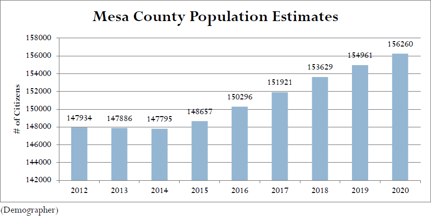
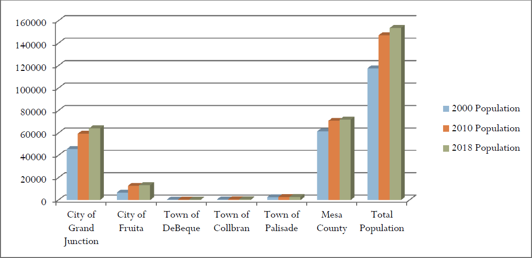
Figure 3: Jurisdiction Population
|
Area |
2000 Population |
2010 Population |
2018 Population |
% Change |
|---|---|---|---|---|
|
City of Grand Junction |
45,678 |
59,502 |
64,191 |
8% |
|
City of Fruita |
6,727 |
12,803 |
13,398 |
5% |
|
Town of DeBeque |
473 |
505 |
502 |
-1% |
|
Town of Collbran |
607 |
709 |
710 |
0% |
|
Town of Palisade |
2,585 |
2,748 |
2,792 |
2% |
|
Mesa County |
61,581 |
70,888 |
72,036 |
2% |
|
Total Population |
117,651 |
147,155 |
153,629 |
4% |
Mesa County’s median age of 39.1 is higher than both Colorado (37.9) and the U.S. (38.2). Mesa County’s population is generally older than Colorado, with 17.9 percent of the population over age 65 compared to 15.2 percent statewide. By 2030, the State Demographer projects that people over age 65 will account for 39 percent of the total population.
The U.S. Census Bureau demographic and social characteristics for Mesa County are shown in Tables 2 and 3 and Figure 4.
|
Population Estimates by Race and Hispanic Origin in 2018 |
Number |
Rank in State |
Pct Dist. in County |
Pct Dist. in State |
|---|---|---|---|---|
|
American Ind. or Alaskan Native Alone |
1,283 |
12 |
0.9% |
0.8% |
|
Asian Alone |
1,409 |
12 |
0.9% |
5.4% |
|
Black Alone |
1,033 |
12 |
0.7% |
12.7% |
|
Native Hawaiian and Other Pac. Isl. Alone |
410 |
5 |
0.3% |
0.2% |
|
White Alone |
141,076 |
10 |
94.1% |
72.7% |
|
Two or More Race Groups |
3,093 |
11 |
2.1% |
3.2% |
|
Hispanic or Latino (can be of any race) |
||||
|
Non-Hispanic or Latino |
128,369 |
10 |
85.6% |
82.2% |
|
Hispanic or Latino |
21,629 |
11 |
14.4% |
17.8% |
Figure 4: Age Distribution in Mesa County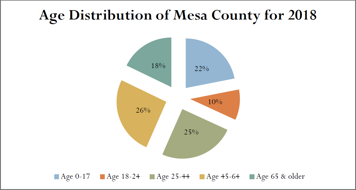
(U.S. Census Bureau)
Mesa County is served by U.S. Highways 6, 24, and 50; Interstate Highway 70; and several State highways. Most of the communities, including the larger ones, are located along the U.S. and Interstate highway systems. General intra-county access is provided by more than 1,300 miles of County road. The Union Pacific Railroad mainline parallels the U.S. and Interstate highways from east to west through the County, and a branch line parallels U.S. Highway 50 to the south. Limited railroad passenger service by Amtrak is provided, with the bulk of service handling freight. Bus service is available and four major airlines and several commuter-type airlines provide passenger and freight service to Grand Junction.
|
People and Income Overview (By Place of Residence) |
Value |
Rank in State |
Industry Overview (2018) (By Place of Work) |
Value |
Rank in State |
|---|---|---|---|---|---|
|
Population (2018) |
153,207 |
11 |
Covered Employment |
62,699 |
10 |
|
Growth (%) since 2010 Census |
4.4% |
36 |
Avg. wage per job |
$44,431 |
20 |
|
Households (2018) |
61,033 |
11 |
Manufacturing – % all jobs in County |
5.0% |
14 |
|
Labor Force (persons) (2018) |
76,060 |
10 |
Avg. wage per job |
$45,292 |
22 |
|
Unemployment Rate (2018) |
4.1% |
14 |
Transportation and Warehousing – % all jobs in County |
4.0% |
5 |
|
Per Capita Personal Income (2018) |
$44,935 |
37 |
Avg. wage per job |
$51,491 |
17 |
|
Median Household Income (2018) |
$51,132 |
41 |
Health Care, Social Assist. – % all jobs in County |
18.3% |
3 |
|
Poverty Rate (2018) |
14.4% |
20 |
Avg. wage per job |
$50,055 |
12 |
|
H.S. Diploma or More – % of Adults 25+ (2018) |
90.1 |
36 |
Finance and Insurance – % all jobs in County |
3.1% |
13 |
|
Bachelor’s Deg. or More – % of Adults 25+ (2018) |
27.4 |
32 |
Avg. wage per job |
$66,423 |
18 |
(U.S. Census Bureau)
(Res. 61-20, 10-7-20; Res. 32-15, 7-1-15; Res. 05-10, 1-6-10)
42.08.090 Economy.
Mesa County is showing signs of economic improvement since the steep decline that began in late 2008. Mesa County saw a six-year high in our labor force numbers at 78,379 as well as the lowest unemployment rate on record at 2.5 percent in September of 2019. Since 2015, more than 3,000 jobs have been added to our region across all industries. Currently, health care and social assistance has the highest number of jobs at 10,887, followed by government at 10,769, and retail taking the third place at 8,218. Figure 5 depicts Mesa County labor force and unemployment.
Figure 5: Mesa County Labor Force and Unemployment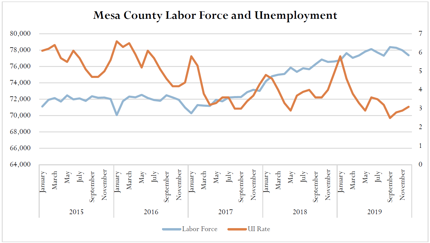
(Englehart, 2020)
(Res. 61-20, 10-7-20; Res. 32-15, 7-1-15; Res. 05-10, 1-6-10)
Article III. Planning Process
42.08.100 Planning process.
44 CFR Requirement Section 201.6(c)(1): [The plan shall document] the planning process used to develop the plan, including how it was prepared, who was involved in the process, and how the public was involved.
As a requirement under the Disaster Mitigation Act of 2000, local jurisdictions are responsible for revising their Hazard Mitigation Plans every five years. This plan is an update to the County’s 2015 Hazard Mitigation Plan that was completed in 2015 and approved in June 2015 under this requirement. All sections of the plan were analyzed and revised where appropriate as part of the update process.
(Res. 61-20, 10-7-20; Res. 32-15, 7-1-15; Res. 05-10, 1-6-10)
42.08.110 Multi-jurisdictional participation.
44 CFR Requirement Section 201.6(a)(3): Multi-jurisdictional plans may be accepted, as appropriate, as long as each jurisdiction has participated in the process and has officially adopted the plan.
Mesa County invited every incorporated city and special district in the County to participate in the multi-jurisdictional Mesa County Hazard Mitigation Planning process. The Disaster Mitigation Act requires that each jurisdiction participate in the planning process and officially adopt the multi-jurisdictional hazard mitigation plan. Each jurisdiction that chose to participate in the planning process and development of the plan was required to meet minimum plan participation requirements of attending at least one planning meeting. Participants were, however, encouraged to participate in the entire process, which included the following:
(a) Designate a representative to serve on the HMPC.
(b) Participate in HMPC meetings.
(c) Complete and return worksheets.
(d) Identify mitigation actions for the plan.
(e) Review and comment on plan drafts.
(f) Inform the public, local officials, and other interested parties about the planning process and provide opportunity for them to comment on the plan.
(g) Formally adopt the Hazard Mitigation Plan.
The following table details how jurisdictions participated in Hazard Mitigation Planning Committee meetings.
|
Meeting Date (2019/2020) |
Kickoff Meeting: September 3, 2019 |
HMPC #2: October 9, 2019 |
HMPC #3: November 13, 2019 |
HMPC Final Mtg. January 8, 2020 |
|---|---|---|---|---|
|
Mesa County |
X |
X |
X |
X |
|
City of Grand Junction |
X |
X |
X |
X |
|
City of Fruita |
X |
X |
X |
X |
|
Town of Collbran |
|
X |
|
|
|
Town of Palisade |
|
|
X |
X |
|
Town of DeBeque |
|
|
|
X |
|
Lower Valley FPD |
X |
X |
|
|
|
Plateau Valley FPD |
X |
|
X |
X |
|
Grand Junction Rural Fire |
X |
X |
X |
|
|
Clifton FPD |
X |
X |
X |
|
|
DeBeque FPD |
X |
|
|
X |
(Res. 61-20, 10-7-20; Res. 32-15, 7-1-15; Res. 05-10, 1-6-10)
42.08.120 Ten-step planning process.
Mesa County used FEMA’s Local Mitigation Planning Handbook (2013). The process used by Mesa County meets the funding eligibility requirements of the Hazard Mitigation Grant Program, Building Resilient Infrastructure and Communities Program, Community Rating System, and Flood Mitigation Assistance program. This plan is structured around a four-phase approach; organize resources, assess risks, develop the mitigation plan, and implement the plan and monitor progress.
(Res. 61-20, 10-7-20; Res. 32-15, 7-1-15; Res. 05-10, 1-6-10)
42.08.130 Phase 1 – Organize resources.
(a) Step 1: Organize the Planning Effort. Mesa County’s Hazard Mitigation Planning effort started with a kick-off meeting on September 3, 2019. The Mesa County Emergency Management Department mailed letters to County, municipal, district, State, and federal stakeholder representatives inviting representatives to attend the September 3rd meeting and participate in the process. This list is located in Appendix B.
A planning committee was created that includes representatives from each participating jurisdiction, departments of the County, and other local, State, and federal agencies responsible for making decisions in the plan. Representatives at the kick-off meeting agreed to act as the Hazard Mitigation Planning Committee (HMPC).
The following agency representatives participated in the HMPC:
|
Bill Barlow |
Grand Valley Power |
|
Christmas Wharton |
Grand Valley Power |
|
Brian Woods |
Clifton Sanitation |
|
Eli Jennings |
Clifton Sanitation |
|
Carrie Gudorf |
Mesa County (Engineering) |
|
Gus Hendricks |
Grand Junction Rural Fire Protection District (Fire Department) |
|
David Reinertsen |
Clifton Water |
|
Paula Creasy |
Grand Junction Regional Communications Center |
|
William Baker |
City of Grand Junction (Police Department) |
|
Trent Prall |
City of Grand Junction |
|
Richard Rupp |
Town of Palisade (Fire Department) |
|
Dave Krause |
City of Fruita (Police Department) |
|
Dave Payne |
Ute Water District |
|
Kamie Long |
Colorado State Forest Service |
|
Mike Harvey |
DeBeque Fire Protection District |
|
Aldis Strautins |
National Weather Service |
|
Vincent Burkhardt |
Mesa County (Public Health) |
|
Matt Ozanic |
Colorado State Patrol |
|
Jeff Colton |
National Weather Service |
|
Andy Martsolf |
Mesa County Office of Emergency Management |
|
Chris Kadel |
Mesa County (GIS) |
|
Bob Dalley |
Town of DeBeque (Town Marshal) |
|
Frank Cavaliere |
Lower Valley Fire Protection District |
|
Ryan Davison |
Mesa County (GIS) |
|
Mike Lockwood |
Plateau Valley Fire Protection District |
|
Patrick Cole |
DeBeque Fire Protection District |
|
Mark Krebs |
Colorado National Monument |
|
Eric Paul |
Colorado National Monument |
|
Patricia Gavelda |
Colorado Division of Homeland Security and Emergency Management |
|
Charles Balke |
Clifton Fire Protection District |
|
Joe White |
Clifton Fire Protection District |
|
Care’ McInnis |
Town of DeBeque |
|
Montana Cohn |
Mesa County Weed and Pest |
|
Bill Edwards |
U.S. Forest Service |
|
Dan Love |
Colorado Department of Agriculture |
|
Ed Kline |
Colorado Department of Agriculture |
|
Dave Wolny |
Colorado Mesa University |
|
Nick Peck |
Fruita Police Department |
|
Darren Starr |
City of Grand Junction |
|
Janet Hawkinson |
Town of Palisade |
|
Troy Ward |
Town of Palisade |
|
Melonie Matarozzo |
Town of Collbran |
The role of the HMPC was to collect data, make decisions on plan process and content, submit mitigation action implementation worksheets, review plan drafts, and coordinate and assist with community meetings and plan adoptions.
Four meetings were held with the Hazard Mitigation Planning Committee to gather data, develop mitigation actions, and review the draft plan. The agendas, sign-in sheets, and sample worksheets used to collect data are included in Appendix D.
|
Meeting |
Topic |
Date |
|---|---|---|
|
Kick-off Meeting |
Introduction of planning process and discussion of hazards |
September 3, 2019 |
|
HMPC #2 |
Review of risk assessment, identification of goals and objectives |
October 9, 2019 |
|
HMPC #3 |
Identification and prioritization of mitigation actions, discussion of process to monitor, evaluate, and update plan |
November 13, 2019 |
|
HMPC #4 |
Review of updated plan and final planning |
January 8, 2020 |
During the kick-off meeting, Mesa County Emergency Management staff presented information on the scope and purpose of the plan, participation requirements of HMPC members, and the proposed project work plan and schedule. Also discussed were the hazard identification requirements and data. Table 4 shows the analysis of hazards in Mesa County. This table is based on past events, impacts and future probability for each of the hazards required by FEMA for consideration in a local hazard mitigation plan. Emergency Management staff refined the list of hazards relevant to Mesa County.
|
Hazard Type |
Geographic Location |
Occurrences |
Magnitude/Severity |
Total Score |
Hazard Level |
|---|---|---|---|---|---|
|
Avalanche |
2 |
4 |
6 |
32 |
M |
|
Drought |
8 |
4 |
4 |
48 |
M |
|
Earthquake |
6 |
4 |
4 |
40 |
M |
|
Expansive Soils |
2 |
4 |
2 |
16 |
L |
|
Extreme Heat |
8 |
4 |
2 |
40 |
M |
|
Wildfire |
6 |
8 |
4 |
80 |
H |
|
Flood |
6 |
8 |
6 |
96 |
H |
|
Hailstorm |
4 |
4 |
2 |
24 |
L |
|
Land Subsidence |
2 |
4 |
4 |
24 |
L |
|
Landslide/Rockfall |
4 |
8 |
6 |
80 |
H |
|
Lightning |
2 |
8 |
4 |
48 |
M |
|
Tornado |
2 |
4 |
2 |
16 |
L |
|
Windstorm |
4 |
6 |
4 |
48 |
M |
|
Winter Storm |
6 |
6 |
2 |
48 |
M |
|
Dam Failure |
4 |
4 |
6 |
40 |
M |
|
Hazardous Materials |
2 |
8 |
4 |
48 |
M |
|
Geographic Location |
|
|---|---|
|
Large: greater than 50% |
8 |
|
Medium: 25 – 50% |
6 |
|
Small: 10 – 25% |
4 |
|
Isolated: less than 10% |
2 |
|
Magnitude/Severity |
|
|---|---|
|
Catastrophic: |
8 |
|
Critical: |
6 |
|
Limited: |
4 |
|
Negligible: |
2 |
|
Occurrence |
|
|---|---|
|
Highly Likely: |
8 |
|
Likely: |
6 |
|
Occasional: |
4 |
|
Unlikely: |
2 |
|
Formula: Total Score = Occurrences x (Geographic Location + Magnitude/Severity) |
|
Hazard Level is based on Total Score. |
|
Total Score: |
|
L = 8 – 28 |
|
M = 32– 64 |
|
H = 72 – 128 |
HMPC representatives were given several worksheets to begin the data collection process. A brief description of each worksheet is provided below and a sample of each worksheet is located in Appendix E.
Worksheet #1 is the Historical Hazard Event Data Collection Sheet which is used to gather historical events that have occurred in Mesa County.
Worksheet #2 is the Vulnerability worksheet used to determine the vulnerable populations, buildings, critical facilities, and infrastructure for each hazard that affects our jurisdiction. For this specific exercise, Mesa County made the decision to focus on the top three hazards affecting our County, which include wildfires, floods, and rockfalls. This particular information was used to estimate disaster losses which can then be used to gauge potential benefits of mitigation measures.
Worksheet #3 is the Capabilities Matrix which is filled out by each participating jurisdiction identifying various capabilities that exist with each entity.
Worksheet #4, the Mitigation Strategy worksheet, is used to identify possible mitigation actions.
Worksheet #5 is the actual Mitigation Project Description. This worksheet is used to develop mitigation projects identified during the planning process and provide additional details about the project.
(b) Step 2: Public Involvement.
44 CFR Requirement Section 201.6(b): An open public involvement process is essential to the development of an effective plan. In order to develop a more comprehensive approach to reducing the effects of natural disasters, the planning process shall include: (1) an opportunity for the public to comment on the plan during the drafting stage and prior to plan approval.
The HMPC posted the draft plan on the County’s website and utilized a public information campaign to invite participation into the planning process. The committee used a press release, media interviews, multiple blogs, Facebook, Twitter, Instagram, and Next Door. The goal of the campaign was to invite the public to review and comment on the plan and to complete a hazard perception survey.
Using analytics software, the committee was able to determine that the campaign had the following reach:
• Facebook: 65,862 followers
• Twitter: 7,307 followers
• Next Door: 18,962 residents
• Blogs: 817 subscribers
• TV broadcast media: 63,382 viewers
• Print media: 62.2 percent of Mesa County adults
The HMPC received 113 survey responses. Complete survey results are included in Appendix H. Survey highlights include:
(1) Prior to participating in the survey, 24.5 percent of survey respondents were aware of the Hazard Mitigation Plan.
(2) In the past five years, 25 percent of survey respondents (or someone in their household) have been impacted by a natural hazard event.
(3) The most common hazard events experienced by survey respondents are: windstorm, drought, and wildfire.
(4) Survey respondents are most concerned about: drought (97 respondents), wildfire (94 respondents, and extreme heat (86 respondents).
(5) More than 47 percent of survey respondents have received information about how to make their households safer from natural disasters.
(6) Survey respondents were most likely to receive information about how to make their homes safer from natural disasters from: government agencies (18.3 percent), insurance company (16.7 percent), and news media (16.7 percent).
(c) Step 3: Departments and Agencies Coordination.
44 CFR Requirement Section 201.6(b): An open public involvement process is essential to the development of an effective plan. In order to develop a more comprehensive approach to reducing the effects of natural disasters, the planning process shall include: (2) An opportunity for neighboring communities, local and regional agencies involved in hazard mitigation activities, and agencies that have the authority to regulate development, as well as businesses, academia and other private and nonprofit interests to be involved in the planning process; (3) Review and incorporation, if appropriate, of existing plans, studies, reports, and technical information.
There are numerous organizations whose goals and interests align with hazard mitigation in Mesa County. Coordination with these organizations and other community planning efforts is vital to the success of this plan. The Mesa County Office of Emergency Management invited other local, State, and federal departments to participate in this process with several of them serving as representatives on the HMPC. As a component of the coordination with other agencies, the HMPC collected and reviewed existing technical data, reports, and plans. State and federal agency data sources, including the National Weather Service and the Flash Flooding at the Colorado National Monument (1921-2003) Report produced by Professor Gigi Richard of Mesa State were used to collect information.
Mesa County and the participating communities also used a variety of comprehensive planning mechanisms, such as land use and general plans, emergency operations plans, and municipal ordinances and building codes as references. This information was used in the development of the hazard identification, vulnerability assessment, and capability assessment and in the formation of goals, objectives, and mitigation actions.
Emergency managers in the neighboring jurisdictions of Garfield County, Pitkin County, Delta County, and Montrose Counties were sent an email invitation to review and provide comments on the draft 2020 Mesa County plan which was posted on a County website. A copy of the email is included in Appendix G.
(Res. 61-20, 10-7-20; Res. 32-15, 7-1-15; Senate Bill 11-265, 6-6-11; Res. 05-10, 1-6-10)
42.08.140 Phase 2 – Assess risk.
(a) Step 4: Identify the Hazards. During the kick-off meeting, the HMPC discussed past events, impacts, and future probability for each of the hazards required by FEMA for consideration in a local hazard mitigation plan. A profile of each hazard was then developed with the help of County GIS staff in developing GIS layers to display the information. The HMPC discussed the rankings as determined by the scores associated with each of the factors, i.e., occurrences, probability of future occurrences, magnitude and severity. The committee concurred with the scoring and the ratings of hazards as either high, medium, or low hazards. The committee then determined the areas affected by the top three hazards and GIS mapped out the areas using a subjective boundary.
(b) Step 5: Assess the Risks. After profiling the hazards that could impact Mesa County, the Emergency Management Department staff collected information to describe the likely impacts of future hazard events in the participating jurisdictions. This step involved two parts: a vulnerability assessment and a capability assessment.
The vulnerability assessment involves an inventory of assets at risk to natural hazards and in particular wildfires, flooding, and rock fall/landslides. These assets included total number and value of structures; critical facilities and infrastructure; natural, historic and cultural assets; and economic assets. Mesa County Emergency Management staff completed detailed analysis for each community participating in this revision of the plan. The analysis was used to determine the proportion of value of buildings in the hazard areas that were identified by the HMPC. The County GIS system was used by first selecting parcels from the Assessor’s data that have their center within the City or Town limits and then making a subselection of parcels that have their center within the defined hazard area. Structure value is based on the actual value of improvements.
A similar process was completed for each jurisdiction to understand the affected population. This analysis used census tract data in the GIS system.
The capability assessment consists of identifying the existing mitigation capabilities of participating jurisdictions. This includes government programs, policies, regulations, ordinances, and plans that mitigate or could be used to mitigate risk to disasters. Participating jurisdictions collected information on their regulatory, personnel, fiscal, and technical capabilities as well as ongoing initiatives related to interagency coordination and public outreach. This information is included in Appendix E.
(Res. 61-20, 10-7-20; Res. 32-15, 7-1-15; Res. 05-10, 1-6-10)
42.08.150 Phase 3 – Develop the mitigation plan.
(a) Step 6: Set Goals. The HMPC divided themselves into three groups with each group assigned to develop mitigation goals to one of the three “high” hazards. The groups identified possible locations and possible actions that could be integrated into existing planning.
(b) Step 7: Review Possible Activities. At the third committee meeting, the HMPC identified and prioritized mitigation actions. The HMPC conducted a brainstorming session in which each committee member identified at least one mitigation action to address each of the plan’s goals.
As with each priority, there is a responsible agency to ensure the project is completed. The HMPC identified the responsible agency for implementing each action. The responsible agency then completed the Mitigation Project Description Worksheet (worksheet #5). These worksheets allow the HMPC to document background information, ideas for implementation, alternatives, responsible agency, partners, potential funding, cost estimates, benefits, and timeline for each identified action.
(c) Step 8: Draft the Plan. A draft of the revised Mesa County Multi-Hazard Mitigation Plan was developed by Mesa County Department of Emergency Management staff and submitted to the HMPC for internal review. Once the committee’s comments were incorporated, a complete draft of the plan was made available online for review and comment by the public and other agencies and interested stakeholders. The review period was from July 1, 2020, to July 15, 2020. Public comments were integrated into a final draft for submittal to the Colorado Division of Homeland Security and Emergency Management and FEMA Region VIII.
(Res. 61-20, 10-7-20; Res. 32-15, 7-1-15; Res. 05-10, 1-6-10)
42.08.160 Phase 4 – Implement the plan and monitor progress.
(a) Step 9: Adopt the Plan. To implement the plan, the governing bodies of each participating jurisdiction adopted the plan with a formal resolution. Scanned copies of resolutions of adoption are included in Appendix A.
(b) Step 10: Implement, Evaluate, and Revise the Plan. The HMPC developed and agreed upon on overall strategy for plan implementation and for monitoring and maintaining the plan over time. This strategy is further described in the plan implementation article.
(Res. 61-20, 10-7-20; Res. 32-15, 7-1-15; Res. 05-10, 1-6-10)
Article IV. Risk Assessment
42.08.170 Risk assessment.
Requirement Section 201.6(c)(2): [The plan shall include] a risk assessment that provides the factual basis for activities proposed in the strategy to reduce losses from identified hazards. Local risk assessments must provide sufficient information to enable the jurisdiction to identify and prioritize appropriate mitigation actions to reduce losses from identified hazards.
Risk to natural hazards is a combination of hazard, vulnerability, and capability. The risk assessment process identifies and profiles relevant hazards and assesses the exposure of lives, property, and infrastructure to these hazards. The goal of the risk assessment is to estimate the potential loss in Mesa County, including loss of life, personal injury, property damage, and economic loss, from a hazard event. The risk assessment process allows communities in Mesa County to better understand their potential risk to natural hazards and provides a framework for developing and prioritizing mitigation actions to reduce risk from future hazard events.
The risk assessment for Mesa County and its jurisdictions followed the methodology described in the FEMA publication Local Mitigation Planning Handbook (2013), which includes a four-step process:
(a) Identify hazards;
(b) Profile hazard events;
(c) Inventory assets;
(d) Estimate losses.
This article is divided into three parts: hazard identification, hazard profiles, and vulnerability assessments.
(Res. 61-20, 10-7-20; Res. 32-15, 7-1-15; Res. 05-10, 1-6-10)
42.08.180 Hazard identification.
Requirement Section 201.6(c)(2)(i): [The risk assessment shall include a] description of the type … of all natural hazards that can affect the jurisdiction.
The Mesa County Hazard Mitigation Planning Committee (HMPC) reviewed data and discussed the impacts of each of the hazards required by FEMA for consideration, which are listed below, to determine the hazards that threaten Mesa County and its jurisdictions:
|
Avalanche |
Expansive Soils |
Landslide |
Windstorm |
|
Coastal Erosion |
Extreme Heat |
Severe Winter Storm |
|
|
Coastal Storm |
Flood |
Tornado |
|
|
Dam/Levee Failure |
Hailstorm |
Tsunami |
|
|
Drought |
Hurricane |
Volcano |
|
|
Earthquake |
Land Subsidence |
Wildfire |
|
Data on past impacts and future probability of these hazards was collected from the following sources:
|
State of Colorado Natural Hazard Mitigation Plan (2018) |
|
Mesa County Hazard Mitigation Plan (2015) |
|
Spatial Hazard Event and Loss Database (SHELDUS), a component of the University of South Carolina Hazards Research Lab |
|
National Oceanic and Atmospheric Administration’s (NOAA) National Climatic Data Center |
|
Disaster declaration history from FEMA, the Public Entity Risk Institute, and the U.S. Department of Agriculture (USDA) Farm Service Agency |
The HMPC eliminated some hazards from further analysis because they do not occur in Mesa County or their impacts were not considered significant in relation to other hazards. Table 5 lists these hazards and the reasoning for their removal from consideration.
|
Hazard |
Explanation for Removal from Plan |
|---|---|
|
Coastal Erosion |
Mesa County is not near coastal area. |
|
Coastal Storm |
Mesa County is not near coastal area. |
|
Hailstorm |
Hailstorms occur, but large-sized damaging hail is rare. Past damage has been negligible. |
|
Hurricane |
Mesa County is not near coastal area. |
|
Tsunami |
Mesa County is not near coastal area. |
|
Volcano |
Dotsero, near Glenwood Canyon, is the only volcano of concern in Colorado. It has not erupted in 4,000 years. |
The HMPC identified 13 natural hazards that could affect Mesa County and other jurisdictions. These hazards are profiled in further detail throughout this plan. Although not required by the Disaster Mitigation Act of 2000, the HMPC decided to address one manmade hazard – hazardous materials release. The risk from this hazard is related primarily to the transportation of hazardous materials through the County or from a release generated at any one of the number of facilities that produces or stores chemicals on site.
(Res. 61-20, 10-7-20; Res. 32-15, 7-1-15; Res. 05-10, 1-6-10)
42.08.190 Disaster declaration history.
Mesa County has received the following disaster declarations:
|
Year |
Type of Declaration |
Hazard |
|---|---|---|
|
1984 |
Presidential |
Flooding |
|
1995 |
State |
Flooding |
|
2002 |
Presidential |
Wildfires |
|
2002 |
USDA Disaster |
Drought |
|
2006 |
USDA Disaster |
Drought |
|
2012 |
State |
Wildfire |
|
2012 |
USDA Disaster |
Drought |
|
2012 |
USDA Disaster |
Crop |
|
2013 |
USDA Disaster |
Crop |
|
2014 |
USDA Disaster |
Drought |
|
2014 |
USDA Disaster |
Crop |
|
2014 |
Local/State |
Landslide |
|
2015 |
USDA Disaster |
Drought |
|
2015 |
USDA Disaster |
Severe Freeze |
|
2017 |
USDA Disaster |
Severe Freeze |
|
2018 |
USDA Disaster |
Drought |
|
2019 |
USDA Disaster |
Drought |
|
2020 |
Local/State/Federal |
Pandemic |
(Res. 61-20, 10-7-20; Res. 32-15, 7-1-15; Res. 05-10, 1-6-10)
42.08.200 Hazard profiles.
Requirement Section 201.6(c)(2)(i): [The risk assessment shall include a] description of the … location and extent of all natural hazards that can affect the jurisdiction. The plan shall include information on previous occurrences of hazard events and on the probability of future hazard events.
Requirement Section 201.6(c)(2)(ii): [The risk assessment shall include a] description of the jurisdiction’s vulnerability to the hazards described in paragraph (c)(2)(i) of this section. The description shall include an overall summary of each hazard and its impact on the community.
The hazards identified in this section are profiled individually and a summary of the probability of future occurrence and potential magnitude is provided. Each hazard was also given an overall rating of High – Medium – Low based on the score it received by using the following formula:
Total Score = Occurrences x Impacts (Occurrences x [Geographic Location + Magnitude/Severity])
Detailed profiles for each of the identified hazards include the following information:
(a) Hazard Description. This section consists of a general description of the hazard and the general impacts it may have on a community.
(b) Geographic Location. This section describes the geographic extent or location of the hazard in the planning area and identifies the affected area as isolated, small, medium, or large.
(1) Large (8) – Greater than 50 percent of the County affected.
(2) Medium (6) – 25 to 50 percent of the County affected.
(3) Small (4) – 10 to 25 percent of the County affected.
(4) Isolated (2) – Less than 10 percent of the County affected.
(c) Occurrence. This section includes information on historic incidents, including impacts and costs, if known. A historic incident worksheet (worksheet #1) was used to capture the incident information from participating jurisdictions.
(d) Future Occurrence. The frequency of past events is used to gauge the likelihood of future occurrences. Based on historical data, the probability of future occurrence is categorized as follows and given a corresponding score:
(1) Highly Likely: (8). Near 100 percent chance of occurrence next year or happens every year.
(2) Likely: (6). Ten to 100 percent chance of occurrence in next year or has a recurrence interval of 10 years or less.
(3) Occasional: (4). One to 10 percent chance of occurrence in the next year or has a recurrence interval of 11 to 100 years.
(4) Unlikely: (2). Less than one percent chance of occurrence in next 100 years or has a recurrence interval of greater than every 100 years.
The probability, or chance of occurrence, was calculated where possible based on existing data.
(e) Magnitude/Severity. This section summarizes the magnitude/severity or extent of hazard event in terms of deaths, injuries, property damage, and interruption of essential facilities and services. Magnitude and severity is classified in the following manner and given a corresponding score:
(1) Catastrophic (8). Multiple deaths; property destroyed and severely damaged; and/or interruption of essential facilities and service for more than 72 hours.
(2) Critical (6). Isolated deaths and/or multiple injuries and illnesses; major or long-term property damage that threatens structural stability; and/or interruption of essential facilities and services for 24 to 72 hours.
(3) Limited (4). Minor injuries and illnesses; minimal property damage that does not threaten structural stability; and/or interruption of essential facilities and services for less than 24 hours.
(4) Negligible (2). No or few injuries or illnesses; minor quality of life loss; little or no property damage; and/or brief interruption of essential facilities or services.
(f) Impact of a Changing Climate. According to the 2018 National Climate Assessment a changing climate would create new risks and exacerbate existing vulnerabilities in communities across the United States (U.S.), presenting growing challenges to human health and safety, quality of life, and the rate of economic growth. This could include more frequent and intense extreme weather and climate-related events, as well as changes in average climate conditions, which could continue to damage infrastructure, ecosystems, and social systems. The U.S. Environmental Protection Agency (EPA) concludes that a world of warmer temperatures could lead to less predictable weather patterns and rising sea levels. While impacts within and across regions may not be distributed equally, these and other impacts would threaten the reliable delivery of many community services. Although extreme weather events are caused by a variety of contributing factors, human-induced climate change is considered by a large majority of the scientific community to be one of those contributing factors.
The 2018 National Climate Assessment found that temperatures increased across almost all of the Southwest U.S. from 1901 to 2016 with the greatest increases in southern California and western Colorado. If this trend were to continue, the increase in heat and reduction of snow under a changing climate would tend to increase the duration and severity of droughts. Additionally, this could contribute to aridification (a potentially permanent change to a drier environment) through lower soil moisture, reduced snow cover and changes in the timing and efficiency of snowmelt and runoff.
The 2018 National Climate Assessment also estimated that the area burned by wildfire across the western U.S. from 1984 to 2015 was twice what would have been burned had the climate not been changing. Some of the worst wildfires in Colorado State history have occurred within the last 10 years, including the Black Forest Fire in 2013, Spring Creek Fire in 2018, and the 416 Fire in 2018.
A changing climate in Mesa County will likely induce longer summertime warm periods, earlier onset of spring snowmelt, more precipitation arriving as rain rather than snow, and longer dry periods with heavier precipitation events in between. These types of changes could exacerbate already risky wildfire conditions, place extra pressure on already stretched water providers and users, provide additional challenges to winter and summer recreation providers, as well as a decline in snowpack depth and duration which is closely linked to water availability, watershed functions and winter ecology impacting every sector important to the community.
(Res. 61-20, 10-7-20; Res. 32-15, 7-1-15; Res. 05-10, 1-6-10)
42.08.210 Avalanche.
Avalanche hazards occur mostly in mountainous regions of Colorado above 8,000 feet. The vast majority of avalanches occur during and shortly after winter storms. Avalanches occur when loading of new snow increases stress at a rate faster than strength develops, and the slope fails. While most avalanches are caused by the weight of accumulated snow, other triggers can be caused by human activities (e.g., skier, snowshoer, and snowmobiler).
(a) Geographic Location. The geographic extent of this hazard in Mesa County is isolated – less than 10 percent of the County is affected.
The avalanches in Mesa County have primarily occurred on the Grand Mesa which is primarily federally owned land.
(b) Previous Occurrences. According to the National Climatic Data Center Storm Events Database and the CAIC information, Mesa County has had five recorded avalanches from 1959 to 2019.
(1) January 30, 1999 – Nine snowmobilers were traversing the north side of the Grand Mesa at the 10,600-foot level. The snowmobiler who was third in line triggered a small hard-slab avalanche which buried him under five feet of snow ending with unsuccessful resuscitation efforts.
(2) February 24, 2002 – A snowmobiler triggered a soft-slab avalanche near Flat Top Mountain in extreme northeast Mesa County, about eight miles south southwest of Sunlight Ski Area. This avalanche was about 300 feet across and two feet deep, beginning at an elevation of just below the 10,200-foot level. The avalanche ran approximately 400 vertical feet. The victim was found after having been buried for approximately 30 minutes. Resuscitation efforts were unsuccessful.
(3) February 4, 2004 – Avalanche swept across Highway 65 at mile marker 36 on the Grand Mesa. One vehicle was buried and the road was closed in both directions until the next day. No injuries or fatalities reported; however, $5,000 in property damage was reported.
(4) April 1, 2005 – A backcountry skier was killed when he triggered an avalanche at about 10,560 feet above sea level on the Grand Mesa while ascending a slope. The skier was swept over some rocks and down into some trees. His companion notified 911 dispatch of the incident. CDOT employees and Mesa County Search and Rescue responded and found the victim approximately two hours after he was buried.
(5) March 17, 2010 – Two cross country skiers attempted to ski the Thunderbird area on the west side of the Grand Mesa. The skiers were passing through a clearing when a wall of snow above them collapsed. They were both carried an estimated 300 to 800 feet down slope. One of the skiers was dragged into several trees and seriously injured. Mesa County Search and Rescue responded and the injured skier was airlifted to the regional trauma center.
(c) Probability of Future Occurrence. The probability of future occurrence for avalanches in Mesa County is considered occasional or a one to 10 percent chance of happening in the next year.
(d) Magnitude/Severity. Three out of the four avalanche events recorded resulted in a death, categorizing the magnitude/severity of this hazard as critical.
(Res. 61-20, 10-7-20; Res. 32-15, 7-1-15; Res. 05-10, 1-6-10)
42.08.220 Dam failure.
(a) Hazard Description. Dams are manmade structures built for a variety of uses, including flood protection, power, agriculture, water supply, and recreation. Dams typically are constructed of earth, rock, concrete, or mine tailings. Two factors that influence the potential severity of a full or partial dam failure are the amount of water impounded and the density, type, and value of development and infrastructure located downstream.
Dam failures can result from any one or a combination of the following causes:
(1) Prolonged periods of rainfall and flooding, which result in overtopping (overtopping is the primary cause of earthen dam failure);
(2) Earthquake;
(3) Inadequate spillway capacity resulting in excess overtopping flows;
(4) Internal erosion caused by embankment or foundation leakage or piping or rodent activity;
(5) Improper design;
(6) Improper maintenance;
(7) Negligent operation;
(8) Failure of upstream dams on the same waterway.
(b) Geographic Location. The geographic extent of this hazard in Mesa County is small – 10 to 25 percent of the County is affected.
The Colorado Division of Water Resources provided a list of dams in Mesa County as shown in Table 6 and their classification based on the potential hazard to the downstream area resulting from failure of the dam:
(1) Class I (High Hazard): Failure of dam would likely result in loss of life.
(2) Class II (Significant Hazard): Failure of dam would not cause loss of life, but would cause extensive and/or severe property damage.
Based on these classifications, there are 23 high hazard dams and 28 significant hazard dams in Mesa County. High and significant hazard dams all have emergency action plans in place.
|
Dam Name |
Hazard Class |
Year Completed |
|---|---|---|
|
ALSBURY |
1 |
1996 |
|
BIG CREEK #1 |
1 |
1893 |
|
BIG CREEK #3 |
1 |
1893 |
|
BONHAM-WELLS |
1 |
1900 |
|
BULL CREEK #4 |
1 |
1901 |
|
COON CREEK #1 |
1 |
1900 |
|
COTTONWOOD #1 |
1 |
1894 |
|
COTTONWOOD #2 |
1 |
1895 |
|
COTTONWOOD #5 |
1 |
1909 |
|
HALLENBECK #1 |
1 |
1970 |
|
INDIAN WASH DET. |
1 |
1965 |
|
JERRY CREEK #1 |
1 |
1964 |
|
JERRY CREEK #2 |
1 |
1978 |
|
JERRY CREEK DIKE 1 |
1 |
1978 |
|
JUNIATA |
1 |
1979 |
|
KITSON |
1 |
1911 |
|
LEON LAKE |
1 |
1898 |
|
PARKER BASIN #1 |
1 |
1899 |
|
PARKER BASIN #3 |
1 |
1899 |
|
SOMERVILLE-McCULLAH |
1 |
1972 |
|
UPPER HIGHLINE |
1 |
1967 |
|
VEGA |
1 |
1959 |
|
Y T RANCH |
1 |
1911 |
|
ANDERSON #1 |
2 |
1963 |
|
ANDERSON #2 |
2 |
1974 |
|
BIG BEAVER |
2 |
1947 |
|
BOLEN |
2 |
1973 |
|
BULL BASIN #2 |
2 |
1953 |
|
BULL CREEK #5 |
2 |
1901 |
|
CASTO |
2 |
1940 |
|
COLBY HORSE PARK |
2 |
1956 |
|
COTTONWOOD #4 |
2 |
1896 |
|
CRAIG #1 |
2 |
1951 |
|
CRAIG #2 |
2 |
1960 |
|
DEEP CREEK #2 |
2 |
1906 |
|
FLOWING PARK |
2 |
1973 |
|
FRUITA #1 |
2 |
1949 |
|
FRUITA #2 |
2 |
1959 |
|
GARDNER LAKE |
2 |
1980 |
|
GOBBO #1 |
2 |
1973 |
|
GOBBO #3 |
2 |
1973 |
|
GRAND MESA #1 |
2 |
1887 |
|
GRAND MESA #8 |
2 |
1901 |
|
HALLENBECK #2 |
2 |
1943 |
|
HOGCHUTE |
2 |
1947 |
|
MESA CREEK #1 |
2 |
1893 |
|
MESA CREEK #3 |
2 |
1890 |
|
MESA CREEK #4 |
2 |
1892 |
|
MONUMENT #1 |
2 |
1960 |
|
PALISADE CABIN |
2 |
1956 |
|
RAPID CREEK #1 |
2 |
1934 |
Figure 6 is a map showing locations of the Class I and II Dams in Mesa County.
Figure 6: Map of Dams in Mesa County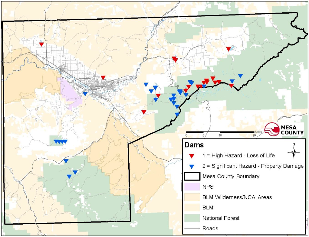
(Mesa County GIS)
(c) Previous Occurrences.
(1) June 1983 – Grand Mesa Dam No. 8 overtopped and failed during spring runoff due to emergency spillway being blocked by snow and ice. Snowmelt produced high inflow to the reservoir which overtopped dam. Minor flooding downstream with damage to Highway 65 and Lands End Road. Significant damage was reported to the dam. Dam was repaired and spillway enlarged.
(2) Spring 1998 – Fruita No. 1 dam located at the head of North East Creek south of Glade Park failed as a result of failing downstream slope. This slope failed on two separate occasions; reservoir level was restricted until dam was rehabilitated in 2009. Because this failure happened during normal operations, actual flooding was prevented.
(3) 1996 – Upper Highline Dam in unincorporated Mesa County (Mack) suffered settling and deformation of the dam. The dam crest settled several feet at the west end and reservoir was drained so dam could be rehabilitated. This intervention prevented failure and flooding. Significant damage reported to State-owned dam.
(4) 1983 – Vincient No. 2 dam (above the Town of Palisade) overtopped during spring runoff and failed. When a hazard classification is given to a dam, it is done so based on the consequences of the dam’s failure absent flooding conditions, i.e., on a clear day in summer with the stream at a “normal” level. When Vincient No. 2 failed, the stream below was running bank-full from snowmelt and the resulting failure discharge jumped out of the channel and did more damage downstream than would have normally occurred. It is important to remember that a low hazard dam can still cause a significant amount of damage and possibly result in loss of life, depending on the timing of the failure. (Jackson, 2009)
(d) Probability of Future Occurrence. The probability of future occurrence is occasional, meaning there is a one to 10 percent chance of occurrence in the next year or has a recurrence interval of 11 to 100 years. Due to the documented cases above, there is a possibility of future dam failures.
(e) Magnitude/Severity. Depending on the hazard class of the dam, the magnitude/severity of a dam failure is listed as catastrophic. Multiple deaths, destroyed or severely damaged property, and/or interruption of essential facilities and services is possible. As indicated above, Mesa County has several Class I (High Hazard) dams which would cause loss of life upon failure of the dam.
(Res. 61-20, 10-7-20; Res. 32-15, 7-1-15; Res. 05-10, 1-6-10)
42.08.230 Drought.
(a) Hazard Description. Drought is a normal, recurrent feature of climate, although some consider it a rare and random event. It occurs in virtually all climatic zones, but characteristics vary significantly from one region to another. It originates from a deficiency of precipitation over an extended period of time, usually a season or more. (University of Nebraska Lincoln, 2009)
Due to Colorado’s semiarid conditions, drought is a natural but unpredictable occurrence in the State. The onset of drought in western Colorado counties is usually signaled by a lack of significant winter snowfall.
(b) Geographic Location. The geographic location of this hazard is considered large in Mesa County, with more than 50 percent of the County affected.
(c) Previous Occurrence. According to the National Climatic Data Center, Mesa County and respective towns and municipalities have experienced several drought periods over time. Since 1999 Mesa County was experiencing multi-year drought conditions and beginning in May of 2002, western Colorado was experiencing its first full month of severe to extreme drought conditions. The most intense drought classification, exceptional drought conditions, had developed. Low elevation snowpack had already melted throughout the area and many seasonal streams dried up by the end of May.
The drought began to have a major impact on agricultural interest and to a lesser degree on the outdoor recreational industry. Perhaps of most importance, the drought created a large potential for major wildfires. Below is a list of drought occurrences as recorded by the National Climatic Data Center.
(1) May 2002 – May was the first full month of severe to extreme drought conditions in western Colorado. The most intense drought classification, exceptional drought conditions, had developed in the southwest corner of the State by the end of the month. Low elevation snowpack had already melted throughout the area before May, with many seasonal streams dried up by the end of May. In May, the drought began to have a major impact on agricultural interests, and to a lesser degree on the outdoor recreation industry. Perhaps of most importance, the drought created a large potential for major wildfires.
(2) July 2003 – Severe to extreme drought conditions continued across western Colorado during the month. Although monsoon moisture did bring thunderstorms to the area, significant rainfall amounts were not widespread in coverage. Additionally, record high temperatures occurred through much of the month.
(3) July 2004 – Surges of subtropical moisture in monsoonal flow resulted in a few bouts of widespread precipitation across western Colorado during the month, with locally heavy rains occurring in some areas. However, this had little impact on the long-term drought situation across the area, and moderate to severe drought continued across most of western Colorado.
(4) July 2005 – Occasional surges of monsoonal moisture resulted in periods of thunderstorms across western Colorado during the month of July, mainly during the second half of the month. However, typical hot conditions persisted for much of the month and the rainfall that did occur had little impact on the drought conditions across the area. Northwest Colorado remained in moderate to severe drought conditions. Although the remainder of western Colorado was no longer categorized as being in a drought, multiple years of below normal precipitation continued to cause water supply concerns.
(5) March 2007 – Below normal precipitation through the month caused an increase in the dryness and drought conditions across western Colorado.
(6) March 2012 – Moderate drought conditions expanded westward into the upper reaches of the Grand Valley by the end of March while abnormally dry conditions remained in place across the western portion of the valley through March as precipitation remained well below normal.
(7) 2018 – Severe (D2) drought conditions began to intrude over the southern portion of Mesa County by late December 2017. Early to mid January saw the severe drought encompass the entirety of Mesa County. This persisted until the end of February when the Extreme (D3) drought conditions moved into the southern portion of Mesa County. A few storms moving through the region saw this area of extreme drought be trimmed back until it rebuilt back over the entire county by early July. Throughout the summer, several sites in Mesa County saw their record warmest temperatures or had temperatures well above normal. The Grand Junction area recorded 14 days of high temperatures at or above 100 degrees in 2018 and had 90 degrees or more 90 times throughout the year. Early September saw the Exceptional (D4) drought creep into the southeast portion of Mesa County and eventually expand over the eastern portion of the County by early October. This was a result of a dismal monsoon season with prolonged hot and dry conditions over the region. However, the drought finally improved after a few wet weeks in October which eradicated the exceptional and extreme drought conditions over Mesa County. Grand Junction had 11 consecutive days of precipitation from October 1-11, 2018 with 2.53 inches total. Additionally, Grand Junction finished as the fourth wettest October on record with 2.76 inches (1.70 inches above normal for the month). By the end of 2018, most of Mesa County was in the severe drought category. Continual gradual improvement occurred during the first few months of 2019 with all traces of the drought gone in Mesa County by mid May 2019.
(d) Probability of Future Occurrence. The probability of future occurrence is occasional, meaning there is a one to 10 percent chance of occurrence in next year or has a recurrence interval of 11 to 100 years. According to the Colorado Drought Mitigation and Response Plan, Colorado was in a drought for 48 of the past 115 years (1893 – 2007). Therefore a 42 percent chance exists that a drought will happen in Colorado in any given year. (J. Truby, January 2001)
(e) Magnitude/Severity. The magnitude/severity of drought conditions is limited. Drought impacts in Mesa County can be wide reaching: economic, environmental, and societal. The most significant impacts in Mesa County and respective jurisdictions are related to wildfire protection and agriculture. Mesa County economy consists of a number of fruit and vegetable growers who are heavily impacted by drought conditions.
(Res. 61-20, 10-7-20; Res. 32-15, 7-1-15; Res. 05-10, 1-6-10)
42.08.240 Earthquake.
(a) Hazard Description. Earthquakes are defined as the sudden release of energy occurring from the collision or shifting of crustal plates on the earth’s surface or from the fracture of stressed rock formations in that crust. The release of energy results in the earth shaking, rocking, rolling, jarring and jolting; having the potential to cause minimal to great damage. Earthquakes are measured by units of magnitude, which is a logarithmic measure of earthquake size. This means that at the same distance from the earthquake, the shaking will be 10 times as large during a magnitude 5 earthquake as it would during a magnitude 4 earthquake. (EHP Web Team, 2009)
Earthquakes can cause structural damage, injury, and loss of life, as well as damage to infrastructure networks, such as water, power, communication and transportation systems. Secondary impacts can include landslides, liquefaction, fires, and dam failure.
(b) Geographic Location. Colorado is comprised of areas with low to moderate potential for damaging earthquakes, based on research by geologists and geophysicists who specialize in seismology. There are about 90 potentially active faults that have been identified in Colorado, with documented movement within the last 1.6 million years. However, there are several thousand other faults that have been mapped in Colorado that have not been sufficiently studied to know whether they are capable of generating earthquakes or not.
It is not possible to accurately estimate the timing or location of future dangerous earthquakes in Colorado. The lack of an adequate network of seismometers in Colorado makes it difficult to detect and locate earthquakes. Moreover, the historical record is quite short (~150 years). Nevertheless, the available seismic hazard information can provide a basis for a reasoned and prudent approach to seismic safety. (Subcommittee, 1999)
Mesa County has a considerable amount of fault lines as shown in Figure 7 that are located within the County but has not recently experienced a significant earthquake event.
(c) Previous Occurrences. Many of Colorado’s earthquakes occur in mountainous regions of the State with some having been located in the western valley and plateau region. The Colorado Geological Survey has estimated that the largest earthquake possible on the Western Slope of Colorado is magnitude 6.5. This estimate is based on studies of the fault systems in western Colorado. The two largest fault systems in western Colorado are associated with the Uncompahgre Uplift and the White River Uplift.
The areas of most concern are the Uncompahgre Plateau and Paradox Valley. The Uncompahgre has the greatest potential for producing a large natural event. The Paradox Valley has the greatest potential for creating a large manmade seismic event. Below are the two significant events that have occurred in Mesa County.
(1) 1971 – 4.5 magnitude earthquake, Glade Park Fault (unincorporated Mesa County).
(2) 1975 – 4.4 magnitude earthquake northeast of Fruita, Colorado (Mesa County).
(d) Probability of Future Occurrence. The probability of future occurrence for an earthquake in Mesa County or neighboring jurisdictions is occasional resulting in a one to 10 percent chance of occurrence in the next year or has a recurrence interval of 11 to 100 years.
(e) Magnitude/Severity. The magnitude/severity of an earthquake is limited resulting in minor injuries and illnesses, minimal property damage that does not threaten structural stability and/or interruption of essential facilities and services for less than 24 hours.
Figure 7: Faults in Mesa County
Source: Mesa County GIS
(Res. 61-20, 10-7-20; Res. 32-15, 7-1-15; Res. 05-10, 1-6-10)
42.08.250 Flood.
(a) Hazard Description. Flooding has occurred repeatedly throughout Mesa County and will continue to occur. FEMA defines “flooding” as “a partial or complete inundation of normally dry land areas from (1) the overland flow of a lake, river, stream, ditch, etc.; (2) the unusual and rapid accumulation or runoff of surface waters; and (3) mudflows or the sudden collapse of shoreline land.” (www.training.fema.gov/EMIWeb/IS/IS394A/glossary-0306.doc)
Snowmelt flooding is characterized by moderate peak flows, large volume, and long duration, and is marked by a diurnal fluctuation in flow. Rainfall on melting snow may speed up the melting process and increase flood flow. General rain floods are caused by prolonged heavy rainfall over large areas and are characterized by high peak flows of moderate duration. Cloudburst floods characteristically have high peak flows, high velocities, short durations, and small volumes of runoff. (FEMA, Flood Insurance Study, Mesa County Colorado, 2009)
The area adjacent to a river channel is its floodplain. In its common usage, “floodplain” most often refers to that area that is inundated by the 100-year flood, the flood that has a one percent chance in any given year of being equaled or exceeded. Other types of floods include general rain floods, thunderstorm generated flash floods, alluvial fan floods, dam failure floods (see GJMC 42.08.220, Dam failure), and local drainage floods. The 100-year flood is the national standard to which communities regulate their floodplains through the National Flood Insurance Program.
The potential for flooding can change and increase through various land use changes. A change in environment can create localized flooding problems inside and outside of natural floodplains by altering or confining watersheds or natural drainage channels. These changes are commonly created by human activities. These changes can also occur as the result of other events such as wildfires. Wildfires create hydrophobic soils, in which the soils harden preventing rainfall from being absorbed into the ground.
FEMA also defines “flash flooding” as “flood that arises very quickly, occurring suddenly, within a short time (from minutes to less than six hours), and usually is characterized by high flow velocities. Flash floods often result from intense rainfall over a small area, usually in areas of steep terrain.” (www.training.fema.gov/EMIWeb/IS/IS394A/glossary-0306.doc)
Flooding in Mesa County is caused mainly by snowmelt in the larger drainage basins and by cloudbursts over the smaller drainage basins. However, general rainstorms constitute the principal flood hazard on Roan Creek, while general rain on snowpack creates the most hazardous conditions in the basins of Plateau and Buzzard Creek. Major floods on the Colorado and Gunnison Rivers result from rapid melting of the mountain snowpack during May, June, and July and the Dolores River experiences flooding from both snowmelt and general rainstorms.
Mesa County has received a copy of the 2012 Flood Insurance Study that covers the Town of Collbran, Town of DeBeque, City of Fruita, City of Grand Junction, Mesa County unincorporated areas, and Town of Palisade. This study has developed flood risk data for various areas of the community that will be used to establish actuarial flood insurance rates. This information will also be used by Mesa County to update existing floodplain regulations as part of the Regular Phase of the National Flood Insurance Program (NFIP), and by local and regional planners to further promote sound land use and floodplain development.
The following table details information provided by the Colorado Water Conservation Board regarding the number of active flood insurance policies in Mesa County communities in 2018. With this plan update, there remains a single repetitive loss property in Mesa County (unincorporated area) (parcel no. 2697-273-00-063) with the following claims: claim no. 1: 6/8/95 in the amount of $750; claim no. 2: 7/1/99 in the amount of $2,267; and claim no. 3: 7/10/01 in the amount of $1,973. This property is partially within the FEMA regulatory floodway and partially within the regulatory special flood hazard area.
|
Jurisdiction |
Num. Policies |
Total Coverage |
Claims since 1978 |
Total paid since 1978 |
|---|---|---|---|---|
|
Mesa County |
156 |
$39,492,000 |
38 |
$262,065 |
|
Town of Collbran |
8 |
$2,235,400 |
4 |
$15,827 |
|
City of Grand Junction |
120 |
$29,238,600 |
20 |
$228,328 |
|
City of Fruita |
10 |
$3,347,100 |
5 |
$5,047 |
|
Town of Palisade |
7 |
$1,952,700 |
2 |
$0 |
|
Town of DeBeque |
1 |
$105,000 |
0 |
$0 |
(b) Geographic Location. All streams in Mesa County are either direct or indirect tributaries of the Colorado River, which traverses the north-central and northwestern sectors. From the northern County line, the river flows southwesterly for 41 miles to its confluence with the Gunnison River, thence northwesterly 27 miles, and again southwesterly for 15 miles in its remaining course in the County.
In general, the Dolores River, Gunnison River, and West Creek systems drain the western, southwestern, and south-central portions of the County. The Plateau Creek system drains the eastern sector, except for the easternmost portion, which is drained by the Divide Creek system, which flows northerly to the Colorado River in Garfield County. A group of minor creeks and washes flowing southerly from the Roan and Bookcliffs regions drain the northwestern portion of the County, and a group of similar streamways convey drainage to the river from the north-central portion.
Plateau Creek has its headwaters in the Grand Mesa National Forest, approximately 18 miles southeast of the Town of Collbran. The stream flows northwesterly from its origin near Chalk Mountain into Vega Reservoir, approximately 11 miles upstream from Collbran. Plateau Creek then continues westerly from Vega Reservoir through Collbran to its confluence with the Colorado River.
Mesa County is subject to major stream flooding caused by rapid snowmelt, usually associated with rising temperatures and flash flooding caused by rains associated with thunderstorms. Spring runoff usually reaches its peak in June and recedes to a normal flow by mid-July. Mesa County typically experiences the monsoonal weather patterns in late July and August that create the potential for flash flood events found in the steeper drainage areas of the County. It is these events that have the greatest potential for causing major flooding in Mesa County and typically involve localized flooding and debris-flow issues.
(c) Previous Occurrences. Mesa County has a long history of flooding from summer cloudburst storms and from snowmelt runoff. Seven major flood events have occurred on the Colorado River, four on the Gunnison River, and four on the Dolores River. Floods occurred in 1884, 1917, 1920, 1921, 1935, 1952, 1957, 1983, and 1984 on the Colorado River; in 1884, 1920, 1921, and 1957 on the Gunnison River; and in 1884, 1909, 1911, and 1958 on the Dolores River. Most known floods in Mesa County resulted from snowmelt, sometimes augmented by general rain. The largest snowmelt flood runoff of record on the Colorado River occurred in June 1921. Heavy rain on June 14th and 15th augmented runoff to produce a peak flow of 81,000 cfs near Fruita.
Flooding from general rain occurred on the Dolores River in September 1909 and October 1911. Snowmelt flooding on the Dolores River in April 1958 inundated 1,100 acres in the Gateway area and resulted in damage estimated at $230,000.
Recorded cloudburst floods occurred on Indian Wash (Grand Junction area) in June 1958 and on West Creek (Gateway area) in July 1940. The West Creek cloudburst covered approximately 25 square miles of the drainage area and produced a peak flow estimated at 11,700 cfs.
The most recent serious floods on the Colorado River occurred in 1983 and 1984. Peak flows on the Colorado River at the State line were approximately 61,000 and 70,000 cfs in 1983 and 1984 respectively. Colorado River flood flows in the Grand Junction area inundated streets, lawns, and gardens; deposited sand, silt, and debris; and flooded basements and lower floors in residential areas in the Riverside Park, Rosevale and Connected Lakes area southwest of the City in 1983 and 1984 but have not caused significant damage since these events. The flooding events in 1984 resulted in loss of life as did the flooding event that occurred on I-70 when Bosley Wash flooded in 2008 resulting in a drowning.
The Riverside Park area has experienced repeated flood danger as the erosion and undermining of protective levees has necessitated extensive flood fighting and levee repair. These noncertified levee and storm drain system improvements serve to mitigate potential flooding.
The principal cause of flooding on Plateau Creek and Buzzard Creek is a rapidly melting heavy snowpack during May, June, and July. Rainfall on melting snow may hasten the melting process and increase flood flows. A major flood occurred on Plateau Creek in 1922. Based on the record from a stream gage on Plateau Creek located approximately six miles east of Collbran, this flood had an estimated discharge of 3,080 cfs which corresponds to a frequency in excess of 100 years.
On May 27, 2016, heavy snowmelt on the Grand Mesa during spring runoff caused an estimated 30,000 cubic meters of dirt and rock to slide off the head scarp of the West Salt Creek Landslide into the sag pond formed by the landslide. This caused a large volume of water in the sag pond to overflow the debris dam and cut a channel up to 100 feet deep and 50 feet wide down the 2.8-mile long landslide deposit. The flood waters continued down below the landslide along West Salt Creek at depths over 12 feet and then down to the larger Plateau Creek where the flood waters came up to within one foot of Rodeo Road in the Town of Collbran. The flash flood caused damage to some roads, fences, a barn and horse riding arena.
(d) Probability of Future Occurrence. The probability of future occurrence is highly likely with a near 100 percent chance of occurrence next year or it happens every year. Due to the documented cases above and the information collected on events that were smaller in size, Mesa County and the various towns/municipalities will continue to deal with flood-related activities in the future.
(e) Magnitude/Severity. The magnitude/severity of a flood event is limited resulting in minor injuries and illnesses, minimal property damage that does not threaten structural stability and/or interruption of essential facilities and services for less than 24 hours. Most of the flood events that have occurred in Mesa County over the past 10 years have been limited with respect to injuries and property damage. Figure 8 shows the major rivers and tributaries within Mesa County.
Figure 8: Rivers and Tributaries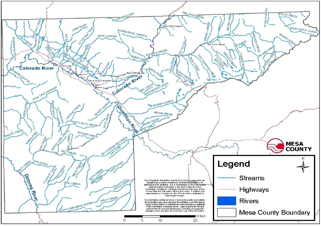
(Nelson, 2009)
(Res. 61-20, 10-7-20; Res. 32-15, 7-1-15; Res. 05-10, 1-6-10)
42.08.260 Hazardous materials.
(a) Hazard Description. A hazardous material is any item or agent (biological, chemical, physical, radiological) that has the potential to cause harm to humans, animals, or the environment, either by itself or through interaction with other factors. The release of hazardous materials can happen either by accident or as a result of criminal activity and can threaten people and natural resources in the immediate vicinity of the accident, including residences and businesses along transportation routes.
(b) Geographic Location. Mesa County is a center of commerce in western Colorado and hazardous materials are commonly transported through the County by truck and rail. Designated truck routes are State Highways 139, 141, 50 and U.S. Interstate 70. The Union Pacific Railroad operates two rail lines in Mesa County. Their main line is located primarily along the Colorado River through the County. The secondary line (southern leg) branches off the main line near the confluence of the Gunnison and Colorado Rivers and is located along the Gunnison River.
It is observed that the majority of the products transported through Mesa County belong to the hazard classes of 2 (Flammable and Combustible Gases), 3 (Flammable and Combustible Liquids), 8 (Corrosive Materials), and 9 (Miscellaneous Hazardous Materials). There are currently 193 Tier II reporting fixed site facilities in Mesa County. These facilities either produce, store, and/or use hazardous materials and are required by the Environmental Protection Agency to report these quantities under Tier II reporting requirements.
(c) Previous Occurrences. Two significant incidents have occurred in Mesa County as a result of illegal dumping of hazardous materials. The first incident involved illegal dumping in the Cactus Park area of Mesa County of three 150-pound cylinders of liquid chlorine with safety caps removed. This case resulted in a felony conviction of a 30-year-old male who received eight years in the Colorado State Corrections System. This case was the first successful prosecution of the “Clean Air Act” in the State of Colorado. (Reekie, 2009)
The second case occurred in 2001 and was the result of illegal discharging of ethylene glycol into the Colorado River. The facility was discharging through the conveyance of storm water system piping directly into the Colorado River. The illegal discharges resulted in a substantial “fish kill” to native aquatic life. This case resulted in a felony conviction of the corporation and individuals responsible. The environmental remediation was conducted by the Environmental Protection Agency. Remediation costs were approximately $1,500,000. The business was charged with felony charges resulting in significant fines and imprisonment. This case was the first successful prosecution of the “Clean Water Act” in the State of Colorado. (Reekie, 2009)
The Grand Junction Fire Department that serves as the Designated Emergency Response Authority for the entire planning area identified the following as significant incidents in Mesa County:
(1) 1990 – Motor Carrier 338 carrying 70,000 pounds of liquid oxygen caused one injury and $70,000 in damage.
(2) 1991 – Motor Carrier 331 carrying propane caused $100,000 in damage due to remediation of highway shoulder from diesel contamination.
(3) 1991 – Illegal dumping of three 150-pound cylinders of liquid chlorine with safety caps removed in Cactus Park area.
(4) 1992 – Two tractor trailer 40-foot cargo trailers (MC 331 carrying propane) collide causing two injuries and $200,000 in damage.
(5) 1992 – Motor Carrier 306 with 7,000 gallons of naphtha crashes into rock wall on Highway 141. Highway closed for 36 hours. $200,000 in damage.
(6) 1995 – Hazardous materials release at fixed facility. Nitric acid tank endothermic reaction at fixed facility. Resulted in $60,000 in damages.
(7) 2001 – Illegal discharge of ethylene glycol into the Colorado River.
(8) 2002 – Hazardous materials release from Amtrak derailment in Ruby Canyon with 123 passengers on board; $300,000 in property damage and $20,000 in environmental remediation.
(9) 2008 – Hazardous materials release with two tractor trailers with coal and hydrochloric acid with property damage of $250,000 and $80,000 in environmental remediation.
(10) 2011 – Tanker rolled 30 feet down an embankment on Highway 141 resulting in loss of two-thirds of its 7,000 gallon light crude oil cargo.
(11) 2013 – Approximately 26 pounds of chlorine leaked at a water utility as a result of a valve not being shut properly.
(12) 2014 – Approximately 100 pounds of ammonia leaked from a refrigeration unit at a business.
(d) Probability of Future Occurrence. Highly likely – near 100 percent chance of occurrence next year or it happens every year. Hazardous materials related incidents occur in Mesa County every year. Most often these incidents involve the transportation sector and are often fuel spills or cargo that is being transported.
(e) Magnitude/Severity. The magnitude/severity of a hazardous materials incident in Mesa County has been limited with impacts to the environment, property destroyed or severely damaged, and/or interruption of essential facilities and service for more than 72 hours.
Impacts in the past have been limited, but depending on the type and quantity of material released, an event could have serious consequences to the public. Humans and animals are affected through inhalation, ingestion, or direct contact with the skin. Air releases can prompt large-scale population evacuations and spills into water or onto the ground can adversely affect public water and sewer systems.
(Res. 61-20, 10-7-20; Res. 32-15, 7-1-15; Res. 05-10, 1-6-10)
42.08.270 Landslide, rockfall.
(a) Hazard Description. The Colorado Geological Survey department defines landslides as the downward and outward movement of slopes composed of natural rock, soils, artificial fills, or combination thereof. Landslides move by falling, sliding, and flowing along surfaces marked by difference in soil or rock characteristics. A landslide is the result of a decrease in resisting forces that hold the earth mass in place and/or an increase in the driving forces that facilitate its movement.
Landslides as defined above include two major types: (1) rotational slides which refer to all landslides having a concave upward, curved failure surface and involving a backward rotation of the original slide mass; and (2) translational slides in which the surface of rupture along which displacement occurs is essentially planar. Either type of landslides can involve various combinations of bedrock, broken bedrock, and unconsolidated superficial material, and the displaced material in either type of slide may be either greatly deformed or nearly intact.
Rate of movement of landslides varies from very slow to very rapid. They may be extremely small in extent or measurable in miles. Volumes of material involved may range from a few cubic feet to millions of cubic yards. Landslides result from some change in the physical condition of an unstable slope area (see section of guidelines on potentially unstable slopes). Such changes may be natural or man-induced.
A rockfall is the falling of a detached mass of rock from a cliff or down a steep slope. Weathering and decomposition of geological materials produce conditions favorable to rockfalls. Rockfalls occur most frequently in mountains or other steep areas during the early spring when there is an abundance of moisture and repeated freezing and thawing. (Survey, 2004)
(b) Geographic Location. The geographic location of landslides and rockfalls throughout Mesa County is isolated – which is less than 10 percent of the area.
The landslides and rockfalls that have occurred in Mesa County are most typically associated with canyons. The areas most affected by landslides-rockfalls include: Interstate 70 in DeBeque Canyon and along the Bookcliffs, Highway 65 in Plateau Canyon, Highway 141 in John Brown Canyon near Gateway, Colorado, and the area encompassing the Colorado National Monument.
The DeBeque Canyon Landslide is a major landslide complex in western Colorado that has historically impacted the east-west highway and railway corridor on the Colorado River as shown in Figures 9 and 10.
Figure 9: Mesa County Landslide Map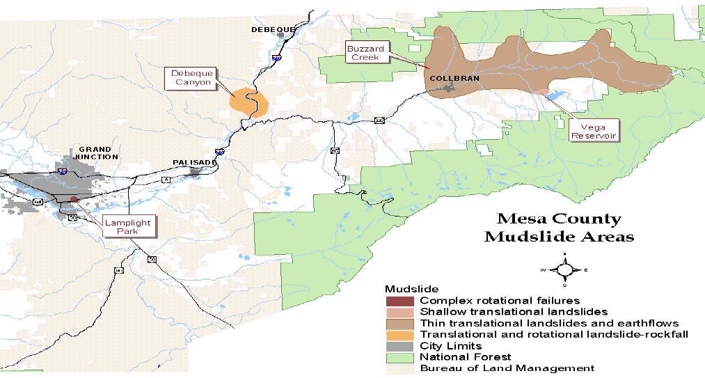
Source: Mesa County GIS
Figure 10: DeBeque Canyon Slide Area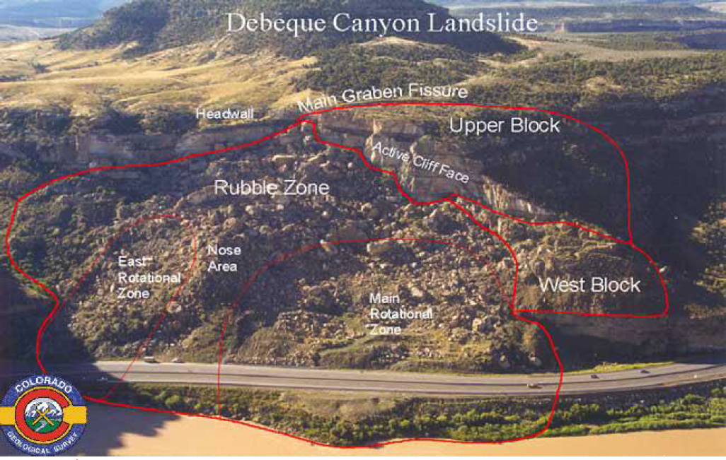
(Survey, 2004)
Figure 11: Photo of DeBeque Canyon Slide Area – Interstate 70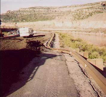
Figure 12: Photo of DeBeque Canyon Slide Area – Interstate 70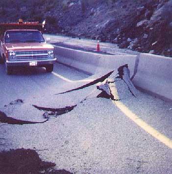
(Photos taken by Mesa County Emergency Management – 1998 Slide in DeBeque Canyon)
Figure 13: Rockfall West of Palisade Along Interstate 70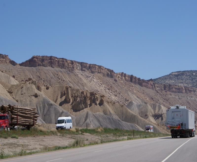
(Photos taken by Mesa County Emergency Management, July 8, 2009)
Figure 14: Rockfall Event in DeBeque Canyon at Beaver Tail Tunnel on Interstate 70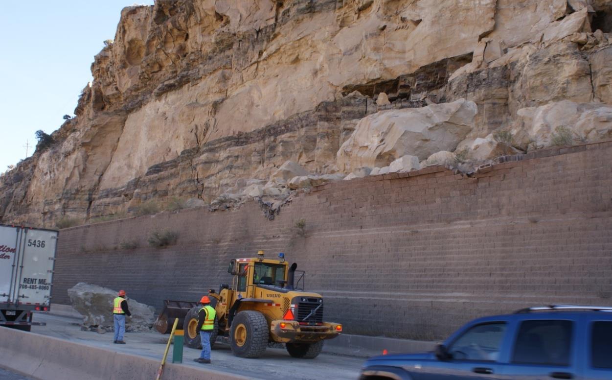
Figure 15: Rockfall Event in DeBeque Canyon at Beaver Tail Tunnel on Interstate 70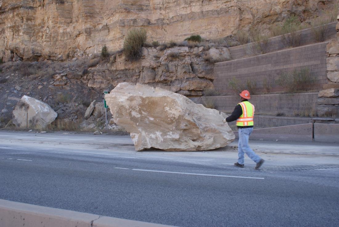
(Photos taken by Mesa County Emergency Management 10/26/09)
(c) Previous Occurrences. The DeBeque Canyon Landslide, which is considered a major landslide complex, has had three significant reactivations or ground movements during the past century. The precise date of the first major movement is unknown but occurred in the late 1890s or early 1900s. That slide movement was the largest and reportedly shifted the river channel and damaged railroad facilities on the north bank of the Colorado River.
The second noteworthy movement occurred in February 1958 when the roadway was widened for a modern two-lane highway. The widening resulted in further cutting and destabilizing of the landslide toe, with subsequent movements resulting in the heaving of the roadway 23 vertical feet. In April 1998, the third major movement occurred and caused Interstate 70, constructed in the mid-1980s, to heave 14 vertical feet. This highway also shifted five to six feet laterally towards the river during this event as shown in Figures 11 and 12. (Survey, 2004)
In 2004, rain and snow loosened several rocks resulting in several injuries to motorists traveling on Interstate 70. In 2006 a rockfall along Interstate 70 just outside of the Town of Palisade resulted in a 300-pound boulder hitting several cars traveling on Interstate 70, injuring several motorists who required medical treatment. Additional rockfall activity has occurred in the DeBeque Canyon resulting in isolated deaths and injuries.
In July of 2009 a significant rockfall occurred on the Bookcliffs approximately two miles west of the Town of Palisade; see Figure 13. What was unique about this rockfall was the amount of energy associated with it. This particular event registered a 2.6 on the Richter scale and was first thought to have been an earthquake. After hours of analysis it was determined that the event was actually a rockfall event, possibly triggered due to the moisture in the soil.
A rockfall event occurred in DeBeque Canyon near the Beaver Tail tunnel on Interstate 70. A significant amount of large boulders landed on the interstate closing all lanes of traffic for a period of time as seen in Figures 14 and 15. No injuries were reported.
The West Salt Creek Landslide occurred on May 25, 2014, near the town of Collbran in eastern Mesa County. The landslide mobilized 30,000,000 cubic meters of material and took the lives of three men. The landslide cut off West Salt Creek and the rotated slide block created a sag pond that detains the flow of West Salt Creek. This incident resulted in both local and State emergency declarations. Considerable work has been done to establish monitoring systems and understand the hazard of the remaining slide block and sag pond. Monitoring will be ongoing for a number of years. The West Salt Creek Landslide can be seen in Figures 16 and 17.
Figure 16: West Salt Creek Landslide Viewed from the East Flank of the Head Escarpment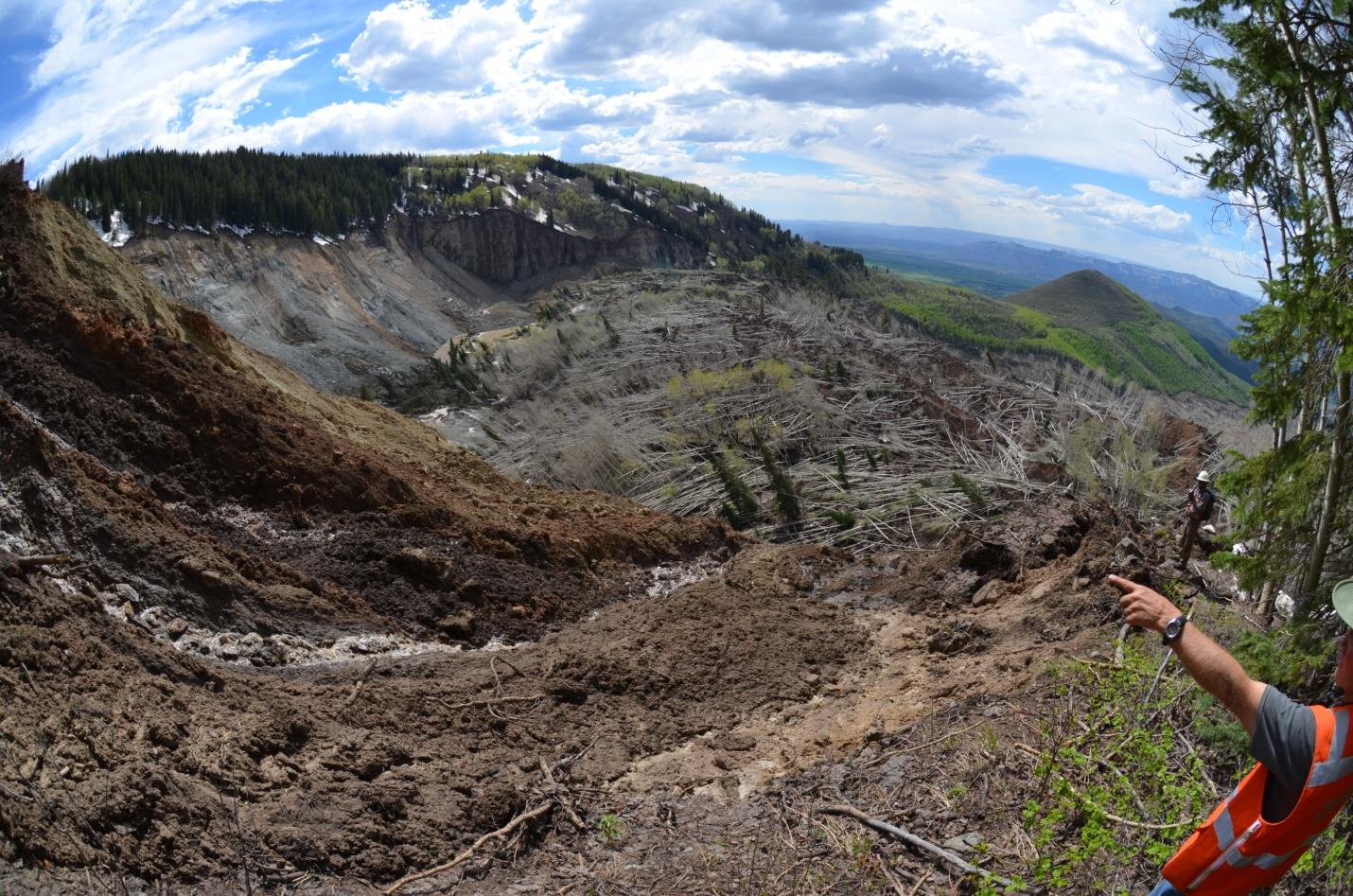
Figure 17: West Salt Creek Landslide Change in Topography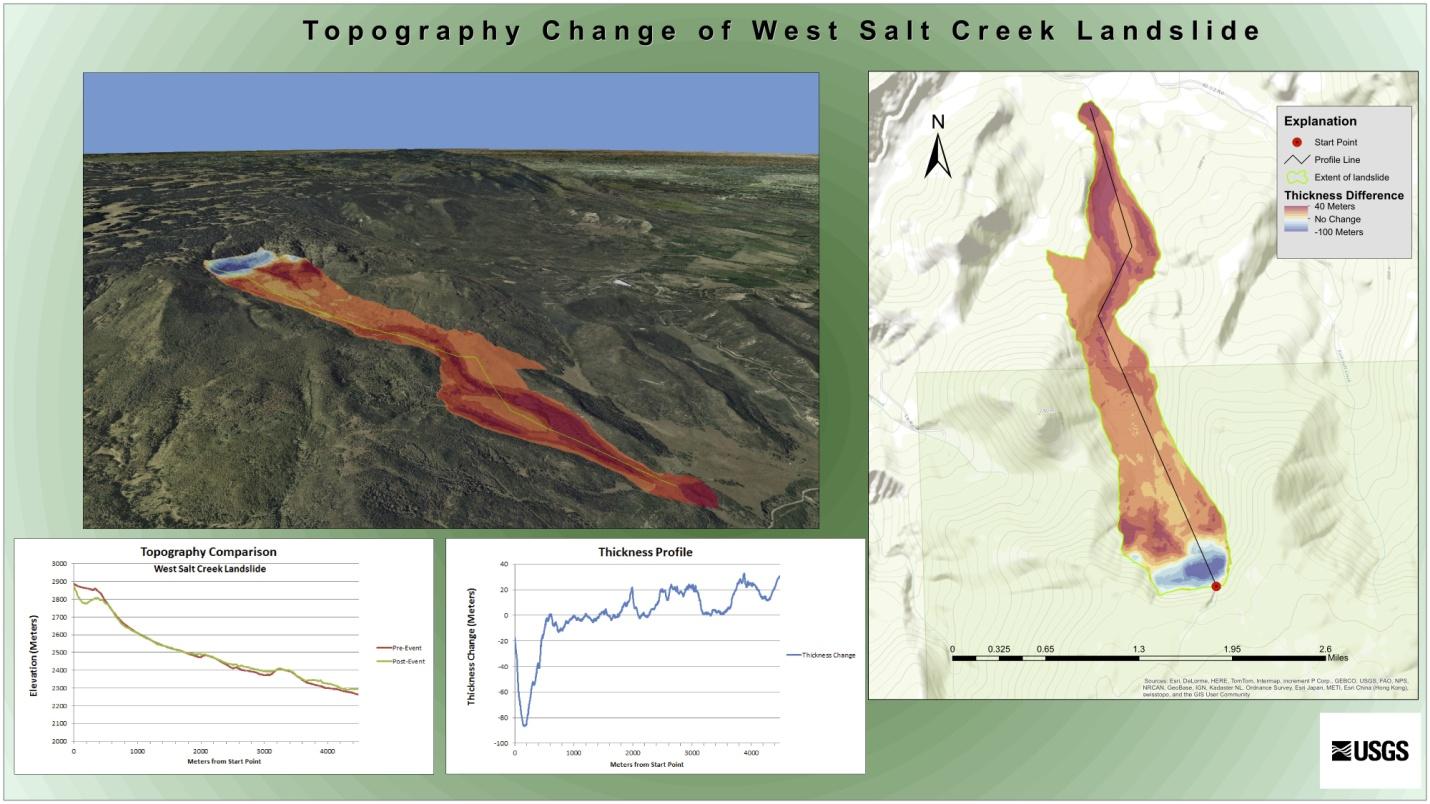
In July, 2019, a DeBeque Canyon land owner allowed water to flow into his dry rock quarry – in violation of his permit. The water seeped to canyon walls above Interstate 70 loosening rocks and endangering motorists on I-70. The Colorado Department of Transportation spent $1,300,000 to mitigate damage to canyon walls and to install rock fence.
(d) Probability of Future Occurrence. The probability of future occurrence is considered highly likely based on past events.
(e) Magnitude/Severity. The magnitude/severity of a landslide-rockfall event in Mesa County is critical. Past events have resulted in isolated deaths and/or multiple injuries as well as major or long-term property damage that threatens structural stability and/or interruption of essential facilities for 24 to 72 hours.
(Res. 61-20, 10-7-20; Res. 32-15, 7-1-15; Res. 05-10, 1-6-10)
42.08.280 Lightning.
(a) Hazard Description. Lightning is defined as “an abrupt, discontinuous natural electric discharge in the atmosphere.” The rising air in a thunderstorm cloud causes various types of frozen precipitation to form within the cloud. Included in these precipitation types are very small ice crystals and much larger pellets of snow and ice. The smaller ice crystals are carried upward toward the top of the clouds by the rising air while the heavier and denser pellets are either suspended by the rising air or start falling toward the ground. Collisions occur between the ice crystals and the pellets, and these collisions serve as the charging mechanism of the thunderstorm. The small ice crystals become positively charged while the pellets become negatively charged. As a result, the top of the cloud becomes positively charged and the middle to lower part of the storm becomes negatively charged. At the same time, the ground underneath the cloud becomes charged oppositely of the charges directly overhead.
When the charge difference between the ground and the cloud becomes too large, a conductive channel of air develops between the cloud and the ground, and a small amount of charge (step leader) starts moving toward the ground. When it nears the ground, an upward leader of opposite charge connects with the step leader. At that instant this connection is made, a powerful discharge occurs between the cloud and the ground. We see this discharge as a bright visible flash of lightning. (NWS, 2008)
Each year in the United States, more than 400 people are struck by lightning. On average, between 55 and 60 people are killed; hundreds of others suffer permanent neurological disabilities.
(b) Geographic Location. The geographic location of this hazard is considered large as it can happen anywhere in the County. However, lightning strikes are isolated in that the area that is affected by a lightning strike is less than 10 percent of the planning area.
(c) Previous Occurrences. Data from the National Lightning Network ranks Colorado second in the number of deaths (24) from 2002-2011 for deaths caused by lightning. While lightning is a regular occurrence in Mesa County, there are few documented cases where lightning has caused structural damage.
(1) September 13, 1996 – Lightning hit a tree and then traveled into an adjacent house causing some fire and electrical damage. Estimated damage was reported at $4,000.
(2) September 6, 1997 – Lightning struck a house on the north side of the Grand Mesa destroying some electrical items and blackening a wall on the side of the house.
(3) September 13, 1997 – Lightning struck a tree and power pole, setting the tree on fire and destroying a power transformer. Some electrical damage was also incurred at a nearby home.
(4) September 21, 1997 – Lightning strike of a two-story house, causing the house to catch on fire.
(5) September 9, 1998 – A man was injured when lightning struck a 12-foot-high pole on a trailer next to the man. The lightning also struck the man who was jolted off the trailer, landing 20 feet away. He suffered minor burns.
(6) August 20, 2000 – Lightning struck two horses, killing one and paralyzing the other. The two horses were found 50 feet apart from each other.
(7) July 7, 2013 – An intense late night thunderstorm produced locally heavy rainfall and a lot of lightning in the Grand Valley, including a lightning bolt that caused significant damage to a childcare facility.
(8) July 2, 2016 – A thunderstorm produced a lightning bolt which struck a girl riding an ATV near Glade Park. The girl was injured but survived.
Many of the lightning strikes that occur in Mesa County are the cause of wildland fires throughout the County and many strikes go unreported.
(d) Probability of Future Occurrence. The probability of lightning strikes in Mesa County is highly likely with a near 100 percent chance of occurrence next year or it happens every year.
(e) Magnitude/Severity. The magnitude/severity of lightning throughout Mesa County is limited with minor injuries and illnesses; minimal property damage that does not threaten structural stability; and/or interruption of essential facilities and services for less than 24 hours.
It is recognized that lightning can cause deaths, injuries, and property damage, including damage to buildings, communications systems, power lines, and electrical systems.
(Res. 61-20, 10-7-20; Res. 32-15, 7-1-15; Res. 05-10, 1-6-10)
42.08.290 Severe winter weather.
(a) Hazard Description. Severe winter weather can include heavy snow, ice, wind chill, blowing snow, freezing rain, sleet, and extremely cold temperatures. Any of these conditions can immobilize our community. These conditions can strand commuters, stop supplies and disrupt power and communication sources. The cost of snow removal, damage repair, and business losses can have a significant impact on the community.
Severe winter storms are usually accompanied by high winds, creating blizzard conditions causing snow to drift, making travel dangerous. Extreme cold temperatures are often associated with winter weather and prolonged exposure can be life-threatening. The months of December, January, and February are the most likely time of the year for severe winter weather.
Grand Junction receives about two feet of snow per year and it generally falls a few inches at a time and then melts off. The ground is usually not covered in snow and there is generally no need to shovel snow constantly. The winter months dip down into the teens and occasionally lower. Most years will see a maximum low temperature for the year of about zero to five degrees Fahrenheit. The average December-January high is 39 with an average low of 16 degrees Fahrenheit. The coldest months on average in Mesa County are January and February and Mesa County’s record minimum temperature was recorded as -23 degrees Fahrenheit in 1963. (NWS, 2008)
(b) Geographic Location. The geographic location of severe winter weather in Mesa County is small with approximately 25 to 50 percent of the County affected. Primarily severe winter weather is found in the higher elevations of the County and include: Grand Mesa, Colorado National Monument, and the Uncompahgre areas. The valley area of the County can see severe winter weather in snowfall, icy conditions, cold temperatures and wind.
(c) Previous Occurrences. The National Climatic Data Center Storm Events Database was used to determine the 287 recorded winter weather events that included some portion of Mesa County. These events ranged from heavy snowfall to blowing and drifting snow from significant wind gusts. (Hinson, National Climatic Data Center, 2009). There have been 54 events between 2010 to 2013.
On January 9, 2017, an abnormally mild Pacific storm system produced rainfall which fell into some western Colorado valleys where trapped air with temperatures below freezing resulted in the formation of freezing rain. Ice up to half of an inch thick quickly accumulated on roads and other surfaces at the beginning to the morning commute. There were hundreds of vehicle accidents and many roads were closed due to crashed vehicles blocking those roads. There were numerous injuries to those who slipped and fell. Emergency rooms in the Grand Valley exceeded their daily admittance records with over 200 people treated for broken bones and other blunt force injuries. Schools were closed throughout the Grand Valley and many businesses were negatively impacted by either not opening, opening late, or the lack of customers.
(d) Probability of Future Occurrence. The probability of future occurrence is likely with a 10 to 100 percent chance of occurrence in next year or has a recurrence interval of 10 years or less. However, it should be noted that Mesa County on average has much milder winter seasons than other parts of the State.
(e) Magnitude/Severity. The magnitude and severity of severe winter weather in Mesa County is limited – resulting in minor injuries and illnesses; minimal property damage that does not threaten structural stability; and/or interruption of essential facilities and services for less than 24 hours.
Severe winter weather in Mesa County can result in property damage, localized power outages and force the closure of streets, highways, schools and businesses. Severe winter weather can escalate, creating life-threatening situations when emergency response is limited due to the conditions or when individuals are caught in the backcountry unprepared. Snow removal costs can also greatly impact local budgets.
(Res. 61-20, 10-7-20; Res. 32-15, 7-1-15; Res. 05-10, 1-6-10)
42.08.300 Wildfire.
(a) Hazard Description. “Wildfire” is the term applied to any unwanted, unplanned, damaging fire burning in forest, shrub or grass and is one of the most powerful natural forces known to humans. While sometimes caused by lightning, nine out of 10 wildfires are human-caused from smoking, campfires, equipment use, and arson.
On public lands in Mesa County, 74 percent of the wildfires started are from lightning and 26 percent are human-caused. However, many of the more destructive and costly fires have been human-caused. Most of these human-caused fires are started near areas where people congregate. This can include towns, subdivisions, or campgrounds. Undoubtedly, human-caused fires on public lands have the potential to threaten human life as well as property. (Paul, 2009)
Due to fuel accumulation in the form of fallen leaves, branches, and excessive plant overgrowth in forest and wildland areas, increasing hot weather, changing weather patterns, and increased residential development in the wildland-urban interface areas, the potential for wildfires to occur has increased. The potential for major loss of property and structures has also significantly increased with the wildland-urban interface. The risk to firefighters can be high. Similar fuels/fire/terrain was responsible for 17 firefighter deaths in neighboring Garfield County. (Paul, 2009)
Based on information contained in the State of Colorado Natural Hazards Mitigation Plan, a century of aggressive fire suppression combined with cycles of drought and changing land management practices has left many of Colorado’s forests unnaturally dense and ready to burn. Furthermore, the threat of wildfire and potential losses is constantly increasing as human development and population increases and the wildland-urban interface expands.
Many other areas of Mesa County now have an increased wildfire threat in areas where fire was not a problem in the past. This is due to a combination of irrigation and the introduction of nonnative plants. Nonnative tamarisk and Russian olive have invaded drainage areas. Excess, undrained irrigation water has created thick, unbroken stands of vegetation throughout the Grand Valley. The stands of tamarisk and Russian olive burn readily and pose a threat to homes and other structures. The spring 2009 Preserve Fire on the Redlands is a good example of this kind of fire. (Paul, 2009)
(b) Geographic Location. The geographic extent of this hazard in Mesa County is medium – 25 to 50 percent of the planning area affected.
(c) Previous Occurrences. According to data collected from the various Fire Protection Districts, the Mesa County Wildland Fire Team, the Bureau of Land Management, and the Colorado State Forest Service, Mesa County has had several significant wildfire events that have either burned a large amount of acres, structures, or involved a multi-agency response. These significant fires include the following:
(1) April 3, 1956 – Human caused wildfire at the intersection of Mesa Street and U.S. Hwy 65 with three structures destroyed.
(2) April, 1978 – Human caused wildfire known as Mesa Creek Fire (Easter Fire) burned one home with several others damaged.
(3) July 1, 1989 – Lightning caused wildfire burned 1,233 acres with approximately 100 homes evacuated.
(4) July 31, 1995 – Lightning caused wildfire known as Triangle Fire burned 5,343 acres and forced evacuation of 50 people.
(5) July 4, 2000 – Lightning caused wildfire known as Cone Mountain Fire burned 4,960 acres. No homes were threatened but forced road closure of John Brown Canyon.
(6) June 9, 2002 – Lightning strike resulting in wildfire known as the Miracle Complex Fire that burned 3,951 acres.
(7) June 10, 2002 – Human caused fire known as the Dierich Creek Fire burned 3,951 acres and forced the evacuation of 57 homes.
(8) July 4, 2004 – Human caused fire known as the 22 1/2 Road Fire burned 110 acres and threatened 20 homes.
(9) July 29, 2005 – Human caused fire known as the Turkey Track Fire burned 348 acres, a camp trailer, and the fire protection district’s water tender. This fire also forced the evacuation of approximately 20 people.
(10) June 21, 2007 – Human caused wildfire with three homes destroyed.
(11) July 21, 2008 – Lightning caused fire known as the Housetop Fire burned 143 acres and threatened multiple gas wells in the area.
(12) August 2, 2008 – Human caused wildfire known as the 48 1/4 Road Fire with one injury and one residence partially burned.
(13) May 11, 2012 – Lightning caused fire known as the Brushy Mountain Fire burned approximately 170 acres. The fire started on private land and burned onto National Forest lands on the Uncompahgre Plateau.
(14) June 26, 2012 – Lightning caused fire known as the Pine Ridge Fire burned 13,920 acres on private and federal lands. Parts of the town of DeBeque were evacuated and the fire caused closure of I-70 and the rail line through DeBeque canyon.
(15) July 10, 2012 – Lightning caused fire known as the Bull Basin Fire grew rapidly being fueled by extremely dry vegetation, low relative humidity, high temperatures, and windy conditions. The fire was quickly contained to approximately 20 acres due to the availability of severity resources that were prepositioned in Mesa County.
(16) April 2, 2018 – Human caused urban interface fire known as the Rosevale Fire burned one home, 10 acres and forced 363 homes to be evacuated. This early season fire occurred prior to spring green-up.
(17) April 19, 2018 – Human caused urban interface fire known as the Skipper Island fire burned 220 acres, closed I-70 for several hours, damaged power lines impacting 2,100 power customers. A man who admitted accidentally starting the fire was sentenced to 80 hours of community service. This early season fire occurred prior to spring green-up.
(18) May 25, 2018 – Human caused fire in DeBeque Canyon started as a result of a vehicle fire on I-70 known as the MM46 fire burned 120 acres, closed I-70 for hours, required evacuation of Island Acres State Park.
(19) July 29, 2018 – Lightning caused fire, known as Bull Draw Fire, started in Montrose County and burned into Mesa County on federal and private land burned 36,549 acres. Fire was not contained until mid-October, 2018.
(20) July 4, 2019 – Human caused urban interface fire known as the Riverview Fire burned 10 acres dangerously close to homes under Red Flag conditions. The fire was started by a juvenile discharging illegal fireworks. The juvenile plead guilty to fourth-degree arson and sentenced to 50 hours of public service and restitution in the amount of $10,000.
(21) August 17, 2019 – Human caused urban interface fire known as the Peach Festival fire burned five acres adjacent to the Colorado River near orchards and vineyards. The fire was caused by the Peach Festival fireworks display. One firefighter was transported to the hospital due to heat related injuries.
(d) Probability of Future Occurrence. Highly likely – Near 100 percent chance of occurrence next year or it happens every year.
(e) Magnitude/Severity. Critical – Isolated deaths and/or multiple injuries and illnesses; major or long-term property damage that threatens structural stability; and/or interruption of essential facilities and services for 24 to 72 hours.
Based on data received from the Bureau of Land Management and Mesa County GIS Department, the following risk assessment has been mapped out for the planning area. Figure 18 illustrates the areas where risk is significant if a wildfire were to occur.
Figure 18: Mesa County Wildfire Risk Assessment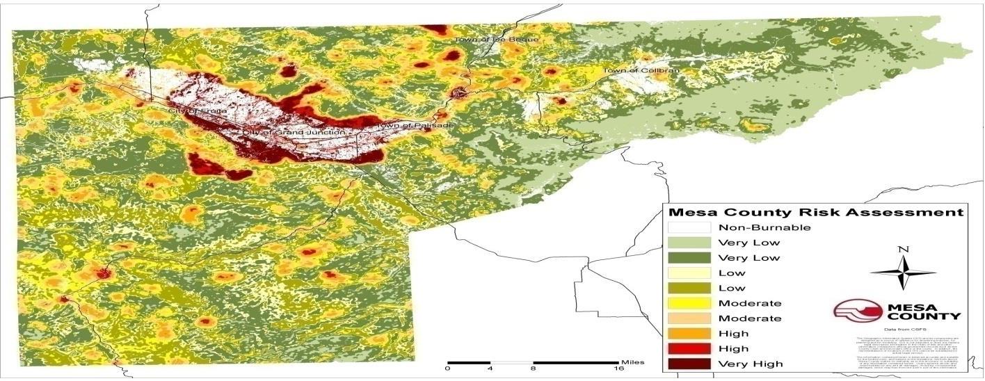
(Source: Bureau of Land Management)
(Res. 61-20, 10-7-20; Res. 32-15, 7-1-15; Res. 05-10, 1-6-10)
42.08.310 Windstorms/tornadoes.
(a) Hazard Description. High winds occur year round in Mesa County. In the spring and summer, high winds often accompany severe thunderstorms. These winds are typically straight-line winds, which are generally any thunderstorm wind that is not associated with rotation. It is these winds, which can exceed 80 miles per hour (mph), that represent the most common type of severe weather and are responsible for most wind damage related to thunderstorms.
(b) Geographic Location. The geographic extent of this hazard in Mesa County is large – more than 50 percent of the planning area affected.
(c) Previous Occurrences. Historical data from SHELDUS, NCDC Storm Data, and the National Weather Service, Grand Junction Office, reported 48 recorded wind events in Mesa County between 1974 and 2008. These wind events also include tornado events that have occurred in Mesa County. Between 2009 and 2013 there were nine recorded wind events. Nineteen events were recorded between 2015 and 2019, including a tornado on the Grand Mesa.
On July 9, 2015, a thunderstorm with rotation produced a tornado which tracked across a forest of mature aspen trees on the Grand Mesa. Many aspen trees up to a foot and a half in diameter were either uprooted or snapped off as high as 15 feet above the ground. The tornado initially produced damage to trees at the 8,400-foot level and traveled uphill to about the 8,500-foot level.
(d) Probability of Future Occurrence. Likely – 10 to 100 percent chance of occurrence in the next year or has a recurrence interval of 10 years or less.
There were 48 recorded wind events in the past 34 years in Mesa County which equals 1.4 wind events every year on average, or a 100 percent chance of occurrence in any given year.
(e) Magnitude/Severity. Limited – Minor injuries and illnesses; minimal property damage that does not threaten structural stability; interruption of essential facilities and services for less than 24 hours.
Windstorms in Mesa County are rarely life-threatening, but do threaten public safety, disrupt daily activities, cause damage to buildings and structures, increase the potential for other hazards (e.g., wildfire), and have adverse economic impacts from business closures and power loss. Although windstorms are likely to occur in the future, data indicates the past losses have not been significant, and the overall magnitude of this hazard is limited.
(Res. 61-20, 10-7-20; Res. 32-15, 7-1-15; Res. 05-10, 1-6-10)
42.08.320 Hazard profile summary.
This section summarizes the results of the hazard profiles and assigns a level of overall planning significance to each hazard of low, moderate, or high as indicated in Table 7. Significance was determined based on the hazard profile, focusing on key criteria such as geographic location, occurrences, magnitude and severity. This assessment was used by the HMPC to prioritize the hazards that present the greatest risk to the planning area. The hazards that occur infrequently or have little or no impact to the planning area were determined to be of low significance. Those determined to be of high significance were identified as priority hazards that require additional evaluation in the vulnerability assessment.
The priorities for this 2020 plan revision have not changed from the previous plan. The hazards that have been determined to be of high significance remain wildfire, flood, and landslide/rockfall. These hazards continue to be the focus in the vulnerability assessment and the focus of mitigation project proposals.
|
Hazard Type |
Geographic Location |
Occurrences |
Magnitude/Severity |
Total Score |
Hazard Level |
|---|---|---|---|---|---|
|
Avalanche |
2 |
4 |
6 |
32 |
M |
|
Drought |
8 |
4 |
4 |
48 |
M |
|
Earthquake |
6 |
4 |
4 |
40 |
M |
|
Expansive Soils |
2 |
4 |
2 |
16 |
L |
|
Extreme Heat |
8 |
4 |
2 |
40 |
M |
|
Wildfire |
6 |
8 |
4 |
80 |
H |
|
Flood |
6 |
8 |
6 |
96 |
H |
|
Hailstorm |
4 |
4 |
2 |
24 |
L |
|
Land Subsidence |
2 |
4 |
4 |
24 |
L |
|
Landslide/Rockfall |
4 |
8 |
6 |
80 |
H |
|
Lightning |
2 |
8 |
4 |
48 |
M |
|
Tornado |
2 |
4 |
2 |
16 |
L |
|
Windstorm |
4 |
6 |
4 |
48 |
M |
|
Winter Storm |
6 |
6 |
2 |
48 |
M |
|
Dam Failure |
4 |
4 |
6 |
40 |
M |
|
Hazardous Materials |
2 |
8 |
4 |
48 |
M |
(Res. 61-20, 10-7-20; Res. 32-15, 7-1-15; Res. 05-10, 1-6-10)
42.08.330 Vulnerability assessment.
Requirement Section 201.6(c)(2)(ii)(A): The plan should describe vulnerability in terms of the types and numbers of existing and future buildings, infrastructure, and critical facilities located in the identified hazard area.
Requirement Section 201.6(c)(2)(ii)(B): [The plan should describe vulnerability in terms of an] estimate of the potential dollar losses to vulnerable structures identified in paragraph (c)(2)(i)(A) of this section and a description of the methodology used to prepare the estimate.
Requirement Section 201.6(c)(2)(ii)(C): [The plan should describe vulnerability in terms of] providing a general description of land uses and development trends within the community so that mitigation options can be considered in future land use decisions.
The vulnerability assessment further defines and quantifies populations, buildings, critical facilities and infrastructure, and other community assets at risk to natural hazards. The vulnerability assessment for this plan followed the methodology described in the FEMA publication Understanding Your Risks – Identifying Hazards and Estimating Losses (2002).
The vulnerability assessment is based on the best available data and the overall planning significance of the hazard. Data to support the vulnerability assessment was collected from the same sources identified for the hazard identification and hazard profile sections.
The vulnerability assessment includes three sections:
(a) Community Asset Inventory. This section is an inventory of assets exposed to hazards in Mesa County, including the total exposure of people and property; critical facilities and infrastructure; natural, cultural, and historic resources; and economic assets.
(b) Vulnerability by Hazard. This section describes the County’s overall vulnerability to each hazard; identifies existing and future structures, critical facilities, and infrastructure in identified hazard areas; and estimates potential losses to vulnerable structures, where data is available. Only hazards of moderate or high significance, or that have identified hazard areas, are addressed in the vulnerability assessment.
(c) Development and Land Use Trends. The final section analyzes trends in population growth, housing demand, and land use pattern.
In addition, a capability assessment was conducted for each jurisdiction as part of the risk assessment process. A capability assessment identifies the existing programs, policies, and plans that mitigate or could be used to mitigate risk to disasters. From a Countywide perspective the following capabilities are identified in Table 8. Jurisdiction specific information regarding capabilities is found in the Jurisdictional Annex of this plan (Article VII of this chapter).
|
Local Mitigation Capabilities Tracker for Local and State Plan Updates |
||||
|---|---|---|---|---|
|
|
||||
|
Planning and Regulatory |
Yes/No |
|
Administrative and Technical |
Yes/No |
|
Building Codes |
Yes |
|
Emergency Manager |
Yes |
|
Building Codes Year |
Yes |
|
Floodplain Administrator |
Yes |
|
BCEGS Rating |
Yes |
|
Community Planning: |
|
|
Capital Improvements Program (CIP) or Plan |
Yes |
|
– Planner/Engineer (Land Devel) |
Yes |
|
Community Rating System (CRS) |
Yes |
|
– Planner/Engineer/Scientist (Natural Hazards) |
Yes |
|
Community Wildfire Protection Plan (CWPP) |
Yes |
|
– Engineer/Professional (Construction) |
Yes |
|
Comprehensive, Master, or General Plan |
Yes |
|
– Resiliency Planner |
No |
|
Economic Development Plan |
Yes |
|
– Transportation Planner |
Yes |
|
Elevation Certificates |
Yes |
|
Building Official |
Yes |
|
Erosion/Sediment Control Program |
Yes |
|
GIS Specialist and Capability |
Yes |
|
Floodplain Management Plan or Ordinance |
Yes |
|
Grant Manager, Writer, or Specialist |
Yes |
|
Flood Insurance Study |
Yes |
|
Warning Systems/Services: |
|
|
Growth Management Ordinance |
Yes |
|
– General |
Yes |
|
Non-Flood Hazard-Specific Ordinance or Plan (e.g., Steep Slope, Wildfire, Snow Load) |
No |
|
– Flood |
No |
|
NFIP |
Yes |
|
– Wildfire |
No |
|
Site Plan Review Requirements |
Yes |
|
– Tornado |
No |
|
Stormwater Program, Plan, or Ordinance |
Yes |
|
– Geological Hazards (West Salt Creek Landslide) |
Yes |
|
Zoning Ordinance |
Yes |
|
Other |
|
|
Financial |
Yes/No |
|
Education and Outreach |
Yes/No |
|
Has community used any of the following to fund mitigation activities: |
|
|
Local Citizen Groups That Communicate Hazard Risks |
Yes |
|
– Levy for Specific Purposes with Voter Approval |
No |
|
Firewise |
No |
|
– Utilities Fees |
No |
|
StormReady |
Yes |
|
– System Development/Impact Development Fee |
No |
|
Other |
|
|
– General Obligation Bonds to Incur Debt |
No |
|
|
|
|
– Special Tax Bonds to Incur Debt |
No |
|
|
|
|
– Withheld Spending in Hazard-Prone Areas |
No |
|
|
|
|
– Stormwater Service Fees |
No |
|
|
|
|
– Capital Improvement Project Funding |
Yes |
|
|
|
|
– Community Development Block Grants |
No |
|
|
|
|
– Other (BLM Community Assistance Grant) |
Yes |
|
|
|
(Res. 61-20, 10-7-20; Res. 32-15, 7-1-15; Res. 05-10, 1-6-10)
42.08.340 Community asset inventory.
The following sections assess the population, structures, critical facilities and infrastructure, and other important assets in Mesa County at risk to natural hazards.
(Res. 61-20, 10-7-20; Res. 32-15, 7-1-15; Res. 05-10, 1-6-10)
42.08.350 Critical facilities and infrastructure.
A critical facility may be defined as one that is essential in providing utility or direction either during the response to an emergency or during the recovery operation. Table 9 displays the inventory of critical facilities in Mesa County. The information is based on available data from the Northwest All Hazard Emergency Management Region.
|
Facility Type |
Unincorporated Mesa County |
Grand Junction |
Collbran |
Palisade |
Fruita |
DeBeque |
|---|---|---|---|---|---|---|
|
Ambulance |
7 |
10 |
3 |
2 |
3 |
2 |
|
Bridge |
104 |
27 |
3 |
– |
6 |
1 |
|
Dam |
47 |
1 |
– |
– |
– |
– |
|
EOC |
1 |
– |
– |
– |
– |
– |
|
Communication Towers |
103 |
52 |
1 |
– |
2 |
– |
|
Fire Station |
7 |
5 |
1 |
1 |
1 |
1 |
|
Govt. Building |
3 |
14 |
1 |
1 |
1 |
1 |
|
Helicopter Staging |
– |
1 |
– |
– |
– |
– |
|
911 Communications Center |
– |
1 |
– |
– |
– |
– |
|
Medical Facility |
– |
3 |
– |
– |
1 |
– |
|
Schools |
|
|
|
|
|
|
|
District 51 |
15 |
19 |
1 |
2 |
5 |
1 |
|
Private |
2 |
5 |
|
|
|
|
|
Water – Wastewater |
2 |
1 |
1 |
1 |
1 |
1 |
|
College – University |
– |
2 |
– |
– |
– |
– |
|
Airport |
1 |
1 |
– |
– |
– |
– |
Note: Communication towers include cell towers, radio sites and TV translators. Other facilities in Mesa County, such as locations that hold concerts, sporting events, and other events that attract large numbers of people, may also be at higher risk due to concentrations of people.
(Res. 61-20, 10-7-20; Res. 32-15, 7-1-15; Res. 05-10, 1-6-10)
42.08.360 Natural, historic, and cultural assets.
Assessing the vulnerability of Mesa County to disaster also involves inventorying the natural, historic, and cultural assets of the area. This step is important for the following reasons:
(a) The community may decide that these types of resources warrant a greater degree of protection due to their unique and irreplaceable nature and contribution to the overall economy.
(b) If these resources are impacted by a disaster, knowing so ahead of time allows for more prudent care in the immediate aftermath, when the potential for additional impacts is higher.
(c) The rules for reconstruction, restoration, rehabilitation, and/or replacement are often different for these types of designated resources.
(d) Natural resources can have beneficial functions that reduce the impacts of natural hazards, such as wetlands and riparian habitat, which help absorb and attenuate floodwaters.
(Res. 61-20, 10-7-20; Res. 32-15, 7-1-15; Res. 05-10, 1-6-10)
42.08.370 Natural resources.
Natural resources are important to include in benefit-cost analyses for future projects and may be used to leverage additional funding for projects that also contribute to community goals for protecting sensitive natural resources. Awareness of natural assets can lead to opportunities for meeting multiple objectives. For instance, protecting wetlands areas protects sensitive habitat as well as attenuates and stores floodwaters. A number of natural resources exist in Mesa County, including wetlands, endangered species, and imperiled plant communities.
(Res. 61-20, 10-7-20; Res. 32-15, 7-1-15; Res. 05-10, 1-6-10)
42.08.380 Wetlands.
Wetlands are a valuable natural resource for communities, due to their benefits to water quality, wildlife protection, recreation, and education, and play an important role in hazard mitigation. Wetlands reduce flood peaks and slowly release floodwaters to downstream areas. When surface runoff is dampened, the erosive powers of the water are greatly diminished. Furthermore, the reduction in the velocity of inflowing water as it passes through a wetland helps remove sediment being transported by the water. They also provide drought relief in water-scarce areas where the relationship between water storage and stream flow regulation is vital. Figure 19 shows the wetlands that have been identified throughout Mesa County.
Figure 19: Mesa County Wetlands Areas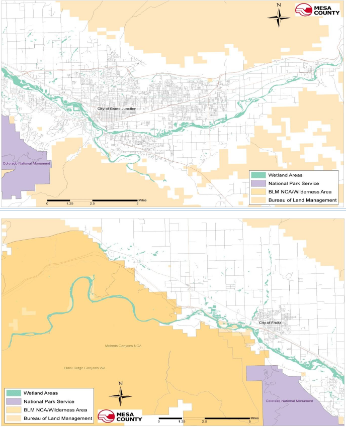
Source: Mesa County GIS
(Res. 61-20, 10-7-20; Res. 32-15, 7-1-15; Res. 05-10, 1-6-10)
42.08.390 Endangered species.
An endangered species is any species of fish, plant life, or wildlife that is in danger of extinction throughout all or most of its range. A threatened species is a species that is likely to become an endangered species within the foreseeable future throughout all or a significant portion of its range. Both endangered and threatened species are protected by law and any future hazard mitigation projects are subject to these laws. Candidate species are plants and animals that have been proposed as endangered or threatened but are not currently listed. Figure 20 is a map showing habitats for threatened and endangered species in Mesa County. (Nelson, 2009)
Figure 20: Mesa County Habitats for Threatened and Endangered Species
The Colorado Division of Parks and Wildlife provides the following information on their website regarding wildlife species found in Mesa County that have been given special designations, see Table 10.
|
Group |
Common Name |
Scientific Name |
Occurrence |
Abundance |
Status |
|---|---|---|---|---|---|
|
Amphibians |
Boreal Toad |
Bufo boreas |
Known to occur |
Unknown |
State Endangered |
|
Amphibians |
Northern Leopard Frog |
Rana pipiens |
Known to occur |
Common |
State Species of Concern, Federal Review |
|
Birds |
American Peregrine Falcon |
Falco peregrinus anatum |
Known to occur |
Rare |
State Species of Concern |
|
Birds |
Bald Eagle |
Haliaeetus leucocephalus |
Known to occur |
Casual/Accidental |
State Species of Concern |
|
Birds |
Ferruginous Hawk |
Buteo regalis |
Known to occur |
Very Rare |
State Species of Concern |
|
Birds |
Greater Sage Grouse |
Centrocercus urophasianus |
Known to occur |
Unknown |
State Species of Concern |
|
Birds |
Greater Sandhill Crane |
Grus canadensis tabida |
Known to occur |
Very Rare |
State Species of Concern |
|
Birds |
Gunnison Sage Grouse |
Centrocercus minumus |
Known to occur |
Rare |
State Species of Concern, Federal Threatened |
|
Birds |
Least Tern |
Sterna antillarum |
Known to occur |
Unknown |
Federal Endangered, State Endangered |
|
Birds |
Long-billed Curlew |
Numenius americanus |
Known to occur |
Casual/Accidental |
State Species of Concern |
|
Birds |
Mountain Plover |
Charadrius montanus |
Known to occur |
Unknown |
State Species of Concern |
|
Birds |
Plains Sharp-tailed Grouse |
Tympanuchus phassianellusjamesii |
Known to occur |
Unknown |
State Endangered |
|
Birds |
Southwestern Willow Flycatcher |
Empidonax traillii extiums |
Known to occur |
Rare |
Federal Endangered, State Endangered |
|
Birds |
Western Snowy Plover |
Charadrius alexandrinus nivosus |
Known to occur |
Unknown |
State Species of Concern |
|
Birds |
Whooping Crane |
Grus americana |
Known to occur |
Unknown |
Federal Endangered, State Endangered |
|
Fish |
Bonytail |
Gila elegans |
County Fish Data Not Kept by NDIS |
Federal Endangered, State Endangered |
|
|
Fish |
Razorback Sucker |
Xyrauchen texanus |
County Fish Data Not Kept by NDIS |
Federal Endangered, State Endangered |
|
|
Fish |
Humpback Chub |
Gila cypha |
County Fish Data Not Kept by NDIS |
Federal Endangered, State Endangered |
|
|
Fish |
Colorado Pikeminnow |
Ptychocheilus lucius |
County Fish Data Not Kept by NDIS |
Federal Endangered, State Endangered |
|
|
Fish |
Colorado Roundtail Chub |
Gila robusta |
County Fish Data Not Kept by NDIS |
State Species of Concern |
|
|
Fish |
Colorado River Cutthroat Trout |
Oncorhynchus clarki pleuriticus |
County Fish Data Not Kept by NDIS |
State Species of Concern |
|
|
Mammals |
Kit Fox |
Vulpes macrotis |
Known to occur |
Very Rare |
State Endangered |
|
Mammals |
Lynx |
Lynx canadensis |
Likely to occur |
Extirpated |
Federal Endangered, State Endangered |
|
Mammals |
Northern Pocket Gopher |
Thomomys talpoides |
Known to occur |
Common |
State Species of Concern |
|
Mammals |
River Otter |
Lontra canedensis |
Known to occur |
Rare |
State Threatened |
|
Mammals |
Townsend’s Big-eared Bat |
Plecotus townsendii |
Known to occur |
Uncommon |
State Species of Concern |
|
Mammals |
Wolverine |
Gulo gulo |
Likely to occur |
Extirpated |
State Endangered |
|
Reptiles |
Longnose Leopard Lizard |
Gambelia wislizenii |
Known to occur |
Uncommon |
State Species of Concern |
|
Reptiles |
Midget Faded Rattlesnake |
Crotalus viridis concolor |
Known to occur |
Uncommon |
State Species of Concern |
(CODPW, 2020)
(Res. 61-20, 10-7-20; Res. 32-15, 7-1-15; Res. 05-10, 1-6-10)
42.08.400 Imperiled natural plant communities.
The Colorado Natural Heritage Program (CNHP) tracks and ranks Colorado’s rare and imperiled species and habitats, and provides information and expertise on these topics to promote the conservation of Colorado’s valuable biological resources. The Statewide Potential Conservation Areas (PCA) map in Figure 21 shows CNHP’s best estimate of the primary area required to support the long-term survival of targeted species or natural communities. (About Us: Colorado Natural Heritage Program, 2009)
Figure 21: Potential Conservation Areas
(About Us: Colorado Natural Heritage Program, 2009)
(Res. 61-20, 10-7-20; Res. 32-15, 7-1-15; Res. 05-10, 1-6-10)
42.08.410 Ecologically sensitive areas.
Figure 22 shows the ecologically sensitive areas in Mesa County where threatened and endangered species and imperiled natural plant communities are most likely found.
Figure 22: Mesa County Ecologically Sensitive Areas
Source: Mesa County GIS
(Res. 61-20, 10-7-20; Res. 32-15, 7-1-15; Res. 05-10, 1-6-10)
42.08.420 Historical and cultural resources.
Several national and State historic inventories were reviewed to identify historic and cultural assets in Mesa County:
(a) The National Register of Historic Places is the nation’s official list of cultural resources. The National Register is part of a national program to coordinate and support public and private efforts to identify, evaluate, and protect historic and archaeological resources. Properties listed include districts, sites, buildings, structures, and objects that are significant in American history, architecture, archeology, engineering, and culture. The National Register is administered by the National Park Service, which is part of the U.S. Department of the Interior.
(b) The Colorado State Register of Historic Properties is a listing of the State’s significant cultural resources worthy of preservation. Properties listed in the Colorado State Register include individual buildings, structures, objects, districts, and historic and archaeological sites.
(c) Table 11 lists the properties and districts in Mesa County that are on the National Register of Historic Places.
|
Property Name |
City |
Location |
Date Listed |
|---|---|---|---|
|
Colorado National Monument Visitor Center Complex |
Mesa County |
Colorado National Monument |
07/15/2003 |
|
Colorado River Bridge |
Mesa County |
DeBeque Vicinity |
10/15/2002 |
|
Clifton Community Center and Church |
Mesa County |
Clifton |
06/30/1982 |
|
Coates Creek Schoolhouse |
Mesa County |
Glade Park |
02/03/1993 |
|
Convicts’ Bread Oven |
Mesa County |
Molina |
12/31/1974 |
|
Crissey, Herbert and Edith, House |
Palisade |
218 W. 1st St. |
05/18/2003 |
|
Cross Land and Fruit Company Orchards and Ranch |
Mesa County |
3079 F Road |
03/28/1980 |
|
DeBeque House |
DeBeque |
233 Denver Ave. |
07/28/1995 |
|
Denver and Rio Grande Western Railroad Depot |
Grand Junction |
119 Pitkin Ave. |
09/08/1992 |
|
Devils Kitchen Picnic Shelter |
Mesa County |
Colorado National Monument |
04/21/1994 |
|
Fruita Bridge |
Mesa County |
Cty. Rd. 17.50 over Colorado River |
02/04/1985 |
|
Fruita Museum |
Fruita |
432 E. Aspen |
10/10/1996 |
|
Grand Valley Diversion Dam |
Mesa County |
8 miles NE of Palisade |
10/08/1991 |
|
Handy Chapel |
Grand Junction |
202 White Ave. |
08/19/1994 |
|
Hotel St. Regis |
Grand Junction |
359 Colorado Ave. |
10/22/1992 |
|
IOOF Hall |
DeBeque |
4th St. and Curtis Ave. |
03/25/1993 |
|
Kettle-Jens House |
Mesa County |
498 32nd Road |
05/06/1983 |
|
Land’s End Observatory |
Mesa County |
Land’s End Road, 10 miles W of CO 65 |
02/28/1997 |
|
Loma Community Hall |
Mesa County |
1341 Co. Rd. 13, Loma |
11/22/1995 |
|
Margery Building |
Grand Junction |
519-527 Main Street |
02/24/1993 |
|
North 7th Street Historic Residential District |
Grand Junction |
7th St. between Hill and White Aves. |
01/05/1984 |
|
Phillips, Harry and Lilly House |
Fruita |
798 N. Mesa St. |
11/13/1997 |
|
Pipe Line School |
Mesa County |
101 16.5 Rd. Glade Park |
04/29/1999 |
|
Rim Rock Drive Historic District |
Grand Junction |
Colorado National Monument |
04/21/1994 |
|
Saddlehorn Caretaker’s House and Garage |
Grand Junction |
Colorado National Monument |
04/21/1994 |
|
Saddlehorn Comfort Station |
Grand Junction |
Colorado National Monument |
04/21/1994 |
|
Saddlehorn Utility Area Historic District |
Grand Junction |
Colorado National Monument |
04/21/1994 |
|
Serpents Trail |
Grand Junction |
Colorado National Monument |
04/21/1994 |
|
U.S. Post Office |
Grand Junction |
400 Rood Ave. |
01/31/1980 |
|
Cayton Ranger Station |
Mesa County |
White River National Forest, Silt Vicinity |
04/27/2005 |
|
Calamity Camp |
Mesa County |
Gateway Vicinity |
06/11/2011 |
|
TBM Avenger Aircraft N53503 |
Grand Junction |
780 Heritage Way |
11/13/2017 |
|
Stranges Grocery |
Grand Junction |
226 Pitkin Ave |
03/20/2013 |
|
Dept of Energy Grand Junction Office |
Grand Junction |
2591 Legacy Way |
07/26/2016 |
(National Register of Historic Places, 2020)
(d) Table 12 identifies the properties and districts in Mesa County that are on the Colorado Office of Archaeology and Historic Preservation site. Those properties listed in Table 11 were also listed on the State list.
|
Property Name |
City |
Location |
Date Listed |
|---|---|---|---|
|
Stockmens Bank |
Collbran |
111 Main St. |
03/08/1995 |
|
Circle Park |
Fruita |
Fruita Park Sq. |
05/14/1997 |
|
Fruita Elementary |
Fruita |
325 E. Aspen St. |
03/10/1993 |
|
Weckel House |
Mesa County |
1620 Hwy. 6 and 50 |
03/13/1996 |
|
Driggs Mansion |
Mesa County |
24505 State Highway 141 |
09/14/2005 |
|
Grand Junction Country Club |
Grand Junction |
2463 Broadway |
09/13/1995 |
|
Hurlburt-Knowles House |
Mesa County |
1151 13 Rd. Loma |
08/09/2000 |
|
Harlow Gravesite |
Mesa County |
869 Rapid Creek Rd. |
09/13/1995 |
|
Bloomfield Site |
Mesa County |
Whitewater Vicinity |
01/20/1983 |
|
Coffman House |
Mesa County |
4000 US Hwy. 50 |
12/12/2001 |
|
Land’s End Aboriginal Site |
Mesa County |
Land’s End Road |
03/11/1998 |
|
Raber Cow Camp |
Mesa County |
Land’s End Road |
03/10/1993 |
(National and State Registers)
(Res. 61-20, 10-7-20; Res. 32-15, 7-1-15; Res. 05-10, 1-6-10)
42.08.430 Economic assets.
Economic assets at risk may include major employers or primary economic sectors, such as agriculture, whose losses or inoperability would have severe impacts on the community and its ability to recover from disaster. After a disaster, economic vitality is the engine that drives recovery. Every community has a specific set of economic drivers, which are important to understand when planning ahead to reduce disaster impacts to the economy. When major employers are unable to return to normal operations, impacts ripple throughout the community. Table 13 lists the major employers in Mesa County based on the number of employees.
|
Employer |
Employees |
Industry |
|---|---|---|
|
Mesa County School District #51 |
2,785 |
Education |
|
St. Mary’s Hospital and Medical Center |
2,448 |
Healthcare |
|
Mesa County |
1,070 |
Government |
|
State of Colorado |
1,012 |
Government |
|
Community Hospital |
1,000 |
Healthcare |
|
VA Medical Center |
720 |
Healthcare |
|
City of Grand Junction |
652 |
Government |
|
Hilltop Community Resources |
600 |
Healthcare |
|
West Star Aviation |
441 |
Aviation |
|
Mind Springs Health |
433 |
Healthcare |
|
HopeWest |
350 |
Healthcare |
|
Strive |
304 |
Nonprofit |
|
Primary Care Partners |
304 |
Healthcare |
|
Family Health West |
282 |
Healthcare |
|
Navarro |
263 |
Technical/Professional Services |
|
United Companies |
203 |
Manufacturing |
|
StarTek, Inc. |
203 |
Telecommunications |
|
Capco, Inc. |
200 |
Manufacturing |
|
Union Pacific Railroad |
175 |
Transportation |
|
Coors Tek, Inc. |
150 |
Manufacturing |
|
The Daily Sentinel |
146 |
Media |
|
Reynolds Polymer Technology |
125 |
Manufacturing |
|
Mantey Heights Rehab and Care |
100 |
Healthcare |
(Data and Demographics: Grand Junction Economic Partnership, 2020)
(Res. 61-20, 10-7-20; Res. 32-15, 7-1-15; Senate Bill 11-265, 6-6-11; Res. 05-10, 1-6-10)
42.08.440 Vulnerability by hazard.
This section through GJMC 42.08.530 describe overall vulnerability and identify structures and estimate potential losses to buildings, infrastructure, and critical facilities located in identified hazard areas. This assessment was limited to the hazards that were considered moderate or high in planning significance, based on HMPC input and the hazard profiles. Hazards that ranked as “low significance” are not included in the vulnerability assessment. These include the following: expansive soils, hailstorm, land subsidence, and tornado.
Many of the identified hazards, particularly weather related hazards, affect the entire planning area, and specific hazard areas cannot be mapped geographically. For those hazards, which include drought, lightning, and winter weather, the vulnerability is mainly discussed in qualitative terms because data on potential losses to structures is not available.
(Res. 61-20, 10-7-20; Res. 32-15, 7-1-15; Res. 05-10, 1-6-10)
42.08.450 Avalanche.
Mesa County’s vulnerability to avalanches is moderate due to the historical events where loss of life has occurred. Thousands of people are exposed to avalanche risk in Mesa County every winter and spring due to the recreational use of backcountry areas. Motorists along highways are also at risk of injury or death if avalanches sweep across roadways.
(a) Existing Development. Mesa County does not have comprehensive information or mapping of avalanche hazard areas, therefore limiting available data on specific structures at risk or estimate of potential losses to structures.
(b) Future Development. Based on historic avalanche activity and lack of anticipated development in backcountry areas, there are no immediate plans to map avalanches in Mesa County.
(Res. 61-20, 10-7-20; Res. 32-15, 7-1-15; Res. 05-10, 1-6-10)
42.08.460 Dam failure.
Mesa County has a considerable amount of high hazard dams; if a failure of one of these high hazard dams occurred, it would result in loss of life. There is no specific evidence at the time this plan was written to indicate a failure of any dams in Mesa County.
Vulnerability to dam failure is greatest on the Grand Mesa where most of the dams are located and specifically the Town of Collbran which is downstream from many of the dams. A catastrophic dam failure would challenge local response capabilities and require evacuations to save lives. Impacts to life safety will depend on the timely warning of people in the area. Without immediate warning, loss of life could result as well as potentially catastrophic effects to roads, bridges, and homes.
(a) Existing Development. The Mesa County Department of Emergency Management retains copies of emergency action plans for all Class I and Class II dams in the County. The Mesa County Emergency Management Office has also worked with the Grand Junction Regional Communications Center to identify potential evacuation areas if a dam failure were to occur that is built into the reverse 911 system for notification purposes. Due to ongoing security concerns of the dam operators, Mesa County Emergency Management requests that inundation maps not be made part of this public planning process.
(b) Future Development. Efforts to map out additional evacuation areas that would be inundated in the event of a dam failure will continue with the Grand Junction Regional Communications Center. The County and towns should consider the dam failure hazard when permitting development downstream of the Class I and Class II dams.
(Res. 61-20, 10-7-20; Res. 32-15, 7-1-15; Res. 05-10, 1-6-10)
42.08.470 Drought.
Drought has been a significant issue in Mesa County. It is the one hazard that cannot be controlled yet it has devastating effects that can last for several years. Drought has several impacts to Mesa County including but not limited to: air quality, wildfires, reduction of tourism and recreation activities, and damage to the agriculture industry.
(a) Existing Development. The impacts from drought are nonstructural and generally affect the economy and environment the most. A drought event normally does not impact structures and it can be difficult to identify specific hazard areas. Many of the towns use public education efforts to encourage water conservation during the summer months.
(b) Future Development. Vulnerability to drought will increase as population growth increases, putting more demands on existing water supplies. Future water use planning should consider increase in population as well as potential impacts of climate change.
(Res. 61-20, 10-7-20; Res. 32-15, 7-1-15; Res. 05-10, 1-6-10)
42.08.480 Earthquake.
Past earthquake activity in Mesa County has been minimal and most earthquake activity has low magnitude and severity. Earthquake data in Mesa County is limited but some historical information is available through Colorado Mesa University.
(a) Existing Development. By using data from the HAZUS-MH software, information on potential economic and social losses due to an earthquake in Mesa County can be determined. This particular information produces “what if” scenarios (e.g., determines what would happen if an earthquake of a certain magnitude occurred on a particular fault). The earthquake magnitudes used for each fault were the “maximum credible earthquake” as determined by the U.S. Geological Survey.
There are 16 Quaternary aged faults identified by the USGS in Mesa County. There are innumerable older faults that have been identified and presumably older faults which remain hidden from view. The Quaternary aged faults are associated with the Uncompahgre Plateau. The Uncompahgre Plateau extends from Grand County, Utah, northwest of Grand Junction to near the Town of Ridgway, Colorado. The Uncompahgre has as much as 640 meters of uplift. The faults associated with the uplift are in two groups, bordering both the southwest flank and northeast flank of the uplift.
The northeast flank of the Uncompahgre Plateau, near Grand Junction, contains the Redlands Fault complex. This fault shows as much as 240 meters of displacement and can be seen most vividly in the Colorado National Monument. The Colorado Geological Survey has estimated that the largest earthquake possible on the Western Slope of Colorado is magnitude 6.5.
(b) Using the HAZUS-MH program, Emergency Management staff and a Colorado Mesa University faculty member designed and analyzed the following earthquake scenario on the Bridgeport/Cactus Park fault complex in southern Mesa County:
(1) Type: Deterministic, arbitrary.
(2) Attenuation Function: Western U.S. Shallow Crustal Event – Nonextensional.
(3) Magnitude: 5.5.
(4) Epicenter.
(i) Latitude 38.875, Longitude -108.438.
(ii) Depth: one kilometer.
(iii) Width: six kilometers.
(5) Fault Mechanism: Reverse Slip.
(6) Rupture.
(i) Subsurface Length: 5.88844 kilometers.
(ii) Surface Length: 4.02717 kilometers.
(iii) Orientation: 120 degrees.
(iv) Dip Angle: 75 kilometers.
While this is not the worst-case scenario for an earthquake event in Mesa County, it is believed to be a more plausible scenario (Wolny, Martsolf, 2009). Figure 23 provides an illustration of potential ground acceleration from this scenario.
Figure 23: HAZUS Earthquake Scenario
Figure 24 shows how far reaching this type of earthquake would be felt in Mesa County and Figure 25 identifies the area with displaced homes.
Figure 24: Bridgeport Earthquake Ground Motion
Figure 25: Bridgeport Earthquake Scenario, Displaced Homes
(c) In calculating building damage associated with this type of earthquake, the following HAZUS definitions were used:
(1) Slight damage. Small plaster or gypsum board cracks at corners of doors and window openings and wall-ceiling intersections, small cracks in masonry chimneys and masonry veneer.
(2) Moderate damage. Larger plaster or gypsum board cracks at corners of door and window openings; small diagonal cracks across shear wall panels exhibited by small cracks in stucco and gypsum wall panels; large cracks in brick chimneys; toppling of tall masonry chimneys.
(3) Extensive damage. Large diagonal cracks across shear wall panels or large cracks at plywood joints; permanent lateral movement of floors and roof; toppling of most brick chimneys; cracks in foundations; splitting of wood sill plates and/or slippage of structure over foundations; partial collapse of room-over garage or other soft-story configurations; small foundation cracks.
(4) Complete damage. Structure may have large permanent lateral displacement, may collapse, or be in imminent danger of collapse due to cripple wall failure or the failure of lateral load resisting system; some structures may slip and fall off the foundations; large foundation cracks.
Table 14 provides an estimated number of buildings damaged throughout Mesa County and the extent of damage to the various types of structures using this scenario.
|
Number of Buildings |
||||||
|---|---|---|---|---|---|---|
|
|
No Damage |
Slight Damage |
Moderate Damage |
Extensive Damage |
Complete Damage |
Total |
|
Wood |
28,677 |
2,296 |
384 |
25 |
0 |
31,382 |
|
Steel |
177 |
10 |
5 |
1 |
0 |
193 |
|
Concrete |
367 |
27 |
10 |
1 |
0 |
405 |
|
Precast |
192 |
16 |
13 |
3 |
0 |
224 |
|
Reinforced Masonry |
3,234 |
202 |
133 |
20 |
0 |
3,589 |
|
Manufactured Home |
2,086 |
295 |
156 |
16 |
0 |
2,553 |
|
Total |
34,733 |
2,846 |
701 |
66 |
0 |
38,346 |
Table 15 identifies the possible economic loss throughout Mesa County due to the number of damaged or destroyed buildings as a result of this type of earthquake.
|
Capital Stock Losses |
|||
|---|---|---|---|
|
Structural Damage Loss |
Nonstructural Damage Cost |
Contents Damage Cost |
Inventory Loss |
|
$11,819,000.00 |
$37,667,000.00 |
$15,472,000.00 |
$539,000.00 |
|
Income Losses |
|||
|---|---|---|---|
|
Relocation Loss |
Capital Related Loss |
Wage Losses |
Rental Income Loss |
|
$315,000.00 |
$2,977,000.00 |
$3,944,000.00 |
$4,520,000.00 |
|
Total Loss |
|---|
|
$65,497,000.00 |
(d) Much of the County’s recent development has building codes in place which reduce the risk of structural damage. However, historical buildings constructed of unreinforced masonry are most vulnerable to seismic ground shaking. Downtown Grand Junction is one of the areas most vulnerable to a seismic event due to older construction.
Similar to calculating damage to buildings, the analysis also allows us to estimate possible injuries sustained throughout Mesa County during a 5.5 magnitude earthquake. This data is shown in Table 16. HAZUS injury definitions are defined as the following:
(1) Severity 1. Injuries requiring basic medical aid without requiring hospitalization.
(2) Severity 2. Injuries requiring a greater degree of medical care and hospitalization, but not expected to progress to a life-threatening status.
(3) Severity 3. Injuries that pose an immediate life-threatening condition if not treated adequately and expeditiously. The majority of these injuries are the result of structural collapse and subsequent collapse or impairment of the occupants.
(4) Severity 4. Instantaneously killed or mortally injured.
|
Injury Severity Level |
|||||
|---|---|---|---|---|---|
|
Casualties at 2:00 a.m. event |
Severity 1 |
Severity 2 |
Severity 3 |
Severity 4 |
Total |
|
Commuting |
0 |
0 |
0 |
0 |
0 |
|
Commercial |
0 |
0 |
0 |
0 |
0 |
|
Educational |
0 |
0 |
0 |
0 |
0 |
|
Hotels |
0 |
0 |
0 |
0 |
0 |
|
Industrial |
0 |
0 |
0 |
0 |
0 |
|
Other – Residential |
7 |
1 |
0 |
0 |
8 |
|
Single-Family |
14 |
2 |
0 |
0 |
16 |
|
Total Casualties – 2:00 a.m. |
21 |
3 |
0 |
0 |
24 |
|
|
|||||
|
Casualties at 2:00 p.m. event |
Severity 1 |
Severity 2 |
Severity 3 |
Severity 4 |
Total |
|
Commuting |
0 |
0 |
0 |
0 |
0 |
|
Commercial |
13 |
2 |
0 |
0 |
15 |
|
Educational |
3 |
0 |
0 |
0 |
3 |
|
Hotels |
0 |
0 |
0 |
0 |
0 |
|
Industrial |
2 |
0 |
0 |
0 |
2 |
|
Other – Residential |
1 |
0 |
0 |
0 |
1 |
|
Single-Family |
3 |
0 |
0 |
0 |
3 |
|
Total Casualties – 2:00 p.m. |
22 |
2 |
0 |
0 |
24 |
|
|
|||||
|
Casualties at 5:00 p.m. event |
Severity 1 |
Severity 2 |
Severity 3 |
Severity 4 |
Total |
|
Commuting |
0 |
0 |
0 |
0 |
0 |
|
Commercial |
10 |
1 |
0 |
0 |
11 |
|
Educational |
0 |
0 |
0 |
0 |
0 |
|
Hotels |
0 |
0 |
0 |
0 |
0 |
|
Industrial |
1 |
0 |
0 |
0 |
1 |
|
Other – Residential |
3 |
1 |
0 |
0 |
4 |
|
Single-Family |
5 |
1 |
0 |
0 |
6 |
|
Total Casualties – 5:00 p.m. |
19 |
3 |
0 |
0 |
22 |
(e) Future Development. All jurisdictions within Mesa County have adopted building codes. Building codes substantially reduce the costs of damage to future structures from earthquakes. It is highly recommended that a specific study be done on the liquefaction hazards found within the Grand Valley. This is the single most important unknown in assessing the vulnerability of earthquakes in Mesa County.
(Res. 61-20, 10-7-20; Res. 32-15, 7-1-15; Senate Bill 11-265, 6-6-11; Res. 05-10, 1-6-10)
42.08.490 Floods.
Floods affect most of the communities in Mesa County and will continue to occur in the future. Floods can be critical in their magnitude and may cause deaths and damage to property and infrastructure.
(a) Existing Development. In 2005, Mesa County entered FEMA’s map modernization program to develop digital flood insurance rate maps (DFIRMS) in partnership with State and federal agencies. Mesa County has received a copy of the preliminary copies of the Digital Flood Insurance Rate Map (DFIRM) and Flood Insurance Study (FIS) report. Samples of DFIRMS are included in the community profiles for participating jurisdictions. A comprehensive collection of DFIRMS can be viewed on Mesa County’s website.
Analysis was done for each community in Mesa County to determine the proportion of value of buildings in the hazard areas that were identified by the HMPC. The GIS system was used by selecting parcels that have their center within the city or town limits, then by making a subselection of parcels that have their center within the areas subject to flooding. Structure value is based on the actual value of improvements. Specific information regarding flood losses is identified in the jurisdiction’s annex.
(b) Floodplain Management. The purpose of the Mesa County Floodplain Management program is to assist property owners with any improvements in the floodplain. The County’s goal is to help minimize property damage to residents of Mesa County during flood events. Mesa County wants to ensure that life, property including natural resource values, and/or new improvements are safe during flood events and that any structures or improvements in the floodplain will not cause additional drainage problems.
Regulations are in place to ensure that proposed improvements will not cause flooding problems upstream and/or downstream. Every manmade structure or improvement constructed within the floodplain area requires a floodplain development permit prior to beginning construction. A floodplain development permit authorizes a specific activity within the regulatory floodplain while minimizing the likelihood of property damage to buildings or improvements in the event of a flood. (County, Mesa County Public Works, Stormwater Management, 2009)
The National Flood Insurance Program (NFIP) is a federal program enabling property owners in participating communities to purchase insurance as a protection against flood losses. A jurisdiction’s eligibility to participate is premised on their adoption and enforcement of state and community floodplain management regulations intended to prevent unsafe development in the floodplain, thereby reducing future flood damages. Thus, participation in the NFIP is based on an agreement between communities and the federal government. If a community adopts and enforces a floodplain management ordinance to reduce future flood risk to new construction in floodplains, the federal government will make flood insurance available within the community as a financial protection against flood losses. Currently all of the communities in and including Mesa County participate in the National Flood Insurance Program.
(c) Future Development. Management of storm water is important to the communities in Mesa County. As mandated under the Clean Water Act, the U.S. Environmental Protection Agency has developed a National Pollutant Discharge Elimination System storm water permitting program. Phase II of this program addresses smaller urbanized areas, such as the Grand Valley. Currently the jurisdictions in Mesa County have identified areas where Phase II regulations are to be implemented, requiring storm water construction permits. (County, Mesa County Public Works, Stormwater Management, 2009)
(Res. 61-20, 10-7-20; Res. 32-15, 7-1-15; Res. 05-10, 1-6-10)
42.08.500 Landslide, mudflow/debris fall, rockfall.
In Mesa County, vulnerability to landslides primarily occurs along roadways, where the hazard could cause deaths or injuries. Road closures due to landslide events also affect the County economically.
(a) Existing Development. Under the Mesa County Land Development Code, Chapter 7, any proposed land use or development must identify hazard areas, i.e., floodplains, drainage areas, steep slope areas, geological fault areas, and other areas hazardous to life or property. Such proposals will require an evaluation to determine the degree to which the proposed activity will:
(1) Expose any person, including occupants or users of the proposed use or development, to any undue natural hazard.
(2) Create or increase the effects of natural hazard areas or other improvements, activities or lands.
(3) Impact the natural environment and be unduly destructive to the natural resources of an area.
Regulations also require proposed land uses to address soil, erosion, and surface geologic characteristics of the development site through proper design, engineering and construction. (County, Mesa County Planning Division, 2014)
Potential losses for the landslide areas in Mesa County were estimated using Mesa County GIS and assessor’s data and were examined in terms of values and critical facilities at risk. Detailed information pertaining to specific jurisdictions is found in that jurisdiction’s community profile.
(b) Future Development. The severity of landslide problems is directly related to the extent of human activity in hazard areas. Adverse effects can be mitigated by early recognition and avoiding incompatible land uses in these areas or by corrective engineering. The mountainous topography of the County presents considerable constraints to development, most commonly in the form of steep sloped areas. These areas are vulnerable to disturbance and can become unstable. Most of these areas are adjacent to roadway systems that are heavily used. Continued adherence to the Land Development Code is necessary.
(Res. 61-20, 10-7-20; Res. 32-15, 7-1-15; Res. 05-10, 1-6-10)
42.08.510 Lightning.
Lightning events are likely to occur throughout Mesa County and can result in deaths and destruction of property. Consequences of lightning may have destructive effects on power and information systems. Failure of these systems would have cascading effects throughout the County and could possibly disrupt other critical infrastructure such as water treatment facilities. Because lightning can occur anywhere in the County, data was not available to identify specific structures at risk or estimate potential losses.
(Res. 61-20, 10-7-20; Res. 32-15, 7-1-15; Res. 05-10, 1-6-10)
42.08.520 Severe winter weather.
(a) Existing Development. Winter storms can create significant public safety concerns and cause significant impacts to the local economy due to a disruption in the transportation of goods. On occasion, winter storms can overwhelm snow removal efforts, transportation, livestock management and business and commercial activities.
From previous events, Mesa County Emergency Management staff has identified the County’s elderly population as a significantly vulnerable population during winter storms especially when utility outages are associated with winter storms.
(b) Future Development. Population growth in the County will increase potential problems with traffic and snow removal, thereby putting pressure on local governments and emergency services. The Grand Valley does not typically experience significant winter storms; however, it has experienced utility outages associated with severe weather. Future efforts should be made to identify populations at risk and determine special needs.
(Res. 61-20, 10-7-20; Res. 32-15, 7-1-15; Res. 05-10, 1-6-10)
42.08.530 Wildfire.
(a) Existing Development. Past mitigation projects include a detailed, on the ground, wildfire hazard risk assessment for approximately 450 structures including private residences and outbuildings within the jurisdictions of Lower Valley Fire Protection District, Grand Junction Rural Fire Protection District and unincorporated Mesa County. Each structure was evaluated based on potential fuels, slope, aspect, fire disturbance regimes, access/egress, water supply, and structure ignitability. This data was compiled and incorporated into the County’s GIS system.
The GIS data shows structures that have been rated as to overall risk of wildfire, as well as those areas deemed most appropriate for wildland fire hazard mitigation efforts on both federal and non-federal lands within this area. This information is used to aid local fire departments and federal agencies in preparing fuels mitigation projects and preplanning fire prevention and protection strategies. This assessment also serves as the basis for public information and education efforts directed primarily by the Colorado State Forest Service and participating jurisdictions to encourage private property owners to participate in Firewise and other mitigation efforts to protect their property.
Mesa County Land Development Code specifically addresses development standards in hazard areas. All new development located on lands rated as medium or higher wildfire hazard shall be developed using defensible spacing standards. (County, Mesa County Planning Division, 2014)
(b) Future Development. Many areas in Mesa County now have an increased wildfire threat in areas where fire was not a problem in the past. This is due to a combination of irrigation and the introduction of nonnative plants. Nonnative tamarisk and Russian olive have invaded drainage areas. Excess undrained irrigation water has created thick unbroken stands of vegetation throughout the Grand Valley. These stands of tamarisk and Russian olive burn readily and pose a threat to homes and other structures. (Paul, 2009)
Additional wildfire assessments need to be conducted across Mesa County. Several areas are at significant risk to wildland fire and more education of property owners on how to create a defensible space around their homes and other structures is needed. Once the assessments have been completed, on the ground efforts to create defensible spacing or thinning of areas with substantial overgrowth need to be completed.
(Res. 61-20, 10-7-20; Res. 32-15, 7-1-15; Res. 05-10, 1-6-10)
42.08.535 Changes in development.
Between 2015 to 2019, there were 422 new subdivision plats recorded in Mesa County accounting for 3,558 subdivision lots. These new subdivision lots are distributed as detailed as follows:
(a) City of Grand Junction: 2,332.
(b) City of Fruita: 402.
(c) Town of Palisade: 54.
(d) Town of DeBeque: 0.
(e) Town of Collbran: 0.
(f) Unincorporated Mesa County: 770.
The number of building permits issued for the unincorporated area of Mesa County is reflected in the following table.
|
|
2015 |
2016 |
2017 |
2018 |
2019 |
|---|---|---|---|---|---|
|
Commercial Permits |
8 |
5 |
11 |
11 |
6 |
|
Residential Permits |
190 |
158 |
184 |
272 |
232 |
Individual community profiles contain additional information on new development within each respective community.
(Res. 61-20, 10-7-20; Res. 32-15, 7-1-15)
Article V. Mitigation Strategy
42.08.540 Mitigation strategy.
44 CFR Requirement Section 201.6(c)(3): The plan shall include a mitigation strategy that provides the jurisdiction’s blueprint for reducing the potential losses identified in the risk assessment, based on existing authorities, policies, programs and resources, and its ability to expand on and improve these existing tools.
This article presents the mitigation strategy developed by the Mesa County Hazard Mitigation Planning Committee (HMPC) based on the County’s risk assessment. The mitigation strategy was developed through a collaborative group process and consists of goals, objectives, and mitigation actions. The following definitions are based upon those found in FEMA publication 386-3, Developing a Mitigation Plan (2002):
(a) Goals. General guidelines that explain what you want to achieve. Goals are defined before considering how to accomplish them so that they are not dependent on the means of achievement. They are usually long-term, broad, policy-type statements.
(b) Objectives. Define strategies or implementation steps to attain the identified goals that are specific and measurable.
(c) Mitigation actions. Specific actions that help achieve goals and objectives.
(Res. 61-20, 10-7-20; Res. 32-15, 7-1-15; Res. 05-10, 1-6-10)
42.08.550 Goals and objectives.
The HMPC developed goals and objectives to provide direction for reducing hazard-related losses in Mesa County that were based on the results of the risk assessment. After reviewing the updated risk assessment, the HMPC determined that the previous plan’s goals and objectives are still valid.
(a) Goal 1. Reduce risk to the people, property, and environment of Mesa County from the impacts of natural hazards.
(1) Minimize the vulnerability of existing and new development to hazards.
(2) Increase education and awareness of hazards and risk reduction measures.
(3) Improve comprehensive wildfire planning, funding, and mitigation.
(4) Strengthen floodplain management programs.
(5) Enhance assessment of multi-hazard risk to critical facilities and infrastructure.
(b) Goal 2. Minimize economic losses.
(1) Strengthen disaster resistance and resiliency of businesses and employers.
(2) Promote and conduct continuity of operations and continuity of governance planning.
(3) Reduce financial exposure of County and municipal governments.
(c) Goal 3. Implement the mitigation actions identified in this plan.
(1) Engage collaborative partners, including community organizations, businesses, and others.
(2) Integrate mitigation activities into existing and new community plans and policies.
(3) Monitor, evaluate, and update the mitigation plan.
(Res. 61-20, 10-7-20; Res. 32-15, 7-1-15; Res. 05-10, 1-6-10)
42.08.560 Identification and analysis of mitigation actions.
44 CFR Requirement Section 201.6(c)(3)(ii): The mitigation strategy shall include a section that identifies and analyzes a comprehensive range of specific mitigation actions and projects being considered to reduce the effects of each hazard, with particular emphasis on new and existing buildings and infrastructure.
The HMPC representatives present at the third meeting identified, discussed, and prioritized potential mitigation actions. Representatives chose to focus on the top three hazards with an overall ranking of “High” to develop hazard specific mitigation actions. The three high hazards are: flooding, wildfire, and landslides-rockfalls. At the time the mitigation actions are complete, additional mitigation goals and actions will be developed for the remaining hazards. The additional hazards include: avalanche, dam failure, drought, hazardous materials, lightning, and severe winter weather. It is important to note that many of the final mitigation actions are multi-hazard actions designed to reduce potential losses from all types of hazard events.
The HMPC discussed the key issues for each priority hazard and discussed potential mitigation alternatives. The mitigation strategy worksheet (worksheet #4) was used to identify all possible mitigation actions for each of the three high hazards. Possible actions were discussed and eventually prioritized for the appropriate jurisdictions.
(Res. 61-20, 10-7-20; Res. 32-15, 7-1-15; Res. 05-10, 1-6-10)
42.08.570 Implementation of mitigation actions.
44 CFR Requirement Section 201.6(c)(3)(iii): The mitigation strategy shall include an action strategy describing how the actions identified in paragraph (c)(2)(ii) will be prioritized, implemented, and administered by the local jurisdiction. Prioritization shall include a special emphasis on the extent to which benefits are maximized according to a cost benefits review of the proposed projects and their associated costs.
Representatives prioritized the various mitigation actions based on the hazard that would be mitigated, cost estimate, and benefits to completing the mitigation actions preventing further loss, and possible funding opportunities for the actions. The process of identification and analysis of mitigation alternatives allowed the HMPC to come to consensus and to prioritize the recommended actions.
The Disaster Mitigation Act regulations state that cost-benefit review is the primary method for mitigation projects to be prioritized. Recognizing the federal regulatory requirement to prioritize by cost-benefit, and the need for any publicly funded project to be cost-effective, the HMPC decided to pursue implementation according to when and where damage occurs, available funding, political will, and jurisdictional priority.
The mitigation actions developed by the HMPC are listed in Table 17. The HMPC came to consensus on which departments and representatives are responsible for completing an implementation worksheet for each identified mitigation action. The worksheets document background information, cost estimates, benefits, and timeline for each action.
|
Mitigation Action Matrix |
||||
|---|---|---|---|---|
|
Jurisdiction |
Action |
Priority |
Goals Addressed |
Hazards Addressed |
|
Multi-jurisdictional |
Coordinate biannual reviews. |
High |
Goal 3 |
Multi-Hazard |
|
Multi-jurisdictional |
Continue public involvement in mitigation activities. |
High |
Goal 1 |
Multi-Hazard |
|
Multi-jurisdictional |
Coordinate and complete a continuity of operations/continuity of governance (COOP/COG) plan. |
High |
Goal 2 |
Multi-Hazard |
|
Multi-jurisdictional |
Identify and prioritize fuel reduction projects around critical facilities and infrastructure in wildfire hazard areas. Community education regarding the risk of wildfires. |
High |
Goal 1 |
Wildfire |
|
Town of Palisade: Fire Department |
Create a fire mitigation plan to protect vital raw water supplies and infrastructure. Conduct on the ground mitigation to reduce the potential for wildfire. |
High |
Goal 1, 2 |
Wildfire |
|
Multi-jurisdictional |
Incorporate information contained in Hazard Mitigation Plan into other planning mechanisms, when appropriate. |
High |
Goal 1, 2 |
Multi-Hazard |
|
Multi-jurisdictional |
Project includes two detention basins and 535 feet of box culvert improvements that will remove 269 structures from 100-year floodplain, including two churches and one elementary school, and decrease emergency response arterial inundation (Hwy. 50) by 0.43 feet (Orchard Mesa Detention and Conveyance Improvements). |
Medium |
Goal 1, 2 |
Flooding |
|
Mesa County |
Adobe Creek: Overbank flooding of properties is common during small events. Project will upgrade 13 structures and 2.5 miles of channel to achieve flow capacity for 10-year event level. |
Medium |
Goal 1, 2 |
Flooding |
|
Mesa County |
Douglas Wash: The existing drainage way and crossing structures are undersized and cannot convey the 100-year storm event. More than 55 properties are within the flooding area as a result. A study was completed and the recommended solution was to construct detention areas to control the flow within the channel. |
Medium |
Goal 1, 2 |
Flooding |
|
Multi-jurisdictional |
Mitigation project for the upper and lower portions of the Leach Creek drainage. These projects would provide mitigation to flood events for the area of Leach Creek above the confluence with Ranchmen’s Ditch. |
Medium |
Goal 1, 2 |
Flooding |
|
Mesa County, City of Grand Junction, City of Fruita, Town of Palisade |
NFIP Compliance: Jurisdictions will incorporate and reference DFIRM maps in regulations as new floodplains are mapped. Audits of regulations will ensure compliance with NFIP in all program areas. |
Medium |
Goal 1 |
Flooding |
|
Multi-jurisdictional |
Identify and map geologic hazard zones and incorporate into master planning. |
Medium |
Goal 1, 3 |
Landslide-Rockfall-Mudflow-Debris flow |
|
Multi-jurisdictional |
Real time rainfall data is lacking in Mesa County. An automated rainfall ALERT network would allow real time rainfall data access by local officials and National Weather Service forecasters for more timely flash flood warnings. |
Medium |
Goal 1, 3 |
Flooding |
|
Multi-jurisdictional |
A Basin Master Plan for Big Salt Wash will be completed. The plan will identify at risk properties, conveyance and detention mitigation alternatives and costs. |
Low |
Goal 1 |
Flooding |
|
Multi-Jurisdictional |
Community Resilience Planning: Develop the ability to function and sustain critical systems; adapt to changes in the physical, social, or economic environment; be self-reliant if external resources are limited or cut off. |
Medium |
Goal 1, 2, 3 |
Multi-Hazard |
|
Town of Palisade |
Fuel and Debris Reduction: Remove overgrowth, slash, and debris from steep river bank. |
High |
Goal 1 |
Wildfire, Flooding |
|
DeBeque FPD |
District Wildland Fire Assessment: Assess wildland-urban interface issues in district |
Medium |
Goal 1 |
Wildfire |
|
DeBeque FPD |
Reduce amount of fuels residents pile up for burning in and around the Town of DeBeque by establishing a wood chipping program |
Medium |
Goal 1 |
Wildfire |
|
Multi-Jurisdictional |
Review and update the 2012 Countywide Community Wildfire Protection Plan |
High |
Goal 1 |
Wildfire |
|
Multi-Jurisdictional |
StormReady Recertification: Complete actions necessary to maintain StormReady Certification. |
Medium |
Goal 1 |
Multi-Hazard |
|
Clifton FPD and Mesa County |
Lewis Wash wildfire mitigation project |
High |
Goal 1 |
Wildfire |
|
Town of Palisade |
Riverbend Park wildfire mitigation project |
High |
Goal 1 |
Wildfire |
|
City of Fruita and Lower Valley FPD |
Big Salt Wash wildfire mitigation project – Evening Breeze section |
High |
Goal 1 |
Wildfire |
|
City of Grand Junction and GJ Rural FPD |
Identify, prioritize, support, and conduct fuels mitigation in Wildland Urban Interface. |
High |
Goal 1 |
Wildfire |
|
City of Grand Junction |
Emergency Action Plans for Dam Safety |
High |
Goal 1, 2 |
Flooding |
|
City of Grand Junction |
Fire Mitigation for Grand Junction Watershed |
High |
Goal 1 |
Wildfire |
|
City of Grand Junction |
Carson Lake Dam Rehabilitation and Early Warning System |
High |
Goal 1, 2 |
Flooding |
Note: Multi-jurisdictional includes all jurisdictions requesting approval of plan.
(a) Mitigation Action: Multi-Jurisdictional – Plan Maintenance and Implementation.
(1) Jurisdiction: Multi-jurisdictional.
(2) Action item: Coordinate biannual reviews of the Mesa County Multi-Hazard Mitigation Plan to monitor, evaluate, and update the plan.
(3) Priority: High.
(4) Issue/background: The Hazard Mitigation Planning Committee formed to develop the Mesa County Multi-Hazard Mitigation Plan needs to continue to exist and be comprised of a broad base of stakeholders. Holding biannual meetings will help keep the plan action-oriented and will assist in a more effective five-year update process. This action will also implement the process for monitoring, evaluating, and updating the plan.
(5) Implementation: The Mesa County Emergency Manager will schedule and facilitate these meetings. The committee will need to establish a meeting schedule and framework for continuity. These concepts will be presented to the group by email with a meeting date planned for the future. The first meeting will occur in July 2015. Biannual reviews may be combined with other meetings, such as multi-agency coordination group meetings.
(6) Responsible agency: Mesa County Emergency Management Department.
(7) Partners: All agencies and jurisdictions identified as the Hazard Mitigation Planning Committee.
(8) Potential funding: Mesa County Emergency Management.
(9) Cost estimate: Staff time.
(10) Benefits.
(i) Continue to build relationships and understanding of the important issues involved in mitigation planning.
(ii) Improve communication and coordination between the County and participating jurisdictions/agencies.
(iii) Keep plan current and accurate.
(11) Timeline: Ongoing.
(b) Mitigation Action: Multi-Jurisdictional – Public Involvement in Mitigation Activities.
(1) Jurisdiction: Multi-jurisdictional.
(2) Action title: Continue public involvement process in mitigation activities.
(3) Priority: High.
(4) Implementation: The Mesa County Emergency Management Department will prepare and conduct a series of presentations focused upon coordination and improvements of mitigation activities.
Through Mesa County’s Public Relations personnel, local media will be used to announce progress on the mitigation plan and future mitigation activities. Additional educational information materials will be used and will include: fact sheets, public service announcements, and presentations to specific groups. Flooding, landslides/rockfall, and wildfires are priority hazards for such information.
(5) Responsible agency: Mesa County Emergency Management Department.
(6) Partners: All participating local governments, special districts, authorities and local media sources.
(7) Potential funding: Mesa County and participating jurisdictions/agencies.
(8) Cost estimate: Staff time and media costs.
(9) Benefits:
(i) Increase public education and awareness.
(ii) Improve communication and coordination.
(iii) Build relationships and encourage a better understanding of the important issues involved in mitigation planning.
(10) Timeline: Ongoing.
(c) Mitigation Action: Multi-Jurisdictional – Coordination of a Continuity of Operations/Continuity of Governance Plan.
(1) Jurisdiction: Multi-jurisdictional.
(2) Action title: Complete a comprehensive inventory and vulnerability analysis of critical infrastructure and coordinate multi-jurisdictional continuity of operations/continuity of governance (COOP/COG) planning.
(3) Priority: High.
(4) Issue/background: The Mesa County Emergency Management Department and City of Grand Junction staff has been engaged in a COOP/COG planning process, which was scheduled to be completed for the County government by December 2009. This process was disrupted by organizational structure changes and has not yet been reinstated.
(5) Implementation: The County will work with local governments and special districts to encourage their investment and implementation of similar work for their organizations and critical infrastructure. Mesa County and the City of Grand Junction are invested in this planning.
(6) Responsible agency: Mesa County Emergency Management Department/City of Grand Junction.
(7) Partners: All local governments and special districts.
(8) Potential funding: Mesa County and participating jurisdictions.
(9) Cost estimate: Staff time.
(10) Benefits.
(i) Identify critical functions/services provided by local government/special districts.
(ii) Prevent loss of service.
(iii) Protect human health and safety.
(11) Timeline: Ongoing.
(d) Mitigation Action: Multi-Jurisdictional – Community Education Regarding the Risk of Wildfires.
(1) Jurisdiction: Multi-jurisdictional.
(2) Action title: Identification of fuel reduction projects around critical facilities and infrastructure in wildland-urban interface areas.
(3) Priority: High.
(4) Issue/background: At present times, wildfires are caused mainly by humans and lightning. Each year significant issues arise for Fire Protection Districts/Agencies regarding agriculture burning without proper permits.
(5) Implementation: Fire Protection Districts/Agencies will pull together information discussing the process for obtaining an agriculture burn permit and discuss the advantages to ensuring property owners use defensible spacing around structures on their property.
(6) Responsible agency: All Fire Districts/Departments.
(7) Partners: All Fire Districts, Colorado State Forest Service, Bureau of Land Management, and Mesa County Sheriff’s Office.
(8) Potential funding: Fire Districts/Departments, grants.
(9) Cost estimate: $4,400 for ad campaigns and permits.
(10) Benefits.
(i) Improve communication and coordination.
(ii) Protect public health and safety.
(iii) Reduce future losses.
(iv) Prevent duplication of efforts.
(11) Timeline: Ongoing.
(e) Mitigation Action: Town of Palisade Fire Department – Fire Mitigation Plan for Town’s Watershed.
(1) Jurisdiction: Town of Palisade.
(2) Action title: Implementation of a fire mitigation plan to reduce fuels and protect vital raw water supplies and infrastructure.
(3) Priority: High.
(4) Issue/background: The Town of Palisade’s watershed has been threatened by wildfire in recent years. The Town of Palisade has developed a plan to reduce fuel sources that threaten the watershed if a wildfire were to start in the area.
(5) Implementation: Mechanical thinning and pruning will be used where practical with hand work applied to areas of steep terrain or poor vehicle access. Prescribed burning will be applied as appropriate and existing roads and pipeline routes will provide for fuel breaks. All slash will be removed, burned or mulched.
(6) Responsible agency: Town of Palisade Fire Department.
(7) Partners: Town of Palisade Road and Bridge Department, Colorado State Forest Service, Bureau of Land Management, private land owners.
(8) Potential funding: Colorado State Forest Service Grant, Town of Palisade.
(9) Cost estimate: $150,000.
(10) Benefits.
(i) Protect the Town of Palisade’s watershed.
(ii) Prevent future losses to the Town of Palisade.
(iii) Protect public health and safety.
(iv) Create habitat and an improved environment.
(11) Timeline: Ongoing.
(f) Mitigation Action: Multi-Jurisdictional – Incorporate Plan Information Into Other Planning Mechanisms.
(1) Jurisdiction: Multi-jurisdictional.
(2) Action title: Incorporate information contained in Hazard Mitigation Plan into other planning mechanisms, when appropriate.
(3) Priority: High.
(4) Issue/background: Jurisdiction planning mechanisms should consider natural hazards and mitigation strategies in planning process.
(5) Implementation: Stakeholder interviews during plan development.
(6) Responsible agency: Mesa County Emergency Management Department.
(7) Partners: Mesa County, City of Grand Junction, City of Fruita, Town of Palisade, Town of Collbran.
(8) Potential funding: Mesa County Emergency Management.
(9) Cost estimate: Staff time.
(10) Benefits.
(i) Continue to build relationships and understanding of the important issues involved in mitigation planning.
(ii) Improve communication and coordination between the County and participating jurisdictions/agencies.
(11) Timeline: Ongoing.
(g) Mitigation Action: Multi-Jurisdictional – Orchard Mesa Detention and Conveyance Improvements.
(1) Jurisdiction: Multi-jurisdictional.
(2) Action title: Build two detention basins and make improvements to culvert.
(3) Priority: Medium.
(4) Issue/background: With the construction of two detention basins and 535 feet of box culvert improvements, 269 structures including two churches and one elementary school will be removed from the 100-year floodplain. This will also decrease emergency response arterial inundation (Highway 50) by 0.43 feet.
(5) Implementation: Mesa County will make application to the BRIC Program Grant and begin design phases.
(6) Responsible agency: Mesa County.
(7) Partners: City of Grand Junction.
(8) Potential funding: Funding sources not yet identified.
(9) Cost estimate: $4,150,000.
(10) Benefits.
(i) Remove a significant amount of structures out of the 100-year floodplain.
(ii) Decrease emergency response arterial inundation.
(h) Mitigation Action: Multi-Jurisdictional – Increase Flow Capacity on Adobe Creek with Conveyance Improvements.
(1) Jurisdiction: Multi-jurisdictional.
(2) Action title: Increase Adobe Creek flow capacity.
(3) Priority: Medium.
(4) Issue/background: Overbank flooding of properties is common during small events. This project will upgrade 13 structures and 2.5 miles of channel to achieve flow capacity for 10-year event level.
(5) Implementation: Partners will identify the 13 structures that will be updated in this project and begin developing design standards to increase flow capacity.
(6) Responsible agency: Mesa County.
(7) Partners: City of Fruita.
(8) Potential funding: City of Fruita, Mesa County CIP, grants.
(9) Cost estimate: $7,873,000.
(10) Benefits.
(i) Increase flow capacity along Adobe Creek and reduce overbank flooding.
(ii) Thirteen structures will be upgraded.
(11) Timeline: Not yet determined.
(i) Mitigation Action: Multi-Jurisdictional – Douglas Wash Improvements.
(1) Jurisdiction: Mesa County.
(2) Action title: Construction of detention area to control the flow within the channel.
(3) Priority: Medium.
(4) Issue/background: The existing drainage way and crossing structure are undersized and cannot convey the 100-year storm event. More than 55 properties are within the flooding area as a result. A study was completed and the recommended solution was to construct detention areas to control the flow within the channel.
(5) Implementation: Unknown at this time.
(6) Responsible agency: Mesa County.
(7) Partners: Grand Junction Drainage District.
(8) Potential funding: Grants.
(9) Cost estimate: $8,286,000.
(10) Benefits.
(i) Reduce future losses.
(ii) Protect public health and environment.
(11) Timeline: Not identified at this time.
(j) Mitigation Action: Multi-Jurisdictional – Leach Creek Drainage Detention Ponds.
(1) Jurisdiction: Multi-jurisdictional.
(2) Action title: Construction of regional detention ponds for Leach Creek Drainage.
(3) Priority: Medium.
(4) Issue/background: These projects would provide mitigation to flood events for the area of Leach Creek above the confluence with Ranchmen’s Ditch. Other alternatives would be to purchase all properties with structures impacted by flood.
(5) Implementation: Unknown at this time.
(6) Responsible party: City of Grand Junction.
(7) Potential funding: DOLA, City of Grand Junction.
(9) Cost estimate: $525,000.
(10) Benefits.
(i) Remove approximately 500 acres of commercial and residential zone properties from floodplain.
(ii) Protect public health and safety.
(iii) Reduce future losses.
(11) Timeline: Unknown at this time.
(k) Mitigation Action: Multi-Jurisdictional – NFIP Compliance.
(1) Jurisdiction: Mesa County, City of Grand Junction, City of Fruita, Town of Palisade.
(2) Action title: Ensure continued compliance with NFIP.
(3) Priority: Medium.
(4) Issue/Background: Incorporation of and reference to new DFIRM is necessary. Additionally, audit of regulations will ensure continued compliance with NFIP in all program areas.
(5) Responsible party: Jurisdictions participating in NFIP.
(6) Cost estimate: Staff time.
(7) Benefits: Ensure regulations are clear, concise, and enforceable.
(8) Timeline: Ongoing.
(l) Mitigation Action: Mesa County – Landslide-Rockfall-Mudflow-Debris Flow Mapping.
(1) Jurisdiction: Multi-jurisdictional.
(2) Action title: Identify and map landslide-rockfall-mudflow-debris flow areas in Mesa County and identify possible mitigation actions.
(3) Priority: Medium.
(4) Issue/background: Additional identification and mapping of landslide-rockfall-mudflow-debris flow is needed throughout Mesa County and as important as the need for possible mitigation efforts.
(5) Responsible agency: Mesa County Emergency Management Department.
(6) Partners: Mesa County Public Works Department, Colorado Department of Transportation.
(7) Potential funding: Nothing identified at this time.
(8) Cost estimate: Staff time.
(9) Benefits.
(i) Reduce geologic hazard risk.
(ii) Increase public awareness of hazard.
(iii) Protect public health and safety.
(10) Timeline: Ongoing.
(m) Mitigation Action: Multi-Jurisdictional – Automated Rainfall Alert Network.
(1) Jurisdiction: Mesa County.
(2) Action title: Automated Rainfall Alert Network.
(3) Priority: Medium.
(4) Issue/background: Real time rainfall data is lacking in Mesa County, with only one exception being the Grand Junction Regional Airport. An automated rainfall alert network would allow real time rainfall data access by local officials and National Weather Service forecasters for more timely flash flood warnings.
(5) Implementation: Identification of system components and vendors.
(6) Responsible agency: Mesa County Emergency Management Department.
(7) Partners: National Weather Service.
(8) Potential funding: Grants.
(9) Cost estimate: $625,000 for installation and $150,000 annual maintenance.
(10) Benefits.
(i) Enhanced monitoring of flood potential.
(ii) Increase lead time of flash flood warnings for the general public.
(iii) Protect public health and safety.
(11) Timeline: Unknown at this time.
(n) Mitigation Action: Multi-Jurisdictional – Big Salt Wash Detention and Conveyance.
(1) Jurisdiction: Multi-jurisdictional.
(2) Action title: Create a Basin Master Plan to identify properties at risk and develop mitigation alternatives.
(3) Priority: Low.
(4) Issue/background: Some flooding has occurred along Big Salt Wash. A better understanding of what properties are at risk and identification of mitigation actions/alternatives is required.
(5) Implementation: A Basin Master Plan is needed to identify at risk properties and determine what conveyance and detention mitigation actions will prevent future flooding.
(6) Responsible agency: Mesa County.
(7) Partners: City of Fruita.
(8) Potential funding: City of Fruita, Mesa County Capital Improvement Plan.
(9) Cost estimate: Staff time.
(10) Benefits.
(i) Improve communication and coordination.
(ii) Protect infrastructure and other properties.
(iii) Protect public health and safety.
(11) Timeline: Not identified at this time.
(o) Mitigation Action: Multi-Jurisdictional – Community Resilience Planning.
(1) Jurisdiction: Multi-jurisdictional.
(2) Action title: Community resilience planning.
(3) Priority: Medium.
(4) Issue/background: Much of Mesa County is prone to some sort of hazard, such as wildfire, landslide, flooding, or severe weather, which may leave residents cut off from services or access. A resilient community is one with the ability to withstand and recover from disasters, as well as learn from past disasters to strengthen future response and recovery efforts. By working with local communities and conducting community resilience planning, residents will be able to draw on their resources and respond accordingly in the event of a severe emergency or disaster.
(5) Implementation: Through a structured planning process, develop the ability to function and sustain critical systems; adapt to changes in the physical, social, or economic environment; be self-reliant if external resources are limited or cut off; and learn from past experiences to be better prepared for the next response.
(6) Responsible agency: Mesa County Planning Division and Emergency Management.
(7) Partners: City of Grand Junction, City of Fruita, Town of Palisade, Town of DeBeque, Town of Collbran.
(8) Potential funding: Department budgets, grants.
(9) Cost estimate: Variable, based on scope and methods.
(10) Benefits: Self-sufficiency in local communities can free up resources to focus on response to the most critical needs. Recovery can be faster, with fewer long-term impacts on services and local economies.
(11) Timeline: Ongoing as updates to community plans and the Mesa County Master Plan.
(p) Mitigation Action: Town of Palisade – Fuel and Debris Reduction.
(1) Jurisdiction: Town of Palisade.
(2) Action title: Fuels and debris reduction.
(3) Priority: High.
(4) Issue/Background.
(i) Overgrowth of brush, Russian olive, tamarisk, downed trees, and the discarding of branches, leaves, grass trimmings, and debris by past and present residents for many years.
(ii) Potential for Fire. Very difficult to access due to the river, steep river bank, and fences along the back yards that abut the river bank. There are three mobile home parks which border the full length of the west side of, south of Highway 6, with approximately 24 mobile homes that could be impacted in this area. Additionally, there are 11 stick-built homes to the north of Highway 6. Two of the mobile home parks are mostly elderly and retired residents.
(5) Second problem: Palisade Fire has had a few incidents to rescue rafters on the river that drift too close to the river bank, get punctures in their rafts from the Russian olive thorns. Stranded rafters cannot get to the bank due to the overgrowth. Downstream, less than one-quarter mile is a diversion dam for an irrigation canal, making access for rescue very difficult due to vegetation overgrowth especially during spring runoff with high, fast moving water.
(6) Project prerequisite: Prior to undertaking this fuel and debris reduction project, an understanding must be gained of the river bank stability. The project location can be exposed to high river flows due to spring runoff. If this project is deemed to negatively impact bank stability it will not move forward.
(7) Responsible agency: Town of Palisade.
(8) Potential funding: Possible grant funding.
(9) Cost estimate: $40,000.
(10) Benefits: Protect public health and safety. Prevent loss of life. Prevent structure loss.
(11) Timeline: Not yet determined.
(q) Mitigation Action: DeBeque Fire District – District Wildland Fire Assessment.
(1) Jurisdiction: DeBeque Fire District.
(2) Action title: District wildland fire assessment.
(3) Priority: Medium.
(4) Issue/background: Urban Interface.
(5) Responsible agency: DeBeque Fire Protection District.
(6) Potential funding: State grants.
(7) Cost estimate: $5,000.
(8) Benefits: Avoid losses due to impact of wildland fire in the rural areas of Roan Creek and wild horse areas.
(9) Timeline: Not yet determined.
(r) Mitigation Action: DeBeque Fire District – Wood Chipping Project.
(1) Jurisdiction: DeBeque Fire District.
(2) Action title: Wood chipping project.
(3) Priority: Medium.
(4) Issue/background: Reduce amount of fuels residents pile up for burning in and around the town of DeBeque.
(5) Responsible agency: DeBeque Fire Protection District.
(6) Potential funding: State wildfire grants.
(7) Cost estimate: $20,000.
(8) Benefits: Reduce the fire risk associated with land owners piling up brush around and near homes.
(9) Timeline: Not yet determined.
(s) Mitigation Action: Multi-Jurisdictional – Revise and Update Countywide CWPP.
(1) Jurisdiction: Multi-Jurisdictional.
(2) Action Title: Review and Update 2012 Countywide Community Wildfire Protection Plan.
(3) Priority: High.
(4) Issue/background: Wildfire is a high hazard in Mesa County. In 2012 Mesa County, all municipalities, and fire districts developed a County-wide community wildfire protection plan. The 2012 plan should be updated and revised.
(5) Implementation: The Mesa County Emergency Manager will coordinate the CWPP update process.
(6) Responsible Agency: Mesa County Emergency Management.
(7) Partners: City of Fruita, City of Grand Junction, Town of Palisade, Town of Collbran, Town of DeBeque, Lower Valley Fire Protection District, Clifton Fire Protection District, Grand Junction Rural Fire Protection District, Plateau Valley Fire Protection District, DeBeque Fire Protection District.
(8) Potential Funding: SRS Title III.
(9) Cost Estimate: $60,000.
(10) Benefits.
(i) Enhanced wildfire protection.
(ii) Fire adapted communities.
(iii) Protect public health and safety.
(11) Timeline: 2021-2022.
(t) Mitigation Action: Multi-Jurisdictional – StormReady Certification Recertification.
(1) Jurisdiction: Multi-Jurisdictional.
(2) Action Title: StormReady Recertification.
(3) Priority: Medium.
(4) Issue/background: Mesa County was originally certified as StormReady by the National Weather Service in 2012. Recertification is required every three years.
(5) Implementation: Complete actions necessary to retain NWS StormReady Certification.
(6) Responsible Agency: Mesa County Emergency Management.
(7) Partners: City of Grand Junction, City of Fruita, Town of Palisade, Town of DeBeque, Town of Collbran.
(8) Potential Funding: Mesa County Emergency Management.
(9) Cost Estimate: Staff time.
(10) Benefits.
(i) Improve multi-path warning for weather-related emergencies.
(ii) Protect infrastructure and other properties.
(iii) Protect public health and safety.
(11) Timeline: 2021.
(u) Mitigation Action: Multi-Jurisdictional – Lewis Wash Fire Mitigation.
(1) Jurisdiction: Mesa County.
(2) Action Title: Mitigate wildfire hazard in Lewis Wash.
(3) Priority: High.
(4) Issue/background: Lewis Wash is a heavily vegetated waterway with homes that back to it. Lewis Wash is adjacent to a public park and a high school. There have been a number of fires in Lewis Wash.
(5) Implementation: Identify land owners, coordinate with home owners and use a combination of mastication and hand thinning.
(6) Responsible Agency: Clifton Fire Protection District and Mesa County.
(7) Partners: BLM.
(8) Potential Funding: Grants.
(9) Cost Estimate: TBD based on method selected.
(10) Benefits.
(i) Enhanced fire safety of adjacent homes.
(ii) Reduced criminal activity.
(iii) Protect public health and safety.
(11) Timeline: 2021-2022.
(v) Mitigation Action: Town of Palisade – Wildland Fire Mitigation at Riverbend Park.
(1) Jurisdiction: Town of Palisade.
(2) Action Title: Wildland fire mitigation at Riverbend Park.
(3) Priority: Medium-High.
(4) Issue/background: Years of overgrowth of invasive tree species along the Colorado River riverbank in Riverbend Park.
(5) Responsible Agency: Town of Palisade.
(6) Potential Funding: Grant with match.
(7) Cost Estimate: $35,000 – $40,000.
(8) Benefits: Reduction in fire fuels of tamarisk and Russian olive in Riverbend Park. Once mitigation has been achieved, revegetation with native tree and plant species will proceed. Project will provide improved line of sight to river which greatly improves safety. Reducing the massive number of invasive trees will significantly reduce the risk of uncontrolled fire along the riverbank.
(9) Timeline: Late 2020-2021.
(w) Mitigation Action: City of Fruita and LVFPD – Big Salt Wash Fire Mitigation.
(1) Jurisdiction: City of Fruita/Lower Valley Fire Protection District.
(2) Action Title: Big Salt Wash – Evening Breeze Subdivision Section.
(3) Priority: High.
(4) Issue/background: Foot/bike path traverses the area of Big Salt and Evening Breeze subdivision. One-eighth mile. Overgrown with invasive species.
(5) Implementation: Hire tree company to cut large trees. Use Conservation Corps for undergrowth/ladder fuel.
(6) Responsible Agency: City of Fruita/Lower Valley Fire Protection District.
(7) Partners: Youth Conservation Corps.
(8) Potential Funding: Grants.
(9) Cost Estimate: $15,000.
(10) Benefits.
(i) Enhanced fire safety of adjacent homes.
(ii) Protect public health and safety.
(11) Timeline: Late 2021-2022.
(x) Mitigation Action: City of Grand Junction and Grand Junction Rural FPD – WUI Mitigation.
(1) Jurisdiction: City of Grand Junction and Grand Junction Rural Fire Protection District.
(2) Action Title: Identify, prioritize, support, and conduct fuels mitigation in Wildland Urban Interface.
(3) Priority: High.
(4) Issue/background: Within the City of Grand Junction Fire Department service area, wildfires and grass fires are primarily caused by human activity. The fires threaten lives and property, destroy natural and economic resources, deplete local emergency resources, and come at a great cost to agencies involved.
(5) Implementation: Implementation will be coordinated between stakeholder agencies.
(6) Responsible Agency: Grand Junction Fire Department and GJ Rural FPD.
(7) Partners: Mesa County, State of Colorado, and others.
(8) Potential Funding: Grants.
(9) Cost Estimate: TBD based on method selected.
(10) Benefits.
(i) Reduced fuel load increases safety for residents and firefighters. Having intentional mitigation areas helps reduce the impact of wildfires in the area and creates safer areas to effectively fight fires.
(ii) Reducing the impact of wildfire on publicly owned properties preserves the ecologic and economic assets of our community.
(11) Timeline: To be determined.
(y) Mitigation Action: Emergency Action Plans for Dam Safety.
(1) Jurisdiction: City of Grand Junction.
(2) Action Title: City of Grand Junction, Utilities Department – Emergency Action Plans for Dam Safety.
(3) Priority: High.
(4) Issue/background: The City of Grand Junction maintains emergency action plans for reservoirs on the Grand Mesa. An emergency action plan (EAP) is a written document that identifies incidents that can lead to potential emergency conditions at a dam, identifies the areas that can be affected by reservoir flooding, and specifies pre-planned actions to be followed to minimize property damage, potential loss of infrastructure and water resources, and potential loss of life.
(5) Implementation: Implementation will be coordinated by the City of Grand Junction, Utilities Department.
(6) Responsible Agency: Grand Junction.
(7) Potential Funding: City of Grand Junction Water Fund.
(8) Cost Estimate: TBD based on method selected.
(9) Benefits: Preventing losses of the City’s water supply infrastructure, protect downstream populations, and structures, protect wildlife and recreational uses.
(10) Timeline: To be determined.
(z) Mitigation Action: Fire Mitigation for Grand Junction Watershed.
(1) Jurisdiction: City of Grand Junction.
(2) Action Title: City of Grand Junction, Utilities Department – Fire Mitigation for City’s Watershed.
(3) Priority: High.
(4) Issue/background: As far back as 1915, the City of Grand Junction and the U.S. Forest Service have cooperated to protect the City’s watershed (Kannah Creek, Whitewater Creek, and North Fork of Kannah Creek) and maintain forest health.
(5) Responsible Agency: Grand Junction.
(6) Potential Funding: City of Grand Junction Water Fund.
(7) Cost Estimate: Approximately $30,000 per year.
(8) Benefits: Protection of the City’s watershed, prevent losses of infrastructure, maintain recreational trails, promote forest health.
(9) Timeline: 2020-2021.
(aa) Mitigation Action: Carson Lake Dam Rehabilitation and Early Warning System.
(1) Jurisdiction: City of Grand Junction.
(2) Action Title: City of Grand Junction, Utilities Department – Carson Lake Dam Rehabilitation and Early Warning System.
(3) Priority: High.
(4) Issue/background: The City of Grand Junction owns and operates Carson Lake (aka Hogchute Reservoir). The reservoir provides water storage for the City’s domestic water supply, downstream irrigation use, and fishing recreation. The Carson Lake Dam is classified as a high hazard jurisdictional dam as defined by the Colorado Dam Safety of the Division of Water Resources. The State Engineer’s Office completed a Comprehensive Dam Safety Evaluation in 2017 and rated the dam as “Conditionally Satisfactory” and provided guidance in planning needed dam improvements.
The Carson Lake Dam Rehabilitation Project includes rehabilitating the existing spillway, outlet works, toe drain seepage collection system. It will also incorporate an early warning system program, which is a risk reduction measure for high hazard dams to provide advanced warning of an impending hydrologic event that could lead to dam failure.
(5) Responsible Agency: Grand Junction.
(6) Potential Funding: City of Grand Junction Water Fund, possibly BRIC or HHPD Program.
(7) Cost Estimate: $3,000,000.
(8) Benefits: Preventing losses of the City’s water supply infrastructure, protect downstream populations and structures, protect wildlife and recreational uses.
(9) Timeline: 2020-2021.
(Res. 61-20, 10-7-20; Res. 32-15, 7-1-15; Res. 05-10, 1-6-10)
Article VI. Plan Implementation and Maintenance
42.08.580 Plan implementation and maintenance.
This article provides an overview of the overall strategy for plan implementation and maintenance and outlines the method and schedule for monitoring, updating, and evaluating the plan.
(Res. 61-20, 10-7-20; Res. 32-15, 7-1-15; Res. 05-10, 1-6-10)
42.08.590 Implementation.
Implementation and maintenance are critical to the success of the mitigation plan. While this plan makes many important recommendations, the jurisdictions will need to decide which action(s) to take first. Two factors will help with making that decision: the priority assigned to the recommendations and funding availability. Low or no-cost actions most easily demonstrate progress toward successful implementation of the plan.
An important implementation mechanism that is highly effective and low-cost is incorporation of the hazard mitigation plan recommendations and their underlying principles into other plans such as comprehensive planning, capital improvement budgeting, and regional plans. Mitigation is most successful when it is incorporated in the day-to-day functions and priorities of government and in land use and development planning.
It is important to maintain a constant monitoring of funding opportunities that can be leveraged to implement some of the more costly recommended actions. Specific funding opportunities that should be monitored include: special pre- and post-disaster funds, State and federal earmarked funds, and other grant programs.
(Res. 61-20, 10-7-20; Res. 32-15, 7-1-15; Res. 05-10, 1-6-10)
42.08.600 Monitoring, evaluating, and updating the plan.
44 CFR Requirement Section 201.6(c)(4): The plan maintenance process shall include a section describing the method and schedule of monitoring, evaluating, and updating the mitigation plan within a five year cycle.
(Res. 61-20, 10-7-20; Res. 32-15, 7-1-15; Res. 05-10, 1-6-10)
42.08.610 Hazard Mitigation Planning Committee.
With formal adoption of this plan, the HMPC will be tasked with plan monitoring, evaluation, and maintenance. The participating jurisdictions and agencies, led by the Mesa County Emergency Management Department, agree to the following:
(a) Meet biannually and after a significant event to monitor and evaluate the implementation of the plan.
(b) Act as a forum for hazard mitigation issues.
(c) Disseminate hazard mitigation ideas and activities to all participants.
(d) Pursue the implementation of high priority, low- or no-cost recommended actions.
(e) Maintain active monitoring of multi-objective, cost-share, and other funding opportunities to help the community implement the plan’s recommended actions for which no current funding exists.
(f) Monitor and assist in implementation and update of this plan.
(g) Keep the concept of mitigation in the forefront of the community decision makers by identifying plan recommendations when other community goals, plans, and activities overlap or influence community vulnerability to hazards.
(h) Report on plan progress and recommended changes to the Mesa County Board of County Commissioners, City Councils, and other governing bodies of participating jurisdictions.
(i) Inform and solicit input from the public.
The HMPC’s primary duty is to see the plan successfully implemented and to report to the community governing boards and the public on the status of plan implementation and mitigation opportunities.
(Res. 61-20, 10-7-20; Res. 32-15, 7-1-15; Res. 05-10, 1-6-10)
42.08.620 Plan maintenance schedule.
The Mesa County Emergency Manager is responsible for initiating plan reviews and scheduling meetings biannually or after a significant event has occurred to monitor progress and update the strategies. This plan will undergo a five-year written update that will be submitted to the Colorado Division of Homeland Security and Emergency Management and FEMA Region VIII, unless disaster or other circumstances, i.e., changing regulations, require a change to this schedule.
(Res. 61-20, 10-7-20; Res. 32-15, 7-1-15; Res. 05-10, 1-6-10)
42.08.630 Plan maintenance process.
(a) Evaluation of progress can be achieved by monitoring changes in vulnerabilities identified in the plan. Changes in vulnerability can be identified by:
(1) Decreased vulnerability as a result of implementing recommended actions;
(2) Increased vulnerability as a result of failed or ineffective mitigation actions; and/or
(3) Increased vulnerability as a result of new development (and/or annexation).
(b) Updates to this plan will:
(1) Consider changes in vulnerability due to action implementation.
(2) Document successful mitigation efforts that have been proven effective.
(3) Document areas where mitigation actions were not effective.
(4) Identify new hazards that may arise or may have been previously overlooked.
(5) Identify new data or studies on hazards and risks.
(6) Incorporate new capabilities or changes in capabilities.
(7) Incorporate growth and development-related changes to inventories.
(c) Updating of the plan will be by written changes and submissions from the Mesa County Emergency Management Department and as approved by the Mesa County Board of County Commissioners, City Councils, and other governing boards of the other participating jurisdictions.
(Res. 61-20, 10-7-20; Res. 32-15, 7-1-15; Res. 05-10, 1-6-10)
42.08.640 Incorporation into existing planning mechanisms.
44 CFR Requirement Section 201.6(c)(4)(ii): [The plan shall include a] process by which local governments incorporate the requirements of the mitigation plan into other planning mechanisms such as comprehensive or capital improvement plans, when appropriate.
When possible, plan participants will use existing plans and/or programs to implement hazard mitigation actions. Based on the capability assessments of the participating jurisdictions, communities in Mesa County continue to plan and implement programs to reduce losses to life and property from hazards. This plan builds upon the momentum developed through previous and related planning efforts and mitigation programs and recommends implementing actions, where possible, through the following plans:
(a) Mesa County Emergency Operations Plan.
(b) Mesa County Community Wildfire Protection Plan.
(c) General or master plans of participating jurisdictions.
(d) Ordinances of participating jurisdictions.
(e) Capital improvement plans and budgets.
(f) Other community plans within Mesa County, such as water conservation plans and storm water management plans.
(Res. 61-20, 10-7-20; Res. 32-15, 7-1-15; Res. 05-10, 1-6-10)
42.08.650 Continued public involvement.
44 CFR Requirement Section 201.6(c)(4)(iii): [The plan maintenance process shall include a] discussion on how the community will continue public participation in the plan maintenance process.
The update process provides an opportunity to document success in mitigating hazards and seek additional public comment. Information will be posted in the local newspapers and on the County website following the plan review. Community meetings will be scheduled to seek public comment on the plan update. Public notice will be posted and public participation will be invited through available website postings and press releases to the local media outlets.
(Res. 61-20, 10-7-20; Res. 32-15, 7-1-15; Res. 05-10, 1-6-10)
Article VII. Community Profiles
42.08.660 Community profiles.
Community profiles provide specific information unique to each participating jurisdiction in the hazard mitigation plan. For unincorporated Mesa County, Countywide information is addressed previously in the main plan.
(Res. 61-20, 10-7-20; Res. 32-15, 7-1-15; Res. 05-10, 1-6-10)
42.08.670 Town of Collbran.
Figure 26: Town of Collbran
(a) Community Profile. The Town of Collbran is located in eastern Mesa County; see Figure 26. Collbran is in the Plateau Valley on the western slope of the Rocky Mountains between the 9,000-foot Battlement Mesa to the north and east and the 11,000-foot Grand Mesa to the south and west. The Town is approximately 35 miles northeast of the City of Grand Junction and is completely bordered by unincorporated Mesa County land.
Cattle ranchers settled in the area which is now Collbran and the Town itself was incorporated in 1908. The population of the Town of Collbran is 751 in 2018 based on State Demographer’s information (Demographer). The climate of Collbran is semiarid. The mesa areas surrounding Collbran are subject to moderately heavy precipitation. Elevation greatly influences the amount of precipitation. The annual precipitation at Collbran averages approximately 13 inches, and the higher elevations of the mesas receive from 20 to 40 inches. Occurrence of precipitation is fairly uniform in the Collbran area, and slightly less than one-half falls as snow from December to April. Most winter precipitation occurs in the higher elevations as snow, and a deep snowpack ordinarily begins in late October and snowmelt in late April. Snowmelt continues through early July. The mean annual temperature at Collbran is 46.4 degrees Fahrenheit. Cooler temperatures prevail in the higher elevations. (FEMA, Flood Insurance Study, Mesa County Colorado, 2009)
(b) Hazard Identification and Profiles. The HMPC identified the hazards that affect the community and summarized their geographic location, probability of future occurrence, potential magnitude or severity, and planning significance specific to the Town in Table 18.
|
Hazard Type |
Geographic Location |
Occurrences |
Magnitude/Severity |
Hazard Level |
|---|---|---|---|---|
|
Avalanche |
Isolated |
Occasional |
Critical |
M |
|
Drought |
Large |
Occasional |
Limited |
M |
|
Earthquake |
Medium |
Occasional |
Limited |
M |
|
Expansive Soils |
Isolated |
Occasional |
Negligible |
L |
|
Extreme Heat |
Large |
Occasional |
Negligible |
M |
|
Wildfire |
Medium |
Highly Likely |
Limited |
H |
|
Flood |
Large |
Likely |
Limited |
H |
|
Hailstorm |
Small |
Occasional |
Negligible |
L |
|
Land Subsidence |
Isolated |
Occasional |
Limited |
L |
|
Landslide/Rockfall |
Small |
Likely |
Limited |
M |
|
Lightning |
Medium |
Highly Likely |
Limited |
M |
|
Tornado |
Isolated |
Unlikely |
Negligible |
L |
|
Windstorm |
Small |
Likely |
Limited |
M |
|
Winter Storm |
Large |
Likely |
Critical |
H |
|
Dam Failure |
Large |
Occasional |
Critical |
H |
|
Hazardous Materials |
Isolated |
Occasional |
Limited |
L |
(c) Vulnerability Assessment. The intent of this section is to assess the Town of Collbran’s vulnerability separate from that of the planning area as a whole. The vulnerability assessment analyzes the population, property, and other assets at risk to hazards ranked of moderate or high significance that may vary from other parts of the planning area.
(d) Community Asset Inventory. Table 19 shows the total population, number of structures, and assessed value of improvements to parcels in the Town of Collbran. Land values have been purposely excluded because land remains following disasters, and subsequent market devaluations are frequently short-term and difficult to quantify. Additionally, State and federal disaster assistance programs generally do not address loss of land or its associated value.
|
Jurisdiction: |
Town of Collbran |
|
||||||||
|---|---|---|---|---|---|---|---|---|---|---|
|
Hazard: |
Wildfire |
|||||||||
|
Type of Structure |
Number of Structures |
Value of Structures |
Number of People |
|||||||
|
|
# in Comm. |
# in Hazard Area |
% in Hazard Area |
$ in Comm. |
$ in Hazard Area |
% in Hazard Area |
# in Comm. |
# in Hazard Area |
% in Hazard Area |
|
|
Residential |
195 |
195 |
100% |
$18,217,160.00 |
$18,217,160.00 |
100% |
751 |
751 |
100% |
|
|
Commercial |
23 |
23 |
100% |
$2,011,700.00 |
$2,011,700.00 |
100% |
||||
|
Agricultural |
8 |
8 |
100% |
$1,289,380.00 |
$1,289,380.00 |
100% |
||||
|
Industrial |
1 |
1 |
100% |
$55,840.00 |
$55,840.00 |
100% |
||||
|
Jurisdiction: |
Town of Collbran |
|
|||||||
|---|---|---|---|---|---|---|---|---|---|
|
Hazard: |
Flooding |
||||||||
|
Type of Structure |
Number of Structures |
Value of Structures |
Number of People |
||||||
|
|
# in Comm. |
# in Hazard Area |
% in Hazard Area |
$ in Comm. |
$ in Hazard Area |
% in Hazard Area |
# in Comm. |
# in Hazard Area |
% in Hazard Area |
|
Residential |
195 |
23 |
11.8% |
$18,217,160.00 |
$1,947,780.00 |
10.70% |
751 |
314 |
41.8% |
|
Commercial |
23 |
0 |
0.00% |
$2,011,700.00 |
$ – |
0.00% |
|||
|
Agricultural |
8 |
0 |
0.00% |
$1,289,380.00 |
$ – |
0.00% |
|||
|
Industrial |
1 |
0 |
0.00% |
$55,840.00 |
$ – |
0.00% |
|||
|
Jurisdiction: |
Town of Collbran |
|
||||||||
|---|---|---|---|---|---|---|---|---|---|---|
|
Hazard: |
Rockfalls and Slides |
|||||||||
|
Type of Structure |
Number of Structures |
Value of Structures |
Number of People |
|||||||
|
|
# in Comm. |
# in Hazard Area |
% in Hazard Area |
$ in Comm. |
$ in Hazard Area |
% in Hazard Area |
# in Comm. |
# in Hazard Area |
% in Hazard Area |
|
|
Residential |
195 |
0 |
0.00% |
$18,217,160.00 |
$ – |
0.00% |
751 |
0 |
0.00% |
|
|
Commercial |
23 |
0 |
0.00% |
$2,011,700.00 |
$ – |
0.00% |
||||
|
Agricultural |
8 |
0 |
0.00% |
$1,289,380.00 |
$ – |
0.00% |
||||
|
Industrial |
1 |
0 |
0.00% |
$55,840.00 |
$ – |
0.00% |
||||
|
Jurisdiction: |
Town of Collbran |
|
||||||||
|---|---|---|---|---|---|---|---|---|---|---|
|
Hazard: |
Dam Failure |
|||||||||
|
Type of Structure |
Number of Structures |
Value of Structures |
Number of People |
|||||||
|
|
# in Comm. |
# in Hazard Area |
% in Hazard Area |
$ in Comm. |
$ in Hazard Area |
% in Hazard Area |
# in Comm. |
# in Hazard Area |
% in Hazard Area |
|
|
Residential |
195 |
134 |
68.72% |
$18,217,160.00 |
$11,966,890.00 |
65.69% |
751 |
582 |
77.50% |
|
|
Commercial |
23 |
19 |
95.00% |
$2,011,700.00 |
$1,923,480.00 |
95.61% |
||||
|
Agricultural |
8 |
3 |
17.65% |
$1,289,380.00 |
$651,670.00 |
50.54% |
||||
|
Industrial |
1 |
1 |
100% |
$55,840.00 |
$55,840.00 |
100% |
||||
(e) Capabilities Assessment.
|
Local Mitigation Capabilities Tracker for Local and State Plan Updates |
||||
|---|---|---|---|---|
|
|
||||
|
Planning and Regulatory |
Yes/No |
|
Administrative and Technical |
Yes/No |
|
Building Codes |
Yes |
|
Emergency Manager |
Yes |
|
Building Codes Year |
Yes |
|
Floodplain Administrator |
Yes |
|
BCEGS Rating |
No |
|
Community Planning: |
|
|
Capital Improvements Program (CIP) or Plan |
No |
|
– Planner/Engineer (Land Devel) |
Yes |
|
Community Rating System (CRS) |
No |
|
– Planner/Engineer/Scientist (Natural Hazards) |
Yes |
|
Community Wildfire Protection Plan (CWPP) |
Yes |
|
– Engineer/Professional (Construction) |
No |
|
Comprehensive, Master, or General Plan |
Yes |
|
– Resiliency Planner |
No |
|
Economic Development Plan |
No |
|
– Transportation Planner |
No |
|
Elevation Certificates |
No |
|
Building Official |
Yes |
|
Erosion/Sediment Control Program |
No |
|
GIS Specialist and Capability |
Partial |
|
Floodplain Management Plan or Ordinance |
Yes |
|
Grant Manager, Writer, or Specialist |
Yes |
|
Flood Insurance Study |
Yes |
|
Warning Systems/Services: |
|
|
Growth Management Ordinance |
No |
|
– General |
Yes |
|
Non-Flood Hazard-Specific Ordinance or Plan (e.g., Steep Slope, Wildfire, Snow Load) |
No |
|
– Flood |
Yes |
|
NFIP |
Yes |
|
– Wildfire |
Yes |
|
Site Plan Review Requirements |
Yes |
|
– Tornado |
No |
|
Stormwater Program, Plan, or Ordinance |
No |
|
– Geological Hazards |
No |
|
Zoning Ordinance |
Yes |
|
Other |
|
|
Financial |
Yes/No |
|
Education and Outreach |
Yes/No |
|
Has community used any of the following to fund mitigation activities: |
|
|
Local Citizen Groups That Communicate Hazard Risks |
No |
|
– Levy for Specific Purposes with Voter Approval |
No |
|
Firewise |
No |
|
– Utilities Fees |
No |
|
StormReady |
No |
|
– System Development/Impact Development Fee |
No |
|
Other |
|
|
– General Obligation Bonds to Incur Debt |
Yes |
|
|
|
|
– Special Tax Bonds to Incur Debt |
No |
|
|
|
|
– Withheld Spending in Hazard-Prone Areas |
No |
|
|
|
|
– Stormwater Service Fees |
No |
|
|
|
|
– Capital Improvement Project Funding |
Yes |
|
|
|
|
– Community Development Block Grants |
No |
|
|
|
|
– Other |
|
|
|
|
(f) Changes in Development. Changes in development are reflected by the number of building permits issued within a community. The number of building permits issued for the Town of Collbran is reflected in the following table.
|
|
2015 |
2016 |
2017 |
2018 |
2019 |
|---|---|---|---|---|---|
|
Commercial Permits |
0 |
0 |
0 |
0 |
0 |
|
Residential Permits |
1 |
0 |
1 |
1 |
0 |
(Res. 61-20, 10-7-20; Res. 32-15, 7-1-15; Res. 05-10, 1-6-10)
42.08.680 Town of Palisade.
(a) Community Profile.
Figure 27: Town of Palisade
(Town of Palisade)
The Town of Palisade is located in north-central Mesa County and has a population of 2,741 (Demographer). Palisade is approximately 10 miles east of Grand Junction, and at the eastern end of a portion of Mesa County known as the Grand Valley; see Figure 27. Palisade lies at an elevation of approximately 4,700 feet near the base of the eastern toe of the Bookcliffs. East Orchard Mesa borders Grand Valley on the south in the study area, which is largely devoted to agricultural interests. Some of the first orchards in the valley were planted in the Palisade area because of easily accessible water, rich soil, and suitable climate.
Around 1884, some of the earlier inhabitants of the region constructed the Price Ditch, which has aided in perpetuating interest in and growth of the Town and adjacent agricultural areas. Palisade has gained prominence for its excellent fruit products and has continued to present as a major fruit growing center. Completion of the Highline Canal irrigation facility in 1915 assured an adequate water supply to the area and furthered economic stimulation in the region.
The climate of Palisade is arid and yearly precipitation averages approximately nine inches. Temperatures are often in the 90 degrees Fahrenheit range in the summer and below freezing in the winter. Occasionally, summertime temperatures may exceed 100 degrees Fahrenheit and winter temperatures may drop as low as minus 20 degrees Fahrenheit. Natural vegetation in valley areas consists of cottonwood and willow, desert shrub, and an understory of hardy grasses. Mesas and lower mountain slopes between 5,000 and 8,000 feet support oak, big sagebrush, Douglas fir, pinon pine, and juniper. (FEMA, Flood Insurance Study, Mesa County Colorado, 2009)
(b) Hazard Identification and Profiles. The HMPC identified the hazards that affect the community and summarized their geographic location, probability of future occurrence, potential magnitude or severity, and planning significance specific to the Town in Table 20.
|
Hazard Type |
Geographic Location |
Occurrences |
Magnitude/Severity |
Hazard Level |
|---|---|---|---|---|
|
Avalanche |
Isolated |
Unlikely |
Negligible |
L |
|
Drought |
Large |
Occasional |
Limited |
M |
|
Earthquake |
Medium |
Occasional |
Limited |
M |
|
Expansive Soils |
Isolated |
Occasional |
Negligible |
L |
|
Extreme Heat |
Large |
Occasional |
Negligible |
M |
|
Wildfire |
Medium |
Highly Likely |
Limited |
H |
|
Flood |
Small |
Likely |
Limited |
M |
|
Hail Storm |
Small |
Occasional |
Negligible |
L |
|
Land Subsidence |
Isolated |
Occasional |
Limited |
L |
|
Landslide/Rockfall |
Isolated |
Highly Likely |
Critical |
H |
|
Lightning |
Medium |
Highly Likely |
Limited |
M |
|
Tornado |
Isolated |
Unlikely |
Negligible |
L |
|
Windstorm |
Small |
Likely |
Limited |
M |
|
Winter Storm |
Small |
Likely |
Limited |
L |
|
Dam Failure |
Isolated |
Occasional |
Limited |
L |
|
Hazardous Materials |
Isolated |
Likely |
Negligible |
L |
(c) Vulnerability Assessment. The intent of this section is to assess the Town of Palisade’s vulnerability separate from that of the planning area as a whole. The vulnerability assessment analyzes the population, property, and other assets at risk to hazards ranked of moderate or high significance that may vary from other parts of the planning area.
This section analyzes existing structures and other assets at risk to hazards ranked of high significance that vary from the risks facing the entire planning area and estimates potential losses. These hazards include: wildfire, floods, and rockfall.
(d) Community Asset Inventory. Table 21 shows the total population, number of structures, and assessed value of improvements to parcels in the Town of Palisade. Land values have been purposely excluded because land remains following disasters, and subsequent market devaluations are frequently short-term and difficult to quantify. Additionally, State and federal disaster assistance programs generally do not address loss of land or its associated value.
|
Jurisdiction: |
Town of Palisade |
|
||||||||
|---|---|---|---|---|---|---|---|---|---|---|
|
Hazard: |
Wildfire |
|||||||||
|
Type of Structure |
Number of Structures |
Value of Structures |
Number of People |
|||||||
|
|
# in Comm. |
# in Hazard Area |
% in Hazard Area |
$ in Comm. |
$ in Hazard Area |
% in Hazard Area |
# in Comm. |
# in Hazard Area |
% in Hazard Area |
|
|
Residential |
1083 |
164 |
15.14% |
$158,831,860.00 |
$18,113,800.00 |
11.4% |
2,741 |
415 |
15.14% |
|
|
Commercial |
80 |
12 |
15% |
$18,194,820.00 |
$890,230.00 |
4.89% |
||||
|
Agricultural |
32 |
1 |
3.13% |
$4,182,860.00 |
$569,500.00 |
13.62% |
||||
|
Industrial |
4 |
4 |
100% |
$804,050.00 |
$804,050.00 |
100% |
||||
|
Jurisdiction: |
Town of Palisade |
|
|||||||
|---|---|---|---|---|---|---|---|---|---|
|
Hazard: |
Flooding |
||||||||
|
Type of Structure |
Number of Structures |
Value of Structures |
Number of People |
||||||
|
|
# in Comm. |
# in Hazard Area |
% in Hazard Area |
$ in Comm. |
$ in Hazard Area |
% in Hazard Area |
# in Comm. |
# in Hazard Area |
% in Hazard Area |
|
Residential |
1083 |
0 |
0.00% |
$158,831,860.00 |
$ – |
0.00% |
2,741 |
0 |
0.00% |
|
Commercial |
80 |
0 |
0.00% |
$18,194,820.00 |
$ – |
0.00% |
|||
|
Agricultural |
32 |
0 |
0.00% |
$4,182,860.00 |
$ – |
0.00% |
|||
|
Industrial |
7 |
0 |
0.00% |
$804,050.00 |
$ – |
0.00% |
|||
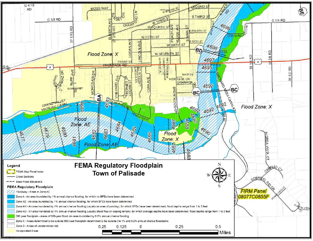
|
Jurisdiction: |
Town of Palisade |
|
||||||||
|---|---|---|---|---|---|---|---|---|---|---|
|
Hazard: |
Rockfalls and Slides |
|||||||||
|
Type of Structure |
Number of Structures |
Value of Structures |
Number of People |
|||||||
|
|
# in Comm. |
# in Hazard Area |
% in Hazard Area |
$ in Comm. |
$ in Hazard Area |
% in Hazard Area |
# in Comm. |
# in Hazard Area |
% in Hazard Area |
|
|
Residential |
1083 |
49 |
4.52% |
$158,831,860.00 |
$7,350,670.00 |
4.63% |
2,741 |
49 |
1.79% |
|
|
Commercial |
80 |
5 |
6.25% |
$18,194,820.00 |
$5,906,850.00 |
32.46% |
||||
|
Agricultural |
32 |
15 |
46.88% |
$4,182,860.00 |
$814,510.00 |
19.47% |
||||
|
Industrial |
4 |
0 |
0.00% |
$804,050.00 |
$ – |
0.00% |
||||
(e) Capabilities Assessment.
|
Local Mitigation Capabilities Tracker for Local and State Plan Updates |
||||
|---|---|---|---|---|
|
|
||||
|
Planning and Regulatory |
Yes/No |
|
Administrative and Technical |
Yes/No |
|
Building Codes |
Yes |
|
Emergency Manager |
Yes |
|
Building Codes Year |
Yes |
|
Floodplain Administrator |
Yes |
|
BCEGS Rating |
Yes |
|
Community Planning: |
|
|
Capital Improvements Program (CIP) or Plan |
Yes |
|
– Planner/Engineer (Land Devel) |
Yes |
|
Community Rating System (CRS) |
No |
|
– Planner/Engineer/Scientist (Natural Hazards) |
Yes |
|
Community Wildfire Protection Plan (CWPP) |
Yes |
|
– Engineer/Professional (Construction) |
Yes |
|
Comprehensive, Master, or General Plan |
Yes |
|
– Resiliency Planner |
Yes |
|
Economic Development Plan |
Yes |
|
– Transportation Planner |
No |
|
Elevation Certificates |
No |
|
Building Official |
Yes |
|
Erosion/Sediment Control Program |
No |
|
GIS Specialist and Capability |
Yes |
|
Floodplain Management Plan or Ordinance |
Yes |
|
Grant Manager, Writer, or Specialist |
Yes |
|
Flood Insurance Study |
No |
|
Warning Systems/Services: |
|
|
Growth Management Ordinance |
No |
|
– General |
No |
|
Non-Flood Hazard-Specific Ordinance or Plan (e.g., Steep Slope, Wildfire, Snow Load) |
No |
|
– Flood |
No |
|
NFIP |
Yes |
|
– Wildfire |
No |
|
Site Plan Review Requirements |
Yes |
|
– Tornado |
No |
|
Stormwater Program, Plan, or Ordinance |
Yes |
|
– Geological Hazards |
No |
|
Zoning Ordinance |
Yes |
|
Other |
|
|
Financial |
Yes/No |
|
Education and Outreach |
Yes/No |
|
Has community used any of the following to fund mitigation activities: |
|
|
Local Citizen Groups That Communicate Hazard Risks |
No |
|
– Levy for Specific Purposes with Voter Approval |
No |
|
Firewise |
Yes |
|
– Utilities Fees |
Yes |
|
StormReady |
No |
|
– System Development/Impact Development Fee |
Yes |
|
Other |
|
|
– General Obligation Bonds to Incur Debt |
Yes |
|
|
|
|
– Special Tax Bonds to Incur Debt |
No |
|
|
|
|
– Withheld Spending in Hazard-Prone Areas |
Yes |
|
|
|
|
– Stormwater Service Fees |
No |
|
|
|
|
– Capital Improvement Project Funding |
Yes |
|
|
|
|
– Community Development Block Grants |
No |
|
|
|
|
– Other |
|
|
|
|
(f) Changes in Development. Changes in development are reflected by the number of building permits issued within a community. The number of building permits issued for the Town of Palisade is reflected in the following table.
|
|
2015 |
2016 |
2017 |
2018 |
2019 |
|---|---|---|---|---|---|
|
Commercial Permits |
0 |
0 |
1 |
1 |
0 |
|
Residential Permits |
5 |
3 |
11 |
7 |
11 |
(Res. 61-20, 10-7-20; Res. 32-15, 7-1-15; Res. 05-10, 1-6-10)
42.08.690 City of Grand Junction.
(a) Community Profile.
Figure 28: City of Grand Junction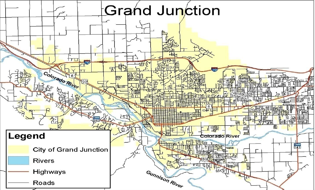
Grand Junction is located on the western slope of the Rocky Mountains in central Mesa County in western Colorado. It is surrounded by the unincorporated areas of Mesa County as seen in Figure 28. It is situated approximately halfway between Salt Lake City, Utah, and Denver, Colorado, and is a regional center for transportation and trade for an area of over 60,000 square miles.
Grand Junction became the center of an extensive mining industry. It continues to be a transportation center for the farming, orchard growing, and livestock industries in the area, as well as a base for various industrial, commercial, and tourism activities. The current population is estimated to be 65,542 (Demographer). The Colorado River originates high in the Rocky Mountains, on the western slope of the Continental Divide. The headwaters, located in Rocky Mountain National Park, are at approximately 12,000 feet. The river flows southwesterly from its headwaters, approximately 200 miles upstream of Grand Junction. At Grand Junction, the river turns to the northwest and continues in that direction through Colorado. The drainage area at Grand Junction is approximately 17,100 square miles.
Grand Junction lies at an elevation of approximately 4,600 feet in the southern part of the Grand Valley, a wide, gently sloping valley defined by high, rock cliffs. To the north, the valley gradually slopes upward for several miles to the base of the Bookcliffs, which rise abruptly to more than 8,000 feet. To the south, Grand Junction is flanked by the Uncompahgre Plateau.
Indian Wash originates at the foot of the Bookcliffs at an elevation of approximately 5,800 feet and flows approximately 5.5 miles southwesterly to an area just northeast of Grand Junction Regional Airport, where the U.S. Soil Conservation Service IW-1 flood detention structure is located. From there it flows generally southerly through the City of Grand Junction to its confluence with the Colorado River.
The climate of Grand Junction is classified as arid to semiarid. The mountainous regions around Grand Junction are subject to moderately heavy precipitation. Elevation greatly influences precipitation amounts. The annual precipitation of Grand Junction averages approximately 8.4 inches; the higher mesas receive from 10 to 20 inches. Occurrence of precipitation is extremely variable with a large part of the total concentrated in several months. Late summer convection type cloudburst storms of small aerial extent and early fall general rain over large areas normally cause August, September, and October to be the wettest months of the year. Most winter precipitation occurs as snow and, in the higher elevations, a deep snowpack generally accumulates. Average snowfall ranges from approximately 19 inches at Grand Junction to approximately 300 inches in the higher mountainous regions. Snowfall is generally dominated by a few large storms. Snowpack ordinarily begins in late October and snowmelt in late April; snowmelt continues through early July.
The temperature extremes at Grand Junction are shown by mean maximums ranging from approximately 38 degrees Fahrenheit in January to approximately 94 degrees Fahrenheit in July, and by mean minimums ranging from approximately 15 degrees Fahrenheit in January to 62 degrees Fahrenheit in July. Record low and high temperatures are minus 34 degrees Fahrenheit and 64 degrees Fahrenheit for January and 38 degrees Fahrenheit and 111 degrees Fahrenheit for July, respectively.
The Colorado River, Indian Wash, and Horizon Drive Channel floodplains are moderately developed with commercial and residential structures. (Flood Insurance Study, Mesa County Colorado, 2009)
(b) Hazard Identification and Profiles. The HMPC identified the hazards that affect the community and summarized their geographic location, probability of future occurrence, potential magnitude or severity, and planning significance specific to the City as shown in Table 22.
|
Hazard Type |
Geographic Location |
Occurrences |
Magnitude/Severity |
Hazard Level |
|---|---|---|---|---|
|
Avalanche |
Isolated |
Unlikely |
Negligible |
L |
|
Drought |
Large |
Occasional |
Limited |
M |
|
Earthquake |
Medium |
Occasional |
Limited |
M |
|
Expansive Soils |
Isolated |
Occasional |
Negligible |
L |
|
Extreme Heat |
Large |
Occasional |
Negligible |
M |
|
Wildfire |
Medium |
Highly Likely |
Limited |
H |
|
Flood |
Large |
Likely |
Limited |
H |
|
Hail Storm |
Small |
Occasional |
Negligible |
L |
|
Land Subsidence |
Isolated |
Occasional |
Limited |
L |
|
Landslide/Rockfall |
Isolated |
Unlikely |
Limited |
L |
|
Lightning |
Medium |
Highly Likely |
Limited |
M |
|
Tornado |
Isolated |
Unlikely |
Negligible |
L |
|
Windstorm |
Medium |
Likely |
Limited |
M |
|
Winter Storm |
Large |
Occasional |
Limited |
M |
|
Dam Failure |
Medium |
Unlikely |
Critical |
M |
|
Hazardous Materials |
Isolated |
Occasional |
Limited |
L |
(c) Vulnerability Assessment. The intent of this section is to assess the City of Grand Junction’s vulnerability separate from that of the planning area as a whole. The vulnerability assessment analyzes the population, property, and other assets at risk to hazards ranked as high significance that may vary from other parts of the planning area and estimates potential losses. These hazards include: wildfire, floods, and rockslides.
(d) Community Asset Inventory. Table 23 shows the total population, number of structures, and assessed value of improvements to parcels in the City of Grand Junction. Land values have been purposely excluded because land remains following disasters, and subsequent market devaluations are frequently short-term and difficult to quantify. Additionally, State and federal disaster assistance programs generally do not address loss of land or its associated value.
|
Jurisdiction: |
City of Grand Junction |
|
||||||||
|---|---|---|---|---|---|---|---|---|---|---|
|
Hazard: |
Wildfire |
|||||||||
|
Type of Structure |
Number of Structures |
Value of Structures |
Number of People |
|||||||
|
|
# in Comm. |
# in Hazard Area |
% in Hazard Area |
$ in Comm. |
$ in Hazard Area |
% in Hazard Area |
# in Comm. |
# in Hazard Area |
% in Hazard Area |
|
|
Residential |
25,630 |
4,433 |
17.30% |
$4,643,888,590.00 |
$998,903,080.00 |
21.51% |
65,542 |
11,188 |
17.07% |
|
|
Commercial |
2,578 |
449 |
17.42% |
$949,567,250.00 |
$107,542,460.00 |
11.33% |
||||
|
Agricultural |
245 |
71 |
28.98% |
$16,694,080.00 |
$3,394,450.00 |
20.33% |
||||
|
Industrial |
595 |
161 |
27.06% |
$202,268,170.00 |
$68,115,230.00 |
33.68% |
||||
|
Jurisdiction: |
City of Grand Junction |
|
|||||||
|---|---|---|---|---|---|---|---|---|---|
|
Hazard: |
Flooding |
||||||||
|
Type of Structure |
Number of Structures |
Value of Structures |
Number of People |
||||||
|
|
# in Comm. |
# in Hazard Area |
% in Hazard Area |
$ in Comm. |
$ in Hazard Area |
% in Hazard Area |
# in Comm. |
# in Hazard Area |
% in Hazard Area |
|
Residential |
25,630 |
316 |
1.23% |
$4,643,888,590.00 |
$42,207,010.00 |
0.91% |
65,542 |
1,351 |
2.06% |
|
Commercial |
2,578 |
50 |
1.94% |
$949,567,250.00 |
$26,894,800.00 |
2.83% |
|||
|
Agricultural |
245 |
3 |
1.22% |
$16,694,080.00 |
$ – |
0.00% |
|||
|
Industrial |
595 |
21 |
3.53% |
$202,268,170.00 |
$11,529,290.00 |
5.70% |
|||
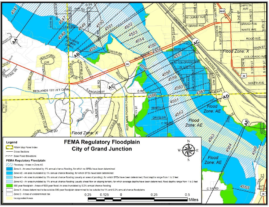
|
Jurisdiction: |
City of Grand Junction |
|
||||||||
|---|---|---|---|---|---|---|---|---|---|---|
|
Hazard: |
Rockfalls and Slides |
|||||||||
|
Type of Structure |
Number of Structures |
Value of Structures |
Number of People |
|||||||
|
|
# in Comm. |
# in Hazard Area |
% in Hazard Area |
$ in Comm. |
$ in Hazard Area |
% in Hazard Area |
# in Comm. |
# in Hazard Area |
% in Hazard Area |
|
|
Residential |
25,630 |
3,237 |
12.63% |
$4,643,888,590.00 |
$866,226,580.00 |
18.65% |
65,542 |
7,785 |
11.88% |
|
|
Commercial |
2,578 |
56 |
2.17% |
$949,567,250.00 |
$16,978,700.00 |
1.79% |
||||
|
Agricultural |
245 |
6 |
2.45% |
$16,694,080.00 |
$2,163,440.00 |
12.96% |
||||
|
Industrial |
595 |
0 |
0.00% |
$202,268,170.00 |
$ – |
0.00% |
||||
(e) Capabilities Assessment.
|
Local Mitigation Capabilities Tracker for Local and State Plan Updates |
||||
|---|---|---|---|---|
|
|
||||
|
Planning and Regulatory |
Yes/No |
|
Administrative and Technical |
Yes/No |
|
Building Codes |
Yes |
|
Emergency Manager |
Yes |
|
Building Codes Year |
Yes |
|
Floodplain Administrator |
Yes |
|
BCEGS Rating |
No |
|
Community Planning: |
|
|
Capital Improvements Program (CIP) or Plan |
Yes |
|
– Planner/Engineer (Land Devel) |
Yes |
|
Community Rating System (CRS) |
No |
|
– Planner/Engineer/Scientist (Natural Hazards) |
Yes |
|
Community Wildfire Protection Plan (CWPP) |
Yes |
|
– Engineer/Professional (Construction) |
Yes |
|
Comprehensive, Master, or General Plan |
Yes |
|
– Resiliency Planner |
No |
|
Economic Development Plan |
Yes |
|
– Transportation Planner |
Yes |
|
Elevation Certificates |
Yes |
|
Building Official |
Yes |
|
Erosion/Sediment Control Program |
Yes |
|
GIS Specialist and Capability |
Yes |
|
Floodplain Management Plan or Ordinance |
Yes |
|
Grant Manager, Writer, or Specialist |
Yes |
|
Flood Insurance Study |
Yes |
|
Warning Systems/Services: |
|
|
Growth Management Ordinance |
Yes |
|
– General |
Yes |
|
Non-Flood Hazard-Specific Ordinance or Plan (e.g., Steep Slope, Wildfire, Snow Load) |
Yes |
|
– Flood |
Yes |
|
NFIP |
Yes |
|
– Wildfire |
Yes |
|
Site Plan Review Requirements |
Yes |
|
– Tornado |
No |
|
Stormwater Program, Plan, or Ordinance |
Yes |
|
– Geological Hazards |
No |
|
Zoning Ordinance |
Yes |
|
Other |
|
|
Financial |
Yes/No |
|
Education and Outreach |
Yes/No |
|
Has community used any of the following to fund mitigation activities: |
|
|
Local Citizen Groups That Communicate Hazard Risks |
No |
|
– Levy for Specific Purposes with Voter Approval |
Yes |
|
Firewise |
No |
|
– Utilities Fees |
Yes |
|
StormReady |
No |
|
– System Development/Impact Development Fee |
Yes |
|
Other |
|
|
– General Obligation Bonds to Incur Debt |
Yes |
|
|
|
|
– Special Tax Bonds to Incur Debt |
Yes |
|
|
|
|
– Withheld Spending in Hazard-Prone Areas |
Yes |
|
|
|
|
– Stormwater Service Fees |
No |
|
|
|
|
– Capital Improvement Project Funding |
Yes |
|
|
|
|
– Community Development Block Grants |
Yes |
|
|
|
|
– Other |
|
|
|
|
(f) Changes in Development. Changes in development are reflected by the number of building permits issued within a community. The number of building permits issued for the City of Grand Junction is reflected in the following table.
|
|
2015 |
2016 |
2017 |
2018 |
2019 |
|---|---|---|---|---|---|
|
Commercial Permits |
15 |
16 |
21 |
32 |
33 |
|
Residential Permits |
270 |
325 |
521 |
525 |
532 |
(Res. 61-20, 10-7-20; Res. 32-15, 7-1-15; Res. 05-10, 1-6-10)
42.08.700 City of Fruita.
(a) Community Profile.
Figure 29: City of Fruita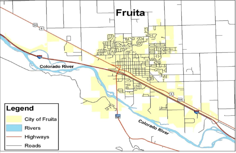
(Source: Mesa County GIS)
The City of Fruita is in northwestern Mesa County. Fruita lies approximately 20 miles east of the Colorado-Utah State boundary and approximately 11 miles west of Grand Junction; see Figure 29. Fruita is surrounded by unincorporated areas of Mesa County. The total land area contained within Fruita is approximately 2.25 square miles. The population of Fruita is estimated to be 13,398. (Demographer)
Fruita has been agriculturally oriented and farming has since become more diversified, with such crops as grains for livestock feed and various fruits and vegetables. Cattle and sheep ranching began as large-scale operations and continue as part of the economic base of the community. There are extensive irrigation facilities in the area to support these activities. Both the Little Salt Wash, Big Salt Wash, and the Colorado River floodplains are developed in Fruita.
Little Salt Wash originates in the Bookcliffs approximately 11 miles north of town, where its headwaters are at approximately 5,100 feet. It flows through the northern corporate limits of Fruita, then forms the western corporate limits of the City as it flows southwesterly to its confluence with the Colorado River. Little Salt Wash and Big Salt Wash flow into the Colorado River approximately 0.5 mile and one mile downstream of Fruita, respectively. The drainage area at Fruita is approximately 33 square miles.
Fruita lies at an elevation of approximately 4,500 feet in the southern part of the Grand Valley. To the north, the valley gradually ascends for several miles to the base of the Bookcliffs. Approximately two miles south of town, the steep sandstone and shale formations of the Colorado National Monument (or the Uncompahgre Uplift) begin. Fruita is part of the Canyon lands, a subdivision of a larger physiographic region known as the Colorado Plateaus.
The climate of Fruita is classified as arid to semiarid. The mountainous regions around Fruita are subject to moderately heavy precipitation. Elevation greatly influences the precipitation amounts. Annual precipitation at Fruita averages approximately nine inches. The higher mesas (headwaters and primary drainage areas of Little Salt Wash and Big Salt Wash) receive from 10 to 20 inches. Convection-type cloudburst storms of small aerial extent and general rainfall over large areas normally make August, September, and October the wettest months of the year. Most wintertime precipitation occurs as snow, and a deep snowpack normally accumulates at the higher elevations. Average snowfall is approximately 19 inches at Fruita.
The temperature extremes at Fruita are evidenced by mean maximums ranging from approximately 38 degrees Fahrenheit in January to approximately 94 degrees Fahrenheit in July, and by mean minimums ranging from approximately 15 degrees Fahrenheit in January to 62 degrees Fahrenheit in July. Record low and high temperatures are minus 34 degrees Fahrenheit and 64 degrees Fahrenheit for January and 38 degrees Fahrenheit and 111 degrees Fahrenheit for July respectively. (Flood Insurance Study, Mesa County Colorado, 2009)
(b) Hazard Identification and Profiles. The HMPC identified the hazards that affect the community and summarized their geographic location, probability of future occurrence, potential magnitude or severity, and planning significance specific to the City as shown in Table 24.
|
Hazard Type |
Geographic Location |
Occurrences |
Magnitude/Severity |
Hazard Level |
|---|---|---|---|---|
|
Avalanche |
Isolated |
Unlikely |
Negligible |
L |
|
Drought |
Large |
Occasional |
Limited |
M |
|
Earthquake |
Medium |
Occasional |
Limited |
M |
|
Expansive Soils |
Isolated |
Occasional |
Negligible |
L |
|
Extreme Heat |
Large |
Occasional |
Limited |
M |
|
Wildfire |
Medium |
Highly Likely |
Limited |
H |
|
Flood |
Large |
Likely |
Limited |
H |
|
Hail Storm |
Small |
Occasional |
Negligible |
L |
|
Land Subsidence |
Isolated |
Occasional |
Limited |
L |
|
Landslide/Rockfall |
Isolated |
Unlikely |
Negligible |
L |
|
Lightning |
Medium |
Highly Likely |
Limited |
M |
|
Tornado |
Isolated |
Unlikely |
Negligible |
L |
|
Windstorm |
Medium |
Likely |
Limited |
M |
|
Winter Storm |
Large |
Occasional |
Limited |
M |
|
Dam Failure |
Medium |
Occasional |
Critical |
M |
|
Hazardous Materials |
Isolated |
Occasional |
Limited |
L |
(c) Vulnerability Assessment. The intent of this section is to assess the City of Fruita’s vulnerability separate from that of the planning area as a whole. The vulnerability assessment analyzes the population, property, and other assets at risk to hazards ranked of moderate or high significance that may vary from other parts of the planning area.
This section analyzes existing structures and other assets at risk to hazards ranked of high significance that vary from the risks facing the entire planning area and estimates potential losses. These hazards include: wildfire, floods, and rockfalls.
(d) Community Asset Inventory. Table 25 shows the total population, number of structures, and assessed value of improvements to parcels in the City of Fruita. Land values have been purposely excluded because land remains following disasters, and subsequent market devaluations are frequently short-term and difficult to quantify. Additionally, State and federal disaster assistance programs generally do not address loss of land or its associated value.
|
Jurisdiction: |
City of Fruita |
|
||||||||
|---|---|---|---|---|---|---|---|---|---|---|
|
Hazard: |
Wildfire |
|||||||||
|
Type of Structure |
Number of Structures |
Value of Structures |
Number of People |
|||||||
|
|
# in Comm. |
# in Hazard Area |
% in Hazard Area |
$ in Comm. |
$ in Hazard Area |
% in Hazard Area |
# in Comm. |
# in Hazard Area |
% in Hazard Area |
|
|
Residential |
5,406 |
1,534 |
23.38% |
$960,865,850.00 |
$299,171,760.00 |
31.14% |
13,398 |
2,991 |
22.32% |
|
|
Commercial |
208 |
9 |
4.33% |
$56,974,680.00 |
$2,270,280.00 |
3.98% |
||||
|
Agricultural |
124 |
61 |
49.19% |
$9,410,310.00 |
$6,167,500.000 |
65.54% |
||||
|
Industrial |
38 |
18 |
47.37% |
$18,392,820.00 |
$15,925,150.00 |
86.58% |
||||
|
Jurisdiction: |
City of Fruita |
|
|||||||
|---|---|---|---|---|---|---|---|---|---|
|
Hazard: |
Flooding |
||||||||
|
Type of Structure |
Number of Structures |
Value of Structures |
Number of People |
||||||
|
|
# in Comm. |
# in Hazard Area |
% in Hazard Area |
$ in Comm. |
$ in Hazard Area |
% in Hazard Area |
# in Comm. |
# in Hazard Area |
% in Hazard Area |
|
Residential |
5,406 |
52 |
0.96% |
$960,865,850.00 |
$6,046,640.00 |
0.63% |
13,398 |
1,116 |
8.33% |
|
Commercial |
208 |
0 |
0.00% |
$56,974,680.00 |
$ – |
0.00% |
|||
|
Agricultural |
124 |
5 |
4.03% |
$9,410,310.00 |
$132,800.00 |
1.41% |
|||
|
Industrial |
38 |
0 |
0.00% |
$18,392,820.00 |
$ – |
0.00% |
|||
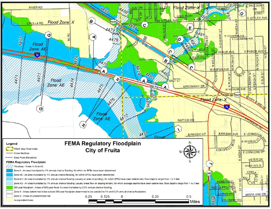
|
Jurisdiction: |
City of Fruita |
|
||||||||
|---|---|---|---|---|---|---|---|---|---|---|
|
Hazard: |
Rockfalls and Slides |
|||||||||
|
Type of Structure |
Number of Structures |
Value of Structures |
Number of People |
|||||||
|
|
# in Comm. |
# in Hazard Area |
% in Hazard Area |
$ in Comm. |
$ in Hazard Area |
% in Hazard Area |
# in Comm. |
# in Hazard Area |
% in Hazard Area |
|
|
Residential |
5,406 |
0 |
0.00% |
$960,865,850.00 |
$ – |
0.00% |
13,398 |
0 |
0.00% |
|
|
Commercial |
208 |
0 |
0.00% |
$56,974,680.00 |
$ – |
0.00% |
||||
|
Agricultural |
124 |
0 |
0.00% |
$9,410,310.00 |
$ – |
0.00% |
||||
|
Industrial |
38 |
0 |
0.00% |
$18,392,820.00 |
$ – |
0.00% |
||||
(e) Capabilities Assessment.
|
Local Mitigation Capabilities Tracker for Local and State Plan Updates |
||||
|---|---|---|---|---|
|
|
||||
|
Planning and Regulatory |
Yes/No |
|
Administrative and Technical |
Yes/No |
|
Building Codes |
Yes |
|
Emergency Manager |
Yes |
|
Building Codes Year |
Yes |
|
Floodplain Administrator |
Yes |
|
BCEGS Rating |
No |
|
Community Planning: |
|
|
Capital Improvements Program (CIP) or Plan |
Yes |
|
– Planner/Engineer (Land Devel) |
Yes |
|
Community Rating System (CRS) |
No |
|
– Planner/Engineer/Scientist (Natural Hazards) |
Yes |
|
Community Wildfire Protection Plan (CWPP) |
Yes |
|
– Engineer/Professional (Construction) |
Yes |
|
Comprehensive, Master, or General Plan |
Yes |
|
– Resiliency Planner |
No |
|
Economic Development Plan |
Yes |
|
– Transportation Planner |
Yes |
|
Elevation Certificates |
Yes |
|
Building Official |
No |
|
Erosion/Sediment Control Program |
No |
|
GIS Specialist and Capability |
Yes |
|
Floodplain Management Plan or Ordinance |
Yes |
|
Grant Manager, Writer, or Specialist |
Yes |
|
Flood Insurance Study |
Yes |
|
Warning Systems/Services: |
|
|
Growth Management Ordinance |
Yes |
|
– General |
Yes |
|
Non-Flood Hazard-Specific Ordinance or Plan (e.g., Steep Slope, Wildfire, Snow Load) |
No |
|
– Flood |
Yes |
|
NFIP |
Yes |
|
– Wildfire |
Yes |
|
Site Plan Review Requirements |
Yes |
|
– Tornado |
Yes |
|
Stormwater Program, Plan, or Ordinance |
Yes |
|
– Geological Hazards |
Yes |
|
Zoning Ordinance |
Yes |
|
Other |
|
|
Financial |
Yes/No |
|
Education and Outreach |
Yes/No |
|
Has community used any of the following to fund mitigation activities: |
|
|
Local Citizen Groups That Communicate Hazard Risks |
No |
|
– Levy for Specific Purposes with Voter Approval |
No |
|
Firewise |
No |
|
– Utilities Fees |
Yes |
|
StormReady |
No |
|
– System Development/Impact Development Fee |
No |
|
Other |
|
|
– General Obligation Bonds to Incur Debt |
Yes |
|
|
|
|
– Special Tax Bonds to Incur Debt |
No |
|
|
|
|
– Withheld Spending in Hazard-Prone Areas |
No |
|
|
|
|
– Stormwater Service Fees |
No |
|
|
|
|
– Capital Improvement Project Funding |
Yes |
|
|
|
|
– Community Development Block Grants |
No |
|
|
|
|
– Other |
|
|
|
|
(f) Changes in Development. Changes in development are reflected by the number of building permits issued within a community. The number of building permits issued for the City of Fruita is reflected in the following table.
|
|
2015 |
2016 |
2017 |
2018 |
2019 |
|---|---|---|---|---|---|
|
Commercial Permits |
2 |
3 |
1 |
4 |
4 |
|
Residential Permits |
39 |
64 |
49 |
109 |
71 |
(Res. 61-20, 10-7-20; Res. 32-15, 7-1-15; Res. 05-10, 1-6-10)
42.08.705 Town of DeBeque.
(a) Community Profile.
Figure 30: Town of DeBeque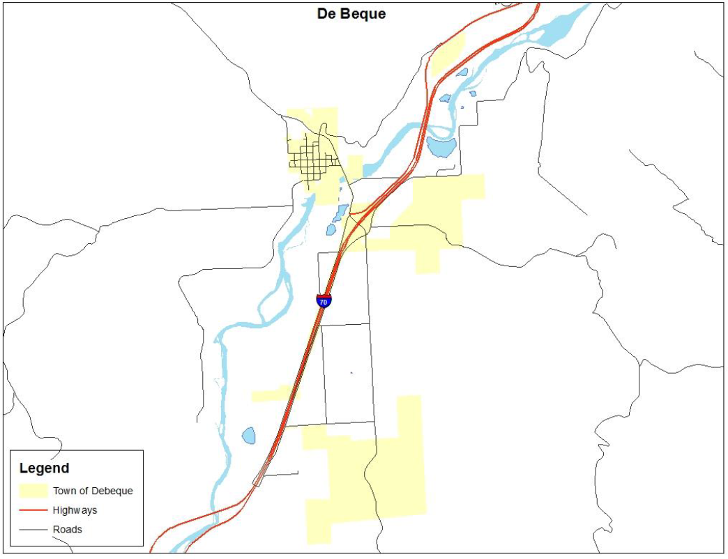
(Source: Mesa County GIS)
The Town of DeBeque sits along the north side of the Colorado River upstream from DeBeque Canyon in a small ranching valley northeast and upstream from Grand Junction; see Figure 30. The Town is located across the river from Interstate 70, on a small hill overlooking the river, at an elevation of approximately 5,000 feet. The southwest edge of the Roan Cliffs overlooks the town from the northeast. Much of the surrounding area is controlled by the Bureau of Land Management.
The major underlying geological formation is the Wasatch Formation, a system of intermixed shales and sandstones which form the hills to the northwest. Overlying the Wasatch Formation and forming the bulk of the Roan Plateau to the northwest is the Green River Formation. This formation reportedly contains major deposits of oil shale.
The town consists of a small grid (approximately 0.3 square miles), including several historic buildings, commercial, and residential. DeBeque was historically a location where wild horses, abundant in the surrounding hills, were rounded up and sold. The population of DeBeque is estimated to be 502. (Demographer)
(b) Hazard Identification and Profiles. The HMPC identified the hazards that affect the community and summarized their geographic location, probability of future occurrence, potential magnitude or severity, and planning significance specific to the Town as shown in Table 26.
|
Hazard Type |
Geographic Location |
Occurrences |
Magnitude/Severity |
Hazard Level |
|---|---|---|---|---|
|
Avalanche |
Isolated |
Unlikely |
Negligible |
L |
|
Drought |
Large |
Occasional |
Limited |
M |
|
Earthquake |
Medium |
Occasional |
Limited |
M |
|
Expansive Soils |
Medium |
Occasional |
Limited |
L |
|
Extreme Heat |
Large |
Occasional |
Limited |
M |
|
Wildfire |
Medium |
Highly Likely |
Limited |
H |
|
Flood |
Large |
Likely |
Limited |
H |
|
Hail Storm |
Small |
Occasional |
Negligible |
L |
|
Land Subsidence |
Isolated |
Occasional |
Limited |
L |
|
Landslide/Rockfall |
Isolated |
Unlikely |
Negligible |
L |
|
Lightning |
Medium |
Highly Likely |
Limited |
M |
|
Tornado |
Isolated |
Unlikely |
Negligible |
L |
|
Windstorm |
Medium |
Likely |
Limited |
M |
|
Winter Storm |
Large |
Occasional |
Limited |
M |
|
Dam Failure |
Medium |
Occasional |
Critical |
M |
|
Hazardous Materials |
Isolated |
Occasional |
Limited |
L |
(c) Vulnerability Assessment. The intent of this section is to assess the Town of DeBeque’s vulnerability separate from that of the planning area as a whole. The vulnerability assessment analyzes the population, property, and other assets at risk to hazards ranked of moderate or high significance that may vary from other parts of the planning area.
This section analyzes existing structures and other assets at risk to hazards ranked of high significance that vary from the risks facing the entire planning area and estimates potential losses. These hazards include: wildfire and floods. Wildfire and flood are perceived as high risk in the community because of oil and gas resources in the area and the impact wildfire and flood have on these resources.
(d) Community Asset Inventory. Table 27 shows the total population, number of structures, and assessed value of improvements to parcels in the Town of DeBeque. Land values have been purposely excluded because land remains following disasters, and subsequent market devaluations are frequently short-term and difficult to quantify. Additionally, State and federal disaster assistance programs generally do not address loss of land or its associated value.
|
Jurisdiction: |
Town of DeBeque |
|
||||||||
|---|---|---|---|---|---|---|---|---|---|---|
|
Hazard: |
Wildfire |
|||||||||
|
Type of Structure |
Number of Structures |
Value of Structures |
Number of People |
|||||||
|
|
# in Comm. |
# in Hazard Area |
% in Hazard Area |
$ in Comm. |
$ in Hazard Area |
% in Hazard Area |
# in Comm. |
# in Hazard Area |
% in Hazard Area |
|
|
Residential |
268 |
0 |
0.00% |
$18,141,040.00 |
$ – |
0.00% |
502 |
98 |
19.52% |
|
|
Commercial |
29 |
0 |
0.00% |
$6,018,410.00 |
$ – |
0.00% |
||||
|
Agricultural |
24 |
4 |
16.67% |
$244,680.00 |
$ – |
0.00% |
||||
|
Industrial |
2 |
1 |
50.00% |
$264,260.00 |
$29,720.00 |
11.25% |
||||
|
Jurisdiction: |
Town of DeBeque |
|
|||||||
|---|---|---|---|---|---|---|---|---|---|
|
Hazard: |
Flooding |
||||||||
|
Type of Structure |
Number of Structures |
Value of Structures |
Number of People |
||||||
|
|
# in Comm. |
# in Hazard Area |
% in Hazard Area |
$ in Comm. |
$ in Hazard Area |
% in Hazard Area |
# in Comm. |
# in Hazard Area |
% in Hazard Area |
|
Residential |
268 |
8 |
2.99% |
$18,141,040.00 |
$ – |
0.00% |
502 |
0 |
0.00% |
|
Commercial |
29 |
1 |
3.45% |
$6,018,410.00 |
$1,253,100.00 |
20.82% |
|||
|
Agricultural |
24 |
0 |
0.00% |
$244,680.00 |
$ – |
0.00% |
|||
|
Industrial |
2 |
0 |
0.00% |
$264,260.00 |
$ – |
0.00% |
|||
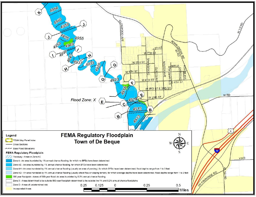
|
Jurisdiction: |
Town of DeBeque |
|
||||||||
|---|---|---|---|---|---|---|---|---|---|---|
|
Hazard: |
Rockfalls and Slides |
|||||||||
|
Type of Structure |
Number of Structures |
Value of Structures |
Number of People |
|||||||
|
|
# in Comm. |
# in Hazard Area |
% in Hazard Area |
$ in Comm. |
$ in Hazard Area |
% in Hazard Area |
# in Comm. |
# in Hazard Area |
% in Hazard Area |
|
|
Residential |
268 |
0 |
0.00% |
$18,141,040.00 |
$ – |
0.00% |
502 |
0 |
0.00% |
|
|
Commercial |
29 |
0 |
0.00% |
$6,018,410.00 |
$ – |
0.00% |
||||
|
Agricultural |
24 |
0 |
0.00% |
$244,680.00 |
$ – |
0.00% |
||||
|
Industrial |
2 |
0 |
0.00% |
$264,260.00 |
$ – |
0.00% |
||||
(e) Capabilities Assessment.
|
Local Mitigation Capabilities Tracker for Local and State Plan Updates |
||||
|---|---|---|---|---|
|
|
||||
|
Planning and Regulatory |
Yes/No |
|
Administrative and Technical |
Yes/No |
|
Building Codes |
Yes |
|
Emergency Manager |
No |
|
Building Codes Year |
Yes |
|
Floodplain Administrator |
No |
|
BCEGS Rating |
No |
|
Community Planning: |
|
|
Capital Improvements Program (CIP) or Plan |
Yes |
|
– Planner/Engineer (Land Devel) |
Yes |
|
Community Rating System (CRS) |
No |
|
– Planner/Engineer/Scientist (Natural Hazards) |
No |
|
Community Wildfire Protection Plan (CWPP) |
Yes |
|
– Engineer/Professional (Construction) |
No |
|
Comprehensive, Master, or General Plan |
Yes |
|
– Resiliency Planner |
No |
|
Economic Development Plan |
Yes |
|
– Transportation Planner |
No |
|
Elevation Certificates |
Yes |
|
Building Official |
No |
|
Erosion/Sediment Control Program |
No |
|
GIS Specialist and Capability |
No |
|
Floodplain Management Plan or Ordinance |
Yes |
|
Grant Manager, Writer, or Specialist |
No |
|
Flood Insurance Study |
No |
|
Warning Systems/Services: |
|
|
Growth Management Ordinance |
Yes |
|
– General |
No |
|
Non-Flood Hazard-Specific Ordinance or Plan (e.g., Steep Slope, Wildfire, Snow Load) |
No |
|
– Flood |
No |
|
NFIP |
Yes |
|
– Wildfire |
No |
|
Site Plan Review Requirements |
Yes |
|
– Tornado |
No |
|
Stormwater Program, Plan, or Ordinance |
No |
|
– Geological Hazards |
No |
|
Zoning Ordinance |
Yes |
|
Other |
|
|
Financial |
Yes/No |
|
Education and Outreach |
Yes/No |
|
Has community used any of the following to fund mitigation activities: |
|
|
Local Citizen Groups That Communicate Hazard Risks |
No |
|
– Levy for Specific Purposes with Voter Approval |
No |
|
Firewise |
No |
|
– Utilities Fees |
Yes |
|
StormReady |
No |
|
– System Development/Impact Development Fee |
Yes |
|
Other |
|
|
– General Obligation Bonds to Incur Debt |
Yes |
|
|
|
|
– Special Tax Bonds to Incur Debt |
No |
|
|
|
|
– Withheld Spending in Hazard-Prone Areas |
No |
|
|
|
|
– Stormwater Service Fees |
No |
|
|
|
|
– Capital Improvement Project Funding |
No |
|
|
|
|
– Community Development Block Grants |
No |
|
|
|
|
– Other |
|
|
|
|
(f) Changes in Development. Changes in development are reflected by the number of building permits issued within a community. The number of building permits issued for the Town of DeBeque is reflected in the following table.
|
|
2015 |
2016 |
2017 |
2018 |
2019 |
|---|---|---|---|---|---|
|
Commercial Permits |
0 |
1 |
1 |
0 |
1 |
|
Residential Permits |
2 |
2 |
0 |
2 |
1 |
(Res. 61-20, 10-7-20; Res. 32-15, 7-1-15)
42.08.710 Fire protection districts.
(a) District Profile. The material presented in this section applies to five fire protection districts in Mesa County, which are described below. Each of the districts participated individually in this planning process. Figure 31 shows all fire districts in Mesa County.
Figure 31: Fire Protection Districts in Mesa County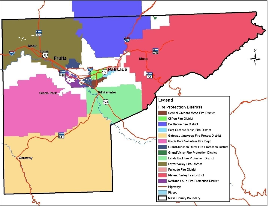
(b) Plateau Valley Fire Protection District. The Plateau Valley Fire Protection District (PVFPD) covers an area of 803 square miles as shown in Figure 32, with a residential population of approximately 4,000 people. The district operates out of three fire stations with approximately 30 volunteers.
Figure 32: Plateau Valley FPD Boundary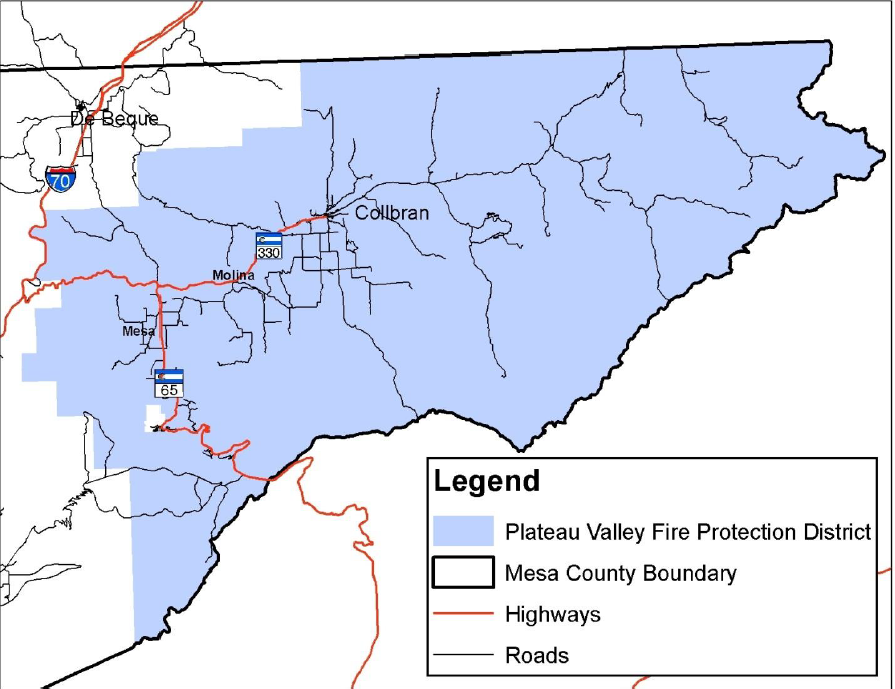
|
Local Mitigation Capabilities Tracker for Local and State Plan Updates |
||||
|---|---|---|---|---|
|
|
||||
|
Planning and Regulatory |
Yes/No |
|
Administrative and Technical |
Yes/No |
|
Building Codes |
No |
|
Emergency Manager |
No |
|
Building Codes Year |
N/A |
|
Floodplain Administrator |
No |
|
BCEGS Rating |
No |
|
Community Planning: |
|
|
Capital Improvements Program (CIP) or Plan |
Yes |
|
– Planner/Engineer (Land Devel) |
No |
|
Community Rating System (CRS) |
No |
|
– Planner/Engineer/Scientist (Natural Hazards) |
No |
|
Community Wildfire Protection Plan (CWPP) |
Yes |
|
– Engineer/Professional (Construction) |
No |
|
Comprehensive, Master, or General Plan |
No |
|
– Resiliency Planner |
No |
|
Economic Development Plan |
No |
|
– Transportation Planner |
No |
|
Elevation Certificates |
No |
|
Building Official |
No |
|
Erosion/Sediment Control Program |
No |
|
GIS Specialist and Capability |
No |
|
Floodplain Management Plan or Ordinance |
No |
|
Grant Manager, Writer, or Specialist |
No |
|
Flood Insurance Study |
No |
|
Warning Systems/Services: |
|
|
Growth Management Ordinance |
No |
|
– General |
No |
|
Non-Flood Hazard-Specific Ordinance or Plan (e.g., Steep Slope, Wildfire, Snow Load) |
Yes |
|
– Flood |
No |
|
NFIP |
No |
|
– Wildfire |
No |
|
Site Plan Review Requirements |
Yes |
|
– Tornado |
No |
|
Stormwater Program, Plan, or Ordinance |
No |
|
– Geological Hazards (West Salt Creek Landslide) |
No |
|
Zoning Ordinance |
No |
|
Other |
|
|
Financial |
Yes/No |
|
Education and Outreach |
Yes/No |
|
Has community used any of the following to fund mitigation activities: |
|
|
Local Citizen Groups That Communicate Hazard Risks |
Yes |
|
– Levy for Specific Purposes with Voter Approval |
No |
|
Firewise |
Yes |
|
– Utilities Fees |
No |
|
StormReady |
No |
|
– System Development/Impact Development Fee |
No |
|
Other |
|
|
– General Obligation Bonds to Incur Debt |
No |
|
|
|
|
– Special Tax Bonds to Incur Debt |
No |
|
|
|
|
– Withheld Spending in Hazard-Prone Areas |
No |
|
|
|
|
– Stormwater Service Fees |
No |
|
|
|
|
– Capital Improvement Project Funding |
No |
|
|
|
|
– Community Development Block Grants |
No |
|
|
|
|
– Other (Wildfire Mitigation Grant) |
Yes |
|
|
|
The Plateau Valley Fire Protection District has facilities in the wildland-urban interface and the floodplain.
(c) Lower Valley Fire Protection District. The Lower Valley Fire Protection District (LVFPD) and the City of Fruita organized a fire district in 1973. The district split from the City and in 1980 became its own separate district. Both volunteer and paid positions make up the district and provide fire protection as well as emergency medical services.
Population of the district is approximately 20,000. LVFPD operates out of two fire stations: Station 31 is located in Fruita and houses three ambulances, two engines, two brush trucks, one water tender, one river boat and two ATVs. Station 32 is five miles to the west in Loma and houses one water tender, one ladder, one rescue and the antique fire truck.
Coverage of the district amounts to approximately 225 square miles ranging from the City limits of Grand Junction on the east side and the Utah State border on the west side as shown in Figure 33. This area covers the Colorado National Monument to the south and continuing north to Douglas Pass in Garfield County. The District has a variety of terrain ranging from desert to heavy timber and rural residential to a small downtown commercial district. (Home: Lower Valley Fire Protection District, 2009)
Figure 33: Lower Valley Fire Protection District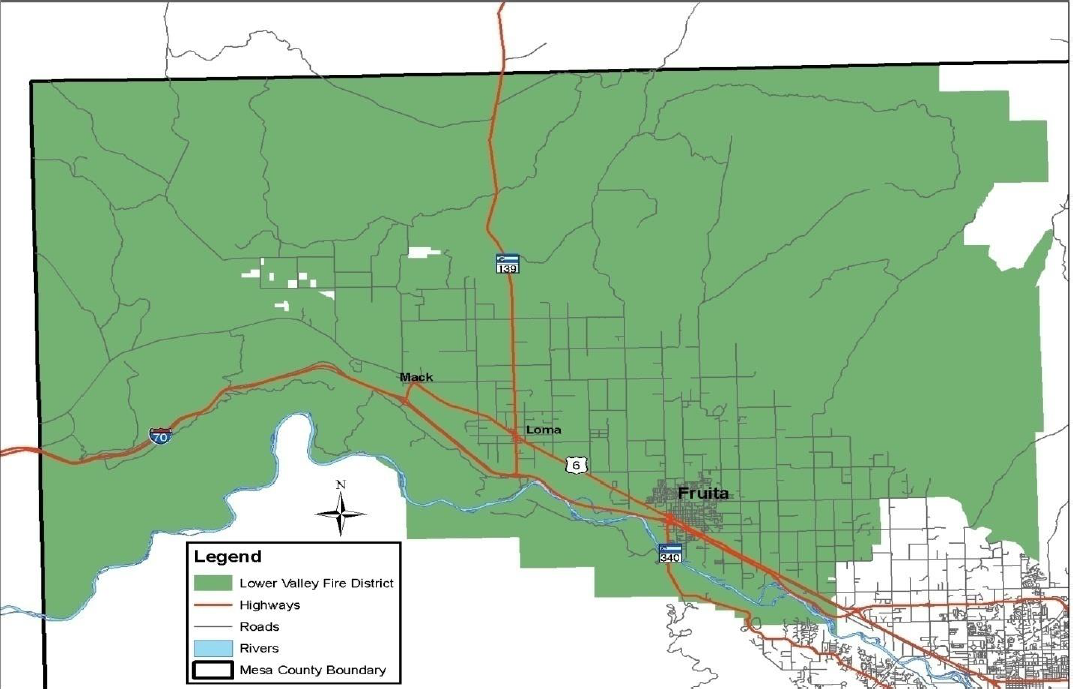
|
Local Mitigation Capabilities Tracker for Local and State Plan Updates |
||||
|---|---|---|---|---|
|
|
||||
|
Planning and Regulatory |
Yes/No |
|
Administrative and Technical |
Yes/No |
|
Building Codes |
Yes |
|
Emergency Manager |
No |
|
Building Codes Year |
Yes |
|
Floodplain Administrator |
No |
|
BCEGS Rating |
No |
|
Community Planning: |
|
|
Capital Improvements Program (CIP) or Plan |
Yes |
|
– Planner/Engineer (Land Devel) |
No |
|
Community Rating System (CRS) |
No |
|
– Planner/Engineer/Scientist (Natural Hazards) |
No |
|
Community Wildfire Protection Plan (CWPP) |
Yes |
|
– Engineer/Professional (Construction) |
No |
|
Comprehensive, Master, or General Plan |
No |
|
– Resiliency Planner |
No |
|
Economic Development Plan |
No |
|
– Transportation Planner |
No |
|
Elevation Certificates |
No |
|
Building Official |
No |
|
Erosion/Sediment Control Program |
No |
|
GIS Specialist and Capability |
No |
|
Floodplain Management Plan or Ordinance |
No |
|
Grant Manager, Writer, or Specialist |
No |
|
Flood Insurance Study |
No |
|
Warning Systems/Services: |
|
|
Growth Management Ordinance |
No |
|
– General |
No |
|
Non-Flood Hazard-Specific Ordinance or Plan (e.g., Steep Slope, Wildfire, Snow Load) |
No |
|
– Flood |
No |
|
NFIP |
No |
|
– Wildfire |
No |
|
Site Plan Review Requirements |
No |
|
– Tornado |
No |
|
Stormwater Program, Plan, or Ordinance |
No |
|
– Geological Hazards |
No |
|
Zoning Ordinance |
No |
|
Other |
|
|
Financial |
Yes/No |
|
Education and Outreach |
Yes/No |
|
Has community used any of the following to fund mitigation activities: |
|
|
Local Citizen Groups That Communicate Hazard Risks |
No |
|
– Levy for Specific Purposes with Voter Approval |
Yes |
|
Firewise |
Yes |
|
– Utilities Fees |
No |
|
StormReady |
No |
|
– System Development/Impact Development Fee |
No |
|
Other |
|
|
– General Obligation Bonds to Incur Debt |
No |
|
|
|
|
– Special Tax Bonds to Incur Debt |
No |
|
|
|
|
– Withheld Spending in Hazard-Prone Areas |
No |
|
|
|
|
– Stormwater Service Fees |
No |
|
|
|
|
– Capital Improvement Project Funding |
No |
|
|
|
|
– Community Development Block Grants |
Yes |
|
|
|
|
– Other |
|
|
|
|
Lower Valley Fire Protection District has facilities in close proximity to rail line and the Interstate making their facilities vulnerable to hazardous materials incidents. While their facilities are not directly impacted by flooding, access routes to their facilities are.
(d) Grand Junction Fire Department and Grand Junction Rural Fire Protection District. The Grand Junction Fire Department is an emergency organization that provides education, enforcement and emergency services to over 84,000 residents living within the City of Grand Junction and the Grand Junction Rural Fire Protection District. The Grand Junction Rural Fire Protection District is a taxing district surrounding the City limits which contracts with the City of Grand Junction to provide these services. Grand Junction Fire Department serves a total of 77 square miles with five stations and 120 full-time personnel as shown in Figure 34.
Figure 34: Grand Junction Fire Department and Grand Junction Rural Fire Protection District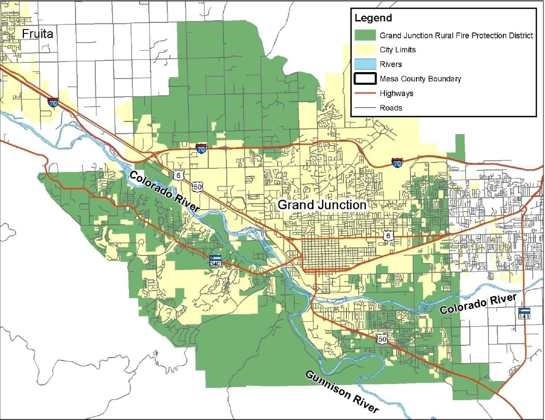
|
Local Mitigation Capabilities Tracker for Local and State Plan Updates |
||||
|---|---|---|---|---|
|
|
||||
|
Planning and Regulatory |
Yes/No |
|
Administrative and Technical |
Yes/No |
|
Building Codes |
Yes |
|
Emergency Manager |
Yes |
|
Building Codes Year |
Yes |
|
Floodplain Administrator |
No |
|
BCEGS Rating |
No |
|
Community Planning: |
|
|
Capital Improvements Program (CIP) or Plan |
Yes |
|
– Planner/Engineer (Land Devel) |
No |
|
Community Rating System (CRS) |
No |
|
– Planner/Engineer/Scientist (Natural Hazards) |
No |
|
Community Wildfire Protection Plan (CWPP) |
Yes |
|
– Engineer/Professional (Construction) |
No |
|
Comprehensive, Master, or General Plan |
Yes |
|
– Resiliency Planner |
No |
|
Economic Development Plan |
No |
|
– Transportation Planner |
No |
|
Elevation Certificates |
No |
|
Building Official |
No |
|
Erosion/Sediment Control Program |
No |
|
GIS Specialist and Capability |
No |
|
Floodplain Management Plan or Ordinance |
No |
|
Grant Manager, Writer, or Specialist |
No |
|
Flood Insurance Study |
No |
|
Warning Systems/Services: |
|
|
Growth Management Ordinance |
No |
|
– General |
No |
|
Non-Flood Hazard-Specific Ordinance or Plan (e.g., Steep Slope, Wildfire, Snow Load) |
No |
|
– Flood |
No |
|
NFIP |
No |
|
– Wildfire |
No |
|
Site Plan Review Requirements |
No |
|
– Tornado |
No |
|
Stormwater Program, Plan, or Ordinance |
No |
|
– Geological Hazards |
No |
|
Zoning Ordinance |
No |
|
Other |
|
|
Financial |
Yes/No |
|
Education and Outreach |
Yes/No |
|
Has community used any of the following to fund mitigation activities: |
|
|
Local Citizen Groups That Communicate Hazard Risks |
No |
|
– Levy for Specific Purposes with Voter Approval |
No |
|
Firewise |
No |
|
– Utilities Fees |
No |
|
StormReady |
No |
|
– System Development/Impact Development Fee |
No |
|
Other |
|
|
– General Obligation Bonds to Incur Debt |
No |
|
|
|
|
– Special Tax Bonds to Incur Debt |
No |
|
|
|
|
– Withheld Spending in Hazard-Prone Areas |
No |
|
|
|
|
– Stormwater Service Fees |
No |
|
|
|
|
– Capital Improvement Project Funding |
No |
|
|
|
|
– Community Development Block Grants |
No |
|
|
|
|
– Other |
|
|
|
|
The District has facilities located in the wildland urban interface and within the flood zone.
(e) DeBeque Fire Protection District. The DeBeque Fire Protection District covers an area of 800 square miles shown in Figure 35, with a residential population of approximately 1,298 people, which includes district population residing in Garfield County. The district operates out of a single fire station with seven full-time and six part-time paid staff.
Figure 35: DeBeque Fire Protection District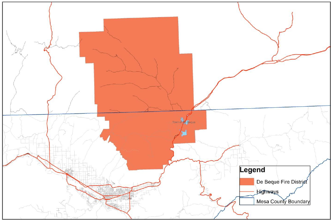
|
Local Mitigation Capabilities Tracker for Local and State Plan Updates |
||||
|---|---|---|---|---|
|
|
||||
|
Planning and Regulatory |
Yes/No |
|
Administrative and Technical |
Yes/No |
|
Building Codes |
Yes |
|
Emergency Manager |
No |
|
Building Codes Year |
No |
|
Floodplain Administrator |
No |
|
BCEGS Rating |
No |
|
Community Planning: |
|
|
Capital Improvements Program (CIP) or Plan |
No |
|
– Planner/Engineer (Land Devel) |
No |
|
Community Rating System (CRS) |
No |
|
– Planner/Engineer/Scientist (Natural Hazards) |
No |
|
Community Wildfire Protection Plan (CWPP) |
No |
|
– Engineer/Professional (Construction) |
No |
|
Comprehensive, Master, or General Plan |
No |
|
– Resiliency Planner |
No |
|
Economic Development Plan |
No |
|
– Transportation Planner |
No |
|
Elevation Certificates |
No |
|
Building Official |
No |
|
Erosion/Sediment Control Program |
No |
|
GIS Specialist and Capability |
No |
|
Floodplain Management Plan or Ordinance |
No |
|
Grant Manager, Writer, or Specialist |
No |
|
Flood Insurance Study |
No |
|
Warning Systems/Services: |
|
|
Growth Management Ordinance |
No |
|
– General |
No |
|
Non-Flood Hazard-Specific Ordinance or Plan (e.g., Steep Slope, Wildfire, Snow Load) |
No |
|
– Flood |
No |
|
NFIP |
No |
|
– Wildfire |
No |
|
Site Plan Review Requirements |
No |
|
– Tornado |
No |
|
Stormwater Program, Plan, or Ordinance |
No |
|
– Geological Hazards |
No |
|
Zoning Ordinance |
No |
|
Other |
|
|
Financial |
Yes/No |
|
Education and Outreach |
Yes/No |
|
Has community used any of the following to fund mitigation activities: |
|
|
Local Citizen Groups That Communicate Hazard Risks |
No |
|
– Levy for Specific Purposes with Voter Approval |
No |
|
Firewise |
Yes |
|
– Utilities Fees |
No |
|
StormReady |
No |
|
– System Development/Impact Development Fee |
No |
|
Other |
|
|
– General Obligation Bonds to Incur Debt |
No |
|
|
|
|
– Special Tax Bonds to Incur Debt |
No |
|
|
|
|
– Withheld Spending in Hazard-Prone Areas |
No |
|
|
|
|
– Stormwater Service Fees |
No |
|
|
|
|
– Capital Improvement Project Funding |
No |
|
|
|
|
– Community Development Block Grants |
No |
|
|
|
|
– Other |
|
|
|
|
The District has facilities adjacent to the interstate that are vulnerable to hazardous materials incidents.
(f) Clifton Fire Protection District. The Clifton Fire Protection District was formed in 1943 and the Fire Protection District boundaries are from 30 Road East to 35 Road, the Colorado River North to I-70. It encompasses approximately 15 square miles. The District is governed by a Board of Directors that are elected from the property owners that reside in the Fire District.
The Clifton Fire Protection District has two front line 1,500 GPM pumpers, a 75-foot ladder truck, one rescue/air/light truck, three ambulances, and one rescue boat.
Figure 36: Clifton Fire Protection District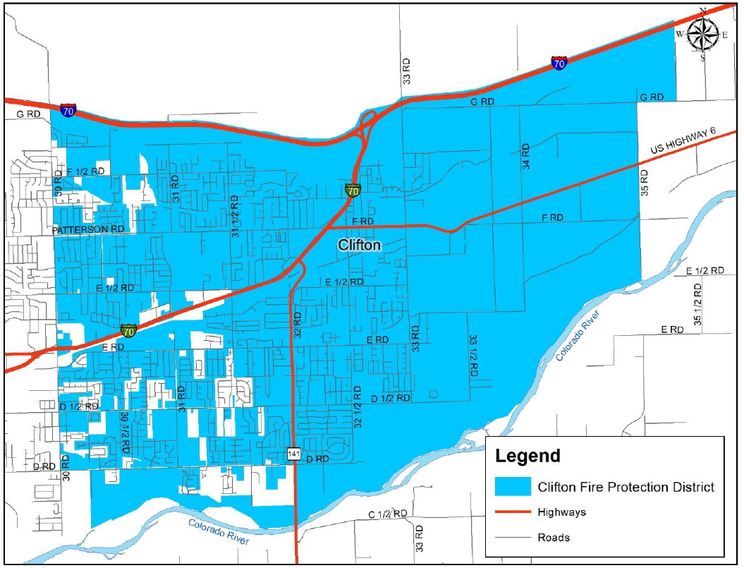
|
Local Mitigation Capabilities Tracker for Local and State Plan Updates |
||||
|---|---|---|---|---|
|
|
||||
|
Planning and Regulatory |
Yes/No |
|
Administrative and Technical |
Yes/No |
|
Building Codes |
Yes |
|
Emergency Manager |
Yes |
|
Building Codes Year |
Yes |
|
Floodplain Administrator |
No |
|
BCEGS Rating |
3/3 X |
|
Community Planning: |
|
|
Capital Improvements Program (CIP) or Plan |
Yes |
|
– Planner/Engineer (Land Devel) |
No |
|
Community Rating System (CRS) |
No |
|
– Planner/Engineer/Scientist (Natural Hazards) |
No |
|
Community Wildfire Protection Plan (CWPP) |
Yes |
|
– Engineer/Professional (Construction) |
No |
|
Comprehensive, Master, or General Plan |
Yes |
|
– Resiliency Planner |
No |
|
Economic Development Plan |
Yes |
|
– Transportation Planner |
No |
|
Elevation Certificates |
No |
|
Building Official |
No |
|
Erosion/Sediment Control Program |
No |
|
GIS Specialist and Capability |
No |
|
Floodplain Management Plan or Ordinance |
No |
|
Grant Manager, Writer, or Specialist |
No |
|
Flood Insurance Study |
No |
|
Warning Systems/Services: |
|
|
Growth Management Ordinance |
No |
|
– General |
No |
|
Non-Flood Hazard-Specific Ordinance or Plan (e.g., Steep Slope, Wildfire, Snow Load) |
No |
|
– Flood |
No |
|
NFIP |
No |
|
– Wildfire |
No |
|
Site Plan Review Requirements |
Yes |
|
– Tornado |
No |
|
Stormwater Program, Plan, or Ordinance |
No |
|
– Geological Hazards |
No |
|
Zoning Ordinance |
No |
|
Other |
|
|
Financial |
Yes/No |
|
Education and Outreach |
Yes/No |
|
Has community used any of the following to fund mitigation activities: |
|
|
Local Citizen Groups That Communicate Hazard Risks |
No |
|
– Levy for Specific Purposes with Voter Approval |
Yes |
|
Firewise |
No |
|
– Utilities Fees |
No |
|
StormReady |
No |
|
– System Development/Impact Development Fee |
No |
|
Other |
|
|
– General Obligation Bonds to Incur Debt |
No |
|
|
|
|
– Special Tax Bonds to Incur Debt |
No |
|
|
|
|
– Withheld Spending in Hazard-Prone Areas |
No |
|
|
|
|
– Stormwater Service Fees |
No |
|
|
|
|
– Capital Improvement Project Funding |
Yes |
|
|
|
|
– Community Development Block Grants |
No |
|
|
|
|
– Other |
|
|
|
|
The District has facilities at the junction of I-70B and Highway 6 that are vulnerable to hazardous materials incidents.
(g) Hazard Identification and Profiles. As population continues to grow in Mesa County, development continues in the wildland-urban interface areas, increasing the risk of wildfires. Continued assessments and mitigation efforts are needed throughout the County to reduce the risk and impacts to communities. More detailed analysis has been done for the specific communities and can be found in those sections.
(Res. 61-20, 10-7-20; Res. 32-15, 7-1-15; Res. 05-10, 1-6-10)
42.08.720 5-2-1 Drainage Authority.
Repealed by Res. 61-20.
(Res. 32-15, 7-1-15; Res. 05-10, 1-6-10)
42.08.730 Works cited.
About Us: Colorado Natural Heritage Program. (2009). Retrieved October 21, 2009, from Colorado Natural Heritage Program: http://www.cnhp.colostate.edu
County, M. (2009, July 28). Mesa County Planning and Economic Development. Retrieved November 12, 2009, from Mesa County: http://www.mesacounty.us
County, M. (2009, March 24). Mesa County Public Works, Stormwater Management. Retrieved November 12, 2009, from Mesa County: http://www.mesacounty.us
Data and Demographics: Grand Junction Economic Partnership. (2009). Retrieved October 26, 2009, from Grand Junction Economic Partnership: http://www.gjep.org/
Demographer, S. (n.d.). State Demography Office. Retrieved November 2, 2009, from Colorado Division of Local Government: http://dola.colorado.gov
Department of Geography, U. o. (2009, August 26). Hazards and Vulnerability Research Institute. Retrieved September 14, 2009, from SHELDUS: http://webra.cas.sc.edu
EHP Web Team. (2009, September 14). Welcome to the U.S. Geological Survey Earthquake Hazards Program. Retrieved September 14, 2009, from USGS: http://earthquake.usgs.gov/
Englehart, C. (2014). Mesa County Workforce Director. Grand Junction, CO, USA.
FEMA. (2009, July 9). Getting Started: Building Support for Mitigation Planning FEMA 386-1. Retrieved October 28, 2009, from Federal Emergency Management Agency: http://www.fema.gov
FEMA. (2007, October 31). Hazard Mitigation Planning and Hazard Mitigation Grant Program. Final Rule. Retrieved October 28, 2009, from Federal Emergency Management Agency: http://www.fema.gov
FEMA. (2009, November 13). HAZUS-MH.
FEMA. (2006). Introduction to Hazard Mitigation. FEMA IS 393. Retrieved October 28, 2009, from Federal Emergency Management Agency: http://www.fema.gov
FEMA. (2009). Multi-Hazard Identification and Risk Assessment. Retrieved October 28, 2009, from Federal Emergency Management Agency: http://www.fema.gov/library/viewRecord.do
FEMA. (2009, July 9). Multi-Hazard Mitigation Planning. FEMA 386-8. Retrieved October 28, 2009, from Federal Emergency Management Agency: http://www.fema.gov
FEMA. (2001, September). Understanding Your Risks: Identify Hazards and Estimating Losses. FEMA 386-2. Retrieved October 28, 2009, from Federal Emergency Management Agency: http://www.fema.gov
FEMA. (2001). Understanding Your Risks: Identifying Hazards and Estimating Losses. FEMA 386-2. Retrieved October 28, 2009, from Federal Emergency Management Agency: http://www.fema.gov
FEMA. (2009). Flood Insurance Study, Mesa County Colorado. FEMA.
Hampton, R. (2009, October 28). Division of Wildlife, Public Information Officer, Northwest Region. Grand Junction, CO, USA.
Hinson, S. (2009, September 25). National Climatic Data Center. Retrieved September 25, 2009, from Storm Events: http://www.ncdc.noaa.gov
Hinson, S. (2009, September 14). NCDC Storm Events. Retrieved September 14, 2009, from National Climatic Data Center: http://www4.ncdc.noaa.gov
Home: 5-2-1 Drainage Authority. (n.d.). Retrieved November 5, 2009, from 5-2-1 Drainage Authority: http://www.521drainageauthority.org/index.html
Home: Lower Valley Fire Protection District. (2009). Retrieved October 28, 2009, from Lower Valley Fire Protection District: http://lowervalleyfire.com
J. Truby, L. B. (January 2001). The Colorado Drought Mitigation and Response Plan.
Jackson, G. (2009). Colorado Division of Water Resources Dam Safety Branch. Grand Junction, CO, USA.
Martsolf, A. (2009, October 27). Vulnerability Assessment. Grand Junction, CO.
National and State Registers. (n.d.). Retrieved October 21, 2009, from Colorado Historical Society Office of Archeaology and Historic Preservation: http://www.coloradohistory.org
National Register of Historic Places. (2009, October 21). Retrieved October 21, 2009, from National Park Service: http://nrhp.focus.nps.gov
Nelson, T. (2009, October 29). Mesa County Endangered Species Habitat Map. Grand Junction, CO, USA.
NWS. (2008, October 16). National Weather Service, Lightning Safety. Retrieved September 25, 2009, from National Weather Service: http://www.lightningsafety.noaa.gov
Paul, D. (2009, November 4). Fire Mitigation Specialist, Bureau of Land Management. Grand Junction, CO, USA.
Reekie, D. (2009, September 15). Grand Junction Fire Department. Grand Junction, CO, USA.
Subcommittee, E. (1999, November 15). Colorado Earthquake Information. Retrieved September 14, 2009, from Colorado Geological Survey: http://geosurvey.state.co.us
Summit County, A. (2008). Summit County Multi-Hazard Mitigation Plan. Summit County.
Survey, C. G. (2004, November 24). DeBeque Canyon Landslide. Retrieved September 14, 2009, from Colorado Geological Survey: http://geosurvey.state.co.us
Sylves, R. T. (2008, March 31). Public Entity Risk Institute Presidential Disaster Declaration. Retrieved September 14, 2009, from PERI Presidential Disaster Declaration Site:
http://www.peripresdecusa.org/mainframe.htm
U.S. Census Bureau. (n.d.). Retrieved October 9, 2009, from U.S. Census Bureau:
http://www.census.gov
University of Nebraska Lincoln. (2009). About National Drought Mitigation Center. Retrieved September 14, 2009, from National Drought Mitigation Center: http://drought.unl.edu/index.htm
Welcome, Town of Palisade. (n.d.). Retrieved October 29, 2009, from Town of Palisade: http://www.townofpalisade.org
(Res. 61-20, 10-7-20; Res. 32-15, 7-1-15; Res. 05-10, 1-6-10)
Appendix A Plan Adoption Resolutions
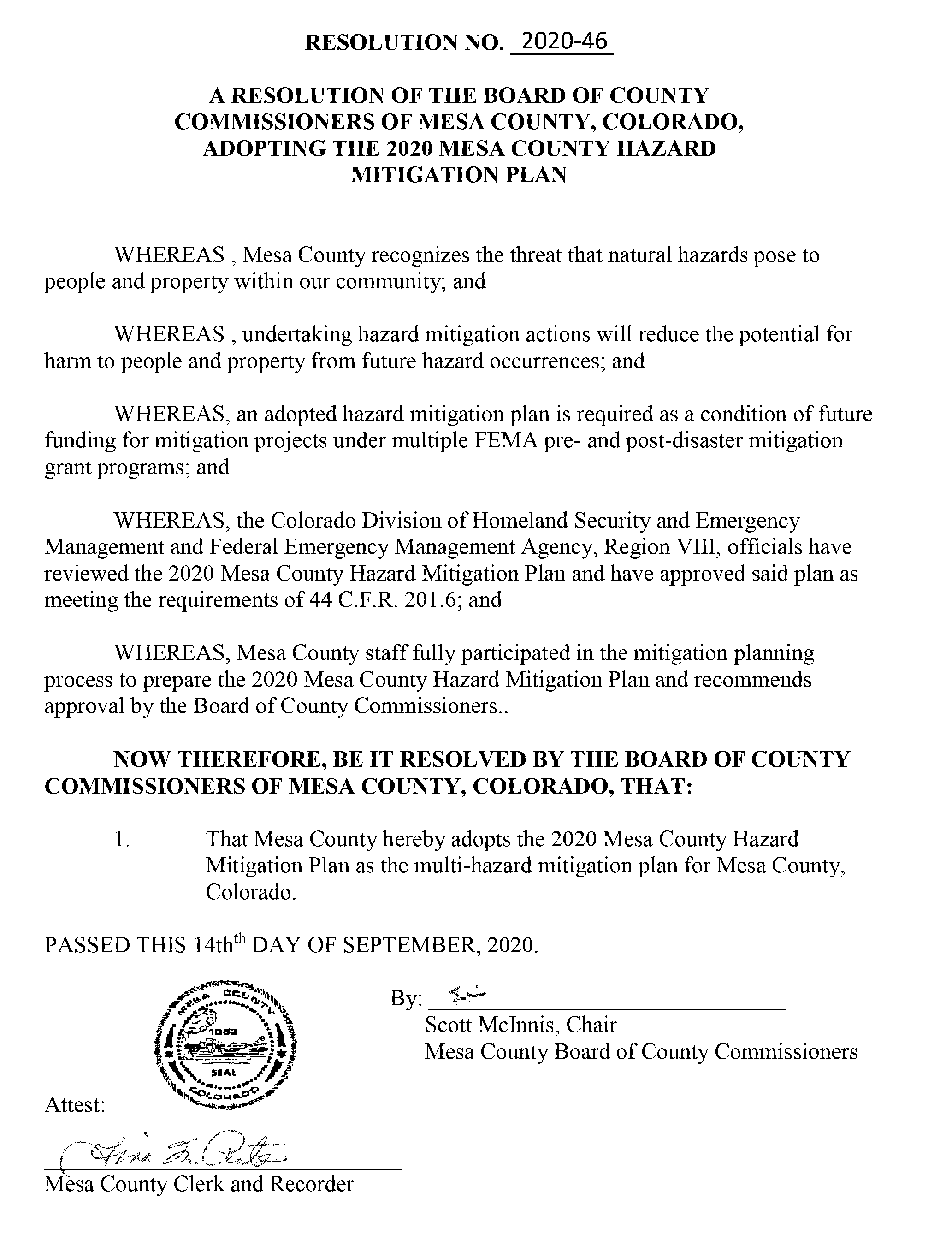
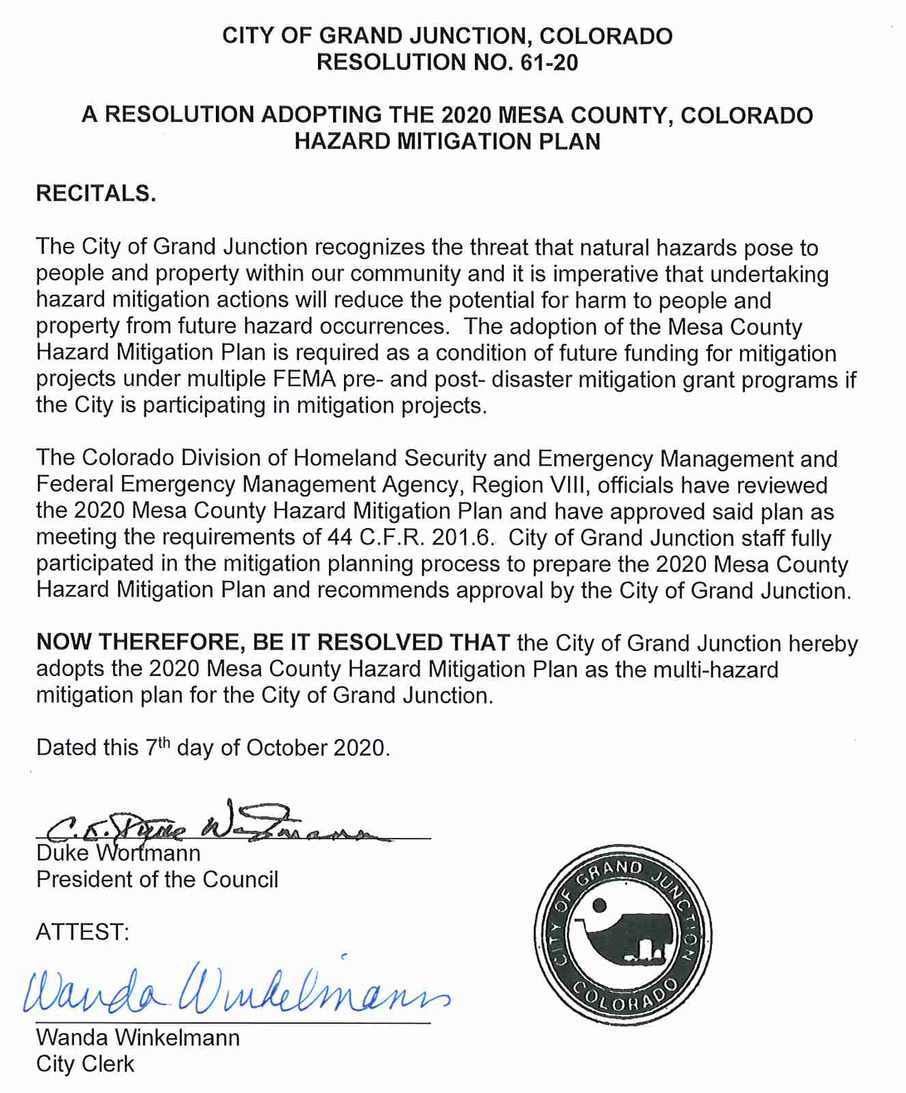
(Res. 61-20, 10-7-20; Res. 32-15, 7-1-15; Res. 05-10, 1-6-10)
Appendix B Kick-off Meeting Invitation List
|
Agency |
Address |
City |
State |
Zip |
|---|---|---|---|---|
|
Town of Collbran |
PO Box 387 |
Collbran |
CO |
81624 |
|
City of Fruita |
325 E. Aspen Ave. |
Fruita |
CO |
81521 |
|
City of Grand Junction |
250 North 5th St. |
Grand Junction |
CO |
81501 |
|
Town of DeBeque |
PO Box 60 |
DeBeque |
CO |
81630 |
|
Town of Palisade |
PO Box 128 |
Palisade |
CO |
81526 |
|
Central Orchard Mesa Fire Protection District |
3253 B 1/2 Rd |
Grand Junction |
CO |
81503 |
|
DeBeque Fire Protection District |
PO Box 180 |
DeBeque |
CO |
81630 |
|
Glade Park Volunteer Fire Department |
16400 DS Rd |
Glade Park |
CO |
81523 |
|
Grand Junction Rural Fire Protection District |
PO Box 4450 |
Grand Junction |
CO |
81502 |
|
Lower Valley Fire Protection District |
168 N. Mesa St |
Fruita |
CO |
81521 |
|
Palisade Rural Fire Protection District |
PO Box 368 |
Palisade |
CO |
81526 |
|
Gateway-Unaweep Fire Protection District |
PO Box 126 |
Gateway |
CO |
81522 |
|
Clifton Fire Protection District |
3254 F Rd |
Clifton |
CO |
81520 |
|
East Orchard Mesa Fire Protection District |
455 35 Rd |
Palisade |
CO |
81526 |
|
Grand Junction Fire Department |
625 Ute Ave |
Grand Junction |
CO |
81501 |
|
Lands End Fire Protection District |
34980 Pronghorn Dr |
Whitewater |
CO |
81527 |
|
Palisade Fire Department |
341 W 7th St |
Palisade |
CO |
81526 |
|
Plateau Valley Fire Protection District |
49084 KE 1/2 Rd |
Mesa |
CO |
81643 |
|
Grand Mesa Metropolitan District |
PO Box 485 |
Mesa |
CO |
81643 |
|
Southwest Mesa County Rural Services PID |
PO Box 20000 |
Grand Junction |
CO |
81502-5086 |
|
Whitewater PID |
PO Box 20000 |
Grand Junction |
CO |
81502-5095 |
|
Mesa County Lower Valley PID |
PO Box 20000 |
Grand Junction |
CO |
81502-5086 |
|
Mesa County Whitewater Urban Services PID |
PO Box 20000 |
Grand Junction |
CO |
81521-5086 |
|
Grand Valley Drainage District |
722 23 Rd |
Grand Junction |
CO |
81505 |
|
Redlands Mesa Metropolitan District |
450 E. 17th Ave |
Denver |
CO |
80203 |
|
Upper Grand Valley Pest Control District |
PO Box 20000 |
Grand Junction |
CO |
81502-5087 |
|
Mesa Water and Sanitation District |
PO Box 213 |
Mesa |
CO |
81643 |
|
Central Grand Valley Sanitation District |
541 Hoover Dr |
Grand Junction |
CO |
81504 |
|
Persigo Wastewater Treatment Plant/Service Area |
2145 River Rd |
Grand Junction |
CO |
81505 |
|
Clifton Sanitation District |
3217 D Rd |
Clifton |
CO |
81520 |
|
Clifton Water District |
510 34 Rd |
Clifton |
CO |
81520 |
|
Ute Water Conservancy District |
560 25 Rd |
Grand Junction |
CO |
81506 |
|
Colorado River District |
PO Box 1120 |
Glenwood Springs |
CO |
81602 |
|
Colorado Division of Water Resources |
2754 Compass Dr #175 |
Grand Junction |
CO |
81506 |
|
West Divide Water Conservancy District |
PO Box 1478 |
Rifle |
CO |
81650 |
|
Colorado State Patrol |
554 Jurassic Ct |
Fruita |
CO |
81521 |
|
Collbran Town Marshal |
1010 High St |
Collbran |
CO |
81624 |
|
Fruita Police Department |
101 W. McCune Ave |
Fruita |
CO |
81521 |
|
Mesa County Sheriff’s Office |
215 Rice St |
Grand Junction |
CO |
81502 |
|
Grand Junction Police Department |
555 Ute Ave |
Grand Junction |
CO |
81501 |
|
DeBeque Town Marshal |
381 Minter Ave. |
DeBeque |
CO |
81630 |
|
Palisade Police Department |
175 East 3rd St |
Palisade |
CO |
81526 |
|
Federal Bureau of Investigation |
PO Box 1905 |
Grand Junction |
CO |
81502 |
|
National Weather Service – GJT |
2844 Aviators Way |
Grand Junction |
CO |
81506 |
|
Grand Valley Power |
845 22 Rd |
Grand Junction |
CO |
81505 |
|
Bureau of Land Management |
2815 H Rd |
Grand Junction |
CO |
81506 |
|
Mesa County Flood Plain Manager |
PO Box 20000 |
Grand Junction |
CO |
81502 |
|
Xcel Energy |
2538 Blichman Ave |
Grand Junction |
CO |
81505 |
|
Redlands Water and Power Co. |
2216 S. Broadway |
Grand Junction |
CO |
81503 |
|
Bureau of Land Management |
2774 Landing View Ln |
Grand Junction |
CO |
81506 |
|
Colorado State Forest Service |
3170 B 1/2 Rd |
Grand Junction |
CO |
81503 |
|
CDHSEM |
9195 E. Mineral Ave., Suite 200 |
Centennial |
CO |
80112 |
|
Colorado Dept. of Agriculture |
700 Kipling St., Suite 4000 |
Lakewood |
CO |
81215-8000 |
|
Grand Junction Regional Communications Center |
555 Ute Ave |
Grand Junction |
CO |
81501 |
|
Grand Junction Public Works |
250 North 5th St. |
Grand Junction |
CO |
81501 |
|
Mesa County GIS |
544 Rood Ave |
Grand Junction |
CO |
81501 |
|
Mesa County Engineering Department |
PO Box 20000 |
Grand Junction |
CO |
81502 |
|
Mesa County Planning Department |
PO Box 20000 |
Grand Junction |
CO |
81502 |
|
Mesa County Public Works |
PO Box 20000 |
Grand Junction |
CO |
81502 |
|
Mesa County Health Department |
510 29 1/2 Rd |
Grand Junction |
CO |
81504 |
|
Colorado Water Conservation Board |
1313 Sherman St., Room 721 |
Denver |
CO |
80203 |
|
Colorado Geological Survey |
1500 Illinois St |
Golden |
CO |
80401 |
|
Colorado National Monument |
1750 Rim Rock Dr |
Fruita |
CO |
81521 |
|
FEMA Region VIII – Mitigation Office |
PO Box 25267 |
Denver |
CO |
80225-0267 |
|
U.S. Forest Service |
2777 Crossroads Blvd |
Grand Junction |
CO |
81506 |
|
U.S. Forest Service |
2250 Highway 50 |
Delta |
CO |
81416 |
|
Mesa County Fleet Services |
PO Box 20000 |
Grand Junction |
CO |
81502-5001 |
|
City of Grand Junction Water Department |
333 West Ave. Bldg A |
Grand Junction |
CO |
81501 |
|
5-2-1 Drainage Authority |
250 North 5th St. |
Grand Junction |
CO |
81501 |
|
Bureau of Reclamation |
445 W. Gunnison Ave |
Grand Junction |
CO |
81501 |
|
Grand Valley Fire Protection District |
124 Stone Quarry Rd |
Parachute |
CO |
81635 |
|
Garfield County Emergency Management |
107 8th St |
Glenwood Springs |
CO |
81601 |
|
Delta County Emergency Management |
555 Palmer St. |
Delta |
CO |
81416 |
(Res. 61-20, 10-7-20; Res. 32-15, 7-1-15; Res. 05-10, 1-6-10)
Appendix C Invitation Letter to Kick-off Meeting
August 19, 2019
To Whom It May Concern:
Mesa County Emergency Management will be undertaking the task of updating the 2015 Mesa County Hazard Mitigation Plan. This multijurisdictional plan is developed to assess risk from natural hazards and to identify actions that can be taken in advance to reduce long-term risk to the people and property of Mesa County. The Disaster Mitigation Act of 2000 requires all local governments to have an approved plan to be eligible for certain federal disaster assistance and mitigation funding programs.
The hazard mitigation planning process is heavily dependent on the participation of representatives from local government agencies and departments, the public, and other stakeholder groups. A Hazard Mitigation Planning Committee will be formed to support this project and will include representatives from the County, cities/towns, special districts, and other local, state, and federal agencies in or that serve Mesa County.
Your organization’s participation on the planning committee is requested due to the information, technical knowledge or other valuable experience you have about your community or agency. Please designate a representative to serve on the committee and attend the kickoff meeting. If you have more than one department or individuals that you would like to attend, please feel free to invite them.
Mesa County Hazard Mitigation Plan Kick-off Meeting
September 3, 2019 (10:00 AM – 12:00 PM)
Mesa County Central Services Building – Room 40A
200 South Spruce St., Grand Junction, CO 81501
Sincerely,
Andrew Martsolf, MBA
Mesa County Emergency Manager
(Res. 61-20, 10-7-20; Res. 32-15, 7-1-15; Res. 05-10, 1-6-10)
Appendix D HMPC Meeting Agendas, Sign-In Sheets, and Sample Worksheets
|
AGENDA |
|
|---|---|
|
Mesa County Multi-Hazard Mitigation Plan Kick-off Meeting |
|
|
September 3, 2019 |
|
|
10:00 a.m. – 12:00 p.m. |
|
|
Mesa County Courthouse: Mesa County Services Building |
|
|
10:00 a.m. – 10:15 a.m. |
Opening Remarks |
|
|
Introductions |
|
10:15 a.m. – 10:30 a.m. |
Local Hazard Mitigation Plan Purpose and Requirements |
|
10:30 a.m. – 10:45 a.m. |
Identification of Multi-Jurisdictional Participation and Hazard Mitigation Planning Committee |
|
|
Planning for Public Involvement |
|
10:45 a.m. – 12:00 p.m. |
Hazard Identification and Data Collection Needs |
|
|
Worksheets 1 – 3 |
|
|
Next Steps |
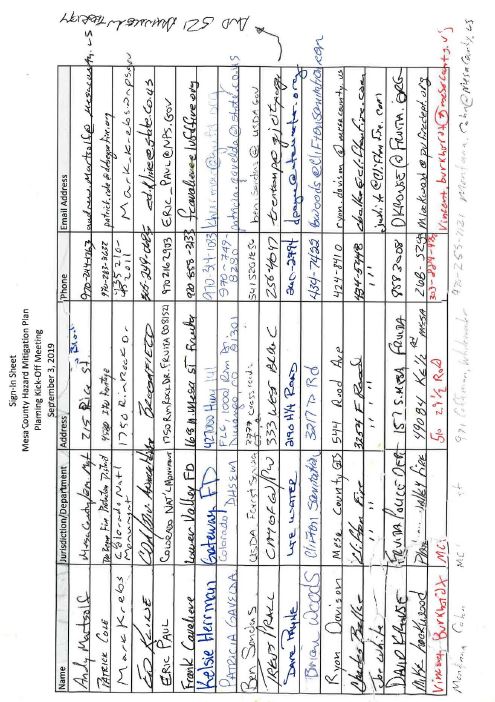
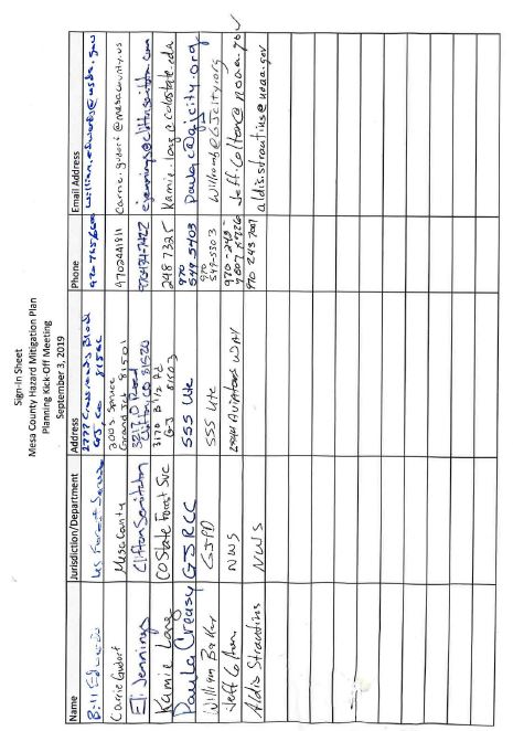
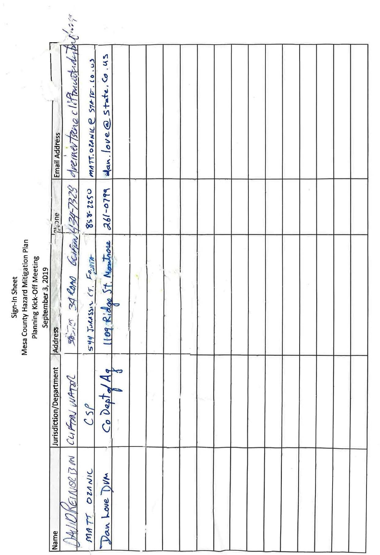
|
AGENDA |
|
|---|---|
|
Mesa County Multi-Hazard Mitigation Plan – 2nd Meeting |
|
|
October 9, 2019 |
|
|
10:00 a.m. – 12:00 p.m. |
|
|
Mesa County Courthouse: Mesa County Central Services Building |
|
|
10:00 a.m. – 10:15 a.m. |
Opening Remarks |
|
|
Introductions |
|
10:15 a.m. – 10:45 a.m. |
Review Hazard Scoring Model and Validate Mesa County and Jurisdiction Hazard Profiles |
|
|
Validate Plan Focus (High Hazards) |
|
|
Validate Plan Goals |
|
10:45 a.m. – 11:30 a.m. |
Review and validate hazard areas for the purpose of conducting vulnerability assessments |
|
11:30 a.m. – 12:00 p.m. |
Homework Discussion |
|
|
Worksheet 5 Mitigation Project Description (Required for each jurisdiction) |
|
|
Next Steps |
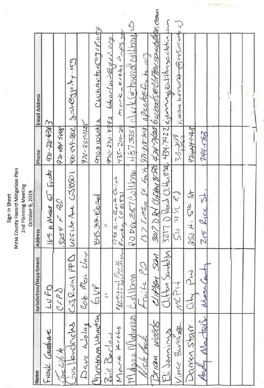
|
AGENDA |
|
|---|---|
|
Mesa County Multi-Hazard Mitigation Plan – 3rd Meeting |
|
|
November 13, 2019 |
|
|
10:00 a.m. – 12:00 p.m. |
|
|
Mesa County Central Services Building |
|
|
10:00 a.m. – 10:15 a.m. |
Opening Remarks |
|
|
Introductions |
|
10:15 a.m. – 10:45 a.m. |
Review Community Asset Inventory |
|
|
Review Hazard Mitigation Action Matrix for Project Status |
|
|
Prioritization of mitigation actions |
|
11:00 a.m. – 11:30 a.m. |
Next Steps |
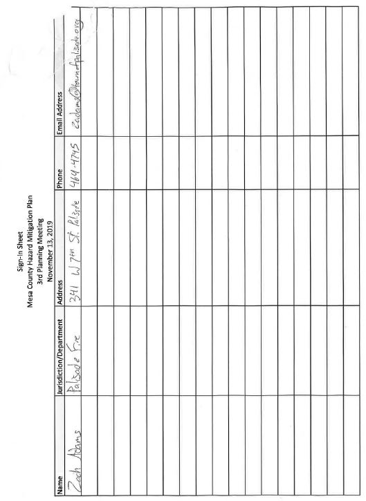
|
AGENDA |
|
|---|---|
|
Mesa County Multi-Hazard Mitigation Meeting – Final Planning Meeting |
|
|
January 8, 2020 |
|
|
9:00 a.m. – 10:00 a.m. |
|
|
Mesa County Courthouse: Mesa County Centralized Services Building |
|
|
9:00 a.m. – 9:15 a.m. |
Opening Remarks |
|
|
Introductions |
|
9:15 a.m. – 10:00 a.m. |
Review of Updated Plan Elements |
|
|
Remaining Planning Gaps |
|
|
Next Steps |
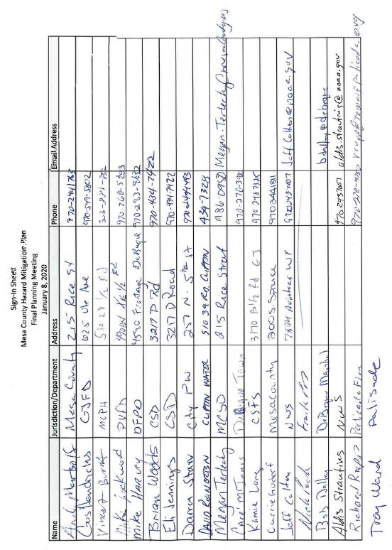
(Res. 61-20, 10-7-20; Res. 32-15, 7-1-15; Res. 05-10, 1-6-10)
Appendix E Data Collection Worksheets
|
Instructions: Please fill out one sheet for each event with as much detail as possible. Attach supporting documentation, photocopies of newspaper articles or other original sources. |
|
|
Type of natural hazard event: |
|
|
Date of event: |
|
|
Description of the nature and magnitude of the event: |
|
|
Location (community or description with map): |
|
|
Injuries: |
|
|
Deaths: |
|
|
Property damage: |
|
|
Infrastructure damage: |
|
|
Business/Economic impact: |
|
|
Road/School/Other closures: |
|
|
Other damage: |
|
|
Total damages: |
|
|
Insured losses: |
|
|
Fed/State Disaster relief funding ($): |
|
|
Opinion on likelihood of occurring again: |
|
|
Source of information: |
|
|
Comments: |
|
|
Contact Information |
|
|
Name of Jurisdiction: |
|
|
Submitted By: |
|
|
Address: |
|
|
Phone: |
|
|
Instructions: Please complete to the extent possible the vulnerable buildings, populations, critical facilities and infrastructure for each hazard that affects your jurisdiction. This information will be used to estimate disaster losses, which can then be used to gauge potential benefits of mitigation measures. Attach supporting documentation, photocopies of engineering reports or other sources. |
||
|---|---|---|
|
|
|
|
|
Hazard: |
||
|
|
|
|
|
Location and Description of Potential Impact: |
||
|
|
|
|
|
Building Inventory: |
||
|
|
|
|
|
Residential |
Count |
Estimated Value |
|
|
|
|
|
Comments |
||
|
Commercial |
Count |
Estimated Value |
|
|
|
|
|
Comments |
||
|
|
||
|
Industrial |
Count |
Estimated Value |
|
|
|
|
|
Comments |
||
|
Agricultural |
Count |
Estimated Value |
|
|
|
|
|
Comments |
||
|
|
||
|
Other (Define, e.g., gov.) |
Count |
Estimated Value |
|
|
|
|
|
Comments |
||
|
Local Mitigation Capabilities Tracker for Local and State Plan Updates |
||||
|---|---|---|---|---|
|
|
||||
|
Planning and Regulatory |
Yes/No |
|
Administrative and Technical |
Yes/No |
|
Building Codes |
Yes |
Emergency Manager |
Yes |
|
|
Building Codes Year |
Yes |
Floodplain Administrator |
Yes |
|
|
BCEGS Rating |
No |
Community Planning: |
|
|
|
Capital Improvements Program (CIP) or Plan |
No |
– Planner/Engineer (Land Devel) |
Yes |
|
|
Community Rating System (CRS) |
Yes |
– Planner/Engineer/Scientist (Natural Hazards) |
Yes |
|
|
Community Wildfire Protection Plan (CWPP) |
Yes |
– Engineer/Professional (Construction) |
No |
|
|
Comprehensive, Master, or General Plan |
Yes |
– Resiliency Planner |
No |
|
|
Economic Development Plan |
No |
– Transportation Planner |
No |
|
|
Elevation Certificates |
No |
Building Official |
Yes |
|
|
Erosion/Sediment Control Program |
No |
GIS Specialist and Capability |
Partial |
|
|
Floodplain Management Plan or Ordinance |
Yes |
Grant Manager, Writer, or Specialist |
Yes |
|
|
Flood Insurance Study |
Yes |
Warning Systems/Services: |
|
|
|
Growth Management Ordinance |
No |
– General |
Yes |
|
|
Non-Flood Hazard-Specific Ordinance or Plan (e.g., Steep Slope, Wildfire, Snow Load) |
No |
– Flood |
Yes |
|
|
NFIP |
Yes |
– Wildfire |
Yes |
|
|
Site Plan Review Requirements |
Yes |
– Tornado |
No |
|
|
Stormwater Program, Plan, or Ordinance |
No |
– Geological Hazards |
No |
|
|
Zoning Ordinance |
Yes |
Other |
|
|
|
Financial |
Yes/No |
Education and Outreach |
Yes/No |
|
|
Has community used any of the following to fund mitigation activities: |
|
Local Citizen Groups That Communicate Hazard Risks |
No |
|
|
– Levy for Specific Purposes with Voter Approval |
No |
Firewise |
No |
|
|
– Utilities Fees |
No |
StormReady |
No |
|
|
– System Development/Impact Development Fee |
No |
Other |
|
|
|
– General Obligation Bonds to Incur Debt |
Yes |
|
|
|
|
– Special Tax Bonds to Incur Debt |
No |
|
|
|
|
– Withheld Spending in Hazard-Prone Areas |
No |
|
|
|
|
– Stormwater Service Fees |
No |
|
|
|
|
– Capital Improvement Project Funding |
Yes |
|
|
|
|
– Community Development Block Grants |
No |
|
|
|
|
– Other |
|
|
|
|
|
Instructions: For each type of loss identified on previous worksheets, determine possible actions. Record information below. |
||||
|
|
|
|
|
|
|
Hazard: |
|
|
|
|
|
|
|
|
|
|
|
Priority |
Possible Actions (Include Location) |
Sources of Information (include sources you reference and documentation) |
Comments (Note any initial issues you may want to discuss or research further) |
Planning Reference (Determine into which pre-existing planning suggested projects can be integrated) |
|
|
|
|
|
|
|
|
|
|
|
|
|
|
|
|
|
|
|
|
|
|
|
|
|
|
|
|
|
|
|
|
|
|
|
|
|
|
||||
|
Contact Information: |
||||
|
Name of Jurisdiction: |
||||
|
Submitted By: |
||||
|
Address: |
||||
|
Phone: |
||||
|
Instructions: Use this guide to record potential mitigation projects (one or more pages per project) identified during the planning process. Provide as much detail as possible and use additional pages as necessary. These will be collected following HMPC meetings on mitigation goals and measures and included in the plan. |
|
Jurisdiction: |
|
Mitigation Project: |
|
Issue/Background: |
|
Other alternatives: |
|
Responsible Agency: |
|
Priority (High-Medium-Low): |
|
Cost Estimate: |
|
Benefits (Avoided Losses): |
|
Potential Funding: |
|
Schedule: |
|
Worksheet Submitted By: |
|
Name and Title: |
|
Phone: |
|
Address: |
(Res. 61-20, 10-7-20; Res. 32-15, 7-1-15; Res. 05-10, 1-6-10)
Appendix F Mesa County Hazard Mitigation Planning Committee Members
|
Bill Barlow |
Grand Valley Power |
|
Christmas Wharton |
Grand Valley Power |
|
Brian Woods |
Clifton Sanitation |
|
Eli Jennings |
Clifton Sanitation |
|
Carrie Gudorf |
Mesa County (Engineering) |
|
Gus Hendricks |
Grand Junction Rural Fire Protection District (Fire Department) |
|
David Reinertsen |
Clifton Water |
|
Paula Creasy |
Grand Junction Regional Communications Center |
|
William Baker |
City of Grand Junction (Police Department) |
|
Trent Prall |
City of Grand Junction |
|
Richard Rupp |
Town of Palisade (Fire Department) |
|
Dave Krause |
City of Fruita (Police Department) |
|
Dave Payne |
Ute Water District |
|
Kamie Long |
Colorado State Forest Service |
|
Mike Harvey |
DeBeque Fire Protection District |
|
Aldis Strautins |
National Weather Service |
|
Vincent Burkhardt |
Mesa County (Public Health) |
|
Matt Ozanic |
Colorado State Patrol |
|
Jeff Colton |
National Weather Service |
|
Andy Martsolf |
Mesa County Office of Emergency Management |
|
Chris Kadel |
Mesa County (GIS) |
|
Bob Dalley |
Town of DeBeque (Town Marshal) |
|
Frank Cavaliere |
Lower Valley Fire Protection District |
|
Ryan Davison |
Mesa County (GIS) |
|
Mike Lockwood |
Plateau Valley Fire Protection District |
|
Patrick Cole |
DeBeque Fire Protection District |
|
Mark Krebs |
Colorado National Monument |
|
Eric Paul |
Colorado National Monument |
|
Patricia Gavelda |
Colorado Division of Homeland Security and Emergency Management |
|
Charles Balke |
Clifton Fire Protection District |
|
Joe White |
Clifton Fire Protection District |
|
Care’ McInnis |
Town of DeBeque |
|
Montana Cohn |
Mesa County Weed and Pest |
|
Bill Edwards |
US Forest Service |
|
Dan Love |
Colorado Department of Agriculture |
|
Ed Kline |
Colorado Department of Agriculture |
|
Dave Wolny |
Colorado Mesa University |
|
Nick Peck |
Fruita Police Department |
|
Darren Starr |
City of Grand Junction |
|
Janet Hawkinson |
Town of Palisade |
|
Troy Ward |
Town of Palisade |
|
Melonie Matarozzo |
Town of Collbran |
(Res. 61-20, 10-7-20; Res. 32-15, 7-1-15; Senate Bill 11-265, 6-6-11; Res. 05-10, 1-6-10)
Appendix G Public Review and Comment Notice

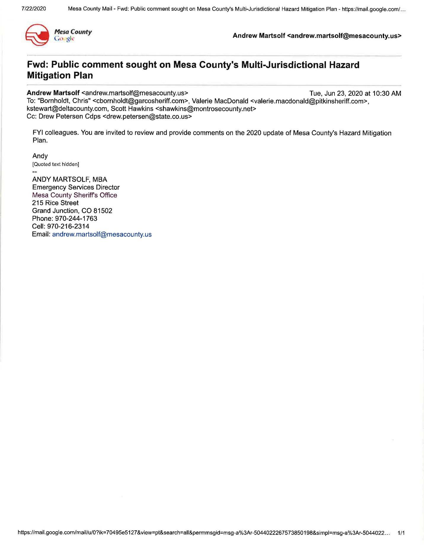
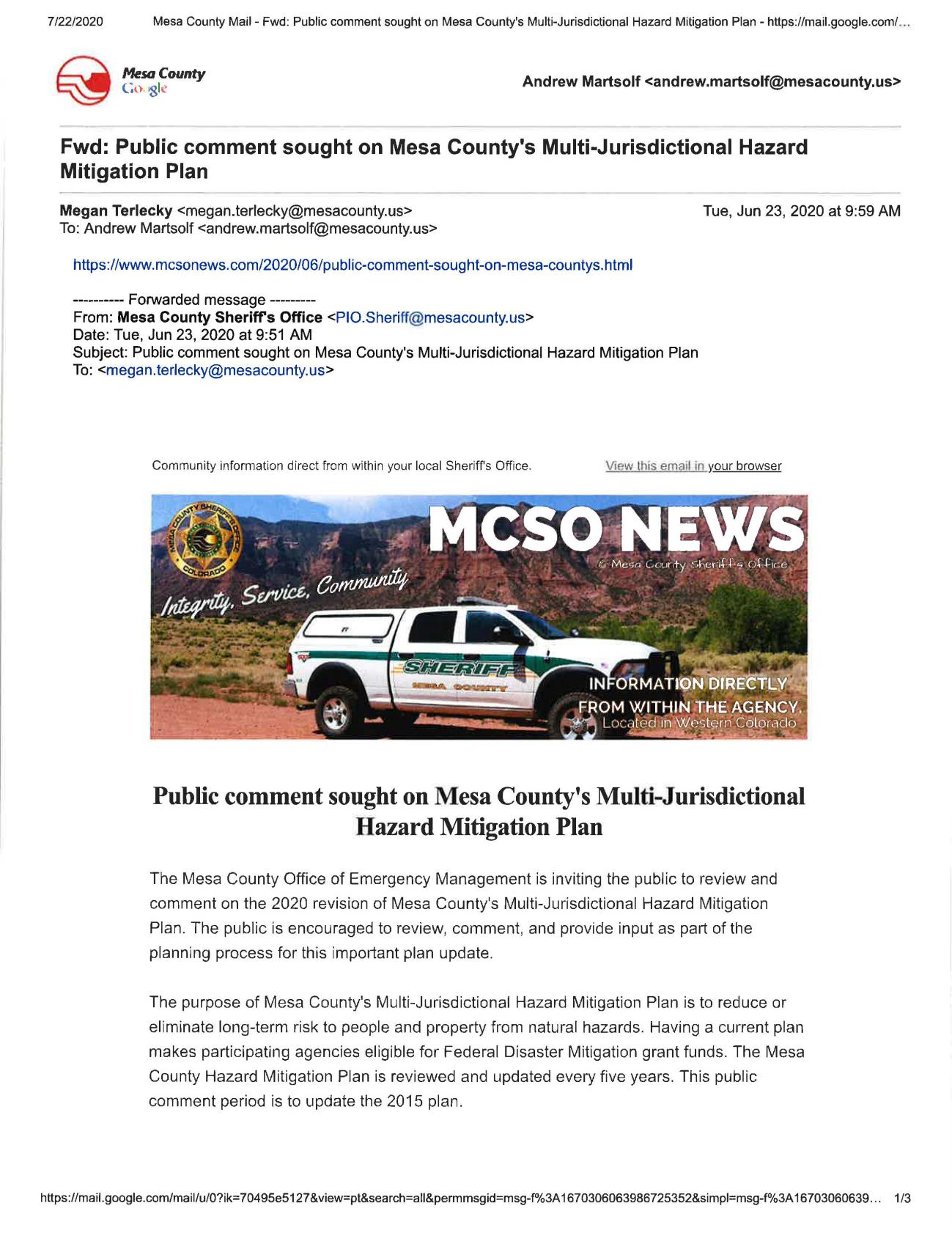
(Res. 61-20, 10-7-20; Res. 32-15, 7-1-15; Res. 05-10, 1-6-10)
Appendix H Public Hazard Perception Survey Results.
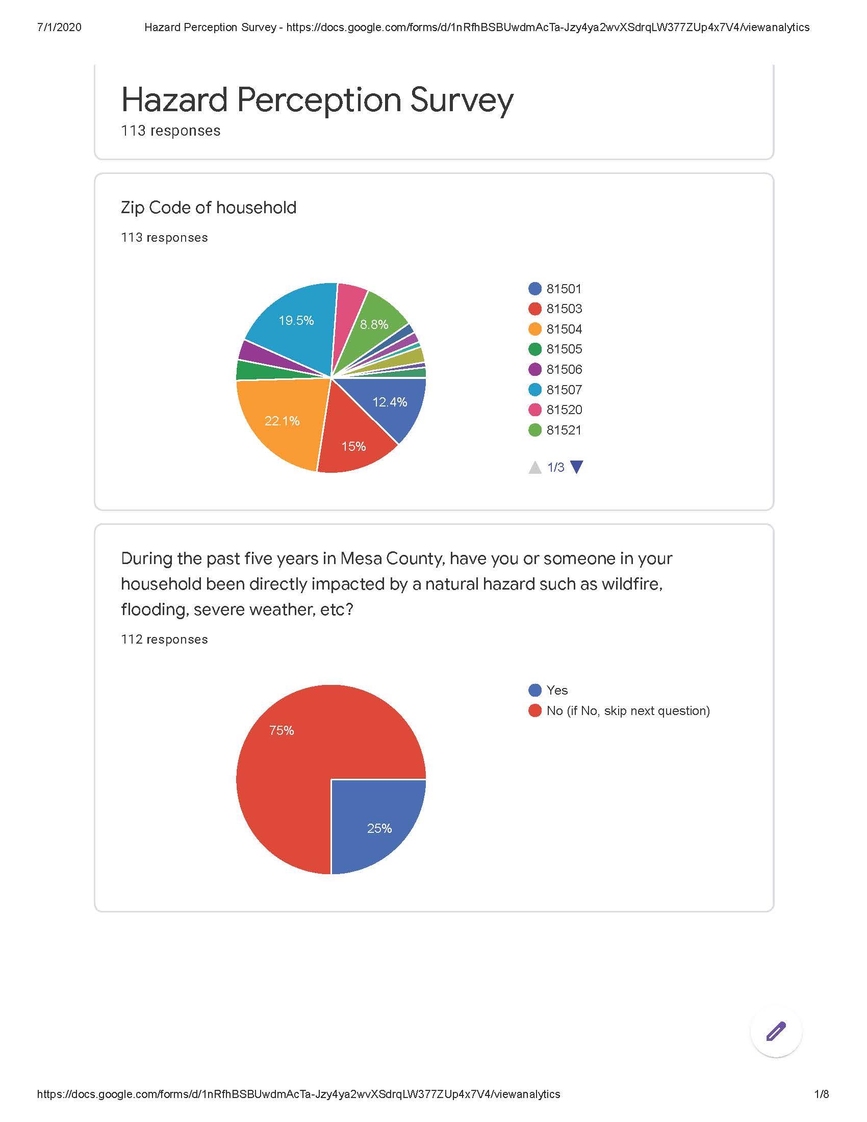
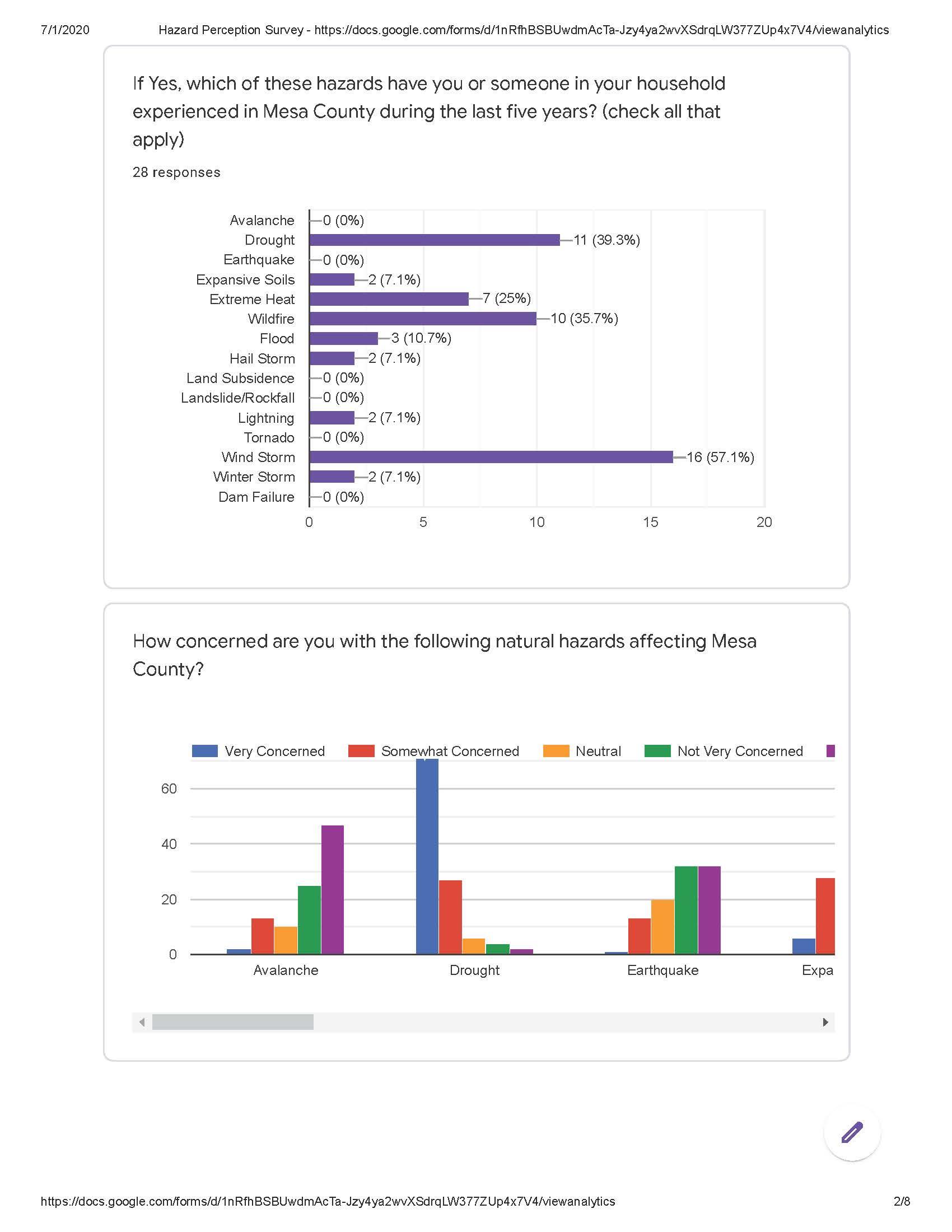

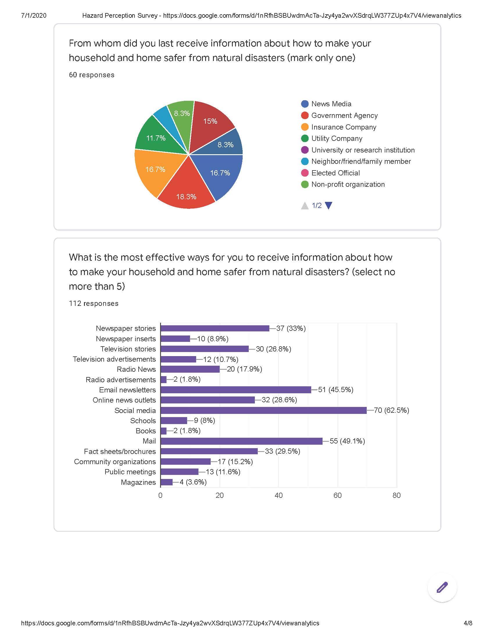
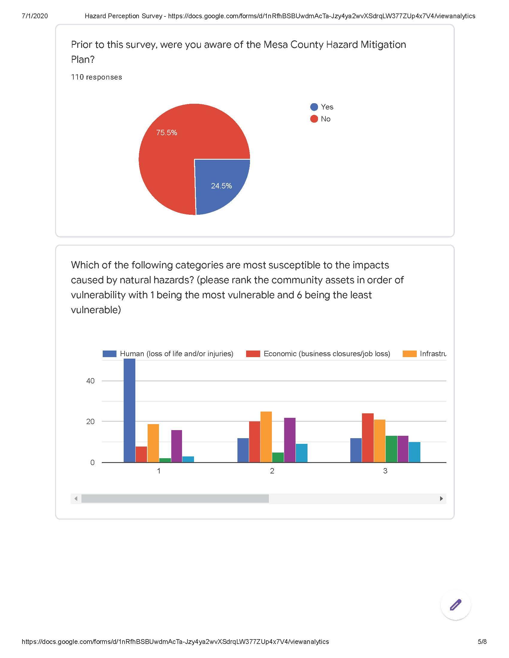
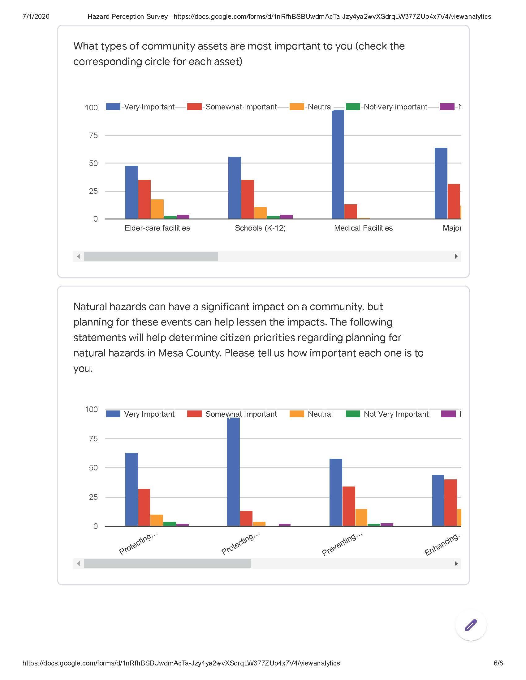
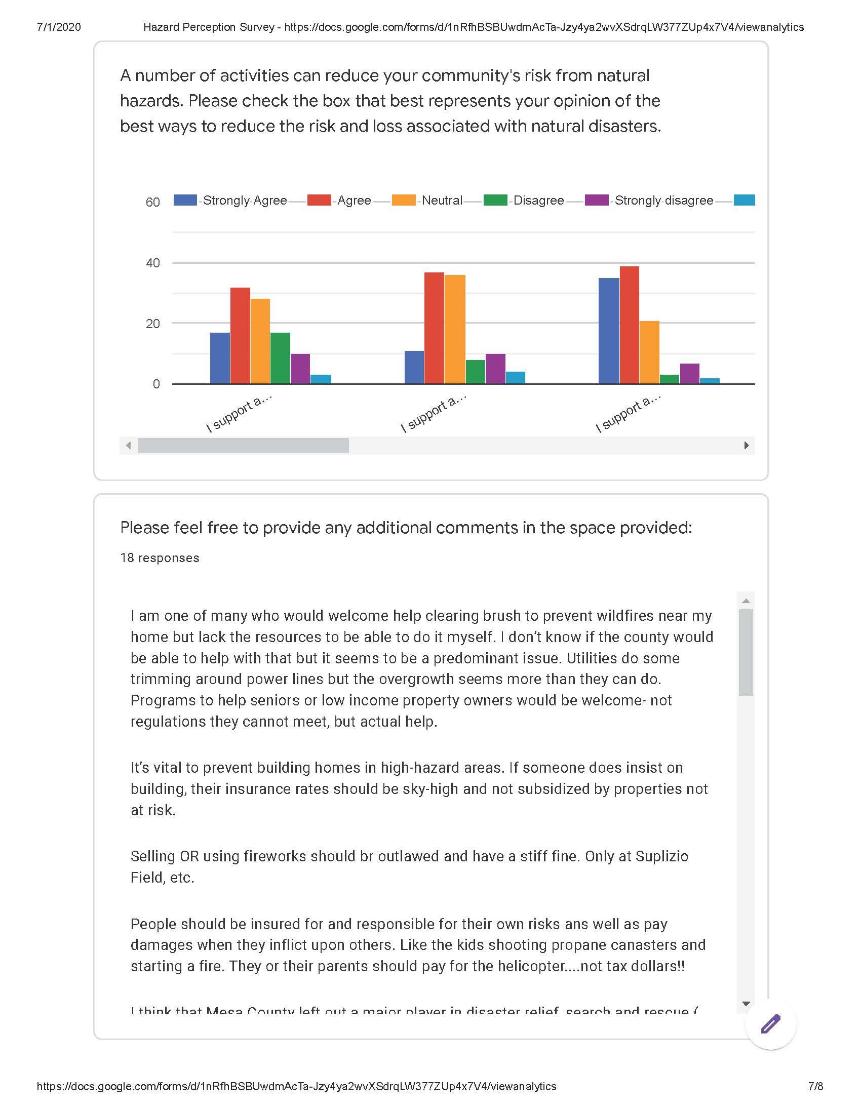
(Res. 61-20, 10-7-20)
Appendix I Table of Figures
|
Figure 1 |
Hazard Mitigation Planning Area |
|
Figure 2 |
Estimated County Population |
|
Figure 3 |
Jurisdiction Population |
|
Figure 4 |
Age Distribution in Mesa County |
|
Figure 5 |
Mesa County Labor Force and Unemployment |
|
Figure 6 |
Map of Dams in Mesa County |
|
Figure 7 |
Faults in Mesa County |
|
Figure 8 |
Rivers and Tributaries |
|
Figure 9 |
Mesa County Landslide Map |
|
Figure 10 |
DeBeque Canyon Slide Area |
|
Figure 11 |
Photo of DeBeque Canyon Slide Area – Interstate 70 |
|
Figure 12 |
Photo of DeBeque Canyon Slide Area – Interstate 70 |
|
Figure 13 |
Rockfall West of Palisade Along Interstate 70 |
|
Figure 14 |
Rockfall Event in DeBeque Canyon at Beaver Tail Tunnel on Interstate 70 |
|
Figure 15 |
Rockfall Event in DeBeque Canyon At Beaver Tail Tunnel on Interstate 70 |
|
Figure 16 |
West Salt Creek Landslide Viewed From the East Flank of the Head Escarpment |
|
Figure 17 |
West Salt Creek Landslide Change in Topography |
|
Figure 18 |
Mesa County Wildfire Risk Assessment |
|
Figure 19 |
Mesa County Wetlands Areas |
|
Figure 20 |
Mesa County Habitats for Threatened and Endangered Species |
|
Figure 21 |
Potential Conservation Areas |
|
Figure 22 |
Mesa County Ecologically Sensitive Areas |
|
Figure 23 |
HAZUS Earthquake Scenario |
|
Figure 24 |
Bridgeport Earthquake Ground Motion |
|
Figure 25 |
Bridgeport Earthquake Scenario, Displaced Homes |
|
Figure 26 |
Town of Collbran |
|
Figure 27 |
Town of Palisade |
|
Figure 28 |
City of Grand Junction |
|
Figure 29 |
City of Fruita |
|
Figure 30 |
Town of Debeque |
|
Figure 31 |
Fire Protection Districts in Mesa County |
|
Figure 32 |
Plateau Valley FPD Boundary |
|
Figure 33 |
Lower Valley Fire Protection District |
|
Figure 34 |
Grand Junction Fire Department and Grand Junction Rural Fire Protection District |
|
Figure 35 |
DeBeque Fire Protection District |
|
Figure 36 |
Clifton Fire Protection District |
(Res. 61-20, 10-7-20; Res. 32-15, 7-1-15; Res. 05-10, 1-6-10)