


Chapter 13.25
PIGEON CREEK WATERSHED COMMISSION
Sections:
13.25.010 Creation of Watershed Commission.
13.25.010 Creation of Watershed Commission.
(1) The designated watershed within which the proposed Pigeon Creek Watershed Development Commission would exercise its powers is defined by:
(A) the surface water outlet Pigeon Creek, which starts in Gibson County, flows generally south through Gibson and Warrick Counties before heading generally west through Warrick and Vanderburgh Counties. Pigeon Creek joins the Ohio River in Evansville. Pigeon Creek is clearly labeled in the attached map identified as “Exhibit A;” and
(B) the geographic boundaries of the area drained by Pigeon Creek are defined by the combination of three HUC-10 watersheds – Headwaters Pigeon Creek, Big Creek-Pigeon Creek, and Pigeon Creek – totaling approximately 235,000 acres, as shown in the attached map identified as “Exhibit A.”
(2) The area of the county that is inside the geographic boundaries of the designated watershed, as identified under subdivision (1)(B) is on the attached map identified as “Vand_HUC8_Parcels” consisting of 96,025.56 acres or approximately 14.5% of the Highland-Pigeon Watershed.
(3) The flood damage reduction, drainage, storm water management, or water infrastructure purposes for which the proposed commission would be established are detailed in the attached studies, and include channel modifications to increase channel stability and reduce ongoing maintenance needs; channel maintenance and wood management to decrease debris buildup, thereby decreasing localized flooding and improving safety for recreators; and support of agricultural, residential, and municipal stormwater best management practices to reduce the inputs of flow and sediment to Pigeon Creek.
(4) The flood damage reduction, drainage, storm water management, or water infrastructure needs of Vanderburgh County that would be addressed through the county’s membership in the proposed commission include flood reduction through flood storage facilities, flood damage reduction, improved stormwater infrastructure, removal of logjams, decreased stormwater flows, and increased recreational opportunities.
Exhibit A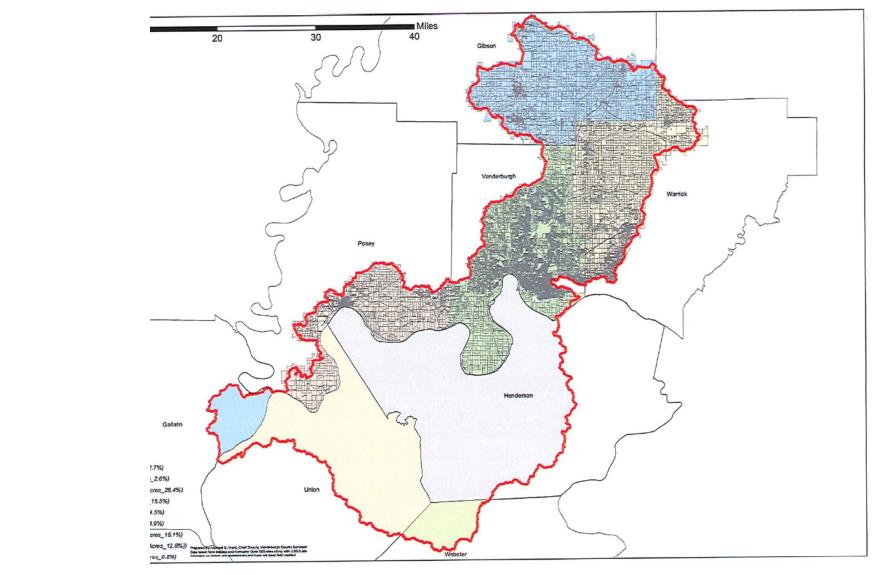
(Ord. 12-23-029 § 1, 12/19/2023)