


Chapter 17.58
A-H AIRPORT HAZARD COMBINING DISTRICT
Sections:
17.58.030 Airport height restriction zones.
17.58.040 Airport zone height limitations.
17.58.050 Airport hazard combining districts established.
17.58.060 Airport hazard combining district map.
17.58.070 Airport hazard combining district boundaries.
17.58.080 Use of land and buildings.
17.58.090 Additional land use regulations.
17.58.160 Conflicting regulations.
Prior ordinance history: Ord. 1-5-87A § 27.
17.58.010 Purpose.
The purpose of the A-H airport hazard combining district is to provide guidelines for future development by regulating and restricting the height of structures and objects of natural growth, and otherwise regulating the use of property in the vicinity of the Winnemucca Municipal Airport by creating the appropriate zones and establishing the boundaries thereof; providing for changes in the restrictions and boundaries of such zones; defining certain terms used herein, referring to the Winnemucca Municipal Airport FAR Part 77 Airspace, and off-airport land use drawings, which are incorporated in and made a part of this chapter; for providing for enforcement; and imposing penalties.
A. It is hereby found that an obstruction has the potential for endangering the lives and property of users of the Winnemucca Municipal Airport and property or occupants of land in its vicinity; that an obstruction may affect existing and future instrument approach minimums at the Winnemucca Municipal Airport; and that an obstruction may reduce the size of areas available for the landing, takeoff, and maneuvering of aircraft, thus tending to destroy or impair the utility of the Winnemucca Municipal Airport and the public investment therein. Accordingly, it is declared:
1. That the creation or establishment of an obstruction has the potential of being a public nuisance and may injure the region served by the Winnemucca Municipal Airport;
2. That the encroachment of noise sensitive or otherwise incompatible land uses within certain areas as set forth hereinbelow may endanger the health, safety, and welfare of the owners, occupants, or users of the land;
3. That it is necessary in the interest of the public health, public safety, and general welfare that the creation or establishment of obstructions that are a hazard to air navigation be prevented;
4. That the prevention of these obstructions should be accomplished, to the extent legally possible, by the exercise of police power without compensation;
5. That the Winnemucca Municipal Airport fulfills an essential community purpose; and
6. It is further declared that the prevention of and the creation or establishment of hazards to air navigation, the elimination, removal, alteration or mitigation of hazards to air navigation, or the marking and lighting of construction are public purposes for which a political subdivision may raise and expend public funds and acquire land or interests in land. (Ord. 11-13-06B § 1)
17.58.020 Definitions.
As used in this chapter, unless the context otherwise requires:
“Airport” means Winnemucca Municipal Airport.
“Airport elevation” means the highest point of an airport’s usable landing area measured in feet from mean sea level. This elevation is four thousand three hundred and seven feet MSL (NAVD 88) as of the date of this chapter.
“Approach surface” means a surface longitudinally centered on the extended runway centerline, extending outward and upward from the end of the primary surface and at the same slope as the approach zone height limitation slope set forth in HCC 17.58.040. In plan the perimeter of the approach surface coincides with the perimeter of the approach zone.
Approach, Transitional, Horizontal and Conical Zones. These zones are set forth in HCC 17.58.030.
“Conical surface” means a surface extending outward and upward from the periphery of the horizontal surface at a slope of twenty to one for a horizontal distance of four thousand feet.
“Hazard to air navigation” means an obstruction determined to have a substantial adverse effect on the safe and efficient utilization of the navigable airspace.
Height. For the purpose of determining the height limits in all zones set forth in this chapter and shown on the zoning map, the datum shall mean sea level elevation unless otherwise specified.
“Heliport primary surface” means the primary surface coincides in size and shape with the designated takeoff and landing area of a heliport. This surface is a horizontal plane at the elevation of the established heliport elevation.
“Horizontal surface” means a horizontal plane one hundred and fifty feet above the established airport elevation, the perimeter of which in plan coincides with the perimeter of the horizontal zone.
“Larger than utility runway” means a runway that is constructed for and intended to be used by propeller driven aircraft of greater than twelve thousand five hundred pounds maximum gross weight and jet powered aircraft.
“NAVD 88” means the North American Vertical Datum 1988. All elevations in this chapter are referenced to the 1988 North American Vertical Datum. To convert elevations referenced from the 1929 National Geodetic Vertical Datum (NGVD 29) to the NAVD 88 datum, subtract 3.3 feet from the NGVD 29 elevation.
“Nonconforming use” means any preexisting structure, object of natural growth, or use of and which is inconsistent with the provisions of this chapter or an amendment thereof.
“Nonprecision instrument runway” means a runway having an existing instrument approach procedure utilizing air navigation facilities with only horizontal guidance, or area type navigation equipment, for which a straight-in nonprecision instrument approach procedure has been approved or planned. It also means a runway for which a nonprecision approach system is planned and is so indicated on an approved airport layout plan or any other planning document.
“Obstruction” means any structure, growth, or other object, including a mobile object, which exceeds a limiting height set forth in HCC 17.58.040.
“Person” means an individual, firm, partnership, corporation, company, association, joint stock association, or governmental entity; includes a trustee, a receiver, an assignee, or a similar representative of any of them.
“Precision instrument runway” means a runway having an existing instrument approach procedure utilizing an instrument landing system (ILS), a precision approach radar (PAR) or a global positioning system (GPS). It also means a runway for which a precision approach system is planned and is so indicated on an approved airport layout plan or any other planning document.
“Primary surface” means a surface longitudinally centered on a runway. When the runway has a specially prepared hard surface, the primary surface extends two hundred feet beyond each end of that runway; for military runways or when the runway has no specially prepared hard surface, or planned hard surface, the primary surface ends at each end of that runway. The width of the primary surface is set forth in HCC 17.58.030. The elevation of any point on the primary surface is the same as the elevation of the nearest point on the runway centerline.
“Runway” means a defined area in an airport prepared for landing and takeoff of aircraft along its length.
“Structure” means an object, including mobile object, constructed or installed by man, including but without limitation buildings, towers, cranes, smokestacks, earth formation, and overhead transmission lines.
Transitional Surfaces. These surfaces extend outward at ninety degree angles to the runway centerline and the runway centerline extended at a slope of seven feet horizontally for each foot vertically from the sides of the primary and approach surfaces to where they intersect the horizontal and conical surfaces. Transitional surfaces for those portions of the precision approach surfaces, which project through and beyond the limits of the conical surface, extend a distance of five thousand feet measured horizontally from the edge of the approach surface and at ninety degree angles to the extended runway centerline.
“Tree” means any object of natural growth.
“Utility runway” means a runway that is constructed for and intended to be used by propeller driven aircraft of twelve thousand five hundred pounds maximum gross weight and less.
“Visual runway” means a runway intended solely for the operation of aircraft using visual approach procedures. (Ord. 11-13-06B § 1)
17.58.030 Airport height restriction zones.
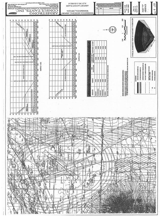
A. In order to carry out the provisions of this chapter, there are hereby created and established certain zones which include all of the land lying beneath the approach surfaces, transitional surfaces, horizontal surfaces, and conical surfaces as they apply to the Winnemucca Municipal Airport. Such zones are shown on the Winnemucca Municipal Airport FAR Part 77 airspace drawing.
1. Three original, official, and identical copies of the FAR Part 77 airspace drawing reflecting the boundaries of the airport hazard combining district map districts of Humboldt County, Nevada, are hereby adopted, and the chairman is hereby authorized to sign and attest each map as the official Winnemucca Municipal Airport hazard combining district map of Humboldt County, Nevada, and such maps shall be filed and maintained as follows:
a. One copy shall be filed for permanent record in the office of the Humboldt County administrator and shall be designated as “Exhibit 1.” This copy shall not be changed in any manner.
b. One copy shall be filed in the planning department office and shall be designated as “Exhibit 2.” This copy shall be maintained by the planning department by posting thereon all subsequent changes and amendments.
c. One copy shall be filed in the office of the city manager/engineer and shall be designated as “Exhibit 3.” This copy shall be maintained by the planning department by posting thereon all subsequent changes and amendments.
B. An area located in more than one of the following zones shall be regulated in accordance with the zone in which each portion of the area is located. The various zones are hereby established and defined as follows:
1. Precision Instrument Runway Approach Zone. The inner edge of this approach zone coincides with the width of the primary surface and is one thousand feet wide. The approach zone expands outward uniformly to a width of sixteen thousand feet at a horizontal distance of fifty thousand feet from the primary surface. Its centerline is the continuation of the centerline of the runway. This is the planned condition for Runway 14/32.
2. Nonprecision Instrument Runway Approach Zone (Larger Than Utility Aircraft). The inner edge of this approach zone is five hundred feet wide. The approach zone expands outward uniformly to a width of three thousand five hundred feet at a horizontal distance of ten thousand feet from the primary surface. Its centerline is the continuation of the centerline of the runway. This is the existing condition for Runway 14/32.
3. Visual Runway Approach Zone (Larger Than Utility Aircraft). The inner edge of this approach zone is five hundred feet wide. The approach surface expands uniformly to a width of one thousand five hundred feet at a horizontal distance of five thousand feet from the primary surface. The centerline of the approach zone is a continuation of the centerline of the runway. This is the existing and planned condition for Runway 02/20.
4. Transitional Zones. The transitional zones are the areas beneath the transitional surfaces.
5. Horizontal Zones. The horizontal zone is established by swinging arcs of ten thousand feet radius from the center of each end of the primary surface of Runway 14/32 and by swinging arcs of five thousand feet radius from the center of each end of the primary surface of Runway 02/20 and connecting the adjacent arcs by drawing lines tangent to those arcs. The horizontal zone does not include the approach and transitional zones.
6. Conical Zone. The conical zone is established as the area that commences at the periphery of the horizontal zone and extends outward therefrom a horizontal distance of four thousand feet. (Ord. 11-13-06B § 1)
17.58.040 Airport zone height limitations.
A. Except as otherwise provided in this chapter, no structure shall be erected, altered, or maintained, and no tree shall be allowed to grow in any zone created by this chapter to a height in excess of the applicable height limit herein established for such zone. Such applicable height limitations are hereby established for each of the zones in question as follows:
1. Precision Instrument Runway Approach Zone. Slopes fifty feet outward for each foot beginning at the end of and at the same elevation as the primary surface and extending to a horizontal distance of ten thousand feet along the extended runway centerline, then slopes forty feet outward for each foot upward beginning at the end of and at the same elevation as the primary surface and extending to a horizontal distance of forty thousand feet along the extended runway centerline. (This is the planned condition for the approach to Runway 32 which is reflected in the airport layout plan, and for which object heights are restricted in accordance with this chapter.)
2. Nonprecision Instrument Runway Approach Zone (Larger Than Utility Aircraft). Slopes thirty-four feet outward for each foot upward beginning at the end of and at the same elevation as the primary surface and extending to a horizontal distance of ten thousand feet along the extended runway centerline. (This is the existing condition for the approach to Runway 14 which is reflected in the airport layout plan, and for which object heights are restricted in accordance with this chapter.)
3. Visual Runway Approach Zone (Larger Than Utility Aircraft). Slopes twenty feet outward for each foot upward beginning at the end of and at the same elevation as the primary surface and extending to a horizontal distance of five thousand feet along the extended runway centerline. This is the existing and planned condition for Runways 2 and 20.
4. Transitional Zone. Slopes seven feet outward for each foot upward beginning at the sides of and at the same elevation as the primary surface and the approach surface, and extending to a height of one hundred fifty feet above the airport elevation. In addition to the foregoing, there are established height limits sloping seven feet outward for each foot upward beginning at the sides of and at the same elevation as the approach surface, and extending to where they intersect the conical surface. Where the precision instrument runway approach zone projects beyond the conical zone, there are established height limits sloping seven feet outward for each foot upward beginning at the sides of and at the same elevation as the approach surface, and extending a horizontal distance of five thousand feet measured at ninety degree angles to the extended runway centerline.
5. Horizontal Zone. Established at one hundred fifty feet above the airport elevation or at a height of four thousand four hundred and fifty seven feet above mean sea level (MSL).
6. Conical Zone. Slopes twenty feet outward for each foot upward beginning at the periphery of the horizontal zone and at one hundred fifty feet above the airport elevation (four thousand four hundred and fifty-seven feet MSL) and extending to a height of three hundred fifty feet (four thousand six hundred and fifty-seven feet MSL) above the airport elevation. (Ord. 11-13-06B § 1)
17.58.050 Airport hazard combining districts established.
A. For the purpose of regulating the development of noise sensitive land uses to promote compatibility between the airport and the surrounding land uses, to protect the airport from incompatible development and to promote the health, safety, and general welfare of property users, the controlled area of Winnemucca Municipal Airport is divided into airport hazard combining districts.
B. The airport hazard combining districts established herein shall be known as:
|
Abbreviated Designation |
Hazard Combining District Name |
|
AIZ |
Airport Influence Zone |
|
TPZ |
Traffic Pattern Zone |
|
AZ |
Approach Zone |
|
IAZ |
Inner Approach Zone |
|
Land Use Category |
Airport Influence Zone (AIZ) |
Traffic Pattern Zone (TPZ) |
Approach Zone (AZ) |
Inner Approach Zone (IAZ) |
|
Residential Single Family, Nursing Homes, Multifamily, Apartments, Condominiums |
C (6) |
C (3, 4) |
C (1, 3) |
X |
|
Transient Lodging, Motels, Hotels |
C (6) |
C (3, 4) |
C (1, 3) |
X |
|
Public Schools, Libraries, Churches |
C (6) |
C (4) |
C (3, 4) |
X |
|
Parking, Cemeteries |
P |
P |
P |
C (5) |
|
Commercial & Industrial Offices, Retail Trade, Service Commercial, Wholesale Trade, Warehouse, Light Industrial, General Manufacturing, Utilities, Extractive industry |
P |
C (6) |
C (4) |
C (1) |
|
Agricultural & Recreational Cropland |
P |
P |
P |
P |
|
Livestock Breeding, Parks, Playgrounds, Zoos, Golf Courses, Riding Stables, Water Recreation |
P |
P |
P |
P |
|
Outdoor Spectator Sports |
P |
C (3) |
C (3, 4) |
X |
|
Amphitheaters |
C (3) |
C (3) |
C (3, 4) |
X |
|
Open Space |
P |
P |
P |
P |
|
P — Permitted |
C — Conditional Use |
X — Not Allowed |
||
|
Conditions: 1. If allowed, avigation easements and disclosure must be required as a condition of development. Limit residential density to 1 unit per 1.25 acres. 2. Any structures associated with uses allowed in the 65 Ldn Noise Contour must be located outside the 65 Ldn Noise Contour. 3. If no reasonable alternative exists, use should be located as far from extended centerline as possible. 4. If allowed, disclosure of airport proximity must be required as a condition of development. An avigation easement should be considered based on proximity to runway centerline. Limit residential density to 1 unit per 125 acres. 5. Transportation facilities in the 65 Ldn Noise Contour (i.e. roads, railroads, waterways) must be configured to comply with FAR Part 77 requirements. 6. Disclosure of airport proximity shall be required as a condition of development. Limit residential density to 1 unit per 1.25 acres. |
Notes:
Development projects which are wildlife attractants, including sewage treatment ponds and new landfills, within 10,000 feet of the runway are unacceptable (FAA Advisory Circular 150/5200-33). New landfills within 6 miles of the airport may require special review (FAA AC 150/5200-34).
An FAA Form 7460-1, “Notice of Proposed Construction or Alteration” must be submitted for any construction or alteration (including hangars and other on-airport and off-airport structures, towers, etc.) within 20,000 horizontal feet of the airport greater in height than an imaginary surface extending outward and upward from the runaway at a slope of 100 to 1 or greater in height than 200 feet above ground.
(Ord. 11-13-06B § 1)
17.58.060 Airport hazard combining district map.
The boundaries of the airport hazard combining districts set out herein are delineated upon the Winnemucca Municipal Airport off-airport land use drawing, said drawing being adopted by reference and made a part of this chapter as fully as if the same were set forth herein in detail.
A. Three original, official, and identical copies of the Winnemucca Municipal Airport off-airport land use drawing reflecting the boundaries of the airport hazard combining districts of Humboldt County, Nevada, are hereby adopted, and the chairman is hereby authorized to sign and attest each map as the official airport hazard combining district map of Humboldt County, Nevada, and such maps shall be filed and maintained as follows:
1. One copy shall be filed for permanent record in the office of the county administrator and shall be designated as “Exhibit 1.” This copy shall not be changed in any manner.
2. One copy shall be filed in the planning department office and shall be designated as “Exhibit 2.” This copy shall be maintained by the planning department by posting thereon all subsequent changes and amendments.
3. One copy shall be filed in the office of the city manager/engineer and shall be designated as “Exhibit 3.” This copy shall be maintained by the planning department by posting thereon all subsequent changes and amendments. (Ord. 11-13-06B § 1)
17.58.070 Airport hazard combining district boundaries.
A. The airport hazard combining district boundary lines shown on the official airport hazard combining district map shall be located and delineated along contour lines established for Winnemucca Municipal Airport. Where uncertainty exists as to the boundaries of the airport hazard combining districts as shown on the official map, the following rules shall apply:
1. Boundaries shall be scaled from the nearest physical feature shown on the map.
2. Boundaries may be scaled from the nearest platted lot line as shown on the map.
3. Distances not specifically indicated on the original airport hazard combining district map shall be determined by a scaled measurement on the map.
4. Where physical features on the ground differ from the information shown on the official airport hazard combining district map or when there arises a question as to how or where a parcel of property is zoned and such questions cannot be resolved by the application of this section, the property shall be considered to be classified as the most restrictive airport hazard combining district.
5. Where a parcel of land lies within more than one airport hazard combining district, the zone within which each portion of the property is located shall apply individually to each portion of the development or property. (Ord. 11-13-06B § 1)
17.58.080 Use of land and buildings.
A. Within the airport hazard combining districts as defined herein, no land shall hereafter be used and no structure or other object shall hereafter be erected, altered, converted, or modified other than for those compatible land uses permitted by underlying zoning districts, as specified in Humboldt County Code. Additional land uses are prohibited in the airport hazard combining districts, regardless of underlying zoning, as set forth in the recommended land use compatibility guideline table.
B. Where any use of prohibited land and buildings set forth in HCC 17.58.070 conflicts with any use of land and buildings set forth in Humboldt County Code as an allowed use, this section shall apply.
C. HCC 17.58.070 does not apply to property within the official boundaries of the airport.
D. Where specified on the recommended airport land use compatibility guidelines table, the property owner shall dedicate, in advance of receiving a building permit, an avigation easement to Humboldt County, Nevada. The purpose of this easement shall be to establish a maximum height restriction on the use of property and to hold the public harmless for any damages caused by noise, vibration, fumes, dust, fuel, fuel particles, or other effects that may be caused by the operation of aircraft landing at, taking off from, or operating on, or at, public airport facilities. (Ord. 11-13-06B § 1)
17.58.090 Additional land use regulations.
A. Within Humboldt County, Nevada, the more restrictive of Humboldt County Code or HCC 17.58.080 shall apply to the development of all property covered by the airport hazard combining district map.
B. When a provision of this section conflicts with any airport height hazard restrictions, the most restrictive provision shall apply.
C. Notwithstanding any other provisions of this chapter or any other chapter of the Humboldt County Code, no use may be made of land, water, or structures within any zone established by this chapter in such a manner as to create electrical interference with navigational signals or radio communication between the airport and aircraft, make it difficult for pilots to distinguish between airport lights and others, or result in glare in the eyes of pilots using the airport; impair visibility in the vicinity of the airport; create bird strike hazards; or otherwise in any way endanger or interfere with the landing, taking off, or flight operations of aircraft utilizing the airport.
D. When a subdivision plat or parcel map is required for any property within an airport hazard combining district or within an area shown on the airport hazard combining district map for the Winnemucca Municipal Airport, the property owner shall dedicate an avigation easement to Humboldt County over and across that property. This easement shall establish a height restriction on the use of the property and hold the public harmless from any damages caused by noise, vibration, fumes, dust, fuel, fuel particles, or other effects that may be caused by the operation of aircraft taking off, landing, or operating on or near Winnemucca Municipal Airport. (Ord. 11-13-06B § 1)
17.58.100 Nonconforming uses.
A. Regulations Not Retroactive. The regulations prescribed by this chapter shall not be construed to require the removal, lowering, or other change or alteration of any structure or tree not conforming to the regulations as of the effective date of this chapter, or otherwise interfere with the continuance of nonconforming use. Nothing contained herein shall require any change in the construction, alteration, or intended use of any structure, the construction or alteration of which was begun prior to the effective date of this chapter, and is diligently prosecuted.
B. Marking and Lighting. Notwithstanding the preceding provision of this section, the owner of any existing nonconforming structure or tree is hereby required to permit the installation, operation, and maintenance thereon of such markers and lights as shall be deemed necessary by Humboldt County or the airport board to indicate to the operators of aircraft in the vicinity of the airport the presence of such airport obstruction. Such markers and lights shall be installed, operated, and maintained at the expense of the Winnemucca Municipal Airport. (Ord. 11-13-06B § 1)
17.58.110 Permits.
A. Future Uses. Except as specifically provided in subsections (A)(1) and (2) of this section, no material change shall be made in the use of land, no structure shall be erected or otherwise established, and no tree shall be planted in any zone hereby created unless a conditional use permit therefor shall have been applied for and granted per Chapter 17.68 HCC. Each application for a conditional use permit shall indicate the purpose for which the permit is desired, with sufficient particularity to permit it to be determined whether the regulating use, structure, or tree would conform to the regulations herein prescribed. An FAA Form 7460-1, Notice of Proposed Construction or Alteration, shall accompany each application. No permit for a use inconsistent with the provisions of this chapter shall be granted unless a variance per Chapter 17.66 HCC has been approved and in accordance with subsection (D) of this section.
1. In the area lying within the limits of the approach zones, transition zones, horizontal zone and conical zone, no permit shall be required by this chapter for any tree or structure less than two hundred feet above ground level which is also lower than an imaginary surface extending outward and upward at a slope of one hundred feet horizontal for each one foot vertical beginning at the closest point of the closest runway.
2. Nothing contained in any of the foregoing exceptions shall be construed as permitting or intending to permit any construction, or alteration of any structure, or growth of any tree in excess of any of the height limits established by this chapter.
B. Existing Uses. No permit shall be granted that would allow the establishment or creation of any obstruction or permit a nonconforming use, structure, or tree to become a greater hazard to air navigation than it was on the effective date of this chapter or any amendments thereto or than it was when the application for a permit was made. Except as indicated, all applications for such a permit shall be granted.
C. Nonconforming Uses Abandoned or Destroyed. Whenever Humboldt County determines that a nonconforming tree or structure has been abandoned or more than eighty percent torn down, physically deteriorated, or decayed, no permit shall be granted that would allow such structure or tree to exceed the applicable height limit or otherwise deviate from the zoning regulations.
D. Variances. Any person desiring to erect or increase the height of any structure, or permit the growth of any tree, or use property not in accordance with the regulations prescribed in this chapter may apply to the planning department for a variance from such regulations per Chapter 17.66 HCC.
1. The application for variance shall be accompanied by a determination from the Federal Aviation Administration as to the effect of a proposal on the operation of air navigation facilities and the safe, efficient use of navigable airspace.
2. Such variances shall be allowed where it is duly found that a literal application or enforcement of the regulations will result in unnecessary hardship and relief granted, will not be contrary to the public interest, will not create a hazard to air navigation, will do substantial justice, and will be in accordance with the spirit of this chapter.
3. Additionally, no application for variance to the requirements of this chapter and Chapter 17.66 HCC may be considered by the county commission unless a copy of the application has been furnished to the airport board for advice as to the aeronautical effects of the variance. If there is no response to the application within fifteen days after receipt, the planning department may act on its own to process said application.
E. Obstruction Marking and Lighting. Any permit or variance granted may, if such action is deemed advisable to effectuate the purpose of this chapter and be reasonable in the circumstances, be so conditioned as to require the owner of the structure or tree in question to install, operate, and maintain, at the owner’s expense, such markings and lights as condition may require in accordance with FAA provisions. (Ord. 11-13-06B § 1)
17.58.120 Enforcement.
A. It shall be the duty of Humboldt County to administer and enforce the regulations prescribed herein per Chapter 17.80 HCC.
1. Applications for permits per Chapter 17.68 HCC and variances per Chapter 17.66 HCC shall be made to Humboldt County upon a form published for that purpose and available at the planning department or on the website.
2. Applications required by this chapter and Chapters 17.66 and 17.68 HCC are to be submitted to the planning department.
3. Application for action by the county commissioners shall be forthwith transmitted by the planning department. (Ord. 11-13-06B § 1)
17.58.130 Appeals.
A. Any person aggrieved, or any taxpayer affected by any decision of the county commission regarding a variance decision made in the administration of this chapter, may appeal per Chapter 17.66 HCC. Any decision regarding a use permit may be appealed per Chapter 17.68 HCC.
1. All appeals hereunder must be taken within a reasonable time by filing a notice of appeal specifying the grounds thereof.
2. An appeal shall stay all proceedings in furtherance of the action appealed from, unless the governing body certifies that by reason of the facts stated in the certificate a stay would in the opinion of the county commission cause imminent peril to life or property. In such case, proceedings shall not be stayed except by the order of the county commission on notice to the planning commission and due cause shown.
3. The governing body may, in conformity with the provisions of this chapter, reverse or affirm, in whole or in part, or modify the order, requirement, decision, or determination appealed form and may make such order, requirement, decision, or determination as may be appropriate under the circumstances per Chapters 17.66 and 17.68 HCC. (Ord. 11-13-06B § 1)
17.58.150 Penalties.
Any violation of this chapter or of any regulation, order, or ruling promulgated hereunder shall be per Chapter 17.80 HCC. (Ord. 11-13-06B § 1)
17.58.160 Conflicting regulations.
Where there exists a conflict between any of the regulations or limitations prescribed in this chapter and any other regulations applicable to the same area, whether the conflict be with respect to the height of structures or trees, the use of land, or any other matter, the more stringent limitation or requirement shall govern and prevail. (Ord. 11-13-06B § 1)
17.58.170 Severability.
If any of the provisions of this chapter or the application thereof to any person or circumstances are held invalid, such invalidity shall not affect other provisions or applications of the chapter which can be given effect without the invalid provision or application, and to this end, the provisions of this chapter are declared to be severable. (Ord. 11-13-06B § 1)
 (Ord. 11-13-06B § 1)
(Ord. 11-13-06B § 1)