


Chapter 19.85
GENERAL INDUSTRIAL (GI) DISTRICT
Sections:
19.85.020 Permitted land uses.
19.85.030 Development setbacks.
19.85.050 Development orientation.
19.85.070 Special standards for certain uses.
19.85.080 Special standards for city of Fairview adopted Metro Title 4 industrial properties.
19.85.010 Purpose.
This district is intended for a broad range of uses, which can be located in areas where they do not directly affect the livability of residential neighborhoods and the quality and viability of commercial areas in the city. This district provides for the normal operation of an industry, which can meet and maintain the standards set in this section in order to reasonably protect nearby residential and commercial districts. The general industrial district accommodates a range of light and heavy industrial land uses. It is intended to segregate incompatible developments from other districts, while providing a high-quality environment for businesses and employees. This chapter guides the orderly development of industrial areas based on the following principles:
A. Provide for efficient use of land and public services;
B. Provide transportation options for employees and customers;
C. Provide appropriate design standards to accommodate a range of industrial users, in conformance with the Comprehensive Plan. (Ord. 6-2001 § 1)
19.85.020 Permitted land uses.
A. Permitted Uses. The land uses listed in Table 19.85.020.A are permitted in the general industrial district, subject to the provisions of this chapter. Only land uses which are specifically listed below, and land uses which are approved as “similar” to those listed below, may be permitted. The land uses identified with a “CU” in Table 19.85.020.A require conditional use permit approval prior to development or a change in use.
|
1. Industrial* a. Heavy manufacturing, assembly, and processing of raw materials (CU) b. Light manufacture (e.g., electronic equipment, printing, bindery, furniture, and similar goods) c. Warehousing and distribution d. Junk yard, motor vehicle wrecking yards, and similar uses e. Columbia River industrial uses north of Marine Drive f. Uses similar to those listed above 2. Residential* One caretaker unit shall be permitted for each development, subject to the standards in FMC 19.85.070(B). Other residential uses are not permitted, except that residences existing prior to the effective date of this code may continue, subject to the requirements for nonconforming uses and developments 3. Commercial (CU) Offices and other commercial uses are permitted when they are integral to a primary pre-existing or concurrently established industrial use (e.g., administrative offices, wholesale of goods produced on location, and similar uses). |
a. Retail and commercial service uses up to 5,000 square feet in gross floor area (e.g., convenience market, small restaurant, secondary use for wholesaler, similar use) 4. Community Services/Parks Uses (CU)* a. Government facilities (e.g., public safety, utilities, school district bus facilities, public works yards, transit and transportation, and similar facilities where the public is generally not received) b. Private utilities (e.g., natural gas, electricity, telephone, cable, and similar facilities) c. Passive open space (e.g., natural areas) d. Special district facilities (e.g., irrigation district, and similar facilities) e. Vocational schools co-located with parent industry or sponsoring organization f. Uses similar to those listed above |
5. Wireless Communication Equipment – subject to the standards in Chapter 19.245 FMC 6. Accessory Uses and Structures 7. Uses Requiring Groundwater Protection Compliance a. Machine shop with drop hammer or punch press b. Dry cleaning or dyeing using explosive materials c. Enameling and metal coating (galvanizing) d. Ornamental metal works e. Welding or sheet metal shop and other manufacturing of a similar nature f. Any other uses, including similar to those listed in FMC 19.85.020, as may be determined by the city to pose a high potential risk to the ground and surface water resources g. All uses occurring within the city’s groundwater protection area |
|
Land uses with an asterisk (*) are subject to the standards in FMC 19.85.070, Special standards for certain uses. Conditional Uses (CU) shall require a conditional use permit when they generate significant noise, light/glare, dust and vibration impacts, or traffic; or when they include resource extraction. |
||
B. Determination of Similar Land Use. Similar use determinations shall be made in conformance with the procedures in Chapter 19.480 FMC, Code Interpretations.
C. Land Uses Prohibited in General Industrial District. Only uses specifically listed in Table 19.85.020.A, and uses similar to those in Table 19.85.020.A, are permitted in this district. The following uses are expressly prohibited: new housing, churches and similar facilities and schools. (Ord. 6-2001 § 1)
19.85.030 Development setbacks.
Development setbacks provide separation between industrial and nonindustrial uses for fire protection/security, building maintenance, sunlight and air circulation, noise buffering, and visual separation.
A. Front, Side and Rear Setbacks.
1. None, unless the property abuts a parcel of land in a more restrictive manufacturing district (i.e., LI), or a commercial district, in which case the requirements of the abutting property shall apply. If an established building line exists, the setback may be the same as the established building line following approval by the planning commission.
2. If any use in this district abuts or faces any residential zone, a setback of 50 feet on the side abutting or facing the residential district may be required.
3. Setbacks for Insufficient Right-of-Way. Setbacks shall be established when a lot abuts a street having insufficient right-of-way width to serve the area. The necessary right-of-way widths and the setback requirements in such cases shall be based upon the Comprehensive Plan and applicable ordinances and standards.
B. Other Requirements.
1. Buffering. The city may require landscaping, walls or other buffering in setback yards to mitigate adverse noise, light, glare, and aesthetic impacts to adjacent properties.
2. Neighborhood Access. Construction of pathway(s) within setbacks may be required to provide pedestrian connections to adjacent neighborhoods or other districts, in accordance with Chapter 19.162 FMC, Access and Circulation.
3. Building and Fire Codes. All developments shall meet applicable fire and building code standards, which may require setbacks different from those listed above (e.g., combustible materials, etc.).
4. Groundwater Protection. All development shall meet the standards for the groundwater protection area. (Ord. 6-2001 § 1)
19.85.040 Lot coverage.
The maximum allowable lot coverage in the general industrial district is 85 percent. The maximum allowable lot coverage is computed by calculating the total area covered by buildings and impervious (paved) surfaces, including accessory structures. Compliance with other sections of this code may preclude development of the maximum lot coverage for some land uses. (Ord. 6-2001 § 1)
19.85.050 Development orientation.
Industrial developments shall be oriented on the site to minimize adverse impacts (e.g., noise, glare, smoke, dust, exhaust, vibration, etc.) and protect the privacy of adjacent uses to the extent possible. The following standards shall apply to all development in the general industrial district:
A. Mechanical equipment, lights, emissions, shipping/receiving areas, and other components of an industrial use that are outside enclosed buildings, shall be located away from residential areas, schools, parks and other nonindustrial areas to the maximum extent practicable; and
B. The city may require a landscape buffer, or other visual or sound barrier (fence, wall, landscaping, or combination thereof) to mitigate adverse impacts that cannot be avoided through building orientation standards alone.
Figure 19.85.050 – Industrial Development Orientation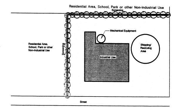
(Ord. 6-2001 § 1)
19.85.060 Building height.
The following building height standards are intended to promote land use compatibility and flexibility for industrial development at an appropriate community scale:
A. Base Requirement. Buildings shall be no more than three stories or 45 feet in height, whichever is greater, and shall comply with the building setback standards in FMC 19.85.030.
B. Performance Option. The allowable building height may be increased to 55 feet, when approved as part of a conditional use permit. The development approval may require additional setbacks, stepping-down of building elevations, visual buffering, screening, and/or other appropriate measures to provide a height transition between industrial development and adjacent nonindustrial development. Smoke stacks, cranes, roof equipment, and other similar features which are necessary to the industrial operation may not exceed 20 feet in height without approval of a conditional use permit.
C. Method of Measurement. “Building height” is measured as the vertical distance above a reference datum measured to the highest point of the coping of a flat roof or to the deck line of a mansard roof or to the average height of the highest gable of a pitched or hipped roof. The reference datum shall be selected by either of the following, whichever yields a greater height of building:
1. The elevation of the highest adjoining sidewalk or ground surface within a five-foot horizontal distance of an exterior wall of the building when such sidewalk or ground surface is not more than 10 feet above the lowest grade;
2. An elevation 10 feet higher than the lowest grade when the sidewalk or ground surface described in subsection (C)(1) of this section is more than 10 feet above the lowest grade. The height of a stepped or terraced building is the maximum height of any segment of the building. Not included in the maximum height are: chimneys, bell towers, steeples, roof equipment, flagpoles, and similar features which are not for human occupancy. (Ord. 6-2001 § 1)
19.85.070 Special standards for certain uses.
A. Uses With Significant Noise, Light/Glare, Dust, Vibration, or Traffic Impacts. The following uses shall require conditional use permit approval, in addition to development review or site design review:
1. Uses with Significant Noise, Light/Glare, Dust and Vibration Impacts. Uses which are likely to create significant adverse impacts beyond the industrial district boundaries, such as noise, light/glare, dust, or vibration, shall require conditional use approval, in conformance with Article IV of this title. The following criteria shall be used in determining whether the adverse impacts of a use are likely to be “significant”:
a. Noise. The noise level beyond the property line exceeds 65 dBA (24-hour average) on a regular basis.
b. Light/Glare. Lighting and/or reflected light from the development exceeds ordinary ambient light and glare levels (i.e., levels typical of the surrounding area).
c. Dust and/or Exhaust. Dust and/or exhaust emissions from the development exceeds ambient dust or exhaust levels, or levels that existed prior to development.
2. Traffic. Uses which are likely to generate unusually high levels of vehicle traffic due to shipping and receiving. “Unusually high levels of traffic” means that the average number of daily trips on any existing street would increase by 10 percent or more as a result of the development. The city may require a traffic impact analysis prepared by a qualified professional prior to deeming a land use application complete, and determining whether the proposed use requires conditional use approval. Applicants may be required to provide a traffic analysis for review by ODOT for developments that increase traffic on state highways.
3. Resource extraction, such as the operation of mineral and aggregate quarries and similar uses, shall require a conditional use permit in conformance with Article IV of this title. The applicant shall also be required to prepare a site reclamation plan for review and approval by the city and other affected agencies, prior to commencing resource extraction. The required scope of the reclamation plan shall be identified by the conditional use permit, and shall comply with applicable requirements of state natural resource regulatory agencies.
B. Residential Caretakers. One residential caretaker unit shall be permitted for each primary industrial use, subject to the following conditions:
1. The unit shall be served with public water and sanitary sewerage disposal, in conformance with city engineering requirements.
2. Caretaker units shall be required to meet applicable fire safety and building code requirements, in addition to the applicable setback standards of this chapter.
C. Wireless Communication Equipment. Wireless communication equipment includes radio (i.e., cellular), television and similar types of transmission and receiving facilities. The requirements for wireless communication equipment are provided in Chapter 19.245 FMC. Wireless communication equipment shall also comply with required setbacks, lot coverage and other applicable standards of the general industrial district.
D. Columbia River Uses Located North of Marine Drive.
1. Lot Coverage. The maximum allowable lot coverage in the general industrial district is 90 percent. The maximum allowable lot coverage is computed by calculating the total area covered by buildings and impervious (paved) surfaces, including accessory structures. Compliance with other sections of this code may preclude development of the maximum lot coverage for some land uses.
2. Building Height. The following building height standards are intended to promote land use compatibility and flexibility for industrial development at an appropriate community scale:
a. Base Requirement. Buildings shall be no more than 60 feet in height, and shall comply with the building setback/height standards in FMC 19.85.030, unless subject to additional standards in the airport overlay zone.
b. Performance Option. The allowable building height may be increased to 70 feet, when approved as part of a conditional use permit. The development approval may require additional setbacks, stepping-down of building elevations, visual buffering, screening, and/or other appropriate measures to provide a height transition between industrial development and adjacent non-industrial development. Smoke stacks, cranes, roof equipment, and other similar features, which are necessary to the industrial operation, may not exceed 20 feet in height without approval of a conditional use permit.
c. Method of Measurement. “Building height” is measured as the vertical distance above a reference datum measured to the highest point of the coping of a flat roof or to the deck line of a mansard roof or to the average height of the highest gable of a pitched or hipped roof. The reference datum shall be selected by either of the following, whichever yields a greater height of building:
i. The elevation of the highest adjoining sidewalk or ground surface within a five-foot horizontal distance of an exterior wall of the building when such sidewalk or ground surface is not more than 10 feet above the lowest grade;
ii. An elevation 10 feet higher than the lowest grade when the sidewalk or ground surface described in subsection (D)(2)(c)(i) of this section is more than 10 feet above the lowest grade. The height of a stepped or terraced building is the maximum height of any segment of the building. Not included in the maximum height are: chimneys, bell towers, steeples, roof equipment, flagpoles, and similar features which are not for human occupancy.
Figure 19.85.070 – Building Height Measurement (Composite of Several Roof Forms)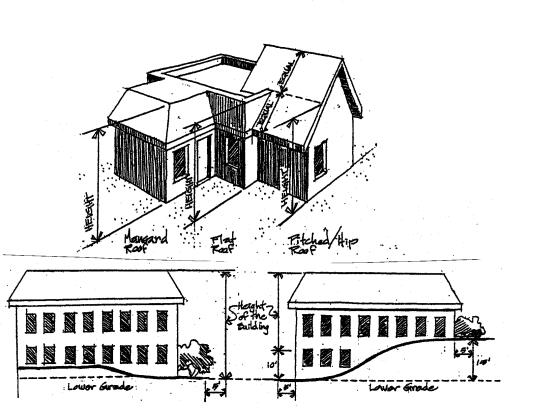
(Ord. 6-2001 § 1)
19.85.080 Special standards for city of Fairview adopted Metro Title 4 industrial properties.
A. The purpose of this section is to impose special standards to protect and preserve the supply of industrial lands in Fairview in accordance with the limitations set out in Title 4 of Metro’s Urban Growth Management Functional Plan (see Figure 9-C in the Comprehensive Plan for all Fairview Adopted Title 4 Industrial and Employment Lands).
1. Limitation on Retail/Commercial Service Land Uses. Retail and commercial service uses (in accordance with FMC 19.85.020) are limited in size to a maximum of 5,000 square feet in gross floor area for a single outlet (e.g., convenience market, small restaurant, secondary use for wholesaler, similar use) and up to 20,000 square feet in gross floor area for a multi-building project.
2. Freight Network Analysis Required. A freight network impact statement is to be included in all traffic studies for proposed developments on properties identified as industrial lands in Title 4 of the Metro Urban Growth Management Functional Plan. The purpose of this statement is to analyze potential adverse effects of the proposed development on the regional freight system as identified in the regional transportation plan (RTP) and the Fairview transportation system plan. Freight routes located in Fairview include Interstate 84, Marine Drive, 223rd Avenue, Fairview Parkway, Sandy Boulevard, and Glisan Street.
3. Land Division Standards. Properties in the general industrial district that are identified as industrial lands as shown on the Title 4 Properties Map in the Comprehensive Plan shall be subject to certain land division restrictions. All land divisions in the general industrial district shall be in accordance with Chapter 19.430 FMC, Land Divisions and Lot Line Adjustments.
B. The following standards shall apply to all general industrial properties included in the Fairview Title 4 industrial land inventory:
1. Lots smaller than 50 acres may be divided into any number of smaller lots.
2. Lots 50 acres or larger may be divided into smaller lots and parcels pursuant to a master plan approved by the city or county so long as the resulting division yields at least one lot or parcel of at least 50 acres in size.
3. Lots 50 acres or larger may be divided (including those created pursuant to subsection (B)(2) of this section) into any smaller lots or parcels pursuant to a master plan approved by the city or county so long as at least 40 percent of the area of the lot or parcel has been developed with industrial uses or uses accessory to industrial use. (Ord. 5-2009 § 1 (Att. 1))