


GENERAL BACKGROUND
Geographic Description
Marion County is located in northwest Oregon, in the central section of the Willamette River Basin. The Willamette Basin extends over 12,145 square miles between the crests of the Cascade and Coast Ranges and is drained by the Willamette and Sandy Rivers. The Willamette Basin is a major component of the Columbia River Basin. Generally rectangular in shape, the Willamette Basin is about 150 miles long and about 75 miles wide. The basin is bounded on the east by the Cascade Range, on the south by the Calapooya Mountains, on the west by the Coast Range, and on the north by the Columbia River, from Bonneville Dam to St. Helens, Oregon. Within the basin, elevations vary from less than 10 feet above mean sea level along the Columbia to 450 feet on the valley floor at Eugene. Elevations in the Cascades are over 10,000 feet and in the Coast Range they are approximately 4,000 feet.
Willamette Valley trough lies within the western half of the basin. With an area of approximately 3,500 square miles, the Valley extends almost the length of the basin at an average width of 30 miles. The generally level to gently rolling topography is interrupted by several groups of hills and scattered buttes.
Marion County is located slightly north of the approximate geographic center of the Willamette Basin. It is bounded on the north and west by the Willamette River, on the south by the North Santiam River, and on the east by the Pudding River, Butte Creek, and the crest of the Cascade Range. Measured east to west, the County is approximately 72 miles at its widest point and 12 miles at its narrowest point. From north to south, the County ranges from 41 miles to 10 miles in length. The total area of the County is 746,240 acres. Salem, Oregon’s capital city and the seat of Marion County, is located in the extreme western part of the County, adjacent to the Willamette River. Portland is approximately 47 miles north of Salem and Eugene is approximately 64 miles south of Salem. 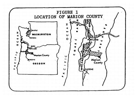
Settlement History
Kalapuyan Indian tribes were the major valley inhabitants prior to any settlement of white people. Each spoke their own dialect and names of tribes and bands such as Santiam, Yamhill, Lakmiute, Chemeketa and Chemawa are still commonly used.
The first settlements established in the Valley were fur trading centers. Around the latter part of 1812, the first such “trading house” was constructed on the present site of Salem by William Wallace and J.C. Halsey, two clerks associated with the Astor enterprise. By 1830, farms had been established in the French Prairie area, now part of northern Marion County. The population of the Valley in 1841 has been estimated at only 140 persons. However, by that date the farms of the Valley were already exporting livestock, butter, cheese and hides. Exporting of surplus timber had begun nearly 10 years earlier. After 1841, settlement increased rapidly – the population of the Valley reached 6,000 by 1845.
Organized government came to Oregon Country in 1843 with the establishment of a provisional government, thus ending a period of mutual occupancy by Great Britain and the United States which had begun in 1818. On July 5, 1843, the Provisional Government Legislative Committee created the governmental subdivision which is now Marion County.
Climate
Marion County has a temperate maritime climate with moderately warm, dry summers and mild, wet winters. The varying topography produces some variations in the climate depending primarily on elevation.
The outstanding characteristic of the County’s climate is the seasonal distribution of precipitation. About 60 percent of the annual precipitation occurs during the November through February winter storm season while only 10 percent occurs during the June through September dry season.
The average annual precipitation is as low as 40 inches in the western portions of the County but increases rapidly with elevation to 100 to 130 inches in parts of the Cascade Mountains in the eastern portions of the County. Below 2,000 feet elevation, most of the precipitation occurs as rain. Intensity of precipitation and the proportion of precipitation that is snow increases with elevation. The percentage of annual precipitation that occurs as snow increases from about two percent on the floor of the Valley region to 50 percent at 5,000 feet elevation and about 75 percent at 7,000 feet. Winter snow accumulations are quite large in much of the Cascades where they are an important source of summer streamflows. Summer precipitation in the County is limited to occasional light rainstorms and thunderstorms and frequently there are periods of 60 to 90 days when no rainfall occurs.
The prevailing winds are from the west and northwest during the summer and from the south and southwest during winter storm periods. Wind velocities are moderate, although strong winds sometimes accompany winter storms and short periods of strong easterly or northerly winds may occur at any time of the year. Periods of easterly winds bring cold, clear weather in winter and exceptionally dry, warm weather in summer.
Seasonal temperature variations are small in the Valley area of the County. Winter temperatures below 10 degrees (Fahrenheit) and summer temperatures above 100 degrees are rare. Maximum temperatures at Salem during the four summer months normally range from 74 to 82 degrees, although maximum daily temperatures as high as 110 degrees have been recorded. The normal minimum January temperature is 32 degrees. Some freezing of short duration occurs in the Valley every winter. Temperatures in the Cascades are generally cooler and the seasonal variations are greater than elsewhere in the County.
The frost-free season in most of the Valley area of the County is from April to October, a period of 180 to 200 days. At Salem, the average date of the last killing frost is April 3rd, and the first is November 1st, making a long frost-free season (212 days). The frost-free season decreases with increasing elevations to less than 30 days at the higher elevations in the Cascades.
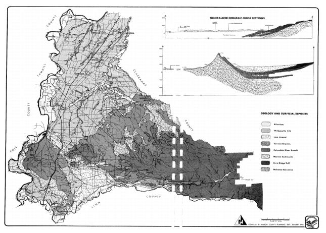
Geology and Surficial Deposits
There are three major physiographic provinces within the Willamette Basin: the Coast Range, the Willamette Trough and the Cascade Range. These different physiographic areas have differing geologic structures. The Coast Range is an anticlinal uplift, the Willamette Trough is a sedimentary basin, and the Cascade Range is of volcanic origin. Both the Willamette Trough and the Cascade Range occur within Marion County.
Creation of the Willamette Valley Trough resulted from downfolding of the regional bedrock formations. At the same time, the Coast Range was being formed by an uplifting action. The resulting elongated basin (the Willamette syncline) has subsequently been filled with sediments derived from erosion of the Coast and Cascade Ranges. The syncline is not only a major element in the structural geology of Marion County, but it has also resulted in the creation of major topographical features. The bedrock of the syncline, composed of marine sediments and basalt, is exposed in the Waldo Hills and Salem Hills. The same bedrock units are also exposed in the Eola Hills of Polk County, adjacent to and west of Marion County. Between Eola Hills and the Waldo Hills, the bedrock formation bows downward, and from the Salem Hills, the resulting trough dips northeasterly out of the County.
The foregoing brief remarks concerning the structural geology of the County are intended only as a framework within which to view the following descriptive information on the major geologic formations within the County. A clearer picture of the structural geology should emerge from reading the text on the formations and by referring to the accompanying geology map. The map “Geology and Surficial Deposits” shows the geographic location within the County of the major geologic formation exposures. Also shown are two cross-sections, which indicate the stratigraphic relationships of the formations. Generally, the text describes the nature of the material in the formation and the types of soils that are developed from these materials, and also engineering and groundwater characteristics of each.
Alluvium
This formation consists of gravels, sand, silt, clay and peat deposited in stream channels and on modern floodplains. Material sources are rock formations of the stream headwaters and all the formations through which the stream courses. Deposits within the stream channel itself are generally gravel and sand. However, within the channels of slower moving streams, the deposits are of a smaller particle size, ranging from silt to clay.
Only the Willamette and Santiam Rivers have developed significant floodplains and associated deposits. Floodplain deposits are mainly sand and silt, but may include clayey material in areas subject to back flooding and other areas of very slow-moving or stagnant floodwaters.
Generally, the particle size of the sediments ranges from coarse to fine away from the stream channel and from fine to coarse from the ground surface downward.
Since this area is subject to flooding, it is usually not used for building sites. However, in addition to flood hazard limitations, much of the area has an additional characteristic, which limits the potential for building sites. The unconsolidated fine gravel and soils of the modern floodplain provide low foundation strength and area inadequate for moderate to heavy structures. However, a more suitable foundation material, semi-consolidated gravel, can usually be found beneath the surface materials at shallow depths.
Alluvial deposits of the Willamette River floodplain extend to a depth of about 50 to 75 feet. Moderate to large quantities of groundwater are available from this formation. Most wells tap highly permeable gravels at depths of less than 50 feet with average yields of about 500 GPM (gallons per minute). However, specific capacity ranges from about four GPM to as much as 700 GPM per foot of drawdown. Santiam River floodplain alluvial deposits only extend to depths of 25 to 40 feet and are composed mainly of coarse, highly permeable gravels, which yield large amounts of water. Well yields are frequently 500 GPM or greater.
Willamette Silt
As can be seen from the geologic map, this formation covers an extensive area within the County. The formation extends to an average depth of about 70 feet. The formation is composed of individual stratified beds of silt, sandy silt, clayey silt and silty clay; thickness of the beds ranges from six inches to three or four feet. At the surface of the formation, the materials can be separated into three classifications by particle size: a clay phase, a clayey silt phase, and a silt phase.
The clay soil occurs in the French Prairie on flat, poorly drained, undissected terraces and may be from three to four feet thick to as much as 15 feet thick. Permeability in this soil is very restricted and the winter water table is nearly at the surface. During heavy rainfall, ponding may be expected. Restricted permeability is also a characteristic of the clayey silt soil, which generally occurs at the margins of the more clayey soil on flat or very gently sloping surfaces. The silt soils, located on the sloping edges of the terraces, are generally well drained. However, during the winter months, the water table will fluctuate and be very close to the ground surface during periods of heavy rainfall.
Soils within the Willamette Silt formation can generally provide adequate foundation support for light to moderate structural loads. When structural settlement cannot be tolerated, or for heavy structures, the structural load must be transferred to more suitable formations by means of pilings.
Groundwater from the Willamette Silt formation is generally adequate for domestic purposes. Most wells are completed in sand at the base of the formation. However, the primary source of groundwater is from formations which underlie the Willamette Silts, the Troutdale Formation and the Linn Gravel.
Linn Gravel
This formation occurs in the area west of Stayton, as shown on the geology map. As indicated by cross-section BB on the geology map, the formation also lies beneath the part of the Willamette Silt formation that occurs along the Santiam River in the southern part of the County. Generally, the Linn Gravel ranges in thickness from 30 to 40 feet. However, at Turner Gap it is over 100 feet thick. The “gravel” of this formation averages about three inches in diameter but often ranges up to eight or 10 inches or more in diameter. Material composition is mostly basalt, but andesite, dacite, thyolite, quartz and diorite also commonly occur. Layers of clay and silt occur in many areas of the gravel. Clay and silt within the interstices of the gravel act as a cement. Where these cemented strata occur, groundwater flow and surface water drainage characteristics are greatly restricted.
This formation can be expected to produce moderate to large amounts of groundwater. Well records in the Ankeny Bottom area indicate yields of about 100 GPM at less than 50 feet. While the gravels are generally highly permeable, the clay and silt layers locally may reduce the capacity of the gravel to produce large quantities of water.
Terrace Gravels
These gravels are the erosional remnants of gravel fans or terraces and are very limited in extent within Marion County, occurring only along the Santiam River. At the surface, the gravels are weathered to heavy impermeable clay. Patterns and outlines of the original pebbles and gravel from which the clay developed may still be distinguished. Subsurface extent of the formation is much greater than the surface exposure, and weathering has probably not been as great as at the surface. However, the characteristics may be much the same. Poor subsurface drainage is to be expected with the additional possibility of poor foundation characteristics.
Troutdale Formation
Surface exposure of the Troutdale Formation occurs only at a few places along the Willamette River downstream from St. Paul. Because of the limited extent of surface expression, it has not been shown on the geology map. However, this formation has an extensive subsurface coverage. It underlies all of the surficial deposits of the northern part of the County, i.e., the Alluvium and the Willamette Silt formations. The stratigraphic relationship of these formations is depicted by the cross-sectional diagram AA on the geology map.
Thickness of the formation varies considerably. In the northern part of the County, it has been measured and recorded on well logs as extending to depths greater than 650 feet with a thickness of about 550 feet. It is probably even thicker at the deepest part of the bedrock trough in which it lies. And as shown on cross-section AA, the formation becomes progressively thinner towards the east as it terminates against the Waldo Hills and Silverton Hills.
These sediments consist mainly of layers of clay, silt, sand and gravel alternating with locally cemented gravel and conglomerate. Because these sediments are mainly coarse-grained and have a high water-holding capacity, and because they cover such a large area, this formation is one of the major groundwater supply units in the Willamette Valley.
The whole area has excellent potential for development of moderate to large quantities of groundwater from wells. Variability in quantity is due mainly to the nature of the sedimentary layer being tapped with the higher quantities coming from beds with a high percentage of gravel. Through the study of well log records this formation has been divided into two major units according to the percentage of gravel occurring with the area. An area of 25 percent or less gravel content occurs in a triangular-shaped area bounded by St. Paul, Donald and St. Louis. The remainder of the area, from Salem northeasterly to Aurora, is composed of material which is from 25 percent to 100 percent gravel.
Well depths in the St. Paul-Donald subarea are usually in the range of 100 to 200 feet and are completed in sand or fine gravel. Yields are ordinarily greater than 100 GPM and many wells yield 500 GPM or more. A few wells have yields greater than 1,000 GPM. In the Salem-Aurora subarea, well logs indicate that coarse gravel or gravel and sand layers exist at depths ranging from 100 to 200 feet. Wells completed within these layers can be expected to yield moderate to large quantities of water. Common yields are 500 GPM or over, with some wells producing as much as 1,600 GPM.
Columbia River Basalt
This bedrock formation is exposed extensively in the Salem Hills south of Salem, in the Waldo Hills east of Salem, and in the Silverton Hills south of Silverton. As can be seen from both geologic cross-sections, this formation is underlain by marine sedimentary rocks. General composition of the formation is of basaltic lavas, as the name implies. However, there are also thin interbeds of sedimentary rocks in addition to the lavas. Thickness of the Columbia River Basalt formation ranges from 200 to 600 feet.
Fresh basaltic lava is hard and blue-black in color and has a characteristic jointed pattern. Weathering of exposed basalts results in red clay. The amount of weathering that has taken place in the basalts within the County varies considerably from place to place. In some areas, the red clay extends to depths of 30 feet and occasionally to 60 or 70 feet. Other areas appear to be only slightly weathered at the surface. Large, rounded residual boulders are likely to exist at the surface and in the subsurface where the weathering has been deep.
Groundwater tables within the basaltic lavas are largely perched above the valley water table. As an aquifer, the lavas may be expected to yield low to moderate amounts of water. High yields of several hundred gallons per minute (to as much as 1,000 GPM in a few instances) are generally obtained in rubbly interflow zones. However, yields are usually in the 10 to 30 GPM range. Development of this aquifer in the Salem Hills has been heavy, and because of low storage capacity, it is now subject to overdevelopment.
Marine Sediments
Exposure of this bedrock formation occurs only on the westerly to southerly facing escarpment of the Salem Hills, and in some locations in the Waldo and Silverton Hills east of Salem. Subsurface coverage is extensive. The marine sedimentary rocks are present throughout the entire Willamette Valley and, as shown by the geologic cross-sections, they generally occur beneath the Columbia River Basalt. Total thickness of the sedimentary rocks may be more than 7,000 feet.
Composition of the sediments is largely sandstone, shale, and siltstone, which is made up of a considerable amount of volcanic ash. The rocks are well consolidated and hardened. At ground surface to several feet into the subsurface, the rocks are frequently weathered to heavy plastic clay, which is quite impermeable and subject to landslides.
Only small amounts of groundwater are available from the marine sediments. Groundwater occurrence is generally limited to the fractures and joints in the shale bedrock. Wells usually produce less than five GPM but occasionally will yield 20 GPM or more. In some areas, the water is saline or has high sulfur content and is unusable.
Fern Ridge Tuff
Fern Ridge Tuff is exposed in the hills north and to the east of Stayton. Composition is mainly of volcanic ash and pumice, which occur in the form of breccia, sandstone, pebble beds and conglomerates. Surface weathering of this material results in a heavy impermeable clay, which is often several feet thick. Beneath the surface, the tuff is usually hardened. In some isolated areas of the formation, platy andesitic lavas occur within the upper segments. However, these lava overlays may be thin.
Groundwater availability is somewhat variable according to the Willamette Basin Hydrology study.1 Within the Fern Ridge formation, water yields of about 50 GPM at depths ranging from 100 to 300 feet may be obtained. Yields from the Columbia River formation where it underlays Fern Ridge range from 100 to 1,000 GPM also at 100 to 300 feet deep.
Mehama Volcanics
These rocks are exposed at locations adjacent to the North Santiam River east of Mehama. Stratigraphically, they are located beneath the Columbia River Basalt in this area. Exposed thickness of the formation varies between 300 and 400 feet, but the total thickness is much more. Rock types within the formation vary from lava to volcanic ash. Careful exploration is needed to locate the most favorable sites for wells. Yields of 50 GPM may be found at depths ranging from 100 to 300 feet.
1
Willamette Basin Comprehensive Study, Water and Related Land Resources, Appendix B Hydrology, 1969, Willamette Basin Task Force, Pacific Northwest River Basins Commission.