


Chapter 16.54
SHORELINE MODIFICATIONS
Sections:
16.54.020 Shoreline stabilization.
16.54.050 Clearing and grading.
16.54.060 Dredging and disposal.
16.54.080 Shoreline restoration and ecological enhancement.
16.54.010 General.
The following general requirements shall apply to all shoreline modifications:
A. In addition to the requirement of this chapter, all uses and modifications within the shoreline jurisdiction shall also comply with the regulations established in Chapter 16.52 BLMC, Shoreline Uses and Developments.
B. All shoreline modifications shall comply with the applicable requirements established by Chapter 16.56 BLMC, General Shoreline Regulations.
C. Shoreline modification activities which do not support a permitted use are considered “speculative” and are prohibited by this SMP, unless it can be demonstrated that such activities are necessary to protect human health and safety, ecological functions, and the public interest.
D. Stream realignment shall be prohibited as a means of shoreline stabilization.
E. Shoreline modification materials shall be only those approved by the city and applicable state agencies. No toxic (e.g., creosote) or quickly degradable materials (e.g., plastic or fiberglass that deteriorates under ultraviolet exposure) shall be used. (Ord. 1633 § 31, 2020; Ord. 1491 § 15, 2014).
16.54.020 Shoreline stabilization.
A. New development shall be located and designed to avoid the need for future shoreline stabilization to the extent feasible.
B. New or enlarged structural shoreline stabilization measures to protect an existing primary structure or in support of either a new water-dependent or nonwater-dependent development including a single-family residence shall not be allowed, except in circumstance when a geotechnical report demonstrates all of the following:
1. That nonstructural shoreline stabilization measures are not sufficient or are not feasible. In determining sufficiency and feasibility, all of the following shall be addressed in the geotechnical report:
a. Site conditions, including slope, beach configuration, nearshore depth, potential for flooding, and proximity of primary structure to the OHWM;
b. Consideration of wind direction, velocity and frequency, fetch, probable wave height, and frequency;
c. The level of risk to the primary structure presented by the rate of erosion over a three-year period;
d. Whether the cost of avoiding disturbance of shoreline processes and functions is disproportionate as compared to the environmental impact of proposed disturbance, including any continued impacts on functions and values over time.
2. The need to protect the existing or proposed primary structure from damage due to erosion caused by natural processes, such as currents or waves.
3. That the erosion is not being caused by upland conditions which can be addressed landward of the OHWM through the use of vegetation enhancement and/or low impact development.
4. That the size of the structural shoreline stabilization measures is limited to the minimum necessary to prevent damage to the primary structure or to support either the new water-dependent or nonwater-dependent development.
5. Confirmation that there is a significant possibility that the primary structure will be damaged within three years as a result of shoreline erosion in the absence of such structural shoreline stabilization measures, or where waiting until the need is that immediate would foreclose the opportunity to use measures that avoid impacts on ecological functions.
C. When structural shoreline stabilization measures are allowed pursuant to subsection B of this section, the stabilization measures shall comply with all of the following:
1. New shoreline stabilization measures shall be located at or behind the OHWM. Where a documented area of special flood hazard exists, stabilization measures shall be located at the upland edge of the area of special flood hazard, except that soft stabilization measures may be located in the area of special flood hazard.
2. Soft shoreline stabilization that restores ecological functions may be permitted waterward of the OHWM; provided, that the intent is not to create dry land.
3. Hard shoreline stabilization measures may only be used upon demonstration that soft shoreline stabilization measures are not to be sufficient to protect primary structures. The insufficiency and infeasibility of soft shoreline stabilization measures shall be addressed in a geotechnical report utilizing the criteria established in subsection (B)(1) of this section.
4. The construction of a bulkhead or other structural shoreline stabilization measure for the primary purpose of creating dry land is prohibited.
5. Adequate toe protection and proper footings shall be provided to ensure bulkhead stability without relying on additional riprap.
6. Bulkheads shall be designed to permit the passage of surface water or groundwater without causing ponding or oversaturation of retained soil/materials of lands above the OHWM.
7. Fill behind bulkheads shall be limited to the minimum level necessary to fill the terrain behind the bulkhead to match the existing grade. Any filling in excess of this amount shall be considered landfill and shall be subject to the provisions for landfill and the requirement for obtaining a shoreline substantial development permit.
D. The following materials are prohibited for shoreline stabilization structures:
1. Degradable plastics and other nonpermanent synthetic materials.
2. Sheet materials, including metal, plywood, fiberglass, or plastic.
3. Broken concrete, asphalt, or rubble.
4. Car bodies, tires or discarded equipment.
5. Solid waste.
6. Wood, timbers or other materials treated or coated with herbicides, fungicides, paint, pentachlorophenol arsenate compounds or creosote are prohibited.
E. Existing shoreline stabilization structures may be replaced with a similar structure if all of the following are demonstrated:
1. The replacement structure shall be designed, located, sized, and constructed to assure no net loss of ecological functions.
2. Replacement walls or bulkheads shall not encroach further waterward of the OHWM or existing structure unless the residence was occupied prior to January 1, 1992, and there are overriding safety or environmental concerns. In such cases, the replacement structure shall abut the existing shoreline stabilization structure.
3. For purposes of this section, “replacement” means the construction of a new structure to perform a shoreline stabilization function of an existing structure which can no longer adequately serve its purpose. Additions to or increases in size or height of existing shoreline stabilization measures shall demonstrate compliance with subsection B of this section. (Ord. 1491 § 15, 2014).
16.54.030 Piers and docks.
A. Only one pier or dock for moorage purposes shall be allowed per detached dwelling unit upon demonstrating compliance with the shoreline code. No additional pier, dock, or moorage space is allowed related to an accessory dwelling unit.
B. Renting, leasing or selling moorage space associated with a residential use is prohibited.
C. In the following circumstances, a joint use pier or dock shall be required:
1. On lots subdivided to create one or more additional lots with waterfront access rights.
2. New residential development of two or more dwelling units located on the same lot with waterfront access rights.
3. The requirement to provide and maintain a joint use dock in perpetuity shall be provided through either an easement recorded with the Pierce County auditor’s office or on the face of the plat or short plat recorded with the Pierce County auditor’s office. The legal description of the easement will be provided by the applicant on a form approved by the shoreline administrator.
D. A mooring buoy may be used to provide moorage space in lieu of a pier or dock. No more than one mooring buoy is permitted per detached dwelling unit.
E. Piers and docks shall be designed, used, and located so as not to constitute a hazard to navigation or other public uses of the water.
F. Piers and docks shall be constructed and maintained in a safe and sound condition. Abandoned, obsolete, or unsafe structures shall be removed or repaired promptly by the owner.
G. Piers or docks shall comply with the following dimensional standards:
|
Description |
Measurement |
|---|---|
|
Area |
|
|
Single property owner |
360 Square Feet |
|
Shared by 2 property owners |
580 Square Feet |
|
Shared by 4 or more property owners or dwelling units |
1,000 Square Feet |
|
Height |
|
|
Minimum height above the OHWM measured for the OHWM to the bottom of the stringers on the dock/pier |
1-1/2 Feet |
|
Maximum height above the OHWM measured from the OHWM to the top of the decking |
5 Feet |
|
Location of Specific Structures |
|
|
Minimum distance from docks/piers located on adjacent properties |
20 Feet |
|
Minimum distance between piers |
12 Feet |
H. The maximum intrusion of the elements of a pier and/or dock shall be only as long as needed to obtain a water depth of nine feet as measured from the elevation of the OHWM; provided, that the maximum length of the pier or deck shall not exceed 50 feet from the OHWM or 15 percent of the fetch, whichever is less. The length of the deck shall be measured as illustrated in Figure 1.
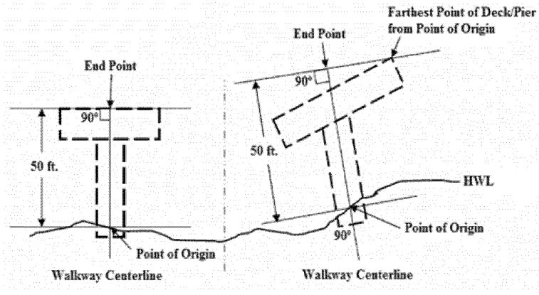
Figure 1: Maximum Length of Overwater Structures
I. All piers and docks shall comply with all of the following design standards:
1. No part or portion of a pier or dock, nor any accessory to a pier or dock such as a boat lift, shall extend beyond the limit of the shoreline frontage of a lot as determined using the methodology specified in BLMC 16.56.090. The width of a pier and/or dock may not exceed 25 percent of the length of a property’s shoreline frontage or 10 feet, whichever is less.
2. All utility and service lines located waterward of the OHWM must be located below the pier or dock deck and above the waterline.
3. The street address of the subject property must be displayed. The address must be oriented to the lake with letters and numbers at least four inches high.
4. Piers, docks, floats, and buoys shall be marked with reflectors, or otherwise identified to prevent unnecessarily hazardous conditions during the day or night. Exterior finish of all structures shall be generally nonreflective.
5. Piles, floats and other over-water structures that are in direct contact with water or over water shall comply with the following standards:
a. Piles treated or coated with herbicides, fungicides, paint, pentachlorophenol arsenate compounds or creosote are prohibited.
b. Piles shall be either steel, PVC, or untreated wood.
J. The following structures and improvements are prohibited:
1. Covered moorage, boathouses, or other walled covered moorage. Covered boat lifts in conformance with other provisions in this section may be allowed. Existing enclosed moorage structures shall be considered nonconforming uses subject to the provisions of BLMC 16.56.150.
2. Skirting on any structure.
3. Over-water residential use, including houseboats, live-aboards, or other single- or multifamily dwelling units.
4. Repealed by Ord. 1633.
5. New recreational floats and swimming platforms that do not meet the provisions related to temporary recreational equipment in this section.
K. Temporary recreational equipment (e.g., floating trampolines or floating swimming platforms) may be permitted from May 1st through September 30th. Temporary recreational equipment shall not impede navigation routes on Lake Tapps. All temporary recreational equipment shall be stored above the ordinary high water mark in a manner that does not damage shoreline vegetation during the times of year when the water level of Lake Tapps is reduced below recreational lake levels.
L. Repair and replacement of existing docks and/or piers that are accessory to a residential use shall comply with the following standards:
1. Proposals involving replacement of the entire private dock or 50 percent or more of the pier support piles shall conform to the provisions of the SMP; provided, that the area of the new dock may be equal to area of the existing dock.
2. Repair proposals which replace less than 50 percent of the existing pier support piles must comply with the requirements of subsection (I)(5) of this section.
3. Other repairs to existing legally established docks and piers where the nature of the repair is not described in subsections (L)(1) through (3) of this section shall be considered minor repairs and may be permitted upon demonstrating compliance with all other applicable codes and regulations.
4. If a single-family residence has two or more existing docks and one requires replacement or repair as described in regulations of subsections (L)(1) through (3) of this section, then one must be removed as a condition of the repair. The remaining dock may be improved to the maximum allowed dimensions in subsection G of this section and the other requirements of this section.
5. If the cumulative repair proposed over a three-year period exceeds thresholds established in subsection (L)(1) of this section, then deck or pier shall be brought into conformance with the SMP; provided, that the area of the new deck may be equal to area of the existing dock.
M. New additions to existing docks or piers may be permitted under the following circumstances:
1. When additional length is required to reach six feet of water depth as measured from the elevation at the OHWM.
2. When a single-use dock is converted to a joint-use pier.
3. New additions to existing docks shall not exceed any of the dimensional limits allowed for new docks.
4. When the addition will increase safety and usability.
5. When the total area of the dock, piers, and floats waterward of the OWHM is reduced.
N. Boat lifts and boat lift canopies may be permitted as an accessory to a dock or pier associated serving a detached dwelling unit or duplex; provided, that:
1. Residential docks may have up to two accessory personal watercraft lifts per residential lot.
2. Residential docks may have one accessory boat lift per residential lot.
3. All lifts are placed as far waterward as feasible and safe, within the limits of the dimensional standards for docks in this chapter.
4. The top of the canopy must not extend more than eight and one-half feet above the adjacent pier.
O. Temporary moorages shall be permitted for vessels used in the construction of shoreline facilities. The design and construction of temporary moorages shall be such that upon termination of the project, the aquatic habitat in the affected area can be returned to its original (preconstruction) condition within one year at no cost to the environment or the public. (Ord. 1633 § 32, 2020; amended during 10/14 supplement; Ord. 1491 § 15, 2014).
16.54.040 Fills.
A. Fills located waterward of the OHWM allowed pursuant to the use and modification table in BLMC 16.50.020 shall be demonstrated necessary to support a:
1. Water-dependent use;
2. Public access;
3. Cleanup and disposal of contaminated sediments as part of an interagency environmental cleanup plan pursuant to Chapter 70.105D RCW, Model Toxics Control Act (MTCA), Chapter 173-340 WAC, MTCA Cleanup Regulation, and/or the Comprehensive Environmental Response, Compensation, and Liability Act (CERCLA), commonly known as Superfund; or
4. Mitigation action, environmental restoration, beach nourishment or enhancement project.
B. Fills located landward of the OHWM allowed pursuant to the use and modification table in BLMC 16.50.020 shall only be allowed in support of a permitted use or development.
C. Fills shall be located, designed, and constructed to protect shoreline ecological functions and ecosystem-wide processes and shall not cause:
1. Significant damage to water quality, fish and aquatic habitat, and/or wildlife habitat; or
2. Adversely alter natural drainage patterns.
D. Refuse disposal sites, solid waste disposal sites, or sanitary fills are prohibited. (Ord. 1491 § 15, 2014).
16.54.050 Clearing and grading.
A. Clearing and grading activities shall only be allowed in association with a permitted shoreline development.
B. All clearing and grading activities shall comply with the following:
1. Materials such as dirt and rocks used in construction must be stored a minimum of 25 feet landward of the OHWM and shall incorporate best management practice measures to prevent erosion;
2. Any large quantities of vegetation removal and excess earthen materials shall be collected and disposed of in a manner to prevent negative impacts to the shoreline environment;
3. No vegetation or other enhancements installed as part of a restoration plan or mitigation shall be removed, unless approved by the city as part of a modified restoration plan or mitigation;
4. Surfaces cleared of vegetation shall be limited to the minimum necessary for the intended development, and shall be completely and effectively revegetated within six months of the clearing activity.
C. Clearing and grading is prohibited within the required vegetation conservation area, except for the following:
1. For the purpose of shoreline habitat and natural systems enhancement projects.
2. Associated with the development of a permitted use located within the required vegetative buffer or waterward of the OHWM as permitted by the SMP.
3. Clearing invasive nonnative shoreline vegetation listed on the Pierce County noxious weed list is permitted in shoreline locations, provided handheld equipment is used and native vegetation is reestablished in the disturbed area within six months from the date of the clearing activity.
4. As performed in the normal course of maintaining existing vegetation on a lot, provided such work:
a. Does not modify any drainage course.
b. Does not involve the importation of fill material, except as needed for mulch or soil amendment.
c. Does not result in erosion of the shoreline or undermine stability of neighboring properties.
d. Does not involve removal of native vegetation or vegetation installed as part of an approved restoration or enhancement plan.
e. Does not result in the compaction of existing soils in a manner that significantly decreases the ability of the soil to absorb rainfall.
f. Is the minimum extent necessary to reasonably accomplish the maintenance activity.
5. Correction of storm drainage improvements when supervised by the public works department.
6. As necessary to maintain or upgrade the structural safety of a legally established structure.
D. Exploratory excavations under the direction of a professional engineer licensed in the state of Washington may be allowed; provided, that the extent of the excavations does not exceed the minimum necessary to obtain the desired information. (Ord. 1633 § 33, 2020; Ord. 1491 § 15, 2014).
16.54.060 Dredging and disposal.
A. New development shall be located and designed to avoid the need for new or maintenance dredging.
B. Dredging shall be permitted only when significant ecological impacts are minimized, when mitigation is provided, and:
1. For the purpose of establishing, expanding, relocating, or reconfiguring navigation channels and basins where necessary for assuring safe and efficient accommodation of existing navigational uses; or navigational access and recreational access;
2. As part of an approved habitat improvement project;
3. To clean up contaminated sediments regulated under Chapter 70.105D RCW, Model Toxics Control Act, Chapter 173-340 WAC, Model Toxics Control Act Cleanup Regulations, and/or Comprehensive Environmental Response, Compensation and Liability Act.
C. When dredging is permitted, the dredging shall be the minimum necessary to accommodate the proposed use.
D. Dredging and dredge disposal shall be carefully scheduled to protect ecological function (e.g., spawning, benthic productivity, etc.) and to minimize interference with fishing activities.
E. Dredging shall utilize techniques which cause minimum dispersal and broadcast of bottom material.
F. Dredging for the primary purpose of obtaining material for fill is prohibited.
G. Depositing clean dredge materials within shoreline jurisdiction shall be allowed only by conditional use permit for one or more of the following reasons:
1. For wildlife habitat improvement or shoreline restoration; or
2. To correct problems of material distribution adversely affecting fish and wildlife resources. (Ord. 1491 § 15, 2014).
16.54.070 Dikes and levees.
A. Public access to shorelines should be an integral component of all levee improvement projects. Public access shall be provided in accordance with public access policies of the SMP and regulations contained in BLMC 16.56.120.
B. New dikes and levees may be allowed within the shoreline jurisdiction when all of the following are demonstrated by a scientific and engineering analysis that:
1. The dike or levee is limited in size to the minimum height required to protect adjacent lands from the projected flood stage.
2. The dike or levee is located landward of wetlands and designated vegetation conservation areas consistent with BLMC 16.56.060.
3. Nonstructural measures are not feasible.
4. Impacts on ecological functions and priority species and habitats can be successfully mitigated so as to assure no net loss.
C. Proper diversion of surface discharge shall be provided to maintain the integrity of the natural streams, wetlands, and drainages. (Ord. 1491 § 15, 2014).
16.54.080 Shoreline restoration and ecological enhancement.
A. Shoreline habitat and natural systems enhancement projects include the following activities when proposed and conducted specifically for the purpose of establishing, restoring, or enhancing habitat for priority species in shorelines:
1. Establishment or enhancement of native vegetation.
2. Removal plants that are identified on the Washington State Noxious Weed List, Chapter 16-750 WAC.
3. Voluntary conversion of hard structural shoreline stabilization to soft shoreline stabilization, including associated clearing, dredging and filling necessary to implement the conversion.
4. Implementation of any project or activity identified in the city’s restoration plan; provided, that the project or activity has not been identified as mitigation for a specific development or use of the shoreline.
B. Relief from the development standards of the shoreline code may be granted when a restoration project has resulted in a landward shift of the OHWM subject to the following provisions:
1. The standards established by the shoreline code may be modified as part of any shoreline permit without the requirement to obtain a separate shoreline variance or meet the criteria for a shoreline variance subject when all of the following criteria are met:
a. A shoreline restoration project caused OHWM shift landward resulting in:
i. Land that had not been regulated under shoreline code prior to construction of the restoration project is brought under shoreline jurisdiction, or
ii. Additional regulatory requirements apply due to a landward shift in required shoreline buffers or other regulations of the shoreline code;
b. Application of shoreline code would preclude or interfere with use of the property permitted by local development regulations, resulting in a hardship to the property owner;
c. The proposed relief is the minimum necessary to relieve the hardship;
d. After granting the proposed relief, there is net environmental benefit from the restoration project;
e. Granting the proposed relief is consistent with the objectives of the shoreline restoration project and the SMP; and
f. The restoration project was not created as mitigation to obtain a development permit.
2. The decision of the shoreline administrator to either approve or deny the request to modify the shoreline code standards pursuant to subsection (B)(1) of this section shall be forwarded to the Department of Ecology for review and either approval or disapproval.
3. Permits that rely on the provisions of subsection (B)(1) of this section shall not be issued unless the Department of Ecology approves the modification to the standards of the shoreline code. (Ord. 1491 § 15, 2014).