


Chapter 16.56
GENERAL SHORELINE REGULATIONS
Sections:
16.56.020 No net loss standard and mitigation sequencing.
16.56.030 Archaeological and historic resources.
16.56.040 Shoreline vegetation incentives.
16.56.050 Vegetation planting plan requirements.
16.56.060 Vegetation conservation and maintenance.
16.56.070 Water quality and quantity.
16.56.080 Methodology for calculating impervious area.
16.56.090 Methodology for determining shoreline frontage.
16.56.100 Permitted intrusions into shoreline setback.
16.56.150 Nonconforming and preexisting uses, structures, and developments.
16.56.010 Applicability.
The requirements of this chapter shall apply to all uses, activities, and developments within all SEDs. (Ord. 1491 § 16, 2014).
16.56.020 No net loss standard and mitigation sequencing.
A. All shoreline development and uses shall occur in a manner that results in no net loss of shoreline ecological functions, through the location and design of all allowed development and uses. Impacts to shoreline ecological functions from allowed development and uses shall be mitigated in the following sequence of steps listed in order of priority:
1. Avoid the impact altogether by not taking a certain action or parts of an action;
2. Minimize impacts by limiting the degree or magnitude of the action and its implementation by using appropriate technology or by taking affirmative steps to avoid or reduce impacts;
3. Rectify the impact by repairing, rehabilitating, or restoring the affected environment;
4. Reduce or eliminate the impact over time by preservation and maintenance operations;
5. Compensate for the impact by replacing, enhancing, or providing substitute resources or environments; and
6. Monitor the impact and the compensation projects and take appropriate corrective measures.
B. In the following circumstances, the applicant shall provide a written analysis prepared by a qualified professional regarding the compliance with measures taken to mitigate environmental impacts established in subsection A of this section:
1. When either a conditional use or variance application is proposed; and
2. When the standards contained in the shoreline code require an analysis of the feasibility of the need for an action, or to determine whether the design has been minimized in size.
C. Maintenance activities shall be conducted in a manner that minimizes impacts to critical areas and utilizes applicable BMPs.
D. When evaluating the feasibility of a proposed action, the applicant shall provide a report from a qualified professional demonstrating that the cost of avoiding disturbance is substantially disproportionate when compared to the environmental impact of the proposed disturbance, including any continued impacts on functions and values over time.
E. Failure to demonstrate that the mitigation sequencing standards have been met may result in permit denial. (Ord. 1491 § 16, 2014).
16.56.030 Archaeological and historic resources.
A. Development in areas documented by the Washington State Department of Archaeology and Historic Preservation or identified by affected tribes to contain archaeological resources shall comply with the following:
1. A site inspection and a written report shall be prepared by a qualified professional archaeologist. Copies of the report shall be provided by the applicant to the city; upon receipt of the report the city shall forward copies to affected tribe(s) and the Washington State Department of Archaeology and Historic Preservation for review and comment.
2. After consultation with these agencies, the archaeologist shall provide a final report that includes any recommendations from the affected tribe(s) and the Washington State Department of Archaeology and Historic Preservation on avoidance or mitigation of the proposed project’s impacts.
3. The shoreline administrator may condition project approval, based on the final report from the archaeologist in consultation with the affected tribes, to ensure that impacts to the site are avoided or minimized consistent with federal and state law.
B. All shoreline permits and letters of exemption shall contain provisions that require developers to immediately stop work and notify the city, the Washington State Department of Archaeology and Historic Preservation, and affected tribes if any potential archaeological resources are uncovered during land surface modification or development activity. Failure to comply with this requirement shall be considered a violation of the shoreline permit. (Ord. 1633 § 34, 2020; Ord. 1491 § 16, 2014).
16.56.040 Shoreline vegetation incentives.
A. The city’s “Final Shoreline Restoration Plan Component of the Shoreline Master Program for the City of Bonney Lake Shorelines: Lake Tapps and Fennel Creek” concludes that one of the primary opportunities that the city has to improve the water quality in Lake Tapps and improve shoreline ecological conditions in the city generally is to incentivize planting of native vegetation by private property owners in the vegetation conservation areas located in the 20 feet upland from the OHWM adjacent to their properties. This being the case, this section is designed to offer incentives to property owners living in the shoreline jurisdiction in exchange for planting and continued maintenance of native vegetation that, at maturity, will meet the standards found in BLMC 16.56.060.
B. The following requirements shall apply to all of the incentives in this section:
1. The shoreline vegetation provided for one incentive cannot be applied to another incentive.
2. Shoreline vegetation that already exists within the shoreline vegetation conservation area or is required to be planted pursuant to BLMC 16.56.060(B) shall not apply towards the incentives established in this section.
3. The vegetation shall be native vegetation planted adjacent to the shoreline.
4. The applicant shall submit a vegetation planting plan consistent with the requirements of BLMC 16.56.050.
5. The shoreline vegetation incentive is only available for properties located in the shoreline residential designation.
6. Any portion of the development proposal and/or planting that will involve property owned by Cascade Water Alliance or any other property owner must receive explicit written authorization, a copy of which shall be submitted to the city at the time of the project proponent’s submittal of materials for review.
C. The required minimum 60-foot shoreline setback may be reduced by five feet for every 300 square feet of shoreline vegetation installed along the shoreline provided:
1. The maximum amount of shoreline setback reduction is 20 feet; provided, that the primary structure does not move closer to the water than established by the string-line setback determined by subsection (C)(3) of this section.
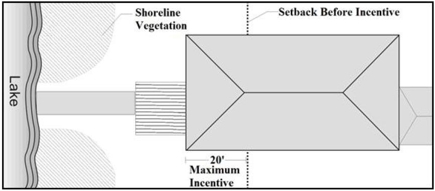
Figure 2: Shoreline Setback Bonus for Shoreline Vegetation
2. The primary structure maintains a minimum setback of 20 feet from the rear property line.
3. The primary structure does not move closer to the water than established by the string line as follows:
a. A string line is established by drawing a straight line between the two points where the residential use on each of the adjoining shoreline lots each projects the greatest towards and is the closest to the OHWM.
b. If the string-line setback is greater than 40 feet from the OHWM, the maximum reduction of the shoreline setback is the distance between the string line and the OWHM as illustrated on Figure 3.
c. A string-line setback is not required if one or both of the adjoining shoreline lots do not contain a residential use.
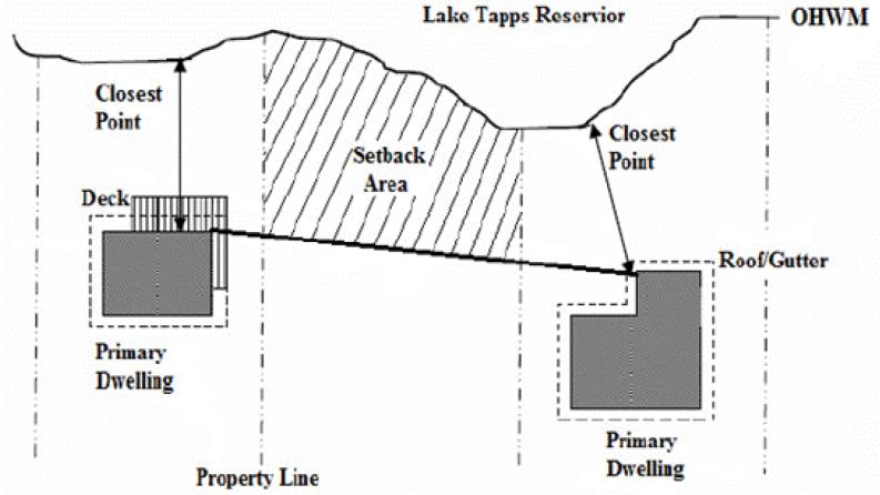
Figure 3: Example of Shoreline Setbacks for Middle Home Based on Average Adjacent Shoreline Setbacks
D. If there is no bulkhead, or if a bulkhead is removed, a small waterfront deck or patio can be placed along the shoreline provided:
1. The width of the waterfront deck or patio as measured parallel to the OHWM shall be equal to or less than 25 percent of the shoreline frontage and native vegetation covers a minimum of 75 percent of the shoreline frontage.
2. The deck shall be located within the same area allowed for the pathway and view corridor to the water provided in BLMC 16.56.100(B)(3).
3. For every one square foot of waterfront deck or patio, there shall be three square feet of native vegetation provided adjacent to the OHWM.
4. The total area of the waterfront deck or patio along the shoreline shall not exceed 150 square feet.
5. The deck or patio is set back five feet from the OHWM.
6. The deck or patio is no more than two feet above grade and is not covered.
7. There are no permanent structures above the level of the deck within 20 feet of the rear property line.
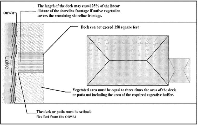
Figure 4: Waterfront Deck Bonus for Lots
E. The maximum allowed area for docks and piers allowed a single property owner and shared by two property owners established by BLMC 16.54.030(G) may be increased by 30 feet for every 300 square feet of shoreline vegetation provided along the shoreline. The maximum amount of additional area that can be obtained from this incentive is 120 square feet.
F. Property owners who own property that is separated from the OHWM by upland areas owned by CWA may include those upland areas of CWA’s property directly between their property and the OHWM as part of their lot area for purposes of calculating the allowed impervious surface on their lot, subject to all of the following criteria:
1. The property owner seeking to use CWA’s property area to calculate allowed impervious surfaces on the property shall enter into a license agreement with CWA.
2. The property owner seeking to use this incentive shall provide a vegetation planting plan that meets the requirements of BLMC 16.56.050, and agrees to maintain the vegetation conservation area in compliance with BLMC 16.56.060.
3. The allowed impervious surfaces will only be installed on the property owner’s private property. None of the impervious surfaces installed will be located on CWA’s property.
4. The impervious surfaces allowed on any property utilizing this incentive shall not exceed the impervious surface standards found in BLMC 16.40.030.
5. All other applicable setback and bulk regulations shall apply to the site subject to this incentive.
G. A property owner may be allowed to install a boathouse upland from the OHWM without a rear yard setback requirement, and without a shoreline setback requirement if all of the following standards are met:
1. The property owner shall obtain the approval of Cascade Water Alliance in the form of a valid license agreement for any structural development or vegetation planting and vegetation maintenance that involves property owned by CWA.
2. The city approves a vegetation planting plan for the entire vegetation conservation area within the lot frontage that meets all of the standards of BLMC 16.56.050 and 16.56.060.
3. The square footage of the structure is no greater than 150 square feet. The entire structure shall be located within the walkway corridor described in BLMC 16.56.100(B)(3) and illustrated in Figure 6.
4. The structure is no more than 10 feet in height, as measured according to the definitions of WAC 173-27-030.
5. The boathouse shall not be used to justify the need for shoreline armoring.
6. No rooftop deck or use shall be allowed or established on top of such a structure.
7. The boathouse shall not include habitable space or plumbing, and construction of a boathouse shall require a building permit regardless of size. (Ord. 1633 § 35, 2020; Ord. 1491 § 16, 2014).
16.56.050 Vegetation planting plan requirements.
Shoreline vegetation planting plans shall meet the following minimum requirements:
A. The plan shall be prepared by a qualified professional.
B. The plan shall be recorded with the Pierce County assessor’s office as a covenant against the property after approval by the shoreline administrator, and shall obligate the property owner to maintain the vegetation specified in the plan in perpetuity. A copy of the recorded covenant shall be provided to the city.
C. The native vegetation shall consist of a mixture of trees, shrubs and groundcover and be designed to improve habitat functions. All vegetation planted as a part of a shoreline vegetation planting plan shall be planted in the ground either on the property where the development will take place, or on land owned by CWA that lies between the OHWM, the property’s rear property line, and the side lot lines extended, as described in BLMC 16.56.090(A), subject to a valid CWA license agreement. The following general planting regulations shall apply:
1. Trees. A minimum of one native tree per 300 square feet of required vegetated area shall be provided or preserved. A minimum of 30 percent of the required trees shall be native coniferous trees.
a. Deciduous trees shall be a minimum of two-and-one-half-inch caliper as measured per American Standard for Nursery Stock (ANSI Z60.1-2004).
b. Coniferous trees shall be at least six feet high at the time of planting.
2. Shrubs. A minimum of one shrub per 20 square feet of landscape area shall be provided. The minimum size of the shrub at the time of planting shall be at least two feet in height, with the plant covering the dimensions of the container.
3. Vegetative Groundcover. Living groundcover plants of a minimum one-gallon size shall be planted in the landscaped area sufficient to cover the area within three years of planting. Grassy lawns will not be considered as acceptable vegetative groundcover.
4. Vegetation shall be fully established within three years. Areas which fail to adequately reestablish vegetation shall be replanted with approved plants until the plantings are viable.
5. The plan shall include limitations on the use of fertilizer, herbicides and pesticides as needed to protect water quality.
D. A four-year monitoring and maintenance program prepared by a qualified professional including, but not limited to, the following:
1. An outline of the schedule for site monitoring. Annual monitoring reports from an applicant’s qualified professional provided to the city shall be included as a part of such a schedule;
2. Performance standards, including, but not limited to, 100 percent survival of newly planted vegetation within two years of planting, and 80 percent for years three or more;
3. Contingency plans identifying courses of action and any corrective measures to be taken if monitoring indicates performance standards have not been met; and
4. The period of time necessary to establish performance standards have been met, not to be less than four years.
E. The city may require a financial security pursuant as a guarantee that the enhancements, maintenance and monitoring are completed to the satisfaction of the city. (Ord. 1633 § 36, 2020; Ord. 1491 § 16, 2014).
16.56.060 Vegetation conservation and maintenance.
A. The area 20 feet landward of the OHWM shall be considered vegetation conservation area. Existing native shoreline vegetation shall be preserved within the vegetation conservation area consistent with safe construction practices, and other provisions of this section. Native trees and shrubs shall be preserved to maintain and provide shoreline ecological functions.
B. Vegetation conservation areas shall be fully replanted with native vegetation pursuant to an approved vegetation planting plan consistent with the requirements of BLMC 16.56.050 and this section as part of the following development proposal:
1. Construction of a new detached dwelling unit, duplex, multifamily building either on a vacant lot or a lot on which a detached dwelling unit, trailer, manufactured home, duplex, or multifamily building was previous located.
2. An increase of at least 25 percent in gross floor area of any structure located in shorelines jurisdiction.
3. An alteration of a detached dwelling unit, duplex, multifamily building in shorelines jurisdiction, the cost of which exceeds 60 percent of the assessed value of the residential structures on the subject property as identified on the Pierce County auditor website.
4. As a required condition for any property owner that chooses to receive approval for a development project through use of the incentives that are specified in BLMC 16.56.040(F) and (G).
C. Twenty-five percent of the required vegetated conservation may be cleared or thinned for view maintenance and waterfront access as described in BLMC 16.56.100(B)(3); provided, that 75 percent of the area remains vegetated. Invasive species may be removed, vegetation trimmed, and trees “limbed up” from the ground to provide views.
D. In the instance where there is an intervening property between the OHWM and an upland property and the portion of the intervening property abutting the upland property has an average depth of less than 20 feet, shoreline vegetation shall be provided within the shoreline setback portion of the upland property pursuant to this section, unless:
1. The required shoreline vegetation already exists on the intervening lot; or
2. The intervening property owner agrees to allow the upland property owner to install the shoreline vegetation on their property.
E. Snags and living trees over six inches DBH shall not be removed within the vegetated portion of the vegetative conservation area except under the following instances:
1. A hazard or nuisance tree may be removed consistent with the following standards:
a. A qualified arborist retained by the property owner shall determine if the tree meets the definition of a hazard or nuisance tree provided in BLMC 16.36.110 and 16.36.170.
b. A “snag” or wildlife tree shall be created from the hazard tree. If a qualified arborist determines that the tree cannot or should not be used for a “snag” or wildlife tree, the tree may be removed from the vegetation conservation area and replacements planted within the vegetative conservation area using native tree species at a 3:1 replacement ratio. If a snag is created, replacement will be at a 1:1 ratio.
2. The removal is part of an approved development that includes mitigation for impacts to ecological functions.
F. For trees outside of the vegetation conservation areas of a lot, a tree removal request in the form of a shoreline exemption application shall be submitted in writing to the city prior to the removal of any tree. Any tree greater than four and one-half DBH removed from a property will be replaced elsewhere within the shoreline jurisdiction at a ratio of 1:1 with like-for-like species selection wherever feasible. The request shall include the location, number, type and size of tree(s) being removed and the proposed replacement tree(s) and planting plan. The city shall inspect the tree replacement once installation is complete.
G. Nondestructive thinning of lateral branches to enhance views or trimming, shaping, thinning or pruning shall comply with National Arborist Association pruning standards. No more than 25 percent of the limbs of any single tree may be removed and no more than 20 percent of the canopy cover in any single stand of trees may be removed for view preservation.
H. Aquatic weed control shall occur in compliance with all other applicable laws and standards in addition to the following:
1. The control of aquatic weeds by hand pulling, mechanical harvesting, or placement of aqua screens, if proposed to maintain existing water depth for navigation, is the preferred method.
2. When large quantities of plant material are generated by control measures, they shall be collected and disposed of in an appropriate, identified upland location.
3. Use of herbicides to control aquatic weeds shall be prohibited except for those chemicals specifically approved by the Department of Ecology for use in aquatic situations. The shoreline administrator must be notified of all herbicide usage in aquatic areas and supplied with proof of required approvals from the Department of Ecology.
4. All herbicides shall be applied by a licensed professional. (Ord. 1633 § 37, 2020; Ord. 1491 § 16, 2014).
16.56.070 Water quality and quantity.
A. All shoreline development shall comply with the applicable requirements of the Pierce County 2015 Stormwater Management and Site Development Manual and all applicable city stormwater regulations established by Chapter 15.13 BLMC, Stormwater Management.
B. All shoreline development shall implement, to the extent feasible, the low impact development techniques pursuant to the standards contained in the Pierce County 2015 Stormwater Management and Site Development Manual – Volume VI.
C. Repealed by Ord. 1633.
D. The direct runoff of chemical-laden waters into adjacent water bodies is prohibited. (Ord. 1633 § 38, 2020; Ord. 1491 § 16, 2014).
16.56.080 Methodology for calculating impervious area.
The percentage of impervious surface shall be calculated according to the following formula:
A. Percentage of impervious surface is equal to total footprint area of impervious surfaces, including all pavement, compacted gravel areas, and buildings, divided by total land area of the property multiplied by 100.
B. In calculating impervious surface, pavers on a sand bed may be counted as 50 percent impervious and wood decks with gaps between deck boards may be counted as permeable if over bare soil or loose gravel (such as pea gravel). Pervious concrete and asphalt may be counted as per manufacturer’s specifications, as proposed and verified by a qualified civil engineer. To calculate the net impervious surface of such an area, multiply the area of the pavement by the percentage of imperviousness.
C. The city may determine the percentage of imperviousness for pavements that are not specified here.
D. As an alternative to the above quantitative standards, the applicant may submit a stormwater retention plan, prepared by a licensed civil engineer or hydrogeologist. The plan may incorporate alternate means of addressing stormwater runoff impacts such as low impact development techniques, rain gardens, etc. In order to be approved, the plan must conclusively demonstrate that its implementation will result in a positive benefit in regards to the ecological functions at the site when compared to following the standards in subsections A through C of this section, and/or will result in less negative ecological impacts than following the prescriptive standards of subsections A through C of this section. (Ord. 1633 § 39, 2020; Ord. 1491 § 16, 2014).
16.56.090 Methodology for determining shoreline frontage.
Water frontage shall be measured in the following manner:
A. The two property lines intersecting the OHWM shall be continued waterward in a straight line; and
B. A centerline bisecting equal distances between the two property lines shall be established; and
C. A straight line perpendicular to the centerline shall be drawn between the two property lines with at least one end of the straight line affixed to a point where the OHWM intersects one of the property lines; and
D. The water frontage shall be measured as the length of the straight line created.
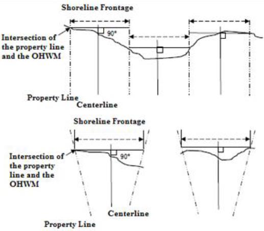
Figure 5: Determining Shoreline Frontage
(Ord. 1491 § 16, 2014).
16.56.100 Permitted intrusions into shoreline setback.
A. The following developments and modifications may be located in the portion of the required shoreline setback that is outside of the vegetation conservation area:
1. Underground utilities accessory to an approved shoreline use, provided there is no other feasible route or location.
2. Bioretention swales, rain gardens, or other similar bioretention systems that allow for filtration of water through planted grasses or other native vegetation.
3. Infiltration systems; provided, that installation occurs as far as feasible from the OHWM.
4. Bay windows, greenhouse windows, eaves, cornices, awnings, and canopies may extend up to 18 inches into the shoreline setback, subject to the following limitations:
a. Eaves on bay windows may extend an additional 18 inches beyond the bay window.
b. Chimneys that are designed to cantilever or otherwise overhang are permitted.
c. The total horizontal dimension of these elements that extend into the shoreline setback, excluding eaves and cornices, shall not exceed 25 percent of the length of the facade of the primary structure facing the shoreline.
5. Uncovered patios or decks may extend a maximum of 10 feet into the shoreline setback, subject to the following standards:
a. The improvement shall be constructed of a pervious surface, such as wood with gaps between boards and a pervious surface below, unit pavers, grid systems, pervious concrete, or, alternatively, equivalent material approved by the shoreline administrator.
b. The improvement shall not be closer than 20 feet to the rear property line.
c. The total horizontal dimension of the improvement that extends into the shoreline setback shall not exceed 50 percent of the length of the facade of the primary structure facing the shoreline.
d. The improvement shall be located on the ground floor of the building and shall not be elevated more than necessary to allow for grade transition from the structure to the deck or to follow the existing topography.
6. Appurtenances, dry boat storage and other similar accessory structures subject to the following:
a. Only one structure that is 200 square feet or less is permitted within the shoreline setback.
b. The structure shall maintain a minimum 20-foot setback from the rear property line unless exempt from the rear setback requirement, subject to the approval of the incentive in BLMC 16.56.040(F). Such a structure, subject to compliance with the provisions of BLMC 16.56.040(F), may also be located within part of the vegetation conservation area.
7. Retaining walls and similar structures that are no more than four feet in height above finished grade; provided the structure is not for retaining new fill to raise the level of an existing grade, but only to retain an existing slope prior to construction and installed at the minimum height necessary.
8. Public trails subject to the requirements of BLMC 16.52.030(E) and 16.56.110.
9. Utility transmission lines and municipal well facilities subject to the requirements in BLMC 16.52.070 and 16.56.110 where no other feasible location exists. Such structures shall be placed as far from the OHWM as feasible.
B. The following developments and modifications may be located in all portions of the required shoreline setback including the vegetation conservation area:
1. Shoreline stabilization measures approved under the provisions of BLMC 16.54.020.
2. Fences to delineate property boundaries no more than six feet in height which run perpendicular to the shoreline shall be allowed in the shoreline residential SED. Fences that run parallel to the shoreline are prohibited in all SEDs.
3. Private walkways within the shoreline setback and shoreline vegetative buffer may be permitted upon demonstrating compliance with the following standards:
a. The maximum width of the access corridor shall be no more than 25 percent of the property’s shoreline frontage, except in no case shall the corridor area be required to be less than 15 feet in width.
b. The walkway in the corridor area shall be no more than eight feet wide.
c. The walkway corridor area may contain minor improvements, such as garden sculptures, light fixtures, trellises and similar decorative structures that are associated with the walkway; provided, that these improvements comply with the dimensional limitations required for the walkway corridor area. Light fixtures approved under this subsection shall comply with the provisions contained in BLMC 16.56.120.
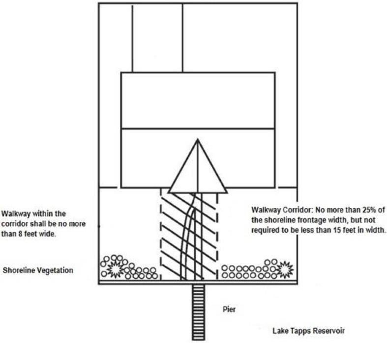
Figure 6: Maximum Walkway Corridor
C. Accessory structures, appurtenances, and other development not addressed in this section shall comply with the most stringent shoreline setback established for the underlying SED. (Ord. 1633 § 40, 2020; Ord. 1491 § 16, 2014).
16.56.110 Critical areas.
A. Critical areas located in the shoreline shall be regulated under the shoreline code.
B. The city of Bonney Lake critical areas code is incorporated into the shoreline code, except as noted below:
1. BLMC 16.20.145, Critical areas variances. Within shoreline jurisdiction, the shoreline variance process provided for in BLMC 16.58.050 shall be utilized to determine if relief may be granted from the critical areas code.
2. BLMC 16.20.170, Nonconforming uses. Within shoreline jurisdiction, nonconforming uses shall be regulated by BLMC 16.56.150.
3. BLMC 16.26.050, Floodplain variances. Within shoreline jurisdiction, the shoreline variance process provided for in BLMC 16.58.050 will be utilized to determine if relief may be granted from the floodplain code.
C. The exemptions provided in BLMC 16.20.070 only pertain to exemptions from specific standards within the critical areas code for specified activities; only shoreline use, developments, and modifications that are identified in BLMC 16.58.020(A) shall be exempt from a shoreline substantial development permit and must comply with the requirements of BLMC 16.58.020(B) through (J).
D. If provisions of the critical areas code and other parts of the shoreline code conflict, the provisions most protective of the ecological resource shall apply, as determined by the city. (Ord. 1491 § 16, 2014).
16.56.120 Public access.
A. The dedication and improvement of public access is required for the following development unless the conditions stated in subsection B of this section apply:
1. Land division into more than four lots.
2. Nonwater-oriented uses.
3. Multifamily residential development.
4. Water-related and water-enjoyment uses.
5. Development by public entities or on public land, including the city and public utility districts.
6. Development or use that will interfere with an existing public access way. Impacts to public access may include blocking access or discouraging use of existing on-site or nearby accesses.
B. Public access is not required as part of development if any of the following conditions apply:
1. The development is a single-family residence not part of a development planned for more than four parcels.
2. Public access is demonstrated to be infeasible or undesirable due to reasons of incompatible uses, safety, security or impact to the shoreline environment. In determining infeasibility or undesirability, the city shall evaluate alternative means of providing public access such as off-site improvements, separation of uses, and restricting the hours of public access to avoid conflicts.
3. Where the property is not adjacent to the shoreline because it is separated from the shoreline by another property, direct physical access to the shoreline is not required.
C. Pedestrian walkways installed to provide public access shall comply with the following standards:
1. The walkways shall be at least six feet wide, but no more than eight feet wide.
2. The walkways shall be distinguishable from traffic lanes by pavement material, texture, or change in elevation.
3. The walkways shall not be included with other impervious surfaces for lot coverage calculations.
4. Permanent barriers that limit future extension of pedestrian access between the subject property and adjacent properties are not permitted.
5. Regulated public access shall be indicated by signs installed at the entrance of the public pedestrian walkway on the abutting right-of-way and along the public pedestrian pathway. The signs shall be located for maximum public visibility.
6. Walkways shall be connected directly to the nearest public street or public right-of-way and shall include provisions for physically impaired persons, where feasible.
7. All public pedestrian walkways shall be provided through either a tract, easement or similar legal agreement, in a form acceptable to the city attorney, and recorded with the Pierce County auditor’s office. The legal description of the encumbered area shall be provided by the applicant in a format approved by the shoreline administrator.
D. Required public access sites shall be fully developed and available for public use at the time of occupancy of the use or activity. (Ord. 1491 § 16, 2014).
16.56.130 Lighting.
A. Development activities shall comply with the following lighting standards:
1. All exterior building-mounted and ground-mounted light fixtures shall be directed downward and have “fully shielded cut off” fixtures as defined by the Illuminating Engineering Society of North America (IESNA).
2. Exterior lighting mounted on piers, docks or other water-dependent uses located at the shoreline edge shall be at ground or dock level, be directed away from adjacent properties and the water, and be designed and located to prevent lighting from spilling onto the water.
3. Exterior lighting installations shall be limited to those areas where they are needed for safety, security, and operational purposes.
4. Exterior lighting fixtures shall produce a maximum luminance value of 0.75 foot-candles measured 10 feet from the source in the shoreline residential and shoreline multifamily SEDs and 0.1 foot-candles as measured at three feet above grade 15 feet from the shoreline development or modification in the natural and park SEDs.
5. On the building facade facing the Lake Tapps reservoir, illumination to enhance architectural features is prohibited.
6. Where feasible, exterior lighting installations shall include timers, dimmers, sensors, or photocell controllers that turn the lights off during daylight hours or hours when lighting is not needed, to reduce overall energy consumption and eliminate unneeded lighting.
7. The maximum mounting height of ground-mounted light fixtures shall be 12 feet. Height of light fixtures shall be measured from ground or the parking surface below the lamp to the bottom of the light bulb.
B. The following development activities are exempt from the submittal and lighting standards established in this section:
1. Emergency lighting required for public safety;
2. Lighting for public rights-of-way;
3. Outdoor lighting for temporary or periodic events (e.g., community events at public parks); and
4. Temporary seasonal decorations and lighting. (Ord. 1491 § 16, 2014).
16.56.140 Signs.
Signage shall not be permitted to be constructed over water or within the required shoreline setback, except as follows:
A. Boat traffic signs, directional signs, and signs displaying a public service message.
B. Interpretative signs in coordination with public access and recreation amenities.
C. Building addresses mounted flush to the end of a pier, with letters and numbers at least four inches high. (Ord. 1491 § 16, 2014).
16.56.150 Nonconforming and preexisting uses, structures, and developments.
The city’s baseline ecological condition, by which the standard of “no net loss” of ecological functions is determined, is the effective date of the SMP update on October 16, 2014. Any use, development, and/or structure that can be demonstrated to have been in existence at that time is considered legally conforming for the purposes of the SMP and this section, subject to the standards below:
A. Structures.
1. Residential structures and appurtenant structures that were a part of the city’s baseline ecological condition and used for a conforming use, but which do not meet current standards for shoreline setbacks, height, or density shall be considered legally conforming structures. Such structures may be altered, maintained, and/or repaired so long as the degree of nonconformity is in no way increased. These same standards shall be applied to non-structural residential developments as well.
2. Detached dwelling units, site improvements, and residential appurtenances that are legally conforming and are located landward of the OHWM that do not meet the shoreline setback requirement may be enlarged or expanded; provided, that the new construction complies with all applicable bulk and dimensional standards of BLMC Title 18 and the applicable provisions of the SMP, and does not result in an expansion of the encroachment into the shoreline setback, except as provided for in BLMC 16.56.040 and 16.56.100.
3. A nonconforming structure which is moved any distance must be brought into conformance with the SMP and the SMA.
4. A structure for which a variance has been issued shall be considered a legal nonconforming structure and the requirements of this section shall apply as they apply to preexisting nonconformities.
B. Uses.
1. Nonresidential uses that were lawfully established and are nonconforming with regard to the use regulations of the SMP may continue as legal nonconforming uses, but shall not be enlarged or expanded.
2. A use which is listed as a conditional use but which existed prior to adoption of the master program or any relevant amendment and for which a conditional use permit has not been obtained shall be considered a nonconforming use.
3. All nonconforming uses discontinued for 12 consecutive months or for 12 months during any two-year period shall forfeit all nonconforming use rights and any subsequent uses or structures shall be conforming.
C. Nonconforming uses and structures not addressed in this section shall comply with the requirements of WAC 173-27-080. (Ord. 1633 § 41, 2020; Ord. 1491 § 16, 2014).
16.56.160 Emergency actions.
A. Emergency actions are those that pose an unanticipated and imminent threat to public health, safety, or the environment and that require immediate action within a time too short to allow full compliance with the provisions of the SMP. Emergency construction does not include development of new permanent protective structures where none previously existed, except where new protective structures are deemed by the shoreline administrator to be the appropriate means to address the emergency situation. All emergency construction shall be consistent with the policies of Chapter 90.58 RCW and the SMP. As a general matter, flooding or other seasonal events that can be anticipated and may occur but that are not imminent are not an emergency.
B. Emergency actions shall meet the following standards:
1. Use reasonable methods to address the emergency; and
2. Be designed to have the least possible impacts on shoreline ecological functions and processes; and
3. Be designed to comply with the provisions of the SMP, to the extent feasible.
C. The party undertaking the emergency action shall notify the shoreline administrator as provided below:
1. Within two working days following commencement of the emergency, the property owner shall provide notice of the existence of the emergency; and
2. Within seven days, the party shall provide a request for a shoreline exemption which shall include a description of the work, site plan, description of pre-emergency conditions and other information requested by the city to determine whether the action is permitted within the scope of an emergency action.
D. The shoreline administrator shall evaluate the action for consistency with the provisions contained in WAC 173-27-040(2)(d) and within 10 working days shall determine whether the proposed action or any part of the proposed action is within the scope of the emergency actions allowed in WAC 173-27-040(2)(d).
E. Upon abatement of the emergency situation the applicant shall obtain any permits which would have been required, absent an emergency, pursuant to Chapters 90.58 and 43.21C RCW, Chapter 173-27 WAC and the SMP. The applicant shall submit all of the required permit applications within 30 days of the abatement of the emergency situation. (Ord. 1491 § 16, 2014).