Chapter 15.30
DEVELOPMENT STANDARDS
Sections:
Article I. General Information
15.30.050 Interpretation, enforcement and appeals.
15.30.060 Relationship to other county standards and requirements.
15.30.070 Reference design specifications.
15.30.080 Project correspondence.
15.30.110 Performance assurance.
15.30.120 Violations and penalties.
15.30.150 Withdrawal of approval/acceptance.
15.30.160 Definitions and terms.
Article II. County Road Classification and Design Standards
15.30.210 Scope of road classifications.
15.30.220 Road classifications.
15.30.240 Road design standards.
15.30.250 Surfacing and pavements.
15.30.260 Utilities and monument adjustments and traffic control.
15.30.270 Pedestrian facilities.
Article III. Access and Intersections
15.30.310 Site access and intersections—General criteria.
15.30.320 Roadway intersections.
15.30.350 Traffic calming measures.
15.30.360 Location and construction criteria.
Article IV. Pedestrian Facilities, Walkways and Trails
15.30.410 Pedestrian facilities (urban areas).
15.30.420 Walkways, bikeways and trails.
Article V. Bridges and Drainage Structures
15.30.520 Construction inspections.
15.30.540 Post construction requirements.
15.30.550 Existing bridges and drainage structures.
Article VI. Construction Plans
15.30.610 General requirements.
15.30.630 When plans are not required.
15.30.640 Submittal procedure.
15.30.660 General standards for subdivision final construction plans.
15.30.670 Changes to approved plans.
Article VII. Construction Control and Inspection
15.30.735 Subdivision, commercial and right-of-way development inspection.
15.30.740 Certification of inspections and testing.
15.30.750 Inspection and notification requirements.
15.30.760 Materials sampling and testing.
15.30.770 County forces and county contract road inspection.
Article VIII. Roadside Features
15.30.870 Roadway illumination.
15.30.875 Roadway permanent signing and pavement markings.
Article IX. Traffic Impact Studies
15.30.930 Traffic impact study—Scoping meeting.
15.30.940 Traffic impact study—General requirements, contents and methodology.
15.30.950 Traffic impact study format and required elements.
15.30.960 Traffic impact study—County engineer’s review.
Article I. General Information
15.30.010 Purpose.
(1) These minimum standards for development provide requirements for road and bridge design, construction and reconstruction. In establishing the minimum standards for development, the county engineer has sought to encourage standardization of road design elements. Considerations include safety, convenience, functional networks and interconnectivity, aesthetics, proper drainage, and maintenance.
(2) The county must have flexibility to carry out its general duty to provide streets, roads, and highways for the diverse and changing needs of the traveling public. Accordingly, these standards are not intended to represent the legal standard by which the county’s duty to the traveling public is to be measured.
(3) The decision to use a particular road design element at a particular location should be made on the basis of an engineering analysis of the location. Thus, while this document provides minimum requirements for design, it is not a substitute for professional engineering judgment. It is the intent that the provisions of these standards meet national requirements for road and bridge design, but may not be appropriate for all locations and existing situations.
(4) These standards cannot provide for all situations. They are intended to assist, but not substitute for, competent work by design professionals. It is expected that each professional bring to each project the best of their skills and abilities. These standards are also not intended to unreasonably limit any innovative or creative effort which could result in the more effective and appropriate combination of design, cost savings, or both. Any proposed departure from these standards will be judged on the likelihood that such a departure or variance will produce a compensating or comparable result, adequate in every way, for the road user and county residents. (See Section 15.30.100, Design deviations). (Res. 2008-130 (part), 8/26/08)
15.30.020 Applicability.
(1) Except as exempted in Section 15.30.040, all requirements contained in these standards, together with any and all amendments thereto, shall apply to all road, bridge and other new construction and reconstruction of county and private roads in unincorporated Chelan County or as may be required as a condition of development approval within Chelan County, and as far as practicable and feasible to the reconstruction of existing county and private roads in unincorporated Chelan County. These standards shall also apply to all public and private accesses and driveways connecting to public roads; usage of unopened county rights-of-way; location and installation of new utilities; and pedestrian, bicycle and equestrian facilities. In cases of any ambiguity or dispute over interpretation or application of the provisions of these standards, the decision of the county engineer shall be final and may be subject to administrative appeal as set forth in Chelan County Code, Chapter 14.12.
(2) These standards apply to modifications of roadway features of existing facilities which are within the scope of reconstruction or capital improvement projects when so required by the county or to the extent they are expressly referred to in project plans and specifications.
(3) These standards are applied as follows:
(A) Mandatory standards are those considered most essential to the achievement of overall design objectives. Mandatory standards use the word “shall.”
(B) Advisory standards allow some flexibility in application to accommodate design constraints or to be compatible with local conditions. Advisory standards use the word “should.”
(C) All standards other than the mandatory and advisory, indicated with the word “may,” are permissive with no requirement intended.
(4) If these standards are silent regarding a specific issue of planning, design or construction of a road or bridge, then the AASHTO Geometric Design of Highways, and the WSDOT Standards Plans and Specifications, WSDOT Construction Manual, and the WSDOT City and County Design Standards as contained within the WSDOT Local Agency Guidelines shall provide guidance as to the requirements subject to approval by the county engineer.
(5) For the purpose of these standards, the defined “administrator” shall be the county engineer. (Res. 2008-130 (part), 8/26/08)
15.30.030 Amendments.
These standards may be amended from time to time. All requests for amendments or revisions to these standards from other county departments, other agencies or other outside parties shall be provided to the county engineer for evaluation. Such requests shall be in writing and shall provide such supporting information as may be required or deemed necessary by the county engineer. (Res. 2008-130 (part), 8/26/08)
15.30.040 Exemptions.
These standards shall not govern the following:
(1) Road and associated work done on roads that are under the authority, ownership or responsibility of other government agencies. In such cases, the standards of the other government agency shall apply.
(2) Road maintenance work within county road rights-of-way performed by county forces or by contract.
(3) Temporary road repairs made on an emergency basis.
(4) Resurfacing and restoration projects.
(5) New road construction or reconstruction within the urban growth boundaries where the county and a city or town have entered into an intergovernmental agreement to use the city’s or town’s road standards. (Res. 2008-130 (part), 8/26/08)
15.30.050 Interpretation, enforcement and appeals.
(1) Interpretation and enforcement of these standards shall be the responsibility of the county engineer or designated representative.
(2) Failure to comply with these standards will be cause for withholding or withdrawing acceptance of plans or drawings, withholding of bond, final inspection approval or occupancy certificates.
(3) All appeals of any decision by the county engineer, interpretation or enforcement of these standards shall be in writing and within fourteen days of the decision. The written appeal, including the recommendations and analyses of the county engineer, shall be made to the Chelan County hearing examiner in accordance with Chelan County Code Chapter 14.12. (Res. 2008-130 (part), 8/26/08)
15.30.060 Relationship to other county standards and requirements.
Other Chelan County plans, standards and requirements for which these standards are intended to be consistent with are:
(1) Chelan County comprehensive plan;
(2) Chelan County Code, as amended, specifically Titles 8, 10, 11, 12, 13, 14 and the remainder of Title 15;
(3) Adopted community plans within Chelan County. (Res. 2008-130 (part), 8/26/08)
15.30.070 Reference design specifications.
Except where these standards provide otherwise, design detail, construction materials and workmanship shall be in accordance with the following publications:
(1) “WSDOT Standard Plans Specifications for Road, Bridge and Municipal Construction,” current edition, henceforth referenced as the “WSDOT Standards Specifications” along with the WSDOT Design Manual, current editions.
(2) “WSDOT Standard Plans for Road and Bridge Construction,” current edition, henceforth referenced as the “WSDOT Standard Plans.”
(3) “WSDOT Local Agency Guidelines,” current edition, including the City and County Design Standards for the Construction of Urban and Rural Arterials and Collectors.
(4) AASHTO “A Policy on Geometric Design of Highways,” Fourth Edition (2001), also known as the “Green Book.”
(5) AASHTO “Guidelines for Geometric Design of Very Low-Volume Local Roads (ADT<=400),” 2001.
(6) AASHTO “Roadside Design Guide,” Third Edition.
(7) USDOT “Manual on International Traffic Control Devices,” current edition as adopted, including amendments, by the Washington State Department of Transportation, henceforth referenced as the “MUTCD.”
(8) “ITE Trip Generation Manual,” current edition.
(9) HEC22, Urban Drainage Design Manual.
(10) ADA Guidelines for Public Rights-of-Way.
(11) USDA Natural Resources Conservation Service Technical Release 55, “Urban Hydrology for Small Watersheds.”
(12) Washington State Department of Ecology, “Stormwater Management Manual for Eastern Washington.”
(13) “WSDOT Construction Manual,” current edition.
(14) “WSDOT Bridge Design Manual,” current edition.
(15) “WSDOT Hydraulics Manual,” current edition.
(16) “WSDOT Materials Manual,” current edition.
(17) “WSDOT Roadside Manual,” current edition.
(18) “WSDOT Utilities Manual,” current edition.
(19) “WSDOT Work Zone Traffic Control Manual,” current edition.
(20) “WSDOT Highway Runoff Manual,” current edition
(21) “WSDOT Pedestrian Facilities Guidebook,” current edition. (Res. 2008-130 (part), 8/26/08)
15.30.080 Project correspondence.
All correspondence, including letters, reports, and plans, shall be clearly labeled with the county’s project number as assigned by the public works department. Submittals or correspondence without this identification number may not be accepted and may not be reviewed. (Res. 2008-130 (part), 8/26/08)
15.30.090 Project acceptance.
(1) The county engineer shall rely upon the certification and approval of the road and drainage plans and calculations by the applicant’s engineer for approval of the project. The county engineer’s acceptance of the plans shall not relieve the applicant or the applicant’s engineer from any liability related to portions of the design that are not in conformance with these standards nor follow good engineering practice.
(2) Upon receipt of the project plans and calculations, the county engineer will review the work of the applicant’s engineer for accuracy and completeness. Article VI of this chapter shall determine if plans are deemed complete. The plans and calculations will either be accepted by the county or returned for revisions. All revisions are subject to hourly review fees as set forth in the fee schedule. Project acceptance occurs when the county engineer signs the plans.
(3) The plans, reports, basin maps and calculations shall be signed, sealed and dated by the applicant’s engineer. The cover sheet of the plan set and the cover sheet of all calculations shall bear the certification by the applicant’s engineer that reads:
The design improvements shown in this set of plans and calculations conform to the current edition of the Chelan County Road Standards. All design variances have been approved by the Chelan County Engineer. I approve these plans for construction.
(4) Plans accepted by the county engineer shall be valid for the initial prescribed time period of the associated land use application. Construction in accordance with the approved plans must be completed within this period. If not completed within this period, the plans shall be resubmitted to the county engineer for review and any revisions or modifications necessary to meet the standards in effect at the time or re-submittal shall be made. Resubmittal fees equal to new application fees shall be paid before the plans can be approved by the county.
(5) A traffic impact analysis shall only be valid for a period of five years from the date of approval. If the project is not completed within this time period, the traffic impact analysis shall be updated and resubmitted to the county engineer for review and concurrence prior to project acceptance. Resubmittal fees equal to new application fees shall be paid before the updated analysis is approved by the county.
(6) Requests for modifications made during the construction of a project that are not in conflict with the preliminary plat approval conditions shall be approved by the county engineer and county fire marshal, when applicable, prior to any changes being made in the field.
(7) Depending upon the nature of the modifications and in all cases where there is a conflict with the preliminary or final plat approval conditions, approval of the Chelan County hearing examiner shall also be required as provided for in the Chelan County Code, Title 14. (Res. 2008-130 (part), 8/26/08)
15.30.100 Design deviations.
(1) These standards represent reasonable approaches based on past experience in Chelan County and other jurisdictions.
(2) These standards are not provided to hamper the introduction of new ideas. It is fully expected that creative engineering will continue to take place. Situations will present themselves where design deviations may be preferred to allow conformance with existing conditions, to overcome adverse topography or to allow for more affordable solutions without adversely affecting safety, maintainability or aesthetics. These standards are intended to provide predictability yet still allow for the flexibility necessary for innovation.
(3) Design deviations shall not apply to mitigation for development impacts.
(4) The design deviation request shall be in writing, submitted to the county engineer, and follow the procedures outlined in Appendix B, Design Deviations. (Res. 2008-130 (part), 8/26/08)
15.30.110 Performance assurance.
As a condition of approval of the issuance of a permit or any permit issued under the Chelan County Code, the county engineer may require security for the performance and completion of any proposed or required condition of approval. The performance assurance shall be in compliance with Chelan County Code Chapter 14.16, Bonding. (Res. 2008-130 (part), 8/26/08)
15.30.120 Violations and penalties.
(1) Failure to comply with these standards shall be cause for withholding or withdrawing approval of plans, forfeiture of financial security or nonacceptance of the work by the county.
(2) Violations of any provisions of these standards by any person, firm or corporation shall be pursued and resolved in the same manner as any violation of Chelan County as provided in the Chelan County Code, Title 14.
(3) Notwithstanding the existence or use of any other remedy, the county engineer or director may seek legal or equitable relief to enjoin any acts or practices and abate any conditions that constitute or will constitute a violation of these standards or other regulation herein adopted. (Res. 2008-130 (part), 8/26/08)
15.30.130 Severability.
If any part of these standards or its application to any person is, for any reason, declared invalid, illegal, or unconstitutional, in whole or in part, by any court or agency of competent jurisdiction, said decision shall not affect the validity of the remaining portions thereof. (Res. 2008-130 (part), 8/26/08)
15.30.140 Fees.
Fees shall be assessed in accordance with the development fee schedule as approved by the board of Chelan County commissioners. (Res. 2008-130 (part), 8/26/08)
15.30.150 Withdrawal of approval/acceptance.
At the discretion of the county engineer, errors and omissions in the approved/accepted plans or information used as a basis for such approvals/acceptances may constitute grounds for withdrawal of any approvals/acceptance and/or stoppage of any or all permitted work. It shall be the responsibility of the applicant to show cause why such work should continue, and make such changes in plans that may be required by the county before the plans are reapproved. (Res. 2008-130 (part), 8/26/08)
15.30.160 Definitions and terms.
Unless otherwise defined or redefined within these standards, all definitions and terms used in these standards are as follows:
“AASHTO” shall mean the American Association of State Highway and Transportation Officials.
“Access point” shall mean the location on a public road where a driveway, private road or other public road connect.
“ACP” shall mean asphalt concrete pavement constructed with hot mix asphalt (HMA) as per WSDOT Standard Specifications.
“ADA” shall mean the Americans with Disabilities Act of 1990, as amended.
“Adjacent” shall mean abutting on public roads, street, right-of-way or easements in which street system improvements are installed or directly connecting to street system improvements through an interest in real property such as an easement of license.
“Administrator” shall mean the county engineer or his/her designee.
“AADT” shall mean the average annual daily traffic as determined by the latest edition of the Trip Generation Manual as published by the Institute of Transportation Engineers.
“ADT” shall mean the average daily traffic as determined by the latest edition of the Trip Generation Manual as published by the Institute of Transportation Engineers.
“Applicant’s engineer” shall mean a professional engineer licensed in the state of Washington.
“As-built” shall mean the original construction drawings revised and certified to incorporate information pertaining to the street, utility and/or other improvements as they were constructed.
“ATB” shall mean asphalt treated base as per WSDOT Standard Specifications.
“Auxiliary lane” shall mean the portion of the roadway adjoining the traveled way for parking, turning, or other purposes supplementary to through-traffic movement.
“Benefit area” shall mean that area which includes all parcels of real property adjacent to street system improvements or likely to require connection to or service by utility system improvements constructed by the applicant.
“Berm” shall mean an earthen mound designed to provide visual interest, screen undesirable views, decrease noise or separate incompatible uses.
“BST” shall mean bituminous surface treatment as per WSDOT Standard Specifications.
“Bulb” shall mean the round area for vehicle turnaround typically located at the end of a cul-de-sac street.
“Caliper” shall mean the trunk diameter of a tree measured six inches above the ground for trees up to four inches in size, and twelve inches above ground for larger trees.
“CCC” shall mean the Chelan County Code.
“CF” shall mean cubic feet.
“Channelization” shall mean the separation or regulation of conflicting traffic movements into definite paths of travel by the use of pavement markings, raised islands or other suitable means to facilitate the safe and orderly movements of both vehicles and pedestrians.
“Clear zone” shall mean the total roadside border area, starting at the edge of the traveled way, available for safe use by errant vehicles. The area may consist of a shoulder, a recoverable slope, a nonrecoverable slope, and/or a clear run-out area. The desired width is dependent upon the traffic volumes, speeds, and roadside geometry.
“Collector” shall mean a county road classification designated by average daily traffic or other local jurisdiction criteria.
“Commercial/industrial access” shall mean accesses serving commercial businesses, industrial businesses, binding site plans and mixed-use districts.
“Consultant” shall mean a person, partnership or corporation duly registered to practice professional engineering according to Washington State statues, who is hired by the landowner or applicant and is empowered to act as his agent.
“County” shall mean the jurisdictional boundaries of Chelan County.
“County engineer” shall mean the county engineer or authorized representative.
“County road” shall mean a right-of-way over which the public has a legal right of passage, and over which an automobile can be driven, and is not designated as a state highway, and is outside the boundaries of a city or town. Furthermore, the county shall have responsibility and authority over only such county roads that have been incorporated into the county road system via statutory authority, i.e., RCW 36.75.070, 36.75.080, and 36.75.090 and Chapters 36.81, 36.88, 36.89 and 58.17 RCW.
“CSBC” shall mean crushed surfacing base course as per WSDOT Standard Specifications.
“CSTC” shall mean crushed surfacing top course as per WSDOT Standard Specifications.
“Cul-de-sac” shall mean a short street having one end open to traffic and the other temporarily or permanently terminated by a vehicle turnaround.
“Cumulative” shall mean the overall increase of the projected traffic volume.
“CY” shall mean cubic yard.
“Department” shall mean the Chelan County department of public works.
“Design deviation” shall mean any departure from these standards as defined by Section 15.30.100 and Appendix B to this chapter.
“Design speed” shall mean a speed determined for design and correlation of the physical features of a highway that influence vehicle operation: the maximum safe speed maintainable over a specified section of road when conditions permit design features to govern.
“Developer” shall mean any person, firm, partnership, association, joint venture or corporation, or any other entity who undertakes to improve residential, commercial, or industrial property or to subdivide for the purpose of resale and profit.
“DHV” shall mean a design hour volume used for road design and capacity analysis, usually one or more peak hours during a twenty-four-hour period. The DHV is typically the thirtieth highest hourly volume of the future year chosen for design. In the average rural roads or arterials, DHV is about fifteen percent of ADT; for urban area, DHV is usually between eight to twelve percent of ADT.
“Director” shall mean the director of Chelan County public works department.
“Driveway” shall mean a private access way serving between one and four residential dwelling units or commercial property. See “Residential driveway” and “Shared residential driveway” for additional definitions.
“Driveway, joint usage” shall mean a private access way connecting to a public road serving two adjacent residential or commercial units at a single point.
“Edge of traveled way” shall mean the face to curb for roads that are or will be constructed to urban standards and the edge of pavement (not including shoulders) for roads that are or will be constructed to rural standards.
“Emergency vehicle access road (EVAR)” shall mean an improved easement providing access to structures for fire apparatus and other emergency vehicles as provided for in Section 503.1 of the International Fire Code as adopted by Chelan County.
“Encroachment” shall mean the occupancy of county right-of-way by nonroadway structures or other objects of any kind.
“Engineer” shall mean the applicant’s engineer.
“Eyebrow” shall mean a partial bulb located adjacent to the serving road that provides access to lots and serves as a vehicle turnaround.
“Fire apparatus access road” shall mean the same as “emergency vehicle access road.”
“Fire department” shall mean the office of the county fire marshal.
“Fire marshal” shall mean the appointed Chelan County fire marshal.
“Flag lot” shall mean a lot or parcel designed with a narrow frontage used to gain access to a buildable area of such lot or parcel.
“Functional classification” shall mean the identification for the relative importance of the mobility and access functions for a roadway. The classifications determine the design criteria for roadways within Chelan County.
“Geologist” shall mean a practicing geologist licensed as a professional geologist pursuant to Chapter 18.22 RCW.
“Geometrics” shall mean the arrangement of the visible elements of a road such as alignment, grade, sight distance, widths and slopes.
“Half street” shall mean a street constructed along the common right-of-way and development property line, utilizing a portion of the existing roadway.
“HMA” shall mean hot mix asphalt.
“LAMIRD” shall mean limited area of more intense rural development as defined in the Chelan County comprehensive plan.
“Landing” shall mean a road or driveway approach area to any public or private road.
“Landscaping” shall mean any combination of grass, groundcover, shrubs, vines, hedges, trees, or other plant materials and nonliving materials used to enhance existing site conditions such as mulches, stone, rock, brick, block, sculptural elements, ponds, pools, fountains and other water features, paving, architectural screens, fences, and other architectural elements, and land forms.
“Latecomer’s agreement” shall mean a written contract between the county and one or more developers providing partial reimbursement for cost of construction of street system improvements and/or utility system improvements to the developer by owners of property who are likely to utilize the improvements and who did not contribute to the original cost of construction.
“Level of service” shall mean a measure of traffic impacts from safety, operational, and structural aspects along a roadway or at an intersection as defined in the Chelan County comprehensive plan transportation element.
“Loop” shall mean a road of limited length forming a loop, having no other intersection road, and functioning mainly as direct access to abutting properties. A loop may be designated for one-way or two-way traffic.
LOS. See “Level of service.”
“MPH” shall mean miles per hour.
“MUTCD” shall mean the Manual on Uniform Traffic Control Devices.
“Off-street parking space” shall mean an area accessible to vehicles, exclusive of roadways, sidewalks, and other pedestrian facilities, that is improved, maintained, and used for the purpose of parking a motor vehicle.
“Operating speed” shall mean the required or posted speed limit.
“P85 speed” or “eighty-fifth percentile speed” shall mean the base on speed studies; P85 speed is that maximum speed at which eighty-five percent of the drivers will choose to drive and feel comfortable based on the prevailing weather and traffic conditions for a particular section of road.
“Passing sight distance” shall mean the minimum sight distance required for the driver of one vehicle to pass another safely and comfortably.
“Pavement width” shall mean the distance measured from face of curb to face of curb for curbed sections of roadway or the distance measured from outside edge of shoulder to outside edge of shoulder for shouldered sections of roadway.
“Pedestrian facility” shall mean a system of paths or sidewalks adjacent to a road specifically for pedestrian traffic.
“PC” shall mean the point of curvature.
“PCC” shall mean portland cement concrete as per WSDOT Standard Specifications, or point of compound curvature on alignment plans.
“PI” shall mean point of intersection.
“Primitive road” shall mean an opened, county-maintained right-of-way that meets the requirements of RCW 36.86.070. A primitive road has gravel or earth driving surface and has an average daily traffic of one hundred or fewer vehicles. A primitive road must be established by the county legislative authority.
“Private access tract” shall mean a privately owned and maintained tract providing vehicular access to six or fewer residential properties.
“Private road” shall mean a road, though approved by the county, which is not a county road and is not maintained by the county.
“Professional engineer” shall mean a professional civil engineer licensed to practice in the state of Washington.
“Public street” shall mean a publicly owned facility providing access, including the roadway and all other improvements, inside the right-of-way.
“PT” shall mean the point of tangency.
“Residential driveway” shall mean a driveway that serves one or two residents (either primary or accessory residence).
“Right-of-way” shall mean land, property, or property interest (e.g., an easement), usually in a strip, acquired for or devoted to transportation purposes and as a utility corridor.
“Road” shall mean any road, street, avenue, or boulevard. It shall apply to either public or private roads. It shall apply to either rural or urban roads. “Road” and “street” will be considered interchangeable terms for the purpose of these standards.
“Roadside hazard” shall mean a side slope, an object, water, or a drainage device adjacent to a road or street which, if impacted, would apply unacceptable impact forces on the vehicle occupants or place the occupants in a hazardous position. It may be either natural or manmade.
“Roadside safety elements” shall mean any feature defined and included in the WSDOT Design Manual Chapter 700.
“Roadway prism” shall mean the pavement width plus and non-paved shoulders, drainage ditches, and cut and fill slopes.
“Rural area” shall mean those areas of the county outside of an urban growth area as depicted in the Chelan County comprehensive plan.
“Segmental retaining walls (modular retaining walls)” shall mean gravity retaining walls that rely primarily on their mass (weight) for stability. The system consists of concrete masonry units which are placed without the use of mortar (dry stacked), and which rely on a combination of mechanical interlock and mass to prevent overturning and sliding. The units may also be used in combination with horizontal layers of soil reinforcement which extends into the backfill to increase the effective width and weight of the gravity mass.
“Shared residential driveway” means a special class of driveway designed to serve three to four residents (either primary or accessory residence).
“Shoulder” shall mean that portion of the roadway contiguous with the traveled way for accommodating stopped vehicles, for emergency use, and for lateral support of base and surface courses.
“Sight distance triangle” shall mean a triangular-shaped portion of land established at street intersection in which there are restrictions for structures and landscaping material placed, planted or erected which would limit or obstruct the sight distance of motorists entering or leaving the intersection.
“Study area” shall mean the area in which a traffic impact study will focus. It shall be defined by the area as the distance to the nearest intersection with a Washington State highway or county collector. The study area should include other major intersections within the approximate same distance.
“Superelevation” shall mean a curve that has a banked slope.
“Tangent” shall mean a straight line that touches a curve.
“Traffic control devices” shall mean any such device defined and included within the Manual of Uniform Traffic Safety Devices (MUTCD).
“Traveled way” shall mean that portion of the roadway intended for the movement of vehicles, exclusive of shoulders.
“Trip” shall mean a one-directional movement that begins at the origin and ends at the destination. For example, a trip movement from a residence to a work place is a single trip from home to work.
“Trip distribution” shall mean the process by which the movement of trips between zones is estimated. The data for each distribution may be measured or estimated by a growth factor process or by a synthetic model.
“Unopened right-of-way” shall mean a county right-of-way that exists by dedication or deed, but for which no vehicular roadway has been constructed by the county or other parties.
“Urban growth area” shall mean those areas designated by the county, after consultation with the cities and in accordance with RCW 36.70A.110, where urban growth will be supported by public facilities and services.
“Utility” shall mean a company providing public service such as gas, electric power, telephone, telegraph, water, sewer, or cable television, whether or not such company is privately owned or owned by a governmental entity.
“Wildland urban interface” shall mean an area where improved property and wildland fuels meet at a well-defined boundary. All areas shown as having moderate, high, or extreme risk hazard on the current edition of the Chelan County Fire Map, developed by the Washington State Department of Natural Resources, are wildland urban interface areas.
“WSDOT” shall mean the Washington State Department of Transportation. (Res. 2008-130 (part), 8/26/08)
Article II. County Road Classification and Design Standards
15.30.210 Scope of road classifications.
For the purposes of determining the applicable standard for development, the density and type of land use shall be the maximum density allowed by the applicable zoning classification or the comprehensive plan. The applicable standards shall be determined by the location (urban or rural areas), function (public or private), use (residential, industrial, commercial, etc.), functional classification (arterial, collector or local access) and projected traffic volumes. Projected traffic volumes for road design purposes will be the maximum build-out with a twenty-year horizon. (Res. 2008-130 (part), 8/26/08)
15.30.220 Road classifications.
Road classifications are used for planning and designing roadway facilities. A functional classification system provides a framework for defining the uses of roadways. For example, roadways may be designed to emphasize through-traffic movement, access to adjacent properties, or some combination of these functions. Roadways serving as access to residential neighborhoods are generally classified as either urban or rural. General definitions of functional classification are presented below. These definitions will serve as a guide in classifying county roads.
(1) County Roads. County roads are those that are continuously open to general public travel and have been accepted by the county into the county road system. Roads and streets that are dedicated to the public shall become county roads upon completion of the construction to county standards, acceptance of the completed construction by the county engineer, and approval of the final plat or other instrument as appropriate by the county. All others must be put on the county road system by means of the road establishment process as specified in Chapter 36.81 RCW and be constructed to county standards for public roads.
(A) Urban Roads. The Chelan County functional classification system directly addresses all roads in the unincorporated and urban growth area (UGA) within Chelan County that are under the jurisdiction of Chelan County. Roads within the urban areas of the county typically serve high density neighborhoods. Urban roads may include sidewalks and other pedestrian and bicycle facilities. Drainage is usually accomplished through underground stormwater systems. Proposed urban roads within an adopted urban growth area shall utilize the appropriate city development standards if the UGA is associated within an incorporated city UGA.
(i) Urban Collectors. The primary function of urban collectors is to provide mobility within the transportation system. Management of driveway access to the urban collectors is desirable.
Urban collectors should be spaced at intervals, consistent with population density, collect traffic from local roads and bring all developed areas within a reasonable distance of a Washington State Department of Transportation arterial (i.e., a state highway). Urban collectors provide for movement within a community, including connecting neighborhoods with smaller community centers. On-street parking is discouraged. The twenty-year projected average daily traffic (ADT) is one thousand five hundred to fifteen thousand.
(ii) Urban Local Access Roads. Urban roads that function at less traffic volumes are designated urban local access. They allow access to individual homes, shops, and similar traffic destinations. Direct access to abutting land is appropriate. Through traffic should be discouraged by appropriate geometric design and/or traffic control devices. Urban local access roads are further broken down into subclassifications.
(a) Urban Local Access Class 1A. Urban local access class 1A is utilized when traffic volumes are between four hundred and one thousand five hundred and no via driveway access is required. This allows for a narrower road cross section since on-street parking is not required.
(b) Urban Local Access Class 1B. Urban local access class 1B is utilized when traffic volumes are between four hundred and one thousand five hundred with necessary driveway access. This requires a wider road cross section since on-street parking may be required.
(c) Urban Local Access Class 2. Urban local access class 2 is utilized when traffic volumes are between forty and four hundred. These roads connect to other local roads at both ends.
(d) Urban Local Access Class 3 Cul-de-Sac. Urban local access class 3 is utilized when traffic volumes are between forty and one hundred twenty. These roads terminate with a cul-de-sac.
(B) Rural Roads. A rural road classification is defined as those roads not within a designated urban growth area as established by Chelan County. Except for the rural major and minor collectors, roads outside of the urban areas of the county typically serve low density neighborhoods with larger lot sizes. They usually lack urban design elements such as sidewalks, but may include pedestrian and bicycle facilities. Drainage is typically accomplished through ditches.
(i) Rural Major Collector. Rural major collectors are the main county roads in the nonurban areas. Although the predominant function of major collectors is the movement of through traffic, they also provide connections to traffic generators, such as schools, shipping points, parks, important agricultural areas, etc. Major collectors link these places with nearby larger towns or cities or with routes of higher classification and they also provide for considerable local traffic that originates or is destined to points along the corridor. Major collectors allow for more emphasis on land access than the Washington State arterial (state highway) system. They usually are not located within the boundaries of identifiable neighborhood subdivisions.
(ii) Rural Minor Collector. Rural minor collectors are very similar to major collectors with only minor variances in traffic volumes. Minor collectors provide service to the remaining smaller communities and also link the local traffic generators.
(iii) Rural Local Access Roads. Rural local access roads typically provide access to individual homes, shops, and similar traffic destinations. In general, on-street parking is not required due to the larger lot size. Through traffic should be discouraged by appropriate geometric design and/or traffic control devices. Rural local access roads are further broken down into subclassifications:
(a) Rural Local Access Class 1. Rural local access class 1 is utilized when traffic volumes are between four hundred and one thousand five hundred.
(b) Rural Local Access Class 2. Rural local access class 2 is utilized when traffic volumes are between forty and four hundred and provide for both through traffic and direct lot access.
(c) Rural Local Access Class 3 Cul-de-Sac. Rural local access class 3 is utilized when traffic volumes are between forty and one hundred twenty and direct lot access is required.
(d) Rural Local Access HD (High Density). Land applications that utilize smaller sized lots (less than fourteen thousand square feet) outside of the UGA (i.e., rural areas) may utilize the rural local access class HD road standard. This standard needs to incorporate parking and pedestrian facilities consistent with the urban road standards. The function of sidewalks and on-street parking may be met through the use of paths and alternative parking options. Drainage may still be accomplished through the use of ditches although underground systems may be necessary for the economical use of the smaller lot size.
(C) Primitive Roads. Primitive roads are a very specialized classification of road. They are defined as rural roads with AADT (annualized average daily traffic) of less than one hundred. They must also have unpaved surfaces. They are identified by the Chelan County Code and included in the Chelan County road inventory. Primitive roads are not adequate for further development without improvement to the appropriate county road standard, except as provided in Section 11.88.070 or Title 12.
(D) Unidentified County Rights-of-Way. In various locations throughout the county there are portions of dedicated or deeded public road right-of-way that have not been identified in the Chelan County road inventory. These rights of way are public access, but typically are unimproved. These rights-of-way should not be construed as adequate access for any type of land use application. They are not adequate for further development under any circumstances without improvement to the appropriate county road standard.
(2) Private Roads within Chelan County. Private roads are classified as urban and rural just as the county road system. They typically are allowed to have lesser design requirements than county roads, but the benefited property owners are required to perform their own maintenance and repair work. Operation and maintenance agreements to provide for this work on both the road network and the stormwater system are required.
Private roads are allowed for any range of traffic volumes in Chelan County. Short plats proposed on properties to which the access is over private roads that do not meet the standards in this section shall be recommended for denial.
Although community road requirements are usually best served by public roads, owned and maintained by the county, private roads may be appropriate for some rural local access roads for residential, commercial or industrial uses. Proposed private roads within an adopted urban growth area are addressed by the associated cities’ development standards.
Private roads will be approved when all of the following conditions are met:
• They are not deemed to be necessary as part of a present or future public neighborhood circulation plan developed in processes such as the Chelan County comprehensive plan, transportation plan, applicable community plan, or capital improvement plan.
• Permanently established by right-of-way, tract, or easement providing legal access to each affected lot, dwelling unit, or business and sufficient to accommodate required improvements, to include provision for future use by adjacent property owners when applicable.
• Any private road serving as access to two lots or more shall file a maintenance and upgrading agreement appurtenant to all the property owners having a vested interest in the private road prior to recording the final plat with the Chelan County auditor’s office with a copy to be provided to the Chelan County department of building/fire safety and planning and Chelan County public works department. Reference the auditor’s file number on the plat. The maintenance and upgrading agreement shall provide for a funding mechanism that provides for road maintenance of private roads and associated parking areas by a capable and legally responsible owner, homeowners’ association or other legal entity made up of all benefited property owners. The term “benefited property owners” shall include the owners of record of all properties with frontage, including access rights, on the private road or otherwise have legal access, whether constructed or not, to the private road.
• The face of any plat or binding site plan containing a private road, and all subsequent documents transferring ownership of lots within such plat or binding site plan, shall bear the following language:
Chelan County has no responsibility to build, improve, maintain, or otherwise service any private road for this plat/binding site plan. No private or un-opened rights-of-way shall be opened as a county road until such time as it is improved to county road standards and accepted as part of the county road system.
• Private roadway signs may either be provided by the applicant or by the department of public works. A signing plan shall be submitted and approved prior to any sign installation. Names for private roads shall be approved by the county engineer.
• The placement of utilities shall be coordinated as much as possible with the placement of private roads and public rights-of-way.
• Private roads and the entire easement or right-of-way width shall be open and unobstructed for use by emergency, public service, and utility vehicles.
(A) Private Urban Roads. Private urban roads are defined exactly the same way as roads within the county road system. They serve smaller lot sizes within designated urban growth areas within the county. They still are required to have urban design elements such as sidewalks and underground stormwater systems. Urban private roads are further broken down into subclassifications:
(i) Private Urban Class 1A and 1B. Private urban local access class 1A and 1B are utilized when traffic volumes are over four hundred to one thousand five hundred ADT.
In such cases where a private urban road with a projected ADT of over one thousand five hundred ADT is utilized, it shall meet the same standards as a county urban collector depending upon the specific ADT and access circumstances.
(ii) Private Urban Local Access Class 2. Private urban local access class 2 is utilized when traffic volumes are between one hundred twenty and four hundred.
(iii) Private Urban Emergency Vehicle Access Road. Private urban emergency vehicle roads are utilized when traffic volumes are between thirty and one hundred twenty. All private emergency vehicle roads in the urban area will be paved with HMA or BST. This road standard will usually have a cul-de-sac or other vehicle turnaround.
(B) Private Rural Roads. Private rural roads are defined exactly the same way as roads within the county road system. They serve larger lot sizes outside of designated urban growth areas within the county. Rural private roads are further broken down into subclassifications:
(i) Private Rural Local Access Class 1. Private rural local access class 1 are utilized when traffic volumes are between four hundred to one thousand five hundred ADT.
Proposed private rural roads over one thousand five hundred ADT which are utilized shall meet the same standards as a county rural major or minor collector depending upon the projected ADT.
(ii) Private Rural Local Access Class 2. Private rural local access class 1 is utilized when traffic volumes are between one hundred twenty and four hundred.
(iii) Private Rural Local Access Class HD. Land applications that utilize smaller urban sized lots (less than fourteen thousand square feet) outside of the UGA (rural areas) may utilize the private rural local access class HD road standard. The range of ADT is between one hundred twenty and four hundred. This standard needs to incorporate parking and pedestrian functions consistent with the urban necessities. The function of sidewalks and on-street parking may be met through the use of paths and off-site parking. Drainage may still be accomplished through the use of ditches although underground systems may be necessary for the economical use of the smaller lot size.
(iv) Private Rural Emergency Vehicle Access Road. Private rural fire apparatus road standards may be used when the ADT is between thirty and one hundred twenty. This is the minimum standard and is applied only to roads that access twelve lots or less and cannot be extended or serve additional subdivisions. This road standard will usually have a cul-de-sac or other vehicle turnaround. (Res. 2009-122 (part), 11/3/09; Res. 2008-130 (part), 8/26/08)
15.30.230 Design criteria.
(1) General Design Criteria. The provisions stipulated in this section are required minimum standards and shall be considered applicable to all parts of these specifications including any supplements and revisions. All construction within the public right-of-way shall be designed by or under the direction supervision of a registered professional engineer licensed to practice in the state of Washington. All drawings and support data submitted to the county for approval must bear his/her seal. The signature of the registered professional engineer will only be required on approved final plans.
(2) Design Speed. The design speed is a selected speed used to determine the various geometric design features of the roadway. Consideration is given to topography, anticipated operating speed, adjacent land use and functional classification. Except for local access streets where speed controls are frequently included intentionally, every effort should be made to use as high a design speed as practical to attain a desired degree of safety, mobility, and efficiency within the constraints of environmental quality, economics, aesthetics and social or political impacts. The selected design speed should also be consistent with the speeds that drivers are likely to expect on a given roadway facility.
The minimum design speed for collectors is as follows in Table 15.30-1 and the minimum design speed for local access is as follows in Table 15.30-2.
|
Minimum Design Speeds for Collectors |
||
|---|---|---|
|
Type of Terrain |
Current ADT 0 – 400 |
Current ADT 400 – 2000 |
|
Flat (or level) |
40 |
50 |
|
Rolling |
30 |
40 |
|
Mountainous |
30 |
30 |
|
Minimum Design Speeds for Local Access |
|||
|---|---|---|---|
|
Type of Terrain |
Current ADT 50 – 250 |
Current ADT 250 – 400 |
Current ADT 400 – 1500 |
|
Flat (or level) |
30 |
40 |
50 |
|
Rolling |
30 |
30 |
40 |
|
Mountainous |
20 |
20 |
30 |
“Flat (or level) terrain” means highway sight distances, as governed by both horizontal and vertical restrictions, are generally long or can be made to be so without construction difficulty or major expense. The slope of the existing terrain is from zero percent to and including five percent.
“Rolling terrain” means natural slopes consistently rise above and fall below the road or street grade, and occasional steep slopes offer some restriction to normal horizontal and vertical roadway alignment. The slope of the existing terrain is from five percent to and including fifteen percent.
“Mountainous terrain” means longitudinal and transverse changes in the elevation of the ground with respect to the road or street are abrupt, and benching and side hill excavation are frequently needed to obtain acceptable horizontal and vertical alignment. The slope of the existing terrain exceeds fifteen percent.
Terrain classification pertains to the general character of the specific route corridor. Roads in valleys or passes of mountainous areas that have all the characteristics of roads traversing flat or rolling terrain should be classified as flat or rolling. In rolling terrain, trucks reduce their speeds below those of passenger cars on some sections of roadway. Mountainous terrain is responsible for some truck operation at crawl speeds. In cases where the terrain classification is in question, the county engineer shall make the final decision.
Design speed is a basis for determining geometric elements and does not imply posted or legally permissible speed.
(3) Clear Zones. All rural roads with a design speed of forty miles per hour or higher shall be designed to incorporate the necessary clear zones as per WSDOT Design Manual Chapter 700.
(4) Connectivity and Secondary Access. Unless otherwise approved, all lots within a subdivision shall be accessed by means of an internal road network.
To provide the necessary circulation, interconnectivity of communities is a recognized objective and priority of the county. Where logical extensions to a county road exist, the internal road network shall be public and provide for future connectivity.
All plans will be reviewed to ensure the best possible road and pedestrian circulation, and for compliance with the adopted comprehensive plans. As such, proposed alignments may require adjustment in order to foster the long-range transportation goals of the county.
When adjacent property is undeveloped and the internal road is designated to be a public road, the proposed project shall be required to provide an access point to allow for future interconnectivity. The location of the proposed access to surrounding property shall be logical, with the burden of proof for the chosen location on the applicant. Only in unusual circumstances shall interconnectivity not be required, again with the burden of proof on the applicant.
If interconnectivity is not possible, other means of assuring public safety shall be implemented. Secondary access within the subdivision shall be the preferred option. When this is deemed to be impractical, then wider road widths to assure maneuverability of emergency vehicles shall be allowed.
Secondary access is only required for projects that are projected to have more than four hundred ADT trip generation.
(A) If secondary access and/or interconnectivity are possible, then:
(i) The applicable road standard based on ADT shall apply. When the road is only for emergency purposes and is not required for circulation purposes, the applicable EVAR standard (urban or rural) shall be the minimum road standard.
(ii) If the schedule for interconnectivity is unknown and secondary access within the development is not practical, then the route for future interconnection shall have a minimum traveled surface of twenty-eight feet wide. The portion of the roadway that exceeds the pavement width standard may be constructed to the requirement of applicable EVAR (rural or urban).
(B) If interconnectivity is not provided and secondary access within the development is not practical, then:
(i) The road shall have minimum traveled surface of twenty-eight feet wide. The roadway width shall be constructed to the requirement of the applicable pavement standard. The road shall extend a minimum of two hundred feet into the project or to a point where the ADT is less than four hundred, whichever is greater.
(5) Circulation Requirements. The need for left turn, right turn, acceleration and deceleration lanes will be determined in conjunction with development proposals on a case by case basis. Evaluation by the county engineer may require submittal of traffic data by the applicant.
(6) Roads in Floodplains. Roads within and serving new developments shall not be located within the designated one-hundred-year floodplain unless appropriate measure such as elevating them on fill sections are included in the design. (Res. 2008-130 (part), 8/26/08)
15.30.240 Road design standards.
Design standards are defined for each classification of road within Chelan County. These standards are intended to provide for flexibility for the applicant and designer.
(1) Road Standards Design Considerations.
(A) Parking.
(i) Criteria.
(a) Required for subdivisions with lot sizes less than fourteen thousand square feet in size [urban, LAMIRDs, rural HD].
(ii) Specifications.
(a) Short plats: one-half off-premises space per lot (rounded up).
(b) Long plats: one-half off-premises space per lot, three spaces minimum.
(B) Nonmotorized Facilities.
(i) Criteria (See Section 15.30.270).
(a) Required for all projects within UGAs, rural HD areas, and some LAMIRDs.
(b) Pedestrian connectivity encouraged for all subdivision with adjacent current or future subdivisions (see pedestrian facilities).
(c) Provisions for bicycles required for roads with ADT greater than four hundred in urban and rural areas.
(ii) Specifications.
(a) Urban: paved ADA facility.
(b) Two-way multimodal facilities require five-foot buffer from traffic.
(C) Snow Storage.
(i) Criteria.
(a) Required for all projects.
(b) Area will vary depending on elevation and other climatic conditions.
(ii) Specifications.
(a) Roads over one hundred fifty feet in length require linear storage or periodic designated areas.
(b) Planting strips and traffic buffers may be utilized for snow storage.
(2) Geometric Design Standards.
(A) Design Standards for Urban County Roads. The design standards for each urban county road class are as follows in Table 15.30-3.
|
Road Class – County Urban |
ADT Range |
Min. Width ROW Feet |
Nom. Width Pavement Feet |
Max Grade % |
|---|---|---|---|---|
|
Urban Collector |
1,500 – 4,000* |
60 |
44 |
12 |
|
Urban Local Access Class 1A (No Direct Lot Access) |
400 – 1,500 |
50 – 60** |
32 (1) |
12 |
|
Urban Local Access Class 1B (Direct Lot Access) |
400 – 1,500 |
50 – 60** |
38 (2)(4) |
12 |
|
Urban Local Access Class 2 |
40 – 400 |
50 – 60** |
36 (2)(3) |
12 |
|
Urban Local Access Class 3 Cul-de-Sac |
40 – 120 |
50 – 60** |
29 |
12 |
(1) Four-foot full street reduction allowed if urban pedestrian facility option 3 is utilized or a two-foot half street reduction allowed for urban pedestrian facilities incorporating a planting strip or five-foot buffer.
(2) Three-foot half street reduction allowed if no on-street parking is required.
(3) Four-foot half street reduction allowed if a pedestrian facility incorporating a planting strip or five-foot buffer is utilized and no on-street parking is required.
(4) Five-foot half street reduction allowed if pedestrian facility incorporating a planting strip or five-foot buffer is utilized and no on-street parking is required.
* For ADT greater than four thousand see AASHTO or WSDOT design standards.
** Fifty-foot ROW plus two five-foot utility easements is allowed in lieu of sixty-foot ROW.
(B) Design Standards for Rural County Roads. The design standards for rural county road classes are as follows in Table 15.30-4.
|
Road Class – County Rural |
ADT Range |
Min. ROW Width Feet |
Nom. Pave. Width Feet |
Max Grade % |
|---|---|---|---|---|
|
Rural Collector |
1,500 – 4,000 |
60 |
32 |
12 |
|
Rural Local Access Class 1 |
400 – 1,500 |
50 – 60** |
28 |
12 |
|
Rural Local Access Class 2 |
40 – 400 |
50 – 60** |
24 |
12 |
|
Rural Local Access Class 3 Cul-de-Sac |
40 – 120 |
50 – 60** |
24 |
12 |
|
Rural Local Access Class HD* |
50 – 1,500 |
50 – 60** |
36 (1)(2) |
12 |
(1) Three-foot half street reduction allowed if no on-street parking is required.
(2) Six-foot half street reduction allowed if a pedestrian facility incorporating a planting strip, drainage ditch, or five-foot buffer is utilized and no on-street parking is required.
* See section on rural local access class HD (Section 15.30.220).
** Fifty-foot ROW plus two five-foot utility easements is allowed in lieu of sixty-foot ROW.
(C) Design Standards for Private Urban Roads. The design standards for each private urban road class are as follows in Table 15.30-5.
|
Road Class – Private Urban |
ADT Range |
Min. Ease. Width Feet |
Nom. Pave. Width Feet |
Max Grade % |
|---|---|---|---|---|
|
Urban Collector |
> 1,500 |
50 |
See Table 15.30-3 |
12 |
|
Urban Local Access Class 1A (No Lot Access) |
400 – 1,500 |
50 |
30 (1) |
12 |
|
Urban Local Access Class 1B (Direct Lot Access) |
400 – 1,500 |
50 |
36 (2) |
12 |
|
Urban Local Access Class 2 |
120 – 400 |
50 |
28 (3) |
12 |
|
Urban Emergency Vehicle Access Road* |
30** – 120 |
30 |
20 |
12 |
(1) Four-foot full street reduction allowed if pedestrian facility option 3 is utilized or a two-foot half street reduction is allowed if a pedestrian facility incorporating a planting strip or five-foot buffer.
(2) Four-foot half street reduction allowed if no on-street parking is required.
(3) Six-foot half street reduction allowed if an urban pedestrian facility incorporating a planting strip or five-foot buffer and no on-street parking is required.
* Urban emergency vehicle access roads shall have turnarounds if the road is greater than one thousand feet in length. These turnarounds will be spaced so that they are no greater than one thousand feet maximum intervals. Where fire hydrants currently exist, turn-outs will be constructed at those locations. These turn-outs will be fifty feet in length and be a minimum of twenty-six feet in total width per IFC requirements.
** Urban emergency vehicle access roads will be constructed for ADT of thirty or more if shared residential driveways are not feasible. Otherwise the ADT limit shall be fifty to one hundred twenty.
(D) Design Standards for Private Rural Roads. The design standards for each private rural road class are as follows in Table 15.30-6.
|
Road Class – Private Rural |
ADT Range |
Min. Ease. Width Feet |
Nom. Pave. Width Feet |
Max Grade % |
|---|---|---|---|---|
|
Rural Collector |
> 1,500 |
50 |
See Table 15.30-4 |
12 |
|
Rural Local Access Class 1 |
400 – 1,500 |
50 |
26 |
12 |
|
Rural Local Access Class 2 |
120 – 400 |
50 |
22 |
12 |
|
Rural Local Access Class HD* |
120 – 400 |
50 |
36 (1)(2) |
12 |
|
Rural Emergency Vehicle Access Road** |
30*** – 120 |
30 |
20 |
12 |
(1) Four-foot half street reduction allowed if no on-street parking is required.
(2) Six-foot half street reduction allowed if a pedestrian facility incorporating a planting strip, drainage ditch, or five-foot buffer is utilized and no on-street parking is required.
* See section on rural local access class HD (Section 15.30.220).
** Rural emergency vehicle access roads shall have turnarounds if the road is greater than one thousand feet in length. These turnarounds will be spaced so that they are no greater than one thousand feet maximum intervals. Where fire hydrants currently exist, turn-outs will be constructed at those locations. These turn-outs will be fifty feet in length and be a minimum of twenty-six feet in total width per IFC requirements.
*** Rural emergency vehicle access roads will be constructed for ADT of thirty or more if shared residential driveways are not feasible. Otherwise the ADT limit shall be fifty to one hundred twenty.
(E) Industrial/Commercial Roads. A separate classification, industrial/commercial, for roads serving as access to binding site plans and commercial districts is included. It may either be designed to an urban or rural standard. This road may be either dedicated as a public road or a private road maintained by a road maintenance and upgrading agreement.
(F) State Highways as Major Arterials. State highways under the jurisdiction of the Washington State Department of Transportation are all legally designated arterials (RCW 46.61.195). Therefore, particularly in rural areas of the county, no major county arterials are designated since the state highway route serves this function.
(G) Cul-de-Sacs.
(i) Whenever a dead end street is defined as greater than a driveway, a cul-de-sac shall be constructed.
(ii) For permanent cul-de-sacs, a minimum forty-five-foot radius of paving surfacing across the bulb is required. A minimum right-of-way radius of fifty-five feet from the central point across the bulb section is required. See Standard Plan PW-11. The cul-de-sac shall be limited to a six percent grade in the bulb area.
(iii) For temporary cul-de-sacs, a forty-five-foot radius from the center line is required, with the bulb area lying outside straight-street right-of-way provided as temporary easement pending forward extension of the street. Removal of the temporary cul-de-sac and extension of the sidewalk shall be the responsibility of the applicant who extends the road. See Standard Plan PW-12.
(iv) Cul-de-sacs on private roads shall utilize Standard Plan PW-23.
(v) The county engineer may require an off-street walk or an emergency vehicle access to connect a cul-de-sac at its terminus with other streets, parks, schools, bus stops, or other pedestrian traffic generators, if a need for neighborhood connectivity exists. (Res. 2008-130 (part), 8/26/08)
15.30.250 Surfacing and pavements.
(1) Residential Streets, Driveways, Pedestrian and Bike Facilities. The minimum structural surfacing and pavement depths for residential roads, shoulders, sidewalks, and bikeways shall be as indicated within these road standards. These structural surfacing and pavement depth requirements are to be constructed on well drained, compacted subgrade. Any variance to these materials will require a pavement design subject to be reviewed and approved by the county engineer. All expenses for determining and approving a variance to these requirements shall be borne by the applicant.
The minimum surfacing and paving materials and depths for all county and private roads are shown in the standard plans which are a part of this chapter. For county roads the following specifications are to be followed for each material shown on the appropriate standard plan. A structural design will be required on all roads with an inadequate subgrade (see subsection (3) of this section).
(A) County Roads.
(i) HMA—Hot Mix Asphalt. Three inches compacted depth. See WSDOT Standard Specification 5-04. HMA will generally be placed in two one-and-one-half-inch lifts. HMA may be placed in one lift in a cul-de-sac. Compaction will meet WSDOT Specifications.
(ii) CSTC—Crushed Surfacing Top Course Five-Eighths Minus. See WSDOT Standard Specification 9-03.9(3). Three inches compacted depth. Compaction will meet WSDOT Standard Specification 4-04.3(5).
(iii) CSBC—Crushed Surfacing Base Course One and One-Quarter Minus. See WSDOT Standard Specification 9-03.9(3). Six inches compacted depth. Compaction will meet WSDOT Standard Specification 4-04.3(5).
(B) Private Roads.
(i) For Private Urban Local Access: HMA—Hot Mix Asphalt. Three inches compacted depth. See WSDOT Standard Specification 5-04. HMA will generally be placed in two one-and-one-half-inch lifts. HMA may be placed in one lift in a cul-de-sac. Compaction will meet WSDOT Specifications.
(ii) For Private Rural Local Access: BST—Bituminous Surface Treatment Class A. See WSDOT Standard Specification 5-02.1(1). (HMA—Hot Mix Asphalt meeting WSDOT Standard Specifications for material and compaction may be substituted to any depth.)
(iii) CSTC—Crushed Surfacing Top Course Five-Eighths Minus. See WSDOT Standard Specification 9-03.9(3). Three inches compacted depth. Compaction will meet WSDOT Standard Specification 4-04.3(5).
(iv) CSBC—Crushed Surfacing Base Course One and One-Quarter Minus. See WSDOT Standard Specification 9-03.9(3). Six inches compacted depth. Compaction will meet WSDOT Standard Specification 4-04.3(5).
(v) Rural or urban emergency vehicle access roads require six inches of CSBD meeting the WSDOT Standard Specifications for material and compaction.
(C) Driveways may be surfaced as desired by the owner, except:
(i) On curbed streets with sidewalks, driveway shall be paved with portland cement concrete Class 4000 or Class 3000 three-day mix from curb to back edge of sidewalk. See Standard Plans PW-30, PW-34, PW-35.
(ii) On shoulder and ditch sections, driveway between edge of pavement and right-of-way line shall be surfaced with two inches of crushed surfacing top course.
(2) Road Widening.
(A) When an existing asphalt paved road is to be widened, the edge of pavement shall be saw cut to provide a clean, vertical edge for joining to the new asphalt. After placement of the new asphalt section, the joint shall be sealed and the street overlaid with one inch of asphalt concrete pavement, full width to the road centerline.
(B) When an existing shoulder is to become part of a proposed traveled way, the applicant’s engineer shall perform a pavement evaluation. This evaluation shall analyze the structural capacity and determine any need for improvement. Designs based on these evaluations are subject to review and approval by the county engineer. The responsibility for any shoulder material thickness improvement shall be considered part of the requirement for roadway widening.
(3) Requirements for Additional Pavement Section. The minimum material thickness as indicated within these standards is not sufficient if there is any evidence of instability in the subgrade or necessary for heavier vehicles.
Unacceptable subgrades include free water, swamp conditions, fine-grained or organic soils, slides or uneven settlement. If there are any of these characteristics, the soil shall be sampled and tested sufficiently to establish a pavement design that will support the proposed construction. Remedial measures may include, but are not limited to, a stronger paved section, strengthening of subgrade by adding or substituting fractured aggregate, asphalt treated base, installing a geotextile, more extensive drainage or a combination of such measures. Both the soils test report and the resulting pavement design will be subject to review and approval by the county engineer.
Pavement design for roads with heavier vehicles (typically collectors and industrial/commercial access roads) shall be designed using currently accepted methodology that considers the load-bearing capacity of the soils and the traffic-carrying capacity of the roadway. Plans shall be accompanied by a pavement thickness design based on soil strength parameters reflecting actual field tests and traffic loading analyses. The analysis shall include the traffic volumes and axle loading, the type and thickness of roadway materials, and the recommended method of placement. Pavement sections shall not be less than those required for neighborhood collectors.
(4) Materials and Lay-Down Procedures. Materials and construction requirements for crushed surfacing base course (CSBC), crushed surfacing top course (CSTC), HMA, BST and other materials shall be in accordance with WSDOT/APWA Standard Specifications. In addition, the following requirements shall apply:
(A) In no case shall the total depth of crushed surfacing aggregate be less than nine inches. All asphalt paving shall be three inches of HMA applied in two one-and-one-half-inch lifts and meet compaction requirements determined by the WSDOT.
(B) ATB may be used as part of the pavement section, and the final lift of asphalt shall not be placed for a minimum of six months or eighty percent of plat build out to allow time for the observation and repair of failures in the subgrade and ATB.
(C) Asphalt pavers shall be self contained, power propelled units. Truck mounted type pavers shall only be used for county maintenance and paving of irregularly shaped or minor areas as approved by the county engineer. (Res. 2008-130 (part), 8/26/08)
15.30.260 Utilities and monument adjustments and traffic control.
(1) Utility and Monument Adjustment.
(A) Utilities. During surfacing activities, utility covers in roadway shall be adjusted by cutting the pavement in a restricted area only slightly larger than the ring flange and base materials shall be removed to permit removal of the cover. The cast iron frame shall be placed on concrete blocks and wedged up to the desired grade. The base materials shall be removed to the depth of the disturbed soils and backfilled to a grade equal to the bottom of the existing asphalt concrete pavement with controlled density backfill. Alternate backfill may be approved by the county engineer.
(B) Monuments. During surfacing activities, survey monuments in the roadway shall be adjusted in a manner similar to those for utility covers; however, special precautions to preserve the exact monument location shall be taken by the contractor. See Article VIII, Section 15.30.825, for further guidance.
(2) Traffic Control Devices. Traffic control devices are required on all roads in accordance with WSDOT and the MUTCD. Installation of any required traffic control devices shall be consistent with Section 15.30.875 of these standards. (Res. 2008-130 (part), 8/26/08)
15.30.270 Pedestrian facilities.
(1) Pedestrian Facilities In Urban Areas. Pedestrian facilities shall be required in all UGAs and in conjunction with roads serving commercial businesses, industrial businesses and mixed-use districts.
Pedestrian facilities in urban areas shall be constructed to one of the following standards:
|
Option 1 |
Conventional curb, gutter and sidewalk |
|
Option 2 |
Curb, gutter, planter strip and separate sidewalk |
|
Option 3 |
WSDOT Class A separated nonmotorized facilities |
(A) Curbs, Gutters and Sidewalks. Curbs, gutters and sidewalks shall be designed and constructed as follows:
(i) In accordance with ADA, city UGA or county standards, as appropriate;
(ii) In accordance with WSDOT concrete sidewalk standards;
(iii) Back of planting strip where planting strips are to be constructed;
(iv) A minimum five feet wide as deemed necessary by the county engineer for the following conditions:
(a) Store frontage in commercial business districts are less than fifty feet from road right-of-way; or
(b) Within the curb radius returns of all arterial intersections where curb ramps are required. Within designated bus zones to provide a landing area for wheelchair access to transit services; or
(c) Warranted by projected pedestrian traffic volume;
(v) Rolled curb will be allowed for use in cul-de-sacs with grades that drain toward the approach road in such a manner that water does not flow in the gutter line.
(B) WSDOT Class A Separated Nonmotorized Facility. WSDOT Class A separated nonmotorized facilities shall be designed and constructed in accordance with WSDOT specifications.
(2) Pedestrian Facilities in Rural Areas.
(A) Pedestrian facilities shall be required in LAMIRDs where they are consistent with the built environment.
(i) If existing facilities are present, adjacent and nearby, projects shall construct pedestrian facilities to a reasonably similar standard.
(ii) In LAMIRDs where new land subdivisions are proposed, facilities shall be constructed where they provide a logical function such as conveyance of students to locations of potential bus stops or to areas consistent with pedestrian destinations or to provide logical connectivity for consistent pedestrian access.
(iii) In LAMIRDs that are in-fill in nature and pedestrian facilities do not exist adjacent to the project and are not likely to be constructed, pedestrian facilities will not be required.
(B) Pedestrian facilities in locations consistent with rural HD road standards will be required.
(C) Pedestrian facilities in rural areas shall be constructed to one of the following standards:
|
Option 1 |
Unpaved gravel surfaces |
|
Option 2 |
Conventional concrete sidewalk (Note: Curb and gutter not required with adequate designed ditches that provide drainage) |
|
Option 3 |
WSDOT Class A separated nonmotorized facilities |
|
Option 4 |
Any urban pedestrian facility option as approved by the county engineer |
Rural pedestrian facilities shall be designed and constructed as follows (not including option 3):
(i) In accordance with county standards;
(ii) In accordance with WSDOT standards where provided;
(iii) A minimum five feet to seven feet wide as deemed necessary by the county engineer. (Res. 2008-130 (part), 8/26/08)
Article III. Access and Intersections
15.30.310 Site access and intersections—General criteria.
(1) The county engineer may require the applicant’s engineer to furnish an access plan that will be used by the county to review what impact the proposed access will have on the county road system. Intersection location, spacing, and design are fundamental to the management of access and preservation of capacity provided for in the roadway design. The functional classification of each roadway addresses the appropriate level of access control for that roadway.
(2) For proposed access approaches onto any road, the intersections created are classed into two types, roadways and driveways. Roadway intersection design criteria will be used whenever an approach roadway intersects another road, or if traffic signalization is warranted as defined in the current edition of the Manual on Uniform Traffic Control Devices. All roadway intersections, public or private, will use roadway intersection design criteria. Driveway design criteria will be used for residential and commercial driveway approaches as outlined below.
(3) When a three or more lane approach is requested, a traffic engineering study along with a signing, striping and traffic channelization plan shall be completed by the applicant’s engineer.
(4) The adequacy of all criteria given in this section to the particular situation in question shall be checked by an appropriate engineering analysis. These criteria are minimum guidelines only and may be modified according to traffic volumes and mix, topography, design speed, design vehicle requirements, and other conditions.
(5) Access to county roads is regulated through the county approach permit process. No construction of access points or related improvements will be allowed without a valid county approach permit. Permits will be evaluated and issued based on the ability of the proposed access or use to meet these standards.
(6) Access to private roads shall be reviewed through the subdivision process. The design of these access points shall follow criteria of AASHTO and other appropriate design guidelines. (Res. 2008-130 (part), 8/26/08)
15.30.320 Roadway intersections.
Roadway intersection guidelines encourage the preservation of capacity and safe operation of roadways. The following subsections provide the guidelines for roadway intersection location and design.
(1) Angles. Proposed roads must intersect one another at ninety-degree angles or as close to ninety degrees as topography permits. If ninety degrees is not possible, the skew angle shall not vary more than fifteen degrees from right angles without the approval of the county engineer.
(2) Corner Radii. At road intersections, the following typical ranges of curb line radii are permitted as shown in Table 15.30-7:
|
Road Classification |
Curb Line Radii |
|---|---|
|
Local Road-Local Road Intersection |
25 feet |
|
Local Road-Collector Intersection |
25 – 30 feet |
|
Collector-Collector Intersection |
35 – 45 feet |
|
Industrial/Commercial Intersection |
55 – 80 feet |
Corner radii greater than the above ranges should be considered if the anticipated composition of traffic warrants such a need.
(3) Geometrics.
(A) When a new or reconstructed road is designed to intersect with another public road, an intersection plan shall be submitted. The intersection plan must be clearly detailed to show flow line grades and how surface drainage will be controlled at the intersection. Curb return data shall be shown on the road construction plans.
(B) At the intersection of different classifications of roads (e.g., a collector with a local access), the centerline slope and typical cross section of the higher classified road should be carried through the intersection with the lower classified road matching in a manner which will not interfere with the smooth movement of traffic in the travel lanes of the higher classified road.
(C) Where two roads of the same classification intersect, the centerline grade shall be matched at the center of the intersection with cross slopes varying through the intersection to allow drainage. All classes of local access roads shall be treated as the same classification for purposes of this subsection.
(D) Profile grades for all roads (public or private) intersecting onto a county road (existing or proposed) shall be designed and constructed so that adequate entering sight distance is available at the intersection.
(E) The design of access points must take into consideration the percentage of truck traffic utilizing the access point. Drainage patterns must also be taken into account in the design of access points. Larger access point radii (typically between forty and fifty feet but possibly as much as seventy feet) may be required for access points when multi-unit vehicles or single-unit vehicles exceeding thirty feet in length (SU vehicle equals thirty feet) comprise ten percent or greater of the traffic expected to use the access point. Vehicles should be able to utilize radius return access points without encroaching on adjacent lanes of traffic.
(F) Additional right-of-way in the form of a maintenance easement may be required to ensure the necessary sight distance (“obstruction free zone”) can be preserved. See Standard Plan PW-24. (Res. 2008-130 (part), 8/26/08)
15.30.330 Access points.
(1) Number of Access Points.
(A) Residential lots shall have one access point. Commercial and industrial property shall have one two-way access point or two one-way access points per five hundred feet of total property frontage.
(B) Additional access points may be considered by the engineer provided a development or circulation plan is submitted to the engineer indicating that more than the maximum number of access points permitted in this subsection (1) are required to adequately handle access point volumes and will not be detrimental to traffic flow on adjacent roads. For large developments, it is often desirable to consolidate access traffic at a single point, which can be signalized. Proposed signalization must meet appropriate warrants in the MUTCD. Access point signals should be coordinated with adjacent traffic signals and located to provide satisfactory signal progression for through traffic.
(C) When property frontages are narrow, such that minimum access point spacing criteria cannot be met, it may be necessary to require joint access locations for adjacent properties at property lines, termed joint usage driveway. The requirements of this section are not intended to override the need for a secondary access for emergency vehicles if such access has been determined by the fire marshal to be necessary under the provisions of the International Fire Code.
(2) Vertical Alignment of Access Point. Approach grades and configuration shall accommodate future street widening to prevent major access point reconstruction. The design engineer for proposed developments shall consider the access driveway profile when designing the serving road to ensure that required grade transitions can be complied with considering building setback and lot terrain conditions.
(3) Sight Distance.
(A) The AASHTO Green Book contains a discussion of the factors and assumptions associated with the calculation of stopping, passing, and intersection sight distance. Stopping sight distance is a vital consideration for both urban and rural situations. Intersection sight distance must be considered in light of the terrain in which the facility is located, and in urban situations to what extent parking is permitted. Where the improvement contemplates some kind of pavement, the simplest approach is to base the design on stopping sight distance (SSD) and intersection entering sight distance (ESD). When analyzing either stopping or entering sight distance for site access, the analysis shall take into account the potential of future sight obstructions constructed at the setback limit of the right-of-way.
(B) Stopping sight distance (SSD) shall be used as the acceptance criteria for all driveway accesses. It shall be used for fire apparatus roads emergency vehicle access roads that intersect roads with posted speed limits of less than forty miles per hour as well. The stopping sight distance shall be available throughout all horizontal and vertical curves. Minimum stopping sight distance shall be designed for wet pavement as follows in Table 15.30-8.
(C) Values are based on an object height of four and one-quarter feet and a driver’s eye height of three and one-half feet. This is modified from AASHTO for calculation of stopping sight distance for the use of determining acceptable driveways and emergency vehicle access roads only. The effects of grade must be accounted for through the use of a correction factor for grades steeper than three percent as defined by the AASHTO Green Book.
|
Design Speed (mph) |
20 |
25 |
30 |
35 |
40 |
45 |
50 |
|
Stopping Sight Distance (feet) |
125 |
155 |
200 |
250 |
305 |
360 |
425 |
(D) Entering sight distance (ESD) will be used as the acceptance criteria for all roads that intersect a county or private road within the county with the exception of fire apparatus roads that intersect roads with a posted speed limit of less than forty miles per hour. The entering sight distance must be equal to or exceed the required entering sight distance listed below in Table 15.30-9 for the legal posted speed limit. Sufficient entering sight distance in each direction along a road must be provided to permit vehicles to safely enter the roadway. Entering sight distance for all movements shall be designed for the posted speed of the facility being entered as follows, unless unusual design or safety considerations warrant increased sight distance requirements as determined by the county engineer.
(E) The effects of grade must be accounted for through the use of a correction factor for grades steeper than three percent as defined by the AASHTO Green Book.
(F) Values are based on driver’s eye height of three and one-half feet set back at least fourteen and one-half feet from the edge of traveled way and an object height of four and one-quarter feet.
|
|
Minimum Entering Sight Distance (ft) |
|||||
|---|---|---|---|---|---|---|
|
Posted Speed (mph) |
25 |
30 |
35 |
40 |
45 |
50 |
|
ESD Turning Right |
240 |
290 |
335 |
385 |
430 |
480 |
|
ESD Turning Left |
280 |
335 |
390 |
445 |
500 |
555 |
|
Commercial Access |
295 |
355 |
415 |
470 |
530 |
785 |
(G) At any intersection of a private road access point with a county road, there must be a sight distance triangle which provides an unobstructed line of sight from a point fourteen and one-half feet behind the edge of the traveled way to a point in the traveled way at least equal to the required entering sign distance (see Standard Plan PW-24). Additional right-of-way in the form of a maintenance easement may be required to ensure the necessary sight distance (“obstruction free zone”) can be preserved.
(H) In situations where the entering sight distance is questionable, the county engineer may require the applicant’s engineer to prepare an entering sight distance diagram, together with appropriate field measurements, and submit them for review prior to the approval of the construction plans. The diagram and measurements shall be stamped and signed by the applicant’s engineer.
(I) Exiting sight distance for vehicles on the major road to view an oncoming vehicle traveling at the speed limit and turn safely onto a minor road or driveway shall be made available. Design analysis should be similar to that used for entering sight distance.
(J) For commercial/industrial driveways with heavy traffic volumes of significant numbers of trucks on collector streets, the county engineer may require a transportation impact study to determine access design. Notwithstanding any other provisions, driveways will not be allowed where they are prohibited by separate county commission action or where they are determined by the county engineer to create a hazard or impede the operation of traffic on the roadway. Access to commercial or industrial use corner lots shall be located on the lower volume roadway and as close as practicable to the property line most distant from the intersection.
(K) Driveway design needs to address the type of vehicle composition anticipated, traffic volume and land use activities being accessed. Driveway placement needs to be carefully determined to minimize interference with normal roadway operation. Driveways need to be constructed where entering sight distance in conjunction with driveway access would be adequate for safe traffic operations. Closely spaced driveways are discouraged.
(L) Passing sight distance shall be provided for where determined by the county engineer. (Res. 2008-130 (part), 8/26/08)
15.30.340 Driveways.
(1) Driveway approaches are broken into three general classifications, residential driveway approach, commercial driveway approach and temporary construction approach. Commonly overlooked design issues include inadequate radii at the intersection with the roadway, excessive approach grades and grade changes within the driveway approach area, consideration of water runoff, inadequate width, and inadequate entering sight distance. Existing driveways may be reconstructed to meet current county standards. No person, party, firm, corporation, or entity shall construct, or alter any approach from any abutting property to any county road located in unincorporated Chelan County, permanently or on a temporary basis, without first obtaining or having an approach permit from the department of public works. A copy of each driveway approach permit shall be available for inspection at the site during the life of the permit.
(2) A residential driveway approach is used to serve two single-family residences (primary or accessory residences). Driveways serving as access to more than two single-family residences (primary or accessory) will be considered a shared residential driveway.
(3) A shared residential driveway will be the minimum standard road used to serve three or four residences. The shared residential driveway standard shall be used on the common shared portion of a driveway. No more than four residences are served unless the road is upgraded to an emergency vehicle access road (EVAR). All shared residential driveways shall meet the following criteria:
(A) The shared residential driveway will lie within a minimum twenty-foot easement. The full width of the easement will be clear of sight obstructions to a height of thirteen feet, six inches.
(B) The minimum width of the improved driving surface shall be twelve feet.
(C) The minimum surfacing shall be six inches of compacted crushed surfacing (either CSBC or CSTC) on a suitable subgrade.
(D) The maximum grade shall be twelve percent.
(E) Approved turnaround features will be constructed at the termination or within one hundred and fifty feet of the termination of any shared residential driveway. Where a shared residential driveway exceeds one thousand feet in length, pull out and turnaround features will be provided as follows:
(i) Pull out features will be constructed to a minimum of eighteen feet of total width (lane plus widening) and a minimum fifty feet in length, and will have no more than five hundred feet separation.
(ii) Turnaround features will be constructed with maximum of one thousand feet separation. Turnaround design will be based upon Standard Plan PW-23-A or PW-23-B except that the easement width shall be twenty feet minimum.
Address signs shall be installed at the intersection of any residential shared driveway and a county road. Additionally, address signs will be placed at any intersection that follows along the shared residential driveway. No parking shall be permitted on a shared residential driveway. The shared residential driveway shall be appropriately signed with “No Parking Fire Lane” signs placed along driveway and at locations of pull out or turnaround features.
All shared residential driveways shall have a maintenance agreement recorded with the final plat approval that specifies consistent maintenance in accordance with the approved plat/plans. Further, the “No Parking Fire Lane” shall be strictly enforced.
(4) Rural and urban residential, joint usage and shared residential driveway approaches shall be constructed at the maximum practical distance, but in no event (unless a closer distance is permitted in more intense land uses such as approved LAMIRDs or in UGAs) less than one hundred twenty-five feet from a state highway, county collector, or local access intersection; or less than seventy-five feet from a local access class 3 cul-de-sac intersection. Such driveway approaches shall not be spaced closer than seventy feet (unless a closer distance is permitted in more intense land uses such as approved LAMIRDs or in UGAs), measured centerline to centerline, from another driveway approach. See Standard Plan PW-25 for details.
(5) Accesses serving from five to twelve lots shall meet emergency vehicle access road standards.
(6) A commercial approach is used for multifamily and commercial uses with approach traffic volumes of more than forty or more vehicle trips per day. When multi-access points are desired to serve one site then each driveway approach shall conform to the applicable use criteria. See Standard Plan P-26 for details.
(7) A temporary construction approach is used for access to a county road from a construction site. Commercial approach design criteria shall be used with the addition of measures for preventing mud and construction debris from being deposited on the county road. See Standard Plan P-27 for details. (Res. 2008-130 (part), 8/26/08)
15.30.350 Traffic calming measures.
Traffic calming measures may be utilized in Chelan County. They are especially encouraged where traffic calming is desired or innovative solutions are necessary to solve specific design issues.
Design will be consistent with WSDOT design standards and criteria. (Res. 2008-130 (part), 8/26/08)
15.30.360 Location and construction criteria.
(1) Driveways (Access Points).
(A) The outer edge of a driveway approach shall not be constructed closer than seventy feet to a bridge, or other structure that may warrant end protection using guard-railing in accordance with the most current criteria adopted by the Washington State Department of Transportation.
(B) All commercial driveway approaches shall be paved to the end of the thirty-five-foot radius, with a minimum of two inches compacted depth of hot mix asphalt over two inches compacted depth crushed surfacing top course.
(C) The minimum distance between the paved edge of a driveway approach and the face of an obstruction, including existing utility appurtenances which may cause a traffic safety concern, may be no less than four feet without curbing and three feet with curbing on the approach. Obstructions located closer than these distances which may cause a traffic safety concern must be relocated.
(D) The construction of all access points involving removal of existing vertical curb or vertical curb and gutter shall conform to this section. When cutting through or crossing vertical curb, gutter and sidewalk, access approaches must extend from the curb to back of sidewalk and be of portland cement concrete. When an opening for an access or for any other purpose is to be constructed through an existing portland cement concrete vertical curb, the existing curb, or curb and gutter, shall be saw cut at the limits of work or removed to the nearest construction joint and the opening replaced with standard curb and driveway. Existing street trees, streetlights, traffic signal facilities, utility poles, and fire hydrants must be shown on any plan for access point construction in an area of existing vertical curb. Prior to commencing any necessary removal or relocation of any public utilities, structures, trees, or plantings due to construction of an access point, the applicant must secure approval from the person or persons having ownership or control of such facilities or features.
(E) Standard drawings are required for residential driveway approaches and commercial driveway approaches. Driveway approaches shall be designed so as to provide adequate entering sight distance in both directions on the roadway being accessed, and so as not to interfere with drainage.
(F) Whenever a potential feasible access exists to any property from two or more roads, the county engineer may refuse access to the higher classified road. Wherever a potential feasible access exists to any property from a public road and private easement, the county engineer may refuse access to the public road.
(G) New access locations internal to the platting of property shall be unified whenever possible to create the fewest number of access points onto a road if they access roads of a classification higher than a local access class 3. If required by public works for review before any public hearing, the applicant’s engineer shall submit a lot access plan that demonstrates how all lots and any existing driveway easements will be constructed and that they will meet county road approach standards. Plan shall include a plan view, vertical profile, provisions for stormwater drainage, and grading limits as required. A county standard driveway approach may be required to be provided to each lot according to the lot access plan during construction of the roadway subgrade. The lot access plan shall be submitted and approved prior to any bond submittal and final plat recording.
(H) Lots of record in existing formal plat subdivisions, short plats and large lots not served by a minor or major driveway shall be permitted a minimum of one residential driveway or joint usage driveway or shared residential driveway.
(I) Access to corner lots should be from the lesser-classified road and at the greatest distance possible from the intersection. The number of intersections should be minimized as much as possible, particularly as classification of the affected roads increases. Intersection spacing should be maximized wherever possible.
(2) Intersections.
(A) Roadway intersections, public or private, shall be designed so as to provide adequate entering sight distance in both directions on the roadway being accessed, and so as not to interfere with drainage. For roadway intersections, the following general design criteria shall apply:
(i) Intersections should not be located on or near sharp curves, i.e., curves with radii close to the AASHTO Green Book minimums. Intersections should be located sufficient distance from all curves to provide proper sight distance for vehicles on the intersecting road or driveway and on the through road.
(ii) Multi-leg intersections (i.e., those with more than three legs) are not permitted within local road networks. In local road networks “T” and “L” intersections only are encouraged. For collector access, four-leg intersections are encouraged.
(B) The intersection of two local roads should be designed to operate with the appropriate traffic control device (e.g., stop or yield signs) whenever possible. Intersections within the subdivision should be of the “T” type; for lower speed facilities of minor or cul-de-sac classification, “L” type intersections are acceptable. Four-legged intersections within the subdivision must receive the approval of the county engineer.
(C) Notwithstanding the requirements of this section, the number and location of intersections may be more restrictive than described herein if deemed necessary by the county engineer. The county engineer shall base the determination on existing and projected traffic volumes and channelization and signalization on the existing county road, traffic, and turning movements generated by the existing and/or proposed project(s), and other applicable traffic design criteria as well as other driveways in the vicinity of the proposed access approach, the amount of lot frontage along the road, and channelization/traffic control. (Res. 2008-130 (part), 8/26/08)
Article IV. Pedestrian Facilities, Walkways and Trails
15.30.410 Pedestrian facilities (urban areas).
Pedestrian facilities are required on urban streets and shall be consistent with all applicable design standards. Please refer to Article II of this chapter, County Road Classification and Design Standards, for details and exceptions. (Res. 2008-130 (part), 8/26/08)
15.30.420 Walkways, bikeways and trails.
Walkways, bikeways and trails shall be required as identified in the Chelan County comprehensive plan, NCRTPO or WVTC Nonmotorized Transportation Plans, or other plan as appropriate.
Nonmotorized transportation includes travel by bicyclists, pedestrians, and equestrians. Sections 1020 and 1025 of the WSDOT Design Manual will be followed for design of bicycle paths, trails and other nonmotorized transportation. (Res. 2008-130 (part), 8/26/08)
15.30.430 School access.
Pedestrian facilities for school access shall be provided in accordance with the safe walking plans as developed by individual schools and school districts. In addition, pedestrian facilities will be required in new subdivisions to facilitate access to schools and new or existing bus stops. They shall be consistent with safe walking plans where they are available. (Res. 2008-130 (part), 8/26/08)
Article V. Bridges and Drainage Structures
15.30.510 Design standards.
(1) All culvert pipe, box culverts, and bridges shall conform to the following:
(A) AASHTO Standard Specifications for Highway Bridges, latest edition;
(B) WSDOT, Standard Specifications for Road and Bridge Construction, latest edition;
(C) WSDOT, Bridge Design Manual, latest edition;
(D) WSDOT, Bridge Detailing Manual, latest edition;
(E) Washington Department of Fish and Wildlife; and
(F) All applicable RCW and WAC requirements.
(2) A hydraulic analysis shall be performed for all culverts, open channels and box culverts in accordance with the WSDOT Hydraulics Manual. Such drainage structures shall be sized at a minimum and located as per the analysis; provided, however, that no cross culvert shall be less than eighteen inches in diameter.
(3) All bridges shall be constructed of reinforced concrete. Spans may be pre- or post-tensioned concrete girders or beams with a concrete deck. Steel or other metal bridges may be used only with the approval of the county engineer. Treated timber bridges may be considered for private roads only.
(4) Bridge clear width shall accommodate the full width of the traveled lanes, parking lanes and shoulders of approach roads. Bikeways and pedestrian facilities shall be provided where required.
(5) All roadway structures must be designed for a minimum HS20-44 loading. Bridges on private roads that access only one lot may be designed for loadings as approved by the county engineer.
(6) All bridge designs must comply with WSDOT load rating requirements and stamped, signed, and dated by a registered professional structural engineer.
(7) Any public or private structure defined as a bridge per WSDOT shall require the applicant (and engineer) to submit a load rating analysis and scour analysis. All public structures require completion and submittal of applicable WSDOT forms.
(8) Minimum deck width of twelve feet may be permitted for private roads with sixty ADT or less. All other public or private roadways require a deck width equal to or greater than the approach of roadway.
(9) Vehicular railing shall comply with AASHTO crash tested rail or approved crash tested rail.
(10) Pedestrian railing shall comply with AASHTO Standard Specifications for Highway Bridges.
(11) All box culverts and bridges shall have the year of construction permanently indentured on the downstream headwall face in legible numbers. The numbers shall be three inches high by one-and-one-half-inch wide by approximately three-eighths-inch deep in the headwall face.
(12) All box culverts and bridges shall be properly posted regarding load limitations.
(13) All box culvert, pipe arch, structural plate culverts and bridge designs shall be done by a registered professional structural engineer licensed in the state of Washington. The complete design of the structure shall be submitted to the county engineer for approval.
(14) Requirements for utility accommodation shall be duly considered and incorporated when required.
(15) Foundation designs shall be based upon the recommendations of a qualified geotechnical engineer and shall include a scour analysis for the protection of existing streambed and footing elevations. These recommendations shall be documented in the geotechnical report which shall accompany the bridge design documents.
(16) A new structure shall not create a backwater elevation rise of more than one foot. The bottom of the superstructure of bridges shall be a minimum of three feet above the one-hundred-year flood elevation.
(17) Various permits may be required and are the responsibility of the applicant. Such permits may include, but are not limited to, the following:
(A) Bridges over navigable waters require U.S. Coast Guard permits.
(B) Bridges involving deposition of material in waters of the United States or their adjacent wetlands require a U.S. Army Corps of Engineers Permit.
(C) Any work involving alteration of flow or bed materials below the ordinary high water line of any water body or water course requires a hydraulic project approval from the State Department of Fish and Wildlife.
(D) Any project requiring a U.S. Army Corps of Engineers Permit also requires a water quality certification from the State Department of Ecology.
(E) Bridges across streams in state flood control zones require a permit from the State Department of Ecology.
(F) Where bridge structures lie on or over submerged lands, a lease from the Washington State Department of Natural Resources may be necessary.
(G) Structures located on shoreline zones as defined in the Chelan County shoreline master program require a substantial development permit from Chelan County, subject to concurrence of the State Department of Ecology. (Res. 2008-130 (part), 8/26/08)
15.30.520 Construction inspections.
The applicant’s engineer is responsible for inspection, quality control and sufficiency of the completed structure subject to approval by the county engineer. All materials and testing thereof shall conform to the current edition of the WSDOT Standard Specifications. Prior to construction, the county engineer shall hold a pre-construction meeting and review with the applicant’s engineer the required inspections and documentation. (Res. 2008-130 (part), 8/26/08)
15.30.530 As-built plans.
Upon completion and acceptance of any box culvert or bridge built under these standards, certification of the bridge load rating and a complete set of as-built plans shall be furnished to the county engineer. (Res. 2008-130 (part), 8/26/08)
15.30.540 Post construction requirements.
Owner of any newly built structure will be required to have the engineer of record verify that the structure has been built to required specifications. This verification will be submitted in writing to the county engineer prior to any required approvals from the public works department.
The bridge or structure owner will be responsible for any required or necessary inspections or maintenance of any privately owned structure. The county will not be responsible for any inspection, maintenance, repair, replacement, or other aspects of privately owned structures. (Res. 2008-130 (part), 8/26/08)
15.30.550 Existing bridges and drainage structures.
(1) Prior to any land division approval and as directed by the county engineer, an inspection of existing bridges and drainage structures within the boundaries of the development shall be conducted by a licensed professional engineer knowledgeable of bridge design, construction of the existing bridge as to the requirements set forth in these standards in regards to load function, superstructure and abutments.
(2) Existing bridges and drainage structures within the boundaries of the development that do not meet the standards of this section shall be replaced with new bridges and drainage structures or the existing bridges and drainage structures shall be modified as necessary.
(3) Should the development review process identify off-site locations where the existing roads must be widened or realigned as a condition of development approval, all affected bridges and drainage structures shall be evaluated in the same manner as for those within the boundaries of the development. All necessary widenings, extensions or replacements necessary to accommodate the new roadway width or alignment shall meet applicable structural and hydraulic design standards. (Res. 2008-130 (part), 8/26/08)
Article VI. Construction Plans
15.30.610 General requirements.
All construction plans and drainage reports, soils report, and pavement designs shall conform to this chapter, be prepared by, or under the direction of, a professional civil engineer, registered in the state of Washington, and shall be reviewed for the minimum requirements set forth herein. Bridges and drainage structures shall evaluated or designed by a professional structural engineer. The engineer should be aware that whenever unusual or serious problems are anticipated in conjunction with a proposed construction project, additional information and analysis beyond the minimum requirements of these specifications and criteria will be required. In all cases, the engineer shall comply with all local, state and federal regulations applicable to the project. (Res. 2008-130 (part), 8/26/08)
15.30.620 Certification.
(1) Construction plans submitted for review and comment shall be prepared by a professional civil engineer, registered in the state of Washington and in the case of new, rehabilitated or otherwise modified bridges and drainage structures subject to the requirement of Article V of these standards, by a professional structural engineer registered in the state of Washington. The plans must include the following statements on the cover sheet:
These construction plans for (name of subdivision, development, or project) were prepared by me (or under my direct supervision) in accordance with the requirements of the Chelan County Road Standards.
Name of Engineer
Name of Firm
Date
This statement shall be signed and stamped by the registered professional engineer who prepared or directed preparation of the construction plans.
The engineer who has prepared these plans, by execution and/or seal hereof does hereby affirm responsibility to the County, as a beneficiary of said engineer’s work, for any errors and omissions contained in these plans, and approval of these plans by the County Engineer shall not relieve the engineer who has prepared these plans of any such responsibility.
(2) Unless otherwise identified or noted, all construction plan submittals are assumed to comply with the provisions of the Chelan County plans submittal guidelines. Alternatives to these standards may be requested as set forth in Article I of these standards, General Information. Failure to follow prescribed procedures may result in return of submittals, additional review fees, or both.
Chelan County shall not be responsible for the accuracy and adequacy of the design or dimensions and elevations on the plans. Chelan County, through the acceptance of the construction plan or drainage report and other supporting documents, assumes no responsibility for the completeness and/or accuracy of the construction plan or drainage report. (Res. 2008-130 (part), 8/26/08)
15.30.630 When plans are not required.
Subject to review, the county may waive plan requirements, wholly or in part, based upon the following criteria:
For improvement to existing public roads if each of the following requirements is met:
(1) No more than five thousand square feet will be cleared and graded within the right-of-way or easement; and
(2) The existing road grade does not exceed ten percent; and
(3) The existing road has a uniform cross section; and
(4) The work does not intercept a stream or wetland or otherwise impact natural surface drainage as set in county code regarding critical areas, shorelines and surface water; and
(5) Plans do not include a retention/detention facility within the right-of-way; and
(6) Chelan County standard drawings, submitted with required permits, are sufficient to describe the improvement to be constructed. (Res. 2008-130 (part), 8/26/08)
15.30.640 Submittal procedure.
Plans for proposed road and drainage construction shall be submitted to the department of public works as follows:
(1) The first submittal shall consist of three complete sets of prints together with drainage calculations and other necessary supporting information, and shall be signed and stamped by the applicant’s engineer. The applicant’s engineer must be a registered engineer in the state of Washington. Review fees, when applicable, shall be paid by the applicant before review of the plans by the county public works department.
A complete submittal includes roadway, utilities, storm drainage, drainage report and signs and striping plan.
(2) If corrections are required, the county will return a redlined print showing necessary corrections. When corrections are required, the applicant’s engineer shall return the redlined print, a response letter identifying how the comments were addressed and the corrected plans with the changes highlighted with revision date.
(3) Subsequent submittals shall also contain three complete sets of plans and other supporting information, if corrected. When all corrections have been made to the county engineer’s satisfaction, the original Mylar set of plans will be signed and returned to the applicant’s engineer. The final plans will require stamping and signature of the applicant’s engineer.
(4) The applicant’s engineer shall provide the county with a good quality reproducible Mylar with the engineer’s registration stamp and signature plus two complete sets of prints of the approved plans and one complete set of other supporting documentation.
(5) When the project is to be secured by some form of performance guarantee, the applicant’s engineer shall provide a certified list of quantities and cost estimate of proposed construction.
(6) Plans will be reviewed by the county according to the date they were submitted. This date of submittal will remain valid through the period associated with the first re-submittal of revisions. The second resubmittal will receive a new submittal date for the purposes of reviewing order. (Res. 2008-130 (part), 8/26/08)
15.30.650 Plan elements.
The following plan elements shall be provided on all construction plans:
(1) Vicinity Map. Minimum scale is one inch equals one thousand feet. The vicinity map shall show the following:
(A) The location and name of all arterial roadways within one mile of the proposed construction.
(B) All roadways in the vicinity of the proposed construction. Shading shall indicate the project area. This map is required on the cover sheet or first sheet of all submittals if no cover sheet has been used.
(C) The vicinity map shall show all arterial roadways and major drainage ways.
(D) Section, township, and range shall also be shown.
The minimum size of the vicinity map shall be ten inches by ten inches.
(2) Title Block. A title block is required on every sheet and cover sheet submitted for review and acceptance. The title block shall show the following:
(A) The subdivision name and filing number;
(B) Planned development name (if applicable);
(C) The type of improvement;
(D) Name, address, including zip code, and telephone number and name of the applicant’s engineer, address, including zip code, telephone number and name of the applicant;
(E) Sheet number (consecutive, beginning with the cover sheet) shall be included in the title block. The title block shall be located in the extreme lower right hand corner, the right side margin, or along the bottom edge of the sheet.
(F) The title block must have sufficient space to show the nature, date and approval of all revisions.
(G) The original date of the plans and any subsequent revisions must be shown in the title block.
(3) Acceptance Block and Process.
(A) All roadway construction plans, storm sewer or other drainage improvement construction plans, and privately or publicly maintained stormwater detention or retention facility construction plans must show the acceptance signature of the county engineer or his/her designated representative. Where there are existing utilities within the right-of-way, an additional acceptance block for each utility shall be included.
(B) Plans for traffic control during construction must be accepted prior to issuing construction permits.
(C) Plans for construction stormwater pollution prevention must be accepted prior to issuing construction permits.
(D) The acceptance block shall be located in the lower right hand quadrant of the cover sheet.
(E) Acceptance block shall be as follows:
These plans have been reviewed by Chelan County Public Works and have been accepted for complying with the requirements of Chelan County Road Standards. These plans are valid for five years from the date of acceptance.
______________________
County Engineer
______________________
Date
(4) Scale. The following scales are the minimum required. More detailed scales will be required where necessary to clearly show details.
(A) Plan and profile plans: horizontal one inch equals fifty feet, vertical one inch equals five feet.
(B) Master, preliminary and final drainage plans; site plans, etc.: from one inch equals fifty feet to one inch equals one hundred feet.
(5) Seal/Signature. The seal and signature of the applicant’s engineer, under whose supervision the plans were prepared, shall be located next to the acceptance block on each sheet.
(6) Utilities. The type, size, location and number of all existing and proposed above-ground and underground utilities shall be shown. Field verified elevations and locations may be required on the construction plans for all underground utilities which will potentially affect the design or construction. It will be the responsibility of the contractor to verify the existence and location of all underground utilities along their route of work prior to commencing any new construction. Field located utilities not shown on accepted construction plans shall be added to the record (as-built) drawings submitted as a condition of conditional acceptance of the public.
(7) Private Improvements.
(A) Private improvements such as roadways, driveways, utilities, etc. shall be clearly shown and labeled as such on each sheet of the construction plans. The note below shall appear on the cover sheet of the construction plans for private improvements:
Chelan County shall not be responsible for the maintenance of roadway and appurtenant improvements, including storm drainage structures and pipes, for the following private roads: (list)
(B) When a request is made for the county to accept dedication of a private road, it shall be the responsibility of the person(s) making the request to satisfactorily demonstrate that the private road meets or exceeds Chelan County construction and roadway standards as outlined in this chapter. In addition, all necessary right-of-way must be transferred to the county and the road established by the board of county commissioners as per the RCW.
(C) Chelan County will not accept maintenance responsibilities for private road improvements associated with land development activities. In no case shall private improvements not constructed in accordance with the applicable design and construction standards and specifications be accepted for maintenance by Chelan County.
(8) Road Plan, Profile Elements and Details. In addition to the requirements set forth elsewhere in these standards, the following information shall be shown on all roadway plans submitted for review and approval.
(A) Plan View. The plan view sheets shall include, but not be limited to, the following:
(i) Existing and proposed property and/or right-of-way lines, easements and/or irrigation ditch(es). Type and dimension of easement or tract is to be clearly labeled. Right-of-way lines, easements and /or tracts and/or irrigation ditch(es). Type and dimension of easement or tract is to be clearly labeled. Right-of-way lines with individual parcel or lot frontages are to be dimensioned.
(ii) Survey lines and stations shall normally be based on centerline or street; other profiles may be included but shall be referenced to centerline stationing.
(iii) Roadways and roadway names.
(iv) North arrow.
(v) Roadway alignments with one-hundred-foot stationing, reading from west to east/south to north including stationing and dimensions of all roadway width variations from the typical roadway section(s).
(vi) All topographic features with right-of-way limits and sufficient area beyond to resolve questions of setback, slope, drainage, access onto abutting property, and road continuations. A minimum of one hundred feet shall be shown on either side of centerline and minimum of two hundred feet shall be shown from the terminus of the road, or such additional terrain as directed by the county engineer.
(vii) Existing utilities and structures, including, but not limited to: storm sewer and appurtenances, fence lines and gates, water lines and appurtenances, irrigation, ditches or swales, electric lines and appurtenances, curbs and gutters, sewer lines and appurtenances, pavement limits, telephone lines and appurtenances, guardrails, signs, gas lines, and appurtenances, etc. including:
(a) Station and critical elevation (flow line, invert of pipe, etc.) of all existing and proposed utility or drainage structures. Location of utilities shall be dimensioned horizontally and vertically from centerline profile grade.
(b) Storm drainage flow direction arrows, particularly at intersections and all high and low points.
(viii) Match lines and consecutive sheet numbers, beginning with cover sheets.
(ix) Station and elevation of all horizontal curves including PI, PCs, PTs, etc.; high or low point and PI of all vertical curves; existing and proposed centerline bearings, distances, and complete curve data including super-elevation data and pivot point locations.
(x) Curb return radii, existing and proposed including stations and elevations of all curb returns; mid-point elevations, and flow line-flow line intersection elevations and grades.
(xi) Mid-block handicap ramp locations at T-intersections.
(xii) Centerline stations of all non-single-family residential driveways and all intersection roadways.
(xiii) Survey tie lines to section corners or quarter corners, consistent with that shown on the plat.
(xiv) Typical roadway cross section for all roadways, existing or proposed, within and adjacent to the proposed development. These cross sections shall appear on the detail sheet, or if no detail sheet has been used, the first sheet of the submittal showing roadway designs. They shall indicate type of roadway(s), profile grade design (centerline, flow-line, top of curb, lip of gutter, etc.), roadway width, right-of-way, type of curb, gutter and walk, pavement cross slope, pavement thickness, and structural material components of the pavement, base and sub-grade, together with specifications for treatment of sub-grade and installation of pavement structural members.
(xv) Construction plans for arterial improvements. Any roadway intersection and arterial or any collector intersection requiring signalized traffic control shall include construction and lane details for the new construction and existing facilities a minimum of one hundred fifty feet beyond the limits of construction.
(B) Profile. The profile sheets shall include, but not be limited to, the following:
(i) Original ground (dashed) and design grade (heavy, solid). Both grades are to be plainly labeled.
(ii) All design elevations shall be centerline, top of curb, lip of gutter, or flow line (preferred) for six inches vertical curb and gutter; or back of walk, or lip of gutter, or flow line (preferred) for combination curb, gutter and walk. The basis of record drawing information shall be the same as the design (both flow line or both top of curb, etc.). Ditch profiles are required for rural road sections.
(iii) Stationing continuous for the entire portion of the roadway shown in the plan view, with the centerline station of all non-single-family driveways and all intersecting roadways clearly labeled.
(iv) All existing curbs, gutters, sidewalks and pavement adjacent to the proposed design. Basis for existing grades shall be as-built elevations at intervals not to exceed twenty-five feet. Previously approved designs are not an acceptable means of establishing existing grades.
(v) Existing and new utilities. Elevation and location of all utilities in the immediate vicinity of the construction shall be shown on the plans.
(vi) Station and elevation of all vertical grade breaks, existing (as-built) and proposed.
(vii) Distance and grade between VPIs.
(viii) Vertical curves, when necessary, with VPI, VPC, and VPT, high or low point (if applicable) stations and elevations. All vertical curves shall be labeled with length of curve (L) and K equals L/A where A is the algebraic difference in slopes, in percent.
(ix) Super-elevation data including pivot point locations shall be required and included for all roadways with a design speed of forty miles per hour or higher.
(x) Profiles for all curb returns (except medians).
(C) Details. All details necessary for a complete set of plans that are not covered by reference to the WSDOT Standard Plans such as walls, special drainage elements, major culverts, etc. shall be included in the plans.
(D) Standard Plans. The submitted plans shall include copies of all WSDOT standard plans referenced within the plans.
(E) Temporary Erosion Control Plan. A temporary erosion/sedimentation control plan, showing the location and control measures intended to minimize the effects of erosion and siltation due to construction operations, shall be submitted with the construction plans and shall conform to the requirements of the WSDOT Standard Specifications.
(F) Notes. In addition to other notes required in these standards, the following notes shall appear on the cover sheet of all submittals containing roadway plans:
Standard Plan Notes
1. All materials and workmanship shall be in accordance with the requirements of the most current edition of the State of Washington, Department of Transportation Standard Specifications for Road and Bridge Construction and Chelan County Chapter 15.30, Development Standards.
2. A pre-construction meeting is required with County Engineer or designee prior to commencing any work on site. Please contact the office at (509) 667-6415. Failure to comply may result in a delayed construction start.
3. All plans and reports must be approved prior to pre-construction meeting and must be present at the pre-construction meeting. The Traffic Control Plan, per MUTCD and WSDOT Work Zone Traffic Control Guidelines, must also be present at the pre-construction meeting. Failure to comply may result in a delayed pre-construction meeting.
4. Approved construction plans shall be on the job site when project is under construction.
5. Catch basins shall be Type 1 or Type 2, WSDOT Standard Plans, with standard, vaned or herringbone frame and grate unless otherwise noted. The outside edge of the catch basin shall be placed at the intersection of the curb and gutter and 0.010' to 0.015' below finished grade, or in the gutter line of the rolled edge section.
6. If adequate inspection is not completed and documented before completion of the roadway construction, it may be necessary for core drilling and testing to be performed to assure an acceptable quality roadway. When core drilling is found to be necessary, the applicant will be held responsible for all costs incurred.
7. It will be the applicant’s responsibility to contact all utility companies in order to assure that all lines, pipes, poles and other appurtenances are properly located and their installation is coordinated with the road construction. All utility relocation work shall be at the expense of the applicant and must be in accordance with Chelan County Chapter 15.30, Development Standards, prior to road acceptance.
8. Culvert pipe within the County Road right-of-way with exposed ends shall be galvanized steel 12-inch diameter minimum pipe with beveled ends unless otherwise noted. Beveled ends shall match the in-slope in the ditch line or match the slope in a cut fill section.
9. Buried utilities are shown in their approximate location. The applicant shall have utilities verified on the ground prior to any construction.
10. Onsite erosion control measures shall be the responsibility of the applicant and be in place prior to construction. Any problems occurring before final acceptance by Chelan County and within 18 months thereafter shall be corrected by the applicant. At the end of 18 month period, or as otherwise directed by the County Engineer, the applicant shall remove all temporary, non-degradable erosion control measures.
11. The applicant shall be responsible for controlling dust that may be generated by the construction project.
12. Any revisions to plans must be made by the applicant’s engineer and approved by the County Engineer prior to any implementation in the field.
13. All pavement markings shall conform to the requirements of the MUTCD.
14. Before striping takes place the applicant shall contact the Chelan County Public Works Department for coordination of the striping.
15. Slopes shall be stabilized to prevent erosion. In case erosion occurs in ditches, ditch lining is to be provided as requested and specified by the County Engineer.
16. All backfill and embankment shall be constructed using Method C, where maximum loose lift thickness shall not exceed 8" and all lifts shall be compacted to least 95% maximum density.
17. Where newly constructed paving meets existing paving, the applicant shall saw cut and overlay and feather new pavement to provide a smooth transition from existing to proposed paving. Application of a thin tack coat of emulsified asphalt shall be applied to insure proper bonding.
18. The complete surface of all courses shall be of uniform texture, smooth, uniform as to crown and grade, and free from defects of all kinds. The completed surface of the wearing course shall not vary more than 1/8 inch from the lower edge of a 10 foot straightedge placed on the surface parallel to the centerline. The transverse slope of the completed surface of the wearing course shall vary not more than 1/4 inch in 10 feet from the rate of transverse slope shown on the plans.
19. Compaction testing of subgrade, embankment, base course, top course pavement, pipe bedding and trench backfill shall be provided.
Materials sampling and testing shall be at a frequency and magnitude as specified in the Standard Specifications or determined by the County Engineer. Private third party and independent testing laboratory shall perform testing and sampling. Certified test reports shall be furnished to the County Engineer for all tests performed.
(9) Signing and Striping Plan. Permanent signage and striping shall be complete and in place before any new roadway is opened to the public. Traffic signal installation and equipment shall conform to the Washington Department of Transportation Standards and Specifications. The Manual on Uniform Traffic Control Devices Signal Warrants shall be met for signal installation. All subdivisions, road improvement projects, and/or commercial development must incorporate a separate signage and striping plan in accordance with the following criteria:
(A) Submittal. Separate signage and striping plans are to consist of an overall area map noting all specific use areas, such as schools, parks, recreation centers, library, commercial, industrial, etc. The pages following the area map are to be broken down into road segments, for notation of signage and striping details.
(B) Sign Warrants. Traffic control devices which are not warranted by MUTCD shall not be installed. When MUTCD guidelines are not applicable for a given case, a traffic engineering study by the owner’s engineer will be required. This study will address the existing conditions, safety issues, and the applicable warrants.
(10) Monuments and Benchmarks. Please refer to Section 15.30.825 for survey monuments. (Res. 2008-130 (part), 8/26/08)
15.30.660 General standards for subdivision final construction plans.
The following general standards shall be met for final construction plans:
(1) All road and storm sewer construction must conform to the Chelan County road and storm drainage standards current at the time of plan approval.
(2) All traffic control devices must conform to the Manual on Uniform Traffic Control Devices.
(3) Prior to release of the bond by Chelan County, the applicant must present a statement from a professional civil engineer registered in the state of Washington that the project has been completed in substantial compliance with approved plans and specifications and documenting that the engineer has made regular on-site inspections during the course of construction, and the field plans utilized were the same as those approved by Chelan County. The engineer shall also state that quality control testing has been undertaken for the project, which testing demonstrates compliance with the plans and specifications approved by Chelan County. The applicant must also submit the following items prior to release of bond:
(A) One set of “as-built” plans for the improvements must be submitted. The “as-built” plans must be clearly labeled as such, and must be signed and dated by a registered professional engineer. They must show any variances from the approved plans. Release of collateral will not occur if the county engineer determines variances are present which have not received prior approval.
(B) A letter of acceptance and responsibility for maintenance of the improvements by the appropriate utility company, special district, or municipality for utilities and roads.
(C) A letter from the appropriate fire authority stating that fire hydrants, where required, are in place in accordance with the approved plans. The letter shall also state that the fire hydrants are operational and, if required by the fire marshal, provide the results of fire flow tests.
(D) For roads under consideration for adoption to the county road system, quality control test results must be submitted for all phases of the project in accordance with Washington State Department of Transportation’s schedule for minimum materials sampling, testing, and inspection as found in the WSDOT Materials Manual. The county engineer shall review and approve a proposed schedule of testing before commencement of construction. (Res. 2008-130 (part), 8/26/08)
15.30.670 Changes to approved plans.
Any changes to approved plans must be approved by the county engineer. The applicant shall make specific arrangements with the county engineer to review such changes. (Res. 2008-130 (part), 8/26/08)
Article VII. Construction Control and Inspection
15.30.710 Purpose.
(1) Work performed in the construction or improvement of roads, whether by or for a private developer, by county forces, by county contractor or by private contractor, shall be done in accordance with these standards and the approved plans. No work shall commence until such all plans and reports are approved and a pre-construction meeting is held by Chelan County public works department. Any revision to such plans shall be approved by the county engineer before being implemented.
(2) The county engineer will have authority to enforce the standards as well as other referenced or pertinent specifications.
(3) Provisions of Section 1-05 of the WSDOT Standard Specifications shall apply, with the term “engineer” therein construed to be the county engineer as defined in these standards.
(4) Unless otherwise approved or directed, all construction work shall be done in accordance with the WSDOT Standard Specifications. (Res. 2008-130 (part), 8/26/08)
15.30.720 Site maintenance.
(1) The applicant shall schedule and control the work to comply with all applicable provisions of county development regulations and applicable state and federal laws and regulations to prevent any hazards to public safety, health and welfare.
(2) On existing roads, two-way traffic and all existing lanes of traffic shall be maintained at all times unless detour and/or traffic control plans have been approved in advance by the county engineer.
(3) Roads shall be kept free of dirt and debris.
(4) Pedestrian and bicycle facilities shall be kept free of obstructions.
(5) Pedestrian and vehicular access to occupied buildings shall be maintained except where written approval from the building owner has been obtained.
(6) Drainage facilities shall be maintained and fully functional and stormwater, erosion, and sedimentation control devices shall be maintained and fully functional.
(7) On-site grading shall be done in a manner to minimize off-site erosion and siltation in conformance with all statutory requirements, permits, and approved plans. (Res. 2008-130 (part), 8/26/08)
15.30.730 Hours of operation.
Unless otherwise approved by the county engineer prior to beginning construction, the normal work hours for construction are as follows:
|
Monday through Friday |
6:00 a.m. to 7:00 p.m. |
|
Saturday |
7:00 a.m. to 7:00 p.m. |
|
Sunday |
8:00 a.m. to 7:00 p.m. |
(Res. 2008-130 (part), 8/26/08)
15.30.735 Subdivision, commercial and right-of-way development inspection.
(1) The county engineer will appoint such personnel as necessary to inspect the work on public roadway and drainage projects undertaken by the county and on all access permits, and they will exercise such authority as the county engineer may delegate. On all other projects, including all subdivision construction work and improvements on unopened county right-of-way, the applicant’s engineer shall be responsible for all inspections outlined in this section; however, the county engineer reserves the right to monitor the applicant engineer’s inspections and inspection processes on-site from time to time.
(2) Failure to comply with the provision of these standards may result in stop work orders, removal of work accomplished, or other penalties as established by law. (Res. 2008-130 (part), 8/26/08)
15.30.740 Certification of inspections and testing.
For all road and drainage work, other than that performed by the county on county road and drainage projects and access permits, the county requires the applicant to engage the services of a professional engineer to document and certify all inspections and testing during the construction process.
It is also the responsibility of the applicant and their engineer to provide the day-to-day inspection of such work, perform such inspections and testing of materials and their placement as may be required, and to certify all such inspections and testing including compliance with the approved plans and these standards.
A daily activity diary shall be kept by the applicant’s engineer or his/her designee for all days that there is road or drainage work performed on the project site. Copies of all test records, inspection records and the daily diary shall be furnished to the county engineer on a weekly basis. At the time of each inspection as set forth in Section 15.30.750, or as deemed necessary by the county engineer, the county engineer or designee will visit the project site to review the work related to the required inspection. Such site visits do not relieve the applicant, the contractor or the applicant’s engineer of any responsibilities for performing all work in accordance with the approved plans and this chapter. The county engineer or designee may also visit the project site from time to time to monitor the overall progress of the project. (Res. 2008-130 (part), 8/26/08)
15.30.750 Inspection and notification requirements.
(1) On all road construction by subdivision ordinance and work performed within the county right-of-way, inspection of work will be done by the applicant’s engineer or his/her designees under the overall authority of the county engineer. Unless otherwise instructed by the county engineer, the inspections will be made by and certified by the applicant’s engineer as follows:
(A) Inspection No. 1. Temporary sedimentation and erosion control in accordance with approved plans.
(B) Inspection No. 2. Underground storm drainage, at the stage that trenching and placing of pipe are completed but prior to cover. If the scope of the project is such that there is more than one trenching, placing and covering is required, each such sequence shall be inspected separately.
(C) Inspection No. 3. Underground utilities within the right-of-way, including sewers and storm drainage, shall be inspected during backfilling for compliance with the standard specification and the requirements of the utility permit issued in conformance with Chelan County “Accommodation of Utilities within County Road Right-of-Way.”
(D) Inspection No. 4. General roadway at the stage that the subgrade has been completed. If the scope of the project is such that the subgrade is completed in stages and is ready for surfacing materials, each such stage shall be inspected separately.
(E) Inspection No. 5. General roadway at the stage that the gravel base has been placed and compacted and the curbing, if required, has been formed. If the scope of the project is such that the gravel base is completed in stages and is ready for additional surfacing materials, and the curbing, if required, has been formed for that section, each such stage shall be inspected separately.
(F) Inspection No. 6. General roadway at the stage that crushed surfacing top course has been placed and compacted.
(G) Inspection No. 7. General roadway, at the beginning of paving.
(H) Inspection No. 8. Overall roadway, final, after paving, monument inspection, signage, striping, cleaning of drainage systems, and all necessary cleanup.
(I) Traffic Control Devices. Inspections shall be at critical stages of electrical, foundation, placement and assembly of components and final completion and tests, as directed by the county engineer.
(J) Structural Inspections. Structural inspections shall be at critical stages of foundation, placement and assembly of components and final completion and tests, as directed by the county engineer.
(2) The county shall be notified not less than three working days before construction is to start. The applicant is responsible for scheduling a pre-construction conference with the county. Other jurisdictions, the applicant’s engineer, the applicant’s contractor, utility companies, subcontractors and other necessary parties to the project shall be present at the pre-construction conference.
(3) The applicant or the applicant’s engineer shall notify the county engineer’s office at least one working day in advance of the beginning of each required inspection. Failure to comply with inspection requirements may necessitate appropriate or additional testing and certification as directed by the county engineer. Costs of such testing and certification shall be borne by the contractor and/or applicant. At the time that such action is directed by the county engineer, no further work will be permitted on the road or subdivision until all tests have been completed and all corrections have been made to the satisfaction of the county engineer. (Res. 2008-130 (part), 8/26/08)
15.30.760 Materials sampling and testing.
Materials sampling and testing shall be at the frequency and magnitude as set forth in the WSDOT Construction Manual. Testing and sampling shall be performed by a private testing laboratory for all county dedicated roads. Certified test reports shall be furnished to the county engineer for all tests performed by private testing laboratories. (Res. 2008-130 (part), 8/26/08)
15.30.765 Traffic control.
(1) The applicant or their contractor shall provide and maintain all Washington State certified flaggers, flagger protective apparel, barricades, lights, standard signs, cones and other devices, equipment and personnel required to meet Washington Department of Labor and Industries requirements and as necessary for the protection of the public and maintenance of traffic through the limits of the project at the applicant’s expense. If the county finds an unsafe condition, the applicant, contractor, and applicant’s engineer, if warranted, shall be notified and shall be required to correct the situation immediately. In some circumstances involving an immediate hazard to public safety, the county may make the appropriate corrections. The applicant shall be responsible for all costs incurred by the county.
(2) In addition to the requirements contained in the standard specifications, the following will be required:
(A) The applicant shall maintain at least one-way traffic through time limits of construction at all times and shall open the roadway to two-way traffic during periods when actual work is not in progress.
(B) Access to side roads and private driveways shall be maintained at all times unless otherwise authorized by the county engineer.
(C) The applicant or his/her contractor shall coordinate with the U.S. Postal Service when construction requires mailboxes to be relocated or rearranged.
(D) When it becomes necessary to restrict access to private driveways for construction purposes, as approved by the county engineer, the applicant shall inform affected residents at least forty-eight hours in advance and minimize inconvenience to residents in the area.
(E) When temporary road closures cannot be avoided and are approved by the county engineer and the board of Chelan County commissioners, the contractor shall post “To Be Closed (state dates)” signs a minimum of seven days prior to the closing. The types and locations of the signs shall be shown on a detour plan. A detour plan must be prepared and submitted to the county engineer at least fifteen working days in advance of the proposed closure, and be approved prior to closing any county roadway. In addition, the contractor must notify, in writing, local fire, schools, law enforcement authorities, fire and emergency response agencies, postal service, businesses and any other affected persons or entities as directed by the county engineer a minimum of seven days prior to the closing. The letter must identify the project, dates, and the name of the company, contact name and phone number of the applicant and contractor. Thereafter, a letter shall be submitted to the county engineer providing a copy of the notice letter and outlining the names of businesses, residents, institutions, government agencies, and all other entities contacted regarding road closure project.
(F) If the construction of a proposed development is determined by the county engineer to require special routing of large trucks or heavy construction equipment to prevent impacts to surrounding roads, residences or businesses, the contractor shall be required to develop and use an approved haul route and may be required to enter into a haul road agreement establishing restoration procedures and work to be performed by the contractor upon completion of the haul operation. When required, the haul route plan must be prepared and submitted to the county engineer and approved prior to beginning or continuing construction. The haul route plan shall address routing, hours of operation, signing, flagging and daily maintenance. If the contractor’s equipment or suppliers fail to use the designated haul route, the county engineer may prohibit or limit further work on the development until such time as the requirements of the haul route are complied with. (Res. 2008-130 (part), 8/26/08)
15.30.770 County forces and county contract road inspection.
Road construction performed by county forces or by contract for the county will be inspected under supervision of the county engineer. (Res. 2008-130 (part), 8/26/08)
15.30.775 Utilities.
(1) Existing utilities must be protected from damage by the contractor.
(2) Contractors shall utilize the One-Call Center service for the location of utilities a minimum of forty-eight hours in advance of any construction.
(3) The contractor shall obtain separate access or utility permits from the county before undertaking any construction work within the existing county right-of-way adjacent to the project. (Res. 2008-130 (part), 8/26/08)
15.30.780 Posting of site.
For all new major subdivision work and planned developments, the applicant shall post one (or more) signs showing the name of the subdivision or development, and the name of the applicant, the applicant’s engineer and the prime contractor along with a contact telephone number for each. The signs shall show the names and telephone numbers in suitably contrasting text not less than two inches in height. The signs shall be placed at the access point(s) from the county road to the new development and not more than twenty-five feet from the near edge of the county road. (Res. 2008-130 (part), 8/26/08)
15.30.790 Final acceptance.
Upon completion of all work, the applicant shall request acceptance by the Chelan County engineer. As part of the acceptance process, the county engineer shall review all documents including test reports, inspection certifications, daily diaries, and any notes made by the county engineer or his/her designee during all site visits. The county engineer, the applicant and the applicant’s engineer shall conduct an on-site review of the project to ascertain the level of completeness of the project including cleanup. If the county engineer is satisfied that the project has been completed in conformance with the approved plans, these standards, and all other requirements that may have been imposed by means of approved change order, he/she shall provide the applicant with a written acceptance. (Res. 2008-130 (part), 8/26/08)
Article VIII. Roadside Features
15.30.810 Retaining walls.
(1) General Design Requirements. Retaining walls on public roads shall be designed and constructed to meet the minimum requirements of the AASHTO. Retaining walls with a height of four feet or greater and all retaining walls with a surcharge shall be designed by a registered civil engineer licensed in the state of Washington, and shall be submitted for approval by the county engineer.
(2) Segmental or Modular Walls (Mortarless Concrete Block Walls) and Rockery Walls. Mortarless concrete block walls shall be designed and constructed in accordance with the manufacturer’s design and construction recommendations. For all such walls the manufacturer’s design details and recommendation shall be furnished to the county engineer for approval. Rockery walls shall be designed by a registered civil engineer licensed in the state of Washington. (Res. 2008-130 (part), 8/26/08)
15.30.815 Side slopes.
(1) Side slopes shall generally be constructed no steeper than two to one on both fill slope and cut slopes. However, side slopes on private roads may be as steep as one and three-quarters to one. Steeper slopes may be approved by the county engineer upon showing that steeper slopes, based on soils analysis, will be stable.
(2) Side slopes shall be stabilized by grass sod, hydroseeding, or by planting or surfacing materials acceptable to the county engineer.
(3) Side slopes may also require flattening to accommodate utility placement.
(4) Cut slopes may require terracing depending upon the total slope height and the nature of the material being cut. Cut slopes higher than fifteen feet will require a soils analysis to determine if terracing will be required. (Res. 2008-130 (part), 8/26/08)
15.30.820 Mailboxes.
Mailbox type and location require approval of the United States Postal Service. Coordination with the local postmaster early in the project design process is important. Individual and cluster mailboxes shall:
(1) Be approved by the United States Postal Service;
(2) Have a break-away designed support unless located a minimum of eighteen inches behind a curb or locate beyond the clear zone in accordance with WSDOT;
(3) Be constructed in accordance with WSDOT Standard Plan H-12; provided, however, that the vertical supports shall be located a minimum of two feet back of the ditch centerline on all ditch sections.
USPS requires installation of cluster box units (CBU) to serve four or more addresses. Specific requirements must be obtained from the local postmaster.
Where USPS requires neighborhood delivery and collection box units (NDCBU), they shall be located as required by the USPS.
Turnouts for mail delivery vehicles shall be installed to serve CBUs and NBCBUs located along arterial or collector roads, or any road with a posted speed of thirty-five miles per hour or greater. (Res. 2008-130 (part), 8/26/08)
15.30.825 Survey monuments.
(1) All existing survey control monuments which are disturbed, lost, or destroyed during construction shall be replaced by a registered surveyor at the expense of the contractor or applicant. All permits to remove, destroy or replace monuments shall be filed with the State Department of Natural Resources pursuant to Washington Administrative Code. Survey control monuments shall be placed or replaced in accordance with recognized good practice of land surveying and in conformance with all applicable state and local regulations.
(2) Any “aliquot corner” (section corner, quarter corner, etc.) as described in the Public Land Survey System shall be monumented per Washington State Statutes. If such corner falls within concrete or asphalt, a monument case and cover shall be installed to protect and provide access to said corner.
(3) Survey monuments shall be placed at all exterior boundary corners of plats and on all lot corners and shall consist of a one-inch galvanized pipe or one-half inch reinforcing bar with identifying cap attached. Pipe or reinforcing bar must be a minimum of two feet in length.
(4) Survey monuments are required at all road intersections, points of horizontal curvature (PCs), points of horizontal tangency (PTs), centers of cul-de-sacs and other appropriate locations as determined necessary by the county. Monuments at PCs and PTs may be eliminated and replaced with a monument at the point of intersection (PI), if the PI falls within the paved roadway surface. No monumentation is required for unpaved roads except at the intersection with a paved road. Monumentation as described herein shall also be required to be placed on all paved roads that are adjacent to any plat that are not already monumented.
(5) All paved road monumentation shall use county type monuments and cases, available through private distributors. A monument as required above shall be placed in paved roads at all points of curve, points of tangent, intersections and as needed for inter-visibility and at the intersection of road centerlines and at the center of cul-de-sacs within plat boundaries. No monumentation is required for unpaved roads except at the intersection with a paved road.
(6) A signed and sealed statement from the applicant’s land surveyor that all monuments and corners indicated on the subdivision plat have been set and are in good condition will be required before final approval of the road can be made.
(7) Records of all monumentation shall be made in accordance with the Survey Recording Act. (Res. 2008-130 (part), 8/26/08)
15.30.830 Bus pullouts.
(1) The LINK planning office and the local school district will be notified when a project application is submitted that is on a known bus route for review. Written letters from both agencies identifying applicability of required transit improvements will be sent to the community development department for consideration.
(2) Generally, bus pullouts will be specified if:
(A) Traffic and passenger boarding and debarking conditions warrant; or
(B) Traffic flow would be greatly hindered due to in-lane stopping.
(3) Placement of bus pullouts on the far side of signalized intersections immediately following the intersection is preferred. When no signalized intersection exists, the pullout should be placed on the far side of the intersection. Sight distance shall be determined in accordance with these road standards.
(4) Distance between pullouts should not be less than one thousand feet. If far side pullouts are not possible, near side pullouts will be evaluated by the county engineer. Mid-block pullouts are greatly discouraged. Bus pullouts should be constructed on both sides of a two-way street in a complementary-pair manner if possible.
(5) Maintaining adequate separation between access points/intersection and bus pullouts can increase the safety and efficiency of both the roadway and transit service.
(6) When locating a bus pullout in reference to existing access points or an access point in reference to an existing bus pullout, the following guidelines shall apply:
(A) A minimum distance of one hundred twenty-five feet but no less than one hundred five feet must be maintained between the pullout and access point on arterial roadways. All other roads shall have a minimum distance of seventy-five feet but no less than fifty-five feet. This distance is measured from the edge of the access point to the front or back of the transit vehicle, whichever end is closer;
(B) Driveways within the limits of a bus pullout are not permitted;
(C) Bus pullouts should be designed in accordance with the WSDOT standards. All pullout designs must also meet ADA guidelines. (Res. 2008-130 (part), 8/26/08)
15.30.835 Barricades.
Temporary and permanent barricades shall be installed by the applicant or their contractor and shall conform to the standards described in Section 6C-8 of the Manual on Uniform Traffic Control Devices (MUTCD) and these standards.
(1) Type I or Type II barricades may be used when traffic is maintained through the area being constructed or reconstructed. They may be used individually or in groups to mark a specific hazard or they may be used in a series for channelizing traffic.
(2) Type III barricades may be used when roadways and/or proposed future roadways are closed to traffic. Type III barricades may extend completely across a roadway and its shoulder (as a fence) or from curb to curb. Where provision must be made for access of equipment and authorized vehicles, the Type III barricades may be provided with movable sections that can be closed when work is not in progress, or with indirect openings that will discourage public entry. Where job site access is provided through Type III barricades, the contractor shall assure proper closure at the end of each working day.
(3) Generally, Type III permanent barricades shall be installed close to arterial roadways or other through streets determined to be hazardous to traffic. They shall be used to close off lanes where tapers are not sufficiently delineated.
(4) Type I barricades may be used at the end of roads terminating abruptly without a cul-de-sac bulb. Each such barricade shall be used together with an end-of-road marker.
(5) Signs may be erected on barricades, particularly those of fixed types. The “Road Closed” and detour arrow signs, and the large arrow warning signs can be mounted effectively on or above the barricades that close the roadway.
(6) For nighttime use, it is desirable to add flashing warning lights when barricades are used individually and steady-burn lights when barricades are used in series for channelization. (Res. 2008-130 (part), 8/26/08)
15.30.840 Bollards.
When necessary to deny motor vehicle access to an easement, tract or trail except for maintenance or emergency vehicles, the point of access shall be closed by a line of bollards. These shall include one or more fixed bollards on each side of the traveled way and removable, locking bollards across the traveled way. Spacing shall provide one bollard on centerline of the trail and the other bollards spaced at minimum fifty inches on center of trails ten feet wide or less and spacing of sixty inches on center of trails wider than ten feet. Bollard design shall be in accordance with WSDOT Standard Plan H-60.10-00 or H-60.20-00 or other design acceptable to the county engineer. No fire apparatus access roads shall be blocked in this manner without concurrence of the fire marshal. Bollards shall be located at least ten feet laterally from the paved edge of roadway. (Res. 2008-130 (part), 8/26/08)
15.30.845 Guardrails.
(1) Evaluation of embankments for guardrail installation shall be in accordance with WSDOT Design Manual, Chapter 710 or AASHTO Roadside Design Guide.
(2) Guardrail installations shall conform to WSDOT Standard Plan C-1, Beam Guardrail Type 1 and C-2 Guardrail Placement. End anchors shall conform to WSDOT Standard Plan C-6, Beam Guardrail Anchor Type 1.
(3) Breaks or openings on existing guardrail systems shall be evaluated and justified to the county engineer’s satisfaction based upon suitable engineering studies considering traffic safety and other concerns deemed appropriate. (Res. 2008-130 (part), 8/26/08)
15.30.850 Gates.
Developments proposing gated access on private roads shall be designed so as not to impede access by emergency vehicles including under snow conditions. Design, installation and maintenance of gates are subject to approval and permit by the Chelan County fire marshal. All gated access shall comply with but may not be limited to the following requirements:
(1) Locked gates shall have rapid entry capabilities compatible with the local fire district requirements;
(2) All electrically activated gates shall shave default capabilities to the unlocked position;
(3) Gate posts, keypads and other gate appurtenances shall not obstruct or restrict ingress or egress of emergency vehicles. (Res. 2008-130 (part), 8/26/08)
15.30.855 Roadside obstacles.
(1) WSDOT clear zone distances as described in the WSDOT Design Manual, Chapter 700, shall be used as a guide for evaluation and placement of roadside features within the county right-of-way.
(2) In general, existing or new roadside features which could present a hazard to the public should be placed outside of clear zone areas unless justified to the county engineer’s satisfaction by suitable engineering studies considering traffic safety, or where shielded by a barrier, placed in an area normally inaccessible to vehicles or utilize a break-away design.
(3) Locations of poles and other above-ground appurtenances shall be compatible with driveways, intersections and other roadway features (i.e., structures shall not interfere with sight distance, roadway signing, traffic signals, culverts, etc.). To the greatest extent possible, installation of poles and other above-ground appurtenances will not be permitted on sidewalks or walkways.
(4) Costs of relocating poles or obstacles to achieve these standards are the responsibility of the applicant. This is not intended to prevent the applicant from making financial arrangements with the appropriate utility or other owner of the obstacle to accomplish removal of the pole or obstacle. (Res. 2008-130 (part), 8/26/08)
15.30.860 Medians.
Where medians are provided for traffic control or landscape planters, medians shall be in addition to, not part, of the specified roadway width. Medians shall be designed so as not to limit turning radii or sight distance at intersections. Median edges may be either standard curb or shoulder and ditch. All medians shall have approved landscaping. Medians with shoulder and ditch edges shall be a minimum four feet in width and shall contain no major structures (i.e., kiosks, signs) or substantial trees located inside the median for safety purposes. (Res. 2008-130 (part), 8/26/08)
15.30.865 Landscaping.
Landscaping requirements are contained in Chapter 15.50, Landscaping Standards. (Res. 2008-130 (part), 8/26/08)
15.30.870 Roadway illumination.
Illumination will be provided when required by an incorporated city or the Washington State Department of Transportation. Widening of collectors with existing illumination will require illumination designed to current construction practices. Illumination intensity and uniformity shall conform to the incorporated city or the Washington State Department of Transportation standards. Luminaire fixtures shall be consistent with the local electrical utility entity. (Res. 2008-130 (part), 8/26/08)
15.30.875 Roadway permanent signing and pavement markings.
(1) Unless otherwise approved by the county engineer, the applicant shall be responsible for fabrication and installation of all required warning signs and regulatory signs within public or private right-of-way in unincorporated Chelan County. The county will assume maintenance responsibility for all county road name signs, warning signs and regulatory signs within the county right-of-way after the county engineer’s approval of the sign(s) and sign installation. The applicant and the applicant’s successors shall be responsible for installation and maintenance of all signs along the applicant’s private roads, including private road name signs and all warning and regulatory signs. All required signs must be installed prior to final county approval and opening of roads for use. All warning and regulatory signs installed in public or private right-of-way shall be designed, located, and installed in accordance with the MUTCD and the county code.
(2) Maintenance and replacement of warning and regulatory signs outside public right-of-way shall be the responsibility of the applicant, a homeowners’ association, or if there is no homeowners’ association, the property owners whose property abuts or has legal access to the public road system via the private road.
(a) Maintenance agreements providing for maintenance and replacement of warning and regulatory signs for private roads (e.g., stop signs), installed pursuant to this chapter within the public right-of-way, are required and shall provide for Chelan County’s recovery of county sign fabrication and/or reinstallation fees and costs from any or all responsible parties, if fees and costs are incurred as provided in subsections (2)(c) and (d) of this section. Agreements for private road sign maintenance under this chapter may be included in agreements for general maintenance of private roads and shall be filed with the county auditor.
(b) Maintenance and replacement of warning and regulatory signs outside the public right-of-way shall be to the same standards as apply to similar county sign maintenance.
(c) A road name sign not maintained as required under this chapter is declared to be a public nuisance and may be abated in accordance with Section 10.20.320.
(d) If a person, association, or company responsible for maintenance of a stop or yield sign located within public right-of-way under this chapter fails to maintain the sign, such deficiently maintained sign is declared to be a public nuisance which the county may, without notice, abate by repairing, reinstalling, or replacing the road name sign, as circumstances may reasonably require. The person, association, or company responsible for maintenance of such sign shall reimburse the county for all costs of sign repair, fabrication, and/or reinstallation. Cost recoverable by the county shall be payable by the responsible person, association, or company to “Chelan County Public Works Department.”
(3) Where required by the approved signing and striping plan, roadway striping, buttoning or other traffic delineators shall be installed by the applicant’s contractor in accordance with the approved plans and the MUTCD and be in place prior to opening the roads for use. The applicant’s engineer will indicate on the approved road construction plans that the county engineer shall be contacted prior to any pavement marking work. The applicant shall contact the county engineer or designee to have an on-site meeting and review the proposed work. The county engineer may do the striping and delineation work at the request of the applicant. The applicant will be charged for actual costs incurred by the county. If the county engineer performs the work, the proponent will be required to submit a financial guarantee to the county in an amount established by the county prior to commencing work. Reimbursement to the public works department shall be made before the county accepts the overall project for dedication or maintenance and before the county releases any financial guarantee. (Res. 2015-73 (Atts. A, B) (part), 8/4/15: Res. 2008-130 (part), 8/26/08)
15.30.880 Alleys.
Alleys are utilized for public utility easements and maintenance thereof unless otherwise approved by the county engineer. Where provided, every alley at the rear of a lot shall have a minimum width of twenty feet unless otherwise approved by the county engineer. No dead-end alley or alley with sharp changes in direction shall be permitted. (Res. 2008-130 (part), 8/26/08)
Article IX. Traffic Impact Studies
15.30.910 Purpose.
The purpose of this article is to establish the requirement for traffic impact studies for proposed development within unincorporated Chelan County and to provide a format and minimum standards for traffic impact studies. (Res. 2008-130 (part), 8/26/08)
15.30.920 Applicability.
(1) A traffic impact study is required for each proposed development generating two hundred ADT or twenty or more peak-hour trips within the study area (see definitions).
(2) The county engineer may require a traffic impact study for developments generating less than two hundred ADT if:
(A) The county engineer determines that the proposed development will generate enough peak hour trips to lower the minimum acceptable level of service; or
(B) The county engineer determines that driveways or roads from the proposed development have the potential to generate traffic safety problems on the adjacent public roadway; or
(C) The county engineer determines that an existing roadway with a history of traffic accidents will be further impacted by an increase in traffic from the proposed development; or
(D) The county engineer determines that a traffic impact study is necessary for the county engineer to discharge the engineer’s responsibilities in the administration of Chapter 13.04 of the Chelan County Code.
(E) Short plats shall be exempt from the traffic impact study requirement unless required through SEPA.
(3) The county engineer shall provide the applicant with a written explanation of the reasons for requiring a traffic impact study for a development projected to generate less than two hundred ADT and shall identify safety, structural, or operational conditions to be specially addressed in the traffic impact study.
(4) The county engineer may waive the traffic impact study requirement for a proposed development, in whole or in part, if sufficient information is available from a previous traffic impact study, or studies, to adequately determine traffic impacts and mitigation for the proposed development. (Res. 2008-130 (part), 8/26/08)
15.30.930 Traffic impact study—Scoping meeting.
(1) The applicant shall schedule and attend a scoping meeting with the county engineer, or the engineer’s designee, prior to starting field work for the traffic impact study. During the scoping meeting, the general requirements of the study will be discussed. The applicant shall be responsible for initiating and coordinating the scoping meeting. If feasible, the scoping meeting should be scheduled as part of, or in conjunction with, a pre-application meeting as provided in Chapter 14.08 of the Chelan County Code.
(2) The following information shall be discussed during the scoping meeting and the information shall be summarized in writing as follows:
(A) Project Description.
(i) Proposed land uses.
(ii) Trip generation.
(B) Project phasing and horizon year.
(C) Anticipated directional distribution of project traffic.
(D) Background projects.
(E) Background growth rate (non-site-specific).
(F) Roads and intersections for study. (Res. 2008-130 (part), 8/26/08)
15.30.940 Traffic impact study—General requirements, contents and methodology.
(1) The applicant shall include an analysis of the following conditions in the traffic impact study for the applicant’s proposed development:
(A) Existing traffic volume conditions and levels of service.
(B) Existing traffic volume conditions plus impacts of cumulative projects.
(C) Existing traffic volume conditions plus impacts of cumulative projects plus the subject project.
(2) The applicant shall use applicant’s own resources and funds to acquire data for existing traffic conditions, except as such data may be available from the county.
(3) The following requirements shall apply to data for existing traffic volume conditions and shall be included in the applicant’s traffic impact study:
(A) Each traffic impact study shall include data for daily traffic volumes for all roadways in the traffic study area.
(B) Data for existing traffic conditions shall include peak hour turning movement counts for all roadways in the traffic study area. Turning movement counts shall be collected at fifteen-minute intervals during peak hours.
(C) Data for all intersections to which the project would add twenty or more peak hour trips shall be included in the traffic impact study. In addition, all access intersections, driveways and intersections adjacent to the development site shall be projected and included in the study.
(D) School zone traffic volume counts within the traffic study area shall be collected during peak school hours.
(E) Traffic counts for weekends or other time periods for locations within the study area where the peak hour of traffic generated by the subject development does not occur on an average weekday.
(F) Unless approved in advance by the county engineer, traffic volume counts greater than one year old shall not be used.
(4) Projected traffic amounts for a proposed development shall be calculated using the methodology and guidelines contained in the most recent edition of the Institute of Transportation Engineers Trip Generation Manual at the commencement of field work for the traffic impact study.
(5) Traffic impacts for trip generation, trip distribution and traffic assignment shall be analyzed in conformity with generally accepted traffic engineering standards.
(6) Each traffic impact study shall include an evaluation of the safety, operational, and structural condition of all roadways in the traffic impact study area including, but not limited to, the following:
(A) Geometric characteristics of roads;
(B) Roadway structural condition and needs for carrying all season traffic;
(C) Sight distance/clear zone analyses;
(D) Travel patterns and circulation of vehicles, pedestrians, etc.;
(E) Traffic volume and traffic composition;
(F) Traffic control devices;
(G) Public transit facility routes and needs;
(H) On-site parking, parking facility needs;
(I) Bicycle facility routes and needs;
(J) Pedestrian facility routes and needs;
(K) Truck loading and turning radii.
(7) Each traffic impact study shall include drawings of cross-sections of the roads which have access for ingress and/or egress from the proposed development and must show all pavement dimensions.
(8) An applicant’s traffic impact study shall include information identifying the location of surrounding driveways and the location and descriptions of unusual features which may pose unusual traffic circulation impacts or traffic and pedestrian/bicycle conflicts. (Res. 2008-130 (part), 8/26/08)
15.30.950 Traffic impact study format and required elements.
The following information shall be included in each traffic impact study report:
(1) Cover sheet (include name and location of project, applicant, engineer and date);
(2) Engineer’s stamp and signature;
(3) Table of contents;
(4) Scope and purpose;
(5) Description of Proposed Development Project.
(A) Type of development;
(B) Size of development;
(C) Location map, including depiction of major streets and intersections in the study area;
(D) Site plan, including proposed driveways, streets, parking facilities, and internal circulation for vehicles, pedestrians, and bicyclists.
(6) Description of the Project Setting.
(A) Description and map of the existing roadway system within project site and surrounding area;
(B) Description and map of the location and routes of nearest public transit system servicing the project;
(C) Description and map showing the location and routes of the nearest bicycle and pedestrian facilities serving the project.
(7) Summary of Study Area Existing Conditions.
(A) Map of study area with ADT of major roads, streets, and intersections;
(B) Map of study area with weekday and weekend (if applicable) peak hour turning movements;
(C) Table of existing a.m., p.m., and weekend peak hour levels of service;
(D) Geometric deficiencies for roadways in the study area;
(E) Structural condition of roads in the study area;
(F) Accident rate analysis for the study area;
(G) Traffic control devices in the study area;
(H) Roadside safety elements in the study area.
(8) Summary of Cumulative Conditions.
(A) Map of study area with ADT of major roads and streets;
(B) Map of study area with weekday and weekend (if applicable) peak hour turning movements;
(C) Table of existing a.m., p.m., and weekend peak hour levels of service;
(D) Geometric deficiencies in the study area;
(E) Accident rate analysis for the study area;
(F) Traffic control devices in the study area;
(G) Roadside safety elements in the study area.
(9) Summary of Cumulative Plus Project Conditions.
(A) Map of study area with ADT of major roads and streets;
(B) Map of study area with weekday and weekend peak hour turning movements;
(C) Table of existing a.m., p.m. and weekend peak hour levels of service;
(D) Geometric deficiencies in the study area;
(E) Accident rate analysis for the study area;
(F) Traffic control devices in the study area;
(G) Roadside safety elements in the study area.
(10) Transit analysis.
(11) Parking analysis.
(12) Site access analysis.
(13) Bicycle and pedestrian analysis.
(14) Findings and Recommendations.
(A) Summary table of peak hour levels of service;
(B) Findings for development impacts or for no development impacts on levels of service;
(C) Findings for cumulative development impacts on levels of service;
(D) Findings of needed improvements;
(E) Proposed mitigation recommendations;
(F) Recommended mitigation for roadway geometric deficiencies;
(G) Recommendations for financing of mitigation measures, including proportionate share recommendations;
(H) Other recommendations.
(15) Appendix.
(A) Explanation of analysis methods used in the traffic impact study;
(B) Raw turn data movement counts;
(C) Level of service calculation worksheets;
(D) Other information provided. (Res. 2008-130 (part), 8/26/08)
15.30.960 Traffic impact study—County engineer’s review.
(1) Concurrently with the submission of an application for proposed development to the community development department under Chapter 14.08 of the Chelan County Code, the applicant shall submit the applicant’s traffic impact study to the county engineer.
(2) The county engineer shall review each traffic impact study for accuracy and conformity with the criteria set forth in this title. Within twenty-eight days of the applicant’s submission of the traffic impact study to the county engineer, the county engineer shall make a determination of completeness of the traffic impact study, and if the study is determined incomplete, the county engineer shall identify in writing the specific requirements, information or materials necessary to constitute a complete traffic impact study. The county engineer’s written determination of incompleteness with identified requirements, information or materials necessary to complete a traffic impact study shall be included in any determination under Chapter 14.08 of the Chelan County Code that the application is complete or incomplete. (Res. 2008-130 (part), 8/26/08)
Appendix A Standard Plans
|
Standard Plan Number |
Title |
|---|---|
|
PW-1 |
Urban Collector |
|
PW-2 |
Urban Local Access Class 1A |
|
PW-3 |
Urban Local Access Class 1B |
|
PW-4 |
Urban Local Access Class 2 |
|
PW-5 |
Urban Local Access Class 3 Cul-de-Sac |
|
PW-6 |
Urban Commercial / Industrial Access Road |
|
PW-7 |
Rural Collector |
|
PW-8 |
Rural Local Access Class 1 |
|
PW-9 |
Rural Local Access Class 2 |
|
PW-10 |
Rural Local Access Class 3 Cul-de-Sac |
|
PW-11 |
Rural Local Access Class HD |
|
PW-12 |
Standard Cul-de-Sac |
|
PW-13 |
Temporary Cul-de-Sac |
|
PW-14 |
Rural Commercial / Industrial Access Road |
|
PW-15 |
Private Urban Local Access Class 1A |
|
PW-16 |
Private Urban Local Access Class 1B |
|
PW-17 |
Private Urban Local Access Class 2 |
|
PW-18 |
Urban Emergency Vehicle Access Road |
|
PW-19 |
Private Rural Local Access Class 1 |
|
PW-20 |
Private Rural Local Access Class 2 |
|
PW-21 |
Private Rural Local Access Class HD |
|
PW-22 |
Rural Emergency Vehicle Access Road |
|
PW-23-A and B |
Urban / Rural Emergency Vehicle Access Road Turnarounds |
|
PW-24 |
Sight Triangles |
|
PW-25 |
Rural and Urban Residential Driveway Approach |
|
PW-26 |
Industrial / Commercial Driveway Approach |
|
PW-27 |
Temporary Construction Approach |
|
PW-28 |
Rock Facing Cut Section |
|
PW-29 |
Rock Facing Fill Section |
|
PW-30 |
Centralized Mail Delivery |
|
PW-31 |
Curb and Gutter Detail |
|
PW-32 |
Driveway Approach Details |
|
PW-33 |
Curb, Gutter, Sidewalk, and Planting Strip Detail |
Urban Collector
|
DESIGN SPEED (MPH) |
Table 15.30-1 |
|
MAXIMUM ROAD GRADE (Percent) |
12 |
|
MINIMUM ROAD GRADE (Percent) |
0.5 |
|
MINIMUM ROAD WIDTH (Feet) |
44 |
|
MINIMUM RIGHT-OF-WAY WIDTH (Feet) |
60 |
|
ROADWAY GEOMETRICS |
Per AASHTO and WSDOT STDS. |
Standard Plan PW-1
Urban Local Access Class 1A
These roads serve as primary access to the development from the adjacent street system. They distribute traffic in residential neighborhoods and channel it to the collector system. There are usually no bus routes with the exception of school buses. They directly serve major traffic generators within the neighborhood, such as an elementary school or a church. They usually serve one moderate-size neighborhood or a combination of a few small developments, rather than interconnecting two or more larger neighborhoods. They serve through traffic generated from inside the neighborhood. There is no direct driveway access on this class of road. Typical ADT may range from four hundred to one thousand five hundred vehicle trips per day.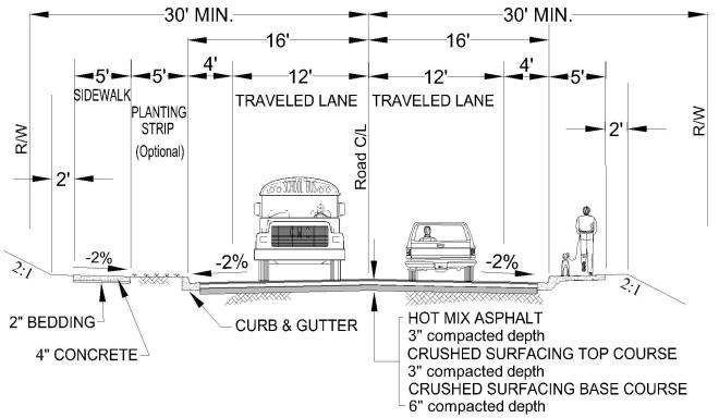
|
DESIGN SPEED (MPH) |
Table 15.30-2 |
|
MAXIMUM ROAD GRADE (Percent) |
12 |
|
MINIMUM ROAD GRADE (Percent) |
0.5 |
|
MINIMUM ROAD WIDTH (Feet) |
32 |
|
MINIMUM RIGHT-OF-WAY WIDTH (Feet) |
60* |
|
ROADWAY GEOMETRICS |
Per AASHTO and WSDOT STDS. |
* The minimum right-of-way width may be reduced from the sixty-foot standard to fifty feet with five-foot easements on each side with approval of the county engineer.
Standard Plan PW-2
Urban Local Access Class 1B
These roads serve as primary access to the development from the adjacent street system. They distribute traffic from residential neighborhoods and channel it to the collector system. There are usually no bus routes with the exception of school buses. They directly serve major traffic generators within the neighborhood, such as an elementary school or a church. They usually serve one moderate-size neighborhood or a combination of a few small developments, rather than interconnecting two or more larger neighborhoods. They serve through traffic generated from inside the neighborhood. There is direct driveway access on this class of roadway. Typical ADT may range from four hundred to one thousand five hundred vehicle trips per day.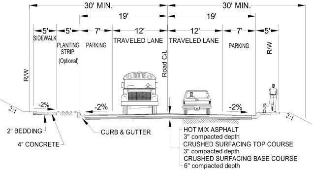
|
DESIGN SPEED (MPH) |
Table 15.30-2 |
|
MAXIMUM ROAD GRADE (Percent) |
12 |
|
MINIMUM ROAD GRADE (Percent) |
0.5 |
|
MINIMUM ROAD WIDTH (Feet) |
32 |
|
MINIMUM RIGHT-OF-WAY WIDTH (Feet) |
60* |
|
ROADWAY GEOMETRICS |
Per AASHTO and WSDOT STDS. |
* The minimum right-of-way width may be reduced from the sixty-foot standard to fifty feet with five-foot easements on each side with approval of the county engineer.
Standard Plan PW-3
Urban Local Access Class 2
These roads provide direct access from abutting land to the local access class 1 or to collectors. They are typically an internal subdivision road providing circulation within the subdivision. Service to through traffic is deliberately discouraged. Typical ADT may range from thirty to four hundred vehicle trips per day.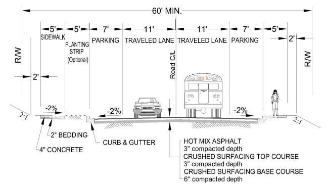
|
DESIGN SPEED (MPH) |
Table 15.30-2 |
|
MAXIMUM ROAD GRADE (Percent) |
12 |
|
MINIMUM ROAD GRADE (Percent) |
0.5 |
|
MINIMUM ROAD WIDTH (Feet) |
36 |
|
MINIMUM RIGHT-OF-WAY WIDTH (Feet) |
60* |
|
ROADWAY GEOMETRICS |
Per AASHTO and WSDOT STDS. |
* The minimum right-of-way width may be reduced from the sixty-foot standard to fifty feet with five-foot easements on each side with approval of the county engineer.
Standard Plan PW-4
Urban Local Access Class 3 Cul-de-Sac
This is an internal subdivision road with a single outlet. It serves a range of ADT of forty to one hundred twenty vehicles per day. An urban local access class 3 cul-de-sac is designed so that it can never become a road of a higher classification due to its limited expansion potential. In areas where domestic water is provided by the Chelan County PUD, looped right-of-way may be required. Cul-de-sac design may utilize alternates per PW-12.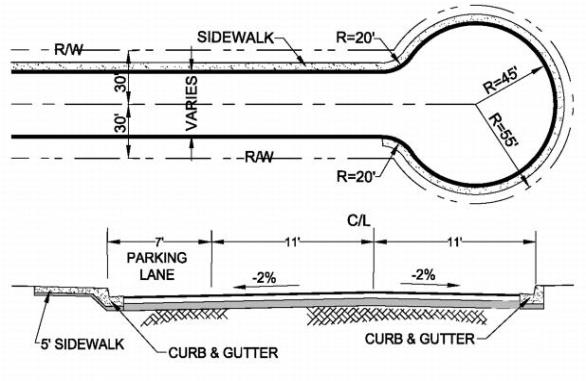
|
DESIGN SPEED (MPH) |
25 |
|
MAXIMUM ROAD GRADE (Percent) |
12* |
|
MINIMUM ROAD GRADE (Percent) |
0.5 |
|
MINIMUM ROAD WIDTH (Feet) |
29 |
|
MINIMUM RIGHT-OF-WAY WIDTH (Feet) |
60** |
|
ROADWAY GEOMETRICS |
Per AASHTO and WSDOT STDS. |
* A flatter grade of less than four percent is required in the cul-de-sac or turnaround area.
** The minimum right-of-way width may be reduced from the sixty-foot standard to fifty feet with five-foot easements on each side with approval of the county engineer.
Standard Plan PW-5
Urban Commercial/Industrial Access Road
Industrial or commercial access roads serve developments that may generate a significant proportion of truck or other heavy vehicle traffic. They may either be a public or private road. The primary function of such roads is generally to provide access from commercial or industrial land use to the local or regional highway network. Typical industrial/commercial access roads are very short, and do not serve any through traffic. Such roads are classified separately from local access roads, which they otherwise resemble, because consideration of trucks and other heavy vehicles is important in their design. Improvements such as storm drainage systems, pedestrian walkways, luminaires, and fueling stations may be incorporated in the project design.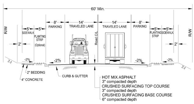
|
DESIGN SPEED (MPH) |
To be determined during design |
|
MAXIMUM ROAD GRADE (Percent) |
8 |
|
MINIMUM ROAD GRADE (Percent) |
0.5 |
|
MINIMUM ROAD WIDTH (Feet) |
44 |
|
MINIMUM RIGHT-OF-WAY WIDTH (Feet) |
80 |
|
ROADWAY GEOMETRICS |
Per AASHTO and WSDOT STDS. |
Standard Plan PW-6
Rural Collector
Rural major collectors are the main county roads in the nonurban areas. Although the predominant function of major collectors is the movement of through traffic, they also provide connections to traffic generators of intra-county importance, such as schools, shipping points, parks, important agricultural areas, etc. Collectors link these places with nearby larger towns or cities or with routes of higher classification and serve the more important intra-county travel corridors and they also provide for considerable local traffic that originates or is destined to points along the corridor. Collectors allow for more emphasis on land access than the Washington State Highway system. They usually are not located within the boundaries of identifiable neighborhood subdivisions.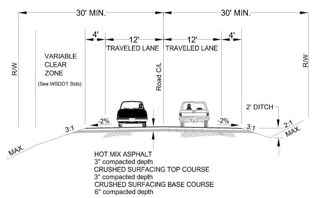
|
DESIGN SPEED (MPH) |
Table 15.30-1 |
|
MAXIMUM ROAD GRADE (Percent) |
12 |
|
MINIMUM ROAD GRADE (Percent) |
0.5 |
|
MINIMUM ROAD WIDTH (Feet) |
32 |
|
MINIMUM RIGHT-OF-WAY WIDTH (Feet) |
60 |
|
ROADWAY GEOMETRICS |
Per AASHTO and WSDOT STDS. |
|
CLEAR ZONE REQUIREMENTS |
WSDOT Design Manual Chapter 700 |
Standard Plan PW-7
Rural Local Access Class 1
Serves as primary access to the development from the adjacent street system. It distributes traffic from residential neighborhoods and channels it to the collector system. It typically does not service any major traffic generators within the neighborhood, such as an elementary school or a church. It usually serves one moderate-size neighborhood or a combination of a few small developments, rather than interconnecting two or more larger neighborhoods. It serves little, if any, through traffic generated outside the neighborhood. Typical ADT may range from four hundred to one thousand five hundred vehicle trips per day. Abutting residences are oriented away from the rural local access class 1 road.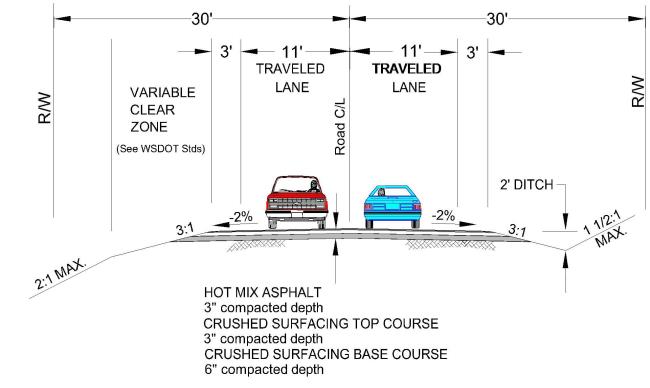
|
DESIGN SPEED (MPH) |
Table 15.30-2 |
|
MAXIMUM ROAD GRADE (Percent) |
12 |
|
MINIMUM ROAD GRADE (Percent) |
0.5 |
|
MINIMUM ROAD WIDTH (Feet) |
28 |
|
MINIMUM RIGHT-OF-WAY WIDTH (Feet) |
60* |
|
ROADWAY GEOMETRICS |
Per AASHTO and WSDOT STDS. |
|
CLEAR ZONE REQUIREMENTS |
WSDOT Design Manual Chapter 700 |
* The minimum right-of-way width may be reduced from the sixty-foot standard to fifty feet with five-foot easements on each side with approval of the county engineer.
Standard Plan PW-8
Rural Local Access Class 2
Provides direct access from abutting land to higher classified local access roads or the collector system. They are typically an internal subdivision road providing circulation within the subdivision. Service to through traffic is deliberately discouraged. ADTs range from thirty to four hundred vehicle trips per day.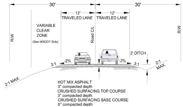
|
DESIGN SPEED (MPH) |
Table 15.30-2 |
|
MAXIMUM ROAD GRADE (Percent) |
12 |
|
MINIMUM ROAD GRADE (Percent) |
0.5 |
|
MINIMUM ROAD WIDTH (Feet) |
24 |
|
MINIMUM RIGHT-OF-WAY WIDTH (Feet) |
60* |
|
ROADWAY GEOMETRICS |
Per AASHTO and WSDOT STDS. |
|
CLEAR ZONE REQUIREMENTS |
WSDOT Design Manual Chapter 700 |
* The minimum right-of-way width may be reduced from the sixty-foot standard to fifty feet with five-foot easements on each side with approval of the county engineer.
Standard Plan PW-9
Rural Local Access Class 3 Cul-de-Sac
An internal subdivision road that may have single outlet. Direct lot access is provided this classification. It serves a typical ADT range of forty to one hundred twenty vehicles per day or less. Potential for future road extension will require design to rural local access class 2 standards. This class of roadway is required to provide a cul-de-sac as shown on Standard Plan PW-12.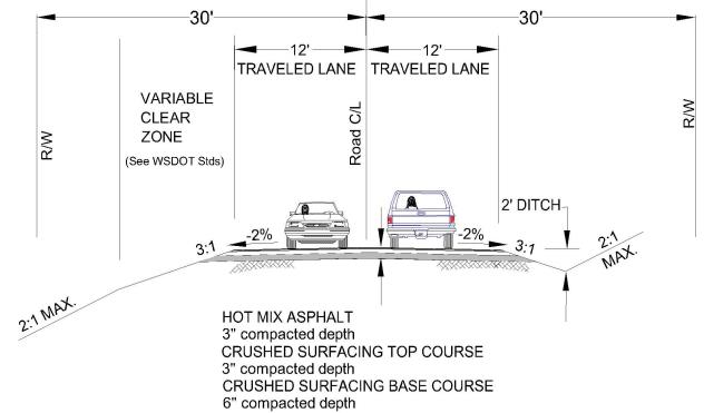
|
DESIGN SPEED (MPH) |
Table 15.30-2 |
|
MAXIMUM ROAD GRADE (Percent) |
12* |
|
MINIMUM ROAD GRADE (Percent) |
0.5 |
|
MINIMUM ROAD WIDTH (Feet) |
24 |
|
MINIMUM RIGHT-OF-WAY WIDTH (Feet) |
60** |
|
ROADWAY GEOMETRICS |
Per AASHTO and WSDOT STDS. |
* A flatter grade of less than four percent is required in the cul-de-sac or turnaround area.
** The minimum right-of-way width may be reduced from the sixty-foot standard to fifty feet with five-foot easements on each side with approval of the county engineer.
Standard Plan PW-10
Rural Local Access Class HD
Land applications that utilize smaller urban sized lots outside of the UGA (rural areas) such as LAMIRDs may utilize the rural local access class HD road standard. This standard needs to incorporate parking and pedestrian facilities consistent with the urban road functions, but retain a rural character. The function of sidewalks and on-street parking may be met through the use of paths and off-site parking. Drainage may still be accomplished through the use of ditches although underground systems may be required for the economical use of the smaller lot size.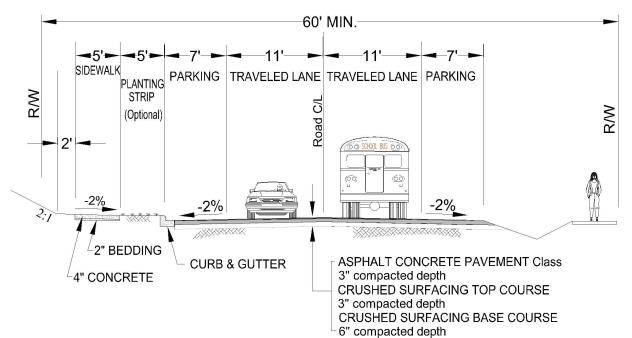
|
DESIGN SPEED (MPH) |
Table 15.30-2 |
|
MAXIMUM ROAD GRADE (Percent) |
12 |
|
MINIMUM ROAD GRADE (Percent) |
0.5 |
|
MINIMUM ROAD WIDTH (Feet) |
36 |
|
MINIMUM RIGHT-OF-WAY WIDTH (Feet) |
60* |
|
ROADWAY GEOMETRICS |
Per AASHTO and WSDOT STDS. |
* The minimum right-of-way width may be reduced from the sixty-foot standard to fifty feet with five-foot easements on each side with approval of the county engineer.
Standard Plan PW-11
Standard Cul-de-Sac
Minimum right-of-way radius across bulb section: fifty-five feet from the central point in a permanent cul-de-sac.
Providing a snow storage easement and the design of adjacent lot line driveways may be required.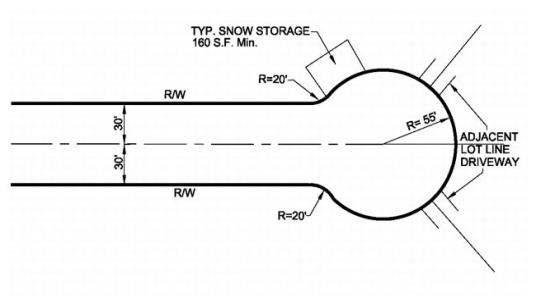
Alternate Configuration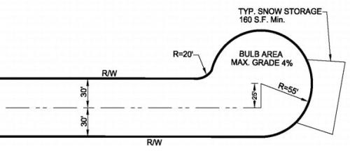
Standard Plan PW-12
Temporary Cul-de-Sac
A temporary cul-de-sac shall be provided when there is a foreseeable likelihood of extending the road to adjacent properties, or as part of a subdivision phasing plan. Right-of-way shall be thirty feet each side from the centerline, with the bulb area lying outside the road right-of-way provided as a temporary easement pending forward extension of the road. Surfacing, curb and gutter requirements shall be as required for typical roadway section for the road classification. Removal of the temporary cul-de-sac and installation of permanent curb, gutter and sidewalks shall be the responsibility of the developer who extends the road.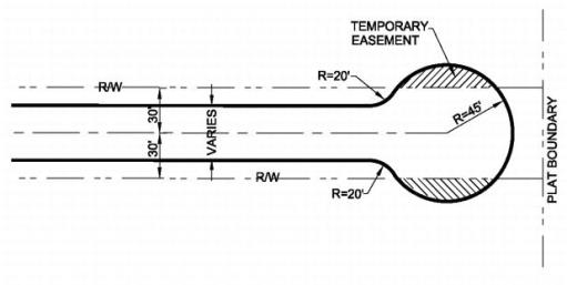
Standard Plan PW-13
Rural Commercial/Industrial Access Road
Industrial or commercial access roads serve developments that may generate a significant proportion of truck or other heavy vehicle traffic. They may either be a public or private road. The primary function of such roads is generally to provide access from commercial or industrial land use to the local or regional highway network. Typical industrial/commercial access roads are very short, and do not serve any through traffic. Such roads are classified separately from local access roads, which they otherwise resemble, because consideration of trucks and other heavy vehicles is important in their design. Improvements such as storm drainage systems, pedestrian walkways, luminaires, and fueling stations may be incorporated in the project design.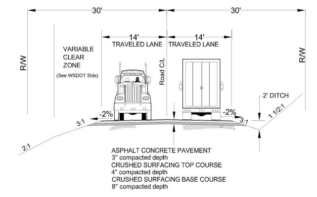
|
DESIGN SPEED (MPH) |
To be determined during design |
|
MAXIMUM ROAD GRADE (Percent) |
8 |
|
MINIMUM ROAD GRADE (Percent) |
0.5 |
|
MINIMUM ROAD WIDTH (Feet) |
28 |
|
MINIMUM RIGHT-OF-WAY WIDTH (Feet) |
60 |
|
ROADWAY GEOMETRICS |
Per AASHTO and WSDOT STDS. |
Standard Plan PW-14
Private Urban Local Access Class 1A
This class of roadway typically provides direct access from subdivisions to the collector system. They are typically an internal access road providing circulation within the subdivision. ADTs range from four hundred to one thousand five hundred vehicle trips per day. This standard is used when there is no direct driveway access onto the roadway.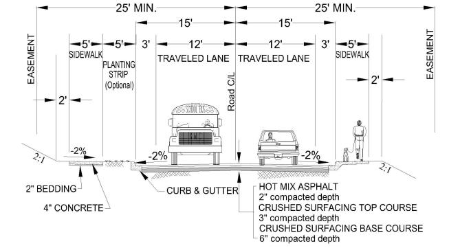
|
DESIGN SPEED (MPH) |
25 |
|
MAXIMUM ROAD GRADE (Percent) |
12 |
|
MINIMUM ROAD GRADE (Percent) |
0.5 |
|
MINIMUM ROAD WIDTH (Feet) |
30 |
|
MINIMUM RIGHT-OF-WAY WIDTH (Feet) |
50 |
|
ROADWAY GEOMETRICS |
Per AASHTO and WSDOT STDS. |
Standard Plan PW-15
Private Urban Local Access Class 1B
This class of roadway typically provides direct access from subdivisions to the collector system. They are typically an internal access road providing circulation within the subdivision. ADTs range from four hundred to one thousand five hundred vehicle trips per day. This standard provides for on-street parking due to lots having direct driveway access.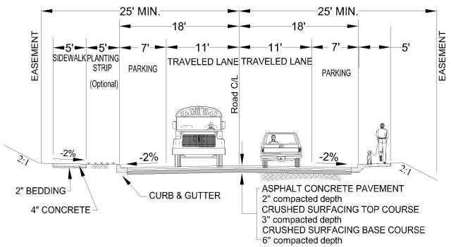
|
DESIGN SPEED (MPH) |
25 |
|
MAXIMUM ROAD GRADE (Percent) |
12 |
|
MINIMUM ROAD GRADE (Percent) |
0.5 |
|
MINIMUM ROAD WIDTH (Feet) |
36 |
|
MINIMUM RIGHT-OF-WAY WIDTH (Feet) |
50 |
|
ROADWAY GEOMETRICS |
Per AASHTO and WSDOT STDS. |
Standard Plan PW-16
Private Urban Local Access Class 2
This class of roadway typically provides direct access from subdivisions to higher classified local access roads or to the collector system. They are typically an internal access road providing circulation within the subdivision. ADTs range from one hundred twenty to four hundred vehicle trips per day.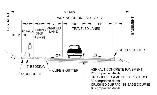
|
DESIGN SPEED (MPH) |
25 |
|
MAXIMUM ROAD GRADE (Percent) |
12 |
|
MINIMUM ROAD GRADE (Percent) |
0.5 |
|
MINIMUM ROAD WIDTH (Feet) |
28 |
|
MINIMUM RIGHT-OF-WAY WIDTH (Feet) |
50 |
|
ROADWAY GEOMETRICS |
Per AASHTO and WSDOT STDS. |
Standard Plan PW-17
Urban Emergency Vehicle Access Road
This class of roadway is a private road serving three to twelve lots. The requirements for a urban emergency vehicle access road (EVAR) will provide off-site parking if they serve lots less than fourteen thousand square feet.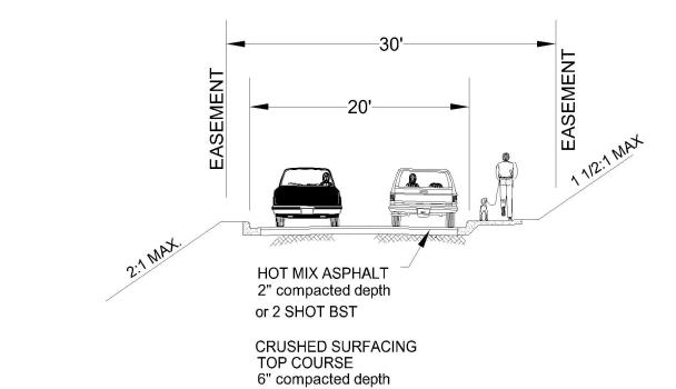
|
DESIGN SPEED (MPH) |
25 |
|
MAXIMUM ROAD GRADE (Percent) |
12 |
|
MINIMUM ROAD GRADE (Percent) |
0.5 |
|
MINIMUM ROAD WIDTH (Feet) |
20 |
|
MINIMUM RIGHT-OF-WAY WIDTH (Feet) |
30 |
Dead-end roads that exceed one hundred fifty feet in length shall provide an emergency vehicle turnaround in accordance with Standard Plan PW-23-A or PW-23-B.
Standard Plan PW-18
Private Rural Local Access Class 1
Is an internal subdivision road which may also be a single outlet with a cul-de-sac in accordance with Standard Plan PW-12. It serves an ADT range of four hundred to one thousand five hundred.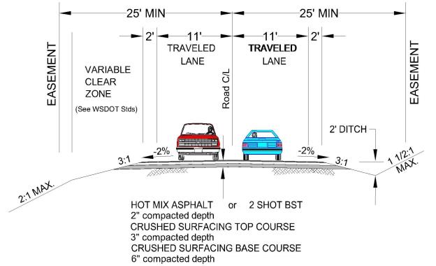
|
DESIGN SPEED (MPH) |
25 |
|
MAXIMUM ROAD GRADE (Percent) |
12 |
|
MINIMUM ROAD GRADE (Percent) |
0.5 |
|
MINIMUM ROAD WIDTH (Feet) |
26 |
|
MINIMUM RIGHT-OF-WAY WIDTH (Feet) |
50 |
|
ROADWAY GEOMETRICS |
Per AASHTO and WSDOT STDS. |
Standard Plan PW-19
Private Rural Local Access Class 2
This class of roadway is an internal subdivision road. It serves as access to up to forty residences and has an ADT of one hundred twenty up to four hundred vehicles per day or less.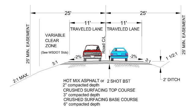
|
DESIGN SPEED (MPH) |
25 |
|
MAXIMUM ROAD GRADE (Percent) |
12 |
|
MINIMUM ROAD GRADE (Percent) |
0.5 |
|
MINIMUM ROAD WIDTH (Feet) |
22 |
|
MINIMUM EASEMENT WIDTH (Feet) |
50 |
|
ROADWAY GEOMETRICS |
Per AASHTO and WSDOT STDS. |
Standard Plan PW-20
Private Rural Local Access Class HD
Land applications that utilize smaller urban-sized lots outside of the UGA (rural areas) such as LAMIRDs may utilize the rural local access class HD road standard. This standard needs to incorporate parking and pedestrian facilities consistent with the urban road functions, but retain a rural character. The function of sidewalks and on-street parking may be met through the use of paths and off-site parking. Drainage may still be accomplished through the use of ditches although underground systems may be required for the economical use of the smaller lot size.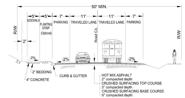
|
DESIGN SPEED (MPH) |
Table 15.30-2 |
|
MAXIMUM ROAD GRADE (Percent) |
12 |
|
MINIMUM ROAD GRADE (Percent) |
0.5 |
|
MINIMUM ROAD WIDTH (Feet) |
36 |
|
MINIMUM RIGHT-OF-WAY WIDTH (Feet) |
50 |
|
ROADWAY GEOMETRICS |
Per AASHTO and WSDOT STDS. |
Standard Plan PW-21
Rural Emergency Vehicle Access Road
This class of roadway is a private road serving three to twelve lots. The requirements for a rural emergency vehicle access road (EVAR) will not provide off-site parking.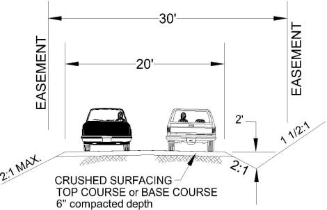
|
DESIGN SPEED (MPH) |
25 |
|
MAXIMUM ROAD GRADE (Percent) |
12 |
|
MINIMUM ROAD GRADE (Percent) |
0.5 |
|
MINIMUM ROAD WIDTH (Feet) |
20 |
|
MINIMUM EASEMENT WIDTH (Feet) |
30 |
Dead-end roads that exceed one hundred fifty feet in length shall provide an emergency vehicle turnaround in accordance with Standard Plan PW-23-A and PW-23-B.
Standard Plan PW-22
Urban/Rural Emergency Vehicle Access Road Turnarounds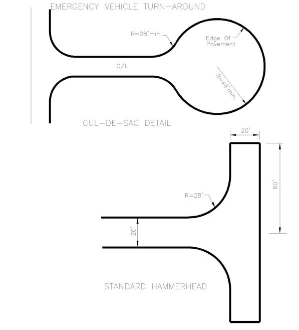
Dead-end roads that exceed one hundred fifty feet shall provide an emergency vehicle turnaround.
Standard Plan PW-23-A
Urban/Rural Emergency Vehicle Access Road Turnarounds (Continued)
Dead-end roads that exceed one hundred fifty feet shall provide an emergency vehicle turnaround.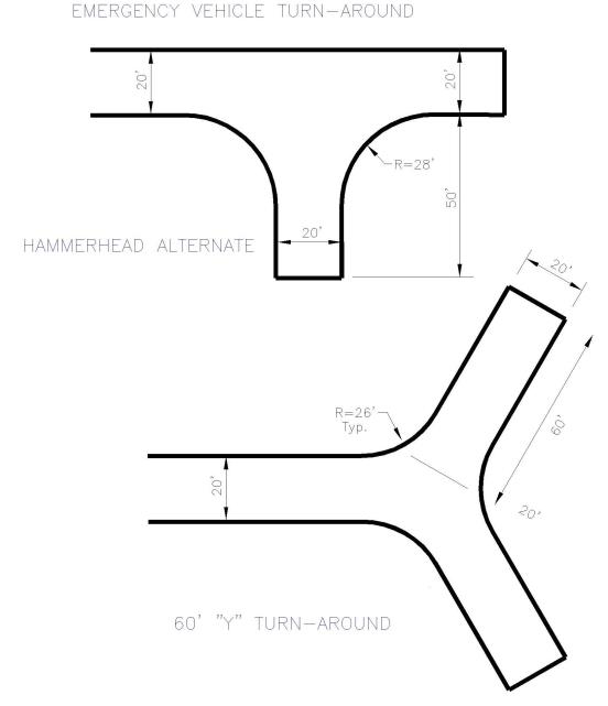
Standard Plan PW-23-B
Sight Triangles
(1) At any intersection of a private road/access point with a county road, there must be a sight distance triangle which provides an unobstructed line of sight from a point ten feet behind the edge of traveled way (point A) to a point in the traveled way (point B) at least equal to the required sight distance.
(2) The driver’s eye to determine line of sight at intersections is three feet, six inches above the pavement, with an object height of four feet, three inches above the pavement.
(3) The edge of traveled way is defined as the face of curb for roads that are or will be constructed to urban standards and the painted fog line or the edge of pavement (not shoulder) for roads that are or will be constructed to rural standards. The area within the sight distance triangle must be free from any sight-obscuring objects.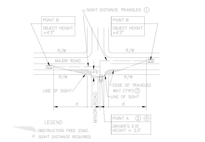
Standard Plan PW-24
Rural and Urban Residential Driveway Approach
Residential driveway approaches shall be constructed the maximum practical distance, but in no event, less than one hundred twenty-five feet from a collector or local access road intersection; or less than seventy-five feet from a local access road or cul-de-sac intersection. Residential driveway approaches shall not be spaced closer than seventy feet, measured centerline to centerline.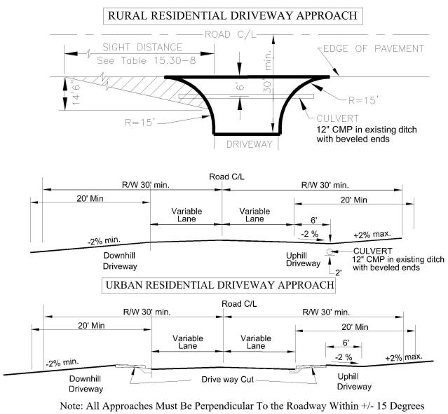
Standard Plan PW-25
Industrial/Commercial Driveway Approach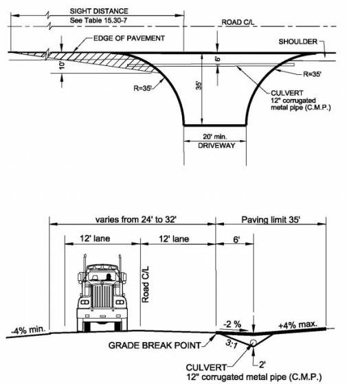
Standard Plan PW-26
Temporary Construction Approach
Temporary construction approaches shall be used any time access from a construction site to a county road is necessary. Design criteria for a commercial approach shall be used. The adjacent county road shall be kept clean. Roads shall be swept, not washed. All sediment collected by sweeping shall be stabilized on site. Washing the road into the storm system will not be permitted.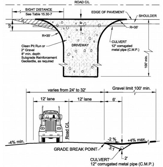
Standard Plan PW-27
Rock Facing Cut Section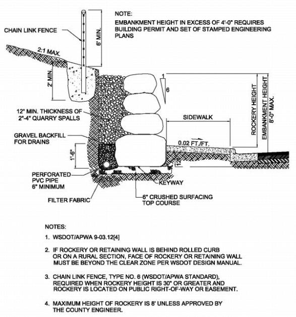
Standard Plan PW-28
Rock Facing Fill Section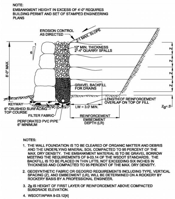
Standard Plan PW-29
Centralized Mail Delivery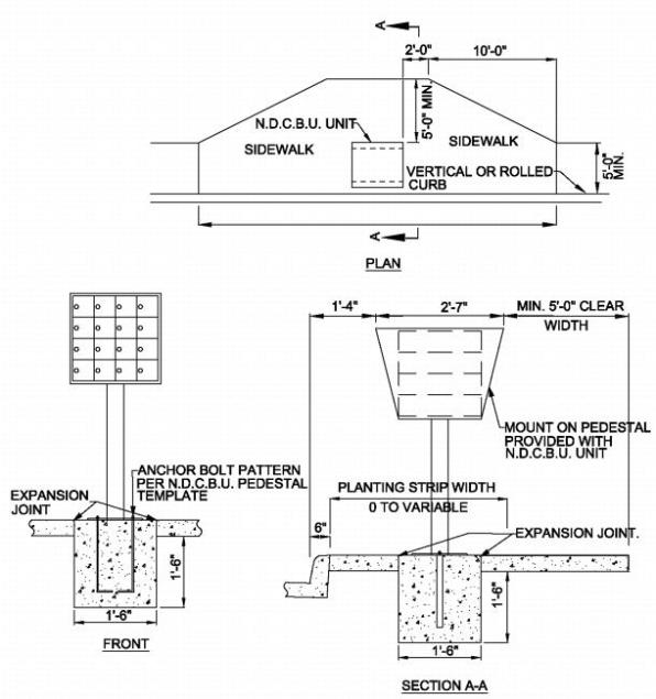
Standard Plan PW-30
Curb and Gutter Detail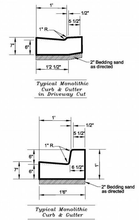
Standard Plan PW-31
Driveway Approach Details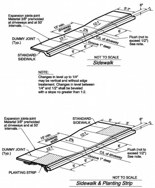
Standard Plan PW-32
Curb, Gutter, Sidewalk and Planting Strip Detail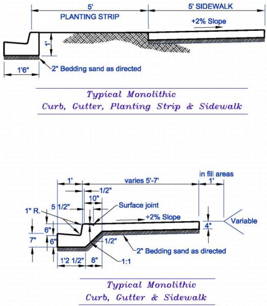
Standard Plan PW-33
(Res. 2008-130 (part), 8/26/08)
Appendix B DESIGN DEVIATIONS
Authorization
The county engineer is authorized to grant design deviations from the requirements of Title 15.
Applicability
(1) The Title 15 road standards represent reasonable approaches based on past experience in Chelan County and other jurisdictions. These standards indicate the appropriate practice under most conditions.
(2) Engineering design is an endeavor that examines alternative solutions to real world situations and accordingly these standards are not provided to hamper the introduction of new ideas. It is fully expected that creative engineering will continue to take place. Situations will present themselves where deviations may be preferred to allow conformance with existing conditions, to overcome adverse topography or to allow for more affordable solutions without adversely affecting safety, function, appearance, emergency vehicle response, and maintainability. These standards are intended to provide predictability yet still allow for the flexibility necessary for innovation.
(3) Design deviations to these standards may be proposed at the pre-application meeting and evaluated and acted upon prior to the application submittal. Except as indicated in subsections (4) or (5)(D) of this appendix, all deviations shall be approved prior to the issue of the permit, administrative decision, or prior to hearing.
(4) After the issue of the original permit, administrative decision, or hearing, deviations may be requested for unforeseen circumstances based on conditions of approval. If granted approval, the modified application shall go through re-issuing of the permit, administrative review, or hearing.
(5) The design deviation request shall be in writing, submitted to the county engineer, and address the following points:
(A) Specifically outline the reason for the alternative request.
(B) Specify the chapter and section the alternative request is for.
(C) Provide supporting evidence demonstrating that a deviation from these standards is based on sound engineering judgment that the requirements for safety, function, appearance, emergency vehicle response, and maintainability are fully met and complies with the Chelan County comprehensive plan.
(D) Under extreme circumstances, a request for a deviation during construction may be requested for change of conditions. The request shall be for unforeseen site conditions by the applicant, as agreed to by the county engineer. Request for deviations made during the construction of a project shall be approved by the county engineer prior to any changes being made in the field.
Consideration and Action
Design deviations from the standards in this title will be considered on a case-by-case basis.
Design deviation requests may be approved outright by the county engineer.
Design deviation requests not outright approved by the county engineer may request a review and reconsideration of the denial. The design review panel will review the deviation request and make a recommendation to the county engineer. The county engineer will then consider the recommendation of the design review panel and render a final decision on the deviation request. In the event that the panel is unanimous in its recommendation, its recommendation will be the final decision.
The design review panel shall be selected by the county engineer and consist of four professional engineers, two from public service and two from the private sector, not involved in the initial review.
The applicant shall reimburse the county for all costs incurred for the deviation review in accordance with the latest fee schedule adopted by the board of county commissioners.
Expiration
An approved design deviation request shall be valid for the life of a project consistent with Chapter 15.30.
(Res. 2019-35, 3/12/2019: Res. 2008-130 (part), 8/26/08).


