


Chapter 16.08
CRITICAL AREAS
Sections:
Article I. Introduction
16.08.040 Relationship to other regulations.
Article II. General Provisions
16.08.050 Applicability and jurisdiction.
16.08.070 Authorizations required.
16.08.080 Administrative procedures.
16.08.090 Exemption from critical area review requirements.
16.08.100 Waiver for subsequent approvals.
16.08.120 Reasonable use procedures.
16.08.170 Offense and penalty.
Article III. Critical Area Review
16.08.180 Critical area review requirements.
16.08.200 Critical areas determination.
16.08.220 Completion of critical area review.
Article IV. Critical Area Mitigation Requirements
16.08.230 Critical area mitigation.
16.08.240 Performance and maintenance securities.
Article V. Wetlands
16.08.250 Wetland designation.
16.08.260 Wetland rating (categorization) and functional assessment.
16.08.270 Wetland technical report requirements.
16.08.290 Stormwater management implications to wetlands and wetland buffers.
16.08.300 Wetland buffer requirements.
16.08.310 Wetland mitigation requirements.
16.08.320 Alternative or innovative mitigation plans.
16.08.340 Use of bank credits.
16.08.350 In-lieu fee mitigation.
16.08.360 Watershed-based management plans.
Article VI. Fish and Wildlife Habitat Conservation Areas
16.08.370 Fish and wildlife habitat conservation areas designation.
16.08.380 Fish and wildlife habitat conservation areas classification.
16.08.390 Fish and wildlife habitat conservation areas indicators.
16.08.400 Fish and wildlife habitat conservation areas buffers.
16.08.410 Fish and wildlife habitat conservation areas technical report.
Article VII. Geologically Hazardous Areas
16.08.420 Geologically hazardous areas designation.
16.08.430 Geologically hazardous areas classification.
16.08.440 Geologically hazardous areas indicators.
16.08.450 Geologically hazardous areas performance requirements.
Article VIII. Critical Aquifer Recharge Areas
16.08.460 Critical aquifer recharge area designation.
16.08.470 Exempted and prohibited uses.
16.08.480 Wellhead protection areas – Existing uses.
16.08.490 Aquifer recharge area technical report requirements.
16.08.500 Aquifer recharge area performance requirements.
Article IX. Flood Hazard Areas
16.08.510 Flood hazard areas designation.
16.08.520 Flood hazard areas performance requirements.
Article X. Definitions
Article XI. Appendix A
Article XII. Appendix B
Article I. Introduction
16.08.010 Purpose and intent.
A. The intent of this chapter is to identify and define the types and qualities of various critical areas within the Ferndale community that contribute to or affect public health, safety and general welfare; and to protect those critical areas deemed important by the citizens of Ferndale, the state of Washington, and/or the federal government using best available science. Critical areas addressed in this chapter include:
1. Wetlands;
2. Geologically hazardous areas;
3. Fish and wildlife habitat conservation areas;
4. Aquifer recharge areas; and
5. Frequently flooded areas.
B. The purpose of this chapter is to provide understandable and reasonable requirements for the use and development of land within or in proximity to critical areas. The requirements set forth herein are adopted in order to:
1. Minimize development impacts to protect the beneficial uses and ensure no-net-loss of ecological functions and values of critical areas;
2. Protect the quality and quantity of all natural water resources and the native species inhabiting local waterways, wetlands, and habitats;
3. Prevent erosion and loss of slope and soil stability caused by removal of trees, shrubs, root systems of vegetative cover, or alteration of ground and surface movement;
4. Protect the public against potentially avoidable losses from landslide, subsidence, erosion and flooding;
5. Meet the requirements of the Washington Growth Management Act (Chapter 36.70A RCW) with respect to the protection of critical areas; and
6. Identify opportunities for the creation of new or the enhancement or repair of existing critical areas within the City of Ferndale and watersheds associated with the City of Ferndale. Said opportunities include, but are not limited to, the establishment of a mitigation bank, an in-lieu-fee program, or similar programs. (Ord. 1987 § 1 (Exh. 1), 2017; Ord. 1398 § 2, 2006)
16.08.020 Authority.
This chapter is adopted under the authority of Chapter 36.70 RCW, Planning Enabling Act; Chapter 36.70A RCW, Growth Management – Planning by Selected Counties and Cities; and Article 11, County, City and Township Organization, of the Washington State Constitution. (Ord. 1987 § 1 (Exh. 1), 2017; Ord. 1398 § 2, 2006)
16.08.030 Interpretation.
In the interpretation and application of this chapter, all provisions shall be considered to be the minimum necessary and shall be liberally construed to serve the purposes of this chapter. (Ord. 1987 § 1 (Exh. 1), 2017; Ord. 1398 § 2, 2006)
16.08.040 Relationship to other regulations.
A. The regulations contained in this chapter shall apply as an overlay to other regulations established by the City. In the event of any conflict between these regulations and any other regulations, the more restrictive shall apply.
B. Regulation of frequently flooded areas as required by Chapter 36.70A RCW and Chapter 365-190 WAC is provided through the floodplain management ordinance of the City of Ferndale, Chapter 15.24 FMC.
C. Compliance with the provisions of this chapter does not constitute compliance with other federal, state, and local regulations and permit requirements that may be required (for example, shoreline substantial development permits, HPA permits, Army Corps of Engineers Section 404 permits, NPDES permits). The applicant is responsible for complying with these requirements, apart from the process established in this chapter.
D. These regulations are in addition to, and coordinate with, the Ferndale Comprehensive Plan, the Ferndale shoreline master program, and other applicable regulations adopted by the City of Ferndale. (Ord. 1987 § 1 (Exh. 1), 2017; Ord. 1398 § 2, 2006)
Article II. General Provisions
16.08.050 Applicability and jurisdiction.
This chapter shall apply to all land, all land uses and development, and all structures and facilities within the City of Ferndale, except as specifically exempted under FMC 16.08.090. (Ord. 1987 § 1 (Exh. 1), 2017; Ord. 1398 § 2, 2006)
16.08.060 Critical area maps.
A. In conjunction with the adoption of this chapter, the City Council shall adopt maps indicating the locations of known or potential critical areas within the City of Ferndale. Maps generated by resource agencies are listed in Appendix B of this chapter. These maps are and/or shall be based on the best available scientific information and shall include natural resource information gathered through field inventory, as well as information prepared by applicable state and federal natural resource agencies, and previously approved critical areas studies. These maps shall be hereafter referred to as the “critical area maps” of the City of Ferndale.
B. The Critical Areas Administrator or designee shall update the critical area maps periodically to reflect new information and shall make the maps available to the public upon request.
C. The critical area maps shall be utilized as a source of generalized information and shall not be a substitute for site-specific assessments. The actual type, extent and boundaries of critical areas (with the exception of frequently flooded areas) shall be determined by a qualified consultant on a site-specific basis according to the provisions established in this chapter.
D. These maps and resources listed in Appendix B of this chapter are to be used as a reference for the City, project applicants, and/or property owners as qualitative guidance. Said maps do not constitute either the presence or absence of critical areas, therefore, at the discretion of the Critical Areas Administrator, a critical areas report may be required. These maps shall be periodically updated as new critical areas are identified. They are a reference and do not provide a final critical area location, designation, classification, category, and/or buffers. (Ord. 1987 § 1 (Exh. 1), 2017; Ord. 1398 § 2, 2006)
16.08.070 Authorizations required.
A. No development activity or alteration of land, water or vegetation within a critical area or its standard buffer, except as specifically allowed under FMC 16.08.090, shall be allowed without prior authorization from the Critical Areas Administrator or designee.
B. The City of Ferndale shall ensure that the provisions of this chapter are met in conjunction with review of applications for the following permits and approvals:
1. Building permit;
2. Conditional use permit;
3. Land disturbance permit (clearing or grading);
4. SEPA determination;
5. Shoreline conditional use permit;
6. Shoreline substantial development permit;
7. Shoreline variance;
8. Short plat;
9. Site plan review;
10. Long plat;
11. Zoning variance;
12. Binding site plan;
13. Planned unit development; or
14. Any other permit or approval required by the Ferndale Municipal Code, as amended, not expressly exempted by this chapter. (Ord. 1987 § 1 (Exh. 1), 2017; Ord. 1398 § 2, 2006)
16.08.080 Administrative procedures.
The administrative procedures followed during the critical area review process shall conform to the standards and requirements of the City of Ferndale development regulations. This shall include, but not be limited to, timing, appeals, and fees associated with applications covered by this chapter. (Ord. 1987 § 1 (Exh. 1), 2017; Ord. 1398 § 2, 2006)
16.08.090 Exemption from critical area review requirements.
The Critical Areas Administrator has the authority to determine whether any development activity is exempt from the provisions outlined below.
A. Subject to the limitations established in subsections (B), (C), (D) and (E) of this section, the following developments, associated uses and activities shall be exempt from the critical area review procedures established in this chapter:
1. Emergency activities necessary to reduce or prevent an immediate threat to public health, safety and welfare. An emergency is an unanticipated and imminent threat to the public health or safety or to the environment that requires immediate action within a period of time too short to allow full compliance with this chapter. The person or agency undertaking such emergency action shall notify the Critical Areas Administrator within one working day or as soon as practical following commencement of the emergency activity.
Following such notification, the Critical Areas Administrator shall determine if the action taken was within the scope of the emergency actions allowed in this subsection. If the Critical Areas Administrator determines that the action taken or any part of the action taken was beyond the scope of allowed emergency actions, then the enforcement provisions of FMC 16.08.160 shall apply. The exemption for emergencies should not eliminate the need for later mitigation to offset the impacts of emergency activity. Once the immediate threat has been addressed, any adverse impacts on critical areas shall be mitigated, as determined by the Critical Areas Administrator.
2. Ongoing agriculture activities, including related development and activities that do not result in expansion into a critical area or its standard buffer.
3. Normal and routine maintenance or repair of existing structures, utilities, sewage disposal systems, potable water systems, drainage facilities, ponds, or public and private roads and driveways associated with existing residential or commercial development; normal maintenance, repair, or operation of existing structures, facilities, and improved areas accessory to a single-family residential use; and maintenance activities such as mowing and normal pruning; provided, that such maintenance activities are limited to existing landscaping improvements and do not expand into critical areas or associated buffers, do not expose soils, do not alter topography, do not destroy or clear native vegetation, and do not diminish water quality or quantity. Destruction or clearing of native vegetation in critical areas, their buffers, or steep slopes is prohibited.
4. Modification of any existing residence that does not add to or alter the existing use and does not expand the building footprint or increase septic effluent.
5. Activities involving artificially created wetlands or artificial watercourses intentionally created from nonwetland sites, including, but not limited to, activities incidental to construction, grass-lined swales, irrigation and drainage ditches, road side ditches, stormwater detention facilities, and landscape features. It is incumbent upon the applicant to adequately document and demonstrate said features were created from nonwetland sites. This exemption does not include those features that provide critical habitat for federal and state protected species, species of local importance, or for anadromous fish and those features which were created as mitigation pursuant to the provisions of this chapter.
6. Passive outdoor recreational activities, such as low impact trails and bird watching that do not adversely impact critical areas or their buffers.
7. The harvesting of wild crops in a manner that is not injurious to natural reproduction of such crops and provided the harvesting does not require tilling soil, planting crops, or changing existing topography, water conditions, water quality, or water sources.
8. The lawful operation and maintenance of public and private diking and drainage systems established in compliance with the City of Ferndale stormwater regulations and which have been maintained in good condition that protect life and property.
9. Education and scientific research activities that do not adversely impact critical areas or their buffers.
10. Site investigation work necessary for land use applications such as surveys, soil logs, percolation tests and other related activities that do not adversely impact critical areas or their buffers. In every case, critical area impacts shall be minimized and disturbed areas shall be immediately restored to the predisturbance condition.
11. Fish, wildlife, wetland and/or riparian enhancement activities not required as mitigation; provided, that the project is approved by the U.S. Department of Fish and Wildlife (USFWS), the National Oceanic and Atmospheric Administration Fisheries (NOAA Fisheries), the U.S. Army Corps of Engineers (USCOE), the Washington State Department of Fish and Wildlife (WDFW), the Washington State Department of Ecology (Ecology), or any other state or federal regulatory agency.
B. Exemption from critical areas review shall not constitute exemption from any other applicable provision of the Ferndale Municipal Code or those other regulations described in FMC 16.08.040.
C. Exempt activities shall use reasonable methods or accepted best management practices to reduce potential impacts to critical areas and/or to restore impacted critical areas to the extent feasible following completion of exempt activities as determined by the Critical Areas Administrator. Exemption does not give permission to destroy a critical area or buffer or to ignore risk from a natural hazard.
D. The Critical Areas Administrator is hereby authorized to grant or deny requests for statements of exemption from the critical areas review for activities within critical areas which are specifically listed in subsection (A) of this section. The statement by an applicant shall be in writing and shall indicate the specific exemption from this section that is being applied to the development. The statement shall also provide a summary of the Critical Areas Administrator’s analysis of the consistency of an activity with the critical areas ordinance. A denial by the Critical Areas Administrator of an exemption shall be in writing and shall identify the reason(s) for the denial. The Critical Areas Administrator’s actions on the issuance of a statement of exemption or a denial are subject to appeal pursuant to FMC 14.11.070.
E. The Critical Areas Administrator shall make written findings of fact setting forth the exact parameters of the exempted development, any conditions attached in conjunction with subsection (C) of this section, and supporting the exemption determination citing the criteria used and conclusions reached.
F. If a nondevelopment activity (not otherwise requiring a development permit or approval) is determined to be exempt under subsection (A) of this section and adheres to the requirements established under subsection (C) of this section, then critical area review shall not be required and the activity may proceed. (Ord. 1987 § 1 (Exh. 1), 2017; Ord. 1398 § 2, 2006)
16.08.100 Waiver for subsequent approvals.
Critical area review requirements may be waived by the Critical Areas Administrator in conjunction with review of a building permit application when all of the following conditions are met:
A. The provisions of this chapter have been addressed fully through previous critical areas review of a development approval (such as a subdivision, conditional use or other permit identified under FMC 16.08.070(B));
B. The subsequent construction activity complies fully with the conditions established as part of the initial land use approval; and
C. No substantial changes in the nature or extent of the approved activity have been made. (Ord. 1987 § 1 (Exh. 1), 2017; Ord. 1398 § 2, 2006)
16.08.110 Reasonable use.
A. Permit applicants with a property so encumbered by critical areas and/or buffers, where avoidance of direct or indirect impacts by a proposed project is impossible or impractical, and that application of this chapter, including buffer averaging, buffer reduction, or other mechanism, would deny all reasonable use, may seek approval pursuant to the reasonable use standards and procedures provided in this section.
B. Reasonable Use Standards.
1. To qualify as a reasonable use, the Critical Areas Administrator or Hearings Examiner, as appropriate, must find that the proposal is consistent with all of the following criteria:
a. There is no portion of the site where the provisions of this chapter allow reasonable economic use, including agricultural use or continuation of legal nonconforming uses;
b. There is no feasible alternative to the proposed activities that will provide reasonable economic use with less adverse impact on critical areas and/or buffers. Feasible alternatives may include, but are not limited to, locating the activity on a contiguous parcel that has been under the ownership or control of the applicant since the effective date of the ordinance codified in this chapter, change in use, reduction in size, change in timing of activity, and/or revision of project design;
c. Activities will be located as far as possible from critical areas and the project employs all reasonable methods to avoid adverse effects on critical area functions and values, including maintaining existing vegetation, topography, and hydrology. Where both critical areas and buffer areas are located on a parcel, buffer areas shall be disturbed in preference to the critical area;
d. The proposed activities will not result in adverse effects on endangered or threatened species as listed by the federal government or the state of Washington, or be inconsistent with an adopted recovery plan;
e. Measures shall be taken to ensure the proposed activities will not cause degradation of groundwater or surface water quality, or adversely affect drinking water supply;
f. The proposed activities comply with all state, local and federal laws, including those related to erosion and sediment control, pollution control, floodplain restrictions, and on-site wastewater disposal;
g. The proposed activities will not cause damage to other properties;
h. The proposed activities will not increase risk to the health or safety of people on or off the site;
i. The inability to derive reasonable economic use of the property is not a result of segregating or dividing the property and/or creating the condition of lack of use after the effective date of the ordinance codified in this chapter;
j. For single-family residences, the maximum impact area shall be no larger than 3,500 square feet. This impact area shall include the residential structure as well as appurtenant development that are necessarily connected to the use and enjoyment of a single-family residence. The appurtenant developments include garages, decks, driveways, parking, utilities, and all landscaping, with the following exceptions:
i. On lots outside of the shoreline jurisdiction, when an extended driveway is necessary to access a portion of a development site with the least impact on critical area and/or buffers, those portions of the driveway shall be excluded from the 3,500 square foot maximum impact area; provided, that the access road meets the standards of City development standards as applicable.
ii. On lots within the shoreline jurisdiction, when an extended driveway is necessary to access a portion of a development site with the least impact on critical area and/or buffers, approval of those driveway portions shall be sought through a shoreline variance and demonstrate that the size and location of the driveway is the minimum relief necessary to access the development site. (Ord. 1987 § 1 (Exh. 1), 2017)
16.08.120 Reasonable use procedures.
A. Procedural requirements for reasonable use permit applications shall be as follows:
1. Reasonable use permit applications shall be subject to an open record public hearing, except that reasonable use permit applications for single-family residential building permits, or for other development proposals that would affect critical areas buffers but not the critical areas themselves, shall be processed administratively by the Critical Areas Administrator.
2. Reasonable use permit applications that require an open record hearing shall be processed in accordance with FMC 14.09.040.
3. Reasonable use permit applications that are subject to administrative approval by the Critical Areas Administrator shall be processed in accordance with FMC 14.09.030.
4. The Hearings Examiner or Critical Areas Administrator shall have the authority to set an expiration date for any or all reasonable use approvals. The development proposal must be completed before the approval expires.
5. Any person aggrieved by the granting, denying, or rescinding of a reasonable use permit by the Critical Areas Administrator may seek review from the Hearings Examiner pursuant to FMC 14.11.070.
6. Any application for a reasonable use permit or approval which remains inactive for a period of 180 days shall expire and a new application and repayment of fees shall be required to reactivate the proposal; provided, that the technical Critical Areas Administrator may grant a single 90-day extension for good cause. Delays such as those caused by public notice requirements, environmental (SEPA) review, litigation directly related to the proposal, or changes in government regulations shall not be considered as part of the inactive period.
B. All reasonable use permit applications or other approvals shall be subject to the provisions of this chapter, which are in effect at the time of application.
C. Each application for a reasonable use permit shall be accompanied by a fee as stated in the unified fee schedule.
D. In making reasonable use decisions, the Critical Areas Administrator shall require submittal of technical documents. Technical documents include but are not limited to a site plan, reports that adequately describe both the existing and proposed conditions, a discussion of avoidance and minimization strategies, and a compensatory mitigation plan. (Ord. 1987 § 1 (Exh. 1), 2017)
16.08.130 Variances.
A. Variance from the provisions of this chapter may be granted administratively by the Critical Areas Administrator.
B. The application for a variance shall be filed with the Critical Areas Administrator and the burden of proof shall be on the applicant to bring forth evidence in support of the application and to provide sufficient information on which any decision on the application will be made.
C. The Critical Areas Administrator shall grant such a variance only when the applicant demonstrates that the requested variance is consistent with all of the following criteria:
1. Special circumstances and conditions exist which are peculiar to the land or lot, and which are not applicable to other lands or lots;
2. The special conditions or circumstances are not the result of actions taken by the applicant;
3. Literal interpretation of the provisions of this chapter would deprive the applicant of rights commonly enjoyed by other properties under the terms of this chapter;
4. The granting of the variance requested will not confer on the applicant any special privilege that is denied by this chapter to other lands, buildings, or structures under similar circumstances;
5. The granting of the variance is consistent with the general purpose and intent of this chapter and will not create significant adverse impacts to the identified critical areas or otherwise be detrimental to public safety or welfare;
6. The granting of the variance is consistent with the general purpose and intent of the Ferndale Comprehensive Plan;
7. The granting of the variance will not degrade the functions and values of the critical area and its buffer; and
8. The applicant has demonstrated efforts to avoid and/or mitigate impacts to the critical area and its buffer to the greatest extent practical.
D. In granting any variance, the Critical Areas Administrator may prescribe such conditions and safeguards as are deemed necessary to secure adequate protection of critical areas, public health, safety and welfare, and to ensure conformity with this chapter.
E. In granting any variance, the Critical Areas Administrator may prescribe time limits within which the action for which the variance is requested shall commence or be completed or both. Failure to conform to any such time limits shall void the variance.
F. If the Critical Areas Administrator decides to grant the variance, the Critical Areas Administrator shall cause to be issued a notice of decision, which shall be subject to appeal consistent with FMC 14.11.070. Upon receipt of a variance, the Administrator has up to 60 days to issue a finding that the reasons set forth by the applicant justify the granting of the variance, and that the variance granted satisfied the intent of this chapter. (Ord. 1987 § 1 (Exh. 1), 2017; Ord. 1398 § 2, 2006. Formerly 16.08.110)
16.08.140 Fees.
The City Council by resolution shall establish fees for processing of critical areas review and other services provided pursuant to this chapter. These fees shall be established based on the anticipated direct costs to the City for review of any given development and shall include any cost to the City for services provided by a qualified consultant retained by the City to perform critical areas third party review. The critical areas review fees may be assessed separately or during other City review processes such as SEPA or site plan review. (Ord. 1987 § 1 (Exh. 1), 2017; Ord. 1398 § 2, 2006. Formerly 16.08.120)
16.08.150 Site inspections.
The Critical Areas Administrator or designee is authorized to make site inspections and take such actions as necessary to administer and enforce this chapter. City representatives shall make a reasonable effort to contact the property owner before entering onto private property. (Ord. 1987 § 1 (Exh. 1), 2017; Ord. 1398 § 2, 2006. Formerly 16.08.130)
16.08.160 Enforcement.
Activities found not to be in compliance with this chapter or any applicable performance requirements or any conditions established through the critical areas review and approval process shall be subject to enforcement actions necessary to bring the activity into compliance. The City shall have the authority to require restoration, rehabilitation, construction or replacement measures at the owner’s expense to compensate for violations of this chapter that result in destruction, degradation, or reduction in the function of critical areas or their required buffer.
A. The City reserves the right to jointly enforce violations of this chapter with other agencies. (Ord. 1987 § 1 (Exh. 1), 2017; Ord. 1398 § 2, 2006. Formerly 16.08.140)
16.08.170 Offense and penalty.
A. Enforcement procedures and penalties resulting from violations of this chapter shall be administered pursuant to Chapter 1.12 FMC.
B. The City reserves the right to accept the penalties identified by other agencies in lieu of its own penalties. (Ord. 1987 § 1 (Exh. 1), 2017; Ord. 1819 § 19, 2013. Formerly 16.08.150)
Article III. Critical Area Review
16.08.180 Critical area review requirements.
A. Unless otherwise provided in this chapter, the City of Ferndale shall complete a critical areas review prior to granting any permit or approval for a development activity or other alteration which is found likely to include, be adjacent to, or likely to affect the functions and values of one or more critical areas. The critical area review may be in conjunction with the SEPA, site plan review, or other City of Ferndale development application processes.
B. As part of this process, the Critical Areas Administrator shall:
1. Verify the information provided by the applicant;
2. Confirm the nature, extent and type of any critical area identified;
3. Determine if a critical area is impacted;
4. Assess the impacts to critical areas likely to result by the proposed activity;
5. Determine if any mitigation proposed by the applicant is sufficient to protect critical areas, or adequately mitigate for their disturbance, and address public health, safety and welfare concerns consistent with the purpose and intent of this chapter.
C. Unless otherwise indicated, the applicant shall be responsible for the preparation, submission and expense of any required assessments and reviews, critical areas technical studies, plans, and all other work in support of the application.
D. In circumstances where the protective provisions for more than one critical area occur, the most restrictive regulation shall apply.
E. The Critical Areas Administrator may use discretionary authority if the critical area requirements of this chapter preclude all reasonable use of a parcel of land. (Ord. 1987 § 1 (Exh. 1), 2017; Ord. 1398 § 2, 2006. Formerly 16.08.160)
16.08.190 Application.
Applicants are encouraged to consult with the Critical Areas Administrator or their designee prior to submitting development applications in order to determine whether the Critical Areas Administrator will require a critical area report, per FMC 16.08.210.
For any proposed activity not found to be exempt pursuant to FMC 16.08.090, the applicant shall provide critical areas information individually or in conjunction with application for any of the permits or approvals identified under FMC 16.08.070(B). The applicant is encouraged to review the Ferndale critical area maps when completing portions of applications pertaining to critical areas information. (Ord. 1987 § 1 (Exh. 1), 2017; Ord. 1398 § 2, 2006. Formerly 16.08.170)
16.08.200 Critical areas determination.
A. The Critical Areas Administrator shall review critical areas maps and visit the site to determine if the site includes or is adjacent to a known or potential critical area, or if the project could have significant adverse impacts on a critical area.
B. The Critical Areas Administrator may waive the requirement for preparation of a technical report if there is substantial evidence that:
1. There will be no alteration of a critical area or its standard buffer; or
2. The development proposal and likely impacts are consistent with the purpose, intent and requirements of this chapter; or
3. The requirements established by this chapter will be met.
C. The Critical Areas Administrator shall notify the applicant that a technical report is required if it is determined that the proposed project will likely impact a critical area or critical area buffer.
D. The Critical Areas Administrator has the authority to determine whether any development activity is exempt from the provisions of this title pursuant to FMC 16.08.090(C). (Ord. 1987 § 1 (Exh. 1), 2017; Ord. 1398 § 2, 2006. Formerly 16.08.180)
16.08.210 Technical reports.
A technical report shall only be completed by a qualified consultant. A technical report shall describe the existing conditions of a parcel (and surrounding area) and the proposed project. The goal of the technical report is to determine the impact the project will have on a critical area or if public health, safety or welfare may be affected by a proposed project. The objective of the technical report is to provide adequate information to the City of Ferndale to determine if the project complies with this chapter.
A. If a technical report is determined to be necessary, then the applicant shall be responsible to arrange for preparation of the report by a qualified consultant for the critical area(s) involved. The technical report may be prepared in two steps.
B. Step one of the technical report includes a data review and a field reconnaissance sufficient to determine the presence of a critical area. If the reconnaissance reveals that no critical area is present, then a statement of this finding along with appropriate supporting evidence shall be prepared by the qualified consultant and submitted in report form to the Critical Areas Administrator. The Critical Areas Administrator, at the applicant’s expense, may consult with a qualified third-party professional to assess the accuracy of the information provided.
1. If the findings resulting from step one indicate that a critical area is present or if the Critical Areas Administrator does not concur with the finding that critical areas are not present, then the technical report shall move forward to step two.
C. Step two of the technical report shall be a thorough investigation of the identified critical area(s) by a qualified consultant and shall result in the submission of a report that adequately describes the existing conditions; at a minimum, the report shall include the criteria described in Appendix A for technical studies.
D. It is recommended that the qualified consultant consult with the Critical Areas Administrator prior to or during preparation of the technical report to obtain approval for modifications to the content requirements of the report.
E. It is recommended that the applicant discuss the project, its impacts, and proposed mitigation with the Critical Areas Administrator prior to submission of the technical report to facilitate inclusion of appropriate mitigation measures.
F. Upon receipt of a technical report that is both complete and accurate, the critical areas review process will move forward to the completion of critical areas review. (Ord. 1987 § 1 (Exh. 1), 2017; Ord. 1398 § 2, 2006. Formerly 16.08.190)
16.08.220 Completion of critical area review.
For projects requiring SEPA, completion of the critical areas review process is the point at which the SEPA threshold determination is issued. For other projects, completion of the critical areas review process is the date a permit is issued, the date a final approval is granted plus the appeals period, or unless otherwise approved by the Critical Areas Administrator. (Ord. 1987 § 1 (Exh. 1), 2017; Ord. 1398 § 2, 2006. Formerly 16.08.200)
Article IV. Critical Area Mitigation Requirements
16.08.230 Critical area mitigation.
A. All proposed critical area alterations shall include mitigation sufficient to maintain the functions and values of the critical area, compensate for the lost functions and values of the critical area, or to prevent or reduce risk from a hazard posed by a critical area.
The mitigation process shall include the following steps:
1. Avoiding the impact altogether by not taking a certain action;
2. Minimizing the impacts by limiting the degree or magnitude of a development proposal or by otherwise adjusting the action so as to reduce impacts;
3. Rectifying the impact by repairing, rehabilitating or restoring the affected critical area to the conditions in existence prior to the start of the project;
4. Reducing or eliminating the impact over time through preservation and/or maintenance through the course of the action;
5. Compensating for the impact by replacing impacted areas, by creating or enhancing substitute resources, purchasing credits from a mitigation bank, or in-lieu fees;
6. Compensatory mitigation shall occur prior to, or concurrently with, the construction of a proposed project. It is understood that monitoring and maintenance will continue post completion of a proposed project for the period and requirements stated in this chapter or within an accepted compensatory mitigation plan; and
7. Monitoring the impact and taking appropriate corrective measures.
B. Mitigation for individual projects may include a sequenced combination of the above measures as needed to achieve the most effective protection or compensatory mitigation for critical area functions.
C. A mitigation plan shall be completed by a qualified consultant. A mitigation plan shall describe the existing conditions of the parcel (and surrounding area) and the proposed project. The goal of the mitigation plan is to determine how a project will affect a critical area, inclusive of the buffer and provide compensation for the impact or ways to reduce the impact. A mitigation plan, as described in Appendix A, shall be prepared by a qualified consultant.
D. Compensatory mitigation as creation, including the buffer, shall not encumber a neighboring parcel without approval from the affected party. (Ord. 1987 § 1 (Exh. 1), 2017; Ord. 1398 § 2, 2006. Formerly 16.08.210)
16.08.240 Performance and maintenance securities.
A. The Critical Areas Administrator shall have the authority to require a performance security in cases where components of the mitigation plan, such as creation, restoration, rehabilitation, monitoring and maintenance, are likely to take place after issuance of the associated permit or approval by the City.
B. Performance and maintenance security procedures and amounts shall be administered pursuant to Chapter 19.25 FMC.
C. Critical area specific performance and maintenance securities requirements are as follows:
1. Performance and maintenance securities shall be based on an itemized list of costs to install, monitor, and maintain the mitigation project as specified in the mitigation plan.
2. Portions of security associated with installation costs shall be released once the City accepts and approves the as-built report from the qualified consultant.
3. Portions of the security shall be released on an annual basis with the submission of a monitoring report from the qualified consultant, demonstrating the project is meeting performance standards as defined in the approved mitigation plan.
4. If performance standards are not met, the applicant is required to make the required changes to meet those standards prior to release of security associated with that year’s monitoring and maintenance costs.
If on the final year of monitoring the project has met all performance standards, the project is signed off by the City and the remaining portion of the security is released. If the project has not met all performance standards, the security is retained until the performance standards have been met. (Ord. 1987 § 1 (Exh. 1), 2017; Ord. 1398 § 2, 2006. Formerly 16.08.220)
Article V. Wetlands
16.08.250 Wetland designation.
Areas that meet any of the classification criteria established in the paragraph below shall be designated as jurisdictional wetlands and shall be subject to the provisions of this chapter; therefore, all wetlands as described below shall be regulated by the City of Ferndale. The presence or absence of a jurisdictional wetland can only be determined by a qualified consultant. The City of Ferndale may ask for a third-party review for confirmation of the presence of a jurisdictional wetland or of a wetland delineation.
Identification of wetlands and delineation of their boundaries pursuant to this chapter shall be done in accordance with applicable resources cited in Article XII of this chapter.
All areas within the City meeting the wetland designation criteria in that procedure are hereby designated critical areas and are subject to the provisions of this chapter. Wetland delineations are valid for five years; after such date the City shall determine whether a revision or additional assessment is necessary. (Ord. 1987 § 1 (Exh. 1), 2017; Ord. 1398 § 2, 2006. Formerly 16.08.230)
16.08.260 Wetland rating (categorization) and functional assessment.
Wetlands shall be rated according to the Washington Department of Ecology wetland rating system, as set forth in the Washington State Wetland Rating System for Western Washington: 2014 Update (Ecology Publication No. 14-06-029, Hruby 2014) or as revised by Ecology. (Ord. 1987 § 1 (Exh. 1), 2017; Ord. 1398 § 2, 2006. Formerly 16.08.240)
16.08.270 Wetland technical report requirements.
The Critical Areas Administrator shall use the following as indicators of the need for a wetland technical report:
A. The site is within or adjacent to an area listed as a wetland in the City critical areas maps;
B. Documentation through any public resource information source that a wetland exists on or adjacent to the site;
C. A finding by a qualified consultant based on site-specific soils, vegetation or hydrology that the presence of a wetland is likely;
D. A reasonable belief by the Critical Areas Administrator, based on local information, that a wetland may exist on or adjacent to the site. Such a belief shall be supported through consultation with a qualified consultant;
E. Upon identification that a wetland is present or likely to be present the Critical Areas Administrator shall require that a technical report be completed;
F. A wetland technical report shall be prepared by a qualified consultant as described in Appendix A.
* In order to determine if a wetland is present on an adjacent parcel, the City shall make observations from the property line, use topographic maps, aerial photographs, and/or soils maps, and use best professional judgment to make a determination. If necessary to make a further determination, the City shall first contact the adjacent landowner for permission to access their land.
(Ord. 1987 § 1 (Exh. 1), 2017; Ord. 1398 § 2, 2006. Formerly 16.08.250)
16.08.280 Signs and fencing.
A. Permanent Signs. As a condition of any permit or authorization issued pursuant to this chapter, the Critical Areas Administrator may require the applicant to install permanent signs along the boundary of the critical area.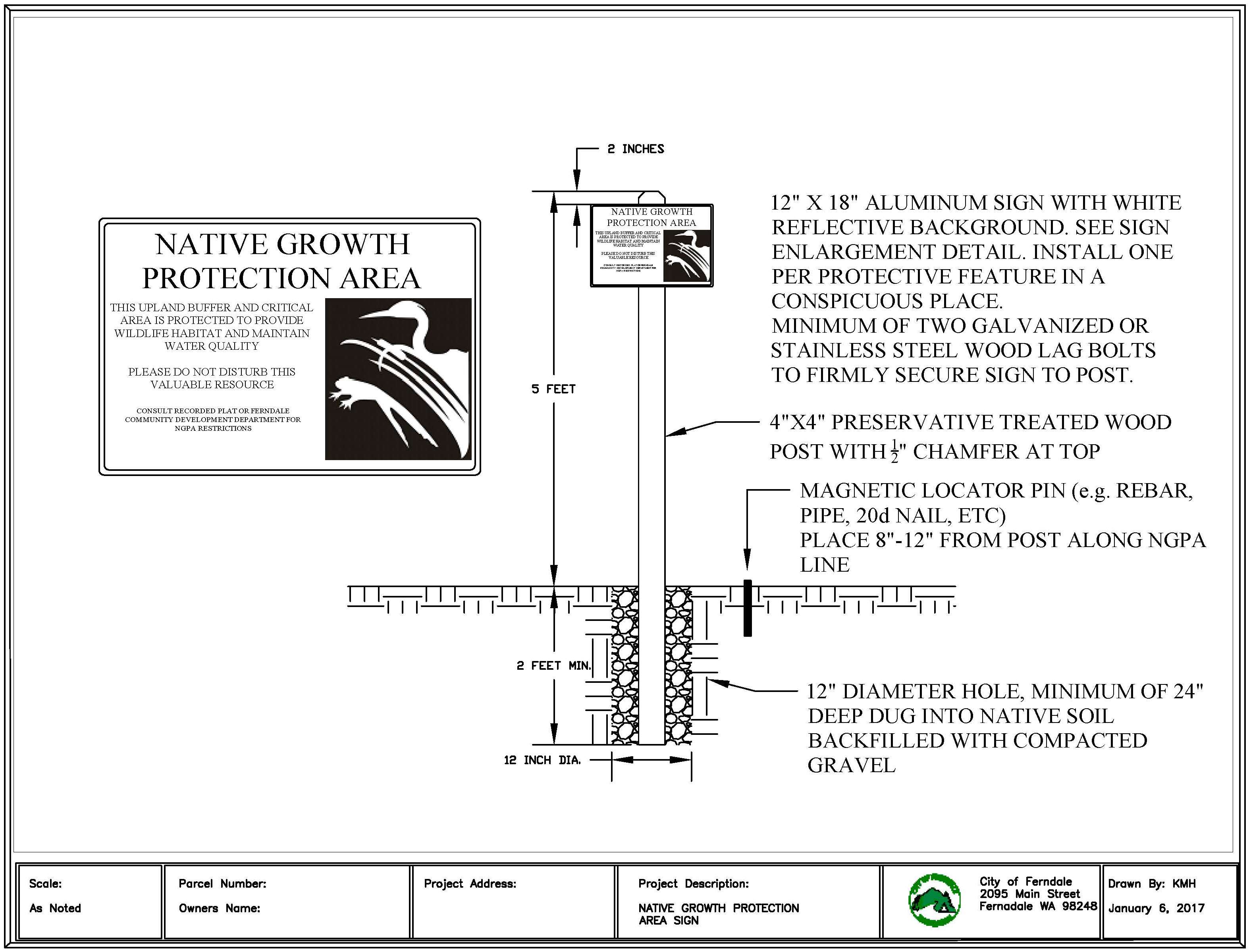
B. Signs and Fencing. Permanent signs shall be made of durable material and vandal-resistant, and shall be attached to a metal post or other material of equal durability. Signs must be posted at an interval of 100 feet or less, or as the Critical Areas Administrator deems necessary, and must be maintained and replaced by the property owner if the sign language is no longer visible. Any modification of the location or materials required for permanent signs shall be approved by the Critical Areas Administrator. The fence shall be constructed per the detail in the City Development Standards or constructed per the professional consultant as approved by the Critical Areas Administrator:
1. The Critical Areas Administrator may require the installation of a temporary construction fence along the construction limits adjacent to the critical area to prevent encroachment into the critical area during construction. The fencing shall be designed and installed to effectively prevent construction and related impacts. The fencing shall be installed and inspected prior to commencement of construction activities.
2. The Critical Areas Administrator may condition any permit or authorization issued pursuant to this chapter to require the applicant to install a permanent fence at the edge of the critical area and buffer when fencing will prevent future impacts to these features. Fencing materials shall not be made or treated with toxic materials. (Ord. 1987 § 1 (Exh. 1), 2017)
16.08.290 Stormwater management implications to wetlands and wetland buffers.
A. Stormwater management facilities are not allowed within wetlands. If an applicant requests that such a facility be constructed in a wetland, only Category IV wetlands shall be allowed for such use, and the City shall treat said proposed stormwater facility in the same manner as another development activity, requiring the same level of avoidance sequencing and mitigation per this chapter.
Stormwater management facilities shall not be located within wetland buffers, with the following exceptions:
1. Conveyance systems may be located in wetland buffers on a case-by-case basis if deemed necessary and approved by the Public Works and Community Development Departments.
2. Full dispersion of flow, as defined in Chapter 13.34 FMC, may be allowed in a wetland buffer if approved by the Public Works and Community Development Departments.
3. The facilities or methods specified in subsections (A)(1) and (2) of this section are allowed only if impacts to the buffer, resulting from their installation, are avoided or mitigated per FMC 16.08.230(A).
4. If a stormwater facility is proposed to be in a wetland buffer, the City shall treat said stormwater facility proposed in a wetland buffer in the same manner as another development activity, requiring the same level of avoidance sequencing and mitigation as any other.
B. Stormwater management design and facilities shall be consistent with Chapter 13.34 FMC, as amended. Native vegetation enhancement in wetland buffers may be approved for both buffer enhancement and as part of a best management practice to meet low impact development stormwater standards required by the Washington State Department of Ecology. Stormwater management design and facilities located within wetland buffers shall be designed in a way to protect wetland hydrology and wetland functions. Maintenance of said facilities shall follow those recommendations within the contents of an approved wetland mitigation plan. (Ord. 1987 § 1 (Exh. 1), 2017)
16.08.300 Wetland buffer requirements.
A. Standard Buffers. The buffer widths in Table 1 have been established in accordance with best available science. They are based on the category of wetland and habitat score as determined by a qualified consultant using the Washington State Wetland Rating System for Western Washington.
The Critical Areas Administrator may consider reductions in buffer width below those described in Table 1 based on site-specific analysis by a qualified wetland scientist or other approved qualified consultant, when that professional can demonstrate that the ecological functions of the critical area can be maintained at a level equal to or greater than the prescriptive buffers described in Table 1.
1. The use of the buffer widths in Table 1 requires the implementation of the measures in Table 2, where applicable, to minimize the impacts of the adjacent land uses.
2. The buffer widths in Table 1 assume that the buffer is vegetated with a native plant community appropriate for the ecoregion. If the existing buffer is unvegetated, sparsely vegetated, or vegetated with invasive species that do not perform needed functions, the buffer should either be planted to create the appropriate plant community or the buffer should be widened to ensure that adequate functions of the buffer are provided.
|
|
Buffer Width (in Feet) Based on Habitat Score |
|||
|---|---|---|---|---|
|
Wetland Category |
3-4 |
5 |
6-7 |
8-9 |
|
Category I: Based on total score |
75 |
105 |
165 |
225 |
|
Category I: Bogs and wetlands of high conservation value |
190 |
225 |
||
|
Category II (all) |
75 |
105 |
165 |
225 |
|
Category III (all) |
60 |
105 |
165 |
225 |
|
Category IV (all) |
40 |
|||
|
Disturbance |
Required Measures to Minimize Impacts (If Applicable) |
|
|---|---|---|
|
Lights |
• |
Direct lights away from wetland |
|
Noise |
• |
Locate activity that generates noise away from wetland |
|
• |
If warranted, enhance existing buffer with native vegetation plantings adjacent to noise source |
|
|
• |
For activities that generate relatively continuous, potentially disruptive noise, such as certain heavy industry or mining, establish an additional 10-foot heavily vegetated buffer strip immediately adjacent to the outer wetland buffer |
|
|
Toxic runoff |
• |
Route all new, untreated runoff away from wetland while ensuring wetland is not dewatered |
|
• |
Establish covenants limiting use of pesticides within 150 feet of wetland |
|
|
• |
Apply integrated pest management |
|
|
Stormwater runoff |
• |
Retrofit stormwater detention and treatment for roads and existing adjacent development |
|
• |
Prevent channelized flow from lawns that directly enters the buffer |
|
|
• |
Use low intensity development techniques |
|
|
Change in water regime |
• |
Infiltrate or treat, detain, and disperse into buffer new runoff from impervious surfaces and new lawns |
|
Pets and human disturbance |
• |
Use privacy fencing or plant dense vegetation to delineate buffer edge and to discourage disturbance using vegetation appropriate for the ecoregion |
|
• |
Place wetland and its buffer in a separate tract or protect with a conservation easement |
|
|
Dust |
• |
Use best management practices to control dust |
|
Disruption of corridors or connections |
• |
Maintain connections to off-site areas that are undisturbed |
|
• |
Restore corridors or connections to off-site habitats by replanting |
|
B. Buffer Measurement. Buffers shall be measured horizontally in a landward direction from the delineated wetland edge.
C. Increased Wetland Buffer Area Width. Buffer widths may be increased on a case-by-case basis as determined by the Critical Areas Administrator when it is necessary to protect wetland functions and values. This determination shall be supported by appropriate documentation prepared by a qualified consultant. The documentation must include but not be limited to the following criteria:
1. The wetland is used by a state or federally listed plant or animal species or has essential or outstanding habitat for those species, or has unusual nesting or resting sites such as heron rookeries or raptor nesting trees; or
2. The adjacent land is susceptible to severe erosion, and erosion-control measures will not effectively prevent adverse wetland impacts; or
3. The adjacent land has minimal vegetative cover or slopes greater than 30 percent.
D. Decreased Wetland Buffer Width and Buffer Averaging. A decreased buffer width and buffer averaging may be approved on a case-by-case basis as determined by the Critical Areas Administrator when site conditions are such that the wetland functions and values may be protected equally or better than prescriptive requirements by a lesser or averaged buffer. Buffer averaging to improve wetland protection may be permitted when all of the following conditions are met:
1. The wetland has significant differences in characteristics that affect its habitat functions, such as a wetland with a forested component adjacent to a degraded emergent component or a “dual-rated” wetland with a Category I area adjacent to a lower-rated area.
2. The buffer is increased adjacent to the higher-functioning area of habitat or more sensitive portion of the wetland and decreased adjacent to the lower-functioning or less sensitive portion as demonstrated by a critical areas report from a qualified consultant.
E. Averaging to allow use of a parcel may be permitted when all of the following are met:
1. There are no feasible alternatives to the site design that could be accomplished without buffer averaging.
2. The averaged buffer will not result in degradation of the wetland’s functions and values as demonstrated by a critical areas report from a qualified wetland consultant.
3. The total buffer area after averaging is equal to the area required without averaging and that no portion of the buffer is reduced by greater than 50 percent.
F. Buffer Variation. The standard buffer widths listed in Table 1 may be modified (increased, decreased or averaged) by the Critical Areas Administrator if the applicant can demonstrate the buffer reduction will not result in degradation of the wetland’s functions and values as demonstrated by a critical areas report from a qualified consultant based on best available science. (Ord. 1987 § 1 (Exh. 1), 2017; Ord. 1398 § 2, 2006. Formerly 16.08.260)
16.08.310 Wetland mitigation requirements.
A. Wetland mitigation is intended to compensate for the lost functions, values, and acreage of wetlands and buffers only when all reasonable methods for avoidance, minimization, rectifying, and reducing impacts have been explored and implemented.
B. A wetland technical report shall be prepared by a qualified consultant. Wetland mitigation is intended to compensate for the lost functions, values, and areal extent of the wetlands and buffers disturbed. Wetland mitigation shall be the mitigation ratios set forth in the table below, or as described in subsection (D) of this section. All projects that result in permanent or temporary loss or degradation of wetland functions and values or infringe within the regulated buffers shall provide compensatory mitigation based on best available science to offset the losses that will result from the proposed action(s).
A wetland mitigation plan shall be prepared by a qualified consultant that compensates for the impacts to the wetland or buffers by the proposed action/project. The wetland mitigation plan shall be written as per the criteria set forth within the most recent edition of the “Wetland Mitigation in Washington State – Part 2: Developing Mitigation Plans – Version 1” (Ecology Publication No. 06-06-011b, Olympia, WA, March 2006).
C. The wetland mitigation plan shall include an adequate description of the existing conditions as listed in the wetland detailed report (Appendix A).
D. The following ratios shall be used as guidance to determine the ratio of wetland or habitat to be created, restored, or enhanced in relation to the square footage of wetland impacted. Alternative ratios may be used if a qualified consultant can demonstrate there will be no net loss in wetland functions and values. One possible approach to modify the ratios in the table below is to use the credits and debits methodology.
|
Category and Type of Wetland |
Creation or Reestablishment |
Rehabilitation |
Enhancement |
|---|---|---|---|
|
Category I: Bog, natural heritage site |
Not considered possible |
Case by case |
Case by case |
|
Category I: Mature forested |
6:1 |
12:1 |
24:1 |
|
Category I: Based on functions |
4:1 |
8:1 |
16:1 |
|
Category II |
3:1 |
6:1 |
12:1 |
|
Category III |
2:1 |
4:1 |
8:1 |
|
Category IV |
1.5:1 |
3:1 |
6:1 |
E. A deed restriction shall be placed on the remaining on-site wetlands, wetland buffer, and mitigation area that protect the critical area from future development. If at any time the landowner believes that the critical area is no longer present, the landowner shall retain a qualified consultant to reassess the site. If the qualified consultant determines that the wetland is no longer present, the Administrator shall cause notification to be made to the relevant agencies such as the Department of Ecology or the Corps of Engineers to confirm the determination. (Ord. 1987 § 1 (Exh. 1), 2017; Ord. 1398 § 2, 2006. Formerly 16.08.270)
16.08.320 Alternative or innovative mitigation plans.
A. The City shall consider and may approve alternative or innovative mitigation plans for developments over 10 acres, planned unit developments (pursuant to Chapter 18.69 FMC), binding site plans (pursuant to Chapter 17.36 FMC) and/or development agreements (pursuant to RCW 36.70B.170 through 36.70B.210). If approved said plan shall be used to satisfy the requirements of this chapter and provide relief and/or deviation as appropriate from the specific standards and requirements there-of; provided, that the standards of impact avoidance and minimization shall remain as guiding principles in the application of these provisions and when it is demonstrated that all of following circumstances exist:
1. The proponent(s) demonstrates the organizational and fiscal capability to carry out the purpose and intent of the plan;
2. The proponent(s) demonstrates that long-term maintenance and monitoring will be adequately funded and effectively implemented;
3. There is a clear likelihood for success of the proposed plan based on supporting scientific information or demonstrated experience in implementing similar plans;
4. In terms of functional value, the proposed mitigation plan results in equal or greater protection and conservation of critical areas functions, services, and values than would be achieved using parcel-by-parcel regulations and/or traditional mitigation approaches;
5. The plan is consistent with the general purpose and intent of this chapter and the Comprehensive Plan;
6. The plan shall contain relevant management strategies considered effective and within the scope of this chapter and shall document when, where, and how such strategies substitute for compliance with the specific standards herein; and the plan shall contain clear and measurable standards for achieving compliance with the purposes of this chapter, a description of how standards will be monitored and measure over the life plan, and a fully funded contingency plan if any element of the plan does not meet standards for compliance;
7. The plan will not commit the City to additional direct expenditures or to a conceptual mitigation program for which the City is responsible for in full or in part, but which has not been formally approved by the City.
Alternative mitigation plans shall be reviewed concurrently with the underlying land use permit(s) and decisions to approve or deny such plans shall be made in accordance with the underlying permit process.
The plan shall be reviewed by the Critical Areas Administrator to ensure compliance with the general purpose and intent of this chapter and ensure accuracy of the data and effectiveness of proposed management strategies. In making this determination the Critical Areas Administrator shall consult with the State Departments of Fish and Wildlife, Ecology, Natural Resources, and/or other local, state, federal, and/or tribal agencies or experts.
If the Critical Areas Administrator finds the plan to be complete, accurate and consistent with the purposes and intent of this chapter, the designated decision-maker shall solicit comment pursuant to public notice provisions of Chapter 14.15 FMC prior to final approval/denial of permission of the plan to substitute for requirements and standards of this chapter. (Ord. 1987 § 1 (Exh. 1), 2017)
16.08.330 Mitigation banking.
A. The City may approve mitigation banking as a form of compensatory mitigation for wetland and habitat conservation area impacts when the provisions of this chapter require mitigation and when it is clearly demonstrated that the use of a bank will provide equivalent or greater replacement of critical area functions and values when compared to on-site mitigation; provided, that all of the following criteria are met:
1. Banks shall only be used when they provide significant ecological benefits including long-term conservation of critical areas, important species, habitats and/or habitat linkages, and when they are consistent with the City Comprehensive Plan and create a viable alternative to the piecemeal mitigation for individual project impacts to achieve ecosystem-based conservation goals.
2. The bank shall be established in accordance with the Washington State Draft Mitigation Banking Rule, Chapter 173-700 WAC or as revised, and Chapter 90.84 RCW and the federal mitigation banking guidelines as outlined in the Federal Register, Volume 60, No. 228, November 28, 1995, or latest adopted version. These guidelines establish the procedural and technical criteria that banks must meet to obtain state and federal certification.
3. Preference shall be given to mitigation banks that implement restoration actions that have been identified formally by an adopted shoreline restoration plan, watershed planning document prepared and adopted pursuant to Chapter 90.82 RCW, a salmonid recovery plan or project that has been identified on the Salmon Recovery Board Habitat Project List or by the Washington State Department of Fish and Wildlife as essential for fish and wildlife habitat enhancement.
B. Mitigation banks shall require a mitigation bank permit in accordance with FMC 14.09.060 approved by Ecology and may be subject to a formal review permitted by the City under the Type 3A process including public review as follows:
1. The bank sponsor shall submit a bank prospectus for city review. The prospectus shall identify the conceptual plan for the mitigation bank, including:
a. The ecological goals and objectives of the bank;
b. The rationale for site selection, including a site map and legal description of the prospective bank site;
c. A narrative demonstrating compliance with the City Comprehensive Plan, associated development standards and this chapter, and shoreline restoration plan, watershed planning documents prepared and adopted pursuant to Chapter 90.82 RCW, and/or the salmonid recovery plan and shoreline master program;
d. A description of the existing site conditions and expected changes in site conditions as a result of the banking activity, including changes on neighboring lands;
e. Conceptual site design;
f. Description of the proposed protective mechanism such as a conservation easement; and
g. Demonstration of adequate financial resources to plan, implement, maintain, and administer the project.
2. The Critical Areas Administrator shall review the bank prospectus either by participating in the state’s Mitigation Bank Review Team (MBRT) process and/or by hiring independent, third-party expertise to assist in the review.
3. If the Critical Areas Administrator determines that the bank prospectus is complete, technically accurate, and consistent with the purpose and intent of this chapter, he/she shall forward the prospectus to the Hearings Examiner for initial review and shall be decided upon by City Council.
4. City Council considers Hearings Examiner recommendation at a closed record public meeting. Based on the initial review, that the prospectus is valid, it shall issue a notice to proceed to the bank sponsor. The notice to proceed shall not be construed as final approval of the bank proposal, but shall indicate approval to proceed with the development of the mitigation bank instrument, which details all of the legal requirements for the bank.
5. Upon receipt of a draft mitigation banking instrument from the bank sponsor, the Critical Areas Administrator shall review the banking instrument and mitigation bank permit in consultation with the MBRT and/or other third-party expert. Following review of the mitigation banking instrument and preliminary mitigation bank permit, the Critical Areas Administrator shall make a recommendation to Council to certify and approve, conditionally certify and approve, or deny the bank proposal and mitigation bank permit.
6. Following receipt of the recommendation, the City Council shall proceed with review in accordance with the procedures outlined in FMC 14.09.060 for a final decision approval.
7. The bank sponsor shall be responsible for the cost of any third-party review.
C. The award of bank credits for an approved bank may be negotiated based on habitat acreage, habitat quality, and contribution to a regional conservation strategy that has been approved by the City and other appropriate regulatory agency(ies). Credit availability may vary in accordance with agreed upon performance criteria for the development of the resource value in question. Awarded bank credits, subject to the approval of the City and regulatory agency(s), may be made transferable. Whether out-of-kind mitigation credit will be allowed at a particular bank will require a fact-specific inquiry on a case-by-case basis for the project creating the impacts. (Ord. 1987 § 1 (Exh. 1), 2017)
16.08.340 Use of bank credits.
A. Credits from a wetland mitigation bank may be approved for use as compensation for unavoidable impacts to wetlands when:
1. The bank is certified under state rules;
2. The Critical Areas Administrator determines that the wetland mitigation bank provides appropriate compensation for the authorized impacts; and
3. The proposed use of credits is consistent with the terms and conditions of the certified bank instrument.
B. Replacement ratios for projects using bank credits shall be consistent with replacement ratios specified in the certified bank instrument.
C. Credits from a certified wetland mitigation bank may be used to compensate for impacts located within the service area specified in the certified bank instrument. In some cases, the service area of the bank may include portions of more than one adjacent drainage basin for specific wetland functions. (Ord. 1987 § 1 (Exh. 1), 2017)
16.08.350 In-lieu fee mitigation.
To aid in the implementation of off-site mitigation, the City may develop an in-lieu fee program. This program shall be developed and approved through public process 3B pursuant to FMC 14.09.070 and be consistent with federal rules, state policy on in-lieu fee mitigation, and state water quality regulations. An approved in-lieu-fee program sells compensatory mitigation credits to permittees whose obligation to provide compensatory mitigation is then transferred to the in-lieu program sponsor, a governmental or nonprofit natural resource management entity. Credits from an approved in-lieu-fee program may be used when subsections (A)(1) through (4) of this section apply:
A. In-Lieu Fee Mitigation. Credits from an approved in-lieu-fee program may be used when all of the following apply:
1. The approval authority determines that it would provide environmentally appropriate compensation for the proposed impacts.
2. The proposed use of credits is consistent with the terms and conditions of the approved in-lieu-fee program instrument.
3. Projects using in-lieu-fee credits shall have debits associated with the proposed impacts calculated by the applicant’s qualified consultant using the credit assessment method specified in the approved instrument for the in-lieu-fee program.
4. The impacts are located within the service area specified in the approved in-lieu-fee instrument.
B. Permittee-Responsible Mitigation. In this situation, the permittee performs the mitigation after the permit is issued and is ultimately responsible for implementation and success of the mitigation. Permittee-responsible mitigation may occur at the site of the permitted impacts or at an off-site location within the same watershed. Permittee-responsible mitigation shall be used only if the applicant’s qualified wetland professional consultant demonstrates to the approval authority’s satisfaction that the proposed approach is ecologically preferable to use a bank or ILF program, consistent with the criteria in this section. (Ord. 1987 § 1 (Exh. 1), 2017)
16.08.360 Watershed-based management plans.
A. The City may consider watershed-based management plans sponsored by a watershed improvement district, other special purpose districts, or other government agency. The review of this proposal shall follow process 3B pursuant to FMC 14.09.070.
B. If approved, said plan shall be used to satisfy the requirements of this chapter and provide relief and/or deviation as appropriate from the specific standards and requirements thereof; provided, that the standards of impact avoidance and minimization shall remain as guiding principles in the application of these provisions and when it is demonstrated that all of the following circumstances exist:
1. The proponent(s) demonstrate the organizational and fiscal capability to carry out the purpose and intent of the plan;
2. The proponent(s) demonstrate that long-term management, maintenance, and monitoring of the watershed will be adequately funded and effectively implemented;
3. There is a clear likelihood for success of the proposed plan based on supporting scientific information or demonstrated experience in implementing similar plans;
4. In terms of functional value, the proposed mitigation plan results in equal or greater restoration, protection, and conservation of the impacted critical areas than would be achieved using parcel-by-parcel regulations and/or traditional mitigation approaches;
5. The plan is consistent with the general purpose and intent of this chapter, the Comprehensive Plan, and an approved watershed plan prepared pursuant to Chapter 90.82 RCW (the State Watershed Management Act) or the plan is prepared under other local or state authority that is consistent with the goals and policies of an applicable and approved watershed plan prepared pursuant to Chapter 90.82 RCW;
6. The plan shall contain relevant management strategies considered effective and within the scope of this chapter and shall document when, where, and how such strategies substitute for compliance with the specific standards herein; and
7. The plan shall contain clear and measurable standards for achieving compliance with the purposes of this chapter, a description of how such standards will be monitored and measured over the life of the plan, and a fully funded contingency plan if any element of the plan does not meet standards for compliance.
C. Watershed-based management plans shall be approved by the City Council by ordinance and appended to this chapter.
The process for approval shall be as follows:
1. The plan shall be reviewed by the Critical Areas Administrator to ensure compliance with the purposes of this chapter, the City of Ferndale shoreline master program and with the Comprehensive Plan, and to ensure accuracy of the data and effectiveness of proposed management strategies. In making this determination the Critical Areas Administrator shall consult with the State Departments of Fish and Wildlife, Ecology, Natural Resources, and/or other local, state, federal, and/or tribal agencies or experts.
2. If the Critical Areas Administrator finds the plan to be complete, accurate, and consistent with the purposes and intent of this chapter, City Council shall solicit comment pursuant to the public notice provisions of FMC 14.09.070 prior to final approval/denial of permission of the plan to substitute for the requirements and standards of this chapter.
3. The City Council shall not approve watershed-based management plans that conflict with Chapter 90.82 RCW. (Ord. 1987 § 1 (Exh. 1), 2017)
Article VI. Fish and Wildlife Habitat Conservation Areas
16.08.370 Fish and wildlife habitat conservation areas designation.
Areas that meet any of the classification criteria established below shall be designated as fish and wildlife habitat conservation areas (HCA) and shall be subject to the provisions of this chapter. (Ord. 1987 § 1 (Exh. 1), 2017; Ord. 1398 § 2, 2006. Formerly 16.08.280)
16.08.380 Fish and wildlife habitat conservation areas classification.
A. Fish habitat conservation areas shall be classified as types S, F, Np, and Ns waters or as per the most recent edition of the water typing system: WAC 222-16-030.
B. Wildlife Habitat Conservation Areas. Wildlife habitat shall include those areas that meet any of the following criteria:
1. Areas where threatened, endangered or sensitive species (flora and fauna) have a primary association;
2. Habitats and species of local importance designated by the Ferndale City Council;
3. Stream corridors designated on the City critical areas map;
a. Shoreline streams as defined by WAC 173-18-410;
b. Fish-bearing streams have current, historic, or potential use by resident or anadromous fish;
c. Non-fish-bearing streams have no current, historic or potential use by anadromous or resident fish;
d. Drainage ditches are not streams and are defined as watercourses that are purely artificial, and do not have a headwater area;
4. The approximate location and extent of habitat conservation areas are shown on the following map adopted by the City, as revised: Washington Department of Fish and Wildlife Priority Habitat and Species maps;
5. Mature forested areas;
6. Areas in which state listed priority species are found, have a primary association with, or contain suitable habitat for said listed species, as listed on the Washington Department of Fish and Wildlife’s Priority Habitats and Species list.
7. Ponds and lakes that are naturally occurring or that have been created within the flow path of a typed stream.
8. Frequently flooded areas as determined by FEMA’s NFIP. (Ord. 1987 § 1 (Exh. 1), 2017; Ord. 1398 § 2, 2006. Formerly 16.08.290)
16.08.390 Fish and wildlife habitat conservation areas indicators.
The Critical Areas Administrator shall use the following indicators to determine the need for a fish and wildlife habitat conservation area technical report:
A. The site is located within an area listed as a fish and wildlife HCA or river/stream habitat in the City critical areas maps;
B. Documentation through any public resource information source that a fish and wildlife HCA exists on or adjacent to the site;
C. A finding by a qualified consultant that the presence of a fish and wildlife HCA is likely;
D. A reasonable belief by the Critical Areas Administrator through local information that a fish and wildlife HCA may exist on or adjacent to the site. Such a belief shall be supported through consultation with a qualified consultant;
E. Upon identification that a fish and wildlife habitat conservation area is present or likely to be present the Critical Areas Administrator shall require that a technical report be completed. (Ord. 1987 § 1 (Exh. 1), 2017; Ord. 1398 § 2, 2006. Formerly 16.08.300)
16.08.400 Fish and wildlife habitat conservation areas buffers.
Fish and wildlife habitat conservation areas are regulated by this chapter. Their regulated buffers are set forth below. Projects are not allowed within a fish and wildlife habitat conservation area or its buffer without following the procedures set forth in this chapter.
A. River/Stream.
1. River/Stream – Standard Buffers. The following standard buffers shall be established for all river/stream habitats based on performance criteria:
|
River/Stream Class |
Standard Buffer |
|---|---|
|
Type S Water |
200 feet |
|
Type F Water |
150 feet |
|
Type Np Water |
100 feet |
|
Type Ns Water |
25 feet |
2. Buffer Measurement. Buffers shall be measured horizontally in a landward direction from the ordinary high water mark of the stream or river. In situations where a stream or river is within a ravine that has a slope greater than 20 percent, the buffer shall be 25 feet from the top of the slope or the designated buffer, whichever is greater. In situations where there is a wetland adjacent to the typed water, the buffer with the greater distance shall apply.
3. Buffer Variation. The standard buffer width may be modified (increased, decreased, averaged) by the Critical Areas Administrator based on performance criteria of the existing conditions of a wildlife habitat conservation area or its buffer. Decreasing or averaging of buffers will not result in a loss of function to the associated HCA.
4. Stream Designations. The designations, e.g., stream typings, are indicated on the critical areas map. Field verification of the typing and buffers shall be confirmed and determined by a qualified consultant.
B. Wildlife Corridor. For wildlife habitat conservation areas such as the bald eagle (Haliaeetus leucocephalus) territories or great blue heron (Areaa herodias) colonies buffer recommendations set forth by the United States Fish and Wildlife Services National Bald Eagle Management Guidelines or other agency recommendations that pertain to such habitat(s) shall act as a default buffer. A qualified consultant (fish and wildlife habitat consultant) shall make recommendations based on the existing conditions and sensitivities of the habitat in question and the impacts the proposed conditions may have on said habitat.
C. A deed restriction shall be placed on the remaining on-site wildlife corridors, buffer, and mitigation area that protect the critical area from future development. (Ord. 1987 § 1 (Exh. 1), 2017; Ord. 1398 § 2, 2006. Formerly 16.08.310)
16.08.410 Fish and wildlife habitat conservation areas technical report.
A technical report, which may include a mitigation plan or habitat management plan that protects habitat as described above, shall be prepared by a qualified consultant prior to any land disturbance if the proposed land disturbance is likely to affect a protected species or habitat, is within a designated buffer, or is adjacent to a protected species or habitat. Appendix A describes the conditions required for the completion of a fish and wildlife habitat conservation area technical report. (Ord. 1987 § 1 (Exh. 1), 2017; Ord. 1398 § 2, 2006. Formerly 16.08.320)
Article VII. Geologically Hazardous Areas
16.08.420 Geologically hazardous areas designation.
Areas that meet any of the classification criteria established below shall be designated as geologic hazard areas and shall be subject to the provisions of this chapter. (Ord. 1987 § 1 (Exh. 1), 2017; Ord. 1398 § 2, 2006. Formerly 16.08.330)
16.08.430 Geologically hazardous areas classification.
Geologic hazard areas shall be classified as steep slopes, earthquake-sensitive areas and volcanic debris flow areas based on the following criteria:
A. Steep Slopes. Steep slopes shall include all areas with a slope inclination greater than or equal to 35 percent with a vertical relief of 10 or more feet.
B. Erosion Hazard Areas. Erosion hazard areas shall include:
1. Surface erosion areas, which include areas with slopes greater than 15 percent and with soils identified by the Natural Resources Conservation Service as having a severe or very severe rill and inter-rill erosion hazard because of natural characteristics, including vegetative cover, soil texture, slope, gradient, and rainfall patterns, or human-induced changes to natural characteristics.
C. Earthquake-Sensitive Areas. Earthquake-sensitive areas shall include:
1. Areas where manmade fill or partially decomposed organic material average at least five feet in depth;
2. Filled wetlands;
3. Alluvial deposits subject to liquefaction during severe shaking.
D. Volcanic Debris Flow Areas. Volcanic debris flow areas shall include all areas within the 100-year floodplain as designated in the Ferndale floodplain management ordinance, Chapter 15.24 FMC. Due to the relatively low frequency of catastrophic volcanic debris flow events, the protective measures contained in the Ferndale floodplain management ordinance (Chapter 15.24 FMC) are deemed sufficient to reduce potential risks from such events to acceptable levels. (Ord. 1987 § 1 (Exh. 1), 2017; Ord. 1398 § 2, 2006. Formerly 16.08.340)
16.08.440 Geologically hazardous areas indicators.
The Critical Areas Administrator shall use the following as indicators of the need for a geologically hazardous area detailed report:
A. The site is located within 200 feet of an area listed as steep slope or earthquake-sensitive area on the critical areas map;
B. Documentation through any public resource information source that a steep slope or earthquake-sensitive area exists on or within 200 feet of the site;
C. A finding by a qualified geologist or geotechnical engineer that the presence of a steep slope or earthquake-sensitive area is likely;
D. A reasonable belief by the Critical Areas Administrator that a steep slope or earthquake-sensitive area may exist on or within 200 feet of the site. Such a belief shall be supported through consultation with a qualified consultant;
E. Upon identification that a geologically hazardous area is present or likely to be present, the Critical Areas Administrator shall require that a technical report be completed (Appendix A);
F. A deed restriction shall be placed on the geologically hazardous area and buffer that protect the critical area from future development. (Ord. 1987 § 1 (Exh. 1), 2017; Ord. 1398 § 2, 2006. Formerly 16.08.350)
16.08.450 Geologically hazardous areas performance requirements.
Alteration of a steep slope or earthquake-sensitive area or a site within 200 feet of such area shall only be permitted if the technical report indicates that the project has been designed such that the risks associated with the hazard area have been reduced to within acceptable levels. Mitigation of risks to acceptable levels shall be certified by a professional engineer or a geotechnical engineer, i.e., a qualified consultant. (Ord. 1987 § 1 (Exh. 1), 2017; Ord. 1398 § 2, 2006. Formerly 16.08.360)
Article VIII. Critical Aquifer Recharge Areas
16.08.460 Critical aquifer recharge area designation.
Aquifer recharge areas shall be designated based on meeting any one of the following criteria:
A. Wellhead protection areas designated per Chapter 246-290 WAC;
B. Sole source aquifers designated by the U.S. EPA per the Federal Safe Drinking Water Act;
C. Areas designated for special protection as part of a groundwater management program per Chapter 90.44, 90.48, or 90.58 RCW or Chapter 173-100 or 173-200 WAC; or
D. Areas overlying unprotected aquifers used as a source of potable water.
E. Critical aquifer recharge areas may be added, reclassified or removed based on additional information about areas of significant potable water supply with susceptibility to groundwater contamination or based on changes to sole source aquifers or wellhead protection areas as identified in wellhead protection programs. (Ord. 1987 § 1 (Exh. 1), 2017; Ord. 1398 § 2, 2006. Formerly 16.08.370)
16.08.470 Exempted and prohibited uses.
A. The following activities shall be exempt from the review requirements of this critical area category:
1. Boundary line adjustments;
2. Building projects for individual, single-family residences, duplexes, triplexes, quadplexes and short plats which are not part of a larger development and which are connected to the sanitary sewer;
3. Conservation or preservation of soil, water, vegetation and wildlife in consultation with the Natural Resources Conservation Service, Washington Department of Fish and Wildlife, or other appropriate federal or state agency;
4. Grading permit for less than 500 cubic yards of material;
5. Installation, replacement, alteration or construction and operation in improved city road right-of-way of all water, sewer, drainage, or electric facilities, lines, equipment or appurtenances but excluding substations and the application of chemical substances;
6. Installation, replacement, alteration or construction and operation in improved city road right-of-way of all natural gas, cable communications and telephone facilities, lines, pipes, mains, equipment or appurtenances, but excluding the application of chemical substances;
7. Normal and routine maintenance or repair of existing utility structures or right-of-way, excluding the application of chemical substances; and
8. Site investigative work necessary for land use application submittals such as surveys, soil logs, percolation tests and other related activities.
B. Prohibited Uses.
1. Expansion or development of the following uses shall be prohibited within a designated wellhead protection areas:
a. Landfills (municipal sanitary solid waste and hazardous waste, demolition (inert) and wood waste);
b. Chemical/hazardous waste reprocessing transfer, storage and disposal facilities;
c. Wood and wood products preserving/treating;
d. Chemical (including pesticides) manufacturing, processing, mixing, manufacturing, and storage;
e. Gas stations without attendant;
f. Pipelines – liquid petroleum products or other hazardous liquid transmission;
g. Petroleum products refining, reprocessing and related storage (except underground storage of heating oil or agricultural fueling in quantities less than 1,100 gallons for consumptive use on the parcel where stored);
h. Vehicle wrecking/junk/scrap/salvage yards.
2. Expansion or development of the following uses within the one-year time of travel zone of a designated wellhead protection areas shall be prohibited:
a. Gas stations;
b. Maintenance/fueling facilities including but not limited to municipal, county, school district, transit, airports, railroads, buses;
c. Hazardous waste transfer and storage facilities, including radioactive wastes as defined in Chapter 43.200 RCW;
d. Fertilizer storage facilities;
e. Storage tanks, underground;
f. Solid waste handling, transferring, recycling; and
g. All other activities involving the use, handling, or storing of hazardous substances; of generating hazardous substances by their activities; or action in quantities exceeding the threshold in FMC 16.08.480. (Ord. 1987 § 1 (Exh. 1), 2017)
16.08.480 Wellhead protection areas – Existing uses.
A. The City in consultation with the Whatcom County Health Department shall request that an owner of any existing prohibited use facility which is located within a designated critical aquifer recharge area which uses, stores, handles or disposes of hazardous substances above the minimum cumulative quantities listed within this section submit a materials management (spill) plan that will ensure adequate protection of the aquifer and any domestic water supply. This plan shall be reviewed and updated as needed, and conditions under this plan shall be met on an ongoing basis. A materials management (spill) plans shall include, at a minimum, the following:
1. A brief description of business activities and a list and site map with the locations, amounts, and types of hazardous substances, waste and petroleum products, stored on site;
2. A description of inspection procedures for hazardous substance storage areas and containers and the minimum inspection intervals. An inspection logbook shall be maintained for periodic review by the county;
3. Provision of an appropriate spill kit with adequate spill supplies and protective clothing;
4. Detailed spill cleanup and emergency response procedures identifying how the applicant will satisfy the requirements of Chapter 173-303 WAC, Dangerous Waste Regulations, in the event that hazardous substance is released into the ground, groundwater, or surface water;
5. Procedures to report spills immediately to the Department of Ecology and the Environmental Health Division of the Whatcom County Public Health Department, in that order;
6. A current list of emergency phone numbers (e.g., the local fire district and ambulance);
7. Procedures to ensure that all employees with access to locations where hazardous substances are used or stored receive adequate spill training;
8. A map showing the location of all floor drains and any hazardous substances and petroleum product transfer areas; and
9. Additional information determined by the approval authority to be necessary to demonstrate that the use or activity will not have an adverse impact on groundwater quality.
10. Hazardous substances shall be stored in a secondary contaminant device or system that will effectively prevent discharge on site.
B. Any existing use which uses, stores, handles or disposes of hazardous materials above these minimum cumulative quantities will meet requirements described in subsection (A) of this section:
1. Chemical substances that are ignitable, corrosive, reactive or toxic, consistent with WAC 173-303-090, as amended, except as provided for below. Minimum cumulative quantity: 160 pounds or the equivalent of 20 gallons.
2. Cleaning substances for janitorial use or retail sale in the same size, packaging and concentrations as a product packaged for use by the general public. Chlorinated solvents and nonchlorinated solvents which are derived from petroleum or coal tar will not be considered a cleaning substance under this subsection, but rather a chemical substance under subsection (B)(1) of this section. Minimum cumulative quantity: 800 pounds (or the equivalent 100 gallons), not to exceed 55 gallons for any single package.
3. Businesses which use, store, handle or dispose of chemicals listed in WAC 173-303-9903 as “P” chemicals. Minimum cumulative quantity: one kilogram. (Ord. 1987 § 1 (Exh. 1), 2017)
16.08.490 Aquifer recharge area technical report requirements.
A. All other uses and activities (i.e., those not listed as exempted uses and activities or as prohibited uses and activities) shall be reviewed by the Critical Areas Administrator to determine the potential for significant adverse impacts.
B. If the potential for significant adverse impacts is present, then the Critical Areas Administrator shall require preparation of an aquifer recharge area technical report.
C. An aquifer recharge area technical study shall be prepared by a qualified hydrogeologist licensed in the State of Washington and with experience in preparing hydrogeological site assessments. Evidence of these qualifications shall be included with the technical report.
D. The technical report shall identify the existing hydrogeological conditions of the project site and the proposed activity’s potential to result in impacts to or alteration of groundwater resources.
E. The technical report shall also identify proposed mitigation measures necessary to reduce potential impacts to groundwater resources.
F. The technical report shall include those criteria designated in Appendix A. (Ord. 1987 § 1 (Exh. 1), 2017; Ord. 1398 § 2, 2006. Formerly 16.08.380)
16.08.500 Aquifer recharge area performance requirements.
Activities requiring preparation of an aquifer recharge area technical report shall only be permitted if the technical report indicates that the activity does not pose a significant threat to the underlying aquifer system. The Critical Areas Administrator shall establish mitigating conditions necessary to ensure protection of groundwater resources. (Ord. 1987 § 1 (Exh. 1), 2017; Ord. 1398 § 2, 2006. Formerly 16.08.390)
Article IX. Flood Hazard Areas
16.08.510 Flood hazard areas designation.
The areas of special flood hazard identified by the Federal Insurance Administration in a scientific and engineering report entitled “Flood Insurance Study, Whatcom County, Washington (All Jurisdictions),” dated May 30, 2003, with an accompanying flood insurance rate map, dated May 30, 2003, and any revisions thereto are adopted by reference and declared to be a part of this chapter as of January 16, 2004. The flood insurance study and flood insurance rate map are on file at City Hall, 2095 Main Street, Ferndale, WA 98248. (Ord. 1987 § 1 (Exh. 1), 2017; Ord. 1398 § 2, 2006. Formerly 16.08.400)
16.08.520 Flood hazard areas performance requirements.
All proposed development within designated flood hazard areas shall be consistent with the most current version of the City of Ferndale floodplain management regulations, Chapter 15.24 FMC. (Ord. 1987 § 1 (Exh. 1), 2017; Ord. 1398 § 2, 2006. Formerly 16.08.410)
Article X. Definitions
16.08.530 Definitions.
“Adaptive management” means the ability of a consultant within the context of a technical report to make changes with regard to updated best available scientific evidence regarding mitigation, protection, and identification of critical areas. Adaptive management also includes the ability to change a mitigation plan by varying the final design during construction or the monitoring period due to unforeseen conditions that provide a better result in the created environment. Changes within a design shall be based on best professional judgment and best available science and documented within an as-built or monitoring report.
“Adjacent” or “adjacent to” means 200 feet of any project that is likely to affect the functions or value of a critical area. When determining and describing adjacency, the existing conditions of the buffer shall be considered. These conditions include but are not limited to roads or buildings that may functionally isolate a critical area, forested areas and fields that provide habitat or protection to a critical area, and/or corridors, ditches, or streams (water flow conveyance) that provide a connection. In some situations, greater than 200 feet may be necessary to describe adjacency such as heron colonies, or stream water quality.
“Agriculture” means the tilling of the soil, the raising of crops, horticulture, livestock farming, dairying and/or animal husbandry. Agriculture excludes the following activities: hog farm, livestock feed lot, poultry farm, slaughterhouse, fertilizer works, bone yard, plant for the reduction or processing of animal matter, or similar manufacturing, processing, warehousing, storage, and related industrial and commercial activities whether or not dependent upon or closely allied to the agriculture industry.
“Anadromous fish” means fish species that ascend rivers and streams from the sea to spawn.
“Aquifer” means any geologic formation that will yield a significant amount of groundwater to a well, spring, or other withdrawal works, in sufficient quantity for beneficial use.
“Aquifer recharge areas” means areas where the prevailing geologic conditions allow infiltration rates which contribute significantly to the replacement of groundwater and which create a high potential for contamination of groundwater resources that serve as a source of potable water supplies.
“Artificial watercourse” means ditches and other water conveyance systems, not constructed from natural watercourses, which are artificially constructed and actively maintained for irrigation and drainage. Artificial watercourses include lateral field ditches used to drain farmland where the ditch did not replace a natural watercourse, roadside ditches, stormwater systems, or any other constructed drainage ditch.
“Best available science” means information gathered, analyzed and presented based on professional experience, expertise and judgment, and established scientific principles and practices. Such principles and practices include peer review, use of scientific methodology, logical analysis and reasonable inference, statistical analysis, rigorous referencing within the scientific literature, and conclusions drawn from within an accepted scientific framework and placed in an appropriate scientific context.
“Best management practices (BMP)” means physical or structural tools and/or management practices that, when used singularly or in combination, prevent or reduce adverse impacts to critical areas or their buffers.
“Biological assessment” means a report prepared by a qualified biologist or wetlands scientist that describes the biotic and abiotic aspects of the site and surrounding area. This includes, but is not limited to, the flora, fauna, plant communities, habitat(s), streams, wetlands, soils, and topography of and on the site and adjacent area.
“Biologist” means a person having specific relevant expertise who has a minimum of a bachelor’s degree in biological sciences or a related field from an accredited college or university or equivalent relevant training in fish and wildlife biology and demonstrated five years of experience as a practicing biologist in the related field.
“Buffer” or “buffer area” means the area adjacent to a critical area that is intended to protect the critical area from impacts to its functions and values, or that helps provide the margin of safety necessary to minimize risk to the public. This includes but is not limited to a naturally vegetated, undisturbed or revegetated zone immediately adjacent to a critical area. The area necessary to meet these objectives may vary significantly from property to property, and within a property itself.
“Compensatory mitigation” means replacing project-induced losses or adverse impacts to critical areas and includes, but is not limited to, in-kind restoration, creation, or enhancement.
“Contiguous” means land adjoining and touching other land regardless of whether or not portions of the parcel have separate assessor’s tax numbers, are purchased at different times, lie in different sections, are in different government lots, or are separated from each other by private roads or private rights-of-way.
“Creation” means actions intentionally performed to establish a critical area, or a portion of a critical area, where one did not formerly exist.
“Critical area designation” means identification of critical areas for regulatory purposes as indicated in the relevant sections of this chapter, such as wetlands using the Corps definition.
“Critical area indicators” means site-specific features such as vegetation, soils, hydrology, topography and other environmental features established through a site visit or other means that indicate that critical areas are or may be present at a particular location. For critical areas such as aquifer recharge areas, where indicators cannot be identified through a site visit, indicators may be identified through use of critical area maps or other resources.
“Critical area review” means the administrative and investigative process for decision making by the City on authorizations required by this chapter. The process begins with the filing of an application for an activity within the jurisdiction of this chapter and concludes with the final critical areas determination.
“Critical area technical report” means a thorough investigation of a proposed activity and the critical area(s) it may impact as required by this chapter (refer to Appendix A).
“Critical areas” means the following areas as required by Chapter 36.70A RCW and WAC 365-190-080, and as defined and regulated in this chapter: wetlands, geologically hazardous areas, fish and wildlife habitat conservation areas, frequently flooded areas, and aquifer recharge areas.
“Critical Areas Administrator” means the Ferndale Community Development Director and/or their duly authorized agent.
“Critical aquifer recharge areas” means areas with a critical recharging effect on aquifers used for potable water.
“Delineation” means the precise determination of wetland boundaries in the field according to the application of specific methodology as described in the most recent edition of the United States Army Corps of Engineers (Corps) Wetland Delineation Manual (Environmental Laboratory 1987) and Regional Supplement to the Corps of Engineers Wetland Delineation Manual: Western Mountains, Valleys, and Coast Region (Version 2.0) (Corps 2010) and as accepted by the Washington State Department of Ecology (Ecology) (Corps 2010), or most recent document, manuals or applicable materials published by the Corps or Ecology. The Corps manual is referenced in Appendix B of this chapter.
“Dike” means any manmade embankment or revetment normally set back from the river bank or channel in the floodplain for the purpose of keeping floodwaters from inundating adjacent land; material is normally clay.
“Drainage ditch” means an artificial watercourse constructed to drain surface or groundwater.
“Endangered species” means a native species that is designated by the state of Washington or federal fish or wildlife agency as likely to be extirpated from the state through loss of habitat, prey species, or loss of life.
“Enhancement” means an action that improves critical area functions or values.
“Final critical areas determination” means the determination by the Critical Areas Administrator that a development activity, as proposed or conditioned, is or is not adequate to mitigate potential impacts to affected critical areas and comply with applicable performance requirements. The determination will be either favorable or unfavorable, indicating that the proposed activity is or is not authorized.
“Fish and wildlife habitat conservation areas (HCA)” means areas that serve a critical role in sustaining needed habitats and species for the functional integrity of the ecosystems, and which, if altered, may reduce the likelihood that the species will persist over time. These areas may include, but are not limited to, rare or vulnerable ecological systems, communities, and habitat or habitat elements including seasonal ranges, breeding habitat, winter range, and movement corridors; and area with high relative population density or species richness. The definition does not include artificial features or constructs as irrigation delivery systems, irrigation infrastructure, irrigation canals, or drainage ditches that lie within the boundaries of and are maintained by a port district or an irrigation district or company.
“Frequently flooded areas” means areas of special flood hazard as designated and regulated pursuant to Chapter 15.24 FMC, Floodplain Management.
“Functional isolation” means a critical area is separated from a proposed project by a preexisting nonconforming use such as a road but the proposed project is still within the regulated buffer.
“Functions” means those natural processes performed by a critical area and its components.
“Geologically hazardous areas” means areas that, because of their susceptibility to erosion, sliding, earthquake, or other geologic events, are not suited to the siting of commercial, residential, or industrial development consistent with public health or safety concerns.
“Geologist” means a person who has received a degree in geology from an accredited college.
“Geotechnical engineer” means a person who is licensed as a civil engineer with the state of Washington and who has recent, related experience as a professional geotechnical engineer.
“Groundwater” means all waters that exist beneath the land surface or beneath the bed of any body of surface water, whatever may be the geological formation or structure in which such water stands or flows, percolates or otherwise moves.
“Habitats of local importance” are designated as fish and wildlife habitat conservation areas including those areas found to be locally important to cities.
“Hazardous substances” means any liquid, solid, gas, or sludge, including any material, substance, product, commodity, or waste, regardless of quantity, that exhibits any of the physical, chemical or biological properties described in WAC 173-303-090 or 173-303-100.
“Hydrogeologic,” as referred to in this chapter, is the report of groundwater.
“In-kind compensation” means to replace critical areas, such as wetlands, with substitute critical areas whose characteristics closely approximate those affected by a regulated activity.
“In-lieu fee” means a fee paid as compensation for impacting a critical area in place of completing compensatory mitigation. Any in-lieu fee paid shall go towards protection of habitat commensurate to compensate the lost functions and values of the critical area affected by a development.
“Initial critical areas determination” means the determination by the Critical Areas Administrator that a proposed activity is within or in proximity to a critical area or would have probable significant adverse impact to a critical area.
“Low impact trails” means exempted, low impact pedestrian trails in wetlands or buffers that are limited to permeable surfaces no more than five feet in width. These trails are generally not to be permitted in wetlands except for minor crossings that minimize impact. These trails are typically located in the outer 25 percent of a wetland buffer, and are designed to avoid removal of significant trees.
“Mature forest” is a coniferous forest that has a mean age stand greater than 75 years old or a deciduous forest that has a mean age stand greater than 50 years old. A stand is considered an area greater than five acres in size.
“Mitigation” means avoiding, minimizing, reducing, rectifying, eliminating or compensating, and monitoring the impact for project-induced, adverse impacts to critical areas.
“Mitigation bank” means a properly developed collection of existing, created, restored or enhanced wetlands and their protective buffers that are created or established using best available science to provide mitigation credits to offset future adverse impacts to wetlands from approved projects elsewhere.
“Mitigation plan” means a detailed plan indicating actions necessary to mitigate adverse impacts to critical areas.
“Modified natural watercourse” means that segment of a natural watercourse that has been modified and is maintained by diking and drainage districts, and where such modification was not the result of an illegal action.
“National wetland inventory” means an inventory that was developed by the U.S. Fish and Wildlife Service, which used aerial photography to map wetlands across the United States.
“Native vegetation” means plant species that are indigenous to the area.
“Natural watercourse” means any stream in existence prior to settlement that originated from a natural source. An example of a natural watercourse is a stream that originates in a wetland or upland area, flows through agricultural, rural and/or urban land, and ultimately empties into a saltwater bay or another watercourse. A natural watercourse may have been ditched or piped.
“Off-site” means an action away from the site or not on the site at which a critical area has been or will likely be adversely impacted by a regulated activity.
“On-site” means action on or immediately adjacent to the site at which a critical area has been or will likely be adversely impacted by a regulated activity.
“Ongoing agriculture” means the continuation of any existing agricultural activity including crop rotations as designated by the Natural Resources Conservation Service over the previous 10 years.
“Ordinary high water mark (OHWM)” means the mark on all lakes, streams, and tidal water that will be found by examining the bed and banks and ascertaining where the presence and action of waters are so common and usual, and so long continued in all ordinary years, as to mark upon the soil a character distinct from that of the abutting upland, in respect to vegetation as that condition exists on June 1, 1971, as it may naturally change thereafter, or as it may change thereafter in accordance with permits issued by a local government or the Department; provided, that in any area where the ordinary high water mark cannot be found, the ordinary high water mark adjoining salt water shall be the line of mean higher high tide and the ordinary high water mark adjoining fresh water shall be the line of mean high water (RCW 90.58.030.C).
“Out-of-kind compensation” is to replace critical areas, such as wetlands, with substitute critical areas whose characteristics do not closely approximate those affected by a regulated activity.
“Passive recreation” means use of the land that does not involve any land disturbance such as cutting vegetation, disturbing soil, or recreation vehicle use. Passive recreation includes but is not limited to bird watching, fishing, hiking, trails or boardwalks consistent with the Parks, Recreation and Trails Master Plan, provided such improvements seek to minimize impact to sensitive areas through their placement, construction, by including educational components, establishing trash and animal waste receptacles, and similar.
“Performance requirements” means specific, measurable criteria that a proposed development activity must conform to and that may be used to determine the degree to which said activity complies with the provisions of this chapter.
“Potable water” means water that meets the quality standards for drinking purposes as established by the state of Washington.
“Primary association” means habitat that is used by a plant or animal species that is necessary for survival, but does not include incidental areas used by faunal species.
“Qualified consultant (aquifer recharge)” means a hydrogeologist licensed in the State of Washington; or professional engineer, licensed in the State of Washington, who is also trained to analyze geologic, hydrologic, and groundwater flow systems.
“Qualified consultant (fish and wildlife habitat areas)” means a person with a degree in wildlife biology, ecology, fisheries, or a closely related field and a minimum of two years of experience related to the subject species/habitat type.
“Qualified consultant (geohazards)” means a professional geologist or geotechnical engineer, licensed by the state of Washington.
“Qualified consultant (wetlands)” means a wetland scientist certified by the Society of Wetland Scientists Professional Certification Program (SWS PCP).
“Reasonable use” means any one of the uses allowed within a given zone that has the least impact on the critical areas found on the subject property. For zones that allow single-family residential uses, this typically would mean a house that has a development footprint and landscaping of 3,500 square feet or less.
“Restoration” means the return of a critical area or buffer to a state in which its functions and values approach its unaltered state as closely as possible.
“Riparian area” means the portion of habitat extending from the ordinary high water mark (OHWM) of a stream to that part of the upland influenced by elevated water tables or flooding. It includes the area that directly influences the aquatic ecosystem, provided riparian areas associated with an existing system of dikes and levees shall not extend beyond the toe of the slope on the landward side of the dike or levee structure.
“Sensitive species” means a species, native to the state of Washington, that is vulnerable or declining and is likely to become endangered or threatened in a significant portion of its range within the state without cooperative management or the removal of threats as designated by WAC 232-12-011.
“Shoreline master program” means the shoreline master program of the City of Ferndale as codified in the Ferndale Municipal Code.
“Site assessment” means a site-specific analysis that identifies the presence of critical areas, classifies and designates each critical area, documents site conditions, analyzes project-generated impacts, and identifies appropriate mitigation measures. Site assessments include wetland reports, hydrogeologic reports, and habitat management plans.
“Slope” means an inclined earth surface, the inclination of which is expressed as the ratio of horizontal distance to vertical distance from the toe to the top of the surface. The slope may also be expressed as a percent based on the quotient of the vertical distance divided by the horizontal distance.
“Species of local importance” means those species that may not be endangered, threatened or sensitive from a statewide perspective, but are of local concern due to their population status, sensitivity to habitat manipulation, or other educational, cultural or historic attributes. A species shall only be considered as being of local importance upon official designation as such by the City Council.
“Stream” means a natural flow of water.
“Technical Review Committee meeting” is a meeting which includes the Directors of Community Development, and Public Works or their designees, and including the Fire Marshal or other personnel, for the purpose of reviewing a proposed development application and providing comments regarding conformance with City of Ferndale regulations.
“Technical report” means a thorough investigation of the subject parcel, the proposed activity, and the critical area(s) a proposed activity may impact as required by this chapter.
“Threatened species” means a species, native to the state of Washington, that is likely to become endangered in the foreseeable future throughout a significant portion of its range within the state without cooperative management or the removal of threats as designated by WAC 232-12-011.
“Values” means the desirable attributes associated with a critical area and its components that contribute to public health, safety and welfare, or biological diversity.
“Wetland” or “wetlands” means areas that are inundated or saturated by surface water or groundwater at a frequency and duration sufficient to support, and that under normal circumstances do support, a prevalence of vegetation typically adapted for life in saturated conditions. Wetlands generally include swamps, marshes, bogs, and similar areas. For the purposes of this chapter, those portions of a lake that meet the definitional criteria for “wetland” shall be regulated under the wetland section of this chapter. Wetlands do not include those artificial wetlands intentionally created from nonwetland sites, including, but not limited to, irrigation and drainage ditches, grass-lined swales, canals, detention facilities, wastewater treatment facilities, farm ponds, and landscape amenities, or those wetlands created after July 1, 1990, that were unintentionally created as a result of the construction of a road, street, or highway. Wetlands may include those artificial wetlands intentionally created from nonwetland areas created to mitigate conversion of wetlands.
“Wetland delineation” means mapping wetlands and establishing a wetland edge or boundary in accordance with the approved federal delineation manual and applicable regional supplement. Manual adopted under RCW 36.70A.175 pursuant to RCW 90.58.380.
“Wetland reconnaissance” means a site assessment of wetlands in accordance with the methodologies stipulated in the manual adopted under RCW 36.70A.175 pursuant to RCW 90.58.380.
“Wetland scientist” means a person who has earned a bachelor’s degree in science with specific or related course work in wetland ecology, hydrology or soils science from an accredited college or university and who has five years of professional experience in wetland delineation, functional assessment and mitigation or equivalent training and experience. A professional wetland scientist (PWS) certified through the Society of Wetland Scientists Professional Certification Program or Washington State may be required at the discretion of the Critical Areas Administrator.
“Wildlife corridor” means a linear travel route that is commonly used by faunal species. Wildlife corridors may include but are not limited to streams, riparian zones, flyways, fallow fields, or a connection of forested areas. Roads, developments, homesites, and agricultural fields may intersect wildlife corridors. (Ord. 2198 § 1 (Exh. 1), 2022; Ord. 1987 § 1 (Exh. 1), 2017; Ord. 1398 § 2, 2006. Formerly 16.08.420)
Article XI. Appendix A
Appendix A
A. Technical Report Criteria. The technical report is a report that describes the critical area, the existing conditions of the parcel and surrounding area, the proposed conditions, and may include how the proposed conditions will or may affect the regulated critical area. Actual contents of the technical report will vary depending on the critical area involved, the proposed development, and advice from the Critical Areas Administrator. A technical report may be or include a mitigation plan, wetland report, fish and wildlife habitat report, geologically hazardous area report, an aquifer recharge report, a flood hazard report, or other report that satisfies the requirements of this chapter.
In general, the technical report shall include:
1. A description of the methods used and names and qualifications of consultants performing the field work;
2. A location map of subject parcel;
3. A survey or drawing of the parcel with north arrow and scale;
4. A description of the biotic and abiotic conditions of the parcel, that includes at a minimum a description of the soils, vegetation, and hydrology;
5. The location, boundary and extent of the critical area and regulated buffer;
6. Detailed description of the critical area, its functions, values and/or associated hazard;
7. A description of the surrounding properties;
8. A description of critical areas within 200 feet of the subject parcel if practical;
9. A discussion of the regulations that pertain to the critical areas identified;
10. A separate compensatory mitigation plan if required by this chapter or suggestions regarding mitigating measures to offset and/or compensate for the effects the proposed development may have on the critical area.
B. Mitigation Plan. All proposed mitigation shall be contained in a proposed mitigation plan. Actual contents of the mitigation plan will vary depending on the critical area involved, the proposed development, type of mitigation proposed, and advice from the Critical Areas Administrator. At a minimum, the mitigation plan shall include the following:
1. A description and drawing of the existing conditions;
2. A description and drawing of the proposed conditions, i.e., project;
3. Proposed mitigation;
4. How the proposed mitigation will maintain or compensate for the lost functions and values of the critical area or reduce potential risks posed by the critical area;
5. Monitoring and/or inspections that are deemed necessary to ensure the adequacy of the proposed mitigation, a minimum five-year monitoring period is recommended;
6. Remedial measures that may be necessary based on the results of monitoring and/or inspection;
7. Professional expertise necessary to install, maintain, monitor or inspect proposed mitigation measures;
8. Any bonding deemed necessary to ensure performance and/or maintenance of the proposed mitigation;
9. All mitigation plans may include adaptive management strategies; and
10. Mitigation for biological work shall occur, in order of preference: (a) on-site and in-kind, (b) on-site and out-of-kind, (c) off-site, (d) out-of-kind.
C. Wetland Technical Report Requirements. A wetland technical report shall be completed by a qualified wetland specialist that adequately describes the existing conditions of the parcel and shall include at a minimum the following information:
1. The name and contact information of the applicant; the name, qualifications, and contact information for the primary author(s) of the wetland critical area report; a description of the proposal; identification of all the local, state, and/or federal wetland-related permit(s) required for the project; and a vicinity map for the project.
2. A statement specifying the accuracy of the report and all assumptions made and relied upon.
3. Documentation of any fieldwork performed on the site, including field data sheets for delineations, rating system forms, baseline hydrologic data, etc.
4. A description of the methodologies used to conduct the wetland delineations, wetland ratings, or impact analyses, including references.
5. Identification and characterization of all critical areas, water bodies, shorelines, floodplains, and buffers on or adjacent to the proposed project area. For areas off site of the project site, estimate conditions within 300 feet of the project boundaries using the best available information.
6. For each wetland identified on site and within 300 feet of the project boundary, provide: the wetland rating, including a description of and score for each function, per wetland ratings of this chapter; required buffers; hydrogeomorphic classification; wetland acreage based on a professional survey from the field delineation (acreages for on-site portion or estimate entire wetland area including off-site portions); Cowardin classification of vegetation communities; habitat elements; soil conditions based on site assessment and/or soil survey information; and to the extent possible, hydrologic information such as location and condition of inlets/outlets (if they can be legally accessed), estimated water depths within the wetland, and estimated hydro period patterns based on visual cues (e.g., algal mats, drift lines, flood debris, etc.). Provide acreage estimates, classifications, and ratings based on entire wetland complexes, not only the portion present on the proposed project site.
7. A description of the proposed actions, including an estimation of acreages of impacts to wetlands and buffers based on the field delineation and survey and an analysis of site development alternatives, including a no-development alternative.
8. An assessment of the probable cumulative impacts to the wetlands and buffers resulting from the proposed development.
9. A description of reasonable efforts made to apply mitigation sequencing pursuant to mitigation sequencing cited in FMC 16.08.230 to avoid, minimize, and mitigate impacts to critical areas.
10. A discussion of measures, including avoidance, minimization, and compensation, proposed to preserve existing wetlands and restore any wetlands that were degraded prior to the current proposed land-use activity.
11. A conservation strategy for habitat and native vegetation that addresses methods to protect and enhance on-site habitat and wetland functions.
12. An evaluation of the functions of the wetland and its buffer. Include references for the method used and data sheets.
13. A copy of the site plan sheet(s) for the project must be included with the written report and must include, at a minimum:
a. Maps (to scale) depicting delineated and surveyed wetland and required buffers on site, including buffers for off-site critical areas that extend onto the project site; the development proposal; other critical areas; grading and clearing limits; and areas of proposed impacts to wetlands and/or buffers (include square footage estimates).
b. A depiction of the proposed stormwater management facilities and outlets (to scale) for the development, including estimated areas of intrusion into the buffers of any critical areas. The written report shall contain a discussion of the potential impacts to the wetland(s) associated with anticipated hydroperiod alterations from the project.
D. Fish and Wildlife Habitat Conservation Areas Technical Report Requirements. A fish and wildlife HCA technical report shall be prepared by a qualified biologist and shall include the following:
1. Description of the methods used and names and qualifications of consultant(s) performing the field work;
2. Location map of subject parcel;
3. Survey of the parcel indicating property boundaries, north arrow, scale, and topography;
4. Identification of the type, location and extent of the HCA on the project site plan that adequately describes the existing conditions of the parcel;
5. A description of the surrounding properties;
6. A description of HCAs within 200 feet of the subject parcel if practical;
7. A regulatory analysis, including a discussion of any federal, state, tribal and/or local requirements or management recommendations that have been developed for the species and/or habitats in question;
8. This report may include a habitat management plan to protect or mitigate for disturbances to protected species.
E. Geologically Hazardous Areas Technical Report Requirements. A geologically hazardous area technical report shall be prepared by a qualified geologist or geotechnical engineer and shall include the following:
1. Identification of the type, location and extent of the hazard area on the project site plan;
2. An assessment of the geologic and engineering characteristics of the proposed sites;
3. A geotechnical analysis of the project in relation to the proposed site, including discussion of potential impacts on the hazard area, the project site and adjacent properties;
4. A mitigation plan, including documentation of preparation or concurrence by a professional engineer, discussing how the project has been designed to avoid or minimize risks associated with the identified hazard area.
F. Aquifer Recharge Area Technical Report Requirements. All proposals within a designated aquifer recharge area that require SEPA review shall be reviewed by the Critical Areas Administrator to determine the potential for adverse impacts to groundwater resources. If the potential for significant adverse impacts is present, then the Critical Areas Administrator shall require preparation of an aquifer recharge area technical report. An aquifer recharge area technical report shall be prepared by a qualified consultant such as a geologist or geotechnical engineer and shall include the following:
1. An aquifer recharge area technical report shall be prepared by a hydrogeologist licensed in the state of Washington with experience in preparing hydrogeologic site assessments. Evidence of these qualifications shall be included with the technical report.
2. The technical report shall identify the existing hydrogeologic conditions of the project site and the proposed activity’s potential to result in contamination of groundwater resources.
3. The technical report shall also identify proposed mitigation measures necessary to reduce potential impacts to groundwater resources.
G. Flood Hazard Areas Technical Report Requirements. A flood hazard areas report shall be prepared by a qualified professional who is a hydrologist, or engineer, who is licensed in the state of Washington with experience in preparing flood hazard assessments.
1. The site area of the proposed activity;
2. All areas of a special flood hazard area, as indicated on the flood insurance map(s), such as the 100-year flood elevation, 10- and 50-year flood elevations, floodway within 200 feet of the project area;
3. All other flood areas indicated on the flood insurance map(s) within 200 feet of the project area;
4. Proposed development, including the location of existing and proposed structures, fill, storage of materials, and drainage facilities, with dimensions indicating distances to the floodplain;
5. Clearing limits;
6. Elevation of the lowest floor (including basement) of all structures, and the level to which any nonresidential structure has been floodproofed. (Ord. 1987 § 1 (Exh. 1), 2017; Ord. 1398 § 2, 2006)
Article XII. Appendix B
Approved Resources
A. City of Ferndale Critical Areas Map: https://gisportal.cityofferndale.org/mapviewer/
B. U.S. Fish and Wildlife Service National Wetlands Inventory Map:
https://www.fws.gov/wetlands/Data/Mapper.html
C. Washington State Department of Natural Resources Forest Practices Water Typing map:
http://www.dnr.wa.gov/forest-practices-water-typing
D. Washington Department of Fish and Wildlife – Washington State Fish Passage Map Application:
http://wdfw.wa.gov/conservation/habitat/fish_passage/data_maps.html
E. Washington Department of Fish and Wildlife – Salmon Scape:
http://apps.wdfw.wa.gov/salmonscape/map.html
F. Washington Department of Fish and Wildlife – Priority Habitat Species (PHS): http://wdfw.wa.gov/mapping/phs/
G. U.S. Department of Agriculture Natural Resources Conservation Service Soils map:
http://websoilsurvey.nrcs.usda.gov/app/
H. Washington State Department of Ecology, November 8, 2008, water resource inventory area (WRIA) maps:
http://www.ecy.wa.gov/water/wria/
I. United States Army Corps of Engineers. 2012. National Wetland Plant List:
http://rsgisias.crrel.usace.army.mil/apex/f?p=703:1
J. United States Army Corps of Engineers (Corps), Wetland Delineation Manual (Environmental Laboratory 1987) and Regional Supplement to the Corps of Engineers Wetland Delineation Manual: Western Mountains, Valleys, and Coast Region (Version 2.0) (Corps 2010) and as accepted by the Washington State Department of Ecology (Ecology) (Corps 2010), or most recent document, manuals or applicable materials published by the Corps or Ecology.
K. Hruby, T. 2014. Washington State Wetland Rating System for Western Washington: 2014 Update (Publication No. 14-06-029). Olympia, WA: Washington Department of Ecology.
L. Hruby, T. 2012. Calculating Credits and Debits for Compensatory Mitigation in Wetlands of Western Washington, Final Report, March 2012 (Washington State Department of Ecology Publication No. 10-06-11).
M. Wetland Mitigation Sites Using a Watershed Approach (Western Washington) (Ecology Publication No. 09-06-32, Olympia, WA, December 2009). (Ord. 1987 § 1 (Exh. 1), 2017)