


Chapter 19.10
ZONING MAP AND DISTRICTS
Sections:
19.10.020 Establishment of zoning districts.
19.10.030 Official zoning map.
19.10.050 Interpretation of map boundaries.
19.10.060 Zoning regulations applicable within districts.
19.10.010 Purpose.
The purpose of this chapter is to establish zoning districts, zoning regulations, an official zoning map and map interpretation rules for the city of Fife. (Ord. 1317 § 3, 1998).
19.10.020 Establishment of zoning districts.
In order to carry out the purpose of this title in the interest of public health, safety and general welfare, the following zoning districts are hereby established:
|
Single-Family Residential |
SFR |
|
Small Lot Residential |
SLR |
|
Medium Density Residential |
MDR |
|
High Density Residential |
HDR |
|
Neighborhood Residential |
NR |
|
Neighborhood Commercial |
NC |
|
Community Commercial |
CC |
|
Regional Commercial |
RC |
|
Business Park |
BP |
|
Industrial |
I |
|
Public Use/Open Space |
POS |
|
Community Mixed Use |
CMU |
(Ord. 1654-07 § 1, 2007; Ord. 1584-06 § 1, 2006; Ord. 1404 § 2(Exh. C § 2), 2000; Ord. 1317 § 3, 1998).
19.10.030 Official zoning map.
The boundaries of the zoning districts are hereby established and delineated on the official zoning map entitled “City of Fife Zoning Map,” dated July 14, 1998. The map is hereby incorporated as a part of this title. The official zoning map may consist of more than one map sheet for ease of use. (Ord. 1317 § 3, 1998).
19.10.040 Rezones.
Rezones shall be made by ordinance and the resulting boundary change shall be reflected on the official zoning map. The rezone procedure shall be in conformance with Chapter 19.92 FMC. The rezone boundary, ordinance number and date shall be identified on the zoning map. A contract rezone or a planned development overlay shall be identified by the placement of the applicable ordinance number after the zoning district designation on the zoning map (i.e., SFR(3875)). (Ord. 1317 § 3, 1998).
19.10.050 Interpretation of map boundaries.
A. Rules of Interpretation. When uncertainty exists as to the boundaries of any zoning district shown on official zoning map, the following rules shall apply:
1. Where district boundaries are separated by a right-of-way, such boundaries shall extend to the centerline of such right-of-way. Where a district boundary and city limit are separated by a right-of-way, such boundary shall extend to such city limit;
2. Where a district boundary is indicated as approximately following the centerline of an alley, street, highway, freeway, railroad track, creek or river, such centerline shall be construed to be the district boundary;
3. Where a district boundary is indicated as approximately following a lot line, such lot line shall be construed to be the district boundary;
4. Where a district boundary divides a lot, the location of such boundary, unless the same is indicated by dimensions, shall be determined by use of the scale appearing on the official zoning map.
B. Uncertainty of District Boundary. If, after using the above rules, the director is unable to conclusively identify a district boundary, the planning commission shall recommend and the city council shall determine the location of the district boundary. (Ord. 1317 § 3, 1998).
19.10.060 Zoning regulations applicable within districts.
The regulations implementing FMC 19.02.020 are hereby established and declared to be in effect upon all land included within the boundaries of each and every zoning district shown upon the official zoning map.
A. Title Compliance. Except as provided elsewhere in this title:
1. No structure shall be erected and no existing structure shall be moved, altered, reconstructed, replaced or enlarged, nor shall any land or structure be used for any purpose or in any manner other than a use listed in this title as permitted in the zoning district in which such land or structure is located.
2. No structure shall be erected, nor shall any existing structure be moved, altered, reconstructed, replaced or enlarged to exceed in height the limit established by this title for the zoning district in which such structure is located.
3. No structure shall be erected nor shall any structure be moved, altered, reconstructed, replaced or enlarged, nor shall any open space surrounding any structure be encroached upon or reduced in any manner, except in conformity with the development requirements established by this title for the zoning district in which such structure is located.
4. No improvement, yard or open space on a lot shall be considered as providing improvement, yard or open space for another lot except as provided for by this title.
B. The “Marijuana Limited Zone Overlay Map” is hereby created, established, delineated and incorporated into this title (See Exhibit 1). The official Marijuana Limited Zone Overlay Map is on file with the city clerk.
1. Marijuana retail outlets may be allowed only in areas depicted as “Eligible Retail” within the regional commercial district subject to all requirements found in Chapter 19.44 FMC and FMC 19.68.085(B), Marijuana land uses.
2. Marijuana producing and marijuana processing may be allowed only in areas depicted as “Eligible Production and Processing” within the industrial district subject to all requirements found in Chapter 19.48 FMC and FMC 19.68.085(C), Marijuana land uses.
Exhibit 1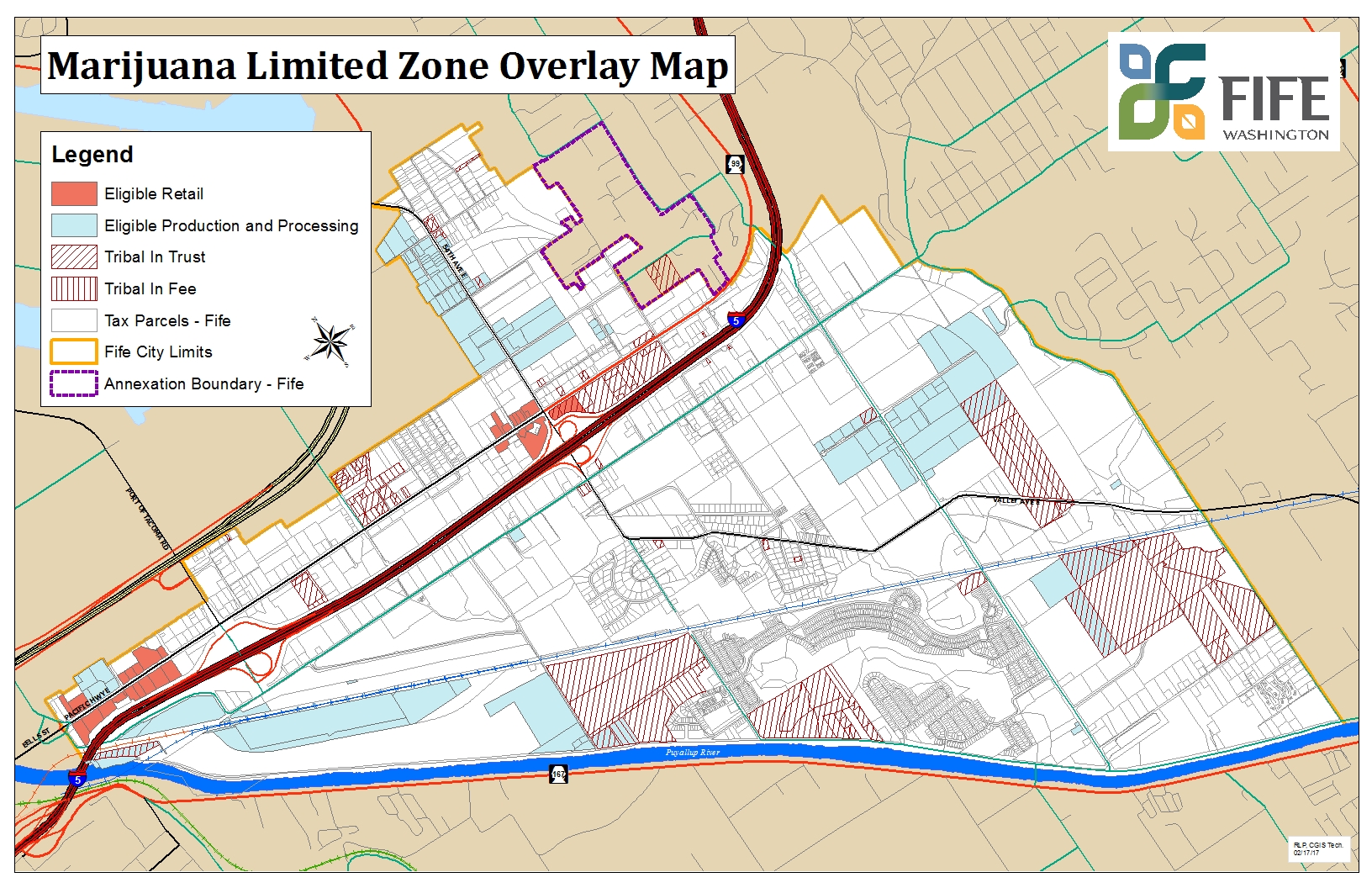
(Ord. 1957 § 6, 2017; Ord. 1317 § 3, 1998).