


Chapter 18.25
SHORELINE MASTER PROGRAM
Sections:
Article I. Introduction
18.25.030 Governing principles of this master program.
18.25.060 Critical areas regulations adopted by reference.
18.25.070 Relationship to other plans and regulations.
18.25.080 Liberal construction.
Article II. Definitions
Article III. Master Program Goals
18.25.130 Economic development.
18.25.140 Historic, archaeological, cultural, scientific and educational resources.
18.25.170 Restoration and enhancement.
18.25.190 Transportation, utilities and essential public facilities.
Article IV. Shoreline Jurisdiction and Environment Designations
18.25.200 Shoreline jurisdiction and mapping.
18.25.210 Shoreline environment designations – Purpose and criteria.
18.25.220 Uses allowed in each shoreline environment designation.
Article V. Shorelines of Statewide Significance
18.25.240 Designation of shorelines of statewide significance.
Article VI. General Policies and Regulations
18.25.270 Critical areas, shoreline buffers, and ecological protection.
18.25.280 Historic, archaeological, cultural, scientific and educational resources.
18.25.300 Shoreline setbacks and height.
18.25.310 Vegetation conservation.
18.25.320 Water quality and quantity.
Article VII. Shoreline Modifications Policies and Regulations
18.25.330 Applicability – Purpose.
18.25.340 Beach access structures.
18.25.370 Filling and excavation.
18.25.380 Flood control structures.
18.25.390 In-stream structures.
18.25.410 Structural shoreline armoring and shoreline stabilization.
Article VIII. Use-Specific Policies and Regulations
18.25.470 Industrial and port development.
Article IX. Permit Criteria and Exemptions
18.25.540 Substantial development permit criteria.
18.25.550 Exemptions from shoreline substantial development permit process.
18.25.570 Statements of exemption.
18.25.580 Variance permit criteria.
18.25.590 Conditional use permit criteria.
Article X. Administration and Enforcement
18.25.610 Administrative authority and responsibility.
18.25.620 Permit application review.
18.25.630 Minimum permit application requirements.
18.25.640 Preapplication conferences.
18.25.650 Notice of application and permit application review.
18.25.660 Nonconforming development.
18.25.665 State Environmental Policy Act (SEPA) compliance.
18.25.700 Expiration of permits and permit exemptions.
18.25.710 Permits and permit exemptions – Effective date.
18.25.720 Satisfaction of conditions required prior to occupancy or use.
18.25.730 Revisions following expiration of original permit or permit exemption.
18.25.740 Extensions – Notice to Ecology.
18.25.750 Notice of decision, reconsideration and appeal.
18.25.760 Initiation of development.
18.25.780 Rescission and modification.
18.25.790 Violations and penalties.
18.25.840 Master program amendments.
18.25.860 Transfer of permits.
Article XI. Official Shoreline Map
18.25.870 Official shoreline map.
Article I. Introduction
18.25.010 Purpose and intent.
(1) The purposes of this shoreline master program are to:
(a) Guide the future use and development of Jefferson County’s shorelines in a positive, effective, and equitable manner consistent with the Washington State Shoreline Management Act of 1971 (Chapter 90.58 RCW) as amended; and
(b) Promote the health, safety, and general welfare of the community by providing long range, comprehensive policies and effective, reasonable regulations for use and development of Jefferson County shorelines; and
(c) Ensure, at minimum, no net loss of shoreline ecological functions and processes; and
(d) Plan for restoring shorelines that have been impaired or degraded in the past; and
(e) Adhere to the policies contained in RCW 90.58.020 for shorelines of the state:
It is the policy of the State to provide for the management of the shorelines of the State by planning for and fostering all reasonable and appropriate uses. This policy is designed to insure the development of these shorelines in a manner, which, while allowing for limited reduction of rights of the public in the navigable waters, will promote and enhance the public interest. This policy contemplates protecting against adverse effects to the public health, the land and its vegetation and wildlife, and the waters of the State and their aquatic life, while protecting generally public rights of navigation and corollary rights incidental thereto...
In the implementation of this policy the public’s opportunity to enjoy the physical and aesthetic qualities of natural shorelines of the State shall be preserved to the greatest extent feasible consistent with the overall best interest of the State and the people generally. To this end uses shall be preferred which are consistent with control of pollution and prevention of damage to the natural environment or are unique to or dependent upon use of the State’s shoreline. Alterations of the natural condition of the shorelines of the State, in those limited instances when authorized, shall be given priority for single family residences, ports, shoreline recreational uses including but not limited to parks, marinas, piers, and other improvements facilitating public access to shorelines of the State, industrial and commercial developments which are particularly dependent on their location on or use of the shorelines of the State, and other development that will provide an opportunity for substantial numbers of the people to enjoy the shorelines of the State.
Permitted uses in the shorelines of the State shall be designed and conducted in a manner to minimize, insofar as practical, any resultant damage to the ecology and environment of the shoreline area and any interference with the public’s use of the water.
[Ord. 7-13 Exh. A (Art. I § 1)]
18.25.020 Applicability.
(1) All proposed uses and development, as defined in Article II of this chapter, occurring within shoreline jurisdiction shall comply with this program and Chapter 90.58 RCW. This program applies to all uses and developments within shoreline jurisdiction whether or not a shoreline permit or statement of permit exemption is required.
(2) This program’s shoreline uses and developments shall be classified as follows:
(a) Permitted Uses and Developments. Uses and developments that are consistent with this program and Chapter 90.58 RCW. Such uses/developments shall require a shoreline substantial development permit, a shoreline conditional use permit, a shoreline variance, and/or a statement that the use/development is exempt from a shoreline substantial development permit.
(b) Prohibited Uses and Developments. Uses and developments that are inconsistent with this program and/or Chapter 90.58 RCW and which cannot be allowed through any permit or variance.
(3) Classification of a use or development as permitted does not necessarily mean the use/development is allowed. It means the use/development may be permitted subject to review and approval by the county and/or the Department of Ecology. Many permitted uses/developments, including those that do not require a substantial development permit, can individually or cumulatively affect adjacent properties and/or natural resources and therefore must comply with this program in order to avoid or minimize such adverse impacts. The county may attach conditions of approval to any permitted use via a permit or statement of exemption as necessary to assure consistency of the project with the Shoreline Management Act and this program.
(4) This program shall apply to:
(a) All of the lands and waters of Jefferson County that fall under the jurisdiction of Chapter 90.58 RCW; and
(b) Every person, individual, firm, partnership, association, organization, local or state governmental agency, public or municipal corporation, or other nonfederal entity; and
(c) All nonfederal uses and developments undertaken on federal lands and on lands subject to nonfederal ownership, lease, or easement, even though such lands may fall within the external boundaries of federally owned lands1.
(5) Federal agencies are subject to this program and Chapter 90.58 RCW, as provided by the Coastal Zone Management Act (16 U.S.C. 1451 et seq. and WAC 173-27-060(1)).
(6) The provisions of this program shall not apply to lands held in trust by the United States for Indian Nations, tribes or individuals. Where tribal concerns are expressed in relation to SMP jurisdiction, those shall be resolved through appropriate government to government consultation in accordance with Washington State Centennial Accord and the RCW. [Ord. 7-13 Exh. A (Art. I § 2)]
18.25.030 Governing principles of this master program.
(1) The goals, policies and regulations of this program are based on the governing principles in WAC 173-26-186 and the policy statements of RCW 90.58.020.
(2) Any inconsistencies between this program and Chapter 90.58 RCW must be resolved in accordance with the RCW.
(3) The planning policies of this program may be achieved by diverse means, one of which is regulation. The county may also acquire land, implement capital projects and programs, encourage voluntary measures, create incentive programs, or use other means to implement this program’s planning policies.
(4) When regulating use and development of private property, the county’s actions must be consistent with all relevant legal limitations including constitutional limitations. This program must not unconstitutionally infringe on private property rights or result in an unconstitutional taking of private property.
(5) The regulatory provisions of this program are limited to shorelines of the state, whereas the planning functions of this program may extend beyond shoreline jurisdiction.
(6) The policies and regulations of this program must be integrated and coordinated with the policies and rules of the Jefferson County Comprehensive Plan (Comprehensive Plan) and its implementing development regulations adopted under the Growth Management Act (Chapter 36.70A RCW).
(7) The policies and regulations of this program are intended to protect shoreline ecological functions by:
(a) Requiring that current and potential ecological functions be identified and understood when evaluating new uses and developments.
(b) Requiring adverse impacts to be mitigated in a manner that ensures no net loss of shoreline ecological functions. Mitigation, as defined in Article II of this chapter, shall include avoiding first, then minimizing, and then replacing/compensating for lost functions and/or resources.
(c) Ensuring that all uses and developments, including preferred uses and uses that are exempt from a shoreline substantial development permit, will not cause a net loss of shoreline ecological functions.
(d) Preventing, to the greatest extent practicable, cumulative impacts from individual developments.
(e) Fairly allocating the burden of preventing cumulative impacts among development opportunities.
(f) Including regulations and regulatory incentives to restore shoreline ecological functions where such functions have been degraded by past actions. [Ord. 7-13 Exh. A (Art. I § 3)]
18.25.040 Title.
This document shall be known as the Jefferson County shoreline master program (“the master program” or “this program”). [Ord. 7-13 Exh. A (Art. I § 4)]
18.25.050 Adoption authority.
This master program is adopted under the authority granted by Chapter 90.58 RCW and Chapter 173-26 WAC. [Ord. 7-13 Exh. A (Art. I § 5)]
18.25.060 Critical areas regulations adopted by reference.
(1) The Jefferson County critical areas regulations contained in Chapter 18.22 JCC are integral and applicable to this program, and are hereby adopted by reference, except that:
(a) Nonconforming use and development within shoreline jurisdiction shall be subject to this program and not JCC 18.22.240.
(b) Exceptions to critical area and buffer standards shall be allowed as described in Article VI (JCC 18.25.270(5)) of this program.
(c) Activities that are exempt from critical areas regulation per JCC 18.22.230 shall comply with this program. Such activities may require a shoreline substantial development permit, shoreline variance, or shoreline conditional use permit unless this program and RCW 90.58.030(3)(e) specifically indicate the activity is exempt from shoreline substantial development permit requirements. This provision shall not apply to agricultural activities on agricultural lands, which are exempt from both JCC 18.22.230 and this program.
(2) The provisions of Chapter 18.22 JCC shall apply to any use, alteration or development within shoreline jurisdiction whether or not a shoreline permit or written statement of exemption is required.
(3) Within shoreline jurisdiction, the regulations of Chapter 18.22 JCC shall be liberally construed together with this program to give full effect to the objectives and purposes of the provisions of this program and Chapter 90.58 RCW.
(4) All references to the critical areas ordinance are for the version adopted on March 17, 2008, as Ordinance No. 03-0317-08, and further amended on May 11, 2009, as Ordinance No. 06-0511-09.
(5) Ocean uses and activities conducted within Jefferson County’s and the state of Washington’s jurisdiction shall comply with Chapter 43.143 RCW (Ocean Resources Management Act) and WAC 173-26-360 (Ocean Management). Nothing in this subsection is intended to expand or modify the applicability of Chapter 43.143 RCW, WAC 173-26-360, or any subsections thereof, to ocean uses and activities not otherwise governed by those laws, administrative rules, or their subsections. [Ord. 7-13 Exh. A (Art. I § 6)]
18.25.070 Relationship to other plans and regulations.
(1) Uses and developments regulated by this program may also be subject to other provisions of the JCC, the Jefferson County Comprehensive Plan, the Washington State Environmental Policy Act (Chapter 43.21C RCW and Chapter 197-11 WAC), and other local, state and federal laws.
(2) Project proponents are responsible for complying with all applicable laws prior to commencing any use, development or activity.
(3) Where this program makes reference to any RCW, WAC, or other state or federal law or regulation, the most recent amendment or current edition shall apply.
(4) In the event this program conflicts with other applicable county policies or regulations, all regulations shall apply and unless otherwise stated, the more restrictive provisions shall prevail. [Ord. 7-13 Exh. A (Art. I § 7)]
18.25.080 Liberal construction.
This program is exempt from the rule of strict construction; therefore this program shall be liberally construed to give full effect to its goals, policies and regulations. Liberal construction means that the interpretation of this document shall not only be based on the actual words and phrases used in it, but also by taking its deemed or stated purpose into account. Liberal construction means an interpretation that tends to effectuate the spirit and purpose of the writing. For purposes of this program, liberal construction means that the administrator shall interpret the regulatory language of this program in relation to the broad policy statement of RCW 90.58.020, and make determinations which are in keeping with those policies as enacted by the Washington State Legislature. [Ord. 7-13 Exh. A (Art. I § 8)]
18.25.090 Severability.
If any section or provision of this program is declared invalid it shall not affect the validity of this program as a whole. [Ord. 7-13 Exh. A (Art. I § 9)]
Article II. Definitions
18.25.100 Definitions.
These SMP definitions are derived from multiple sources. Definitions denoted with (*) are from this title. Definitions denoted with (**) are from Chapter 173-26 WAC. Definitions denoted with (***) are from Chapter 90.58 RCW. Definitions denoted with (****) are from the previously adopted county SMP (this chapter) and/or the proposed but not adopted 2000 Draft SMP. Definitions with no asterisk are derived from other sources or represent the best professional judgment of the authors.
(1) A Definitions.
(a) *“Abandon” means to terminate the use of a structure by an affirmative act such as changing to a new use; or to cease, terminate, or vacate a use or structure through nonaction. Except for ongoing agricultural activities, there shall be a presumption that a use has been abandoned if it is not undertaken, utilized, implemented or performed for a period of two years from the date of cessation/termination or vacation.
(b) *“Abutting” means adjoining with a common boundary line or any portion thereof.
(c) *“Accessory dwelling unit” means an additional dwelling unit either in or added to an existing single-family detached dwelling, or in a separate accessory structure on the same lot as the main structure, for use as a complete, independent living facility with provisions within the accessory dwelling unit for cooking, eating, sanitation and sleeping. Such a dwelling shall be considered an accessory use to the main dwelling and be clearly subordinate to the main dwelling.
(d) “Accessory structure” means any detached structure that is optional, incidental and subordinate to a primary use and located on the same lot as the primary use. Boathouses, barns, storage sheds, workshops, gazebos, docks, piers, floats, buoys, beach access structures and other similar structures are examples that are typically accessory to a primary use.
(e) *“Accessory use” means use of land or of a building or portion thereof incidental and subordinate to the principal use and located on the same lot with the principal use. Private moorage and other recreational uses are examples of uses that are accessory to residential development.
(f) ****“Accretion” means the slow addition of land by the deposition of water-borne sediment through the net effect of wave action and longshore drift.
(g) **“Act” means the Shoreline Management Act of 1971 (Chapter 90.58 RCW) as amended.
(h) *“Adequate” means acceptable but not excessive.
(i) *“Adjacent” means (in addition to abutting) that which is near or close; for example, an industrial district across the road or highway from a commercial district shall be considered as adjacent.
(j) *“Adjacent lands, shoreline” means lands adjacent to the shorelines of the state (outside of shoreline jurisdiction). See RCW 90.58.340.
(k) *“Administrator” means the Jefferson County department of community development director or a designated representative.
(l) *“Adverse impact or effect” means the result of a condition that creates, imposes, aggravates, or leads to inadequate, impractical, unsafe, or unhealthy conditions or reduces ecological functions or values.
(m) ****“Advertising” means publicly displayed messages or signs, billboards, placards, or buildings that direct attention to promotion of a business, service, or product.
(n) *“Aggrieved party” means a party of record who can demonstrate the following:
(i) The land use decision will prejudice the person;
(ii) The asserted interests are among those the county is required by county code, federal or state law or regulation to consider in making a land use decision; and
(iii) A decision on appeal in favor of the person would substantially eliminate or redress the prejudice alleged to be caused by the land use decision.
(o) **“Agricultural activities” means agricultural uses and practices including, but not limited to: producing, breeding, or increasing agricultural products; rotating and changing agricultural crops; allowing land used for agricultural activities to lie fallow in which it is plowed and tilled but left unseeded; allowing land used for agricultural activities to lie dormant as a result of adverse agricultural market conditions; allowing land used for agricultural activities to lie dormant because the land is enrolled in a local, state, or federal conservation program, or the land is subject to a conservation easement; conducting agricultural operations; maintaining, repairing, and replacing agricultural equipment; maintaining, repairing, and replacing agricultural facilities; provided, that the replacement facility is no closer to the shoreline than the original facility; and maintaining agricultural lands under production or cultivation.
(p) **“Agricultural land” means those specific land areas on which agriculture activities are conducted as of the date of adoption of this master program pursuant to the state guidelines (Chapter 173-26 WAC) as evidenced by aerial photography or other documentation. After the effective date of the master program, land converted to agricultural use is subject to compliance with the requirements of the master program.
(q) *“Agriculture, existing and ongoing” means any agricultural activity conducted on an ongoing basis on lands enrolled in the open space tax program for agriculture or designated as agricultural lands of long-term commercial significance on the official map of Comprehensive Plan land use designations; provided, that agricultural activities were conducted on those lands at any time during the five-year period preceding April 28, 2003. Agricultural use ceases when the area on which it is conducted is converted to a nonagricultural use.
(r) *“Agriculture, new” means agricultural activities proposed or conducted after April 28, 2003, and that do not meet the definition of existing ongoing agriculture.
(s) *“Allowed use” means uses allowed subject to the provisions of this program, including meeting applicable performance and development standards; if a shoreline permit, building permit or other development permit (e.g., stormwater permit) is required, the use is subject to the project review and approval process.
(t) “Alteration” means any human induced change in an existing condition of a shoreline and/or its buffer. Alterations include but are not limited to grading; filling; channelizing; dredging; clearing (vegetation); draining; constructing structures; compaction, excavation, or any other activity that changes the character of a site.
(u) *“Alteration, nonconforming structures” means any change or rearrangement in the supporting members of existing buildings, such as bearing walls, columns, beams, girders, or interior partitions, as well as any changes in doors, windows, means of egress or ingress or any enlargement to or diminution of a building or structure, horizontally or vertically, or the moving of a building from one location to another. This definition excludes normal repair and maintenance, such as painting or roof replacement, but includes more substantial changes.
(v) *“Alteration, nonconforming use” means the expansion, modification or intensification of a use that does not conform to the land use regulations of this program.
(w) “Anadromous fish” means fish species that spend part of their lifecycle in saltwater, but return to freshwater to reproduce.
(x) *“Appeal” means a request by an applicant or citizen that a decision made pursuant to this program be reviewed for its correctness and legality by another person, agency or court of law having jurisdiction to hear such an appeal.
(y) *“Applicant” means the owner or owners of record of the property subject to a project permit application under this program, or authorized representative thereof.
(z) *“Application” means the forms, plans and accompanying documents required for any project permit approval under this code.
(aa) “Appurtenance, normal” means a structure or use that is necessarily connected to a primary use and is located landward of the ordinary high water mark. Normal appurtenances for residential development are garages, utilities, septic tanks and drainfields, as well as driveways, walkways, and fences, plus initial clearing and grading for a new residence which does not exceed 250 cubic yards and which does not involve placement of fill in any wetland or waterward of the ordinary high water mark.
(bb) “Aquaculture” means the farming or culture of food fish, shellfish, or other aquatic plants or animals in freshwater or saltwater, and may include development such as structures, as well as use of natural spawning and rearing areas. Aquaculture does not include the harvest of wildstock geoduck on state-owned lands. Wildstock geoduck harvest is a fishery.
(cc) *“Aquaculture activity” means actions directly pertaining to growing, handling, or harvesting of aquaculture produce. Examples include, but are not limited to, propagation, tank farms, hatcheries, incubators/nurseries, stocking, feeding, disease treatment, depuration facilities, waste disposal, water use, development of habitat and structures, sorting, wet storage, and staging. Excluded from this definition are related commercial or industrial uses such as wholesale and retail sales, final processing and freezing.
(dd) *“Aquaculture facility or farm” means any facility or tract of land used to culture aquatic products. Each geographically separate facility or tract of land used for aquaculture shall constitute a separate facility/farm; provided, that adjoining farms/facilities with separate operators shall be considered separate facilities/farms.
(ee) *“Archaeological” means having to do with the scientific study of material remains of past human life and activities.
(ff) “Archaeological resource/site” means a geographic locality including, but not limited to, submerged and submersible lands and the bed of the sea that contains physical evidence of an indigenous and subsequent culture including material remains of past human life, monuments, symbols, tools, facilities, graves, skeletal remains and technological byproducts:
(i) That are associated with events that have made a significant contribution to the broad patterns of our history; or
(ii) That are associated with the lives of significant persons in our past; or
(iii) That embody the distinctive characteristics of a type, period or method of construction, or that represent the work of a master, or that possess high artistic values, or that represent a significant and distinguishable entity whose components may lack individual distinction; or
(iv) That have yielded or may be likely to yield, information important in history or prehistory.
(gg) “Archaeologist” is a person listed on the Washington State Department of Archaeology and Historical Preservation list of qualified archaeologists.
(hh) “Associated wetlands” means wetlands that are in proximity to tidal waters, lakes, rivers or streams that are subject to the Shoreline Management Act and either influence or are influenced by such waters. Factors used to determine proximity and influence include but are not limited to: location contiguous to a shoreline waterbody, formation by tidally influenced geohydraulic processes, presence of a surface connection including through a culvert or tide gate, location in part or whole within the 100-year floodplain of a shoreline, periodic inundation, and/or hydraulic continuity.
(ii) *“Average grade level” means the average of the natural or existing topography of the portion of the lot, parcel, or tract of real property on that part of the lot to be occupied by the building or structure as measured by averaging the elevations at the center of all exterior walls of the proposed structure. In the case of structures to be built over the water, the average grade level shall be the elevation of the ordinary high water.
(2) B Definitions.
(a) *“Backshore” means the area landward of the high tide line wetted by storm tides but normally dry. It may be a narrow gravel berm below a sea bluff or a broader complex of berms, marshes, meadows, or dunes.
(b) *“Barrier beach” means an accretion shore form of sand and gravel that has been deposited by longshore drift in front of bluffs, bays, marshes, or estuaries, and functions like a storm barrier.
(c) *“Bar” means a marine or river shore form similar to a spit or a hook, though generally not attached to the mainland during periods of high water.
(d) *“Beach” means the zone of unconsolidated material that is moved by waves, wind and tidal currents.
(e) *“Beach restoration and enhancement” means the alteration of terrestrial and tidal shorelines or submerged shorelines for the purposes of stabilization, recreational enhancement, or aquatic habitat creation or restoration. The materials used depend upon the intended use. For instance, to create a beach for recreational purposes, various grades of clean sand or pea gravel are often used. To restore or recreate a shore feature or an underwater aquatic environment (e.g., a reef), a combination of a rock matrix and sand or other materials may be used. To restore riparian habitat functions, native vegetation may be used.
(f) *“Base flood” means the flood having a one percent chance of being equaled or exceeded in any given year; also known as the 100-year flood, as shown on the FIRM maps.
(g) *“Base flood elevation” means the elevation for which there is a one percent chance in any given year that flood levels will equal or exceed it.
(h) “Beach access structure” means a structural pathway/walkway for purposes of providing pedestrian access to a beach or shoreline area, not for motorized vehicle access. It often includes a stairway, tram, stair tower, platform and/or elevated walkway anchored to the ground surface by structural means.
(i) “Beds of navigable waters” or “bedlands” means those lands lying waterward of and below the line of navigability on rivers and lakes not subject to tidal flow, or extreme low tide mark in navigable tidal waters, or the outer harbor line where harbor area has been created (RCW 79.105.060(2)).
(j) “Bedrock” means a general term for rock, typically hard, consolidated geologic material that underlies soil or other unconsolidated, superficial material or is exposed at the surface.
(k) “Berm” or “protective berm” means one or several accreted linear mounds of sand and gravel generally paralleling the shore at or landward of OHWM; berms are normally stable because of material size or vegetation, and are naturally formed by net-shore drift. Also, a linear mound used to screen an adjacent activity (e.g., a parking lot) from transmitting excess noise and glare.
(l) *“Best management practices (BMPs)” means systems of practices, schedules of activities, prohibitions, maintenance procedures, and management measures that prevent or minimize adverse impacts to the environment.
(m) ****“Bioengineering” or “biostabilization” means the practice of using natural vegetative materials to stabilize shorelines and prevent erosion. This may include use of bundles of stems, root systems, or other living plant material, soft gabions, fabric or other soil stabilization techniques, and limited rock toe protection where appropriate. Bioengineering projects often include habitat enhancement measures (e.g., anchored logs, root wads, etc.). Such techniques may be applied to creeks, rivers, lakes, reservoirs, and marine waters. Bioengineering may also be applied in upland areas away from the immediate shoreline.
(n) *“Board (BOCC)” means the board of county commissioners for Jefferson County. Also referenced as board of commissioners or county commissioners.
(o) *“Boat building and repair, commercial” means a commercial establishment where boats are constructed, dismantled, stored, serviced, or repaired, including maintenance work thereon.
(p) “Boating facilities” means any public or private facility for storing or launching vessels or watercraft. This includes marinas, open water moorage and anchorage areas, boat launch ramps, boat lifts, mooring buoys, piers, floats and docks or any other similar single-user or shared-use facility for public recreational use or private residential use. For purposes of this program, boathouses, boat repair shops, and other upland boat storage structures are not considered boating facilities.
(q) “Boathouse” means an enclosed structure designed and used exclusively for the storage of boats and boating equipment and not used as a dwelling unit.
(r) ****“Boat launch” or “boat ramp” means a slab, pad, plank, rail, or graded slope used for launching boats by means of a trailer, hand, or mechanical device.
(s) “Boat lift” is an in-water structure used for the dry berthing of vessels above the water level and lowering of vessels into the water periodically. A boat lift as herein defined is used to berth and launch a single vessel, suspended over the water’s surface. A boat lift is generally a manufactured unit without a canopy cover and may be placed in the water adjacent to a dock/pier or as a stand-alone structure. A boat lift may be designed either for boats or personal watercraft. A boat lift is to be differentiated from a hoist or crane used for the launching or haul-out of vessels.
(t) “Bottom culture” means all aquaculture systems that are set on or securely and rigidly attached to the tidelands or bedlands and do not extend higher than six feet from the bottom (excluding hoists and similar apparatus). Bottom culture includes but is not limited to geoduck tubes, oyster longlines, clam netting, oyster rack and bags, and clam bags. Bottom culture does not include aquaculture suspended from rafts or buoys or contained in floating net pens.
(u) ****“Breakwater” means an offshore structure that is generally built parallel to shore that may or may not be connected to land, and may be floating or stationary. Their primary purpose is to protect harbors, moorages and navigation activity from wave and wind action by creating stillwater areas along shore. A secondary purpose is to protect shorelines from wave caused erosion. Most breakwaters in the Pacific Coast are rip-rap mound construction.
(v) “Buffer” or “buffer zone, strip, or area” means the area adjacent to a shoreline or critical area that separates and protects the area from adverse impacts associated with adjacent land uses. A buffer is measured horizontally and perpendicularly from the ordinary high water mark, and includes the three-dimensional airspace above.
(w) “Building” means any structure used or intended for supporting or sheltering any use or occupancy as defined in the International Building Code.
(x) *“Building envelope” means:
(i) A three-dimensional space in which a building or structure may be built meeting septic requirements;
(ii) A plat restriction for the purpose of defining building coverage areas for individual lots, or for describing shoreline building setbacks;
(iii) The buildable area of a lot, tract or parcel after applicable setbacks, buffers, easements and other restrictions on the lot, tract or parcel are taken into account.
(y) ****“Bulkhead” means a wall usually constructed parallel to the shore with the primary purpose of containing and preventing the loss of soil caused by erosion or wave action. Bulkheads are usually constructed of rock, poured-in-place concrete, steel or aluminum sheet piling, wood or wood and structural steel combinations. They may be either thin structures penetrating deep into the ground, or more massive structures resting on the surface.
(3) C Definitions.
(a) *“Campground and camping facilities” means a facility in which sites are offered for persons using tents or other personal, portable overnight shelters. Campgrounds are for short-term stays and do not include trailer parks.
(b) “Canopy” means the collective branches and foliage of a single tree or group of trees, aggregate or collective tree crowns. A canopy can be closed or partially closed as in a forest or woodland stand, or composed of both individual trees and closed canopy groups as in an urban forest canopy.
(c) “Canopy cover” means the drip line area for an individual tree. For a stand of multiple trees it is the sum of the drip line areas of each tree less any overlap.
(d) ****“Channel” means an open water either naturally or artificially created to convey water.
(e) *“Channel migration zone (CMZ)” means an area within the lateral extent of likely stream channel movement that is subject to risk due to stream bank destabilization, rapid stream incision, stream bank erosion and shifts in the location of stream channels.
“Channel migration zone” includes:
(i) The historic channel migration zone (which is the footprint of the active channel documented through historical photographs and maps); and
(ii) The avulsion hazard zone (which is an area with the potential for movement of the main river channel into a new location); and
(iii) The erosion hazard area (which is an area outside the historic channel migration zone and the avulsion hazard zone, and includes an erosion setback for a 100-year period of time and a geotechnical setback to account for slope retreat to a stable angle of repose).
(iv) “High channel migration hazard” (or “high risk CMZ”) for the Big Quilcene, Little Quilcene, Dosewallips, Duckabush, and Lower Hoh Rivers means those nondisconnected portions of the channel that are likely to migrate within a 50-year timeframe.
(v) For the Big Quilcene, Little Quilcene, Dosewallips, and Duckabush Rivers, “moderate channel migration hazard” (or “moderate risk CMZ”) means those nondisconnected portions of the channel that are likely to migrate within a 50- to 100-year timeframe; and “low channel migration hazard” (or “low risk CMZ”) means those nondisconnected portions of the channel that are likely to migrate beyond a 100-year timeframe.
(vi) For the Lower Hoh River, “moderately high hazard” (or “moderately high risk CMZ”) means those nondisconnected portions of the channel that are likely to migrate within a 50- to 100-year timeframe, “moderate hazard” means those nondisconnected portions of the channel that are likely to migrate beyond a 100-year timeframe, and “low hazard” means the nondisconnected portions of the channel that are less likely to be affected by channel migration, but is still at risk due to its location on the valley floor.
“Channel migration zone” does not include disconnected migration areas, which are areas that have been disconnected from the river by legally existing artificial structure(s) that restrain channel migration (such as levees and transportation facilities build above or constructed to remain intact through the 100-year flood elevation), that are no longer available for migration by the river.
“Channel migration zone” may exclude areas that lie behind a lawfully established flood protection facility that is likely to be maintained by existing programs for public maintenance consistent with designation and classification criteria specified by public rule. When a natural geologic feature affects channel migration, the channel migration zone width will consider such natural constraints.
(f) “Channelization” means the straightening, relocation, deepening or lining of stream channels, including construction of continuous revetments or levees for the purpose of preventing gradual, natural meander progression.
(g) “Clearing” means the destruction or removal, by hand or with mechanical means, of vegetative ground cover, shrubs or trees. Clearing may or may not include removing root material or topsoil.
(h) “Cluster development” means a development design technique that groups or clusters buildings in specific areas on a site to minimize environmental impacts related to impervious surface, clearing and other impacts.
(i) “Commercial fish” means those species of fish that are classified under the Washington Department of Fish and Wildlife Food Fish Classification as commercial fish (WAC 220-12-010).
(j) *“Commercial recreational facility” means a place designed and equipped for sports and leisure-time activities that is operated as a business and open to the public for a fee.
(k) *“Commercial sign” means any object, device, display or structure that is used for attracting attention to any commercial use, product, service, or activity.
(l) *“Commercial use” means a business use or activity at a scale greater than a home business or cottage industry involving retail or wholesale marketing of goods and services. Examples of commercial uses include offices and retail shops.
(m) “Community dock” means a dock that serves multiple residential properties including upland and waterfront lots in a subdivision or similar community setting. See also “Shared use.”
(n) *“Compatible” means uses or activities capable of existing together or in the vicinity of one another without disharmony or without generating effects or impacts which are disruptive to the normal use and enjoyment of surrounding property.
(o) “Compensatory mitigation” means replacing resources or functions, at an equivalent or greater level, to offset unavoidable impacts that remain after all appropriate and practicable avoidance and minimization measures have been implemented. “Compensatory mitigation” includes, but is not limited to, creation, restoration, enhancement, preservation, and rehabilitation of wetlands, buffers, and other habitats or resources.
(p) *“Comprehensive Plan” means the Jefferson County Comprehensive Plan.
(q) “Conditional use permit (CUP)” means a permit issued by the county stating that the proposed land uses and development activities meet all criteria and all conditions of approval in accordance with the procedural requirements of this code. The intent of requiring a CUP is to accommodate site-specific allowances while ensuring program requirements are satisfied. As per Chapter 18.15 JCC, a CUP can be administrative (C(a)) or discretionary (C(d)). For this program, criteria are described in Article IX of this chapter and application review processes are described in Article X of this chapter.
(r) “Conservation” means the prudent management of rivers, streams, wetlands, wildlife and other environmental resources in order to preserve and protect them. This includes the careful use of natural resources to prevent depletion or harm to the environment.
(s) *“Conservation district” means a special purpose district, like a fire district or school district, organized in accordance with Chapter 89.08 RCW for the purpose of providing assistance to landowners for the conservation of renewable resources.
(t) “Conservation easement” means a legal agreement that the property owner enters into to restrict uses of the land for purposes of natural resources conservation. The easement is recorded on a property deed, runs with the land, and is legally binding on all present and future owners of the property.
(u) “Contaminant” means any chemical, physical, biological, or radioactive substance that does not occur naturally in ground water, air, or soil or that occurs at concentrations greater than those in the natural levels (Chapter 172-200 WAC).
(v) *“County” means Jefferson County, Washington, its board, commissions, and departments.
(w) ****“Covered moorage” means boat moorage, with or without walls, that has a roof to protect the vessel.
(x) ****Creek. See “Stream.”
(y) “Critical areas” mean the following areas as designated in Chapter 18.22 JCC:
(i) Critical aquifer recharge areas.
(ii) Wetlands.
(iii) Geologically hazardous areas.
(iv) Frequently flooded areas.
(v) Fish and wildlife habitat conservation areas.
(z) “Critical habitat” means habitat areas with which endangered, threatened, sensitive or monitored plant, fish, or wildlife species have a primary association (e.g., feeding, breeding, rearing of young, migrating). Such areas are identified herein with reference to lists, categories, and definitions promulgated by the Washington Department of Fish and Wildlife as identified in WAC 232-12-011 or 232-12-014; in the Priority Habitat and Species (PHS) program of the Department of Fish and Wildlife; or by rules and regulations adopted by the U.S. Fish and Wildlife Service, National Marine Fisheries Service, or other agency with jurisdiction for such designations. See also “Habitat of special significance.”
(aa) “Cumulative impacts” or “cumulative effects” means the combined impacts of a proposed development action along with past impacts and impacts of reasonably foreseeable future development actions.
(bb) “Current deflector” means an angled stub-dike, groin, or sheet-pile structure which projects into a stream channel to divert flood currents from specific areas, or to control downstream current alignment.
(cc) *“Current use” means the use of land or improvements at the time of permit application.
(4) D Definitions.
(a) “Dam” means a barrier across a stream or river to confine or regulate flow or raise water levels for purposes such as flood or irrigation water storage, erosion control, power generation, or collection of sediment or debris.
(b) *“DCD” means the Jefferson County department of community development.
(c) “Deepwater habitats” means environments where surface water is permanent and often deep, so that water, rather than air, is the principal medium in which the dominate organisms live.
(d) “Degrade” means to scale down in desirability or salability, to impair in respect to some physical property or to reduce in structure or function.
(e) ****“Delta” or “river delta” means those lands formed as an aggradational feature by stratified clay, silt, sand and gravel deposited at the mouths of streams where they enter a quieter body of water. The upstream extent of a river delta is that limit where it no longer forms distributary channels.
(f) *“Density” means the quantity per unit area, such as the number of dwelling units per acre.
(g) ***“Development” means a use consisting of the construction or exterior alteration of structures; dredging; drilling; dumping; filling; removal of any sand, gravel, or minerals; bulkheading; driving of piling; placing of obstructions; or any project of a permanent or temporary nature which interferes with the normal public use of the surface of the waters overlying lands subject to this program at any state of water level.
(h) ****“Developed shorelines” means those shoreline areas that are characterized by existing uses or structures located within shoreline jurisdiction.
(i) “Development agreement” means a binding legal agreement between a local government and a property owner, managing agent or controlling entity that establishes the standards and other provisions that apply to, govern and vest the development, use and mitigation of real property for the specified duration of time, as consistent with local regulations and Chapter 36.70B RCW.
(j) “Diameter at breast height (DBH)” means the diameter of a tree at four and one-half feet above the ground measured from the uphill side.
(k) “Dike” means an artificial embankment placed at a stream mouth or delta to hold back sea water.
(l) *“Director” means, unless otherwise specified, the director of the county’s department of community development (DCD) or the director’s designee.
(m) *“Division of land” means the creation of any new lot or lots for the purpose of sale, lease, or transfer of ownership (see Chapter 18.35 JCC).
(n) “Dock” means a fixed platform structure anchored in and floating upon a water body that abuts the shore to provide landing for water dependent recreation or moorage for vessels or watercraft and does not include above water storage.
(o) *“Drainage” means surface water runoff; the removal of surface water or ground water from land by drains, grading, or other means, which include runoff controls to minimize erosion and sedimentation during and after construction or development.
(p) “Dredge material disposal” means the depositing of dredged materials on land or into water bodies.
(q) “Dredging” means the removal of earth from the bottom of a stream, river, lake, bay, or other water body. This does not include de minimis removal of sediment during harvest of geoduck clams or other shellfish.
(r) **“Drift cell, drift sector, or littoral cell” means a particular reach of marine shore in which littoral drift may occur without significant interruption and which contains any natural sources of such drift and also accretion shore forms accreted by such drift.
(s) “Drip line area” means the area measured from the trunk of the tree outward to a point at the perimeter of the outermost branch structure of the tree.
(t) *“Driveway” means a strip of land which provides vehicular access to one or two lots.
(u) ****“Dune” means a hill or ridge of sand piled up by the wind and/or wave action.
(v) “Dwelling unit” means one or more rooms or structures designed for occupancy by an individual or family for living and sleeping purposes.
(5) E Definitions.
(a) **“Ecological functions” or “shoreline functions” means the work performed or role played by the physical, chemical, and biological processes that contribute to the maintenance of the aquatic and terrestrial environments that constitute the shoreline’s natural ecosystem. See WAC 173-26-200(2)(c). Functions include, but are not limited to, habitat diversity and food chain support for fish and wildlife, ground water recharge and discharge, high primary productivity, low flow stream water contribution, sediment stabilization and erosion control, storm and flood water attenuation and flood peak desynchronization, and water quality enhancement through biofiltration and retention of sediments, nutrients, and toxicants. These beneficial roles are not listed in order of priority.
(b) ****“Ecologically intact shorelines” means those shoreline areas that retain the majority of their natural shoreline functions and values, as evidenced by vegetation and shoreline configuration. Generally, but not necessarily, ecologically intact shorelines are largely free of structural shoreline modifications, structures, and intensive human activities.
(c) “Ecology” means Washington State Department of Ecology.
(d) **“Ecosystem processes” means the suite of naturally occurring physical and geologic processes of erosion, transport, and deposition; and specific chemical processes that shape landforms within a specific shoreline ecosystem and determine both the types of habitat and the associated ecological functions.
(e) “Emergency activities” are those activities that require immediate action within a time too short to allow full compliance with this program due to an unanticipated and imminent threat to public health, safety or the environment (see WAC 173-27-040). Emergency construction does not include development of new permanent protective structures where none previously existed. All emergency construction shall be consistent with the policies of Chapter 90.58 RCW and this program. As a general matter, flooding or other seasonal events that can be anticipated and may occur but that are not imminent are not an emergency.
(f) *“Endangered species” means a species which is in danger of extinction throughout all or a significant portion of its range, as classified by the Washington Department of Fish and Wildlife, the Washington Department of Natural Resources, or the Federal Endangered Species Act.
(g) “Enhancement” means actions performed within an existing degraded shoreline and/or buffer to intentionally increase or augment one or more functions or values of the existing area. Enhancement actions include, but are not limited to, increasing plant diversity and cover, increasing wildlife habitat and structural complexity (snags, woody debris), installing environmentally compatible erosion controls, or removing non-indigenous plant or animal species.
(h) *“Erosion” means the detachment and movement of soil or rock by water, wind, ice, or gravity.
(i) *“Erosion hazard areas” means areas characterized by soils identified in the USDA Jefferson County Soil Survey as having severe water erosion hazards.
(j) *“Essential public facilities” means those important and necessary facilities which provide essential services that are typically difficult to site, such as airports, state educational facilities, state or regional transportation facilities, state and local correctional facilities, solid waste handling facilities, and in-patient facilities including substance-abuse facilities, mental health facilities, and group homes (RCW 36.70A.200). They do not necessarily include all public facilities or services; they may be, but are not necessarily, publicly owned. Essential public facilities in Jefferson County include airports, large-scale transportation facilities, solid waste handling and disposal facilities, correctional facilities, in-patient treatment facilities including substance-abuse facilities and mental health facilities, state-owned educational facilities, and wastewater treatment plants.
(k) “Estuary” means a semi-enclosed coastal water body connected to a larger body of saltwater with one or more streams/rivers flowing into it. Estuaries are typically the mouths of rivers and have brackish water.
(l) *“Excavation” means the mechanical removal of earth, including soil, rocks, bedrock, and/or root material from areas landward of the OHWM of a waterbody.
(m) “Exempt development” refers to activities which the legislature identified as not requiring shoreline substantial development permits. Actions in shoreline jurisdiction not requiring such permits are required to be consistent with all the relevant policies and regulations in RCW 90.58.030 and WAC 173-27(040). A letter from the county must be obtained certifying that the development is exempt. Exempt uses may still require conditional use and/or variance permits.
(n) *“Existing use” means the use of a lot or structure or improvements at the time of the enactment of this code, unless otherwise specified.
(o) “Experimental aquaculture” means aquaculture that cultivates new species, or uses growing methods or harvesting techniques that have not previously been used in the state of Washington and that differ significantly from common practice.
(p) *“Extraction” means the commercial removal of naturally occurring materials from the earth, excluding water.
(q) ***“Extreme low tide (ELT)” means the lowest line of the land reached by a receding tide. This is the line as estimated by the federal government below which it might reasonably be expected that the tide would not ebb. In the Puget Sound area generally, this point is estimated by the federal government to be a point in elevation 4.50 feet below the datum plane of mean lower low water (0.0). Along the Pacific Ocean and in the bays fronting thereon and the Strait of Juan de Fuca, the elevation ranges down to a minus 3.5 feet in several locations.
(6) F Definitions.
(a) ****“Fair market value (FMV)” of a development means the open market bid price for conducting the work, using the equipment and facilities, and purchase of the goods, services and materials necessary to accomplish the development. This would normally equate to the cost of hiring a contractor to undertake the development from start to finish, including the cost of labor, materials, equipment and facility usage, transportation and contractor overhead and profit. The fair market value of the development shall include the fair market value of any donated, contributed or found labor, equipment or materials.
(b) **“Feasible” means, for the purpose of this program, that an action, such as a development project, mitigation, or preservation requirement, meets all of the following conditions:
(i) The action can be accomplished with technologies and methods that have been used in the past in similar circumstances, or studies or tests have demonstrated in similar circumstances that such approaches are currently available and likely to achieve the intended results;
(ii) The action provides a reasonable likelihood of achieving its intended purpose; and
(iii) The action does not physically preclude achieving the project’s primary intended legal use. In cases where these guidelines require certain actions unless they are infeasible, the burden of proving infeasibility is on the applicant. In determining an action’s infeasibility, the reviewing agency may weigh the action’s relative public costs and public benefits, considered in the short- and long-term time frames.
(c) (i) *“Feasible alternative” means an alternative that:
(A) Meets the requirements of federal, state, and local laws and regulations;
(B) Attains most or all of the basic objectives of the project;
(C) Is technically and technologically possible;
(D) Can be accomplished at a reasonable cost;
(E) Can be accomplished in a reasonable amount of time; and
(F) Adverse environmental, health, and safety effects are no greater than those of the original proposal.
(ii) A determination of what is reasonable or feasible is made by the decision-making body on a case-by-case basis, taking into account the:
(A) Probable intensity, severity, and cumulative impacts of the original proposal and alternative approaches, and opportunity for the avoidance or reduction in the number, intensity, or severity of significant impacts, or of the aggregate adverse impact;
(B) Risk of upset conditions (i.e., the risk that the control and mitigation measures will fail, be overwhelmed, or exceed allowed limits) and the potential severity of the impact should control or mitigation measures be ineffective or fail;
(C) Capital and operating costs;
(D) Period of time to accomplish, costs of additional time or delay, and time constraints for completion; and
(E) Location and site-specific factors, such as seasonal or topographic constraints, environmentally sensitive areas and habitats, site accessibility, and local community concerns.
(d) ****“Feeder bluff” means any coastal headland or hill with a broad, steep face experiencing periodic erosion from waves, sliding or slumping that, through natural transportation, contributes eroded earth, sand or gravel material via a driftway to an accretion shoreform.
(e) “Fill” means the addition of solid or semi-solid material such as soil, sand, rock, gravel, sediment, wood chips, mining overburden, earth retaining structure, or other material used to create any structure or infrastructure or when placed changes the elevation or grade of a receiving site.
(f) “Fill material” means any solid or semi-solid material such as soil, sand, rock, gravel, sediment, wood chips, mining overburden, earth retaining structure, or other material from mining or other excavation activities, and materials used to create any structure or infrastructure, that when placed, changes the grade or elevation of the receiving site.
(g) “Filling” means the act of transporting or placing by any manual or mechanical means fill material from, to, or on any soil surface, including temporary stockpiling of fill material.
(h) “Finfish” means a vertebrate organism of the classes Osteichthyes, Agnatha, or Chondrichthyes possessing a bony and/or cartilaginous inner skeleton, including all stages of development and the bodily parts of the fish (RCW 77.08.22). Examples include, but are not limited to, salmon, trout, ling cod, rock fish, halibut, sole, sablefish, perch, pollock, whiting, tilapia, carp, lamprey, sturgeon, sharks, skates, and rays. In comparison, see “Shellfish.”
(i) “Fire hazard” means the accumulation of combustible materials in such a condition as to be readily ignited and in such a quantity as to create a hazard from fire to nearby structures, life and property.
(j) “Fish habitat” means a complex of physical, chemical, and biological conditions that provide the life supporting and reproductive needs of a species or life stage of fish. Although the habitat requirements of a species depend on its age and activity, the basic components of fish habitat in rivers, streams, ponds, and nearshore areas include, but are not limited to, the following:
(i) Clean water and appropriate temperatures for spawning, rearing, and holding;
(ii) Adequate water depth and velocity for migrating, spawning, rearing, and holding, including off-channel habitat;
(iii) Abundance of bank and in-stream structures to provide hiding and resting areas and stabilize stream banks and beds;
(iv) Appropriate substrates for spawning and embryonic development. For stream and lake dwelling fishes, substrates range from sands and gravel to rooted vegetation or submerged rocks and logs. Generally, substrates must be relatively stable and free of silts or fine sand;
(v) Presence of riparian vegetation as defined in this article. Riparian vegetation creates a transition zone, which provides large woody debris (LWD), shade, and food sources of aquatic and terrestrial insects for fish;
(vi) Unimpeded passage (suitable gradient and lack of barriers) for upstream and downstream migrating juveniles and adults.
(k) “Float” means a fixed platform structure anchored in and floating upon a water body that does not connect to the shore, and that provides landing for water-dependent recreation or moorage for vessels or watercraft, and that does not include above water storage.
(l) “Floating aquaculture” means aquaculture systems that suspend aquatic organisms in the water column using buoys, rafts, docks, piers or other structure and that extend more than three feet from the bottom into the water column. Floating aquaculture is synonymous with hanging aquaculture.
(m) “Floating house” means any floating structure that is designed, or has been substantially and structurally remodeled or redesigned, to serve primarily as a residence. “Floating houses” include house boats, house barges, or any floating structures that serve primarily as a residence and do not qualify as a vessel. A floating structure that is used as a residence and is capable of navigation, but is not designed primarily for navigation, nor is normally capable of self propulsion and use as a means of transportation, is a floating house, not a vessel per WAC 332-30-103.
(n) *“Flood” or “flooding” means the temporary inundation of normally dry land areas from the overflow of inland or tidal waters or from the unusual and rapid accumulation or runoff of surface waters.
(o) “Flood control” means all development on rivers and streams designed to retard bank erosion, to reduce flooding of adjacent lands, to control or divert stream flow, or to create a reservoir, including but not limited to revetments, dikes, levees, channelization, dams, weirs, flood and tidal gates. Excluded are water pump apparatus.
(p) **“Floodplain” is synonymous with 100-year floodplain and means that land area susceptible to inundation with a one percent chance of being equaled or exceeded in any given year. The limit of this area shall be based upon flood ordinance regulation maps or a reasonable method which meets the objectives of the Act.
(q) “Floodplain management” means a long-term program to reduce flood damages to life and property and to minimize public expenses due to floods through a comprehensive system of planning, development regulations, building standards, structural works, and monitoring and warning systems.
(r) “Floodway” means the area of a river valley that conveys flood waters with reasonable regularity, although not necessarily annually. At a minimum, the floodway is that which has been established in Federal Emergency Management Act flood insurance rate maps or Federal Emergency Management Act floodway maps. Other data and information, including topography, changes in soil or vegetation, and other indicators of past flooding, may be used to define and map a floodway that meets the objectives of the Shoreline Management Act, Chapter 90.58 RCW. The floodway shall not include those lands that can reasonably be expected to be protected from 100-year flood waters by flood control devices maintained by or maintained under license from the federal government, the state, or a political subdivision of the state.
(s) “Forest land” means all land that is capable of supporting a merchantable stand of timber and is not being actively used, developed, or converted in a manner that is incompatible with timber production.
(t) *“Forest management” means forest practices pertaining to protecting, producing, and harvesting timber for economic use.
(u) *“Forest practice” means any activity conducted on or directly pertaining to forest land and relating to growing or harvesting of timber, or the processing of timber, including but not limited to: road and trail construction and maintenance; harvest, final and intermediate; precommercial thinning; reforestation; fertilization; prevention and suppression of diseases and insects; salvage of trees; and brush control.
(v) *“Forest practice, conversion” means the conversion of land to an active use incompatible with timber growing and where future nonforest uses will be located on currently forested land.
(w) *“Frequently flooded areas” means lands subject to a one percent or greater chance of flooding in any given year.
(x) “Function assessment” or “functions and values assessment” means a set of procedures, applied by a qualified consultant, to identify the ecological functions being performed in a shoreline or critical area, usually by determining the presence of certain characteristics, and determining how well the area is performing those functions. Function assessments can be qualitative or quantitative and may consider social values potentially provided by an area. Function assessment methods must be consistent with best available science.
(7) G Definitions.
(a) “Gabions” means works composed of masses of rock, rubble, or masonry tightly enclosed usually by wire mesh so as to form massive blocks. They are used to form walls on beaches to retard wave erosion or as foundations for breakwaters or jetties.
(b) “Game fish” means those species of fish that are classified by the Washington Department of Fish and Wildlife as game fish (WAC 232-12-019).
(c) “Genetically modified organism (GMO)” means a plant, animal or microorganism whose genetic material has been manipulated by a molecular biological engineering technique (such as recombinant DNA technology using transgenic or cisgenic methods) resulting in a genetically distinct organism with an altered hereditary pattern of protein production by the chromosomes. Selective breeding, cross breeding, and creation of polyploidy are not included.
(d) *“Geologically hazardous areas” means areas that because of their susceptibility to erosion, sliding, earthquake, or other geological events are not suited to the siting of commercial, residential, or industrial development consistent with public health or safety concerns.
(e) “Geologically unstable” means the relative instability of a shoreform or land form for development purposes over the long term or the intended life of any proposed structure. Soil, slope, ground or surface water, other geologic conditions, vegetation and effects of development are common factors that contribute to instability. Areas characterized by banks or bluffs composed of unconsolidated alluvial or glacial deposits (till and drift material), severely fractured bedrock, active and substantial erosion, substantially deformed trees and shrubs, or active or inactive earth slides are likely to be considered geologically unstable.
(f) “Geotechnical report” or “geotechnical analysis” means a scientific study or evaluation that includes a description of the ground and surface hydrology and geology, the affected land form and its susceptibility to mass wasting, erosion, and other geologic hazards or processes, conclusions and recommendations regarding the effect of the proposed development on geologic conditions, the adequacy of the site to be developed, the impacts of the proposed development, alternative approaches to the proposed development, and measures to mitigate potential site-specific and cumulative geological and hydrological impacts of the proposed development, including the potential adverse impacts to adjacent and down-current properties. Geotechnical reports shall conform to accepted technical standards and must be prepared by qualified engineers or geologists who are knowledgeable about the regional and local geology.
(g) *“Grade, existing” means the elevation of the ground or site prior to any work being done or any changes being made to the ground or site.
(h) *“Grade, finished” means the final elevation of the ground level after development.
(i) “Gradient” means a degree of inclination, or a rate of ascent or descent, of an inclined part of the earth’s surface with respect to the horizontal; the steepness of a slope. It is expressed as a ratio (vertical to horizontal), a fraction (such as meters/kilometers or feet/miles), a percentage (of horizontal distance), or an angle (in degrees).
(j) *“Grading” means stripping, cutting, filling, or stockpiling earth to create new grade.
(k) “Groin” means a wall-like structure extending on an angle waterward from the shore. Its purpose is to build or preserve an accretion shoreform or berm on its updrift side by trapping littoral drift. Groins are relatively narrow in width but vary greatly in length. Groins are sometimes built in series as a system, and may be permeable or impermeable, high or low, and fixed or adjustable.
(l) “Ground water” means all water that exists beneath the land surface or beneath the bed of any stream, lake or reservoir, or other body of surface water within the boundaries of the state, whatever may be the geological formation or structure in which such water stands or flows, percolates or otherwise moves (Chapter 90.44 RCW).
(m) *“Growth Management Act (GMA)” means the State of Washington Growth Management Act, Chapter 36.70A RCW, as amended.
(n) ****“Guidelines” means those standards adopted under Chapter 173-26 WAC, as amended, or any successor regulations thereof, that serve as standards for implementation of the policy of Chapter 90.58 RCW for regulations of uses of the shorelines, and that provide criteria to local governments and the Department of Ecology in developing master programs.
(8) H Definitions.
(a) *“Habitat” means the place or type of site where a plant or animal naturally or normally lives and grows.
(b) “Habitat of special significance” means eelgrass beds, kelp beds, rocky reef habitat, geoduck beds, hardshell clam beds, habitat having significant populations of or which are important to the feeding, reproduction or other life stages of Dungeness crabs, herring, lingcod/greenling, true cod, soles and flounders, rock fishes, cabezon and other large sculpins, or sea perch, wildlife refuges and habitats of endangered or threatened species, and other habitat that meets the 1986 Interim Guidelines for Salmon Net Pen Culture in Puget Sound, as determined on a case-by-case basis in consultation with Washington Department of Fish and Wildlife. See also “Critical habitat.”
(c) Hanging Aquaculture. See “Floating aquaculture.”
(d) ****“Harbor area” means the area of navigable tidal waters as determined in Section 1 of Article 15 of the Washington State Constitution, which is forever reserved for landings, wharves, streets, and other conveniences of navigation and commerce. Harbor areas exist between the inner and outer harbor lines as established by the state harbor line commission. Harbor areas are managed by the Department of Natural Resources for the conveniences of navigation and commerce (RCW 79.105.060(5)).
(e) “Hazard tree” means any tree that presents a risk to persons or property due to a high probability of falling in the near future because of a debilitating disease, a structural defect, a root ball significantly exposed, or having been exposed to windthrow within the past 10 years. Hazardous trees include, but are not limited to, conditions where a permanent, primary structure or appurtenant or accessory structure is within one and one-half tree lengths of the base of the trunk. Where not immediately apparent to the administrator, the hazard tree determination shall be made after review of a report prepared by a certified arborist or forester.
(f) “Hazardous area” means any shoreline area which is hazardous for intensive human use or structural development due to inherent and/or predictable physical conditions; such as but not limited to geologically hazardous areas, frequently flooded areas, and coastal high hazard areas.
(g) “Hazardous materials” means any substance containing such elements or compounds which when discharged in any quantity in shorelines present an imminent and/or substantial danger to public health or welfare; including, but not limited to: fish, shellfish, wildlife, water quality, and other shoreline features and property.
(h) *“Hazardous waste” means those solid wastes designated by 40 CFR Part 261, and regulated as hazardous waste by the United States Environmental Protection Agency.
(i) “Hearings Board” means the State Shorelines Hearings Board referenced in RCW 90.58.170.
(j) *“Height, building” means the vertical distance from grade plane to the average height of the highest roof surface (cf., International Building Code).
(k) ****“Historic” means having considerable importance or influence in history; historical.
(l) “Historic preservation professionals” means those individuals who hold a graduate degree in architectural history, art history, historic preservation, or closely related field, with coursework in American architectural history, or a bachelor’s degree in architectural history, art history, historic preservation or closely related field plus one of the following:
(i) At least two years of full-time experience in research, writing, or teaching in American architectural history or restoration architecture with an academic institution, historical organization or agency, museum, or other professional institution; or
(ii) Substantial contribution through research and publication to the body of scholarly knowledge in the field of American architectural history.
(m) *“Historic site, structure or landmark” means a site, structure or building of outstanding archaeological, historical or cultural significance. This is shown by its designation as such by the National or Washington State Register of Historic Places, designation as an historic landmark, or any such structure or feature for which the State Historic Preservation Officer has made a determination of significance pursuant to Section 106 of the National Historic Preservation Act.
(n) *“Hotel” (or “lodge”) means a commercial building in which lodging is provided and offered to the public for compensation, and which is open to transient guests, and is not a motel or bed and breakfast inn.
(o) *“Household” means one or more related or unrelated persons occupying a dwelling unit.
(p) “Hydraulic project approval (HPA)” means a permit issued by the State Department of Fish and Wildlife for modifications to waters of the state in accordance with Chapter 75.20 RCW.
(9) I Definitions.
(a) *“Illegal use” means any use of land or a structure which is inconsistent with current codes and/or was inconsistent with previous codes in effect when the use or structure was established. An illegal use is different than a nonconforming use. (See also “Nonconforming.”)
(b) “Impervious surface” means a hard surface area that either prevents or retards the entry of water into the soil mantle. Common impervious surfaces include, but are not limited to, roof tops, walkways, patios, driveways, parking lots or storage areas, concrete or asphalt paving, gravel roads, packed earthen materials, and other surfaces. Open, uncovered retention/detention facilities shall not be considered impervious surfaces for purposes of this program. Open, uncovered retention/detention facilities shall be considered impervious surfaces for purposes of runoff modeling.
(c) *“Incidental” means subordinate to, minor in significance, and bearing a reasonable relationship with the primary use.
(d) *“Incompatible” means uses and activities that are not compatible.
(e) “Industrial development” means facilities for processing, manufacturing, and storage of finished or semi-finished goods, including but not limited to oil, metal or mineral product refining, power generating facilities, including hydropower, ship building and major repair, storage and repair of large trucks and other large vehicles or heavy equipment, related storage of fuels, commercial storage and repair of fishing gear, warehousing construction contractors’ offices and material/equipment storage yards, wholesale trade or storage, and log storage on land or water, together with necessary accessory uses such as parking, loading, and waste storage and treatment. Excluded from this definition are mining including on-site processing of raw materials, and off-site utility, solid waste, road or railway development, and methane digesters that are accessory to an agricultural use.
(f) “Industrial pier” means a fixed platform structure supported by piles in a water body that abuts the shore to provide access to or moorage of vessels or watercraft for industrial purposes, such as, but not limited to, mining, processing raw materials, manufacturing products from natural resources, and operations that include hazardous substances.
(g) ****“Industry” means the production, processing, manufacturing, or fabrication of goods or materials. Warehousing and storage of materials or production is considered part of the industrial process.
(h) *“Infiltration” means the downward entry of water into the immediate surface of soil.
(i) “Infrastructure” means existing installed facilities and services including capital facilities such as water supply, sewage disposal, and storm drainage systems, and transportation facilities such as public roads.
(j) ****“Inner harbor line” means a line located and established in navigable tidal waters between the line of ordinary high water and the outer harbor line, constituting the inner boundary of the harbor area.
(k) ****“In-stream structure” means a human-made structure placed within a stream or river waterward of the ordinary high water mark that either causes or has the potential to cause water impoundment, or the diversion, obstruction, or modification of water flow. In-stream structures may include those for hydroelectric generation, irrigation, water supply, flood control, transportation, utility service, transmission, fisheries enhancement, or other purposes.
(l) *“Intensification of nonconforming use” means any increase or expansion in the quality or quantity of products, goods, services, structures or adverse impacts upon parcels within the vicinity of the nonconforming use produced, generated, served, created or performed at the site of the legal nonconforming use by the owner or occupant of that legal nonconforming use.
(m) *“Intensive” means highly concentrated, very large, or considerable, in terms of Jefferson County standards and environment.
(n) *“International Building Code (IBC)” means the building code officially adopted by Jefferson County.
(o) ****“Intertidal” means the area waterward of the ordinary high water mark and landward of the line of extreme low tide.
(p) “Invasive species” means a species that is (i) nonnative (or alien) to Jefferson County and (ii) whose introduction causes or is likely to cause economic or environmental harm or harm to human health. Invasive species can be plants, animals, and other organisms (e.g., microbes). Human actions are the primary means of invasive species introductions. Includes noxious weeds that, when established, are highly destructive, competitive, or difficult to control by cultural or chemical practices, as per RCW 17.10.010.
(q) “In-water finfish aquaculture” means the farming or culture of vertebrate or cartilaginous food fish for market sale when raised in facilities located waterward of the ordinary high water mark in freshwater or saltwater water bodies, in either open-flow or contained systems. This includes net pens, sea cages, bag cages and similar floating/hanging containment structures and is intended to reflect the definition of “marine finfish rearing facilities” (RCW 90.48.220), but does not include temporary restoration/enhancement facilities used expressly to improve populations of native stocks and that meet the definition of “watershed restoration project” per RCW 89.08.460.
(r) ****“Island” means a land mass completely surrounded by water.
(10) J Definitions.
(a) ****“Jetty” means a structure generally perpendicular to the shore, extending through or past the intertidal zone. Jetties are built singly or in pairs at a harbor entrance or river mouth mainly to prevent accretion from littoral drift in an entrance channel. Jetties also serve to protect channels from storm waves or cross currents and to stabilize inlets through barrier beaches. Most jetties are of rip-rapped mound construction.
(b) Joint Use Dock. See “Community dock.”
(11) No K definitions.
(12) L Definitions.
(a) “Lake” means a body of standing water in a depression of land or expanded part of a stream, of 20 acres or greater in total area. A lake is bounded by the OHWM, or where a stream enters the lake, the extension of the lake’s OHWM within the stream. A lake is generally distinguished from marshes, bogs, and swamps by its greater depth.
(b) “Land disturbing activity” means any activity that results in movement of earth, or a change in the existing soil cover (both vegetative and nonvegetative) and/or the existing soil topography. Land disturbing activities include, but are not limited to, clearing, grading, filling, compaction, and excavation.
(c) Landfill. See “Filling.”
(d) “Landslide” means a general term covering a wide variety of mass movement landforms and processes involving the downslope transport, under gravitational influence, of soil and rock material en masse; included are debris flows, debris avalanches, earthflows, mudflows, slumps, mudslides, rock slides, and rock falls.
(e) *“Landslide hazard” areas means areas potentially subject to risk of mass movement due to a combination of geologic, topographic, and hydrologic factors.
(f) *“Landward” means to or toward the land.
(g) “Levee” means a natural or artificial embankment on the bank of a river or stream for the purpose of keeping floodwaters from inundating adjacent land. Some levees have revetments on their sides.
(h) “Liberal construction” means that the interpretation of this document shall not only be based on the actual words and phrases used in it, but also by taking its deemed or stated purpose into account.
(i) “Live-aboard” means a seaworthy vessel that was designed primarily for navigation but is used as a residence. A boat or other floating structure is a residence if it is occupied 30 out of 45 days or 90 out of 365 days while moored or anchored in the same area, or if the local government, the marina, or the occupant of the boat defines it as a residence. The phrase “in the same area” means within a radius of one mile of any location where the same vessel previously moored or anchored. A vessel that is occupied and is moored or anchored in the same area, but not for the number of days described in this subsection, is considered a recreational or transient vessel (WAC 332-30-106).
(j) “Log storage” means the water storage of logs in rafts or otherwise prepared for shipment in water-borne commerce, but does not include the temporary holding of logs to be taken directly into a vessel or processing facility (RCW 79.105.060(10)).
(k) *“Logging” means activities related to and conducted for purposes of harvesting or processing timber. See also “Forest practices.”
(l) *“Long-term commercial significance” means lands with the growing capacity, productivity, soil composition, and economic viability for long-term agricultural, mineral or silvicultural production.
(m) *“Lot” means a designated tract, parcel or area of land established by plat, subdivision, or as otherwise permitted by law, to be separately owned, and utilized. The area below the ordinary high water mark may not be considered a part of the lot area for all purposes.
(n) *“Lot of record” means an undeveloped lot, tract or parcel of land shown on an officially recorded short plat or long plat or a parcel of land officially recorded or registered as a unit of property and described by platted lot number or by metes and bounds and lawfully established for conveyancing purposes on the date of recording of the instrument first referencing the lot. The term lot of record does not imply that the lot was created in conformity with the legal regulatory requirements for subdivision of property in accordance with Chapter 58.17 RCW or Chapter 18.35 JCC.
(o) “Low intensity land use” means a land use that has limited impact upon the land, resources and adjoining properties in terms of the scale of development, and frequency, amount, or concentration of use. Low intensity uses are mostly passive uses that do not substantially consume resources or leave noticeable or lasting adverse effects.
(13) M Definitions.
(a) “Maintenance and repair” means work required to keep existing improvements in their existing operational state. This does not include any modification that changes the character, scope, or size of the original structure, facility, utility or improved area.
(b) “Marina” means a wet moorage and/or dry storage facility for multiple pleasure crafts and/or commercial crafts where goods or services related to boating may be sold commercially. Launching facilities and covered moorage may also be included. Marinas may be open to the general public or restricted on the basis of property ownership or membership.
(c) “Mass wasting” means downslope movement of soil and rock material by gravity. This includes soil creep, erosion, and various types of landslides, not including bed load associated with natural stream sediment transport dynamics.
(d) *“Master planned resort (MPR)” means a self-contained and fully integrated planned unit development in a setting of significant natural amenities, with primary focus on destination resort facilities consisting of short-term visitor accommodations associated with a range of on-site indoor or outdoor recreational facilities. A master planned resort may include other residential uses within its boundaries, but only if the residential uses are integrated into and support the on-site recreational nature of the resort (cf., RCW 36.70A.360).
(e) “May” means the action is allowable, provided it conforms to the provisions of this program.
(f) “Mean annual flow” means the average flow of a river or stream (measured in cubic feet per second) from measurements taken throughout the year. If available, flow data for the previous 10 years should be used in determining mean annual flow.
(g) “Minerals” means clay, coal, gravel, industrial minerals, metallic substances, peat, sand, stone, topsoil, and any other similar solid material or substance to be excavated from natural deposits on or in the earth for commercial, industrial, or construction use.
(h) (i) “Mining” or “mining operations” means, in accordance with RCW 78.44.031, all mine-related activities, exclusive of reclamation, that include, but are not limited to activities that affect noise generation, air quality, surface and ground water quality, quantity, and flow, glare, pollution, traffic safety, ground vibrations, and/or significant or substantial impacts commonly regulated under land use provisions. Mining specifically includes:
(A) Extraction of rock, stone, gravel, sand, earth, and other minerals;
(B) Blasting, equipment maintenance, sorting, crushing, and loading;
(C) On-site mineral processing including asphalt or concrete batching, concrete recycling, and other aggregate recycling; and
(D) All methods of transporting minerals to and from the mine (including conveyors, piers, and barges), on-site road maintenance, maintenance of roads used extensively for surface mining activities, traffic safety, and traffic control.
(ii) Mining shall not include the following:
(A) Excavation and grading at building construction sites where such construction is authorized by a valid building permit; or
(B) Excavation and grading in public rights-of-way for the purpose of on-site road construction, or in private rights-of-way for the same purpose if authorized by the county; or
(C) Excavation and grading for the purpose of developing ponds or manure lagoons for agricultural purposes; or
(D) Excavation and grading in connection with and at the site of any creek, river, or flood-control or storm drainage channel for the purpose of enlarging hydraulic capacity or changing the location or constructing a new channel or storm drain where such work has been approved by the county; or
(E) Excavation and grading where the excavated material will be used on the same property or on property contiguous to and under the same ownership as the excavation.
(i) *“Mitigation” means measures prescribed and implemented to avoid, minimize, lessen, or compensate for adverse impacts. Explicit in this definition is the following order of preference:
(i) Avoiding an impact altogether by not taking a certain action or parts of actions;
(ii) Minimizing impacts by limiting the degree or magnitude of an action and its implementation;
(iii) Rectifying impacts by repairing, rehabilitating, or restoring the affected environment;
(iv) Reducing or eliminating an impact over time by preservation and maintenance operations during the life of the action;
(v) Compensating for an impact by replacing or providing substitute resources or environments; and
(vi) Monitoring the mitigation and taking remedial action when necessary.
(j) “Mitigation bank” means a site where wetlands or similar habitats are restored, created, enhanced, or in exceptional circumstances, preserved, expressly for the purpose of providing compensatory mitigation in advance of authorized impacts to aquatic resources.
(k) “Mitigation plan” means a detailed plan indicating actions necessary to mitigate adverse impacts to shorelines and/or critical areas.
(l) “Mixed use” means a combination of uses within the same building or site as a part of an integrated development project with functional interrelationships and coherent physical design.
(m) *“Mobile home” means a factory-built dwelling built prior to June 15, 1976, to the standards other than the HUD Code, and acceptable under applicable state codes in effect at the time of construction or introduction of the home into the state. Mobile homes have not been built since the introduction of the HUD Manufactured Home Construction and Safety Standards Act. See also “Manufactured home” in Chapter 18.10 JCC.
(n) *“Mobile home park” means a development with two or more improved pads or spaces with required improvements and utilities designed to accommodate mobile homes, according to RCW 59.20.030(4).
(o) “Monitoring” means evaluating the effects of a development action on the biological, hydrological, pedological, and geological elements of natural systems and/or assessing the performance of required mitigation measures through data collection, analysis and reporting.
(p) ****“Mooring buoy” means an anchored floating device in a water body used for the landing or storage of a vessel or water craft.
(q) *“Motel” means a commercial building or group of buildings in which lodging is provided to transient guests, offered to the public for compensation, and in which access to and from each room or unit is through an exterior door.
(r) *“Motor home” means a motor vehicle originally designed, reconstructed, or permanently altered to provide facilities for human habitation, which include lodging, cooking, and sewage disposal, and enclosed within a solid body shell with the vehicle, but excluding a camper or similar unit constructed separately and affixed to a motor vehicle (RCW 46.04.305).
(s) ***“Must” means a mandate; the action is required.
(t) “Multifamily dwelling” means a single building, or portion thereof, designed for or occupied by three or more families living independently of each other in separate dwelling units on one lot of record and, for the purpose of this program, includes triplexes, fourplexes, apartment buildings, and residential condominiums.
(14) N Definitions.
(a) *“National Register of Historic Places” means the official federal list, established by the National Historic Preservation Act, of sites, districts, buildings, structures and objects significant in the nation’s history and prehistory, or whose artistic or architectural value is unique.
(b) *“Native vegetation” means plant species that are indigenous to Jefferson County.
(c) “Nearshore” means the estuarine delta/marine shoreline and areas of shallow water from the top of the coastal bank or bluffs to the water at a depth of about 10 meters relative to mean lower low water.
(d) “Net pens” are finfish culturing systems that generally consist of two nets – an interior net to keep fish in and an exterior net to exclude predators. Net pens are typically anchored to the waterbody floor and suspended from the surface with a floatation structure; the netting continues above the water to a degree to stop fish from jumping out. Fish pen structures solely and directly established and managed for purposes of salmon enhancement and/or restoration are not considered net pens for purposes of this program.
(e) “No net loss (NNL)” means the maintenance of the aggregate total of the county shoreline ecological functions over time. The no net loss standard contained in WAC 173-26-186 requires that the impacts of shoreline use and/or development, whether permitted or exempt from permit requirements, be identified and mitigated such that there are no resulting adverse impacts on ecological functions or processes.
(f) *“Noise” means any sound not occurring in the natural environment which causes or tends to cause an adverse psychological or physiological effect on humans. This includes sounds arising from the amplification of noises generated by expected or permitted uses of a lot or structure.
(g) “Nonconforming” means a use or development which conformed to the applicable codes in effect on the date of its creation but which no longer complies because of changes in code requirements. Nonconformity is different than and not to be confused with illegality (see “Illegal use”).
(h) “Nonconforming lot” means a legal lot of record in existence prior to the effective date of this program and any amendments thereto, on which it is not possible to construct a structure outside of/landward of the shoreline buffer or which does not otherwise meet the minimum lot size requirements as set forth in this program. Depth of lot is measured as the distance from ordinary high water mark to the inside edge of the frontage setback.
(i) *“Nonconforming structure” means a structure which does not conform to the dimensional regulations of this program, including but not limited to setback, buffer, height, lot coverage, density, and building configuration.
(j) *“Nonconsumptive use” means a use which does not permanently deplete, degrade, or destroy the resource involved.
(15) O Definitions.
(a) “Off-premises sign” means a sign situated on premises other than those premises to which the sign’s message is related.
(b) ****“Offshore” means the sloping subtidal area seaward from the low intertidal.
(c) “Off-site mitigation” means to replace shoreline resources at a location away from the site that is impacted by development.
(d) “On-premises sign” means a sign situated on the premises to which the sign’s message is related.
(e) *“On-site waste disposal” means any one of several means for disposal of sanitary waste on the property from which it is generated (e.g., septic tank and drainfield).
(f) *“Open record hearing” means a hearing, conducted by a single hearing body or officer that creates the record through testimony and submission of evidence and information, under procedures prescribed by ordinance or resolution. An open record hearing may be held prior to the decision on a project permit and is to be known as an open record predecision hearing. An open record hearing may be held on an appeal, and is to be known as an open record appeal hearing, if no open record predecision hearing has been held on the project permit.
(g) *“Open space” means lands committed to farming and forestry uses and any parcel, lot, or area of land or water essentially unimproved and set aside, dedicated, designated, or reserved for public or private use or enjoyment.
(h) *“Open space tax program” means a county program associated with property taxation. Land being used for agriculture may be enrolled in the tax program through the county assessor. The tax program is independent of land use designation (i.e., zoning) and these development regulations, except in the context of identifying existing and ongoing agriculture, as defined and regulated in this program.
(i) *“Operator” means any person who is in actual physical or electronic control of a powered watercraft, motor vehicle, aircraft, off-highway vehicle, or any other engine driven vehicle.
(j) ***“Ordinary high water mark” or “OHWM” means that mark that will be found by examining the bed and banks and ascertaining where the presence and action of waters are so common and usual, and so long continued in all ordinary years, as to mark upon the soil a character distinct from that of the abutting upland, in respect to vegetation as that condition exists on June 1, 1971, as it may naturally change thereafter, or as it may change hereafter in accordance with permits issued by Jefferson County or the Department of Ecology. On a site-specific basis, Department of Ecology has the final authority on determining where the ordinary high water mark is located (RCW 90.58.030).
(k) ****“Outer harbor line” means a line located and established in navigable waters as provided in Section 1 of Article 15 of the Washington State Constitution, beyond which the state shall never sell or lease any rights whatsoever to private persons.
(l) *“Owner” means an individual, firm, business entity, trust, association, syndicate, partnership, or corporation having sufficient property interest to seek development of land.
(m) *“Owner-occupied” means the residential occupancy of a building or property by the owner.
(16) P Definitions.
(a) *“Park” means a tract of land designated for and used by the public for recreation.
(b) *“Parking lot” means an off-street, ground level open area, usually improved, for the temporary storage of motor vehicles.
(c) *“Parties of record” means the land use permit applicant; persons who have testified at the open record hearing; and any persons who have submitted written comments concerning the application that form part of the public record (excluding persons who only signed petitions or mechanically produced form letters).
(d) *“Performance standard” means a set of criteria or limits relating to certain characteristics that a particular use or process may not exceed.
(e) *“Permit center” means the Jefferson County department of community development.
(f) *“Permit review” means the process of reviewing applications for project permits for consistency with the requirements of this program.
(g) *“Permittee” means the entity to whom a permit is granted.
(h) *“Person” means any individual, owner, contractor, tenant, partnership, corporation, business entity, association, organization, cooperative, public or municipal corporation, agency of a state or local governmental unit however designated, public or private institution, or an employee or agent of any of the foregoing entities.
(i) *“Pervious surface” means a surface that absorbs water.
(j) “Pier” means a fixed platform structure supported by piles in a water body that abuts the shore to provide landing for water-dependent recreation or moorage for vessels or watercraft and does not include above water storage.
(k) *“Planned rural residential development (PRRD)” means development characterized by a unified site design, clustered residential units, and areas of common open space pursuant to Article VI-M of Chapter 18.15 JCC.
(l) *“Planning department” means the Jefferson County department of community development.
(m) *“Plat” means a map or representation of a subdivision or short subdivision of land showing the division of a parcel of land into lots, roads, dedications, common areas, restrictions and easements, as regulated by Chapter 58.17 RCW and this program.
(n) *“Playing field” means a land area designed and used for outdoor games, such as baseball, football, soccer, track events and tennis. It includes public outdoor swimming pools.
(o) “Port” means a legal entity established for purposes of acquiring, constructing, maintaining, operating, developing and regulating harbor improvements, rail or motor vehicle transfer and terminal facilities, water transfer and terminal facilities, air transfer and terminal facilities, or any combination of such transfer and terminal facilities, and other commercial transportation, transfer, handling, storage and terminal facilities, and industrial improvements.
(p) *“Predecision hearing, open record” means a hearing, conducted by the hearing examiner, that creates the county’s record through testimony and submittal of evidence and information, under procedures prescribed by the county by ordinance or resolution. An open record predecision hearing may be held prior to the county’s decision on a project permit (RCW 36.70B.020).
(q) *“Preliminary plat” means a neat and approximate drawing of a proposed subdivision showing the general layout of streets, lots, blocks (if applicable) and other elements of a subdivision consistent with the provisions of this program.
(r) “Preservation” means actions taken to ensure the permanent protection of existing, ecologically important areas that the county has deemed worthy of long-term protection.
(s) “Primary association” means the use of a habitat area by a listed or priority species for breeding/spawning, rearing young, resting, roosting, feeding, foraging, and/or migrating on a frequent and/or regular basis during the appropriate season(s) as well as habitats that are used less frequently/regularly but which provide for essential life cycle functions such as breeding/nesting/spawning.
(t) *“Primary use” means the principal use of a property.
(u) “Priority habitat” means a habitat type with unique or significant value to one or more species. An area classified and mapped as priority habitat must have one or more of the following attributes: comparatively high fish or wildlife density; comparatively high fish or wildlife species diversity; fish spawning habitat; important fish and wildlife breeding habitat; important fish or wildlife seasonal range; important fish or wildlife movement corridor; rearing and foraging habitat; refuge; limited availability; high vulnerability to habitat alteration; unique or dependent species; or shellfish bed. A priority habitat may be described by a unique vegetation type or by a dominant plant species that is of primary importance to fish and wildlife (such as oak woodlands or eelgrass meadows). A priority habitat may also be described by a successional stage (such as old growth and mature forests). Alternatively, a priority habitat may consist of a specific habitat element (such as talus slopes, caves, snags) of key value to fish and wildlife. A priority habitat may contain priority and/or nonpriority fish and wildlife (WAC 173-26-020(24)).
(v) “Priority species” means wildlife species of concern due to their population status and their sensitivity to habitat alteration, as defined by the Washington Department of Fish and Wildlife.
(w) *“Prohibited use” means any use or activity which is specifically not allowed by this program. A prohibited use cannot be authorized through a variance or conditional use permit.
(x) “Project” means any proposed or existing activity regulated by Jefferson County.
(y) ****“Project area” means all areas at and around a proposed shoreline development that would be affected directly or indirectly by the proposal for which a project proponent is seeking approval under this master program, and not simply the immediate area involved in the project. That is, the project area may consist of an area larger than the affected lot or parcel. Direct effects are those caused by the proposed project and occur at the same time and place. Indirect effects are those caused by the proposed project and are later in time, but still are reasonably certain to occur. The shoreline administrator is vested with the authority to define the project area.
(z) *“Proof of ownership” means a photocopy of a recorded deed to property and/or a current title insurance policy insuring the status of an applicant as the owner in fee title to real property.
(aa) “Proponent” means the owner, sponsor, authorized agent and/or permit applicant of any proposed use or development on or affecting shorelines of the state.
(bb) *“Provision” means any written language contained in this program, including without limitation any definition, policy, goal, regulation, requirement, standard, authorization, or prohibition.
(cc) “Pruning” means the removal of any of a tree’s living branches.
(dd) “Public access” is a goal of the Shoreline Management Act that supports the public’s right to get to, view and use the state’s public waters, both saltwater and freshwater, the water/land interface and associated shoreline area. It includes physical access that is either lateral (areas paralleling the shore) or perpendicular (an easement or public corridor to the shore), and/or visual access facilitated by scenic roads and overlooks, viewing towers and other public sites or facilities. Public access can be established by easement or other means and may not always include a facility or structure. Public access is intended to connect people to public lands and waters, not to allow trespassing on private property.
(ee) *“Public facilities (and services)” means facilities which serve the general public including streets, roads, ferries, sidewalks, street and road lighting systems, traffic signals, community water systems, community sewage treatment systems, storm sewer systems, parks and recreational facilities, and libraries (see RCW 36.70A.030). Some public facilities are essential public facilities.
(ff) “Public interest” means the interest shared by the citizens of the state or community at large in the affairs of government, or some interest by which their rights or liabilities are affected including, but not limited to, an effect on public property or on health, safety, or general welfare resulting from adverse effects of a use or development.
(gg) *“Public transportation systems” means public facilities for air, water, or land transportation.
(hh) “Public use” means the use of any land, water, or building by a public agency for the general public, or by the public itself.
(ii) “Public utility” means a use owned or operated by a public or publicly licensed or franchised agency that provides essential public services such as telephone exchanges, electric substations, radio and television stations, wireless communications services, gas and water regulation stations and other facilities of this nature.
(17) Q Definitions.
(a) “Qualified professional” or “qualified consultant” means a person with experience and training with expertise appropriate for the relevant subject. A qualified professional/consultant must have obtained a B.S. or B.A. degree or have appropriate education and experience.
(b) “Qualified geotechnical engineer” means a professional engineering geologist or geotechnical engineer, licensed in the state of Washington.
(18) R Definitions.
(a) *“Rare, endangered, threatened and sensitive species” means plant and animal species identified and listed by the Washington State Department of Natural Resources, Washington Natural Heritage Program, Washington State Department of Fish and Wildlife, or the U.S. Fish and Wildlife Service, as being severely limited or threatened with extinction within their native ranges.
(b) *“RCW” means the Revised Code of Washington.
(c) “Reach” means a section of shoreline and associated planning area that is mapped and described as a unit due to relatively homogenous characteristics that include land use and/or natural features, such as a drift cell location and other factors.
(d) “Reasonably foreseeable,” in the context of this program and the Comprehensive Plan, means predictable by an average person based on existing conditions, anticipated build-out, and approved/pending permits.
(e) “Recharge” means the process involved in the absorption and addition of water from the unsaturated zone to ground water.
(f) “Reclamation” means, in accordance with RCW 78.44.031, rehabilitation for the appropriate future use of disturbed areas resulting from surface mining.
(g) *“Recording” means the filing of a document(s) for recordation with the county auditor.
(h) *“Recreational development” means parks and facilities for camping, indoor and outdoor sports, and similar developments.
(i) “Recreation, shoreline” means a commercial or public activity intended for personal enjoyment and leisure. Most shoreline recreation occurs outdoors and can be either passive (such as observation or recording activities such as photography, painting, bird watching, viewing of water conditions or shoreline features, nature study and related activities) or active (such as: fishing, clamming, hunting, beach combing, rock climbing; boating, swimming, hiking, bicycling, horseback riding, camping, picnicking, and similar activities). Existing rules for health, safety and public conduct are not exempted by an action being deemed recreational.
(j) “Reestablishment” means measures taken to intentionally restore an altered or damaged natural feature or process including:
(i) Active steps taken to restore damaged wetlands, streams, protected habitat, and/or their buffers to the functioning condition that existed prior to an unauthorized alteration;
(ii) Actions performed to reestablish structural and functional characteristics of the critical area that have been lost by alteration, past management activities, or other events; and
(iii) Restoration can include restoration of wetland functions and values on a site where wetlands previously existed, but are no longer present due to lack of water or hydric soils.
(k) ****“Rehabilitation” means a type of restoration action intended to repair natural or historic functions and processes. Activities could involve breaching a dike to reconnect wetlands to a floodplain or other activities that restore the natural water regime.
(l) “Renovation” means to restore to an earlier condition as by repairing or remodeling. “Renovation” shall include any interior changes to the building and those exterior changes that do not substantially change the character of the existing structure.
(m) “Resident fish” means a fish species that completes all stages of its life cycle within freshwater and frequently within a local area.
(n) “Residential development” means development of land with dwelling units for nontransient occupancy including single-family, multifamily, and creation of new residential lots by land division. For the purposes of this program, accessory dwelling units, garages, and other similar structures accessory to a dwelling unit shall also be considered residential development (see also “Dwelling unit” and “Accessory dwelling unit”).
(o) *“Resource-based industrial” means a forest resource-based industrial land use designation that recognizes existing, active sawmills and related activities.
(p) *“Resource lands” means agricultural, forest, and mineral lands that have long-term commercial significance.
(q) *“Restoration” means the reestablishment or upgrading of impaired ecological shoreline processes or functions. This may be accomplished through measures including, but not limited to, revegetation, removal of fill, removal of intrusive shoreline structures and removal or treatment of toxic materials. Restoration does not imply a requirement for returning the shoreline area to aboriginal or pre-European settlement conditions.
(r) *“Restriction” means a limitation placed upon the use of parcel(s) of land.
(s) “Revetment” means a sloped wall constructed of rip-rap or other suitable material placed on stream banks or other shorelines to retard bank erosion and minimize lateral stream movement.
(t) “Rip-rap” means dense, hard, angular rock free from cracks or other defects conducive to weathering often used for bulkheads, revetments or similar slope/bank stabilization purposes.
(u) “Riparian corridor, zone or area” means the area adjacent to a water body (stream, lake or marine water) that contains vegetation that influences the aquatic ecosystem, nearshore area and/or fish and wildlife habitat by providing shade, fine or large woody material, nutrients, organic debris, sediment filtration, and terrestrial insects (prey production). Riparian areas include those portions of terrestrial ecosystems that significantly influence exchanges of energy and matter with aquatic ecosystems (i.e., zone of influence). Riparian zones provide important wildlife habitat. They provide sites for foraging, breeding and nesting; cover to escape predators or weather; and corridors that connect different parts of a watershed for dispersal and migration.
(v) ****“River” means a large natural stream of water emptying into any ocean, lake, or other body of water, and usually fed along its course by converging tributaries.
(w) *“Road” means an improved and maintained public or private right-of-way which provides vehicular access to abutting properties, and which may also include provision for public utilities, pedestrian access, cut and fill slopes, and drainage.
(x) *“Runoff” means water originating from rainfall and other precipitation that is found in drainage facilities, rivers, streams, springs, seeps, ponds, lakes and wetlands as well as shallow ground water. In addition, that portion of rainfall or other precipitation that becomes surface flow and interflow.
(y) *“Rural lands” means the class of land use designations which are intended to preserve the rural character of the county. Rural land designations include the following: rural residential, rural commercial, and rural industrial.
(z) *“Rural residential designation” means the land use designation in the Comprehensive Plan designed to recognize existing residential development patterns of the rural landscape and provide for a variety of residential living opportunities at densities which maintain the primarily rural residential character of an area.
(19) S Definitions.
(a) *“Sale” means the conveyance for consideration of legal or beneficial ownership.
(b) *“Saltwater intrusion” or “seawater intrusion” means the underground flow of salt water into wells and aquifers.
(c) ****“Scientific and educational facilities” means those sites, structures, or facilities that provide unique insight into our natural and cultural heritage.
(d) *“Screening” means a method of visually shielding or obscuring a structure or use from view by fencing, walls, trees, or densely planted vegetation.
(e) *“Seaward” means to or toward the sea.
(f) ****“Seawall” means a structure whose primary purpose is to protect the shore from erosion by water waves. Seawalls are similar but typically more massive than bulkheads because they are designed to resist the full force of waves.
(g) “Sedimentation” means the process by which material is transported and deposited by water or wind.
(h) “Setback” means the distance a building structure is placed behind a specified limit such as a lot line or shoreline buffer.
(i) “Shared use” means a facility shared by two or more lots/parcels. This can apply to facilities for adjoining lots or facilities shared between waterfront and upland properties; comparable to “Community structure” per JCC 18.10.030. See also “Community dock.”
(j) “Shellfish” means invertebrate organisms of the phyla Arthropoda (class Crustacea), Mollusca (class Pelecypoda) and Echinodermata. Shellfish possess a full, partial or vestigial hard outer shell, carapace or exoskeleton. Examples include, but are not limited to, crabs and shrimp, clams, oysters, mussels and other bivalves, snails, limpets, abalone and other single-shelled gastropods, and sea urchins, sea cucumbers, sea stars.
(k) “Shellfish habitat conservation areas” are all public and private tidelands suitable for shellfish, as identified by the Washington Department of Health classification of commercial growing areas, and those recreational harvest areas as identified by the Washington Department of Ecology as designated as shellfish habitat conservation areas pursuant to WAC 365-190-80. Any area that is or has been designated as a shellfish protection district created under Chapter 90.72 RCW is also a shellfish habitat conservation area.
(l) “Shore armoring” or “structural shoreline armoring” refers to the placement of bulkheads and other hard structures on the shoreline to provide stabilization and reduce or prevent erosion caused by wave action, currents and/or the natural transport of sediments along the shoreline. Groins, jetties, breakwaters, revetments, sea walls are examples of other types of shoreline armoring.
(m) ***“Shorelands” or “shoreland areas” means those lands extending landward for 200 feet in all directions as measured on a horizontal plane from and perpendicular to the ordinary high water mark; floodways and contiguous floodplain areas landward 200 feet from such floodways; and all wetlands and river deltas associated with the streams, lakes and tidal waters which are subject to the provisions of Chapter 173-22 WAC, as may be amended; the same to be designated as to location by the Department of Ecology, as defined by Chapter 90.58 RCW.
(n) ***“Shorelines” are all of the water areas of the state as defined in RCW 90.58.030, including reservoirs and their associated shorelands, together with the lands underlying them except the following, which are excluded:
(i) Shorelines of statewide significance;
(ii) Shorelines on segments of streams upstream of a point where the mean annual flow is 20 cubic feet per second (20 cfs) or less and the wetlands associated with such upstream segments; and
(iii) Shorelines on lakes less than 20 acres in size and wetlands associated with such small lakes.
(o) “Shoreline conditional use” means a use, development, substantial development, or unclassified use that, owing to some special characteristics attendant to its typical operation or installation, may be allowed in certain circumstances when consistent with criteria specified herein.
(p) “Shoreline conditional use permit” means a permit issued by Jefferson County and approved by Ecology stating that the land uses and activities meet all criteria set forth in this program, and all conditions of approval in accordance with the procedural requirements of this program.
(q) “Shoreline jurisdiction” means all shorelines of the state and shorelands.
(r) *“Shoreline Management Act (SMA)” means the Shoreline Management Act of 1971 (Chapter 90.58 RCW), as amended.
(s) “Shoreline master program” (“SMP” or “program”) means the Jefferson County shoreline master program.
(t) **“Shoreline modification activities” means those actions that modify the physical configuration or qualities of the shoreline area, usually through the construction of a physical element such as a bulkhead, dock or other shoreline structure. They can include other actions, such as clearing, grading, or filling.
(u) “Shoreline permit” means a shoreline substantial development permit (SSDP), a shoreline conditional use permit, or a shoreline variance, or any combination thereof issued by Jefferson County pursuant to Chapter 90.58 RCW.
(v) “Shoreline stabilization” means nonstructural modifications to the existing shoreline intended to reduce or prevent erosion of uplands or beaches and/or influence wave action, currents and/or the natural transport of sediments along the shoreline. This includes use of bioengineering and other forms of vegetative stabilization.
(w) ****“Shorelines of statewide significance (SSWS)” with respect to Jefferson County are identified as follows:
(i) The area between the ordinary high water mark and the western boundary of the state, within Jefferson County and state of Washington jurisdiction, including harbors, bays, estuaries, and inlets.
(ii) The area between the ordinary high water mark and the western boundary of the state, within Jefferson County and state of Washington jurisdiction, including harbors, bays, estuaries, and inlets.
(iii) The lakes, whether natural, artificial, or a combination thereof, with a surface acreage of 1,000 acres or more measured at the ordinary high water mark, including associated wetlands.
(iv) Those areas of Puget Sound and the Strait of Juan de Fuca between the ordinary high water mark and the line of extreme low tide, which are Hood Canal from Tala Point to Foulweather Bluff, south to the Mason-Jefferson County line, including associated wetlands.
(v) Those areas of Puget Sound and the Strait of Juan de Fuca and adjacent salt waters north to the Canadian line and lying seaward from the line of extreme low tide.
(vi) Those natural rivers or segments thereof downstream from a point where the mean annual flow is measured at 1,000 cubic feet per second or more. In Jefferson County these rivers include portions of the Bogachiel River, Clearwater River, Hoh River, and Quinault River.
(vii) Those shorelands associated with the areas described in subsection (19)(w)(i), (ii), and (iv) of this definition.
(x) ***“Shorelines of the state” means the total of all shorelines and shorelines of statewide significance within Washington State.
(y) *“Short plat” means a neat and accurate drawing of a short subdivision, prepared for filing for record with the county auditor, and containing all elements and requirements set forth in Chapter 18.35 JCC.
(z) *“Should” means that the particular action is preferred unless there is a demonstrated, compelling reason, based on policy of the Act and this program, against taking the action (WAC 173-26-020(32)).
(aa) *“Sign” means any object, device, display or structure, or part thereof, situated outdoors or indoors, which is used to advertise, identify, display, direct or attract attention to an object, person, institution, organization, business, product, service, event or location by any means, including words, letters, figures, design, symbols, fixtures, colors, illumination or projected images. Excluded from this definition are signs required by law, such as handicapped parking signs, and the flags of national and state governments.
(bb) *“Sign, commercial or industrial” means a sign that directs attention to a business or profession, to a commodity or service sold, offered, or manufactured, or to an entertainment offered on the premises where the sign is located.
(cc) “Significant vegetation removal” means the removal or alteration of trees, shrubs, and/or ground cover by clearing, grading, cutting, burning, chemical means, or other activity that causes significant impacts to ecological functions provided by such vegetation. The removal of invasive or noxious weeds does not constitute significant vegetation removal. Tree pruning, not including tree topping, where it does not affect ecological functions, does not constitute significant vegetation removal.
(dd) *“Single-family residence” means a dwelling unit designed for and occupied by no more than one family.
(ee) “Site plan approval advance determination (SPAAD)” means a review of a proposed development on a particular parcel for site requirements and constraints to allow prospective land buyers, owners or developers a means to obtain a five-year authorization prior to obtaining building permits for the development action. The intent is to reduce costs and aid financing and serves to vest a proposed development to current regulations.
(ff) “Slope” means:
(i) Gradient.
(ii) The inclined surface of any part of the earth’s surface, delineated by establishing its toe and top and measured by averaging the inclination over at least 10 feet of vertical relief.
(gg) *“Small-scale” means of a size or intensity which has minimal impacts on the surrounding area and which makes minimal demands on the existing infrastructure.
(hh) “Soil” means all unconsolidated materials above bedrock described in the Soil Conservation Service Classification System or by the Unified Soils Classification System.
(ii) *“Solid waste” means all putrescible and nonputrescible solid and semi-solid wastes, except wastes identified in WAC 173-304-015, including, but not limited to, junk vehicles, garbage, rubbish, ashes, industrial wastes, swill, demolition and construction wastes, abandoned vehicles or parts thereof, and discarded commodities, but excluding agricultural wastes and crop residues returned to the soil at agronomic rates. This includes all liquid, solid and semi-solid materials which are not the primary products of public, private, industrial, commercial, mining and agricultural operations. Solid waste includes but is not limited to sludge from wastewater treatment plants and septage from septic tanks, wood waste, dangerous waste, and problem wastes. Unrecovered residues from recycling operations shall be considered solid waste.
(jj) ****“Solid waste handling and disposal facilities” means any land or structure where solid waste is stored, collected, transported, or processed in any form, whether loose, baled or containerized, including but not limited to the following: transfer stations, landfills, or solid waste loading facilities. Solid waste handling and disposal facilities do not include the following: handling or disposal of solid waste as an incidental part of an otherwise permitted use; and solid waste recycling and reclamation activities not conducted on the same site as and accessory to the handling and disposal of garbage and refuse.
(kk) *“Solid waste disposal” means the act or process of disposing of rubbish and garbage.
(ll) SPAAD. See “Site plan approval advance determination.”
(mm) “Spit” means an accretion shoreform that is narrow in relation to length and extends parallel to or curves outward from shore; spits are also characterized by a substantial wave-built sand and gravel berm on the windward side, and a more gently sloping silt or marsh shore on the lagoon or leeward side; curved spits are called hooks.
(nn) *“Storage yard, outdoor” means an outdoor area used for the storage of equipment, vehicles or materials for periods exceeding 72 hours.
(oo) ****“Stormwater” means rain or snow melt that does not naturally infiltrate into the ground but runs off surfaces such as rooftops, streets, or lawns, directly or indirectly, into streams and other water bodies or through constructed infiltration facilities into the ground.
(pp) “Stream” means an area where surface waters produce a defined channel or bed. A defined channel or bed is an area that demonstrates clear evidence of the annual passage of water and includes, but is not limited to, bedrock channels, gravel beds, sand and silt beds, and defined channel swales. The channel or bed need not contain water year round. This definition includes drainage ditches or other artificial water courses where natural streams existed prior to human alteration, and/or the waterway is used by anadromous or resident salmonid or other fish populations.
(qq) “Strict construction” means an interpretation that considers only the literal words of a writing, as compared to liberal construction.
(rr) *“Structure” means a permanent or temporary edifice or building or any piece of work artificially built up or composed of parts joined together in some definite manner, whether installed on, above, or below the surface of the ground or water, except for vessels (WAC 173-27-030). Retaining walls, bulkheads, fences, landscaping walls/decorative rockeries, and similar improvements to real property are examples of structures. Geoduck tubes are not considered structures for purposes of this program.
(ss) *“Subdivision” means the division or redivision of land into lots, tracts, parcels, sites or divisions for the purpose of sale, lease or transfer of ownership.
(tt) “Substantial development” means any development of which the total cost or fair market value exceeds $5,718 or as adjusted by the state legislature, or any development which materially interferes with the normal public use of the water or shorelines of the state; except the classes of development listed (a) through (l) under RCW 90.58.030(3)(e).
(uu) ****“Substantially degrade” means to cause damage or harm to an area’s ecological functions. An action is considered to substantially degrade the environment under any of the following criteria:
(i) The damaged ecological function or functions affect other related functions or the viability of the larger ecosystem; or
(ii) The degrading action may cause damage or harm to shoreline ecological functions under foreseeable conditions; or
(iii) Scientific evidence indicates that the action may contribute to damage or harm to ecological functions as part of cumulative impacts from similar permitted development on nearby shorelines.
(vv) ****“Subtidal” means the area waterward of the line of extreme low tide.
(ww) *“Sustainable” means actions or activities which preserve and enhance resources for future generations.
(20) T Definitions.
(a) *“Threatened species” means a species that is likely to become an endangered species within the foreseeable future, as classified by the Washington Department of Fish and Wildlife, the Department of Natural Resources, Washington Natural Heritage Program, or the federal Endangered Species Act.
(b) *“Threshold determination” means the decision by the responsible official under the State Environmental Policy Act (SEPA) regarding the likelihood that a project or other action (WAC 197-11-704) will have a probable significant adverse impact on an element of the environment.
(c) “Toe” means the lowest part of a slope or cliff; the downslope end of an alluvial fan, landslide, etc.
(d) ***“Tombolo” means a causeway-like accretion spit connecting an offshore rock or island with the main shore, such as the formation that connects Hood Head to the southern shore of Paradise Bay, near the Hood Canal Bridge.
(e) “Topping” means the removal of any part of a tree’s main stem.
(f) “Trimming” means the removal of living plant matter from any type of vegetation and includes limbing, thinning, shaping, tree pruning and topping.
(21) U Definitions.
(a) “Unavoidable” means adverse impacts that remain after all appropriate avoidance and minimization measures have been implemented.
(b) *“Uplands” means dry lands landward of OHWM.
(c) *“Urban growth area (UGA)” means an area designated by the county within which urban growth is to be encouraged and outside of which growth is not intended to be urban in nature (cf., Chapter 36.70A RCW).
(d) *“Use” means the purpose that land or building or structures now serve or for which they are or may be occupied, maintained, arranged, designed, or intended.
(e) *“Utility distribution lines” means pipes, wires, and associated structural supports.
(f) *“Utility facilities” means facilities directly used for the distribution or transmission of services to an area, excluding utility service offices.
(22) V Definitions.
(a) *“Variance (or shoreline variance) permit” means a type of permit that can provide relief from the dimensional requirements of this program. A variance may only be granted when all of the criteria listed at WAC 173-27-170 are met. The variance is intended to allow only a minimum degree of variation from setback or other standards, just enough to afford relief and to allow a reasonable use of a property. Variances approved by Jefferson County must also be approved, denied, or approved with conditions by Ecology.
(b) “Vegetation” means all live plant material, including native and nonnative, woody and herbaceous, deciduous and evergreen, trees and understory groundcover, aquatic and terrestrial.
(c) “Vegetative debris” means all dead and downed plant material, naturally expired or portions of a plant removed intentionally, such as by trimming, resulting from native and nonnative, woody and herbaceous, deciduous and evergreen, trees and understory groundcover, aquatic and terrestrial source. Examples include, but are not limited to, leaves, needles, branches, limbs, annual herbaceous growth, and grass clippings. A standing tree snag is not considered vegetative debris for the purposes of this program.
(d) “Vegetation removal” means physical extraction, including the whole plant plus its root structure, or trimming in excess of that which a plant can survive even though the root structure is left in place, or chemical expiration of plant material.
(e) “Vessel” means a floating structure that is designed primarily for navigation, is normally capable of self propulsion and use as a means of transportation, and meets all applicable laws and regulations pertaining to navigation and safety equipment on vessels, including, but not limited to, registration as a vessel by an appropriate government agency as per WAC 332-30-103.
(f) *“Vicinity” means, in rural and resource lands, the area within one mile of the exterior boundary of a given parcel (JCC 18.10.220).
(g) ****“View protection” means protection of the visual quality of the shoreline resource and maintenance of view corridors to and from waterways and their adjacent shoreland features.
(23) W Definitions.
(a) *“WAC” means the Washington Administrative Code.
(b) ****“Waste disposal” means refuse composed of garbage, rubbish, ashes, dead animals, demolition wastes, automobile parts, and similar material.
(c) **“Water-dependent use” means a use or portion of a use that requires direct contact with the water and cannot exist at a nonwater location due to the intrinsic nature of its operations. Ferry terminals, public fishing piers, marinas, and shellfish aquaculture are examples of water-dependent uses. Residential development is not a water-dependent use but is a preferred use of shorelines of the state.
(d) **“Water-enjoyment use” means a recreational use or other use that facilitates public access to the shoreline as a primary characteristic of the use; or a use that provides for recreational use or aesthetic enjoyment of the shoreline for a substantial number of people as a general characteristic of the use and which through location, design, and operation ensures the public’s ability to enjoy the physical and aesthetic qualities of the shoreline. In order to qualify as a water-enjoyment use, the use must be open to the general public and the shoreline-oriented space within the project must be devoted to the specific aspects of the use that fosters shoreline enjoyment. A restaurant or similar use may qualify as a water-enjoyment use, provided it includes public access to the shoreline.
(e) “Water-oriented use” means any one or a combination of water-dependent, water-related or water-enjoyment uses and serves as an all-encompassing definition for priority uses under the Act.
(f) “Water quality” means the characteristics of water, including flow or amount and related physical, chemical, aesthetic, recreation-related, and biological characteristics.
(g) **“Water-related use” means a use or portion of a use that is not intrinsically dependent on a waterfront location but depends upon a waterfront location for economic viability because of one of the following:
(i) A functional requirement for a waterfront location such as the arrival or shipment of materials by water or the need for large quantities of water; or
(ii) The use provides a necessary service supportive of the water-dependent activities and the proximity of the use to its customers makes its services less expensive and/or more convenient. Water-related uses include manufacturers of ship parts large enough that transportation becomes a significant factor in the product’s cost; professional services for primarily water-dependent activities and storage of water-transported foods. Other examples of water-related uses may include the warehousing of goods transported by water, seafood processing plants, hydroelectric generating plants, gravel storage when transported by barge, oil refineries where transport is by tanker, and log storage for water-borne transportation.
(h) “Watershed” means a geographic region within which water drains into a particular river, stream or body of water.
(i) ***“Wetlands” means areas that are inundated or saturated by surface water or ground water at a frequency and duration sufficient to support, and that under normal circumstances support, a prevalence of vegetation typically adapted for life in saturated soil conditions. Wetlands generally include swamps, marshes, bogs and similar areas. Wetlands do not include those artificial wetlands intentionally created for nonwetland sites, including, but not limited to, irrigation and drainage ditches, grass lined swales, canals, detention facilities, wastewater treatment facilities, farm ponds, and landscape amenities or those wetlands created after July 1, 1990, that were unintentionally created as a result of the construction of a road, street, or highway. Wetlands may include those artificial wetlands intentionally created from nonwetland areas to mitigate the conversion of wetlands.
(j) “Windthrow” means a natural process by which trees are uprooted or sustain severe trunk damage by the wind. [Ord. 7-13 Exh. A (Art. II)]
Article III. Master Program Goals
18.25.110 Purpose.
This article describes the overall goals of the master program, which apply to all uses and developments within shoreline jurisdiction regardless of the designated shoreline environment in which they occur. These goals are informed by Chapter 173-26 WAC and the governing principles described in Article I of this chapter. The general policies and regulations in Article VI of this chapter and the specific use policies and regulations in Articles VII and VIII of this chapter are the means by which these goals are implemented. Achievement of these goals shall be consistent with the state’s policies of avoiding cumulative impacts and ensuring no net loss of shoreline processes, functions, and values. These goals are not listed in order of priority. [Ord. 7-13 Exh. A (Art. III)]
18.25.120 Conservation.
(1) Purpose. As required by RCW 90.58.100(2)(f), the conservation goals address the protection of natural resources, scenic vistas, aesthetics, and vital shoreline areas for fisheries and wildlife for the benefit of present and future generations.
(2) Goals.
(a) Preserve, enhance and protect shoreline resources (i.e., wetlands, intertidal areas, and other fish and wildlife habitats) for their ecological functions and values, and aesthetic and scenic qualities.
(b) Maintain and sustain natural shoreline formation processes through effective shoreline management.
(c) Promote restoration and enhancement of areas that are biologically and/or aesthetically degraded while maintaining appropriate use of the shoreline.
(d) Protect and enhance native shoreline vegetation to maintain water quality, fish and wildlife habitat, and other ecological functions, values and processes. [Ord. 7-13 Exh. A (Art. III § 1)]
18.25.130 Economic development.
(1) Purpose. As required by RCW 90.58.100(2)(a), the economic development goals address the location and design of industries, transportation facilities, port facilities, tourist facilities, commerce and other developments that are particularly dependent on their location on or use of the shorelines.
(2) Goals.
(a) Encourage viable, orderly economic growth through economic activities that benefit the local economy and are environmentally sensitive. Such activities should not disrupt or degrade the shoreline or surrounding environment.
(b) Accommodate and promote water-oriented industrial and commercial uses and developments, giving highest preference to water-dependent uses.
(c) Encourage water-oriented recreational use as an economic asset that will enhance public enjoyment of the shoreline.
(d) Encourage economic development in areas already partially developed with similar uses when consistent with this program and the Jefferson County Comprehensive Plan. [Ord. 7-13 Exh. A (Art. III § 2)]
18.25.140 Historic, archaeological, cultural, scientific and educational resources.
(1) Purpose. As required by RCW 90.58.100(2)(g), these goals address protection and restoration of buildings, sites and areas having historic, archaeological, cultural, scientific, or educational significance.
(2) Goals.
(a) Maintain finite and irreplaceable links to the past by identifying, preserving, protecting, and where appropriate, restoring historic, archaeological, cultural, scientific, and educational (HACSE) sites.
(b) Protect HACSE sites and buildings identified on national, state or local historic registers from destruction or alteration, and from encroachment by incompatible uses.
(c) Acquire, where feasible, HACSE sites to ensure their protection and preservation for present and future generations.
(d) Foster greater appreciation for shoreline management, maritime activities, environmental conservation, natural history and cultural heritage by educating and informing citizens of all ages through diverse means.
(e) Ensure that tribal organizations and the State Office of Archaeology and Historic Preservation are involved in the review of projects that could potentially affect such resources. [Ord. 7-13 Exh. A (Art. III § 3)]
18.25.150 Public access.
(1) Purpose. As required by RCW 90.58.100(2)(b), the public access goals address the ability of the public to reach, touch, and travel on the shorelines of the state and to view the water and the shoreline from adjacent locations.
(2) Goals.
(a) Develop, adopt, and implement a shoreline public access plan that incorporates public access into new shoreline development, unifies individual public access points into a comprehensive system, and seeks new waterfront access points that can be acquired for public use.
(b) Evaluate potential public access opportunities when reviewing all shoreline development projects except for individual single-family residential development projects.
(c) Acquire property (i.e., through purchase, donation or other agreement) to provide public access to the water’s edge in appropriate and suitable locations.
(d) Regulate shoreline use and development to minimize interference with the public’s use of the water and protect the public’s opportunity to enjoy the physical and aesthetic qualities of shorelines, including views of the water.
(e) Expand opportunities for physical and visual public access to shorelines when such access can occur without human health, safety, and/or security risks, and without adverse effects on shoreline functions, processes, values, private property rights, and/or neighboring uses.
(f) Incorporate educational and interpretive signage and other tools into public access facilities to enhance the public’s understanding and appreciation of shoreline ecology, cultural history and maritime heritage. [Ord. 7-13 Exh. A (Art. III § 4)]
18.25.160 Recreation.
(1) Purpose. As required by RCW 90.58.100(2)(c), the recreation goals address the creation and expansion of water-oriented public recreational opportunities including, but not limited to, parks, tidelands, beaches, and ecological study areas.
(2) Goals.
(a) Encourage diverse recreational opportunities in shoreline areas that can support such use and development without human health, safety, and/or security risks, and without adverse effects on shoreline functions, processes, values, private property rights, and/or neighboring uses.
(b) Plan for future shoreline recreation needs and acquire (i.e., through purchase, donation or other agreement) shoreline areas that have a high potential to provide recreation areas.
(c) Provide for both active and passive recreational needs when developing recreational areas.
(d) Support other governmental and nongovernmental efforts to acquire and develop additional shoreline properties for public recreational uses. [Ord. 7-13 Exh. A (Art. III § 5)]
18.25.170 Restoration and enhancement.
(1) Purpose. As required by WAC 173-26-186, the restoration and enhancement goals address reestablishment, rehabilitation and improvement of impaired shoreline ecological functions, values and/or processes.
(2) Goals.
(a) Improve shoreline functions, processes, and values over time through regulatory, voluntary and incentive-based public and private programs and actions that are consistent with the shoreline master program restoration plan and other agency adopted restoration plans.
(b) Encourage cooperative restoration programs between local, state, and federal public agencies, tribes, nonprofit organizations, and landowners.
(c) Provide fundamental support to restoration work by various organizations by identifying shoreline restoration priorities, and by organizing information on available funding sources for restoration implementation.
(d) Implement actions that restore shoreline ecological functions, values and processes as well as shoreline features, improve habitat for sensitive and/or locally important species, and are consistent with biological recovery goals for threatened salmon populations and other species and/or populations for which a recovery plan is available.
(e) Integrate restoration efforts with other parallel natural resource management efforts including, but not limited to, shellfish closure response plans and water quality cleanup plans.
(f) Increase the availability, viability and sustainability of shoreline habitats for salmon, shellfish, forage fish, shorebirds and marine seabirds, and other species. [Ord. 7-13 Exh. A (Art. III § 6)]
18.25.180 Shoreline use.
(1) Purpose. As required by RCW 90.58.100(2)(e), the shoreline use goals address the general distribution, location, and extent of housing, business, industry, transportation, agriculture, natural resources, aquaculture, recreation, education, navigation, and other categories of public and private land use.
(2) Goals.
(a) Ensure that shoreline use patterns are compatible with the ecological functions and values of the shoreline and avoid disruption of natural shoreline processes.
(b) Increase protection of shoreline ecological resources by properly siting and regulating water-dependent and residential uses that have preferred status for use of waterfront lands.
(c) Encourage appropriate sustainable, low impact, and cluster development practices whenever feasible.
(d) Encourage uses that allow for or include restoration so that areas affected by past activities or catastrophic events can be improved.
(e) Ensure that all new development is consistent with the Land Use and Rural Element and other pertinent sections of the Comprehensive Plan and the Growth Management Act (Chapter 36.70A RCW).
(f) Limit development intensity in ecologically sensitive and fragile areas.
(g) Reduce health and safety risks by limiting development in areas subject to flooding, erosion, landslides, channel migration, and other hazards.
(h) Reserve aquatic lands including tidelands for water-dependent uses.
(i) Protect tidelands and bedlands that were acquired and retained under the Bush and Callow Acts by not permitting unrelated uses on these tidelands.
(j) Encourage all use and development to address potential adverse effects of global climate change and sea level rise. [Ord. 7-13 Exh. A (Art. III § 7)]
18.25.190 Transportation, utilities and essential public facilities.
(1) Purpose. As required by RCW 90.58.100(2)(d), the transportation and essential public facilities goals address circulation and the general location and extent of thoroughfares, transportation routes, terminals, and other public utilities and facilities.
(2) Goals.
(a) Develop efficient and economical transportation systems and other essential public facilities in a manner that assures the safe movement of people and goods and that effectively provides other essential services without adverse effects on shoreline use and development or shoreline ecological functions, processes, or values.
(b) Provide and/or enhance physical and visual public shoreline access along public roads (i.e., turnouts, viewpoints and rest areas) in accordance with the public access provisions of this program.
(c) Provide for alternative modes of travel when developing circulation systems and ensure consistency with the Jefferson County nonmotorized transportation and recreational trails plan.
(d) Locate, construct and maintain new transportation and other essential public facilities in areas that do not require shoreline stabilization, dredging, extensive cut/fill and other forms of shoreline alteration.
(e) Identify road and public infrastructure developments that interfere with natural processes, require shoreline armoring, or have exorbitant maintenance needs. Prioritize relocation of such facilities to more environmentally sustainable and economically sensible locations. [Ord. 7-13 Exh. A (Art. III § 8)]
Article IV. Shoreline Jurisdiction and Environment Designations
18.25.200 Shoreline jurisdiction and mapping.
(1) The provisions of this program shall apply to all shorelines of the state in unincorporated Jefferson County including all freshwater and saltwater shorelines, shorelines of statewide significance and all shorelands as defined in Article II of this chapter and RCW 90.58.030. These areas are collectively referred to herein as “shorelines.” The official shoreline map adopted with this program (Appendix A attached to the ordinance codified in this chapter) shows the general location and approximate extent of such shorelines.
(2) The official shoreline map shows the environment designations that apply to each segment of the shoreline planning area. The official shoreline map is for planning purposes only. It does not necessarily identify or depict the precise lateral extent of shoreline jurisdiction or all associated wetlands. The lateral extent of the shoreline jurisdiction at the parcel level shall be determined on a case-by-case basis at the time a shoreline development is proposed. The actual extent of shoreline jurisdiction requires a site-specific evaluation to identify the location of the ordinary high water mark and any associated wetlands.
(3) The county shall maintain a Geographic Information Systems database that depicts the coordinates for locating the upstream extent of shoreline jurisdiction (that is, the location where the mean annual stream flow is at least 20 cubic feet per second). The database shall also show the limits of the floodplain, floodway, and channel migration zones, and such information shall be used, along with site-specific information on the location of the ordinary high water mark and associated wetlands, to determine the lateral extent of shoreline jurisdiction on a parcel-by-parcel basis. The database shall be updated regularly as new information is made available and the public shall have access to the database upon request.
(4) All areas within shoreline jurisdiction that are not mapped and/or not designated shall be designated conservancy until the area is redesignated through a master program amendment, except within the Quinault Indian Nation reservation where the upland designation shall be natural and the waterward designation shall be priority aquatic. The shoreline environment designation in ocean coastal areas waterward of the ordinary high water mark (OHWM) extending to the westernmost boundary of the state of Washington shall be priority aquatic.
(5) If disagreement develops as to the exact location of a shoreline environment designation boundary line shown on the official shoreline map, the following rules shall apply:
(a) Boundaries indicated as approximately following lot, tract, or section lines shall be so construed.
(b) Boundaries indicated as approximately following roads or railways shall be respectively construed to follow their centerlines.
(c) Boundaries indicated as approximately parallel to or extensions of features indicated in subsections (5)(a) and (b) of this section.
(d) Whenever existing physical features are inconsistent with boundaries on the official shoreline map, the administrator shall interpret the boundaries, with deference to actual conditions. Appeals of such interpretations may be filed pursuant to the applicable appeal procedures described in Article X of this chapter. [Ord. 7-13 Exh. A (Art. IV § 1)]
18.25.210 Shoreline environment designations – Purpose and criteria.
(1) Shoreline environment designations have been developed as a part of this program in accordance with WAC 173-26-211. The designations provide a systematic, rational, and equitable basis upon which to guide and regulate use and development within specific shoreline planning areas.
(2) Shoreline environment designations are based on the following general factors, not listed in order of priority:
(a) The ecological functions and processes that characterize the shoreline, together with the degree of human alteration as determined by the November 2008 Final Shoreline Inventory and Characterization Report and subsequent technical analyses; and
(b) The county’s goal of having coordinated planning for open space, public access and other aspects of shoreline management; and
(c) Existing and planned development patterns, including county Comprehensive Plan designations; and
(d) The county Comprehensive Plan goals for shorelines; and
(e) The requirements outlined in WAC 173-26-211; and
(f) Public demand for state-owned wilderness beaches, ecological study areas, and public access and recreational activities.
(3) Shorelines in Jefferson County shall have one or more of the following designations:
(a) Priority Aquatic (PA).
(i) Purpose. The priority aquatic designation protects to the highest degree possible and, where feasible, restores waters and their underlying bedlands deemed vital for salmon and shellfish.
(ii) Designation Criteria. The priority aquatic designation is assigned to the most vital salmon streams and nearshore areas and the highest value marine shellfish habitats waterward of the ordinary high water mark. These shorelines have one or more of the following qualities:
(A) Documented Endangered Species Act-listed salmonid streams and marine habitats (summer chum, chinook, and steelhead);
(B) Estuaries that support Endangered Species Act-listed salmonid rearing;
(C) Other freshwater shorelines that provide habitat for salmonid species (coho, fall chum, pink, and cutthroat) and are relatively undeveloped;
(D) Intact drift cell processes (i.e., sediment source, transport, and deposition);
(E) Documented forage fish spawning habitats (herring, surf smelt, sandlance); and/or
(F) Important intertidal and subtidal shellfish areas (clam, oyster, crab, shrimp, and geoduck).
(b) Aquatic (A).
(i) Purpose. The aquatic designation protects, manages, and, where feasible, restores lake, stream, and marine waters and their underlying bedlands that are not designated as priority aquatic.
(ii) Designation Criteria. The aquatic designation is assigned to shoreline areas waterward of the ordinary high water mark if the area does not meet the criteria for the priority aquatic designation.
(c) Natural (N).
(i) Purpose. The natural designation protects from harm or adverse impact shoreline areas that are intact, have minimally degraded functions and processes, or are relatively free of human influence.
(ii) Designation Criteria. The natural designation is assigned to shoreline areas landward of the ordinary high water mark if any of the following characteristics apply:
(A) The shoreline is mostly ecologically intact and therefore currently performing an important or irreplaceable function or process that would be damaged by human activity; or
(B) The shoreline, whether minimally disturbed or intact, represents an ecosystem type or geologic feature that is of particular scientific and/or educational interest; or
(C) The shoreline contains undisturbed wetlands, estuaries, feeder bluffs, unstable slopes, coastal dunes, and/or accretional spits; or
(D) The shoreline is unable to support new development or uses without significant adverse impacts to ecological functions or processes; or
(E) The shoreline has the potential to regain natural conditions with minimal or no restoration activity; or
(F) The shoreline possesses serious development limitations or human health and safety risks due to the presence of environmental hazards related to flooding, channel migration, erosion or landslides and similar occurrences.
(d) Conservancy (C).
(i) Purpose. The conservancy designation provides for sustained use of resource lands and other relatively undeveloped shorelines while protecting ecological functions, conserving natural, historic and cultural resources, and providing recreational opportunities.
(ii) Designation Criteria. A conservancy designation is assigned to shoreline areas landward of the ordinary high water mark if they do not meet the criteria for the natural designation and if any of the following characteristics apply:
(A) The shoreline is relatively undeveloped or currently supporting resource-based uses; or
(B) The shoreline can support low impact outdoor recreational activities; or
(C) The shoreline is predominantly low density rural residential use (RR 1:10, RR 1:20); or
(D) The shoreline can support low density residential development and low intensity water-oriented uses, including some commercial and industrial uses, without significant adverse impacts to shoreline functions or processes; or
(E) The shoreline is a good candidate for ecological restoration.
(e) Shoreline Residential (SR).
(i) Purpose. The shoreline residential designation accommodates residential development and accessory structures that are properly located and designed, in areas where high density residential developments and services exist or are planned.
(ii) Designation Criteria. The shoreline residential designation is assigned to shoreline areas landward of the ordinary high water mark if they do not meet the criteria for the natural, conservancy or high intensity environments, and if any of the following characteristics apply:
(A) The shoreline is within an urban growth area (UGA); or master planned resort (MPR); or designated high density rural residential area (RR 1:5); or
(B) The shoreline is predominantly high density (RR 1:5) single-family or multifamily residential development or is planned and platted for high density (RR 1:5) residential development.
(f) High Intensity (HI).
(i) Purpose. The high intensity designation ensures continued use of shorelines that are either presently used for commercial, industrial, or other high intensity nonresidential purposes or provide future economic development or recreational opportunities at a higher scale and intensity than can be achieved in more ecologically sensitive areas.
(ii) Designation Criteria. The high intensity designation is assigned to shorelines landward of the ordinary high water mark if they do not meet the criteria for the natural, conservancy or shoreline residential environments if any of the following characteristics apply:
(A) The shoreline is within an urban growth area (UGA), rural commercial area, or rural industrial area and is suitable for high intensity uses; or
(B) The shoreline is currently used for industrial, commercial or other high intensity nonresidential uses and is suitable for ongoing high intensity use. [Ord. 7-13 Exh. A (Art. IV § 2)]
18.25.220 Uses allowed in each shoreline environment designation.
(1) Each shoreline environment designation shall be managed in accordance with its designated purpose as described in this section. Table 18.25.220 shows the permitted uses, conditional uses and prohibited uses for each environment designation. The requirements governing each use are described in Articles VI, VII and VIII of this program. The permit criteria are described in Article IX of this chapter and the administrative standards including the review procedures are described in Article X of this chapter. Table 18.25.220 is intended to illustrate the text of the master program. In the event discrepancies exist, the text shall govern.
|
P = Use may be permitted subject to policies and regulations of program. May require shoreline substantial development permit or statement of exemption approval. See Articles VI, VII, VIII, IX and/or X of this chapter for details. |
||||||
|---|---|---|---|---|---|---|
|
C(a) = Conditional use administrative. See Articles II, IX and X of this chapter for definition, criteria and process details. |
||||||
|
C(d) = Conditional use discretionary. See Articles II, IX and X of this chapter for definition, criteria and process details. |
||||||
|
X = Prohibited use. |
||||||
|
* = Exceptions and limitations may apply as noted in this program. See specific section for details. |
||||||
|
Shoreline Uses |
Environment Designations |
|||||
|
Waterward of OHWM |
Landward of OHWM |
|||||
|
Priority Aquatic |
Aquatic |
Natural |
Conservancy |
Shoreline Residential |
High Intensity |
|
|
Agriculture |
X |
X |
X* |
P |
P |
P |
|
Aquaculture: |
||||||
|
Aquaculture activities other than geoduck, in-water finfish, and upland finfish. |
P |
P |
P |
P |
P |
P |
|
Geoduck |
P |
P |
C(d) |
C(d) |
C(d) |
P |
|
In-water finfish (including net pens) |
X |
C(d) |
X*/C(d) |
X |
X |
C(d) |
|
Upland finfish |
X |
C(d) |
X |
C(d) |
X |
C(d) |
|
Beach Access Structures: |
P |
P |
C(a) |
P |
P |
P |
|
Public |
C(a)* |
C(a)* |
C(a)* |
C(a) |
C(a) |
C(a) |
|
Private, accessory to single-family residential development |
X |
C(a)* |
X |
C(a) |
C(a) |
C(a) |
|
Boating Facilities: |
||||||
|
Boat launches (nonresidential) |
P* |
P* |
C(a)* |
C(a) |
P |
P |
|
Boat launches (residential) |
X* |
P* |
C(a)* |
C(a) |
P |
P |
|
Docks, piers, floats, lifts (nonresidential) |
P* |
P* |
C(d)* |
C(a)* |
P* |
P |
|
Docks, piers, floats, lifts (residential) |
X* |
P* |
X |
C(a) |
P |
P |
|
Float plane moorage |
X |
C(d) |
X |
C(a) |
C(a) |
P |
|
Industrial piers |
P* |
P* |
X |
X |
X |
P |
|
Marinas |
X |
P* |
X |
C(d) |
C(d) |
P |
|
Mooring buoys |
P* |
P* |
C(a)* |
C(a) |
C(a)* |
P |
|
Commercial Development: |
||||||
|
Water-dependent (recreation) |
C(d) |
P |
C(d) |
C(d) |
P |
P |
|
Water-dependent or water-related (nonrecreation) |
X |
X |
X |
C(d) |
P |
P |
|
Water-related (recreation) |
X |
P |
X |
X |
P |
P |
|
Water-enjoyment |
X |
X |
X |
C(d) |
P |
P |
|
Non-water-oriented |
X |
X |
X |
X* |
C(d) |
C(d) |
|
Dredging |
C(d) |
C(d) |
X* |
C(d) |
C(d) |
P |
|
Dredge Disposal |
C(d) |
C(d) |
X* |
C(d) |
C(d) |
C(d) |
|
Filling and Excavation |
C(d) |
C(d) |
X* |
C(d) |
P |
P |
|
Flood Control Structures |
C(d) |
C(d) |
X |
C(d) |
C(d) |
C(d) |
|
Forest Practices |
X |
X |
P |
P |
P |
P |
|
In-Stream Structures |
C(d) |
C(d) |
X* |
C(d) |
C(d) |
C(d) |
|
Industrial and Port Development: |
||||||
|
Water-oriented |
X |
C(d) |
X |
C(d) |
C(d)* |
P |
|
Non-water-oriented |
X |
X |
X |
X* |
X*/C(d) |
C(d) |
|
Mining |
X |
X |
X* |
X* |
X* |
C(d) |
|
Parking: |
||||||
|
Accessory to permitted use |
X |
X |
X* |
P/C(d) |
P/C(d) |
P/C(d) |
|
Primary use |
X |
X |
X |
X |
X |
X |
|
Recreation: |
||||||
|
Water-oriented |
P* |
P* |
P* |
P* |
P |
P |
|
Non-water-oriented |
X |
X |
X |
X |
C(d) |
X |
|
Underwater parks |
C(a) |
C(a) |
N/A |
N/A |
N/A |
N/A |
|
Residential: |
||||||
|
Single-family (and normal appurtenances) |
X |
X |
C(a) |
P |
P |
P |
|
Accessory structures associated with single-family development (other than beach access structures, boating facilities, and boathouses) |
X |
X |
X |
C(a) |
P |
P |
|
Boathouses accessory to single-family residences |
X |
X |
X |
C(a) |
C(a) |
C(a) |
|
Multifamily |
X |
X |
X |
P* |
P |
P |
|
Restoration and Enhancement |
P |
P |
P |
P |
P |
P |
|
Shore Armor/Stabilization: |
||||||
|
Nonstructural stabilization |
P |
P |
P |
P |
P |
P |
|
Structural armoring, river and marine – nonresidential |
C(a)* |
C(a)* |
C(a)* |
C(a)* |
C(a)* |
C(a)* |
|
Structural armoring, river and marine – residential |
X |
X |
X |
C(a)* |
C(a)* |
C(a)* |
|
Structural armoring, lakes |
X |
X |
X |
X |
X |
X |
|
Signs |
P* |
P* |
X* |
P |
P |
P |
|
Transportation: |
||||||
|
Serving an allowed use |
C(d) |
C(d) |
X* |
P |
P |
P |
|
Not serving a specific allowed use |
C(d) |
C(d) |
X* |
C(d)* |
C(d)* |
C(d)* |
|
Utilities: |
||||||
|
Essential public facilities |
C(d)* |
C(d) |
X* |
C(d) |
P |
P |
|
Oil, gas and natural gas transmission lines |
C(d)* |
C(d) |
X* |
P* |
P* |
P |
|
Power/tidal energy generation facilities |
X |
C(d) |
X |
C(d) |
C(d) |
C(d) |
|
Desalinization plants |
X* |
X* |
X |
C(d) |
C(d) |
C(d) |
|
Sewage systems |
X* |
X* |
X* |
C(d) |
C(d) |
P |
|
Water systems |
X* |
X* |
X* |
C(d) |
C(d) |
P |
|
Electrical and communication lines |
C(d) |
C(d) |
X* |
P* |
P* |
P |
[Ord. 7-13 Exh. A (Art. IV § 3)]
Article V. Shorelines of Statewide Significance
18.25.230 Adoption of policy.
(1) In accordance with RCW 90.58.020, the county shall manage shorelines of statewide significance in accordance with this section and in accordance with this program as a whole. Preference shall be given to uses that are consistent with the statewide interest in such shorelines. Uses that are not consistent with this section or do not comply with the other applicable policies and regulations of this program shall not be permitted on shorelines of statewide significance.
(2) In managing shorelines of statewide significance, Jefferson County shall:
(a) Recognize and protect the statewide interest over local interest;
(b) Preserve the natural character of the shoreline;
(c) Seek long-term benefits over short-term benefit;
(d) Protect the resources and ecology of the shoreline;
(e) Increase public access to publicly owned areas of the shoreline;
(f) Increase recreational opportunities for the public in the shoreline; and
(g) Provide for any other element as defined in RCW 90.58.100 deemed appropriate or necessary. [Ord. 7-13 Exh. A (Art. V § 1)]
18.25.240 Designation of shorelines of statewide significance.
In accordance with RCW 90.58.030(2)(e), the following Jefferson County shorelines are designated shorelines of statewide significance:
(1) Shorelines of natural rivers or segments thereof, including portions of the Bogachiel, Clearwater, Hoh, and Quinault Rivers, downstream from a point where the mean annual flow equals 1,000 cubic feet per second or more; and
(2) The waters of Hood Canal between the ordinary high water mark and the line of extreme low tide south of the line between Tala Point and Foulweather Bluff; and
(3) Those areas of Puget Sound and the Strait of Juan de Fuca and adjacent salt waters north to the Canadian line and lying seaward from the line of extreme low tide. [Ord. 7-13 Exh. A (Art. V § 2)]
18.25.250 Use preference.
To ensure that statewide interests are protected over local interests, the county shall review all development proposals within shorelines of statewide significance for consistency with RCW 90.58.030, this program, and the following, which are not listed in priority order:
(1) When shoreline development or redevelopment occurs, it shall include restoration and/or enhancement of ecological conditions if such opportunities exist;
(2) State and federal resource agencies, co-managers, and tribes, shall be consulted for development proposals that affect anadromous fish, shellfish, marine birds, and other shoreline resources;
(3) Areas that are subject to commercial timber harvest pursuant to the Forest Practices Act and RCW 90.58.150 should be reforested as soon as possible and in accordance with the Forest Practices Act and the Forest and Fish Report;
(4) Uses that are sustainable, that do not deplete natural resources, and that are compatible with other approved uses shall be preferred over uses that do not have these qualities;
(5) Uses that provide long-term benefits shall be preferred over uses that provide only short-term gains;
(6) Uses that preserve aesthetic qualities shall be preferred over uses that impact aesthetic qualities;
(7) Uses that require a shoreline location shall be preferred over non-water-related uses. Non-water-related uses should be located outside the shoreline jurisdiction or in areas where they will not interfere with or displace preferred uses or public access;
(8) Commercial shellfish beds, areas that support recreation and tourism, and other economic resources of statewide importance shall be protected;
(9) Uses that have the potential to cause significant erosion and sedimentation due to excavation, land clearing, or other activities shall be strictly regulated to prevent adverse impacts to shoreline functions and processes;
(10) All public access and recreation use and development shall be designed to protect the ecological resources upon which such activities depend; and
(11) Public and private development shall be encouraged to provide trails, viewpoints, water access points and water-related recreation opportunities where conditions are appropriate for such uses. [Ord. 7-13 Exh. A (Art. V § 3)]
Article VI. General Policies and Regulations
18.25.260 Applicability.
The policies and regulations in this article apply to all uses and developments in all shoreline environments. The policies and regulations are not listed in order of priority. These policies and regulations:
(1) Help to implement the master program goals in Article III of this chapter; and
(2) Are informed by the governing principles in Article I of this chapter; and
(3) Work in concert with all the other policies and regulations contained in this program; and
(4) Are based on the state shoreline guidelines (Chapter 173-26 WAC). [Ord. 7-13 Exh. A (Art. VI)]
18.25.270 Critical areas, shoreline buffers, and ecological protection.
(1) Policies.
(a) All shoreline use and development should be carried out in a manner that avoids and minimizes adverse impacts on the shoreline environment. Uses and developments that may cause the future ecological condition to become worse than current condition should not be allowed. Use and development in areas that are ecologically valuable, hazardous, and/or possess rare or fragile natural features should be discouraged.
(b) In assessing the potential for new uses and developments to cause adverse impacts, the county should take into account all of the following:
(i) Effects on ecological functions and ecosystem processes; and
(ii) Effects that occur on site and effects that may occur off site; and
(iii) Immediate effects and long-term effects; and
(iv) Direct effects of the project and indirect effects; and
(v) Individual effects of the project and the incremental or cumulative effects resulting from the project added to other past, present, and reasonably foreseeable future actions; and
(vi) Compensatory mitigation actions that offset adverse impacts of the development action and/or use.
(c) The county should recognize and honor buffers and setbacks established by existing plats, preliminary plats, issued permits, binding site plans (BSPs) and site plan approval advance determinations (SPAADs), and by development agreements that are consistent with Chapter 36.70B RCW.
(d) The county should work with other local, state, and federal regulatory agencies and resource management agencies to ensure that mitigation actions carried out in support of this program are likely to be successful and achieve beneficial ecological outcomes. This includes assisting applicants/proponents in planning, designing and implementing mitigation.
(e) Single-family residential development on nonconforming lots should not substantially impair the view of the adjacent residences.
(2) Regulations – No Net Loss and Mitigation.
(a) All shoreline use and development, including preferred uses and uses that are exempt from permit requirements, shall be located, designed, constructed, conducted, and maintained in a manner that maintains shoreline ecological processes and functions.
(b) Uses and developments that cause a net loss of ecological functions and processes shall be prohibited. Any use or development that causes the future ecological condition to become worse than current condition shall be prohibited.
(c) Proponents of new shoreline use and development shall employ measures to mitigate adverse impacts on shoreline functions and processes.
(d) Mitigation shall include the following actions in order of priority:
(i) Avoiding the impact altogether by not taking a certain action or parts of an action;
(ii) Minimizing impacts by limiting the degree or magnitude of the action and its implementation by using appropriate technology or by taking affirmative steps to avoid or reduce impacts;
(iii) Rectifying the impact by repairing, rehabilitating, or restoring the affected environment;
(iv) Reducing or eliminating the impact over time by preservation and maintenance operations;
(v) Compensating for the impact by replacing, enhancing, or providing substitute resources or environments;
(vi) Monitoring the impact and the compensation projects and taking appropriate corrective measures.
(e) Mitigation actions shall not have a significant adverse impact on other shoreline uses fostered by the policies of the Shoreline Management Act.
(f) When compensatory mitigation measures are required, all of the following shall apply:
(i) The quality and quantity of the replaced, enhanced, or substituted resources shall be the same or better than the affected resources; and
(ii) The mitigation site and associated vegetative planting shall be nurtured and maintained such that healthy native plant communities can grow and mature over time; and
(iii) The mitigation shall be informed by pertinent scientific and technical studies, including but not limited to the Shoreline Inventory and Characterization Report (Final – Revised November 2008), the Shoreline Restoration Plan (Final October 2008) and other background studies prepared in support of this program; and
(iv) The mitigation shall replace the functions as quickly as possible following the impacts to ensure no net loss; and
(v) The mitigation activity shall be monitored and maintained to ensure that it achieves its intended functions and values. The monitoring timeframes shall be consistent with JCC 18.22.740.
(vi) The county shall require the applicant/proponent to post a bond or provide other financial surety equal to the estimated cost of the mitigation in order to ensure the mitigation is carried out successfully. The bond/surety shall be refunded to the applicant/proponent upon completion of the mitigation activity and any required monitoring.
(g) To encourage shoreline property owners to remove bulkheads and perform other beneficial shoreline restoration actions in advance of shoreline development or redevelopment, the county may give mitigation credit to any beneficial restoration action that occurred within five years of the proposed development/redevelopment activity; provided, that:
(i) The applicant/property owner can provide conclusive evidence of the pre- and post-restoration conditions using photographs, reports, plans, affidavits, or similar evidence;
(ii) The county can confirm via site inspection, photographs, affidavits or other evidence that the restoration actions have improved shoreline conditions; and
(iii) The applicant/property owner provides assurances that the restoration area will be maintained in perpetuity. The assurance can be in the form of a notice on title, conservation easement, or similar mechanism.
(h) Compensatory mitigation measures shall occur in the vicinity of the impact or at an alternative location within the same watershed or appropriate section of marine shoreline (e.g., reach or drift cell) that provides greater and more sustainable ecological benefits. When determining whether off-site mitigation provides greater and more sustainable benefits, the county shall consider limiting factors, critical habitat needs, and other factors identified by the locally adopted shoreline restoration plan (October 2008 or as updated), or an approved watershed or comprehensive resource management plan. The county may also approve use of alternative mitigation practices such as in-lieu fee programs, mitigation banks, and other similar approaches, provided they have been approved and sanctioned by the Department of Ecology, the Puget Sound Partnership, the Department of Fish and Wildlife or the Army Corps of Engineers.
(i) Land that is constrained by critical areas and/or buffers shall not be subdivided to create parcels that are only buildable through a shoreline variance or would be considered nonconforming.
(3) Regulations – Cumulative Impacts.
(a) The county shall consider the cumulative impacts of individual uses and developments, including preferred uses and uses that are exempt from permit requirements, when determining whether a proposed use or development could cause a net loss of ecological functions.
(b) The county shall have the authority to require the applicant/proponent to prepare special studies, assessments and analyses as necessary to identify and address cumulative impacts including, but not limited to, impacts on fish and wildlife habitat, public access/use, aesthetics, and other shoreline attributes.
(c) Proponents of shoreline use and development shall take the following factors into account when assessing cumulative impacts:
(i) Current ecological functions and human factors influencing shoreline natural processes; and
(ii) Reasonably foreseeable future use and development of the shoreline; and
(iii) Beneficial effects of any established regulatory programs under other local, state, and federal laws; and
(iv) Mitigation measures implemented in conjunction with the proposed project to avoid, reduce and/or compensate for adverse impacts.
(d) The county shall prohibit any use or development that will result in unmitigated cumulative impacts.
(4) Regulations – Critical Areas and Shoreline Buffers.
(a) Critical areas provisions of Chapter 18.22 JCC, dated March 17, 2008 (Ordinance No. 03-0317-08), and further amended in May 2009 (Ordinance No. 06-0511-09), and August 2010 (Ordinance No. 04-0809-10) are incorporated by reference; however, the following exceptions shall prevail for actions occurring within shoreline jurisdiction:
(i) All provisions listed in subsections (4)(b) through (l) and (5)(a) through (d) of this section (e.g., building setback, buffers, CASPs, reasonable use, nonconforming lots, water-oriented use/development) and provisions found in JCC 18.25.660 (i.e., nonconforming development), shall be governed by this program and not Chapter 18.22 JCC; and
(ii) Sections of Chapter 18.22 JCC, Article II of this chapter and other sections of JCC Title 18 regarding permit process, administrative, nonconforming use, appeal, and enforcement provisions within shoreline jurisdiction shall be governed by this program and not Chapter 18.22 JCC.
(b) In the event development or performance standards in Chapter 18.22 JCC are inconsistent with standards and requirements in this program, this program shall govern.
(c) Unless otherwise specified in this program, a buffer zone shall be established landward of all shorelines of the state to protect and maintain ecological functions and processes and to minimize risks to human health and safety. All buffers shall be maintained in a predominantly natural, undisturbed, undeveloped, and vegetated condition. Buffers shall not extend across lawfully established paved roads or hardened surfaces to include areas which are functionally isolated from the shoreline or critical area.
(d) Building Setback. As established in Chapter 18.22 JCC, all new uses and developments, including preferred uses and uses exempt from shoreline permit requirements, shall be located landward of the standard buffer plus a 10-foot-wide building setback unless otherwise specified in this program.
(e) Standard Buffer. The standard buffer shall be measured landward in a horizontal direction perpendicular to the ordinary high water mark (OHWM) of the shoreline water body, and is a three dimensional space that includes the airspace above, as follows:
(i) Marine Shores. A minimum buffer of 150 feet shall be maintained in all shoreline environments.
(ii) Lake Shores. A minimum buffer of 100 feet shall be maintained in all shoreline environments.
(iii) Stream/River Shores. A minimum buffer of 150 feet shall be maintained in all shoreline environments.
(f) The county shall recognize and apply a buffer or setback established by an existing plat, preliminary plat, issued permit, binding site plan (BSP), site plan approval advance determination (SPAAD), or a development agreement that is consistent with Chapter 36.70B RCW.
(g) Multiple Buffers. In the event that buffers for any shorelines and/or critical areas are contiguous or overlapping, the landward-most edge of all such buffers and setbacks shall apply.
(h) Buffer Condition. The area within a required shoreline buffer shall be kept in a sufficiently vegetated condition so as to ensure it protects and maintains the existing ecological functions. Existing native vegetation shall be retained, and planting of native vegetation is preferred.
(i) Buffer Usage. When located to avoid areas of noted sensitivity and habitat, an area shall be permitted for “active use” within an approved buffer, provided the area does not exceed 20 percent of the required buffer area or is configured to span at least 15 linear feet of the water frontage, whichever is greater. This regulation shall not apply retroactively to existing uses except when new use or development is proposed.
(j) Buffer Reduction or Averaging. Proposals that request a decrease in the standard shoreline buffer of this program shall not require a shoreline variance if all of the approval criteria in JCC 18.22.640(1) and (2) are met. All other shoreline buffer reduction or shoreline buffer averaging proposals shall require a shoreline variance.
(k) Increased Buffers. An increase in buffer width shall be required upon determination that the development would be:
(i) Susceptible to severe erosion resulting in adverse impacts to the shoreline; or
(ii) Susceptible to health and safety risks caused by stream or river channel migration; or
(iii) Susceptible to health and safety risks caused by flooding – from sea, river/stream; or
(iv) On steeply sloped (greater than 25 percent) land adjacent to the ordinary high water mark.
(l) Alternative Protection via Critical Areas Stewardship Plans (CASPs). If a proponent of a shoreline use or development proposes to modify the buffer width requirement of an SMA-regulated waterbody using the CASP standards described in Article IX of Chapter 18.22 JCC, such buffer modification shall require a shoreline variance. If the proposed CASP buffer modification is for a wetland or habitat conservation area that is physically separated from the SMA-regulated waterbody, no shoreline variance shall be required.
(5) Regulations – Exceptions to Critical Area and Shoreline Buffer Standards.
(a) Nonconforming Lots – Development Allowed without a Variance (Modest Home Provision). New single-family development on any legal lot in shoreline jurisdiction that is nonconforming with respect to the required buffer standards may be allowed without a shoreline variance when:
(i) The depth of the lot (distance from the ordinary high water mark to the inside edge of the frontage setback) is equal to or less than the standard shoreline buffer as indicated in subsection (4)(e) of this section; and
(ii) The building area lying landward of the shoreline buffer and interior to required sideyard setbacks is not more than 2,500 square feet and the driveway is not more than 1,100 square feet. The building area means the entire area that will be disturbed to construct the home, normal appurtenances (except drainfields), and landscaping; and
(iii) All single-family residences approved under this section shall not extend waterward of the common-line buffer; and
(iv) Appropriate measures are taken to mitigate all adverse impacts, including using low impact development measures such as pervious pavement for driveways and other hard surfaces; and
(v) Opportunities to vary the side yard and/or frontage setbacks are implemented to reduce the nonconformity when doing so will not create a hazardous condition or a condition that is inconsistent with this program and Chapter 18.30 JCC; and
(vi) The residence is located in the least environmentally damaging location relative to the shoreline and any critical areas; and
(vii) There is no opportunity to consolidate lots under common ownership that will alleviate the nonconformity; and
(viii) The lot is not subject to geologic hazards; and
(ix) All structures are as far landward as possible and not closer than 30 feet from the ordinary high water mark; and
(x) At least 80 percent of the buffer area between the structures and the shoreline and/or critical area is maintained in a naturally vegetated condition.
(b) Nonconforming Lots – Common Line Buffer. For the purpose of accommodating shoreline views to be adequate and comparable to adjacent residences, but not necessarily equivalent, the administrator may reduce the standard buffer for a new single-family residence on nonconforming lots consistent with the following criteria:
(i) The proposed residence must be located within 300 feet of an adjacent legally established single-family residential primary structure constructed prior to adoption of this program that encroaches on the standard buffer. The mere presence of nearby shacks, sheds or dilapidated buildings does not constitute the existence of a residence, nor can such structures be used to determine a common line buffer. The nearest corners of the adjacent residences are those closest to the side-yard property line of the proposed residence.
(ii) Existing Homes on Both Sides. Where there are existing residences adjacent on both sides of the proposed residence, the buffer shall be determined as the greater of either (A) a common line drawn between the nearest corners of each adjacent residence (see Figure 18.25.270(1)), or (B) a common line calculated by the average of both adjacent residences’ existing setbacks (i.e., (y+z)/2=x buffer; see Figure 18.25.270(2)).
(iii) Existing Home on One Side. Where there is only one existing residence adjacent to the proposed residence, the common line buffer shall be determined as the greater of either (A) a common line drawn between nearest corner of the foundation for the adjacent residence and the nearest point of the standard buffer on the adjacent vacant lot (see Figure 18.25.270(3)), or (B) a common line calculated by the average of the adjacent residence’s setback and the standard buffer for the adjacent vacant lot (i.e., (y+z)/2=x buffer; see Figure 18.25.270(4)).
(iv) Figures 18.25.270(1) through (4) illustrate examples of the common line buffer allowance. When discrepancy between the text and the graphic exists, the text shall govern. Graphics are for illustration only, buffer shall be measured perpendicularly from the ordinary high water mark as per this section.
Figures 18.25.270(1) – (4)
Figure 18.25.270(1)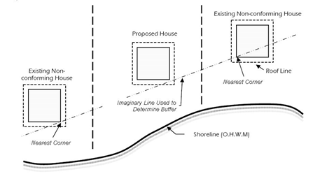
Figure 18.25.270(2)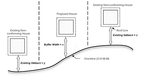
Figure 18.25.270(3)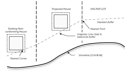
Figure 18.25.270(4)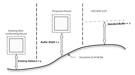
(c) Nonconforming Lots – Development Requiring a Variance. Development on nonconforming lots that do not meet the requirements of subsection (5)(a) or (b) of this section require a shoreline variance.
(d) Water-Oriented Uses/Development. When otherwise consistent with this program and Chapter 18.22 JCC, the following water-oriented uses/developments may be permitted within a shoreline buffer without a shoreline variance. The amount and extent of buffer modification shall be the minimum needed to accommodate the allowed use/development. This allowance for water-oriented uses/developments within shoreline buffers without a shoreline variance may apply to the primary use and/or to the following accessory uses/structures:
(i) Primary uses and structures that meet the definition of a water-dependent or water-related use/development as defined in Article II of this chapter.
(ii) Boating facilities accessory to a single-family residential development including rails, docks, piers and floats;
(iii) Boathouses accessory to a single-family residential development; provided, that all of the following are met:
(A) The boathouse is used to store watercraft and shall not be used as or converted to a dwelling unit. The county shall require a notice on title indicating such; and
(B) The boathouse has a maximum footprint of 300 square feet and a maximum height of 15 feet above average grade; and
(C) The primary doorway/entryway faces the water; and
(D) The structure is located entirely landward of the ordinary high water mark.
(iv) Public or private beach access structures accessory to residential, commercial, industrial, port or other allowed uses/development; and
(v) Public access structures, including but not limited to docks, piers, floats; and
(vi) Certain utilities and essential public facilities as specified in JCC 18.25.530. [Ord. 7-13 Exh. A (Art. VI § 1)]
18.25.280 Historic, archaeological, cultural, scientific and educational resources.
(1) Policies.
(a) Historic, archaeological, cultural, scientific and educational (HACSE) sites and resources should be protected, preserved, and where possible, restored. All use and development on sites containing HACSE resources should be planned and carried out so as to prevent adverse impacts to the resource(s).
(b) To prevent adverse impacts on HACSE resources, proponents of all new shoreline use and development should consult the county department of community development prior to beginning any project or activity.
(c) Tribal, federal, state, educational institutions and local governments should cooperate to maintain an inventory of all known significant local HACSE sites and resources.
(d) The location of historic, cultural and/or archaeological sites/resources should not be disclosed to the general public, consistent with applicable state and federal laws.
(e) When HACSE sites/resources occur on public lands they should be accessible to the public and used for research or educational purposes consistent with the public access provisions of this program and applicable tribal access policies. Private owners of HACSE sites/resources are encouraged to provide access and educational opportunities when appropriate.
(f) If development is proposed adjacent to an identified HACSE site/resource, then the proposed development should be designed and operated so as to be compatible with continued protection of the site/resource.
(2) Regulations – General Regulations.
(a) Proponents of new shoreline use and development, including preferred uses and uses exempt from permit requirements, shall:
(i) Preserve and protect historic, archaeological and cultural resources that are recorded by the Washington State Department of Archaeology and Historic Preservation and resources that are inadvertently discovered during use or development activities; and
(ii) Consult the county department of community development, the Washington State Department of Archaeology and Historic Preservation, affected tribes, and/or other appropriate agencies prior to beginning development so there is ample time to assess the site and make arrangements to preserve historical, cultural and archaeological resources; and
(iii) Comply with all state and federal regulations pertaining to archaeological sites.
(b) All feasible means shall be employed to ensure that data, structures, and sites having historical, archaeological, cultural, scientific, or educational significance are preserved, extracted, or used in a manner commensurate with their importance.
(c) Excavations for archaeological investigations or data recovery may be permitted subject to the provisions of this program.
(d) The county shall prohibit any use or development that poses a threat to a HACSE resource. Alternatively the county shall require the development to be postponed to allow for:
(i) Coordination with potentially affected tribes and/or the State Department of Archaeology and Historic Preservation; and/or
(ii) Investigation of public acquisition potential; and/or
(iii) Retrieval and preservation of significant artifacts.
(3) Regulations – Procedural Requirements.
(a) When the county receives a permit application or request for a statement of exemption for development on a property within 500 feet of a known or probable historic, archaeological, or cultural site, the county shall:
(i) Notify and inform affected tribes and agencies such as the State Department of Archaeology and Historic Preservation of the proposed activity including timing, location, scope, and resources affected; and
(ii) Require the applicant to provide a cultural resource site assessment prior to development unless the administrator determines that the proposed development activities do not include any ground disturbing activities and will not impact a known HACSE site/resource.
(b) If a cultural resource site assessment identifies the presence of significant historic or archaeological resources, a cultural resource management plan (CRMP) shall be required. The plan shall include:
(i) An analysis of actions to be taken by the property owner, developer, archaeologist, or historic preservation professional, in the event that an inadvertent discovery of historic, archaeological, or cultural sites or artifacts occurs during site development; and
(ii) An explanation of why the proposed activity requires a location on, or access across and/or through, a significant historic or archaeological resource; and
(iii) A description of the historic/archaeological resources affected by the proposal; and
(iv) An assessment of the historic/archaeological resource and an analysis of the potential adverse impacts as a result of the activity; and
(v) Recommended measures to prevent adverse impacts; and
(vi) Comments from the Washington State Department of Archaeology and Historic Preservation, and affected tribes.
(c) Site assessments and CRMPs required by this section shall be prepared by a professional archaeologist or historic preservation professional, as applicable. The landowner or project proponent shall be responsible for any professional service fees.
(d) The administrator may reject or request revision of the conclusions reached in a CRMP when she/he can demonstrate that the assessment is inaccurate or does not fully address the management concerns involved.
(e) Where public access is provided to any private or publicly owned building or structure of historic, archaeological or cultural significance, a public access management plan shall be developed in consultation with the Washington State Department of Archaeology and Historic Preservation, affected tribes and/or other agencies, to address the following:
(i) The type and/or level of public access that is consistent with the long-term protection of both historic resource values and shoreline ecological functions and processes; and
(ii) Types and location of interpretative signs, displays and other educational materials; and
(iii) Site- and resource-specific conditions, including hours of operation, interpretive and/or directional signage, lighting, pedestrian access, and/or traffic and parking.
(f) If any phenomena of possible historic, archaeological and/or cultural interest are inadvertently discovered during any new shoreline use or development, the proponent shall immediately stop work and comply with all of the following:
(i) Notify the county department of community development, Washington State Department of Archaeology and Historic Preservation, affected tribes, and other appropriate agencies;
(ii) Prepare a site assessment pursuant to this section to determine the significance of the discovery and the extent of damage to the resource;
(iii) Distribute the site assessment to the Washington State Department of Archaeology and Historic Preservation and affected tribes for a 30-day review to determine the significance of the discovery;
(iv) Maintain the work stoppage until the county determines that the site is considered significant by the above listed agencies or governments, or if the above listed agencies or governments have failed to respond within the applicable review period following receipt of the site assessment; and
(v) Prepare a CRMP pursuant to this section if the county determines that the site is significant.
(g) Upon inadvertent discovery of human remains, the county sheriff, coroner, and State Department of Archaeology and Historic Preservation (DAHP) must be immediately notified.
(h) In the event that unforeseen factors constituting an emergency as defined in RCW 90.58.030 necessitate rapid action to retrieve or preserve historic, archaeological and/or cultural resources, the project may be exempted from the requirement to obtain a permit. The county shall notify the State Department of Ecology, the State Attorney General’s Office, potentially affected tribes, and the State Department of Archaeology and Historic Preservation of such a waiver within 30 days of such action. [Ord. 7-13 Exh. A (Art. VI § 2)]
18.25.290 Public access.
(1) Policies.
(a) Providing public access to public shorelines is a primary goal of the Shoreline Management Act. Jefferson County actively supports public and private efforts making better use of existing facilities/opportunities. Strategic efforts to find and fund new shoreline public access are encouraged to meet increasing demands by a growing populace. Increasing all types of public access is a priority for the county.
(b) The county should prepare a comprehensive shoreline public access plan in cooperation with appropriate local, state, tribal and nongovernmental agencies/organizations, and the general public.
(c) The county should work with appropriate agencies and individuals to acquire lands that can provide physical access to public waters for public use.
(d) Shoreline development by public entities, such as local governments, port districts, state agencies, and public utility districts, should provide public access as part of each development project, unless such access is shown to be incompatible with this program due to reasons of safety, security, or adverse impacts to shoreline functions and processes.
(e) Shoreline development by private entities should provide public access when the development would either generate a demand for one or more forms of such access, and/or would impair existing legal access opportunities or rights.
(f) Single-family residential developments with four or fewer lots/units should not be required to provide public access.
(g) Public health and safety concerns associated with public access sites should be adequately mitigated and appropriate precautions taken to prevent adverse impacts on shoreline ecological functions and/or processes.
(h) Efforts to implement the public access provisions of this section should be consistent with all relevant constitutional and other legal limitations on regulation of private property.
(i) Public access requirements on privately owned lands should be commensurate with the scale and character of the development and should be reasonable, effective and fair to all affected parties including but not limited to the landowner and the public.
(j) Where feasible, providers of shoreline public access should:
(i) Locate and design public access improvements in a manner that is compatible with the natural shoreline character and avoids adverse impacts to shoreline ecological functions and processes; and
(ii) Ensure public access improvements and amenities are safe, respect individual privacy, and avoid or minimize visual impacts from neighboring properties; and
(iii) Provide maps and orientation information to inform the public of the presence and location of privately held tidelands, especially those adjacent to public access and recreational areas; and
(iv) Incorporate programs, signage and informational kiosks into public access locations, where appropriate, to enhance public education and appreciation of shoreline ecology and areas of historical or cultural significance.
(2) Regulations.
(a) Single-family residential developments consisting of four or fewer residential lots or dwelling units shall not be required to provide public access.
(b) Opportunities to provide visual and/or physical public access shall be considered during the review and conditioning of all proposed commercial and industrial shoreline developments and residential developments involving more than four residential lots or dwelling units.
(c) Physical public access shall be incorporated into all development proposals on public lands, all public and private commercial and industrial uses/developments, and all residential subdivisions of greater than four lots unless the project proponent demonstrates that any of the following conditions exist:
(i) Unavoidable public health or safety hazards exist and cannot be prevented through reasonable means; or
(ii) The use/development has inherent security or cultural sensitivity requirements that cannot be mitigated though reasonable design measures or other solutions; or
(iii) The cost of providing the access, easement or an alternative amenity is disproportionate to the total long-term cost of the proposed development; or
(iv) The public access will cause unacceptable environmental impacts that cannot be mitigated; or
(v) The access would create significant, undue, and unavoidable conflicts with adjacent uses that cannot be mitigated.
(d) To be exempt from the public access requirements in subsection (2)(c) of this section, the project proponent must demonstrate that all feasible alternatives have been considered, including, but not necessarily limited to:
(i) Regulating access through means such as maintaining a gate and/or limiting hours of use; and
(ii) Separating uses and activities (e.g., fences, terracing, use of one-way glazing, hedges, landscaping, etc.).
(e) When physical public access is deemed to be infeasible based on considerations listed in subsection (2)(c) of this section, the proponent shall provide visual access to the shore or provide physical access at an off-site location geographically separated from the proposed use/developmental (e.g., a street end, vista, or trail system).
(f) Public access shall be located and designed to be compatible with the natural shoreline character, to avoid adverse impacts to shoreline ecological functions and processes, and to ensure public safety.
(g) When otherwise consistent with this program, public access structures shall be exempt from the shoreline buffer requirements of this program, meaning that such structures shall be allowed to encroach into the shoreline buffer when necessary to provide physical and/or visual access to the water’s edge.
(h) Public shoreline access provided by public road ends, public road rights-of-way, public utilities and rights-of-way shall not be diminished by the county, neighboring property owners, or other citizens, unless the property is zoned for industrial uses in accordance with RCW 36.87.130.
(i) Public access sites shall be directly connected to the nearest public street and shall include improvements that conform to the requirements of the Americans with Disabilities Act (ADA) when feasible and appropriate.
(j) Opportunities for boat-in public access and access to primitive shorelines not accessible by automobile shall be provided where feasible and appropriate.
(k) When required for public land, commercial, port or industrial use/development as per subsections (2)(b) and (c) of this section, public access sites shall be fully developed and available for public use prior to final occupancy of such use or development.
(l) Public access easements and permit conditions shall be recorded on the deed of title and/or the face of a short or long plat as a condition running, at a minimum, for a period contemporaneous with the duration of the authorized land use. Recordation shall occur at the time of final plat approval or prior to final occupancy.
(m) The location of new public access sites shall be clearly identified. Signs with the appropriate agency’s logo shall be constructed, installed and maintained by the project proponent in conspicuous locations at public access sites and/or along common routes to public access sites. The signs shall indicate the public’s right of access, the hours of access, and other information as needed to control or limit access according to conditions of approval. [Ord. 7-13 Exh. A (Art. VI § 3)]
18.25.300 Shoreline setbacks and height.
(1) Policies.
(a) Standards for density, setbacks, height, and other provisions should ensure no net loss of shoreline ecological functions and/or processes and preserve the existing character of the shoreline consistent with the purpose of the applicable shoreline environment designation.
(b) Proponents of a development on no-bank or low bank marine shorelines are encouraged to locate the bottom of a structure’s foundation higher than the level of expected future sea-level rise.
(2) Regulations.
(a) A building setback of 10 feet shall be established on the landward edge of the shoreline buffers required by this program.
(b) Sideyard setbacks shall be measured from all property lines that intersect the shoreline side of a lot or tract. Five feet of the total required sideyard setbacks may be provided on one side and the balance on the other side.
(c) Pursuant to RCW 90.58.320, no permit may be issued for any new or expanded building or structure more than 35 feet above average grade level when such a height will obstruct the view of a substantial number of residences on or adjoining such shorelines. Height is measured according to the definition in Article II of this chapter. The project proponent shall be responsible for providing sufficient information to the administrator to determine that such development will not obstruct views as described.
(d) Power poles and transmission towers associated with allowed uses and developments are not subject to height limits but shall not be higher than necessary to achieve the intended purpose. [Ord. 7-13 Exh. A (Art. VI § 4)]
18.25.310 Vegetation conservation.
(1) Policies.
(a) Maintaining native shoreline vegetation is an important goal of this program. The policies and regulations of this section are intended to ensure well-vegetated, stable shorelines that provide habitat and other ecological benefits and resemble natural, unaltered shorelines.
(b) New uses and/or developments should be designed to preserve native shoreline vegetation to maintain shoreline ecological functions and processes and prevent direct, indirect and/or cumulative impacts of shoreline development.
(c) New uses and/or developments should establish native shoreline vegetation such that the composition, structure, and density of the plant community resemble a natural, unaltered shoreline as much as possible.
(d) Maintaining well-vegetated shorelines is preferred over clearing vegetation to create views or provide lawns. Limited and selective clearing for views and lawns may be allowed when slope stability and ecological functions are not compromised, but landowners should not assume that an unobstructed view of the water is guaranteed. Trimming and pruning are generally preferred over removal of native vegetation. Property owners are strongly encouraged to avoid or minimize the use of fertilizers, herbicides and pesticides.
(e) Shoreline landowners are encouraged to preserve and enhance native woody vegetation and native groundcovers to stabilize soils and provide habitat. Maintaining native plant communities is preferred over nonnative ornamental plantings because native plants have greater ecological value. Nonnative vegetation that requires use of fertilizers, herbicides and/or pesticides is discouraged.
(f) Prior to granting a shoreline permit or determining that a proposed use/development is exempt from permitting, the county should evaluate site plans to determine the extent to which the vegetation is conserved. As needed, the county may require special reports regarding vegetation and shall condition approval of new developments to ensure the following:
(i) Native plant communities on marine, river, and lake shorelines are preserved; and
(ii) Overhanging trees along shorelines are kept intact to provide shading and other ecological functions; and
(iii) Established areas of native plants are preserved to maintain slope stability and prevent surface erosion; and
(iv) Structures and associated development are placed in areas that avoid disturbance of established native plants, especially trees and shrubs; and
(v) Clearing and grading near bluff edges and other erosion- or landslide-prone areas are minimized to prevent slope instability; and
(vi) Shoreline development proposals should incorporate provisions for removing invasive or nonnative species and planting native species when doing so would improve ecological functions and processes.
(2) Regulations.
(a) Unless otherwise specified, all shoreline use and development, including preferred uses and uses exempt from permit requirements, shall comply with the buffer provisions of this program and Chapter 18.22 JCC to protect and maintain shoreline vegetation.
(b) Proponents of all new shoreline uses or developments shall demonstrate that site designs and layouts are consistent with the policies of this section to ensure shoreline functions, values, and processes are maintained and preserved. A shoreline permit or written statement of exemption shall not mandate, nor guarantee, unobstructed horizontal or lateral visibility of the water, shoreline or any specific feature near or far.
(c) View Maintenance. Proponents of all new shoreline uses or developments shall use all feasible techniques to maximize retention of existing native shoreline vegetation while allowing for shoreline views.
(i) Vegetation Trimming. Techniques shall include selective pruning, windowing and other measures that preserve native plant composition and structure. No more than 25 percent of a single tree’s leaf bearing crown may be removed and no more than 25 percent of the canopy cover of any stand of trees may be removed for view preservation. If additional trimming is requested in subsequent years, the cumulative removal may not exceed 25 percent. Limbing or crown thinning shall comply with Tree Care Industry Association pruning standards, unless the tree is a hazard tree as defined by this program. Tree topping is prohibited when main stem/trunk is over three inches diameter at breast height (DBH).
(ii) Vegetation Removal. All vegetation removal within the buffer area must comply with JCC 18.25.270(4)(h). In no instance shall vegetation removal exceed 20 percent of the required buffer area or 15 linear feet of the water frontage, whichever is greater. Outside the buffer, vegetation removal shall be the minimum necessary for maintaining shoreline views from the primary structure and to provide lawns or ground cover, and must comply with other applicable requirements such as clearing and grading, forest practices, and protection standards for fish and wildlife habitat.
(iii) The administrator may deny a request or condition approval of vegetation management proposals for view maintenance if it is determined the action will result in an adverse effect to any of the following:
(A) Slope stability;
(B) Habitat value;
(C) Health of surrounding vegetation;
(D) Risk of wind damage to surrounding vegetation;
(E) Nearby surface or ground water; or
(F) Water quality of a nearby water body.
(d) Proponents of all new shoreline uses or developments shall maintain existing native shoreline vegetation to the maximum extent practicable, except that the following activities shall be exempt from this requirement:
(i) Existing and ongoing agricultural activities on agricultural lands enrolled in the open space tax program for agriculture or on lands designated as agricultural lands of long-term commercial significance on the official map of Comprehensive Plan land use designations;
(ii) Buffer enhancement by removal of noxious weeds, based on consultation with the Jefferson County noxious weed board, and/or planting native vegetation;
(iii) Maintenance of existing residential landscaping, such as lawns and gardens, pursuant to JCC 18.22.230(4)(m);
(iv) Maintenance trimming of the limbs or branches on a tree or shrub that has a main stem less than three inches in diameter at breast height (DBH);
(v) Construction of pervious surface trails for nonmotorized use, provided the trail is no wider than five feet and the vegetation trimming is limited to five feet on either side of the trail except where an arborist report indicates that additional vegetation trimming or removal is required for safety reasons;
(vi) Harvest of wild crops that does not significantly affect the viability of the wild crop, or adversely affect shoreline functions of the area;
(vii) Removal of a hazard tree, as defined in Article II of this chapter, where trimming is not sufficient to address the hazard. In such cases, the downed tree shall be retained on site to provide wildlife habitat and enhance in-stream or marine habitat if present. The location of retained materials placed on site shall reflect firewise program guidance for defensible space and fire safety. Where not immediately apparent to the administrator, the hazard tree determination shall be made after review of a report prepared by an arborist or forester.
(e) The county may impose conditions on new shoreline use and/or development as needed to prevent the introduction and spread of aquatic weeds. Aquatic weed removal and disposal shall occur in a manner that minimizes and mitigates adverse impacts to native plant communities and shoreline ecological functions.
(f) When restoring or enhancing shoreline vegetation, proponents shall use native species approved by the county that are of a similar diversity, density, and type to that occurring in the general vicinity of the site prior to any shoreline alteration. The vegetation shall be nurtured and maintained to ensure establishment of a healthy and sustainable native plant community over time.
(g) The vegetation conservation regulations of this program do not apply to commercial forest practices as defined by Article II of this chapter when such activities are covered under the Washington State Forest Practices Act (Chapter 76.09 RCW). Where such activities are associated with a conversion of forest lands to other uses or other forest practice activities, the vegetation conservation requirements shall apply.
(h) Vegetation conservation standards shall not apply retroactively to existing uses and developments, although property owners are strongly encouraged to voluntarily improve shoreline vegetation conditions over the long term.
(i) Vegetative debris shall be properly managed by mulching/leaving in place as habitat and soil amendment, composting on-site, or removing and disposing of off-site. The dumping of vegetative debris, including grass clippings and yard waste, in shoreline areas is strongly discouraged, especially when slope stability and water quality would be threatened.
(j) Vegetative debris in the buffer that creates a fire hazard to existing structures may be reduced by chipping if the chipped material is returned to the original location. Fallen tree trunks may not be removed or chipped. [Ord. 7-13 Exh. A (Art. VI § 5)]
18.25.320 Water quality and quantity.
(1) Policies.
(a) The location, construction, operation, and maintenance of all shoreline uses and developments should maintain or enhance the quantity and quality of surface and ground water over the long term.
(b) Shoreline use and development should minimize, through effective education, site planning and maintenance, the need for chemical fertilizers, pesticides, herbicides or other similar chemical treatments that could contaminate surface or ground water or cause adverse effects on shoreline ecological functions and values.
(c) Appropriate buffers along all wetlands, streams, lakes, and marine water bodies should be provided and maintained in a manner that avoids the need for chemical treatment.
(d) Potential adverse effects of agricultural activities on water quality should be minimized by implementing best management practices, buffers and other appropriate measures.
(e) Effective erosion control and water-runoff treatment methods should be provided for all shoreline development and use in accordance with JCC 18.30.070.
(f) Encourage pervious materials and other appropriate low impact development techniques where soils and geologic conditions are suitable and where such practices could reduce stormwater runoff.
(2) Regulations.
(a) All shoreline uses and activities shall use effective erosion control methods during both project construction and operation. At a minimum, effective erosion control methods shall require compliance with the current edition of the Department of Ecology’s Stormwater Management Manual, NPDES General Permit requirements, and the stormwater management provisions of JCC 18.30.070.
(b) To avoid water quality degradation by malfunctioning or failing septic systems located within shoreline jurisdiction, on-site sewage systems shall be located and designed to meet all applicable water quality, utility, and health standards.
(c) All materials that may come in contact with water shall be composed of nontoxic materials, such as wood, concrete, approved plastic composites or steel, that will not adversely affect water quality or aquatic plants or animals. Materials used for decking or other structural components shall be approved by applicable state agencies for contact with water to avoid discharge of pollutants from wave splash, rain, or runoff. Wood treated with creosote, copper chromium arsenate or pentachlorophenol is prohibited in shoreline water bodies.
(d) Solid and liquid wastes and untreated effluents shall not be allowed to enter any ground water or surface water or to be discharged onto land. The release of oil, chemicals, genetically modified organisms or hazardous materials onto land or into the water is prohibited. [Ord. 7-13 Exh. A (Art. VI § 6)]
Article VII. Shoreline Modifications Policies and Regulations
18.25.330 Applicability – Purpose.
The policies and regulations in this article apply to all types of shoreline modification, with specific standards defined for each shoreline environment. They are not listed in order of priority. These policies and regulations:
(1) Help to implement the master program goals in Article III of this chapter; and
(2) Are informed by the guiding principles in Article I of this chapter; and
(3) Work in concert with all the other policies and regulations contained in this program; and
(4) Are based on the state shoreline guidelines (Chapter 173-26 WAC). [Ord. 7-13 Exh. A (Art. VII)]
18.25.340 Beach access structures.
(1) Policies.
(a) Beach access structures, as defined in Article II of this chapter, should be located, designed and maintained in a manner that minimizes adverse effects on shoreline ecology.
(b) Jefferson County recognizes a balance has to be found between enabling pedestrian access to beach areas and protecting fragile shoreline ecosystems.
(c) Neighboring property owners are encouraged to combine resources to collectively propose beach access structures in appropriate locations for shared use.
(d) Beach access structures should not be permitted until and unless their adverse effects on stream, lake or marine shoreline functions and processes, including any significant adverse effects on adjoining lands and properties, are fully evaluated and mitigated. All proposals for structures that link upland areas with adjacent beaches shall be carefully evaluated by the criteria and regulations in this section.
(e) Beach access structures may not be appropriate in some areas because of safety hazards or sensitive ecological conditions. The county should not permit these structures in areas where there are expected risks to human health and safety or adverse effects on shoreline functions and processes. Some properties will have view-only access to the neighboring waters.
(f) Beach access structures should conform to the existing topography, minimize adverse impacts on shoreline aesthetics, and minimize clearing and grading to the maximum extent feasible.
(g) Beach access structures should not be allowed if there is a reasonable likelihood that they will require erosion control structures or armoring in the future.
(h) Beach access structures should be designed to minimize the amount of clearing, grading, excavation, and other forms of shoreline alteration so that they don’t require substantial bank or slope modifications.
(i) Beach access structures should only be allowed where it provides access to a publicly owned beach or where the same party owns both the uplands and adjoining tidelands or an easement is granted by the tideland owner to the upland owner for access.
(2) Uses and Activities Prohibited Outright. Beach access structures shall be prohibited from marine feeder bluffs in all environment designations.
(3) Shoreline Environment Regulations.
(a) Priority Aquatic. Public beach access structures may be permitted as a conditional use, provided they are associated with a water-dependent use that includes public access to the shoreline, and provided they are consistent with policies and regulations of this program and are allowed in the adjoining upland designation. Private beach access structures accessory to single-family residential development shall be prohibited.
(b) Aquatic. Public beach access structures may be permitted as a conditional use, provided they are associated with a water-dependent use that includes public access to the shoreline, and provided they are consistent with policies and regulations of this program in the adjoining upland designation. Private beach access structures accessory to single-family residential development may be permitted as a conditional use when they are allowed in the adjoining upland designation.
(c) Natural. Public beach access structures may be permitted as a conditional use, provided they are associated with a water-dependent use that includes public access to the shoreline, and provided they are consistent with policies and regulations of this program. Private beach access structures accessory to single-family residential development shall be prohibited.
(d) Conservancy. Public and private beach access structures may be permitted as a conditional use, provided they are consistent with the provisions of this program.
(e) Shoreline Residential. Public and private beach access structures may be permitted as a conditional use, provided they are consistent with the provisions of this program.
(f) High Intensity. Public and private beach access structures may be permitted as a conditional use, provided they are consistent with the provisions of this program.
(4) Regulations.
(a) Beach access structures may be permitted only when consistent with the provisions of this program.
(b) Public beach access structures shall be subject to this section, JCC 18.25.290 (Public access) of this program, and conform to Americans with Disabilities Act (ADA) standards.
(c) When permitted, beach access structures shall be located, designed and operated to avoid critical areas and prevent a net loss of shoreline ecological functions or processes, including, but not limited to:
(i) Habitat;
(ii) Slope stability;
(iii) Sediment transport; and
(iv) Water quality.
(d) The county shall have the authority to require specific design standards based on the configuration of the site including existing topography, vegetation, soils, drainage and other factors.
(e) When allowed, beach access structures may be located within the shoreline buffer; provided, that:
(i) The clear width of any walkway, staircase, tower or tram shall be at least three feet, and not exceed five feet; and
(ii) The structure shall not extend more than 12 vertical feet above the bank or slope; and
(iii) There is no other available public beach access within 500 feet of the proposed access site.
(f) No portion of a beach access structure shall be constructed waterward of the ordinary high water mark unless there is no other feasible alternative.
(g) When in-water or over-water construction is allowed in accordance with this section it shall be limited to a small pier or pile-supported pedestrian landing platform of 25 square feet or less that is otherwise consistent with the provisions of this program.
(h) New residential subdivisions of more than four units or lots shall include a restriction on the face of the plat prohibiting individual beach access structures. Shared access structures may be permitted in these subdivisions when consistent with the provisions of this program.
(i) Existing lawfully constructed nonconforming beach access structures may be repaired or replaced in kind as a nonconforming use as consistent with other provisions of this program.
(j) Beach access structures shall be prohibited if any of the following apply:
(i) The structure would adversely impact a critical area or marine feeder bluff, or increase landslide or erosion hazards; or
(ii) The structure is likely to interfere with natural erosion and accretion processes; or
(iii) The bank slope where the structure is placed is likely to require shoreline stabilization/shoreline defense works in the future; or
(iv) Substantial bank or slope modification is required.
(k) Prior to approving a permit for a beach access structure, the county shall require the project proponent to demonstrate that the project is consistent with this program. Information to be provided by the proponent will include, but not be limited to:
(i) Existing conditions at the site related to erosion, slope stability, drainage, vegetation, and coastal processes; and
(ii) Probable effects of the access structure on the stability of the site over time; and
(iii) Potential effects of the access structure on shoreline processes such as net-shoreline drift, sediment transport, mass wasting, and erosion; and
(iv) Methods for maintaining the structure over time that will preclude the need for a bulkhead or other type of stabilization in the future; and
(v) Potential effects on fish and wildlife habitats and other shoreline ecological functions; and
(vi) Measures needed to ensure/maintain slope stability, maintain coastal processes, and prevent erosion in the long term.
(l) The county may require proposals for pedestrian beach access structures to include geotechnical analysis prepared by a licensed professional engineer or geologist and/or biological analysis prepared by a qualified biologist. [Ord. 7-13 Exh. A (Art. VII § 1)]
18.25.350 Boating facilities – Boat launches, docks, piers, floats, lifts, marinas, and mooring buoys.
(1) Policies.
(a) Boating facilities as defined in Article II of this chapter should be located, designed, constructed and operated with appropriate mitigation to avoid adverse effects on shoreline functions and processes and to prevent conflicts with other allowed uses.
(b) Boating facilities should not be located or expanded where they would:
(i) Impact critical habitats; or
(ii) Substantially interfere with currents and/or net-shoreline drift; or
(iii) Cause significant adverse effects on aquatic habitat, biological functions, water quality, aesthetics, navigation, and/or neighboring uses.
(c) Docks and piers should not be allowed where shallow depths require excessive overwater length.
(d) The county should protect the natural character of the shoreline and prevent adverse ecological impacts caused by in-water and overwater structures by limiting the number of new docks/piers/floats and by controlling how they are designed and constructed and where they are located. Wood coated or treated with toxic materials should not be allowed.
(e) To prevent the impacts associated with private docks, piers, floats, lifts and launch ramps and rails accessory to residential development:
(i) Mooring buoys are generally preferred over docks, piers or floats; and
(ii) Shared docks/piers/floats serving multiple properties are preferred over single-user docks/piers/floats serving a single property or parcel; and
(iii) Public boat launches are preferred over private launch facilities. Rail and track launch systems are preferred over ramps.
(f) Boating facilities associated with commercial, industrial, or port uses, residential subdivisions and multifamily housing should include public access and contribute to the public’s ability to view, touch, and travel on the waters of the state in accordance with JCC 18.25.290 (Public access).
(g) The county should identify areas that are suitable for development and/or expansion of marinas and public boat launches and prevent them from being developed with non-water-dependent uses having less stringent site requirements. This should be accomplished in a timely manner.
(h) Development of new marinas and public boat launch facilities should be coordinated with public access and recreation plans and should be co-located with port or other compatible water-dependent uses where feasible. Affected parties and potential partners should be included in the planning process.
(i) When reviewing proposals for new or expanded marinas and public boat launches, the county should seek comment from public recreation providers, adjacent cities/counties, port districts, Washington State Parks, and the Washington State Departments of Ecology, Fish and Wildlife, Health, and Natural Resources, and area tribes to ensure that local as well as regional recreation needs are addressed.
(j) The county should support the use of innovative and effective methods for protecting, enhancing, and restoring shoreline ecological functions and processes during the design, development and operation of new or expanded boating facilities. Such methods may include public facility and resource planning, education, voluntary protection and enhancement projects, and incentive programs.
(2) Shoreline Environment Regulations.
(a) Priority Aquatic.
(i) Boat Launches – Nonresidential. Only public and private launches serving water-dependent commercial, industrial, port or other primary uses may be permitted if the primary use is permitted in the adjacent upland shoreline environment subject to the provisions of this program.
(ii) Docks, Piers, Floats and Lifts – Nonresidential. Only public and private docks, piers, floats and lifts serving water-dependent commercial, industrial, port or other primary uses are allowed subject to policies and regulations of this program if the primary use is permitted in the adjacent upland shoreline environment.
(iii) Boat Launches, Docks, Piers, Floats, and Lifts – Residential. Single-user docks, piers, floats, lifts and boat launches accessory to residential or private recreational development are prohibited. Shared boating facilities accessory to residential or private recreational development may be permitted.
(iv) Marinas are prohibited.
(v) Moorage used for float planes is prohibited.
(vi) Mooring buoys are allowed subject to the adjacent upland shoreline designation and the policies and regulations of this program.
(b) Aquatic.
(i) Public and private boat launches are allowed subject to policies and regulations of this program if allowed in the adjacent upland shoreline environment.
(ii) Public and private docks, piers, floats, and lifts are allowed if allowed in the adjacent upland shoreline environment.
(iii) Marinas are allowed subject to policies and regulations of this program if allowed in the adjacent upland shoreline environment.
(iv) Moorage used for float planes may be allowed with a conditional use permit if permitted in the adjacent upland designation.
(v) Mooring buoys are allowed subject to the adjacent upland shoreline designation and the policies and regulations of this program.
(c) Natural.
(i) Boat launches for hand launching of small watercraft (such as kayaks, small sailboats, and other nonmotorized watercraft) may be allowed with a conditional use permit, subject to policies and regulations of this program, if materials and design are compatible with the site.
(ii) A public dock, pier or float for recreational use may be allowed with a conditional use permit.
(iii) Mooring buoys that are accessory to water-dependent uses such as aquaculture may be allowed with a conditional use permit (C(a)).
(iv) All other boating facilities, including boating facilities accessory to residential development, are prohibited.
(d) Conservancy.
(i) Boat launches may be allowed with a conditional use permit subject to policies and regulations of this program.
(ii) Docks, piers, floats and lifts may be allowed with a conditional use permit subject to policies and regulations of this program, except industrial piers are prohibited.
(iii) Marinas may be permitted as a conditional use.
(iv) Moorage used for float planes may be permitted as a conditional use.
(v) Mooring buoys are allowed with a conditional use permit (C(a)) subject to policies and regulations of this program.
(e) Shoreline Residential.
(i) Boat launches are allowed subject to policies and regulations of this program.
(ii) Docks, piers, floats and lifts are allowed subject to policies and regulations of this program, except industrial piers are prohibited.
(iii) Marinas may be permitted as a conditional use.
(iv) Moorage used for float planes may be permitted as a conditional use.
(v) Mooring buoys are allowed with a conditional use permit (C(a)) subject to policies and regulations of this program.
(f) High Intensity. All boating facilities are allowed subject to policies and regulations of this program.
(3) Regulations – Boat Launches – Public.
(a) Public boat launches may be permitted when they are located, designed and constructed in a manner that minimizes adverse impacts on coastal or fluvial processes, biological functions, aquatic and riparian habitats, water quality, navigation, and/or neighboring uses. Rail and track systems shall be preferred over concrete ramps or similar facilities.
(b) When permitted, public boat launches shall be:
(i) Located in areas where there is adequate water mixing and flushing action;
(ii) Designed so as not to retard or reduce natural shoreline flushing characteristics;
(iii) Designed and constructed using methods/technology that have been recognized and approved by state and federal resource agencies as the best currently available;
(iv) Designed so that existing or potential public access along beaches is not blocked or made unsafe, and so that public use of the surface waters is not unduly impaired; and
(v) Developed and maintained to support waterfront access for watercraft. In those limited instances where separate or associated uses are permitted, other than restrooms and/or sewer/septic facilities, only uses that are water-dependent and/or afford public access uses shall be approved.
(c) Public boat launches on river shores shall be located downstream of accretion shoreforms, or on stable banks where no or minimal current deflections will be necessary.
(d) Public boat launches shall provide adequate restroom and sewage and solid waste disposal facilities in compliance with applicable health regulations.
(e) When overwater development is proposed in association with a public boat launch facility, it may be permitted only where such use requires direct water access, and/or where such facilities will significantly increase public opportunities for water access.
(f) Public boat launches shall be located and designed to prevent traffic hazards and minimize traffic impacts on nearby access streets.
(g) Public boat launch sites shall include parking spaces for boat trailers commensurate with projected demand and shall comply with the transportation provisions of this program.
(4) Regulations – Boat Launches (Ramps and Rails) – Private.
(a) Private boat launches shall be allowed only when public boat launches are unavailable within a reasonable distance.
(b) When permitted, private boat launches including launches accessory to residential development shall be designed and constructed using methods/technology that have been recognized and approved by state and federal resource agencies as the best currently available. Rail and track systems shall be preferred over concrete ramps or similar facilities.
(c) No more than one private boat launch facility or structure shall be permitted on a single parcel or residential lot.
(5) Regulations – Docks, Piers and Floats – Nonresidential.
(a) Docks, piers and floats, as defined in Article II of this chapter, associated with commercial, industrial, port or public recreational developments should only be allowed when ecological impacts are mitigated in accordance with this program, and:
(i) The dock/pier/float is required to accommodate a water-dependent use; and/or
(ii) The dock/pier/float provides opportunities for the public to access the shoreline.
(b) New commercial, industrial, port or public recreational docks, piers and floats shall be designed and constructed to avoid or, if that is not possible, to minimize the impacts to nearshore habitats and processes.
(c) The length, width and height of nonresidential docks, piers and floats shall be no greater than that required for safety and practicality for the primary use.
(d) New and substantially expanded nonresidential docks, piers and floats shall be constructed of materials that will not adversely affect water quality or aquatic plants and animals over the long term. Materials for any portions of the dock, pier, float, framing, or decking that come in contact with water shall be approved by applicable state agencies for use in water. For example, wood treated with creosote, pentachlorophenol or other similarly toxic materials is not allowed.
(e) To minimize adverse effects on nearshore habitats and species caused by overwater structures that reduce ambient light levels, the following shall apply:
(i) The width of docks, piers and floats shall be the minimum necessary. Materials that will allow light to pass through the deck may be required where width exceeds four feet; and
(ii) Grating to allow light passage or reflective panels to increase light refraction shall be used on walkways or gangplanks in nearshore areas; and
(iii) The maximum structure height above water shall be employed, consistent with safety and usability.
(f) Commercial, industrial, port or public recreational docks, piers and floats shall be spaced and oriented to shoreline in a manner that avoids or minimizes:
(i) Hazards and obstructions to navigation, fishing, swimming and pleasure boating; and
(ii) Shading of beach substrate below; and
(iii) Any “wall” effect that would block or baffle wave patterns, currents, littoral drift, or movement of aquatic life forms. A north-south orientation is generally optimal.
(g) Fill waterward of OHWM shall be limited to the minimum necessary to match the upland with the elevation of the nonresidential dock or pier when consistent with JCC 18.25.370 (Filling and excavation).
(h) Dredging shall be limited to the minimum necessary to allow boat access to a nonresidential dock or pier when consistent with JCC 18.25.360 (Dredging).
(i) Covered moorage associated with nonresidential docks, piers, and floats shall be prohibited.
(6) Regulations – Docks, Piers, Floats and Lifts – Accessory to Residential Development.
(a) Docks, piers, floats and lifts accessory to residential development/use shall only be allowed when:
(i) Ecological impacts are mitigated in accordance with this program; and
(ii) The moorage platform is designed for access to private watercraft; and
(iii) The cumulative effects of dock, pier, float and lift proliferation have been identified and shown to be negligible.
(b) If allowed under this program, no more than one dock/pier and one float and one boat/ski lift may be permitted on a single lot owned for residential use or private recreational use.
(c) In-water fixed platform structures supported by piles that do not abut the shoreline shall be prohibited.
(d) If permitted, new docks, piers, floats, lifts accessory to residential development/use shall be:
(i) Designed and constructed to avoid or, if that is not possible, to minimize shading and other impacts on nearshore habitats and processes; and
(ii) Constructed of materials that will not adversely affect water quality or aquatic plants and animals over the long term. Materials for portions of the dock, pier, float, framing and decking in contact with water shall be approved by applicable state agencies for use in water. For example, wood treated with creosote, pentachlorophenol or other similarly toxic materials is not allowed; and
(iii) Spaced and oriented to shoreline in a manner that minimizes hazards and obstructions to navigation, fishing, swimming, and pleasure boating; and
(iv) Designed to avoid the need for maintenance dredging. The moorage of a boat larger than provided for in original moorage design shall not be grounds for approval of dredging; and
(v) Spaced and oriented to minimize shading and avoid a “wall” effect that would block or baffle wave patterns, currents, littoral drift, or movement of aquatic life forms. A north-south orientation is generally optimal.
(e) The length of docks and piers accessory to residential use/development shall be the minimum demonstrated necessary for safety and practicality for the residential use. The maximum length for residential docks or piers shall be limited to 100 feet as measured horizontally from the ordinary high water mark.
The administrator may approve a different dock or pier length when needed to:
(i) Avoid known eelgrass beds, forage fish habitats, or other sensitive nearshore resources; or
(ii) Accommodate shared use.
(f) Floats accessory to residential use shall not exceed 200 square feet in area or three feet in height as measured from the mean lower low water (MLLW).
(g) Floats shall only be used where there is sufficient water depth to prevent grounding at low tide. The county may require the use of stoppers or other measures to ensure compliance with this standard.
(h) To avoid and minimize adverse effects on nearshore habitats and species caused by overwater structures that reduce ambient light levels, the following shall apply:
(i) The width of docks and floats shall be the minimum necessary. Materials that will allow light to pass through the deck may be required where width exceeds four feet; and
(ii) Grating to allow light passage or reflective panels to increase light refraction shall be used on walkways or gangplanks in nearshore areas; and
(iii) The maximum structure height above water should be employed, consistent with safety and usability.
(i) Residential developments with more than four lots or dwelling units may be granted permits for community docks that are shared by at least one other owner. No more than one dock/pier or float may be permitted for each three adjoining waterfront lots, with necessary access easements to be recorded at the time of permitting.
(j) Single-user docks, piers and floats for individual residential lots may be permitted in existing subdivisions approved on or before January 28, 1993, only where a shared facility has not already been developed. Prior to development of a new single-user dock/pier/float for a single residential lot, the applicant shall demonstrate that:
(i) Existing facilities in the vicinity, including marinas and shared moorage, are not adequate or feasible for use; and
(ii) On marine shorelines alternative moorage, such as one or more mooring buoys or a buoy in combination with a small dock sized to accommodate a tender vessel, are not adequate or feasible.
(k) Single-user moorage for private/recreational float planes may be permitted as a conditional use where construction of such moorage:
(i) Is limited to the smallest size necessary to accommodate the float plane.
(ii) Will not adversely affect shoreline functions or processes, including wildlife use.
(iii) Includes ecological restoration, in addition to mitigation, to compensate for the greater intensity of use associated with the float plane moorage.
(l) Covered moorage associated with single-family residential development shall be prohibited, except that the county may allow a small covered area up to 100 square feet in size, maximum height of 10 feet, and with vertical walls on up to three sides on the overland portion of a dock/pier only.
(m) Single-user docks/piers/floats shall be located within side yard setbacks for residential development (both onshore and offshore); provided, that a shared dock/pier may be located adjacent to or upon a shared side property line upon filing of an agreement by the affected property owners.
(n) Fill waterward of OHWM shall be limited to the minimum necessary to match the upland with the elevation of the residential dock or pier when consistent with JCC 18.25.370 (Filling and excavation).
(o) Dredging for construction or maintenance of docks, piers and floats accessory to residential use shall be prohibited waterward of OHWM.
(p) No single-user or shared dock/pier/float may be constructed to within 200 feet of OHWM on the opposite shoreline of any lake or semi-enclosed body of water such as a bay, cove, or natural channel.
(q) Boating facilities shall be marked with reflectors, or otherwise identified to prevent unnecessarily hazardous conditions for water surface users during day or night. Exterior finish shall be generally nonreflective.
(r) Boating facilities shall be constructed and maintained so that no part of them creates hazardous conditions nor damages other shoreline property or natural features during flood conditions.
(s) No dock, pier, float, or watercraft moored thereto shall be used for a residence.
(t) Storage of fuel, oils, and other toxic materials is prohibited on residential docks, piers and floats except in portable containers that have secondary containment.
(7) Regulations – Marinas.
(a) Marinas may be permitted on marine and river shorelines when they are consistent with this program and when the proponent demonstrates to the county’s satisfaction that all of the following conditions are met:
(i) The proposed location is the least environmentally damaging alternative; and
(ii) Potential adverse impacts on shoreline processes and ecological functions are mitigated to achieve no net loss; and
(iii) The project includes ecological restoration measures to improve baseline conditions over time; and
(iv) The area has adequate water circulation and flushing action; and
(v) The proposed location will not require dredging or excavation/filling of wetlands; and
(vi) Suitable public infrastructure is available or can be made available to support the marina.
(b) Marinas shall be prohibited in all of the following locations:
(i) Lake shores; and
(ii) River point and channel bars or other accretional beaches; and
(iii) Areas of active channel migration; and
(iv) Where a flood hazard will be created or exacerbated; and
(v) Shorelines with a priority aquatic environmental designation; and
(vi) River mouths.
(c) Where marinas are permitted they shall be designed, constructed and operated according to the following:
(i) Open pile or floating breakwater designs shall be used unless the proponent demonstrates that there are specific safety considerations that warrant alternative approaches or unless rip-rap or other solid construction is shown to have fewer impacts on shoreline ecology over the short and long term.
(ii) Shoreline armoring shall be limited to the minimum necessary to protect marina infrastructure and shall consist of softshore bio-stabilization unless such stabilization is demonstrated by a geotechnical analysis to be infeasible or inadequate to protect the site.
(iii) Floating structures shall be designed to prevent grounding on tidelands. Floats shall only be used where there is sufficient water depth to prevent grounding at low tide. The county may require the use of stoppers or other measures to ensure compliance with this standard.
(iv) Piers and other structures shall be located, sized and designed to minimize shading of nearshore aquatic habitats and species.
(v) Solid structures shall be designed to provide fish passage through and along the shallow water fringe.
(vi) Floating piers shall be required in rivers unless the proponent can demonstrate that fixed piers will cause substantially less impact on geo-hydraulic processes.
(vii) Marinas shall be sited to prevent restrictions in the use of commercial and recreational shellfish beds and in compliance with Washington Department of Health guidelines and National Shellfish Sanitation Program (NSSP) standards.
(viii) Marina development shall generally be required to include public access amenities. Consistent with JCC 18.25.290 (Public access), public access siting and design shall be determined based on what is appropriate to a given location and the needs/desires of the surrounding community. Public access shall be designed to be environmentally sound, aesthetically compatible with adjacent uses, and safe for users.
(ix) Live-aboard vessels may occupy up to 20 percent of the slips at a marina. Marinas that accommodate live-aboards shall provide and maintain adequate facilities and programs to address waste disposal and sanitary disposal.
(x) New or expanded marina development may include fill waterward of the ordinary high water mark only when necessary for the water-dependent portions of the marina facility. Such fill activities shall conform to JCC 18.25.370 (Filling and excavation) and this section. Filling solely for the creation of marina parking areas shall be prohibited.
(xi) If new or expanded marina facilities adversely affect net shoreline drift or other coastal processes to the detriment of nearby beaches or habitats, the county may require the marina operator to replenish the substrate in these areas periodically or take other measures to offset adverse impacts.
(d) New or expanded development appurtenant to marinas shall be designed and constructed to avoid and, where avoidance is not possible, minimize impacts on shoreline functions and processes. Facilities shall be clustered and located in the least environmentally damaging portion of the site to reduce clearing and grading impacts.
(e) To meet the regulations in subsection (7)(d) of this section, the following standards shall apply to new or expanded development appurtenant to marinas:
(i) Accessory uses at marinas shall be limited to water-oriented uses and uses that provide physical or visual shoreline access for substantial numbers of the general public. Accessory development includes, but is not limited to, parking, open air storage, waste storage and treatment, stormwater management facilities, utility and upland transportation development.
(ii) Water-oriented accessory uses reasonably related to marina operation may be located over water or near the water’s edge by conditional use permit if an overwater or water’s-edge location is essential to the operation of the use and if opportunities are provided for substantial numbers of people to access the shoreline.
(iii) Parking shall be located away from the water’s edge and landward of shoreline buffers prescribed by this program unless no feasible alternative location exists.
(iv) Parking areas shall meet county stormwater management standards and shall, where feasible, incorporate low impact development practices such as pervious surfaces and bioswales.
(v) Dry moorage and other storage areas shall be landscaped with native vegetation to provide a visual and noise buffer for adjoining uses.
(vi) Pump-out, holding, and/or waste treatment facilities and services shall be provided at all marinas. Pump-out facilities shall be conveniently located and sited to ensure easy access, prevent lengthy queues and allow full compliance with waste disposal regulations. Vessel-mounted pump-out services and hard-plumbed stations at each slip shall be preferred over portable pump-out equipment.
(vii) Marinas shall provide adequate restroom and sewage disposal facilities in compliance with applicable health regulations. Restrooms shall be available 24 hours a day for use by any patron of the marina facility; the need for restrooms shall be determined based on the number of slips and percentage of live-aboard vessels within the marina.
(viii) Garbage and recycling receptacles shall be provided and maintained by the marina operator at several locations convenient to users.
(ix) Marina operators shall post all regulations pertaining to handling and disposal of waste, sewage, fuel, and oil or toxic materials where all users may easily read them.
(x) Boat washing facilities shall be provided to minimize transfer of invasive aquatic species between water bodies.
(f) When reviewing proposals for new or expanded marina facilities, the county shall require the proponent to prepare and implement appropriate technical studies and plans that are not already required via another regulatory review process. Examples of studies and plans that may be required include, but are not limited to:
(i) A maintenance plan for maintaining pump-out and waste/sewage disposal facilities and services.
(ii) A spill response plan for oil and other spilled products. Compliance with federal or state law may fulfill this requirement.
(iii) An operational plan that, at a minimum, describes procedures for fuel handling and storage; measures, including signage, for informing marina users of applicable regulations; measures for collecting garbage and recyclables; measures and equipment for ensuring public safety.
(iv) A visual assessment of views from surrounding residential properties, public viewpoints, and the view of the shoreline from the water surface.
(v) An assessment of existing water-dependent uses in the vicinity including but not limited to, navigation, fishing, shellfish production and harvest, swimming, beach walking, and picnicking and shall document potential impacts and mitigating measures. The county shall evaluate impacts on these resources and impose specific conditions to mitigate impacts as necessary.
(8) Regulations – Mooring Buoys.
(a) Commercial or recreational mooring buoys may be permitted; provided, that they are consistent with this program and that individually or cumulatively:
(i) They do not impede the ability of other landowners to access private property; and
(ii) They do not pose a hazard to or obstruct navigation or fishing; and
(iii) They do not contribute to water quality or habitat degradation; and
(iv) They do not pose a threat to a commercial shellfish growing area classification or reduce the ability to upgrade the classification.
(b) The installation and use of mooring buoys (including commercial and recreational buoys) in marine waters shall be consistent with all applicable state laws, including Chapter 246-282 WAC, the current National Shellfish Sanitation Program (NSSP) standards, and other State Departments of Fish and Wildlife, Health, and/or Natural Resources standards.
(c) Private recreational mooring buoys on state-owned aquatic lands shall not be used for residential (living on the boat) or commercial purposes.
(d) Mooring buoys shall be located to:
(i) Avoid eelgrass beds and other valuable aquatic and nearshore habitat areas; and
(ii) Prevent obstruction to navigation.
(e) Mooring buoys shall use neutral buoyancy rope, mid-line float, helical anchors, or other state-approved designs that have minimal adverse effects on aquatic ecosystem and fish.
(f) Mooring buoys shall not be allowed on lake shorelines of the state.
(g) Mooring buoys shall be clearly marked and labeled with the owner’s name and contact information and permit number(s).
(h) The county shall plan for and coordinate with other agencies to control the placement and number of mooring buoys within bays and other areas to protect water quality and/or habitat and ensure that transit channels are maintained. Under no circumstances shall mooring buoy density exceed State Department of Health guidelines and National Shellfish Sanitation Program (NSSP) standards.
(i) The capacity of each mooring buoy may not exceed one boat and its appurtenant shore access craft. [Ord. 7-13 Exh. A (Art. VII § 2)]
18.25.360 Dredging.
(1) Policies.
(a) Dredging, as defined in Article II of this chapter, and disposal of dredge material should only be allowed when alternatives are infeasible and when the dredging/dredge disposal is:
(i) Necessary to support an existing legal use or a proposed water-dependent use or essential public infrastructure/facility; or
(ii) Part of a clean-up program required under the Model Toxics Control Act or Comprehensive Environmental Response, Compensation, and Liability Act; or
(iii) Part of an approved ecological restoration or enhancement project; or
(iv) Part of an approved beach nourishment project; or
(v) Required to provide public access for a substantial number of people; or
(vi) Required to provide water-oriented public recreation for a substantial number of people.
(b) When required to support an allowed use or development, dredging/dredge disposal should be the minimum needed to accommodate the allowed use or development for a reasonably foreseeable period of time.
(c) When allowed, dredging and disposal operations should be planned, timed and implemented to minimize:
(i) Adverse impacts to shoreline ecology; and
(ii) Adverse impacts to in-water and adjacent upland uses; and
(iii) Interference with navigation.
(d) Dredging and dredge disposal should be consistent and coordinated with appropriate local, state and federal regulations to minimize duplication during the review process.
(e) Dredging and dredge disposal should not occur where they would interfere with existing or potential ecological restoration activities.
(f) Dredging and dredge disposal should occur where they will provide ecological benefits.
(2) Shoreline Environment Regulations.
(a) Priority Aquatic. Dredging and dredge disposal may be permitted subject to a conditional use permit if allowed in the adjacent upland environment.
(b) Aquatic. Dredging and dredge disposal may be permitted subject to a conditional use permit if allowed in the adjacent upland environment.
(c) Natural. Dredging and dredge disposal are prohibited except dredging and dredge disposal may be permitted as an essential element of an approved shoreline restoration project/program.
(d) Conservancy. Dredging and dredge disposal may be permitted subject to a conditional use permit.
(e) Shoreline Residential. Dredging and dredge disposal may be permitted subject to a conditional use permit.
(f) High Intensity. Dredging may be permitted subject to the policies and regulations of this program. Dredge disposal may be allowed with a conditional use permit.
(3) Regulations – Dredging.
(a) Proponents of new development shall locate and design such development to avoid or, if avoidance is not possible, to minimize the need for new dredging and maintenance dredging.
(b) The county may permit dredging only when the project proponent demonstrates the activity is consistent with this program and that there are no feasible alternatives to dredging.
(c) Dredging shall only be allowed when necessary to support the following uses and developments:
(i) Approved harbors, marinas, ports, and water-dependent industries;
(ii) Development or maintenance of essential public infrastructure and facilities;
(iii) Environmental clean-up activities required by the Model Toxics Control Act or Comprehensive Environmental Response, Compensation, and Liability Act;
(iv) Underground utility installation requiring trenches when boring, directional drilling, and other installation methods are not feasible;
(v) Maintenance dredging for the purpose of restoring a lawfully established use or development;
(vi) Maintenance dredging for the purpose of restoring previously permitted or authorized hydraulic capacity of a stream or river;
(vii) Maintenance of existing irrigation reservoirs, drains, canals, or ditches;
(viii) Establishing, expanding, relocating or reconfiguring navigation channels and basins where necessary to assure the safety and efficiency of existing navigational uses;
(ix) Ecological restoration and enhancement projects benefiting water quality and/or fish and wildlife habitat; or
(x) Public access and public water-oriented recreational developments/uses, including construction of public piers and docks that benefit substantial numbers of people.
(d) The county may permit dredging for flood management purposes only when the project proponent demonstrates that:
(i) The dredging is a required component of a county-approved comprehensive flood management plan; or
(ii) The dredging has a long-term benefit to public health and safety and will not cause a net loss of ecological functions and processes.
(e) When conducting reviews of dredging proposals, the county shall first consider how the proposed activity has been regulated by other agencies, note same as a reference, and then establish what further information is needed for local review. The county may require information to ensure:
(i) The project is designed, located, and timed to mitigate impacts on legally established neighboring uses and developments; and
(ii) Appropriate measures are taken to ensure the activity will not interfere with fishing or shellfishing; and
(iii) Appropriate measures are taken to minimize adverse effects on recreation, public access, and navigation; and
(iv) The activity shall not adversely impact natural processes such as channel migration, marine bluff erosion and/or net-shoreline drift; and
(v) Appropriate best management practices are employed to prevent water quality impacts or other forms of environmental degradation; and
(vi) Upstream and upgradient sediment sources that create the need for dredging have been investigated and where feasible, mitigated; and
(vii) Appropriate measures are employed to protect public safety and prevent adverse impacts on other approved shoreline uses; and
(viii) The proposed activity complies with applicable federal, state, and other local regulations.
(f) Dredging for the primary purpose of obtaining material for landfill, upland construction, or beach nourishment shall be prohibited.
(g) Maintenance dredging may not be approved under exemption except within the existing footprint in accordance with previous approved plans.
(4) Regulations – Dredge Disposal.
(a) The county may permit disposal of dredge material only when the project proponent demonstrates the activity is consistent with this program and that there are no feasible alternatives to dredge disposal.
(b) When dredge material is deposited on land it shall be considered fill and subject to all applicable fill regulations.
(c) All unconfined, open water dredge disposal activities shall comply with the Puget Sound Dredged Disposal Analysis (PSDDA) criteria and guidelines and other applicable local, state and federal regulations.
(d) When consistent with this program, disposal of dredged materials in water areas other than PSDDA sites may only be allowed for the following reasons:
(i) To restore or enhance habitat; or
(ii) To reestablish substrates for fish and shellfish resources; or
(iii) To nourish beaches that are starved for sediment; or
(iv) To remediate contaminated sediments.
(e) Proposals for dredged material disposal shall be evaluated for their potential to cause adverse environmental impacts. Dredged material disposal shall be permitted only when the proponent demonstrates all of the following:
(i) The proposed action will not cause significant and/or ongoing damage to water quality, fish, shellfish and/or other biological resources; and
(ii) The proposed action will not adversely alter natural drainage, water circulation, sediment transport, currents, or tidal flows or significantly reduce floodwater storage capacities; and
(iii) The proposed action includes all feasible mitigation measures to protect marine, estuarine, freshwater and terrestrial species and habitats. [Ord. 7-13 Exh. A (Art. VII § 3)]
18.25.370 Filling and excavation.
(1) Policies.
(a) Filling, as defined in Article II of this chapter, should only be allowed waterward of the ordinary high water mark when alternatives are infeasible and when the filling is:
(i) Necessary to support an approved water-dependent use or essential public infrastructure/facility; or
(ii) Part of an approved ecological restoration or enhancement project; or
(iii) Part of an approved aquaculture operation when the fill is required to improve production; or
(iv) Part of an approved beach nourishment project; or
(v) Required to provide public access for a substantial number of people; or
(vi) Required to provide water-oriented public recreation for a substantial number of people.
(b) Filling and excavation should not be allowed where structural shoreline stabilization would be required to maintain the materials placed or excavated.
(c) When allowed, filling and excavation should be conducted so that water quality, habitat, hydrology, natural erosion rates, and runoff/drainage patterns are not adversely affected.
(2) Shoreline Environment Regulations.
(a) Priority Aquatic. Filling may be permitted subject to a conditional use permit if allowed in the adjacent upland environment.
(b) Aquatic. Filling may be permitted subject to a conditional use permit if allowed in the adjacent upland environment.
(c) Natural. Filling and excavation is prohibited, except filling and excavation may be permitted as an essential element of an approved shoreline restoration project/program.
(d) Conservancy. Filling and excavation may be permitted subject to the policies and regulations of this program and a conditional use permit.
(e) Shoreline Residential. Filling and excavation may be permitted subject to the policies and regulations of this program.
(f) High Intensity. Filling and excavation may be permitted subject to the policies and regulations of this program.
(3) Regulations.
(a) Filling and/or excavation shall only be allowed as part of an approved shoreline use and/or development activity and shall be subject to the requirements of the primary use/development.
(b) Excavation below the ordinary high water mark shall be considered dredging and shall be subject to JCC 18.25.360 (Dredging).
(c) When allowed, filling and/or excavation shall be located, designed, and carried out in a manner that:
(i) Minimizes adverse impacts on the shoreline environment; and
(ii) Blends in physically and visually with natural topography, so as not to interfere with appropriate use, impede public access, or degrade the aesthetic qualities of the shoreline; and
(iii) Does not require shoreline armoring or stabilization to protect materials placed unless it is part of an approved shoreline restoration project and shoreline armoring or stabilization measures are needed to keep the material in place.
(d) Fill materials placed within shoreline jurisdiction shall be from an approved source and shall consist of clean sand, gravel, soil, rock or similar material. The use of contaminated material or construction debris shall be prohibited.
(e) Fill placed waterward of the ordinary high water mark shall only be permitted when alternatives are infeasible and when the filling/excavation is necessary to support one or more of the following:
(i) Approved marinas, ports, and other water-dependent industries where upland alternatives or structural solutions including pile or pier supports are infeasible.
(ii) Development or maintenance of essential public infrastructure and facilities.
(iii) Environmental clean-up activities required by MTCA and CERCLA.
(iv) Maintenance of a lawfully established use or development.
(v) Ecological restoration and enhancement projects benefiting water quality and/or fish and wildlife habitat.
(vi) Public access and public water-oriented recreation projects benefiting substantial numbers of people.
(vii) Part of an approved shoreline stabilization, flood control or in-stream structure project when consistent with this program.
(f) Filling in areas of special flood hazard shall conform to the flood damage prevention provisions of Chapter 15.15 JCC.
(g) The following information shall be required for all proposals involving fill or excavation unless the county determines that issues are adequately addressed via another regulatory review process:
(i) A description of the proposed use of the fill area; and
(ii) A description of the fill material, including its source, and physical, chemical and biological characteristics; and
(iii) A description of the method of placement and compaction; and
(iv) A description of the location of the fill relative to natural and/or existing drainage patterns; and
(v) A description and map of the fill area and depth relative to the ordinary high water mark (OHWM); and
(vi) A description of proposed means to control erosion and stabilize the fill; and
(vii) A temporary erosion and sediment control (TESC) plan; and
(viii) A description of proposed surface runoff control measures. [Ord. 7-13 Exh. A (Art. VII § 4)]
18.25.380 Flood control structures.
(1) Policies.
(a) The county should prevent the need for flood control works by limiting new development in flood-prone areas.
(b) New or expanded development or uses in the shoreline, including subdivision of land, that would likely require flood control structures within a stream, channel migration zone, or floodway should be prohibited.
(c) Construction of new flood control structures should only be allowed where there is a documented need to protect an existing structure and mitigation is applied, consistent with this program. New development should be designed and located to preclude the need for such flood control structures.
(d) When evaluating the need for flood control structures such as traditional levees and/or dams, opportunities to remove or relocate existing developments and structures out of flood-prone areas should be pursued to the maximum extent feasible. Alternative measures, such as overflow corridors and setback levees, that may have less adverse impact on shoreline ecology should be considered before structural flood control measures can be approved.
(e) Probable effects on ecological functions and processes should be fully evaluated for consistency with this program before flood control structures are permitted.
(f) Flood control structures are a necessary and appropriate means of protecting existing development only when all of the following are met:
(i) The primary use being protected is consistent with this program; and
(ii) Nonstructural flood hazard reduction measures are infeasible; and
(iii) Where such structures can be developed in a manner that is compatible with multiple use of streams; and
(iv) Where shoreline resources such as fish and wildlife habitat and recreation are protected in the long term.
(g) When proven necessary, flood control structures should be located, designed, and maintained in a manner that:
(i) Minimizes adverse effects on shoreline ecology; and
(ii) Is compatible with navigation and recreation, especially in shorelines of statewide significance; provided, that public safety and ecological protection are fully addressed; and
(iii) Incorporates native vegetation to enhance ecological functions, creates a more natural appearance, improves ecological processes, and provides more flexibility for long-term shoreline management.
(iv) Nonregulatory methods to protect, enhance, and restore shoreline ecological functions and processes and other shoreline resources should be encouraged as an alternative to flood control structures. Nonregulatory methods may include public facility and resource planning, land or easement acquisition, education, voluntary protection and enhancement projects, or incentive programs.
(h) The county should continue to develop long-term, comprehensive flood hazard management plans in cooperation with other applicable agencies and persons to prevent flood damage, maintain the natural hydraulic capacity of streams and floodplains, and conserve or restore valuable, limited resources such as fish, water, soil, and recreation and scenic areas.
(i) Planning and design of flood control structures should be consistent with and incorporate elements from adopted watershed management plans, restoration plans and/or surface water management plans.
(2) Shoreline Environment Regulations.
(a) Priority Aquatic. Flood control structures may be permitted subject to the policies and regulations of this program and a conditional use permit if allowed in the adjacent upland environment.
(b) Aquatic. Flood control structures may be permitted subject to the policies and regulations of this program and a conditional use permit if allowed in the adjacent upland environment.
(c) Natural. Flood control structures are prohibited.
(d) Conservancy. Flood control structures may be permitted subject to the policies and regulations of this program and a conditional use permit.
(e) Shoreline Residential. Flood control structures may be allowed subject to the policies and regulations of this program and a conditional use permit.
(f) High Intensity. Flood control structures may be permitted subject to the policies and regulations of this program and a conditional use permit.
(3) Regulations.
(a) Flood control structures shall be permitted only when there is credible engineering and scientific evidence that:
(i) They are necessary to protect existing, lawfully established development; and
(ii) They are consistent with Chapters 15.15 and 18.30 JCC and the county Comprehensive Plan; and
(iii) Nonstructural flood hazard reduction measures are infeasible; and
(iv) Proposed measures are consistent with an adopted comprehensive flood hazard management plan if available.
(b) When permitted, flood control structures shall be:
(i) Constructed and maintained in a manner that does not degrade the quality of affected waters or the habitat value associated with the in-stream and riparian area; and
(ii) Placed landward of the OHWM except for weirs, current deflectors and similar structures whose primary purpose is to protect public bridges and roads; and
(iii) Placed landward of associated wetlands and designated habitat conservation areas, except for structures whose primary purpose is to improve ecological functions; and
(iv) Designed based on engineering and scientific analyses that provide the highest degree of protection to shoreline ecological functions or processes; and
(v) Designed to allow for normal ground water movement and surface runoff. Natural in-stream features such as snags, uprooted trees, or stumps should be left in place unless they are actually causing bank erosion or higher flood stages; and
(vi) Designed to allow streams to maintain point bars and associated aquatic habitat through normal accretion so that the stream can maintain normal meander progression and maintain most of its natural storage capacity.
(c) When permitted, dikes and levees shall be limited to that height required to protect adjacent lands from the predictable annual flood unless it can be demonstrated through hydraulic modeling that a greater height is needed and will not adversely impact shoreline ecological functions and processes.
(d) Flood control works are prohibited on estuary or embayment shores, on point and channel bars, and in salmon and trout spawning areas, except for the purpose of fish or wildlife habitat enhancement or restoration.
(e) Flood control structures and stream channelization projects that damage fish and wildlife resources, recreation or aesthetic resources, or create high flood stages and velocities shall be prohibited.
(f) Use of solid waste such as motor vehicles, derelict vessels, appliances, or demolition debris; construction of flood control works is prohibited.
(g) Flood control structures shall not adversely affect valuable recreation resources and aesthetic values such as point and channel bars, islands, and braided banks.
(h) The county shall require flood control structures to be professionally engineered and designed prior to final approval. The design shall be consistent with the Department of Fish and Wildlife Aquatic Habitat Guidelines and other applicable guidance and regulatory requirements.
(i) No flood control structure shall be installed or constructed without the developer having obtained all applicable federal, state, and local permits and approvals, including but not limited to a Hydraulic Project Approval (HPA) from the Department of Fish and Wildlife.
(j) Removal of beaver dams to control or limit flooding shall be allowed; provided, that the project proponent coordinates with the Department of Fish and Wildlife and obtains all necessary permits and approvals from the state.
(k) To determine that the provisions of this section are fully addressed, the county may require one or more technical studies/reports at the time of permit application for flood control structures unless the county determines that issues are adequately addressed via another regulatory review process. Technical reports required pursuant to this section shall address the following:
(i) An analysis of the flood frequency, duration and severity and expected health and safety risks as a rationale and justification for the proposed structure.
(ii) A hydraulic analysis prepared by a licensed professional engineer that describes anticipated effects of the project on stream hydraulics, including potential increases in base flood elevation, changes in stream velocity, and the potential for redirection of the normal flow of the affected stream.
(iii) A biological resource inventory and analysis prepared by a qualified professional biologist that describes the anticipated effects of the project on fish and wildlife resources.
(iv) Proposed provisions for accommodating public access to and along the affected shoreline, as well as any proposed on-site recreational features.
(v) A description of any proposed plans to remove vegetation and revegetate the site following construction.
(l) To ensure compliance with the no net loss provisions of this program, the county may require the proponent to prepare a mitigation plan that describes measures for protecting shoreline and in-stream resources during construction and operation of a flood control structure. The required mitigation shall be commensurate with the value and type of resource or system lost. Mitigation activities shall be monitored by the proponent to determine the effectiveness of the mitigation plan. In instances where the existing mitigation measures are found to be ineffective, the proponent shall take corrective action that satisfies the objectives of the mitigation plan. [Ord. 7-13 Exh. A (Art. VII § 5)]
18.25.390 In-stream structures.
(1) Policies.
(a) Large-scale in-stream structures such as hydroelectric dams and related facilities are discouraged in Jefferson County. Such facilities should not be permitted except in the rare instance where there is clear evidence that the benefits to county residents outweigh any potential adverse ecological impacts.
(b) In-stream structures should be approved only when associated with and necessary for an ecological restoration project, a fish passage project, or an allowed shoreline use/development such as a utility or industrial facility.
(c) When necessary, in-stream structures should be located, designed, operated and maintained in a manner that minimizes adverse effects on the stream functions and processes.
(d) Proposals for new in-stream structures should be evaluated for their potential adverse effects on the physical, hydrological, and biological characteristics as well as effects on species that inhabit the stream or riparian area.
(e) When necessary, in-stream structures should be planned and designed to be compatible with navigation and recreation, especially in shorelines of statewide significance; provided, that public safety and ecological protection are fully addressed.
(2) Shoreline Environment Regulations.
(a) Priority Aquatic. In-stream structures may be allowed subject to the policies and regulations of this program and a conditional use permit if allowed in the adjacent upland environment.
(b) Aquatic. In-stream structures may be allowed subject to the policies and regulations of this program and a conditional use permit if allowed in the adjacent upland environment.
(c) Natural. In-stream structures are prohibited, except that in-stream structures (such as large woody debris) whose primary purpose is restoration of shoreline ecological conditions may be permitted subject to the provisions of this program.
(d) Conservancy. In-stream structures may be allowed subject to the policies and regulations of this program and a conditional use permit.
(e) Shoreline Residential. In-stream structures may be allowed subject to the policies and regulations of this program and a conditional use permit.
(f) High Intensity. In-stream structures may be allowed subject to the policies and regulations of this program and a conditional use permit.
(3) Regulations.
(a) Dams and associated power generating facilities shall not be permitted except in the rare instance where there is clear evidence that the benefits to county residents outweigh any potential adverse ecological impacts. The criteria for approving such facilities will depend on the specific location including its particular physical, cultural, and ecological conditions. Prior to approving or denying such facilities, the county shall consult citizens and appropriate agencies to evaluate in-stream structure proposals.
(b) In-stream structures whose primary purpose is flood control shall be subject to JCC 18.25.380 (Flood control structures) and this section. In-stream structures whose purpose is power generation shall be subject to the policies and regulations for JCC 18.25.470 (industrial use) and this section.
(c) When permitted, in-stream structures and their support facilities shall be:
(i) Constructed and maintained in a manner that does not degrade the quality of affected waters or the habitat value associated with the in-stream and riparian area; and
(ii) Located and designed based on reach analysis to avoid the need for structural shoreline armoring.
(d) All in-water diversion structures shall be designed to permit the natural transport of bedload materials. All debris, overburden and other waste materials from construction shall be disposed of in such a manner that prevents their entry into a water body.
(e) In-stream structures shall not impede upstream or downstream migration of anadromous fish.
(f) Small-scale power generating microturbines may be placed in streams, provided they do not create impoundments and there are no adverse effects on shoreline functions and processes, including but not limited to, stream flow, habitat structure, temperature, and/or water quality. The county shall take appropriate measures and precautions to prevent the proliferation of small-scale power generating apparatus as necessary to prevent cumulative adverse impacts.
(g) The county shall require any proposed in-stream structure to be professionally engineered and designed prior to final approval.
(h) No in-stream structure shall be installed without the developer having obtained all applicable federal, state, and local permits and approvals, including but not limited to a Hydraulic Project Approval (HPA) from the State Department of Fish and Wildlife.
(i) The county shall require the proponent of any in-stream structure proposal to provide the following information prior to final approval unless the county determines that the issues are adequately addressed via another regulatory review process:
(i) A site suitability analysis that provides the rationale and justification for the proposed structure. The analysis shall include a description and analysis of alternative sites, and a thorough discussion of the environmental impacts of each; and
(ii) A hydraulic analysis prepared by a licensed professional engineer that describes anticipated effects of the project on stream hydraulics, including potential increases in base flood elevation, changes in stream velocity, and the potential for redirection of the normal flow of the affected stream; and
(iii) A biological resource inventory and analysis prepared by a qualified professional biologist that describes the anticipated effects of the project on fish and wildlife resources; and
(iv) For hydropower facilities, the proposed location and design of powerhouses, penstocks, accessory structures and access and service roads; and
(v) Proposed provisions for accommodating public access to and along the affected shoreline, as well as any proposed on-site recreational features; and
(vi) A description of any plans to remove vegetation and/or revegetate the site following construction; and proposed mitigation plan that describes, in detail, provisions for protecting in-stream resources during construction and operation, and measures to compensate for impacts that resources that cannot be avoided.
(vii) A description of sites proposed for the depositing of debris, overburden, and other waste materials generated during construction. [Ord. 7-13 Exh. A (Art. VII § 6)]
18.25.400 Restoration.
(1) Policies.
(a) Protection of existing resources is the best way to ensure the long-term health and well-being of Jefferson County shorelines. Restoration should be used to complement the protection strategies required by this program to achieve the greatest overall ecological benefit.
(b) This program recognizes the importance of restoring shoreline ecological functions and processes. Jefferson County supports cooperative restoration efforts by strategically organizing programs between local, state, and federal public agencies, tribes, nonprofit organizations, and landowners to improve shorelines with impaired ecological functions and/or processes.
(c) Restoration actions should restore shoreline ecological functions and processes as well as shoreline features and should be targeted toward meeting the needs of sensitive and/or regionally important plant, fish and wildlife species.
(d) Restoration should be integrated with and should support other natural resource management efforts in Jefferson County and in the greater Puget Sound region.
(e) Priority should be given to restoration actions that meet the goals and objectives contained in JCC 18.25.170 (Restoration and enhancement).
(f) When prioritizing restoration actions, the county should give highest priority to measures that have the greatest chance of reestablishing ecosystem processes and creating self-sustaining habitats.
(2) Shoreline Environment Regulations.
(a) Priority Aquatic. Restoration may be permitted subject to provisions of this program.
(b) Aquatic. Restoration may be permitted subject to provisions of this program.
(c) Natural. Restoration may be permitted subject to provisions of this program.
(d) Conservancy. Restoration may be permitted subject to provisions of this program.
(e) Shoreline Residential. Restoration may be permitted subject to provisions of this program.
(f) High Intensity. Restoration may be permitted subject to provisions of this program.
(3) Regulations. Restoration shall be carried out in accordance with an approved restoration plan and in accordance with the policies and regulations of this program. [Ord. 7-13 Exh. A (Art. VII § 7)]
18.25.410 Structural shoreline armoring and shoreline stabilization.
(1) Policies.
(a) The county should take active measures to preserve natural unarmored shorelines and prevent the proliferation of bulkheads and other forms of shoreline armoring.
(b) Nonstructural stabilization measures including relocating structures, increasing buffers, enhancing vegetation, managing drainage and runoff and other measures are preferred over structural shoreline armoring.
(c) Structural shoreline armoring should only be permitted when necessary to support a primary structure associated with an approved shoreline use/development, public infrastructure, and/or essential public facilities when other alternatives are infeasible.
(d) Where beach erosion threatens an existing use or development, proposals for new structural shoreline armoring should evaluate a range of options and designs. On a reach-specific basis, causes of erosion as well as effects should be evaluated. Beach management issues such as sediment conveyance, geohydraulic processes, and ecological relationships all should be considered in arriving at a design to minimize disturbance.
(e) Shoreline stabilization and shoreline armoring for the purpose of leveling or extending property or creating or preserving residential lawns, yards or landscaping should not be allowed.
(f) When structural shoreline armoring is determined necessary to protect public infrastructure and primary structures, it should be located, designed, and maintained in a manner that minimizes adverse effects on shoreline ecology, including effects on the project site, adjacent properties, and sediment transport to downdrift areas.
(g) Before approving shoreline armoring structures, the county should require the proponent to identify, address and mitigate probable effects on shoreline processes and functions.
(h) Shoreline armoring structures should be located and designed based on an understanding of long-term physical shoreline processes. The structural shoreline armoring should fit the physical character and hydraulic energy of a specific shoreline reach, which may differ substantially from adjacent reaches.
(i) Vertical concrete or rock walls should be avoided whenever possible and only be used to protect shorelines as a last resort and only when extreme measures are required.
(j) Structural shoreline armoring should not interfere with existing or future public access to public shorelines nor with other appropriate shoreline uses such as navigation, seafood harvest, or recreation.
(k) When seeking approval for new structural shoreline armoring, the project proponent should include public access that is consistent with JCC 18.25.290 (Public access).
(l) Proponents of new structural shoreline armoring should coordinate with other affected property owners and public agencies to address ecological and geo-hydraulic processes, sediment conveyance and beach management issues for the whole drift sector (net shoreline-drift cell) or shoreline reach where feasible.
(m) Where feasible, any failing, harmful, unnecessary, or ineffective structural shoreline armoring should be removed, and shoreline ecological functions and processes should be restored using nonstructural methods.
(n) In addition to conforming to the regulations in this program, nonregulatory methods to protect, enhance, and restore shoreline ecological functions and other shoreline resources should be encouraged. Nonregulatory methods may include public facility and resource planning, technical assistance, education, voluntary enhancement and restoration projects, land acquisition and restoration, or other incentive programs.
(2) Shoreline Environment Regulations.
(a) Priority Aquatic. Shoreline stabilization may be permitted subject to the provisions of this program. New structural shoreline armoring is prohibited, except to protect existing public transportation infrastructure and essential public facilities, in which case it may be allowed as a conditional use.
(b) Aquatic. Shoreline stabilization may be permitted subject to the provisions of this program. Structural shoreline armoring to protect existing public transportation infrastructure and existing essential public facilities may be allowed as a conditional use if allowed in the adjacent upland environment. Structural shoreline armoring to protect new residential developments is prohibited.
(c) Natural. Shoreline stabilization may be permitted subject to the provisions of this program. Structural shoreline armoring is prohibited except that structural shoreline armoring to protect existing public transportation infrastructure and existing essential public facilities may be allowed as a conditional use.
(d) Conservancy. Shoreline stabilization may be permitted subject to the provisions of this program. Shoreline armoring structures may be permitted as a conditional use.
(e) Shoreline Residential. Shoreline stabilization may be permitted subject to the provisions of this program. Shoreline armoring structures may be permitted as a conditional use.
(f) High Intensity. Shoreline stabilization may be permitted subject to the provisions of this program. Shoreline armoring structures may be permitted as a conditional use.
(3) Regulations – Existing Structural Shoreline Armoring.
(a) Existing structural shoreline armoring, as defined in Article II of this chapter, may be replaced in kind if there is a demonstrated need to protect public transportation infrastructure, essential public facilities, and primary structures from erosion caused by currents, tidal action, or waves and all of the following apply:
(i) The replacement structure is designed, located, sized, and constructed to assure no net loss of ecological functions.
(ii) The replacement structure performs the same stabilization function of the existing structure and does not require additions to or increases in size.
(iii) The replacement structure shall not encroach waterward of the ordinary high water mark or existing structure unless the residence was occupied prior to January 1, 1992, and there are overriding safety or environmental concerns. In such cases, the replacement structure shall abut the existing shoreline stabilization structure.
(b) Removal of older structures is required as new ones are put in place. Exceptions may be made by the administrator only in cases where removal would cause more ecological disturbance than leaving the remnant structure in place.
(4) Regulations – Subdivisions and Existing Lots without Structures.
(a) Land subdivisions shall be designed to assure that future development or use of the established lots will not require structural shoreline armoring.
(b) Use of a bulkhead, revetment or similar shoreline armoring to protect a platted lot where no primary use or structure presently exists shall be prohibited. Where such shoreline armoring already exists, property owners are strongly encouraged to remove it.
(c) Structural shoreline armoring for the sole purpose of leveling or extending property or creating or preserving residential lawns, yards, or landscaping shall be prohibited. Where such shoreline armoring already exists, property owners are strongly encouraged to remove it.
(5) Regulations – New or Expanded Shoreline Armoring, When Allowed.
(a) Structural shoreline armoring shall be prohibited in or adjacent to lakes and other low energy environments such as bays, and accreting marine shores. Where such shoreline armoring already exists, property owners are strongly encouraged to remove it.
(b) New structural shoreline armoring may be permitted and existing structural shoreline armoring may be expanded only when one or more of the following apply:
(i) When necessary to support a project whose primary purpose is enhancing or restoring ecological functions.
(ii) As part of an effort to remediate hazardous substances pursuant to Chapter 70.105 RCW.
(iii) When necessary to protect public transportation infrastructure or essential public facilities and other options are infeasible.
(iv) When necessary to protect an existing, lawfully established primary water-oriented use, including a residence but not including a boathouse or other accessory structure, that is in imminent danger of loss or substantial damage from erosion caused by tidal action, currents, or waves.
(c) Proposals for new or expanded structural shoreline armoring allowed under subsection (5)(b) of this section shall clearly demonstrate all of the following before a permit can be issued:
(i) The erosion is not being caused by upland conditions, such as the loss of vegetation or poor drainage.
(ii) The structural shoreline armoring design is the least environmentally damaging alternative.
(iii) The shoreline armoring complies with the flood damage prevention regulations in JCC 18.30.070.
(iv) Adverse impacts are fully mitigated according to the prescribed mitigation sequence such that there is no net loss of shoreline ecological functions or processes.
(v) Alternatives to structural shoreline armoring including vegetative shoreline stabilization, flexible/natural materials and methods, beach nourishment and other forms of bioengineering are determined to be infeasible or insufficient.
(d) When evaluating the need for new or expanded structural shoreline armoring, the administrator shall require the applicant to examine and implement alternatives to structural shoreline armoring in the following order of preference:
(i) No action (allow the shoreline to retreat naturally).
(ii) Increased building setbacks and/or relocated structures.
(iii) Use of flexible/natural materials and methods, vegetation, beach nourishment, protective berms, or bioengineered shoreline stabilization.
(e) The county shall require applicants for new or expanded structural shoreline armoring to provide credible evidence of erosion as the basis for documenting that the primary structure is in imminent danger from shoreline erosion caused by tidal action, currents, or waves. The evidence shall:
(i) Demonstrate that the erosion is not due to landslides, sloughing or other forms of shoreline erosion unrelated to water action at the toe of the slope; and
(ii) Include an assessment of on-site drainage and vegetation characteristics and their effects on slope stability; and
(iii) Be prepared by a licensed professional engineer or geologist or other qualified professional with appropriate credentials.
(6) Regulations – New or Expanded Shoreline Armoring, Design Standards.
(a) New or expanded shoreline armoring shall be designed by a state licensed professional geotechnical engineer and/or engineering geologist and constructed according to applicable U.S. Army Corps of Engineers requirements and/or State Department of Fish and Wildlife Aquatic Habitat Guidelines.
(b) The size of structural shoreline armoring shall be limited to the minimum necessary to protect the primary use or structure that it is intended to protect.
(c) When shoreline armoring is permitted, is shall be constructed of erosion resistant, environmentally safe and durable materials that are easy to maintain.
(d) Shoreline armoring shall be designed and constructed with gravel backfill and weep holes so that natural downward movement of surface or ground water may continue without ponding or saturation that could compromise the surrounding soil stability.
(e) All forms of structural shoreline armoring shall be constructed and maintained in a manner that does not degrade the quality of affected waters. The county may require setbacks, buffers, and/or other measures to achieve these objectives.
(f) Shoreline defense structures shall not be constructed with waste materials such as demolition debris, derelict vessels, tires, concrete or any other materials which might have adverse toxic or visual impacts on shoreline areas.
(g) Gabions are prohibited as a means of stabilizing shorelines because of their limited durability and the potential hazard to shoreline users and the shoreline environment.
(h) Proposals, other than single-family residential developments of more than four lots, that involve new or expanded shoreline armoring shall incorporate public access features consistent with JCC 18.25.290 (Public access).
(7) Regulations – Bulkheads.
(a) Bulkheads shall comply with the regulations noted in subsections (2) through (6) of this section.
(b) Bulkheads shall meet all of the following criteria:
(i) They shall be located generally parallel to the shoreline. Adequate bank toe protection shall be provided to ensure bulkhead stability without relying on additional rip-rap; and
(ii) They shall be located so as to tie in flush with existing bulkheads on adjoining properties, except when adjoining bulkheads do not comply with the design or location requirements set forth in this program.
(8) Regulations – Revetments.
(a) Revetments shall comply with the regulations noted in subsections (2) through (6) of this section.
(b) Revetments shall meet all of the following criteria:
(i) Revetments shall be placed landward of associated wetlands; and
(ii) Revetments shall be located sufficiently landward of the stream channel to allow streams to maintain point bars and associated aquatic habitat through normal accretion; and
(iii) Revetments shall be prohibited on estuarine shores, in wetlands, on point and channel bars, and in salmon and trout spawning areas.
(c) Revetments or similar structures that have already cut off point bars from the stream shall be relocated if feasible.
(d) When requesting a permit for a revetment along a stream or river, the applicant shall provide a geotechnical analysis of stream geomorphology both upstream and downstream of the proposed revetment site to assess the physical character and hydraulic energy potential of the specific stream reach and adjacent upstream or downstream reaches. The purpose of such analysis is to assure that the physical integrity of the stream corridor is maintained, that stream processes are not adversely affected, and that the revetment will not cause significant damage to other properties or shoreline functions and processes.
(9) Regulations – Breakwaters, Jetties, and Seawalls.
(a) Breakwaters, jetties, and seawalls shall comply with the regulations noted in subsections (2) through (6) of this section.
(b) Breakwaters, jetties, and seawalls shall only be allowed when shown to be necessary:
(i) For purposes of navigation, or fisheries or habitat enhancement; or
(ii) To protect from strong wave action public water-dependent uses such as a harbor, marina, or port that are located seaward of the existing shoreline; or
(iii) When adverse impacts on water circulation, sediment transport, fish and wildlife migration, shellfish, and aquatic vegetation can be effectively mitigated.
(c) Open-pile, floating, portable, or submerged breakwaters, or several smaller discontinuous structures that are anchored in place, shall be preferred over fixed breakwaters.
(10) Regulations – Application Requirements. To verify that the provisions of this section are fully addressed, the county may require information to support a permit application for any type of shoreline stabilization. Application information required pursuant to this section shall address the urgency and risks associated with the specific site characteristics and shall include:
(a) A scaled site plan showing: (i) existing site topography and (ii) the location of existing and proposed shoreline stabilization, shoreline armoring structures, and any fill including dimensions indicating distances to the OHWM; and
(b) A description of the processes affecting the site and surrounding areas, including but not limited to: tidal action and/or waves; slope instability or mass wasting; littoral drift; channel migration; and soil erosion, deposition, or accretion; and
(c) A description of alternatives to structural approaches, and a thorough discussion of the environmental impacts of each alternative; and
(d) A description of any proposed vegetation removal and a plan to revegetate the site following construction; and
(e) A hydraulic analysis prepared by a licensed professional engineer that describes anticipated effects of the project on water and wave elevations and velocities; and
(f) A biological resource inventory and analysis prepared by a qualified professional biologist that describes the anticipated effects of the project on fish and wildlife resources; and
(g) A description of opportunities for providing public access to and along the affected shoreline, as well as any proposed on-site recreational features if applicable; and
(h) A description of any waste and debris disposal sites for materials generated during construction; and
(i) Any other information that may be required to demonstrate compliance with the review criteria referenced in this section. [Ord. 7-13 Exh. A (Art. VII § 8)]
Article VIII. Use-Specific Policies and Regulations
18.25.420 Purpose.
This article describes policies and regulations that apply to specific uses and developments in the shoreline jurisdiction. The policies and regulations are intended to work in concert with the master program goals (Article III of this chapter) and the general policies and regulations (Article IV of this chapter). Policies and regulations that address specific shoreline modifications (e.g., bulkheads, piers, dredging, etc.) that may be associated with, or accessory to, a specific use are in Article VII of this chapter. [Ord. 7-13 Exh. A (Art. VIII)]
18.25.430 Agriculture.
(1) Policies.
(a) Agriculture is important to the long-term economic viability of Jefferson County. Consistent with WAC 173-26-241(3)(a)(ii), this program should not modify or limit ongoing agricultural activities occurring on agricultural lands.
(b) New agricultural uses and development, as defined in Article II of this chapter, proposed on land not currently in agricultural use, and conversion of agricultural lands to non-agricultural uses, should conform to this program.
(c) New agricultural use and development should be managed to:
(i) Prevent livestock intrusion into the water;
(ii) Control runoff;
(iii) Prevent water quality contamination caused by nutrients and noxious chemicals;
(iv) Minimize clearing of riparian areas;
(v) Prevent bank erosion; and
(vi) Assure no net loss of ecological functions and avoid adverse effects on shoreline resources and values.
(d) New agricultural use and development should preserve and maintain native vegetation between tilled lands and adjacent water bodies. The width of the native vegetation zone should vary depending on site conditions with the overall goal being to limit clearing of riparian corridors.
(e) Intensive residential, industrial and commercial uses and uses that are unrelated to agriculture should be located so as not to create conflicts with agricultural uses.
(f) The county should promote cooperative arrangements between farmers and public recreation agencies so that public use of shorelines does not conflict with agricultural operations.
(g) Existing and new agricultural uses are encouraged to use best management practices to prevent erosion, runoff, and associated water quality impacts.
(h) The county recognizes the importance of local food production, both on land and in water areas, when properly managed to control pollution and prevent environmental damage. As consistent with the Jefferson County Comprehensive Plan, RCW 36.70A.030, and 90.58.065, upland finfish aquaculture is considered agricultural production. However, for purposes of this program, upland finfish aquaculture should instead be managed as aquaculture and aquaculture activities, as defined in Article II of this chapter.
(2) Shoreline Environment Regulations.
(a) Priority Aquatic. New agricultural activities are prohibited, except upland finfish aquaculture per the aquaculture policies and regulations of this program.
(b) Aquatic. New agricultural activities are prohibited, except upland finfish aquaculture per the aquaculture policies and regulations of this program.
(c) Natural. New agricultural activities are prohibited, except that low intensity agricultural activities such as grazing may be allowed subject to policies and regulations of this program; provided, that such low intensity agriculture does not expand or alter agricultural practices in a manner inconsistent with the purpose of this designation. All other agricultural activities are prohibited, except upland finfish aquaculture per the aquaculture policies and regulations of this program.
(d) Conservancy. New agricultural activities may be allowed subject to policies and regulations of this program.
(e) Shoreline Residential. New agricultural activities may be allowed subject to policies and regulations of this program.
(f) High Intensity. New agricultural activities may be allowed subject to policies and regulations of this program.
(3) Regulations.
(a) In accordance with RCW 90.58.065, this program shall not restrict existing agriculture on agricultural land.
(b) New agricultural use and development on lands not meeting the definition of agricultural land shall comply with this program and all of the following regulations:
(i) Manure spreading shall be conducted in a manner that prevents animal wastes from entering water bodies or wetlands adjacent to water bodies. Manure spreading shall not be allowed within the floodway or within 25 feet of the ordinary high water mark of any shoreline, whichever is greater.
(ii) Confinement lots, feeding operations, lot wastes, manure storage or stockpiles, and storage of noxious chemicals shall not be allowed within floodways or within 200 feet of the ordinary high water mark of any shoreline, whichever is greater.
(iii) A buffer of naturally occurring or planted native vegetation shall be maintained between the shoreline and areas used for crops or intensive grazing. The width of the buffer on marine, river, and lake shorelines shall correspond to the standards of this program.
(iv) Bridges, culverts and/or ramps shall be used to enable livestock to cross streams without damaging the streambed or banks.
(v) Stock watering facilities shall be provided so that livestock do not need to access streams or lakes for drinking water.
(vi) Fencing or other grazing controls shall be used as appropriate to prevent bank compaction, bank erosion, or the overgrazing of, or damage to, shoreline buffer vegetation.
(c) Upland finfish aquaculture use and development shall be subject to the Aquaculture policies and regulations (JCC 18.25.440). [Ord. 7-13 Exh. A (Art. VIII § 1)]
18.25.440 Aquaculture.
(1) Policies.
(a) Aquaculture is a preferred, water-dependent use of regional and statewide interest that is important to the long-term economic viability, cultural heritage and environmental health of Jefferson County.
(b) The county should support aquaculture uses and developments that:
(i) Protect and improve water quality; and
(ii) Minimize damage to important nearshore habitats; and
(iii) Minimize interference with navigation and normal public use of surface waters; and
(iv) Minimize the potential for cumulative adverse impacts, such as those resulting from in-water structures/apparatus/equipment, land-based facilities, and substrate disturbance/modification (including rate, frequency, and spatial extent).
(c) When properly managed, aquaculture can result in long-term ecological and economic benefits. The county should engage in coordinated planning to identify potential aquaculture areas and assess long-term needs for aquaculture. This includes working with the Department of Fish and Wildlife (DFW), the Department of Natural Resources (DNR), area tribes and shellfish interests to identify areas that are suitable for aquaculture and protect them from uses that would threaten aquaculture’s long-term sustainability.
(d) Aquaculture use and development should locate in areas where biophysical conditions, such as tidal currents, water temperature and depth, will minimize adverse environmental impacts. Individual aquaculture uses and developments should be separated by a sufficient distance to ensure that significant adverse cumulative effects do not occur.
(e) The county should support tideland aquaculture use and development when consistent with this program and protect tidelands and bedlands that were acquired and retained under the Bush and Callow Acts by not permitting non-aquaculture use and development on these tidelands.
(f) Intensive residential uses, other industrial and commercial uses, and uses that are unrelated to aquaculture should be located so as not to create conflicts with aquaculture operations.
(g) The county should promote cooperative arrangements between aquaculture growers and public recreation agencies so that public use of public shorelines does not conflict with aquaculture operations.
(h) Experimental forms of aquaculture involving the use of new species, new growing methods or new harvesting techniques should be allowed when they are consistent with applicable state and federal regulations and this program.
(i) The county should support community restoration projects associated with aquaculture when they are consistent with this program.
(j) Commercial and recreational shellfish areas including shellfish habitat conservation areas are critical habitats. Shellfish aquaculture activities within all public and private tidelands and bedlands are allowed uses. Such activities include but are not limited to bed marking, preparation, planting, cultivation, and harvest.
(k) Chemicals and fertilizers used in aquaculture operations should be used in accordance with state and federal laws, and this program.
(l) The county recognizes upland finfish aquaculture is considered a type of agricultural production by the Jefferson County Comprehensive Plan, RCW 36.70A.030, and 90.58.065. However, for purposes of this program, upland finfish aquaculture should instead be managed as aquaculture and aquaculture activities, as defined in Article II of this chapter.
(m) Finfish aquaculture that uses or releases herbicides, pesticides, antibiotics, fertilizers, pharmaceuticals, non-indigenous species, parasites, viruses, genetically modified organisms, feed, or other materials known to be harmful into surrounding waters should not be allowed unless significant impacts to surrounding habitat and conflicts with adjacent uses are effectively mitigated.
(n) The county should prefer all finfish aquaculture use and development (in-water and upland) that operates with fully contained systems that treat effluent before discharge to local waters over open systems.
(o) The county should allow in-water finfish aquaculture in the open waters of the Strait of Juan de Fuca only when the area seaward of the ordinary high water mark (OHWM) which is subject to the county’s jurisdiction extends a considerable distance, and when consistent with other provisions of this program.
(p) The county should prohibit in-water finfish aquaculture in waters of Jefferson County where there are habitat protection designations in place and/or water quality issues documented.
(2) Uses and Activities Prohibited Outright.
(a) In-water finfish aquaculture use/development, including net pens as defined in Article II of this chapter, shall be prohibited in the following areas due to established habitat protection designations and/or water quality issues:
(i) Protection Island aquatic reserve or within 1,500 feet of the boundary;
(ii) Smith and Minor Islands aquatic reserve or within 1,500 feet of the boundary;
(iii) Discovery Bay, south of the boundary of the Protection Island aquatic reserve;
(iv) South Port Townsend Bay mooring buoy management plan area; and
(v) Hood Canal, south of the line extending from Tala Point to Foulweather Bluff, including Dabob and Tarboo Bays.
(3) Shoreline Environment Regulations.
(a) Priority Aquatic. Aquaculture activities may be allowed subject to the use and development regulations of the adjacent upland shoreline environment, except all finfish aquaculture (in-water and upland) is prohibited.
(b) Aquatic. Aquaculture activities may be allowed subject to the use and development regulations of the adjacent upland shoreline environment.
(c) Natural. Aquaculture activities, except for geoduck aquaculture, may be allowed subject to policies and regulations of this program. Geoduck aquaculture may be allowed with a conditional use permit (C(d)). All finfish aquaculture is prohibited, except in-water finfish aquaculture may be allowed with a conditional use permit (C(d)) where the area within the county’s jurisdiction extends seaward more than eight miles from the OHWM, as measured perpendicularly from shore. This does not require facilities to locate eight miles offshore; see other provisions of this section for siting requirements and supplemental maps for additional information.
(d) Conservancy. Aquaculture activities, except for geoduck aquaculture, may be allowed subject to policies and regulations of this program. Geoduck and upland finfish aquaculture may be allowed with a conditional use permit (C(d)). In-water finfish aquaculture is prohibited.
(e) Shoreline Residential. Aquaculture activities, except for geoduck aquaculture, may be allowed subject to policies and regulations of this program. Geoduck aquaculture may be allowed with a conditional use permit (C(d)). All finfish aquaculture (in-water and upland) is prohibited.
(f) High Intensity. Aquaculture activities may be allowed subject to policies and regulations of this program, except all finfish aquaculture (in-water and upland) may be allowed with a conditional use permit (C(d)).
(g) For a summary and graphic approximation of the above shoreline environment regulations allowance of in-water finfish aquaculture, see Figure 18.25.440.
|
|
Shoreline Environment Designations (SEDs) |
||||||
|---|---|---|---|---|---|---|---|
|
|
Waterward |
OHWM |
Landward |
||||
|
Priority Aquatic |
Aquatic |
Natural |
Conservancy |
Shoreline Residential |
High Intensity |
||
|
Would in-water finfish aquaculture be allowed to locate in this SED? |
No |
Yes |
No |
No |
No |
Yes |
|
|
Notes |
|
But only when the adjacent upland SED allows |
Except when there is 8+ miles of seaward jurisdiction |
|
|
|
|
|
Geographic Limitations: |
1 |
Not within the Protection Island Aquatic Reserve, the Smith and Minor Islands Aquatic Reserve or within 1,500 feet of their boundary |
|
2 |
Not in Discovery Bay, south of the boundary for the Protection Island Aquatic Reserve, due to significant water quality concerns |
|
|
3 |
Not within the South Port Townsend Bay mooring buoy management plan area or within 1,500 feet of the boundary, due to significant water quality concerns |
|
|
4 |
Not in Hood Canal, south of the line from Tala Point to Foulweather Bluff (Kitsap County), due to significant water quality concerns |
|
|
|
|
|
|
Possible Siting Locations: |
1 |
Strait of Juan de Fuca |
|
2 |
Glen Cove |
|
|
3 |
Mats Mats |
|
|
4 |
Port Ludlow |
NOTE: Proposals also have to meet all conditional use permit (CUP) performance standards and other applicable provisions of this program.
Approximate siting locations are illustrated in the following four maps: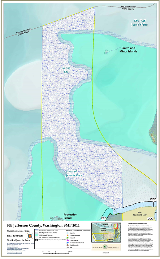
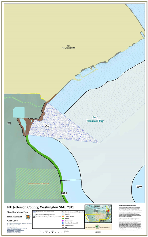
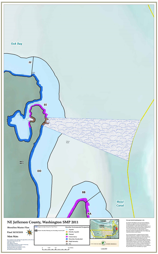
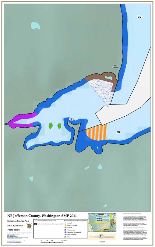
(4) Regulations – General.
(a) When a shoreline permit is issued for a new aquaculture use or development, that permit shall apply to the initial siting, construction, and/or planting or stocking of the facility or farm. If the initial approval is a shoreline substantial development permit, it shall be valid for a period of five years with a possible one-year extension. If the initial approval is a conditional use permit, it shall be valid for the period specified in the permit.
(b) Ongoing maintenance, harvest, replanting, restocking of or changing the species cultivated in any existing or permitted aquaculture operation is not considered new use/development, and shall not require a new permit, unless or until:
(i) The physical extent of the facility or farm is expanded by more than 25 percent or more than 25 percent of the facility/farm changes operational/cultivation methods compared to the conditions that existed as of the effective date of this program or any amendment thereto. If the amount of expansion or change in cultivation method exceeds 25 percent in any 10-year period, the entire operation shall be considered new aquaculture and shall be subject to applicable permit requirements of this section; or
(ii) The facility proposes to cultivate species not previously cultivated in the state of Washington.
(c) Aquaculture uses and activities involving hatching, seeding, planting, cultivating, raising and/or harvesting of planted or naturally occurring shellfish shall not be considered development, as defined in Article II of this chapter, and shall not require a shoreline substantial development permit, unless:
(i) The activity substantially interferes with normal public use of surface waters; or
(ii) The activity involves placement of any structures as defined in Article II of this chapter; or
(iii) The activity involves dredging using mechanical equipment such as clamshell, dipper, or scraper; or
(iv) The activity involves filling of tidelands or bedlands.
(d) The county shall assess the potential for interference described in subsection (3)(c) of this section on a case-by-case basis. All proposed new aquaculture uses or developments shall submit a joint aquatic permit application (JARPA) and SEPA checklist to enable assessment by the county. Activities shall not be considered to substantially interfere with normal public use of surface waters, unless:
(i) They occur in, adjacent to or in the immediate vicinity of public tidelands; and
(ii) They involve the use of floating ropes, markers, barges, floats, or similar apparatus on a regular basis and in a manner that substantially obstructs public access, or passage from public facilities such as parks or boat ramps; or they exclude the public from more than one acre of surface water on an ongoing or permanent basis.
(e) Aquaculture activities not listed in subsection (4)(c) of this section and listed activities that fail to meet any of the criteria in subsection (1)(b) of this section shall require a shoreline substantial development permit (SDP) or conditional use permit (CUP), and shall be subject to all of the following regulations:
(i) Subtidal, intertidal, floating, and upland structures and apparatus associated with aquaculture use shall be located, designed and maintained to avoid adverse effects on ecological functions and processes.
(ii) The county shall consider the location of proposed aquaculture facilities/farms to prevent adverse cumulative effects on ecological functions and processes and adjoining land uses. The county shall determine what constitutes acceptable placement and concentration of commercial aquaculture in consultation with state and federal agencies and tribes based on the specific characteristics of the waterbody, reach, drift cell, and uplands in the vicinity of the farm/facility.
(iii) Upland structures accessory to aquaculture use that do not require a waterside location or have a functional relationship to the water shall be located landward of shoreline buffers required by this program.
(iv) Overwater work shelters and sleeping quarters accessory to aquaculture use/development shall be prohibited.
(v) Floating/hanging aquaculture structures and associated equipment shall not exceed 10 feet in height above the water’s surface. The administrator may approve hoists and similar structures greater than 10 feet in height when there is a clear demonstration of need. The 10-foot height limit shall not apply to vessels.
(vi) Floating/hanging aquaculture facilities and associated equipment, except navigation aids, shall use colors and materials that blend into the surrounding environment in order to minimize visual impacts.
(vii) Aquaculture use and development shall not materially interfere with navigation, or access to adjacent waterfront properties, public recreation areas, or tribal harvest areas. Mitigation shall be provided to offset such impacts where there is high probability that adverse impact would occur. This provision shall not be interpreted to mean that an operator is required to provide access across owned or leased tidelands at low tide for adjacent upland owners.
(viii) Aquaculture uses and developments, except in-water finfish aquaculture, shall be located at least 600 feet from any National Wildlife Refuge, seal and sea lion haulouts, seabird nesting colonies, or other areas identified as critical feeding or migration areas for birds and mammals. In-water finfish facilities, including net pens, shall be located 1,500 feet or more from such areas. The county may approve lesser distances based upon written documentation that U.S. Fish and Wildlife Service (USFWS), Washington Department of Fish and Wildlife (WDFW) and affected tribes support the proposed location.
(ix) Aquaculture use and development shall be sited so that shading and other adverse impacts to existing red/brown macro algae (kelp), and eelgrass beds are avoided.
(x) Aquaculture uses and developments that require attaching structures to the bed or bottomlands shall use anchors, such as helical anchors, that minimize disturbance to substrate.
(xi) Where aquaculture use and development are authorized to use public facilities, such as boat launches or docks, the county shall reserve the right to require the applicant/proponent to pay a portion of the maintenance costs and any required improvements commensurate with the applicant’s/proponent’s use.
(xii) Aquaculture use and development shall employ nonlethal, nonharmful measures to control birds and mammals. Control methods shall comply with existing federal and state regulations.
(xiii) Aquaculture use and development shall avoid use of chemicals, fertilizers and genetically modified organisms except when allowed by state and federal law.
(xiv) Non-navigational directional lighting associated with aquaculture use and development shall be used wherever possible and area lighting shall be avoided and minimized to the extent necessary to conduct safe operations. Non-navigational lighting shall not adversely affect vessel traffic.
(xv) Aquaculture waste materials and by-products shall be disposed of in a manner that will ensure strict compliance with all applicable governmental waste disposal standards, including but not limited to the Federal Clean Water Act, Section 401, and the Washington State Water Pollution Control Act (Chapter 90.48 RCW).
(f) Prior to approving a permit for floating/hanging aquaculture use and development or bottom culture involving structures, the county may require a visual analysis prepared by the applicant/proponent describing effects on nearby uses and aesthetic qualities of the shoreline. The analysis shall demonstrate that adverse impacts on the character of those areas are effectively mitigated.
(5) Regulations – Finfish.
(a) The culture of finfish, including net pens as defined in Article II of this chapter, may be allowed with a discretionary conditional use approval (C(d)) subject to the policies and regulations of this program. All finfish aquaculture (in-water and upland) shall meet, at a minimum, state-approved administrative guidelines for the management of net pen cultures. In the event there is a conflict in requirements, the more restrictive requirement shall prevail.
(b) All in-water finfish aquaculture (in-water and upland) proposals for facilities/operations shall:
(i) Provide the county, at the applicant’s/operator’s expense, a site characterization survey, baseline surveys, and annual monitoring as described in the 1986 Interim Guidelines, or subsequent documents approved by the state. The applicant/operator shall also provide the county with copies of all survey and monitoring reports submitted to Washington Departments of Ecology, Fish and Wildlife, and Natural Resources.
(ii) Submit an operations plan that includes projections for:
(A) Improvements at the site (e.g., pens, booms, etc.) and their relationship to the natural features (e.g., bathymetry, shorelines, etc.);
(B) Number, size and configuration of pens/structures;
(C) Schedule of development and maintenance;
(D) Species cultured;
(E) Fish size at harvest;
(F) Annual production;
(G) Pounds of fish on hand throughout the year;
(H) Average and maximum stocking density;
(I) Source of eggs, juveniles, and broodstock;
(J) Type of feed used;
(K) Feeding method;
(L) Chemical use (e.g., anti-fouling, antibiotics, etc.); and
(M) Predator control measures.
(iii) Provide county with documentation of adequate property damage and personal injury commercial insurance coverage as required by Washington Department of Natural Resources and other agencies.
(iv) Where the county does not have expertise to analyze the merits of a report provided by an applicant, the applicant may be required to pay for third-party peer review of said report.
(c) Bottom Sediments and Benthos.
(i) The depth of water below the bottom of any in-water finfish aquaculture facility shall meet the minimum required by the 1986 Interim Guidelines (i.e., 20 to 60 feet at MLLW), as based on facility production capacity (Class I, II or III) and the mean current velocity at the site, measured as noted in the Guidelines or by more current data/methodology.
(ii) In-water finfish aquaculture operations shall be prohibited where mean current velocity is less than 0.1 knots (five cm/sec).
(iii) The pen configuration (e.g., parallel rows, compact blocks of square enclosures, or clusters of various sized round enclosures, whether oriented in line with or perpendicular to the prevailing current direction) of any in-water finfish aquaculture facility shall be designed and maintained to minimize the depth and lateral extent of solids accumulation.
(iv) The use of unpelletized wet feed shall be prohibited to minimize undigested feed reaching the benthos or attracting scavengers in the water column.
(v) Anchoring or mooring systems shall utilize adequately sized helical devices or other methods to minimize disturbance to the benthos.
(d) Water Quality.
(i) All in-water finfish aquaculture facilities shall be designed, located and operated to avoid adverse impacts to water temperature, dissolved oxygen and nutrient levels, and other water quality parameters. Facilities must comply with National Pollutant Discharge Elimination Standards (NPDES) requirements.
(ii) All in-water finfish aquaculture facilities shall monitor water quality and net cleaning activities to comply with state requirements (including WAC 173-201A-210), especially during periods of naturally high water turbidity. Additional net cleaning activities shall be performed, as needed, to ensure state water quality standards are met.
(e) Phytoplankton.
(i) In-water finfish aquaculture facility production capacity shall be limited in nutrient sensitive areas to protect water quality and shall not exceed 1,000,000 pounds annual production per square nautical mile. The following shall apply for specific geographic areas:
(A) In the main basin of Puget Sound (area south of the sill at Admiralty Inlet extending to the line between Tala Point and Foulweather Bluff, including Port Townsend Bay, Kilisut Harbor, and Oak Bay, and extending to the county’s boundary midway to Whidbey Island), annual production shall be limited by the site characteristics in compliance with this program.
(ii) Applicants shall demonstrate through field and modeling studies that the proposed fish farms will not adversely affect existing biota.
(f) Chemicals.
(i) Only FDA-approved chemicals shall be allowed on a case-by-case basis for anti-fouling, predator control and other purposes. The use of tributyltin (TBT) is prohibited and all chemical use shall be reported to the state as required.
(ii) When necessary, vaccination is preferred over the use of antibiotics. Only FDA-approved antibiotics shall be used and such use shall be reported to the state as required. Operator shall take all necessary precautions to ensure that nearby sediments and shellfish do not accumulate significant amounts of antibiotics.
(g) Food Fish and Shellfish.
(i) All in-water finfish aquaculture facilities shall be located to avoid adverse impacts to habitats of special significance (as defined in Article II of this chapter) and populations of food fish and shellfish as follows, as determined on a case-by-case basis:
(A) When adjacent to any wildlife refuge, sanctuary, aquatic reserve or similar area intended to protect threatened or endangered species, locate a minimum of 300 feet in all directions from such protected areas;
(B) When water depth is less than 75 feet, locate at least 300 feet down-current and 150 feet in all other directions from significant habitats;
(C) When water depth is greater than 75 feet, locate at least 150 feet from significant habitat.
(ii) The county shall designate protective buffer zones around habitats of special significance in accordance with marine area spatial planning efforts led by the state, when such guidance and methodologies are available.
(h) Importation of New Fish Species. All in-water finfish aquaculture facilities shall comply with existing state and federal regulations to ensure importation of new and/or nonnative species does not adversely affect existing and/or native species.
(i) Genetic Issues.
(i) In compliance with state and federal requirements, in-water finfish aquaculture facilities that propose to culture species native to local waters should use stocks with the greatest genetic similarity to local stocks.
(ii) When there is increased risk of interbreeding or establishment of naturalized populations of the cultured species that would be in conflict with native stocks, only sterile or mono-sexual fish shall be allowed.
(iii) All in-water finfish aquaculture facilities shall locate a minimum distance from river mouths where wild fish could be most vulnerable to genetic degradation, as determined on a case-by-case basis or by state guidance.
(j) Escapement and Disease.
(i) All in-water finfish aquaculture facilities shall comply with state and federal requirements to control pests, parasites, diseases, viruses and pathogens and to prevent escapement including, but not limited to, those for certified eggs, approved import/transport and live fish transfer protocols, escapement prevention, reporting and recapture plans, and disease inspection and control per RCW 77.15.290, Chapter 77.115 RCW, Chapters 220-76 and 220-77 WAC and other requirements as appropriate.
(ii) The use of regional broodstock is preferred.
(iii) As consistent with the above mentioned Washington statutes and administrative rules, and other applicable authorities, all in-water finfish aquaculture facility operators shall provide the county with a disease response plan to detail specific actions and timelines to follow when an outbreak is detected. The plan shall address transport permit denial, quarantine, confiscation, removal, and other possible scenarios, identify what agencies will be notified or involved, what alternate facilities may be used, a public information/outreach strategy and other appropriate information.
(k) Marine Mammals and Birds.
(i) All in-water finfish aquaculture facilities shall locate a minimum of 1,500 feet from habitats of special significance for marine mammals and seabirds.
(ii) Only nonlethal techniques (e.g., anti-predator netting) shall be allowed to prevent predation by birds and/or mammals on the cultured stocks.
(l) Visual Quality. All in-water finfish aquaculture facilities shall conduct a visual impact assessment to evaluate and document the following siting and design variables in order to minimize visual impacts to adjacent and surrounding uses:
(i) Locate offshore from low bank shorelines rather than high bluff areas where angle of viewing becomes more perpendicular to the plane of water making the facility more visually evident.
(ii) Locate offshore a minimum of 1,500 feet from ordinary high water mark, or a minimum of 2,000 feet when higher density residential development (rural residential 1:5, urban growth area, master planned resort, and preexisting platted subdivisions with density equivalent/greater to such) is present along the adjacent upland. The county may require a greater distance as determined by a visual impact assessment.
(iii) Facilities shall be designed to maximize a horizontal profile to repeat the plane of the water surface rather than project vertically above the water surface. Vertical height shall be the minimum feasible, not to exceed 10 feet from the surface of the water.
(iv) Facilities shall be designed so that the overall size and surface area coverage does not exceed 10 percent of the normal cone of vision, dependent on the foreshortening created by the offshore distance and the average observation height.
(v) Facilities shall be designed to borrow from the form of structures and materials already in the environment (e.g., pilings, docks, marinas) and to blend with the predominate color schemes present (i.e., blue, green, gray, neutral earth tones). The colors of white and black shall be minimized as they have highly variable appearance in response to lighting conditions. Bright colors such as red, yellow, and orange shall be avoided, unless required for safety purposes. The use of a variety of materials or colors shall be limited and ordered.
(vi) Facilities proposed to locate in the vicinity of existing in-water finfish aquaculture facilities shall evaluate the aggregate impacts and cumulative effects of multiple operations in the same area.
(vii) Facilities shall be designed and located so that the surface area of individual operations does not exceed two acres of surface coverage and no more than one operation per square nautical mile.
(viii) Land based access for parking, staging, launching, and storage associated with any in-water finfish aquaculture facilities shall be evaluated for visual impacts and conflicts with adjacent upland uses.
(m) Navigation, Military Operations and Commercial Fishing.
(i) When appropriate, in-water finfish aquaculture facilities shall be located close to shore and near existing navigational impediments (i.e., marinas, docks).
(ii) All in-water finfish aquaculture facilities shall be designed, located and operated to avoid conflict with military operations.
(iii) The county shall notify, as appropriate, marinas, ports, recreational and commercial boating/fishing organizations, and local tribes about comment opportunities during the permit review process, especially regarding proposed location of fish farm and related navigational aids.
(n) Human Health. All in-water finfish aquaculture facilities shall be designed, located and operated to:
(i) Ensure adequate water quality compatible with good husbandry practices;
(ii) Report any known bacteriological characteristics of fish food used;
(iii) Ensure proper storage of fish food to avoid alteration or degradation of feed quality;
(iv) Regularly monitor and report presence of parasites in farmed fish; and
(v) Comply with federal, state and local food safety requirements including, but not limited to, source identification and country of origin labeling, and hazard analysis and critical control points plan.
(o) Recreation.
(i) All in-water finfish aquaculture facilities shall ensure compliance with state and federal requirements, especially when location is proposed near underwater park facilities.
(ii) All in-water finfish aquaculture facilities shall be located a minimum of 1,000 feet from any recreational shellfish beach, public tidelands, public access facilities (e.g., docks or boat ramps) or other areas of extensive or established recreational use.
(iii) In-water finfish aquaculture operators shall inform the Notice to Mariners and other appropriate entities for nautical chart revisions and notify other sources that inform recreational uses (e.g., boaters, divers, shellfish harvesters).
(p) Noise.
(i) All in-water finfish aquaculture facilities shall be designed, located and operated to:
(A) Ensure compliance with state and federal noise level limits;
(B) Require mufflers and enclosures on all motorized fish farm equipment;
(C) When appropriate, prefer electric motors over internal combustion engines.
(ii) The county may require an acoustical study, conducted at the applicant’s/operator’s expense, to ensure any audible impacts are identified and adequately addressed.
(q) Odor. All in-water finfish aquaculture facilities shall be designed, located and operated to:
(i) Ensure compliance with state limits regarding nuisances and waste disposal;
(ii) Follow best management practices including, but not limited to:
(A) Daily removal and disposal of dead fish and other waste;
(B) Regular cleaning of nets and apparatus;
(C) Storage of food in closed containers;
(D) Walkway design and use allows spilled food to fall into the water.
(iii) Maximize the distance between the facility and nearby residential use/development, downwind location preferred, to minimize impacts resulting from foul odors.
(r) Lighting and Glare.
(i) Facilities shall comply with USCG requirements for operational and navigational lighting. The height of the light source above the water surface shall be the minimum necessary, not to exceed 80 inches, unless otherwise specified by state or federal requirements.
(ii) Facilities shall be designed so that any glare or shadows caused by the solar orientation are minimized.
(iii) Facilities shall utilize materials that minimize glare caused by sunlight or artificial lighting.
(s) Upland Shoreline Use. All in-water finfish aquaculture facilities shall be designed, located and operated to minimize incompatible uses and degradation of upland area.
(t) Local Services.
(i) All in-water finfish aquaculture facilities shall be designed, located and operated to:
(A) Provide estimates of high, average, and low volumes of waste to be produced, including catastrophic events;
(B) Provide a waste management plan to include the method and frequency of collection, storage and disposal; and
(C) Ensure compliance with local, state, federal waste disposal requirements.
(ii) Equipment, structures and materials shall not be discarded in the water and shall not be abandoned in the upland.
(6) Regulations – Application Requirements.
(a) Prior to issuing a permit for any proposed aquaculture use or development, the county may require copies of permit applications and/or studies required by state and federal agencies to ensure provisions of this program are met, including, but not limited to, the following information:
(i) Anticipated harvest cycles and potential plans for future expansion or change in species grown or harvest practices.
(ii) Number, types and dimensions of structures, apparatus or equipment.
(iii) Predator control methods.
(iv) Anticipated levels of noise, light, and odor and plans for minimizing their impacts.
(v) Potential impacts to animals, plants, and water quality due to the discharge of waste water from any upland development.
(vi) Proof of application for an aquatic lands lease from the Washington State Department of Natural Resources (DNR) or proof of lease or ownership if bedlands are privately held.
(vii) Department of Health (DOH) Shellfish Certification Number.
(viii) Department of Fish and Wildlife (DFW) commercial aquatic farm or noncommercial, personal consumption designation.
(ix) Proof of application for any permits required by the U.S. Army Corps of Engineers, Department of Health, or other agency.
(x) Proof of application for any state and federal permits/approvals including any required federal consultation under Section 7 of the Endangered Species Act (16 U.S.C. 1531 et seq., ESA).
(b) Prior to approving a permit for floating/hanging or upland aquaculture use and development or bottom culture involving structures, the county may require a visual analysis prepared by the applicant/proponent describing effects on nearby uses and aesthetic qualities of the shoreline. The analysis shall demonstrate that adverse impacts on the character of those areas are effectively mitigated. [Ord. 7-13 Exh. A (Art. VIII § 2)]
18.25.450 Commercial use.
(1) Policies.
(a) Commercial development should be located, designed and operated to avoid and minimize adverse impacts on shoreline ecological functions and processes.
(b) Water-related commercial uses should not displace existing water-dependent uses, and water-enjoyment commercial uses should not displace existing water-related or existing water-dependent uses, unless there are compelling reasons in the public interest.
(c) Restoration of impaired shoreline ecological functions and processes should be encouraged as part of commercial development.
(d) Commercial development should be visually compatible with adjacent noncommercial properties.
(e) Commercial uses located in the shoreline should provide public access in accordance with JCC 18.25.290 (Public access).
(2) Uses and Activities Prohibited Outright. Commercial parking as a primary use shall be prohibited within the shoreline jurisdiction.
(3) Shoreline Environment Regulations.
(a) Priority Aquatic. Commercial use and development is prohibited, except that small-scale, low intensity water-dependent commercial recreational use and development may be allowed as a conditional use subject to the use and development regulations of the abutting upland shoreline environment designation.
(b) Aquatic. Water-dependent and water-related commercial recreational use and development may be allowed subject to the use and development regulations of the abutting upland shoreline environment designation. Water-enjoyment and non-water-dependent commercial use/development is prohibited.
(c) Natural. Commercial use and development is prohibited, except that small-scale, low intensity water-dependent commercial recreational use and development may be allowed through a conditional use permit.
(d) Conservancy. Water-dependent and water-related commercial use and development may be allowed as a conditional use subject to policies and regulations of this program. Non-water-dependent and non-water-related commercial uses/developments are prohibited, except that small-scale, low intensity recreational/tourist development/use may be allowed with a conditional use permit; provided, that a portion of the use/development is water-dependent or water-related.
(e) Shoreline Residential. Water-oriented commercial use and development may be allowed subject to policies and regulations of this program. Non-water-oriented commercial uses may be allowed as a conditional use.
(f) High Intensity. Water-oriented commercial use and development may be allowed subject to policies and regulations of this program. Non-water-oriented commercial uses may be allowed as a conditional use.
(4) Regulations – Application Requirements.
(a) The county shall require proponents of all commercial use and development to provide the following information at the time of permit application:
(i) Site plans showing the boundaries of the property and any existing structures, indication of existing vegetation and topography, locations of adjacent structures, roads or other infrastructure, and the ordinary high water mark and/or floodway boundary. For comparison, proposed structures and uses shall be overlaid on a site plan of existing conditions; and
(ii) A description of the specific nature and character of the commercial activity (e.g., water-dependent, water-related, water-enjoyment, non-water-oriented, or mixed-use), including a description of the specific components of the proposal; and
(iii) A description of the reason for needing a shoreline location; and
(iv) Any proposed measures to enhance the relationship of the activity to the shoreline; and
(v) A description of the proposed provisions for providing public visual and/or physical access to the shoreline; and
(vi) A description of mitigation measures proposed to ensure that the development will not cause significant adverse environmental impacts.
(b) For mixed-use proposals, at least one alternative design depicting a mixture of uses and activities, structural location, site design, bulk and dimensional configuration, and an alternative approach to public visual and physical access to the shoreline.
(5) Regulations – Water-oriented Use/Development.
(a) Water-oriented commercial use and development shall be allowed when the proponent demonstrates that it will not result in a net loss of shoreline ecological functions or processes, or have significant adverse impact on other shoreline uses, resources and/or values such as navigation, recreation and public access.
(b) A use or development shall not be considered water-dependent, water-related or water-enjoyment until the county determines that the proposed design, layout and operation of the use/development meet the definition and intent of the water-dependent, water-related or water-enjoyment designation.
(c) Where existing water-oriented commercial uses are located in shoreline jurisdiction, any undeveloped and substantially unaltered portion of the waterfront not devoted to water-dependent use shall be maintained for future water-related use.
(6) Regulations – Non-Water-Oriented Use/Development.
(a) Non-water-oriented commercial uses are prohibited on the shoreline unless they meet the following criteria:
(i) The use is part of a mixed-use project that includes water-dependent uses and provides a significant public benefit with respect to the Shoreline Management Act’s objectives such as providing public access and ecological restoration; or
(ii) Navigability is severely limited at the proposed site and the commercial use provides a significant public benefit with respect to the Shoreline Management Act’s objectives such as providing public access and ecological restoration.
(b) When permitted pursuant to subsection (5)(a) of this section, non-water-oriented uses shall provide public access and/or restore shoreline ecological functions as follows:
(i) When part of a mixed-use development, 80 percent of the shoreline buffer area shall be restored to provide shoreline ecological functions and processes that approximate the functions provided by the site in undisturbed or nondegraded conditions.
(ii) When not part of a mixed-use development, the county shall determine the type and extent of public access and restoration on a case-by-case basis according to the opportunities and constraints provided by the site.
(c) The county may waive the requirement to provide public access and/or restoration when:
(i) The site is designated as a public access area by a shoreline public access plan, in which case public access consistent with that plan element shall be provided; or
(ii) The county finds that the size of the parcel and/or the presence of adjacent uses preclude restoration of shoreline ecological functions. In such cases, where on-site restoration is infeasible, equivalent off-site restoration shall be provided consistent with the policies and regulations of this program.
(d) Where restoration is provided pursuant to this section, buffers protecting the restored area shall be sized and designed as appropriate to protect shoreline resources based on a specific restoration plan. The buffer width may differ from the shoreline buffers required in JCC 18.25.270 so as not to encumber adjacent properties, unduly constrain the development site, or create a disincentive for restoration.
(e) Existing non-water-dependent and non-water-related commercial use or development on shorelines that conform to this program may be permitted to expand landward, but not waterward of existing structures, provided the expansion otherwise conforms to this program. [Ord. 7-13 Exh. A (Art. VIII § 3)]
18.25.460 Forest practices.
(1) Policies.
(a) To be consistent with WAC 173-26-241(3)(e), the county should rely on the Forest Practices Act (Chapter 76.09 RCW), its implementing rules, and the 1999 Forest and Fish Report as adequate management of commercial forest uses within shoreline jurisdiction, except for forest conversion activities.
(b) Forest lands should be reserved for long-term forest management and other such uses that are compatible with forest management.
(c) Forest practices should maintain natural surface and ground water movement patterns and protect the quality of surface and ground water.
(d) Forest practices should minimize damage to fish and wildlife species and terrestrial, wetland, and aquatic habitats.
(e) Forest practices should aim to maintain or improve the quality of soils and minimize erosion.
(f) Where slopes are steep or soils are subject to sliding, erosion or high water table, special practices should be employed to minimize damage to shoreland and water bodies, and adjacent properties.
(g) Forest practices should be conducted in a manner that minimizes adverse effects on the aesthetic qualities of shorelines.
(h) Proper road and bridge design, location, and construction and maintenance practices should be used to prevent adversely affecting shoreline resources.
(2) Uses and Activities Prohibited Outright. Forest practices below ordinary high water mark on all shorelines are prohibited.
(3) Shoreline Environment Regulations.
(a) Priority Aquatic. Forest practices are prohibited.
(b) Aquatic. Forest practices are prohibited.
(c) Natural. Forest practices may be allowed with conditional use approval, subject to the policies and regulations of this program.
(d) Conservancy. Forest practices may be allowed subject to the policies and regulations of this program.
(e) Shoreline Residential. Forest practices may be allowed subject to the policies and regulations of this program.
(f) High Intensity. Forest practices may be allowed subject to the policies and regulations of this program.
(4) Regulations.
(a) Timber harvesting and forest practices activities that do not meet the definition of development in Article II of this chapter shall be conducted in accordance with the Washington State Forest Practices Act (Chapter 76.09 RCW), WAC Title 222, and the 1999 Forest and Fish Report, and any regulations adopted pursuant thereto.
(b) Except as provided in subsections (4)(c) and (d) of this section, timber harvesting and forest practices activities that do not meet the definition of development in Article II of this chapter shall not be regulated by this program and shall not require a shoreline permit.
(c) Selective commercial timber cutting on shorelines of statewide significance shall not exceed 30 percent of the merchantable trees in any 10-year period as required by RCW 90.58.150. The county may allow exceptions to the 30 percent limit with a conditional use permit in accordance with WAC 173-26-241(3)(e).
(d) Forest practices roads on slopes that exceed 35 percent shall require a conditional use permit.
(e) Other activities associated with timber harvesting, such as filling, excavation, and building roads and structures, that meet the definition of development shall be regulated according to the general provisions (Article VI of this chapter), shoreline modification provisions (Article VII of this chapter) and/or the other applicable use-specific provisions (this article) of this program and shall require a shoreline substantial development permit or conditional use permit as specified in this program.
(f) Conversion of forest land to nonforestry uses (Class IV Conversion Forest Practices Permit) shall be reviewed in accordance with the provisions for the proposed nonforestry use and the general provisions in Article VI of this chapter and shall be subject to any permit requirements associated with the nonforestry use. [Ord. 7-13 Exh. A (Art. VIII § 4)]
18.25.470 Industrial and port development.
(1) Policies.
(a) In securing shoreline locations for industrial or port development, preference should be given first to water-dependent industrial or port development, then to water-related industrial or port development.
(b) Restoration of impaired shoreline ecological functions and processes should be encouraged as part of industrial and port development.
(c) Industrial and port development should be visually compatible with adjacent noncommercial properties.
(d) Industrial and port uses located in shoreline jurisdiction should provide public access in accordance with JCC 18.25.290 (Public access).
(e) Shorelines suitable for deep-water harbors with access to adequate rail, highway and utility systems should be reserved for water-dependent or water-related industrial and port development.
(f) Port facilities should be designed to allow the public to view harbor areas and should provide public facilities that do not interfere with port operations or endanger public health and safety.
(g) Where feasible, transportation and utility corridors serving industrial and port uses should be located away from the water’s edge to minimize ecological impacts and to reduce the need for waterfront signs and other infrastructure.
(h) Industrial or port development at deep-water sites should be limited to those uses that produce long-term economic benefit and minimize environmental impact.
(i) Industrial and port development should be protected from encroachment or interference by incompatible uses such as residential or commercial uses, which have less stringent siting requirements.
(j) Private and public entities should be encouraged to cooperatively use piers, cargo handling, storage, parking and other accessory facilities in waterfront industrial/port areas.
(k) Log storage is not a desired use of the county’s shoreline and should be allowed only when adequate measures are taken to minimize adverse impacts. Upland log storage is preferred over in-water storage.
(2) Shoreline Environment Regulations.
(a) Priority Aquatic. Industrial/port use and development are prohibited.
(b) Aquatic. Water-dependent and water-related industrial/port use and development may be allowed as a conditional use, subject to the use and development regulations of the abutting upland shoreline environment designation. Uses and developments that are not water-dependent or water-related are prohibited.
(c) Natural. Industrial/port use and development are prohibited.
(d) Conservancy. Only low intensity water-dependent and water-related industrial/port use and development may be allowed as a conditional use, subject to policies and regulations of this program. Uses and developments that are not water-dependent or water-related are prohibited, except that industrial/port use and development that meet the criteria in subsection (5)(a) of this section may be allowed as a conditional use.
(e) Shoreline Residential. Only low intensity water-dependent and water-related industrial/port use and development may be allowed subject to policies and regulations of this program. Uses and developments that are not water-dependent or water-related are prohibited, except that industrial/port use and development that meet the criteria in subsection (5)(a) of this section may be allowed as a conditional use.
(f) High Intensity. Water-dependent and water-related industrial/port use and development may be allowed subject to policies and regulations of this program. Uses and developments that are not water-dependent or water-related may be allowed as a conditional use.
(3) Regulations – General.
(a) Where industrial and port use/development is allowed, it shall be located, designed, and constructed in a manner that minimizes adverse impacts to shoreline resources and shall include mitigation to ensure no net loss of shoreline ecological functions and processes.
(b) Accessory development that does not require a location at or near the water’s edge shall be located upland of the water-dependent portions of the development and outside the shoreline buffer.
(c) Industrial noise caused by volume, frequency, or rhythm shall be muffled or otherwise controlled. Tsunami, air raid and other public safety warning sirens are exempt from this requirement. No vibration shall be permitted that is discernible without instruments on any adjoining non-industrial/port property. The county may require an acoustical study, vibration assessment, and mitigation as needed to address potential noise or vibration impacts.
(d) Industrial and port facilities shall minimize direct or reflected glare and noxious odors discernible without instruments from adjacent properties, streets, or water areas, and must comply with Olympic Region Clean Air Agency (ORCAA) standards.
(e) Docks, piers, pilings and launching facilities accessory to industrial and port development may be permitted; provided, that they serve a water-dependent or water-related use, and comply with JCC 18.25.350 (boating facilities).
(f) Storage or disposal of industrial and port wastes shall be prohibited within shoreline jurisdiction.
(g) Non-water-dependent industrial/port uses may be permitted to occur at facilities previously approved for water-dependent uses under the following conditions:
(i) A specific occupancy plan has been approved that allows interim uses for a specific period while the market for water-dependent uses is being developed and the proposed interim use is consistent with the occupancy plan.
(ii) The period of interim lease or commitment of the space shall not exceed five years. At the end of five years, a new application for interim use shall be submitted.
(iii) The proponent/applicant has made a good faith effort to obtain water-dependent uses. The period of the search for water-dependent uses, the notice of availability, listing or advertising employed, and any inquiries received shall be documented.
(iv) No permanent improvements will be made to the space that require more than five years of occupancy to repay the investment. No permanent improvements will be made that will reduce the suitability of the space for water-dependent use.
(4) Regulations – Water-oriented Use/Development.
(a) Water-oriented industrial/port use and development shall be allowed when the proponent/applicant demonstrates that it will not cause a net loss of shoreline ecological functions or processes or have significant adverse impact on other shoreline uses, resources and/or values such as navigation, recreation and public access.
(b) A use or development shall not be considered water-dependent, water-related or water-enjoyment until the county determines that the proposed design, layout and operation of the use/development meet the definition and intent of the water-dependent, water-related or water-enjoyment designation.
(c) Where existing water-oriented industrial/port uses are located in shoreline jurisdiction, any undeveloped and substantially unaltered portion of the waterfront not devoted to water-dependent use shall be maintained for future water-related use.
(d) Water-dependent industry and port facilities shall be located and designed to minimize the need for initial or recurrent dredging, filling or other harbor and channel maintenance activities.
(5) Regulations – Non-water-oriented Use/Development.
(a) Non-water-oriented industrial/port uses are prohibited in shoreline jurisdiction unless they meet the following criteria:
(i) The site is physically separated from the shoreline by another property or public right-of-way; or
(ii) The use is part of a mixed-use project that includes an associated water-dependent use; or
(iii) Navigability is severely limited at the proposed site; or
(iv) The industrial/port use provides a significant public benefit in the form of public access and/or ecological restoration.
(b) When permitted pursuant to subsection (5)(a) of this section, non-water-oriented uses shall provide public access and/or restore shoreline ecological functions. The county shall determine the type and extent of public access and restoration on a case-by-case basis according to the opportunities and constraints provided by the site.
(c) The county may waive the requirement to provide public access and/or restoration when:
(i) The site is designated as a public access area by a shoreline public access plan, in which case public access consistent with that plan element shall be provided; or
(ii) The county finds that the size of the parcel and/or the presence of adjacent uses preclude restoration of shoreline ecological functions. In such cases, where on-site restoration is infeasible, equivalent off-site restoration shall be provided consistent with the policies and regulations of this program.
(d) Where restoration is provided pursuant to this section, buffers on the restored area shall be designed as appropriate to protect shoreline resources based on a specific restoration plan. The buffer width may differ from the shoreline buffers required in JCC 18.25.270 so as not to encumber adjacent properties or unduly constrain the development site.
(e) Existing non-water-dependent and non-water-related industrial/port development on shorelines that conforms to this program may be permitted to expand landward, but not waterward of existing structures provided the expansion otherwise conforms to this program.
(6) Regulations – Log Storage.
(a) In-water storage or rafting of logs is prohibited unless all of the following conditions are met:
(i) There is no feasible upland location; and
(ii) State water quality standards can be met at all times; and
(iii) The storage does not create an impediment to navigation or interfere with other water-dependent uses; and
(iv) The storage occurs in deep water beyond the photic zone to reduce shading impacts; and
(v) Overland transportation of logs would cause unacceptable transportation impacts; and
(vi) Depths are sufficient to prevent grounding; and
(vii) Easy let-down devices are employed for placing logs in the water. Free-fall or dumping of logs into water shall be prohibited.
(b) Dredging to create log storage facilities shall be prohibited.
(c) Log storage facilities shall be located in existing developed areas to the greatest extent feasible. If a new log storage facility is proposed along an undeveloped shoreline, an alternatives analysis shall be required.
(d) Existing in-water log storage facilities in habitats used by federally listed threatened or endangered species shall be reevaluated if use is discontinued for two years or more or if substantial repair or reconstruction is required.
(e) Offshore log storage shall only be allowed on a temporary basis, and should be located where natural tidal or current flushing and water circulation are adequate to disperse potential contaminants/pollutants.
(f) Appropriate bark and wood debris control, collection and disposal methods shall be employed at log storage areas, log dumps, raft building areas and mill-side handling zones to prevent wood debris from entering the water.
(g) Where water depths will permit the floating of bundled logs, they shall be secured in bundles on land before being placed in the water. Bundles shall not be broken again except on land or at mill-side.
(7) Regulations – Ship Building and Repair Yard Regulations.
(a) Ship and boat building and repair yards shall employ best management practices to control, collect and treat surface runoff to protect the quality of affected waters in accordance with Chapter 90.48 RCW.
(b) Cleaning, surfacing or resurfacing operations occurring over water that may result in the entry of debris into water shall employ fully intact tarps temporarily affixed to the hull above the water line. Prior to removing the tarps, the accumulated contents shall be removed and properly disposed of.
(c) Impervious pavement is required for ship building and repair yards where the wet season water table is less than four feet below surface level.
(8) Regulations – Application Requirements. The county shall require proponents of all industrial use and development to provide the following information at the time of permit application:
(a) Site plans showing the boundaries of the property and any existing structures, indication of existing vegetation and topography, locations of adjacent structures, roads or other infrastructure, and the ordinary high water mark and/or floodway boundary. For comparison, proposed structures and uses shall be overlaid on a site plan of existing conditions; and
(b) A description of the specific nature and character of the industrial activity (e.g., water-dependent or water-related), including a description of the specific components of the proposal; and
(c) A description of the reason for needing a shoreline location; and
(d) Any proposed measures to enhance the relationship of the activity to the shoreline; and
(e) A description of the proposed provisions for providing public visual and physical access to the shoreline; and
(f) A description of potential noise impacts including an acoustical analysis; and
(g) A description of mitigation measures including screening, fencing, and other measures to ensure that the development will not cause significant adverse environmental impacts. [Ord. 7-13 Exh. A (Art. VIII § 5)]
18.25.480 Mining.
(1) Policies.
(a) Mining, as defined in Article II of this chapter, should be located and conducted so as to provide long-term protection of water quality, fish and wildlife species and habitat, to cause the least amount of disruption to the natural shoreline character, resources and ecology, and to avoid net loss of ecological functions in accordance with this program and other applicable laws.
(b) Mining should not be located and conducted where unavoidable adverse impacts to other uses or resources equal or outweigh the benefits from mining.
(c) Mining should not interfere with public access or recreation on the shoreline.
(d) Mining should only be permitted when the proponent provides appropriate studies and detailed operation plans demonstrating all of the following:
(i) Fish habitat, upland habitat and water quality will not be adversely affected;
(ii) The operation will not adversely affect geo-hydraulic processes, channel alignment, nor increase bank erosion or flood damages;
(iii) The operation will provide all feasible measures to protect aquatic resources and anadromous fisheries from pollution related to mining including, but not limited to, sedimentation and siltation; chemical and petrochemical use and spillage, and storage or disposal of wastes and spoils.
(e) Mining operations should be located, designed, and managed so that adjoining properties do not experience adverse impacts from noise, dust or other effects of the operation. The mine operator should be required to implement mitigation measures to minimize adverse proximity impacts.
(f) Mining proposals that result in the creation, restoration, or enhancement of habitat for priority species are preferred over proposals that do not create or improve priority habitat.
(2) Uses and Activities Prohibited Outright. Commercial and industrial extraction and processing of quarry rock, sand, gravel, cobbles or other minerals along any marine or freshwater lake shoreline, or waterward of the ordinary high water mark on any stream/river shoreline, are prohibited.
(3) Shoreline Environment Regulations.
(a) Priority Aquatic. Mining use and development are prohibited.
(b) Aquatic. Mining use and development are prohibited.
(c) Natural. Mining use and development are prohibited, except for transportation of minerals by road.
(d) Conservancy. Mining use and development are prohibited, except for transportation of minerals by road.
(e) Shoreline Residential. Mining use and development are prohibited, except for transportation of minerals by road.
(f) High Intensity. Mining use and development may be allowed as a conditional use (CUP).
(4) Regulations.
(a) All mining activities shall be conducted to ensure compliance with the Washington State Surface Mining Act (Chapter 78.44 RCW), with JCC 18.20.240, 18.30.070, and 18.40.073, and with the no net loss provisions of this program.
(b) As defined in Article II of this chapter, the regulations contained in this section shall apply to all mining operations, including the extraction, primary processing and transport of naturally occurring materials. For the purposes of this section, primary processing shall be construed to include screening, crushing, and stockpiling of materials removed from the site where the processing activity is located. Transport of minerals shall include conveyor systems and barge terminals that are specifically dedicated to transport of mined materials from the site to the marketplace.
(c) No material (such as mining overburden, debris and tailings) or equipment shall be placed in water bodies, critical areas, or floodways and shall be stored so as to prevent erosion or seepage to surface and ground waters.
(d) To minimize noise, dust, vibration, glare and other adverse impacts, a buffer of at least 100 feet wide shall be maintained between any mining site, including accessory facilities, and adjacent properties not used for mining operations. The buffer shall consist of undisturbed soils and native vegetation and shall only include land owned or leased by the mine operator.
(e) The proposed subsequent use of reclaimed mined property shall be consistent with the provisions of the environment designation in which the property is located and that reclamation of disturbed shoreline areas shall provide appropriate ecological processes and functions consistent with the setting. Approved reclamation programs shall be initiated within 60 days following the completion of the mineral extraction operations, in consultation with Washington Department of Natural Resources.
(f) Equipment or apparatus associated with mining operations such as machinery, machine parts, filters, grease and oil containers and rope shall be removed in a timely manner to an appropriate upland location. Proposals for mineral extraction and processing shall be accompanied by a report prepared by a licensed professional geotechnical engineer that includes a description of all of the following:
(i) Types of materials present on the site;
(ii) Quantity and quality of each material;
(iii) Lateral extent and depth of mineral deposits;
(iv) Depth of overburden and proposed depth of mining;
(v) Cross section diagrams indicating present and proposed elevations and/or extraction levels;
(vi) Existing drainage patterns, seasonal or continuous, and proposed alterations to drainage patterns;
(vii) Proposed means of controlling surface runoff and preventing or minimizing erosion and sedimentation;
(viii) The location and sensitivity of any affected flood hazard areas;
(ix) The overall mineral extraction and processing plan, including scheduling, seasonal changes in activity levels, and daily operation schedules;
(x) Proposed screening, buffering or fencing plans consistent with the requirements of this program;
(xi) Anticipated impacts to aquatic and riparian habitat; measures to mitigate or offset adverse impacts; and
(xii) A proposed reclamation plan that, at a minimum, meets the requirements of Chapter 78.44 RCW. [Ord. 7-13 Exh. A (Art. VIII § 6)]
18.25.490 Recreation.
(1) Policies.
(a) Public recreation on public lands is a preferred use of the shoreline. Recreational uses and developments that facilitate the public’s ability to reach, touch, and enjoy the water’s edge, to travel on the waters of the state, and to view the water and the shoreline are preferred. Where appropriate, such facilities should be dispersed along the shoreline in a manner that supports more frequent recreational access and aesthetic enjoyment of the shoreline for a substantial number of people.
(b) Jefferson County should develop a comprehensive shoreline public access plan in collaboration with federal, state, and local organizations whose missions include facilitating public access and recreation opportunities.
(c) Recreational use and development should facilitate appropriate use of shoreline resources while also conserving them.
(d) Linkages between shoreline parks, recreation areas and public access points with linear systems (e.g., water trails, hiking paths, bicycle paths, easements and/or scenic drives) should be provided where feasible.
(e) Recreation facilities should incorporate adequate orientation information and public education regarding shoreline ecological functions and processes, the effect of human actions on the environment and the importance of public involvement in shoreline management. Opportunities to incorporate educational and interpretive information should be pursued in design and operation of recreation facilities and other amenities such as nature trails.
(f) Recreational use and development should be supported by adequate utility and road facilities, or located where such facilities may be provided without significant damage to shore features commensurate with the number and concentration of anticipated users.
(g) The county should encourage the use of street ends and publicly owned lands for shoreline public access to and development of recreational opportunities.
(h) Recreation use and development should be located and designed in a manner that is compatible with the surrounding properties.
(i) Recreational developments are encouraged to use low impact development techniques including but not limited to pervious pavements, to minimize effects associated with stormwater runoff.
(2) Shoreline Environment Regulations.
(a) Priority Aquatic. Water-oriented recreational use and development is allowed subject to the regulations of the abutting upland shoreline environment designation. Underwater parks may be allowed as a conditional use. Non-water-oriented recreation is prohibited.
(b) Aquatic. Water-oriented recreational use and development is allowed subject to the regulations of the abutting upland shoreline environment designation. Underwater parks may be allowed as a conditional use. Non-water-oriented recreation is prohibited.
(c) Natural. Non-water-oriented recreation is prohibited. Low intensity water-oriented recreational use and development may be allowed subject to policies and regulations of this program and the following criteria:
(i) Essential minor structures such as trails, stairs, small picnic areas, primitive roads, viewpoints, restrooms or other appropriate sanitary facilities, interpretive facilities, or development that will not adversely affect shoreline ecological functions and processes are permitted, subject to policies and regulations of this master program.
(ii) Any necessary landscaping shall use native vegetation.
(iii) Recreational development requiring extensive structures or substantial alterations to topography or native vegetation is prohibited.
(d) Conservancy. Non-water-oriented recreation is prohibited. Low intensity water-oriented recreational use and development is allowed subject to policies and regulations of this program and the following criteria:
(i) Structures on sites of one acre or less shall not result in more than five percent building coverage, and total impervious surface shall not exceed 10 percent.
(ii) Structures on sites greater than one acre will not result in more than 10 percent building coverage, and total impervious surface will not exceed 20 percent.
(iii) Alteration of topography shall be limited to the minimum necessary to accommodate allowed use and development.
(iv) Recreational use and development will not result in visitor patterns that degrade shoreline ecological functions.
(e) Shoreline Residential. Water-oriented recreational use and development is allowed subject to the policies and regulations of this master program. Non-water-oriented recreation may be allowed as a conditional use.
(f) High Intensity. Water-oriented recreational use and development is allowed subject to the policies and regulations of this master program. Non-water-oriented recreation is prohibited.
(3) Regulations.
(a) Water-oriented recreational use/development is a preferred use of the shoreline and shall be allowed when the proponent demonstrates that it will not result in a net loss of shoreline ecological functions or processes or have significant adverse impact on other shoreline uses, resources and/or values such as navigation and public access.
(b) Recreation areas or facilities on the shoreline shall provide physical or visual public access consistent with JCC 18.25.290 (Public access).
(c) Underwater parks may be permitted when properly sited and associated with adequate access, restroom facilities and parking. Underwater parks should be located adjacent to existing parks where feasible.
(d) Non-water-oriented recreational facilities with playing fields or with extensive impervious surfaces are not preferred, and if permitted shall incorporate best management practices (BMPs) to prevent erosion, control the amount of runoff and prevent harmful concentrations of chemicals and sediment from entering water bodies.
(e) New recreational use/development shall be located landward of the shoreline buffers required by this program except that components of the recreational use or development that are water-dependent or water-related may be allowed within the shoreline buffer.
(f) Signs indicating the public’s right to access shoreline areas shall be installed and maintained in conspicuous locations at recreational facility points of access and entrances.
(g) When a public recreation site abuts private property/tidelands, signs and other similar markers shall also indicate geographic limits of public access to minimize conflicts with adjacent use/development.
(h) Where appropriate, recreational development proposals shall include provisions for nonmotorized access to the shoreline (e.g., pedestrian, water access and bicycle paths).
(i) Proposals for recreational use and development that involve any clearing, grading or impervious surface shall include a landscape plan that uses species approved by the county. Native, self-sustaining vegetation shall be used as often as possible. The removal of on-site native vegetation shall be limited to the minimum necessary for the development of campsites, selected viewpoints or other permitted structures or facilities and shall be subject to JCC 18.25.310 (Vegetation conservation).
(j) Proposals for recreational development shall include adequate facilities for water supply, sewage and garbage disposal, and recycling commensurate with the intensity of the proposed use. Remotely located sites shall encourage visitors to implement best management practices (BMPs) such as the tread lightly and leave no trace principles of low impact recreation.
(k) Recreational use and development shall incorporate appropriate mitigation to minimize light and noise impacts on adjoining land uses. Such measures shall include, but not be limited to, fencing, screening, and related measures. [Ord. 7-13 Exh. A (Art. VIII § 7)]
18.25.500 Residential.
(1) Policies.
(a) Residential use is not water-dependent but is a preferred use of the shorelines when such development is planned and carried out in a manner that protects shoreline functions and processes to be consistent with the no net loss provisions of this program.
(b) All residential use and development should be planned, designed, located, and operated to avoid adverse impacts on shoreline processes, aquatic habitat, biological functions, water quality and quantity, aesthetics, navigation, and neighboring uses.
(c) All residential use and development should be properly managed to avoid damage to the shoreline environment and prevent cumulative impacts associated with shoreline armoring, overwater structures, stormwater runoff, septic systems, introduction of pollutants, and vegetation clearing.
(d) New residential development should be limited to densities that are consistent with the Jefferson County Comprehensive Plan goals and policies, zoning restrictions, and this program. The density per acre of development should be appropriate to local natural and cultural features.
(e) Low impact development practices and clustering of dwelling units and accessory structures should be implemented as appropriate to preserve natural features, minimize physical impacts and reduce utility and road construction and maintenance costs.
(f) New residential development should be planned and built in a manner that avoids the need for structural shore armoring and flood hazard reduction in accordance with JCC 18.25.380 (Flood control structures) and 18.25.410 (shoreline stabilization) of this program and other applicable plans and laws.
(g) Residential development should be designed to:
(i) Maintain or improve ecological functions and processes; and
(ii) Preserve and enhance native shoreline vegetation; and
(iii) Control erosion; and
(iv) Protect water quality; and
(v) Preserve shoreline aesthetic characteristics; and
(vi) Minimize structural obstructions to public views and normal public use of the shoreline and the water.
(h) Creation of new residential lots through land division should be designed, configured and developed to ensure that no net loss of ecological functions and processes occurs from the plat or subdivision, even when all lots are fully built-out.
(i) Residential developments are encouraged, but not required, to provide public access to the shoreline. New multi-unit residential development, including subdivision of land into more than four parcels, is strongly encouraged to provide public access/open space area equal to at least 30 percent of the total development/subdivision area for use by development residents and the public.
(j) Whenever possible, nonregulatory methods to protect, enhance, and restore shoreline ecological functions should be encouraged for residential development.
(2) Uses and Activities Prohibited Outright.
(a) In-water, overwater or floating residences or accessory dwelling units, including structures located in or on marshes, bogs, swamps, lagoons, tidelands, ecologically sensitive areas or open water areas, are prohibited.
(b) Residential development that can be reasonably expected to require structural shore armoring during the useful life of the structure or within 100 years, whichever is greater, is prohibited.
(c) Residential development within a channel migration zone or floodway that can be reasonably expected to require structural flood protection during the useful life of the structure or within 100 years, whichever is greater, is prohibited.
(d) Land division and boundary line adjustments in shoreline jurisdiction are prohibited when such actions will result in lot configurations that are likely to require:
(i) Significant vegetation removal;
(ii) Structural shore armoring;
(iii) Shoreline modification for erosion control;
(iv) Flood hazard protection; or
(v) Result in a net loss of shoreline ecological functions and processes at the time of development of the subdivision and/or during the useful life of the development or within 100 years, whichever is greater.
(3) Shoreline Environment Regulations.
(a) Priority Aquatic. Residential development is prohibited.
(b) Aquatic. Residential development is prohibited.
(c) Natural. Residential development consisting of one single-family residence per existing legal lot of record may be allowed as a conditional use. Accessory dwelling units shall be prohibited.
(d) Conservancy. Single-family and duplex development may be allowed subject to policies and regulations of this program. All other residential development may be allowed as a conditional use.
(e) Shoreline Residential. Residential development is allowed subject to the policies and regulations of this master program.
(f) High Intensity. Residential development is allowed subject to the policies and regulations of this master program.
(4) Regulations – Primary Residences and Property Subdivision.
(a) Residential use and development shall be planned, designed, located, and operated to avoid adverse impacts on shoreline processes, aquatic habitat, biological functions, water quality, aesthetics, navigation, and neighboring uses.
(b) The buffer requirements in Article VI of this program apply to residences, normal appurtenances, and accessory dwelling units, except that docks, floats, and beach access structures and other water-dependent and water-related structures accessory to residential use may be permitted to encroach into the buffer in accordance with the applicable provisions of this program. Accessory structures must be sited and designed to not require shoreline armoring within 100 years.
(c) Cluster development and appropriate low impact development practices shall be required for development sites constrained by critical areas and/or shoreline buffers.
(d) When zoning regulations allow, proposals for multi-story residential development greater than 35 feet above average grade must include an analysis of how the structure would impact the views of surrounding residents. If the proposed residence would block or significantly compromise the view of a substantial number of residences on adjoining areas, the county shall limit the height to 35 feet, or require design revisions or relocation to prevent the loss of views to neighboring properties.
(e) New multi-unit residential development, including subdivision of land into more than four parcels, shall provide public access/open space for use by development residents and the public. The county may alter the recommended area threshold per constitutional limits or waive this requirement if public access is infeasible due to incompatible uses, safety, impacts to shoreline ecology or legal limitations. The county may require alternatives to on-site physical access if on-site physical access is infeasible for the reasons noted.
(f) As per Article VI of this chapter, new or expanded subdivisions and planned unit developments comprised of four or more lots or units shall provide public access to publicly owned shorelines or public water bodies unless:
(i) The site is designated in a shoreline public access plan for a greater component of public access; or
(ii) The public access is demonstrated to be infeasible or inappropriate.
(g) New or amended subdivisions, except those for lot line adjustment and lot consolidation purposes, shall provide public access as required in Article VI of this chapter.
(h) When required for multi-lot/multi-unit residential development, the amount of public access/open space area shall be determined by site analysis per constitutional limits. The county may waive this requirement if public access is infeasible due to incompatible uses, risks to health or safety, impacts to shoreline ecology or legal limitations. In such cases, the county may require alternatives to on-site physical access if on-site physical access is infeasible for the reasons noted.
(i) The type and configuration of public access required for multi-unit/multi-lot residential development shall depend on the proposed use(s) and the following criteria:
(i) Subdivisions within shoreline jurisdiction that have views of water areas shall at a minimum provide an area from which the public can view the shoreline.
(ii) Subdivisions adjacent to public waterways or tidelands shall provide physical access to public waters/tidelands that are accessible at low tide or low water.
(5) Regulations – Accessory Structures/Uses.
(a) Accessory dwelling units may be permitted when the primary residential use is allowed pursuant to, and only when, other provisions of this program are met.
(b) Accessory structures and uses such as boating facilities, pedestrian beach access structures, shore armoring and shore stabilization shall be subject to the applicable provisions of Article VII of this chapter.
(c) A single water-dependent boathouse, as defined in Article II of this chapter, accessory to single-family residential development may be allowed with a conditional use permit and in accordance with JCC 18.25.270(5)(d)(iii) and other provisions of this program.
(d) A shoreline substantial development permit or conditional use permit shall be required for all accessory development that is not considered a normal appurtenance. [Ord. 7-13 Exh. A (Art. VIII § 8)]
18.25.510 Signs.
(1) Policies.
(a) Signs should be located, designed and maintained to be visually compatible with local shoreline scenery as seen from both land and water, especially on shorelines of statewide significance.
(b) Sign location and design should not significantly impair shoreline views.
(c) To avoid continued proliferation of single purpose signs, communities, districts, and/or multi-use or multi-tenant commercial developments are encouraged to erect single, common use gateway signs to identify and give directions to local premises and public facilities.
(d) Signs of a commercial or industrial nature should be limited to those areas or premises to which the sign messages refer.
(e) Off-premises signs (including billboards) should not be located on shorelines except for approved community gateway or directional signs.
(f) Signs near scenic vistas and viewpoints should be restricted in number, location, and height so that enjoyment of these areas is not impaired.
(g) Freestanding signs should be located to avoid blocking scenic views and be located on the landward side of public transportation routes which generally parallel the shoreline.
(h) To minimize negative visual impacts and obstructions to shoreline access and use, low profile, on-premises wall signs are strongly preferred over freestanding signs or off-premises wall signs.
(i) Signs should be designed mainly to identify the premises and nature of enterprise without unduly distracting uninterested passersby.
(2) Shoreline Environment Regulations.
(a) Priority Aquatic. Only wall signs and low profile freestanding signs under 30 inches in height for water-dependent uses may be allowed subject to the use and development regulations of the abutting upland shoreline environment designation. No one premises may maintain more than two signs in a priority aquatic shoreline area.
(b) Aquatic. Only wall signs and low profile freestanding signs under 30 inches in height for water-dependent uses may be allowed subject to the use and development regulations of the abutting upland shoreline environment designation. No one premises may maintain more than two signs in an aquatic shoreline area.
(c) Natural. Sign development is prohibited, except for trail marking, hazard warnings, or interpretive scientific or educational purposes and personal signs. Such allowed signs shall be limited in size and number to those required to effect their purpose.
(d) Conservancy. Signs may be permitted subject to the policies and regulations of this master program.
(e) Shoreline Residential. Signs may be allowed subject to the policies and regulations of this master program.
(f) High Intensity. Signs may be allowed subject to the policies and regulations of this master program.
(3) Regulations.
(a) Signs shall comply with JCC 18.30.150 and exemptions listed there also apply in this program.
(b) Plans and designs for non-exempt signs must be submitted for review at the time of shoreline permit application.
(c) All signs shall be located and designed to minimize interference with vistas, viewpoints, and visual access to the shoreline.
(d) Overwater signs or signs on floats or pilings shall be prohibited, except when related to navigation or a water-dependent use.
(e) Illuminated signs shall be hooded, shaded, or directed so as to eliminate glare when viewed from surrounding properties or watercourses.
(f) No signs shall be placed in view corridors required as a condition of permit approval under this master program.
(g) The following types of signs may be permitted, subject to the provisions contained within this section:
(i) Water navigational signs and highway and railroad signs necessary for operation, safety and direction;
(ii) Public information/interpretive signs directly relating to a shoreline resource, use or activity;
(iii) Off-premises, free signs for community identification, information, or directional purposes;
(iv) Signs with changing messages; provided, that the information displayed is limited to time, temperature or date or public noncommercial messages;
(v) National, state or institutional flags or temporary decorations customary for special holidays and similar events of a public nature; and
(vi) Temporary directional signs to public or quasi-public events if removed within 10 days following the event.
(h) The following types of signs are prohibited:
(i) Signs that impair visual access through view corridors;
(ii) Off-premises, detached outdoor advertising signs;
(iii) Signs that incorporate spinners, streamers, pennants, flashing or blinking lights and moving devices, except for public highway and railroad signs;
(iv) Signs placed on trees or other natural features; and
(v) Commercial signs for products, services or facilities located off site. [Ord. 7-13 Exh. A (Art. VIII § 9)]
18.25.520 Transportation.
(1) Policies.
(a) Major new roads, railroads and parking areas should be located outside of the shoreline jurisdiction whenever feasible.
(b) Maintenance and repair of existing roads in shoreline jurisdiction shall use all reasonable methods to minimize adverse impacts on nearby shorelines.
(c) Road and railroad locations should be planned to fit the topographical characteristics of the shoreline to minimize alterations to natural shoreline conditions.
(d) New transportation facilities should be designed and located to minimize the need for the following:
(i) Structural shoreline protection measures;
(ii) Modifications to natural drainage systems; and
(iii) Waterway crossings.
(e) Planning for transportation and circulation corridors shall consider location of public access facilities, and be designed to promote safe and convenient access to those facilities.
(f) Pedestrian trails and bicycle paths along shorelines are encouraged where they are compatible with the natural character, resources, and ecology of the shoreline.
(g) When transportation corridors are necessary within shoreline jurisdiction, joint-use corridors are preferred and encouraged for roads, utilities, and motorized forms of transportation/circulation.
(h) Parking in shoreline areas should be limited to that which directly serves a permitted shoreline use.
(i) Parking facilities should be located and designed to minimize adverse environmental impacts to the following, including, but not limited to:
(i) Stormwater runoff;
(ii) Water quality;
(iii) Visual qualities;
(iv) Public access; and
(v) Vegetation and habitat.
(j) Parking areas should be planned to achieve optimum use. Where feasible, parking areas should serve more than one use (e.g., recreational use on weekends, commercial use on weekdays).
(k) Transportation facilities should employ pervious materials and other appropriate low impact development techniques where soils and geologic conditions are suitable and where such measures could measurably reduce stormwater runoff.
(2) Uses and Activities Prohibited Outright.
(a) Parking as a primary use shall be prohibited within shoreline jurisdiction.
(b) Parking is prohibited on structures located in or over water.
(3) Shoreline Environment Regulations.
(a) Priority Aquatic. Transportation facilities that provide access to water-dependent or water-related uses may be allowed as a conditional use subject to the use and development regulations of the abutting upland shoreline environment designation. New or expanded stream crossings serving non-water-dependent or non-water-related uses may be allowed as a conditional use subject to the use and development regulations of the abutting upland shoreline environment designation.
(b) Aquatic. Transportation facilities that provide access to water-dependent or water-related uses may be allowed as a conditional use subject to the use and development regulations of the abutting upland shoreline environment designation. New or expanded stream crossings for non-water-dependent or non-water-related uses may be allowed as a conditional use subject to the use and development regulations of the abutting upland shoreline environment designation.
(c) Natural. Transportation facilities are prohibited, except to access approved public recreational development.
(d) Conservancy. Transportation facilities may be allowed subject to policies and regulations of this program. Transportation facilities not serving a specific approved use, including roads, railways, and parking areas, may be allowed as a conditional use, provided there is no feasible location outside of the shoreline.
(e) Shoreline Residential. Transportation facilities may be allowed subject to policies and regulations of this program. Transportation facilities not serving a specific approved use, including roads, railways, and parking areas, may be allowed as a conditional use, provided there is no feasible location outside of the shoreline.
(f) High Intensity. Transportation facilities may be allowed subject to policies and regulations of this program. Transportation facilities not serving a specific approved use, including roads, railways, and parking areas, may be allowed as a conditional use, provided there is no feasible location outside of the shoreline.
(4) Regulations – Design and Operation.
(a) New transportation facilities in shoreline jurisdiction shall be located to be as far away from shoreline features as possible and shall be designed to generally follow natural topography, to minimize cuts and/or fills, and to avoid adverse impacts to shoreline ecological functions and processes, including channel migration zones (CMZs). Wherever roads or railway embankments cross waterways including remnant stream channels and oxbow bends, crossings of ample cross-section shall be provided to span the feature.
(b) Raised arterial roads or railways shall be built outside the floodway except for necessary crossings. If built in the floodplain, such routes shall be designed to avoid obstructing floodwaters. Any parking areas required along such roads shall be located to prevent or minimize the need for flood control or shoreline armoring. Local access roads in floodplains shall be built so that floodwaters are not obstructed nor diverted.
(c) Transportation facilities shall be designed so that no significant loss of floodway capacity nor measurable increase in predictable flood levels will result. Such facilities shall avoid placing structures within the channel migration zone or any dynamic, shifting channel area.
(d) In instances where water crossing is required, roads shall cross shoreline areas and water bodies by the shortest, most direct route feasible unless such route would cause more damage to the environment.
(e) When an in-water or overwater development or structure is required for construction, operation or maintenance of transportation facilities, it shall meet all provisions of this section and this program.
(f) Bridge supports and abutments shall be designed and spaced so they do not act as walls baffling or blocking flood waters, or interrupting stream channel processes or littoral drift.
(g) Bridges and culverts shall be used in accordance with WDFW guidance to protect shoreline ecological functions and processes. Transportation crossings over ordinary high water in floodways shall be constructed on open piling, support piers, culverts, or other similar measures to preserve hydraulic processes.
(h) Parking facilities shall only be permitted in shoreline jurisdiction to support an authorized use where it can be demonstrated that there are no feasible alternative locations away from the shoreline.
(i) Transportation facilities shall be constructed of materials that will not adversely affect water quality or aquatic plants and animals over the long term. Elements within or over water shall be constructed of materials approved by applicable state agencies for use in water for both submerged portions and other components to avoid discharge of pollutants from splash, rain or runoff. Wood or pilings treated with creosote, pentachlorophenol or other similarly toxic materials are prohibited. Preferred materials are concrete and steel.
(j) Transportation development shall be carried out in a manner that maintains or improves state water quality standards for affected waters.
(k) Pervious materials and low impact development techniques shall be used to manage stormwater runoff where feasible and where conditions are appropriate.
(l) Non-emergency construction and repair work shall be scheduled for that time of year when seasonal conditions (weather, streamflow) permit optimum feasible protection of shoreline ecological functions and processes.
(m) Transportation shall be required to make joint use of rights-of-way and to consolidate crossings of water bodies where adverse impact to the shoreline can be minimized by doing so.
(n) Roads and railroads shall be located to minimize the need for routing surface waters into and through culverts.
(5) Regulations – Parking.
(a) Parking shall only be permitted in shoreline jurisdiction when necessary to support an authorized use where it can be demonstrated that there are no feasible alternative locations away from the shoreline. Parking facilities shall be buffered from the water’s edge and less intense adjacent land uses by vegetation, undeveloped space, or structures developed for the authorized primary use to the maximum practicable extent.
(b) Parking areas shall be developed using low impact development techniques whenever possible including but not limited to the use of permeable surfacing materials.
(c) Parking facilities shall be designed and located to minimize adverse impacts upon abutting properties. Landscaping shall consist of county-approved vegetation species planted prior to completion of the parking area. Landscape plantings shall be selected, planted and maintained to provide effective screening within three years of project completion and through maturity of the species.
(d) Parking facilities serving individual buildings shall be located landward of the principal building being served, except when the parking facility is located within or beneath the structure and is adequately screened, or in cases when an alternate location would have less environmental impact on the shoreline.
(e) Parking facilities for shoreline uses shall be designed to provide safe and convenient pedestrian circulation within the parking area and to the shorelines.
(f) Parking facilities shall be provided with facilities adequate to prevent surface water runoff from contaminating water bodies, using best available technologies. A parking facility maintenance program shall be required to assure the proper functioning of drainage facilities over time. [Ord. 7-13 Exh. A (Art. VIII § 10)]
18.25.530 Utilities.
(1) Policies.
(a) New public or private utilities should be located inland from the land/water interface, preferably outside of the shoreline, unless:
(i) The utility requires a location adjacent to the water; or
(ii) Alternative locations are infeasible; or
(iii) Utilities are required for permitted shoreline uses consistent with this program.
(b) Utilities should be located and designed to avoid public recreation and public access areas and significant historic, archaeological, cultural, scientific or educational resources.
(c) Pipeline and cable development should be designed and sited to avoid crossing aquatic lands. If a water crossing is unavoidable, it should be located in an area that will cause the least adverse ecological impact, be installed using the methods that minimize adverse impacts, and be the shortest length feasible.
(d) Utility facilities of all kinds that would require periodic maintenance activities should avoid shoreline locations to prevent disruption of shoreline ecological functions.
(e) New utilities should use existing transportation and utility sites, rights-of-way and corridors, rather than creating new corridors.
(f) New utility installations should be planned, designed and located to eliminate the need for structural shoreline armoring or flood hazard reduction measures.
(g) Utility facilities and corridors should be planned, designed and located to protect scenic views. Where feasible, conveyance utilities should be placed underground or alongside or under bridges, unless doing so would cause greater ecological impact or harm.
(h) Power generating facilities and other utilities using emerging technologies such as tidal energy generators should be carefully evaluated to ensure that the potential impacts are fully understood. Before approving such facilities, the county should consider whether the benefits to the public outweigh the potential impacts. The county should ensure such facilities are designed and located to protect ecological functions and shoreline resources.
(2) Shoreline Environment Regulations.
(a) Priority Aquatic.
(i) Submarine electrical and communications cables, water lines, sewer lines, fuel pipelines, sewer outfalls, overwater public utility lines consisting of local distribution lines, water intakes, and desalinization facility intakes/outfalls may be allowed as conditional uses subject to policies and regulations of this program and subject to the use and development regulations of the abutting upland shoreline environment designation.
(ii) All other utility development is prohibited.
(b) Aquatic.
(i) Submarine electrical and communications cables, water lines, sewer lines, fuel pipelines, sewer outfalls, overwater public utility lines consisting of local distribution lines, water intakes, and desalinization facility intakes/outfalls may be allowed as conditional uses subject to policies and regulations of this program and subject to the use and development regulations of the abutting upland shoreline environment designation.
(ii) Submarine water and sewer lines, fuel pipelines, and sewer outfalls may be allowed as conditional uses subject to the use and development regulations of the abutting upland shoreline environment designation.
(iii) Tidal generating facilities may be allowed as a conditional use.
(iv) All other utility development is prohibited.
(c) Natural.
(i) Utility development is prohibited.
(ii) Maintenance of existing utilities is allowed; provided, that the operator makes every effort to protect shoreline ecological functions and the natural features therein. Removal of existing utilities is preferred over time.
(iii) Utilities accessory to and serving permitted uses are allowed.
(d) Conservancy. Utility development consisting of local distribution facilities is allowed subject to policies and regulations of this program. The following may be allowed as a conditional use, provided there is no feasible location outside shoreline jurisdiction: sewage outfalls and treatment plants, overwater communication or power lines, fuel pipelines, and other types of hazardous material pipelines, regional facilities, including transmission facilities serving customers outside of Jefferson County, desalinization facilities, and power generating facilities. Freestanding communication towers are prohibited.
(e) Shoreline Residential. Utility development consisting of local distribution facilities is allowed subject to policies and regulations of this program. The following may be allowed as a conditional use, provided there is no feasible location outside shoreline jurisdiction: regional facilities, including transmission facilities serving customers outside of Jefferson County, desalinization facilities, and power generating facilities.
(f) High Intensity. Utility development consisting of local distribution facilities is allowed subject to policies and regulations of this program. The following may be allowed as a conditional use, provided there is no feasible location outside shoreline jurisdiction: regional facilities, including transmission facilities serving customers outside of Jefferson County, desalinization facilities, and power generating facilities.
(3) Regulations – General.
(a) All underwater pipelines transporting liquids intrinsically harmful to aquatic life or potentially injurious to water quality are prohibited, except in situations where no other feasible alternative exists. In those limited instances when permitted, automatic shut-off valves shall be provided on both sides of the water body, and pipe sleeves shall be used to facilitate repair without future encroachment on surface waters and wetlands, unless more feasible or technically superior alternatives exist that provide equivalent protection, as deemed by the administrator.
(b) Utilities that are not water-dependent shall be located outside shoreline buffers unless it is demonstrated that alternative locations and alternative technology are infeasible.
(c) The construction, operation and maintenance of utilities shall not cause a net loss of shoreline ecological functions or processes or adversely impact other shoreline resources and values.
(d) The following information shall be required for all proposals for utility facilities:
(i) A description of the proposed facilities; and
(ii) The rationale and justification for siting the proposed facility within shoreline jurisdiction; and
(iii) A discussion of alternative locations considered and reasons for their elimination; and
(iv) A description of the location of other utility facilities in the vicinity of the proposed project and any plans to include facilities or other types of utilities in the project; and
(v) A plan for the reclamation of areas disturbed both during construction and following decommissioning and/or completion of the useful life of the facility; and
(vi) A plan for the control of erosion and turbidity during construction and operation; and
(vii) An analysis of alternative technologies; and
(viii) Documentation that utilities avoid public recreation areas and significant natural, historic or archaeological or cultural sites or that no alternative is feasible and that all feasible measures to reduce harm have been incorporated into the proposal.
(ix) When feasible, utility lines shall use existing rights-of-way, corridors and/or bridge crossings and shall avoid duplication and construction of new or parallel corridors in all shoreline areas.
(e) Utility facilities shall be constructed using techniques that minimize the need for shoreline fill. When crossing water bodies, pipelines and other utility facilities shall use pier or open pile construction.
(f) Vegetation clearing during utility installation or maintenance shall be minimized, and disturbed areas shall be restored or enhanced following project completion consistent with the requirements of this program.
(4) Regulations – Water Systems.
(a) Components of water systems that are not water-dependent shall be located away from the shoreline. Private and public intake facilities should be located where there will be no net loss in ecological functions or adverse impacts upon shoreline resources, values, natural features, or other users.
(b) Desalinization facilities shall be located outside of critical areas and landward of shoreline buffers, except for water-dependent components such as water intakes.
(5) Regulations – Essential Public Facilities.
(a) Essential public facilities shall be located, developed, managed, and maintained in a manner that protects shoreline ecological functions and processes.
(b) Essential public facilities shall be designed to enhance shoreline public access and aesthetics.
(c) Essential public facilities shall be located outside of shoreline jurisdiction unless they require a waterfront location or unless there is no feasible alternative.
(6) Regulations – Sewage Systems.
(a) Outfall pipelines and diffusers are water-dependent but shall be located to minimize adverse effects on shoreline ecological functions and processes or adverse impacts upon shoreline resources and values.
(b) Septic tanks and drain fields are prohibited where public sewer is readily available.
(7) Regulations – Solid Waste Facilities.
(a) Facilities for processing and storage and disposal of solid waste are not normally water-dependent. Components that are not water-dependent shall not be permitted on shorelines.
(b) Disposal of solid waste on shorelines or in water bodies has potential for severe adverse effects upon ecological processes and functions, property values, public health, natural resources, and local aesthetic values, and shall not be permitted.
(c) Temporary storage of solid waste in suitable receptacles is permitted as accessory to a permitted primary use or for litter control.
(8) Regulations – Oil, Gas and Natural Gas Transmission.
(a) Oil, gas and natural gas transmission and distribution pipelines and related facilities shall not be located in shoreline areas unless alternatives are demonstrated to be infeasible.
(b) Local natural gas service lines shall not be located in shoreline areas unless serving approved shoreline uses. Crossings of shorelines shall not be approved unless alternatives are demonstrated to be infeasible.
(c) Developers and operators of pipelines and related facilities for gas and oil shall be required to demonstrate adequate provisions for preventing spills or leaks, as well as established procedures for mitigating damages from spills or other malfunctions and shall demonstrate that periodic maintenance will not disrupt shoreline ecological functions.
(9) Regulations – Electrical Energy and Communication Systems.
(a) Systems components (including substations, towers, and transmission and distribution lines) that are not water-dependent shall not be located on shorelines unless alternatives are infeasible.
(b) Underground placement of lines shall be required for new or replacement lines that are parallel to the shoreline, and do not cross water bodies. New or replacement lines that cross water or critical areas may be required to be placed underground depending on impacts on ecological functions and processes and visual impacts. Poles or supports treated with creosote or other wood preservatives that may be mobile in water shall not be used along shorelines or associated wetlands.
(10) Regulations – Power Generation Facilities. Power generation facilities involving emerging technologies such as tidal energy shall not be permitted until and unless the county determines that the adverse effects can be fully mitigated and the public benefits clearly outweigh the risks to the shoreline environment. [Ord. 7-13 Exh. A (Art. VIII § 11)]
Article IX. Permit Criteria and Exemptions
18.25.540 Substantial development permit criteria.
To be authorized, all uses and developments shall be planned and carried out in a manner that is consistent with this program and the policy of the Act as required by RCW 90.58.140(1), regardless of whether a shoreline permit, statement of exemption, shoreline variance, or shoreline conditional use permit is required. [Ord. 7-13 Exh. A (Art. IX § 1)]
18.25.550 Exemptions from shoreline substantial development permit process.
(1) Exemptions shall be construed narrowly. Only those developments that meet the precise terms of one or more of the listed exemptions may be granted exemptions from the substantial development permit process.
(2) An exemption from the substantial development permit process is not an exemption from compliance with the Act or this program, or from any other regulatory requirements. To be authorized, all uses and developments must be consistent with the policies and provisions of this program and the Act.
(3) A use or development or use that is listed as a conditional use pursuant to this program or is an unlisted use or development, must obtain a conditional use permit even if the development or use does not require a substantial development permit.
(4) When a development or use is proposed that does not comply with the bulk, dimensional and/or performance standards of this program, such development or use shall only be authorized by approval of a shoreline variance even if the development or use does not require a substantial development permit.
(5) The burden of proof that a development or use is exempt is on the applicant/proponent of the exempt development action.
(6) If any part of a proposed development is not eligible for exemption, then a substantial development permit is required for the entire proposed development project.
(7) All permits or statements of exemption issued for development or use within shoreline jurisdiction shall include written findings prepared by the administrator, including compliance with bulk and dimensional standards and policies and regulations of this program. The administrator may attach conditions to the approval of exempt developments and/or uses as necessary to assure consistency of the project with the Act and this program. [Ord. 7-13 Exh. A (Art. IX § 2)]
18.25.560 Exemptions listed.
The following activities shall be considered exempt from the requirement to obtain a shoreline substantial development permit in accordance with RCW 90.58.030 and WAC 173-27-040:
(1) Fair Market Value. Any development of which the total cost or fair market value, whichever is higher, does not exceed $6,416 or as adjusted by WAC 173-27-040, if such development does not materially interfere with the normal public use of the water or shorelines of the state. For the purpose of determining whether or not a permit is required, the total cost or fair market value shall be based on the value of development that is occurring on shorelines of the state as defined in RCW 90.58.030(2)(c). The total cost or fair market value of the development shall include the fair market value of any donated, contributed or found labor, equipment or materials.
(2) Maintenance and Repair. Normal maintenance or repair of existing structures or developments, including damage by accident, fire or elements. Normal maintenance includes those usual acts to prevent a decline, lapse or cessation from a lawfully established condition. Normal repair means to restore a development to a state comparable to its original condition within a reasonable period after decay or partial destruction except where repair causes substantial adverse effects to the shoreline resource or environment. Replacement of a structure or development may be authorized as repair where such replacement is the common method of repair for the type of structure or development and the replacement structure or development is comparable to the original structure or development including but not limited to its size, shape, configuration, location and external appearance and the replacement does not cause substantial adverse effects to shoreline resources or the environment.
(3) Residential Bulkhead. Construction of the normal protective bulkhead common to single-family residences. A normal protective bulkhead includes those structural and nonstructural developments installed at or near, and parallel to, the ordinary high water mark for the sole purpose of protecting an existing single-family residence and appurtenant structures from loss or damage by erosion. A normal protective bulkhead is not exempt if constructed for the purpose of creating dry land. When a vertical or near vertical wall is being constructed or reconstructed, not more than one cubic yard of fill per one foot of wall may be used for backfill. When an existing bulkhead is being repaired by construction of a vertical wall fronting the existing wall, it shall be constructed no further waterward of the existing bulkhead than is necessary for construction of new footings. When a bulkhead has deteriorated such that an ordinary high water mark has been established by the presence and action of water landward of the bulkhead, then the replacement bulkhead must be located at or near the actual ordinary high water mark. Beach nourishment and bioengineering erosion control projects may be considered a normal protective bulkhead when any structural elements are consistent with the above requirements and when the project has been approved by the Washington Department of Fish and Wildlife.
(4) Emergency Construction. Emergency construction necessary to protect property from damage by the elements. An emergency is an unanticipated and imminent threat to public health, safety or the environment that requires immediate action within a time too short to allow full compliance with this program. Emergency construction does not include development of new permanent protective structures where none previously existed. Where new protective structures are deemed by the administrator to be the appropriate means to address the emergency situation, upon abatement of the emergency situation the new structure shall be removed or any permit that would have been required, absent an emergency, pursuant to Chapter 90.58 RCW, Chapter 173-27 WAC or this program, shall be obtained. All emergency construction shall be consistent with the policies of Chapter 90.58 RCW and this program. As a general matter, flooding or other seasonal events that can be anticipated and may occur but that are not imminent are not an emergency.
(5) Agriculture. Construction and practices normal or necessary for farming, irrigation, and ranching activities, including agricultural service roads and utilities, construction of a barn or similar agricultural structure, and the construction and maintenance of irrigation structures including, but not limited to, head gates, pumping facilities, and irrigation channels. A feedlot of any size, all processing plants, other activities of a commercial nature, or alteration of the contour of the shorelands by leveling or filling other than that which results from normal cultivation, shall not be considered normal or necessary farming or ranching activities. A feedlot shall be an enclosure or facility used or capable of being used for feeding livestock hay, grain, silage, or other livestock feed, but shall not include land for growing crops or vegetation for livestock feeding and/or grazing, nor shall it include normal livestock wintering operations.
(6) Drainage. Operation and maintenance of any system of dikes, ditches, drains, or other facilities existing on June 4, 1975, that were created, developed or utilized, primarily as a part of an agricultural drainage or diking system.
(7) Navigation Aids. Construction or modification, by or under the authority of the Coast Guard or a designated port management authority, of navigational aids such as channel markers and anchor buoys.
(8) Single-Family Residences. Construction on shorelands by an owner, lessee, or contract purchaser of a single-family residence for their own use or for the use of their family, which residence does not exceed a height of 35 feet above average grade level and that meets all requirements of the state agency or local government having jurisdiction thereof. Single-family residence means a detached dwelling designed for and occupied by one family including those structures and developments within a contiguous ownership which are a normal appurtenance as defined in Article II of this chapter.
(9) Residential Docks. Construction of an individual/single-user or shared dock for private noncommercial pleasure craft, for use by the owner, lessee, or contract purchaser of a single-family or multifamily residence. The private dock exemption applies to dock construction cost as specified in RCW 90.58.030(3)(e).
(10) Irrigation. Operation, maintenance, or construction of canals, waterways, drains, reservoirs, or other facilities that now exist or are hereafter created or developed as a part of an irrigation system for the primary purpose of making use of system waters including return flow and artificially stored ground water for the irrigation of lands; provided, that this exemption shall not apply to construction of new irrigation facilities proposed after December 17, 2003.
(11) State Property. The marking of property lines or corners on state owned lands, when such marking does not significantly interfere with normal public use of the surface of the water.
(12) Energy Facilities. Any project with a certification from the governor pursuant to Chapter 80.50 RCW.
(13) Site Exploration. Site exploration and investigation activities that are prerequisite to preparation of a development application for authorization under this program, if:
(a) The activity does not interfere with the normal public use of surface waters;
(b) The activity will have no significant adverse impact on the environment including but not limited to fish, wildlife, fish or wildlife habitat, water quality and aesthetic values;
(c) The activity does not involve the installation of any structure and, upon completion of the activity, the vegetation and land configuration of the site are restored to conditions existing before the activity;
(d) A private entity seeking development authorization under this section first posts a performance bond or provides other evidence of financial responsibility to the administrator to ensure that the site is restored to preexisting conditions; and
(e) The activity is not subject to the permit requirements of RCW 90.58.550.
(14) Noxious Weeds. The process of removing or controlling aquatic noxious weeds, as defined in RCW 17.26.020, through the use of an herbicide or other treatment methods applicable to weed control that are recommended by a final environmental impact statement published by the Department of Agriculture or the Department of Ecology jointly with other state agencies under Chapter 43.21C RCW.
(15) Watershed Restoration. Watershed restoration projects as defined herein and by RCW 89.08.460. The administrator shall review the projects for consistency with this program in an expeditious manner and shall issue its decision along with any conditions within 45 days of receiving a complete application form from the applicant/proponent. No fee may be charged for accepting and processing applications for watershed restoration projects as defined in this section.
(16) “Watershed restoration project” means a public or private project authorized by the sponsor of a watershed restoration plan that implements the plan or part of the plan and consists of one or more of the following activities:
(a) A project that involves less than 10 miles of stream reach, in which less than 25 cubic yards of sand, gravel, or soil is removed, imported, disturbed or discharged, and in which no existing vegetation is removed except as minimally necessary to facilitate additional plantings;
(b) A project for the restoration of an eroded or unstable stream bank that employs the principles of bioengineering, including limited use of rock as a stabilization only at the toe of the bank, and with primary emphasis on using native vegetation to control erosive forces of flowing water; or
(c) A project primarily designed to improve fish and wildlife habitat, remove or reduce impediments to migration of fish, or enhance the fishery resource available for use by all of the citizens of the state; provided, that any structures, other than a bridge or culvert or in-stream habitat enhancement structure associated with the project, is less than 200 square feet in floor area and is located above the ordinary high water mark.
(17) “Watershed restoration plan” means a plan, developed or sponsored by the Department of Fish and Wildlife, the Department of Ecology, the Department of Transportation, a federally recognized Indian tribe acting within and pursuant to its authority, a city, a county or a conservation district that provides a general program and implementation measures or actions for the preservation, restoration, recreation, or enhancement of the natural resource character and ecology of a stream, stream segment, drainage area or watershed for which agency and public review has been conducted pursuant to Chapter 43.21C RCW, the State Environmental Policy Act.
(18) A public or private project, the primary purpose of which is to improve fish or wildlife habitat or fish passage, when all of the following apply:
(a) The project has been approved in writing by the Department of Fish and Wildlife as necessary for the improvement of the habitat or passage and appropriately designed and sited to accomplish the intended purpose;
(b) The project received hydraulic project approval by the Department of Fish and Wildlife pursuant to Chapter 75.20 RCW; and
(c) The administrator has determined that the project is consistent with this program. The administrator shall make such determination in a timely manner and provide it by letter to the project proponent. [Ord. 7-13 Exh. A (Art. IX § 3)]
18.25.570 Statements of exemption.
(1) The administrator is hereby authorized to grant or deny requests for statements of exemption from the shoreline substantial development permit requirement for uses and developments within shorelines that are specifically listed above. Such statements shall be applied for on forms provided by the administrator. The statement shall be in writing and shall indicate the specific exemption of this program that is being applied to the development, and shall provide a summary of the administrator’s analysis of the consistency of the project with this program and the Act. As appropriate, such statements of exemptions shall contain conditions and/or mitigating measures of approval to achieve consistency and compliance with the provisions of this program and Act. A denial of an exemption shall be in writing and shall identify the reason(s) for the denial. The administrator’s actions on the issuance of a statement of exemption or a denial are subject to appeal pursuant to the appeal provisions in Article X of this chapter.
(2) Exempt activities related to any of the following shall not be conducted until a statement of exemption has been obtained from the administrator: dredging, flood control works and in-stream structures, archaeological or historic site alteration, clearing and ground disturbing activities such as landfill or excavation, dock construction, shore stabilization, freestanding signs, or any development within a priority aquatic, aquatic or natural shoreline designation; provided, that no separate written statement of exemption is required for the construction of a single-family residence when a county building permit application has been reviewed and approved by the administrator; provided further, that no statement of exemption is required for emergency development pursuant to WAC 173-14-040(1)(d).
(3) No statement of exemption shall be required for other exempt uses or developments unless the administrator has cause to believe a substantial question exists as to qualifications of the specific use or development for the exemption, or the administrator determines there is a likelihood of adverse impacts to shoreline ecological functions.
(4) Whenever the exempt activity also requires a U.S. Army Corps of Engineers Section 10 permit under the Rivers and Harbors Act of 1899 or a Section 404 permit under the Federal Water Pollution Control Act of 1972, a copy of the written statement of exemption shall be sent to the applicant/proponent and Ecology pursuant to WAC 173-27-050. [Ord. 7-13 Exh. A (Art. IX § 4)]
18.25.580 Variance permit criteria.
(1) The purpose of a variance is to grant relief to specific bulk or dimensional requirements set forth in this program where there are extraordinary or unique circumstances relating to the property such that the strict implementation of this program would impose unnecessary hardships on the applicant/proponent or thwart the policies set forth in RCW 90.58.020. Use restrictions may not be varied. In authorizing a variance, special conditions may be attached to the permit by the county or the Department of Ecology to control any undesirable effects of the proposed use. Final authority for variance permit decisions shall be granted by the Department of Ecology.
(2) Variances will be granted in any circumstance where denial would result in a thwarting of the policy enumerated in RCW 90.58.020. In all instances extraordinary circumstances shall be shown and the public interest shall suffer no substantial detrimental effect.
(3) Variances may be authorized, provided the applicant/proponent can demonstrate all of the following:
(a) That the strict application of the bulk or dimensional criteria set forth in this program precludes or significantly interferes with a reasonable permitted use of the property;
(b) That the hardship described above is specifically related to the property, and is the result of conditions such as irregular lot shape, size, or natural features and the application of this program, and not, for example, from deed restrictions or the applicant’s/proponent’s own actions;
(c) That the design of the project will be compatible with other permitted activities in the area and will not cause adverse effects on adjacent properties or the shoreline environment;
(d) That the variance authorized does not constitute a grant of special privilege not enjoyed by the other properties in the area, and will be the minimum necessary to afford relief;
(e) That the public interest will suffer no substantial detrimental effect;
(f) That the public rights of navigation and use of the shorelines will not be materially interfered with by the granting of the variance; and
(g) Mitigation is provided to offset unavoidable adverse impacts caused by the proposed development or use.
(4) In the granting of all variances, consideration shall be given to the cumulative environmental impact of additional requests for like actions in the area. For example, if variances were granted to other developments in the area where similar circumstances exist, the total of the variances should also remain consistent with the policies of RCW 90.58.020 and should not produce significant adverse effects to the shoreline ecological functions and processes or other users.
(5) Other factors that may be considered in the review of variance requests include the conservation of valuable natural resources and the protection of views from nearby roads, surrounding properties and public areas. In addition, variance requests based on the applicant’s/proponent’s desire to enhance the view from the subject development may be granted where there are no likely detrimental effects to existing or future users, other features or shoreline ecological functions and/or processes, and where reasonable alternatives of equal or greater consistency with this program are not available. In platted residential areas, variances shall not be granted that allow a greater height or lesser shore setback than what is typical for the immediate block or area.
(6) Permits and/or variances applied for or approved under other county codes shall not be construed as shoreline permits under this program. [Ord. 7-13 Exh. A (Art. IX § 5)]
18.25.590 Conditional use permit criteria.
(1) The purpose of a conditional use permit is to allow greater flexibility in administering the use regulations of this program in a manner consistent with the policies of RCW 90.58.020. In authorizing a conditional use, special conditions may be attached to the permit by the county or the Department of Ecology to control any undesirable effects of the proposed use. Final authority for conditional use permit decisions rests with the Department of Ecology.
(2) Uses specifically classified or set forth in this program as conditional uses and unlisted uses may be authorized, provided the applicant/proponent can demonstrate all of the following:
(a) That the proposed use will be consistent with the policies of RCW 90.58.020 and this program.
(b) That the proposed use will not interfere with normal public use of public shorelines.
(c) That the proposed use of the site and design of the project will be compatible with other permitted uses within the area.
(d) That the proposed use will not cause adverse effects to the shoreline environment in which it is to be located.
(e) That the public interest suffers no substantial detrimental effect.
(3) In the granting of all conditional use permits, consideration shall be given to the cumulative environmental impact of additional requests for like actions in the area. For example, if conditional use permits were granted for other developments in the area where similar circumstances exist, the sum of the conditional uses and their impacts should also remain consistent with the policies of RCW 90.58.020 and should not produce a significant adverse effect to the shoreline ecological functions and processes or other users.
(4) Permits and/or variances applied for or approved under county zoning or subdivision code requirements shall not be construed as shoreline variances under this program. [Ord. 7-13 Exh. A (Art. IX § 6)]
18.25.600 Unclassified uses.
Other uses not specifically classified or set forth in this program, including the expansion or resumption of a nonconforming use, may be authorized as conditional uses, provided the applicant/proponent can demonstrate that the proposal will satisfy the criteria set forth above, and that the use clearly requires a specific site location on the shoreline not provided for under this program, and extraordinary circumstances preclude reasonable use of the property in a manner consistent with the use regulations of this program. [Ord. 7-13 Exh. A (Art. IX § 7)]
Article X. Administration and Enforcement
18.25.610 Administrative authority and responsibility.
(1) Administrator. The director of the Jefferson County department of community development or his/her designee (the administrator) is vested with authority to:
(a) Administer this master program;
(b) Recommend to the hearing examiner approval, approval with conditions, or denial of any permit applications or revisions in accordance with the policies and regulations of this master program and the provisions of the Jefferson County Unified Development Code;
(c) Grant written permit exemptions from shoreline substantial development permit requirements of this master program;
(d) Determine compliance with the State Environmental Policy Act (Chapter 43.21C RCW; Chapter 197-11 WAC);
(e) Specify the required application forms and submittal requirements including the type, details and number of copies;
(f) Advise interested citizens and project proponents of the goals, policies, regulations and procedures of this master program;
(g) Make administrative decisions and interpretations of the policies and regulations of this master program and the Shoreline Management Act;
(h) Collect applicable fees;
(i) Determine that application submittals are substantially complete;
(j) Make field inspections as necessary;
(k) Submit substantial development permit, variance permit and conditional use permit applications and make written recommendations and findings on such permits to the hearing examiner for his/her consideration and final action;
(l) Assure that proper notice is given to appropriate persons and the public for all hearings;
(m) Provide technical and administrative assistance to the hearing examiner as required for effective and equitable implementation of this master program and the Act;
(n) Provide a summary report of the shoreline permits issued in the past calendar year to the hearing examiner and the Jefferson County board of county commissioners;
(o) Investigate, develop and propose amendments to this master program as deemed necessary to more effectively and equitably achieve its goals and policies;
(p) Seek remedies for alleged violations of this master program, the provisions of the Act, or of conditions of any approved shoreline permit issued by the county;
(q) Coordinate information with affected agencies; and
(r) Forward any decision on any permit application to the Washington State Department of Ecology for filing or action.
(2) Hearing Examiner. The hearing examiner is vested with the authority and responsibility to:
(a) Approve, condition, or deny shoreline substantial development permits, variance permits and conditional use permits after considering the findings and recommendations of the administrator;
(b) Decide local administrative appeals of the administrator’s actions and interpretations, as provided in this program and the county Unified Development Code;
(c) Consider shoreline substantial development permit, variance permit and conditional use permit applications and administrative appeals of the administrator’s actions on regular meeting days or public hearings;
(d) Review the findings and recommendations for permit applications or appeals of the administrator’s actions and interpretations;
(e) Approve, approve with conditions, or deny substantial development permits, variance permits and conditional use permits;
(f) Conduct public hearings on appeals of the administrator’s actions, interpretations and decisions;
(g) Base all decisions on shoreline permits or administrative appeals on the criteria established in this master program; and
(h) At his or her sole discretion, require any project proponent granted a shoreline permit to post a bond or other acceptable security with the county, conditioned to assure that the project proponent and/or his or her successors adhere to the approved plans and all conditions attached to the shoreline permit. Such bonds or securities shall have a face value of at least 150 percent of the estimated development cost including attached conditions.
(3) Board of Commissioners.
(a) The Jefferson County board of county commissioners (the BOCC) is vested with the authority to approve any revisions or amendments to this master program in accordance with the applicable requirements of the Act and the Washington Administrative Code.
(b) The BOCC shall review and act upon any recommendations of the shoreline administrator for amendments to, or revisions of, this master program. The BOCC shall enter findings and conclusions setting forth the factors it considered in reaching its decision. To become effective any amendment to this master program must be reviewed and adopted by the Department of Ecology pursuant to RCW 90.58.190 and Chapter 173-26 WAC. [Ord. 7-13 Exh. A (Art. X § 1)]
18.25.620 Permit application review.
(1) Determinations of the administrator regarding the geographic applicability of this master program, permit exemptions and application submittal requirements shall be processed as Type I decisions pursuant to Chapter 18.40 JCC.
(2) Applications for substantial development permits and variance permits shall be processed as Type III decisions pursuant to the Chapter 18.40 JCC.
(3) Applications for uses/development listed as an administrative conditional use permit (i.e., “C(a)”) in Table 18.25.220 shall be processed according to the procedures for Type II land use decisions established in Article IV of Chapter 18.40 JCC.
(4) Applications for uses/developments listed as discretionary conditional use permits (i.e., “C(d)”) in Table 18.25.220 shall, at a minimum, be processed according to the procedures for Type II land use decisions established in Article IV of Chapter 18.40 JCC. However, in accordance with Chapter 18.40 JCC, the administrator may on a case-by-case basis refer a discretionary conditional use permit application to the hearing examiner to be processed according to the procedures for Type III land use decisions established in Article IV of Chapter 18.40 JCC.
(5) All amendments to this master program shall be processed as Type V decisions pursuant to Chapter 18.40 JCC.
(6) Whenever the administrator issues a determination or recommendation and/or conditions of approval on a proposal which will result in the denial or substantial alteration of a proposed action, such determinations will be provided in writing stating the relationship(s) between the ecological factors, the proposed action and the condition(s). [Ord. 7-13 Exh. A (Art. X § 2)]
18.25.630 Minimum permit application requirements.
A complete application for a substantial development, conditional use, or variance permit shall contain, as a minimum, all of the information required in any applicable section of this program, all of the information required in JCC 18.40.100, and any other information the administrator deems pertinent, including at a minimum:
(1) The name, address and phone number of the applicant/proponent, applicant’s representative, and/or property owner if different from the applicant/proponent.
(2) The property address and identification of the section, township and range to the nearest quarter, quarter section or longitude and latitude to the nearest minute.
(3) The name of the shoreline (water body) that the site of the proposal is associated with.
(4) A general description of the property as it exists at the time of application including its use, physical and ecological characteristics, improvements and structures.
(5) A general description of the project vicinity including adjacent uses, structures and improvements, development intensity, and physical characteristics.
(6) A vicinity map showing the relationship of the property and proposed development or use to roads, utilities, existing developments and uses on adjacent properties.
(7) A site plan and/or engineered drawings identifying existing conditions consisting of photographs, text, maps and elevation drawings, drawn to an appropriate scale to clearly depict all required information.
(8) Location of the ordinary high water mark of all water bodies within or adjacent to the project boundary. For any development that requires a precise location of the ordinary high water mark, the applicant/proponent shall provide a survey and describe the biological and hydrological basis for the location as indicated on the plans. Where the ordinary high water mark is neither adjacent to or within the boundary of the project, the plan shall indicate the distance and direction to the ordinary high water mark of the adjacent shoreline.
(9) Existing land contours at intervals sufficient to accurately determine the existing character of the property. Areas within the project boundary that will not be altered by the development may be indicated as such and contours approximated for that area.
(10) Critical areas as designated in Chapter 18.22 JCC.
(11) A general description of the character of vegetation found on the site.
(12) A description of the existing ecological functions and processes affecting, maintaining, or influencing the shoreline at/near the project site.
(13) The dimensions and locations of all existing structures and improvements.
(14) The dimensions and locations of all proposed structures and improvements including but not limited to buildings, paved or graveled areas, roads, utilities, septic tanks and drain fields, material stockpiles or surcharge, and stormwater management facilities.
(15) Proposed land contours overlain on existing contours. The contours shall be at intervals sufficient to accurately determine the extent of proposed change to the land that is necessary for the development. Areas within the project boundary that will not be altered by the development may be indicated as such and contours approximated for that area.
(16) A summary characterization of the effects of the project on existing ecological functions and processes in the vicinity of the project. If the project is likely to have adverse effects on shoreline ecological functions or processes, a mitigation plan shall be provided demonstrating measures that will be taken to offset impacts.
(17) On all variance applications the plans shall clearly indicate where development could occur without approval of a variance, the physical features and circumstances on the property that provide a basis for the request, and the location of adjacent structures and use.
(18) The administrator may vary or waive the requirements in subsection (1) of this section on a case-by-case basis according to administrative application requirements.
(19) Where other approvals or permits are required for a use or development that does not require an open record hearing, such approvals or permits shall not be granted until a shoreline approval or permit is granted. All shoreline approvals and permits shall include written findings prepared by the administrator documenting compliance with bulk and dimensional standards and other policies and regulations of this program. [Ord. 7-13 Exh. A (Art. X § 3)]
18.25.640 Preapplication conferences.
(1) Preapplication conferences are required in accordance with JCC 18.40.090(2) for projects including, but not limited to:
(a) All Type II and Type III project applications.
(b) Type I project applications proposing impervious surfaces of 10,000 square feet or more and/or non-single-family structures of 5,000 square feet or more.
(c) All projects involving in-water work or work below the ordinary high water mark.
(2) Preapplication conferences for all types of applications not listed in subsection (1) of this section or specified by JCC 18.40.090(2) are strongly encouraged, and requests for conferences will be considered by the administrator on a time-available basis. [Ord. 7-13 Exh. A (Art. X § 4)]
18.25.650 Notice of application and permit application review.
(1) Public notice requirements shall occur in accordance with Chapter 18.40 JCC, Article III and the following:
(a) Type I permits (statements of exemption) shall not require notice of application or open record hearing consistent with JCC 18.40.040. However, if a Type I permit is not categorically exempt under SEPA, then a notice may be required.
(b) The administrator shall issue a notice of application on all Type III project permit applications in accordance with Chapter 18.40 JCC, Article III.
(2) Permit application review shall occur in accordance with Chapter 18.40 JCC, Article IV. [Ord. 7-13 Exh. A (Art. X § 5)]
18.25.660 Nonconforming development.
The following shall apply to nonconforming uses and developments, as defined in Article II of this chapter:
(1) Legally established uses, buildings, structures and/or lots of record that do not meet the specific standards of this program are considered legal nonconforming and may continue as long as they remain otherwise lawful, and meet the following criteria:
(a) Existing, Permitted, or Vested. The use, building, structure, or lot was existing on the effective date of initial adoption of this program (December 20, 1974), or any subsequent amendment thereto, or was authorized under a permit or approval issued, or is otherwise vested to this program; or
(b) Variance. A structure for which a variance has been issued; or
(c) Conditional. The existing use is designated as a conditional use under this program and existed prior to the adoption of this program or the adoption of an applicable amendment hereto and which has not obtained a conditional use permit; or
(d) Abandoned. As per JCC 18.20.260, the use or structure is not discontinued or abandoned for a period more than two years. A property owner may be allowed three years if they demonstrate a bona fide intention to sell or lease the property. For purposes of calculating this time period, a use is discontinued or abandoned upon the occurrence of the first of any of the following events:
(i) On the date when the land was physically vacated;
(ii) On the date the use ceases to be actively involved in the sale of merchandise or the provision of services; or
(iii) On the date of termination of any lease or contract under which the nonconforming use has occupied the land.
(2) Normal maintenance and repair of a nonconforming structure may be allowed in accordance with JCC 18.25.560, and other provisions of this program.
(3) Any repair, replacement, relocation or expansion/enlargement of a bulkhead shall conform to the provisions in Article VII of this chapter.
(4) If a nonconforming use or structure is discontinued or abandoned per this section the nonconforming rights shall expire and any subsequent use shall be conforming.
(5) New single-family residential development on lots whose dimensions do not allow a residence to be constructed outside the standard shoreline buffer may be allowed without a variance in accordance with the provision in JCC 18.25.270 (nonconforming lots).
(6) Rebuilding After Damage. If a nonconforming development sustains major structural damage due to fire, flood or other natural disaster, it may be reconstructed upon its original site and to the configuration existing immediately prior to the damage, provided:
(a) The rebuilt structure will not cause adverse effects to adjacent properties or to the shoreline environment; and
(b) The site is geologically stable; and
(c) No horizontal or vertical expansion or enlargement of the footprint or height, or any degree of relocation, will occur; and
(d) No degree of relocation will occur, except to increase conformity, in which case the structure shall be located as far landward as possible or in the least environmentally damaging location relative to the shoreline or any critical area; and
(e) The submittal of applications for permits necessary to restore the development is begun within six months of the damage. The administrator may waive this requirement in situations with extenuating circumstances such as resolution of an estate, or widespread economic or natural disaster; and
(f) The reconstruction is commenced within two years of the issuance of permits. Administrator may allow a one year extension.
(7) In-Water/Overwater. When a use or development is not prohibited, replacement of nonconforming structures or buildings or portions thereof within the aquatic or priority aquatic shoreline area is allowed and shall comply with program requirements for materials that come in contact with the water pursuant to Article VI of this chapter. In-water and overwater use/development not allowed by this program shall not be replaced in-/overwater.
(8) Expansion/Enlargement without Conditional Use Permit or Shoreline Variance – Single-family Residential. The administrator may allow a one-time landward enlargement or expansion of nonconforming single-family residences by the addition of space to the exterior of the main structure or the addition of normal appurtenances without a shoreline conditional use permit or shoreline variance, provided, and subject to, the following:
(a) The structure is located landward of the ordinary high water mark; and
(b) No lateral or waterward enlargement or expansion beyond the existing structure’s foundation walls will occur; and
(c) The increase/expansion in total footprint area does not threaten critical areas; and
(d) The increased height does not significantly impair the public’s view of the shoreline.
(e) Enlargements, expansions or additions that increase the total footprint of the existing structure(s) by up to 10 percent shall be allowed, provided the expansion or addition will not adversely affect critical areas, significantly impair the ability of a substantial number of people to view the shoreline or increase the degree of nonconformity.
(f) Enlargements, expansions or additions that increase the total footprint of the existing structure(s) greater than 10 percent but no more than 25 percent or increase the structure height up to the limits allowed by this program shall be allowed; provided, that the addition will not adversely affect critical areas, significantly impair the ability of a substantial number of people to view the shoreline, increase the degree of nonconformity, and further provided, that an equivalent area of shoreline buffer is enhanced through planting of native vegetation. The administrator shall require a planting plan to ensure this standard is implemented.
(9) Expansion/Enlargement with a Conditional Use Permit.
(a) The administrator shall require a conditional use permit for any of the following:
(i) Enlargement or expansion of nonconforming single-family residences by the addition of space to the exterior of the main structure or normal appurtenances where the total footprint will increase by more than 25 percent or the expansion/enlargement occurs vertically, laterally or landward, but not waterward, of the structure.
(ii) Enlargement or expansion of single-family residences where the addition of space to the exterior of the main structure is likely to adversely affect critical areas, or is likely to obstruct the view of an adjacent development.
(iii) When allowed, an equivalent area of shoreline buffer area shall be enhanced through planting of native vegetation, plus additional mitigation to be required as appropriate. The administrator shall require a planting plan to ensure this standard is implemented.
(b) Changing an Existing Nonconforming Use. A structure that is being or has been used for a nonconforming use may be used for a different nonconforming use only upon the approval of a conditional use permit, provided all the following criteria are met:
(i) No reasonable alternative conforming use is practical because of the configuration of the structure and/or the property; and
(ii) The proposed use will be at least as consistent with the policies and provisions of the Act and this program and as compatible with the uses in the area as the preexisting use; and
(iii) The use or activity is enlarged, intensified, increased or altered only to the minimum amount necessary to achieve the intended functional purpose; and
(iv) The structure(s) associated with the nonconforming use shall not be expanded in a manner that increases the extent of the nonconformity including encroachment into areas, such as setbacks and/or buffers established by this program, where new structures, development or use would not be allowed; and
(v) The vegetation conservation standards of Article VI of this chapter are met; and
(vi) The change in use, remodel or expansion will not create adverse impacts to shoreline ecological functions and/or processes; and
(vii) Uses which are specifically prohibited or which would thwart the intent of the Act or this program shall not be authorized.
(viii) Nonconforming structures with conforming uses within commercial or mixed-use developments may be expanded or enlarged within the existing building footprint as a conditional use.
(10) Expansion/Enlargement with a Shoreline Variance.
(a) Single-Family Residential. Enlargement or expansion of single-family residences that extends waterward beyond the existing residential foundation walls, further into a critical area, further into the minimum required side yard setback, or that increases the structure height above the limits established by this program shall require a variance.
(b) Non-Single-Family Residential. Nonconforming structures, other than nonconforming single-family residences, that are expanded, enlarged or relocated, must obtain a variance or be brought into conformance with this program and the Act. Any nonconforming development that is moved any distance must be moved to comply with the bulk and dimensions requirements of this program. [Ord. 7-13 Exh. A (Art. X § 6)]
18.25.665 State Environmental Policy Act (SEPA) compliance.
(1) Whenever an application for shoreline substantial development permit, shoreline variance, shoreline conditional use permit, or statement of exemption is subject to the rules and regulations of SEPA (Chapter 43.21C RCW), the review requirements of SEPA, including time limitations, shall apply, where applicable.
(2) Applications for shoreline permit(s) or approval(s) that are not categorically exempt shall be subject to environmental review by the responsible official of Jefferson County pursuant to the State Environmental Policy Act (Chapter 197-11 WAC).
(3) As part of SEPA review, the responsible official may require additional information regarding the proposed development in accordance with Chapter 197-11 WAC.
(4) Failure of the applicant/proponent to submit sufficient information for a threshold determination to be made shall be grounds for the responsible official to determine the application incomplete. [Ord. 7-13 Exh. A (Art. X § 7)]
18.25.670 Burden of proof.
Permit applicants/proponents have the burden of proving that the proposed development is consistent with the criteria set forth in the Act and this program. [Ord. 7-13 Exh. A (Art. X § 8)]
18.25.680 Permit conditions.
In granting, revising, or extending a shoreline permit, the administrator may attach such conditions, modifications, or restrictions thereto regarding the location, character, and other features of the proposed development deemed necessary to assure that the development will be consistent with the policy and provisions of the Act and this program as well as the supplemental authority provided in Chapter 43.21 RCW as applicable. In cases involving unusual circumstances or uncertain effects, a condition may be imposed to require monitoring with future review or reevaluation to assure conformance with the Act and this program. [Ord. 7-13 Exh. A (Art. X § 9)]
18.25.690 Public hearings.
(1) Public hearings shall occur in accordance with JCC 18.40.230 and 2.30.090.
(2) Public hearing requirements for permit appeals shall be processed according to JCC 18.40.330; provided, that appeals of a determination regarding a statement of exemption shall occur in accordance with JCC 18.40.390. The fee for such appeal shall be as set forth in the Jefferson County fee ordinance and must be paid by the appellant at the time of filing the appeal. [Ord. 7-13 Exh. A (Art. X § 10)]
18.25.700 Expiration of permits and permit exemptions.
The following time requirements shall apply to all permit exemptions, substantial development permits and to any development authorized pursuant to a variance permit or conditional use permit:
(1) Construction shall be commenced or, where no construction is involved, the use or activity shall be commenced within two years of the effective date of the permit or permit exemption; provided, that the administrator may authorize a single extension based on reasonable factors, if a request for extension has been filed before the expiration date and notice of the proposed extension is given to parties of record and the Department of Ecology.
(2) Authorization to conduct development activities shall terminate five years after the effective date of a permit or permit exemption; provided, that the shoreline administrator may authorize a single extension for a period not to exceed one year based on reasonable factors, if a request for extension has been filed before the expiration date and notice of the proposed extension is given to parties of record and the Department of Ecology. [Ord. 7-13 Exh. A (Art. X § 11)]
18.25.710 Permits and permit exemptions – Effective date.
(1) The effective date of a shoreline permit or permit exemption shall be the date of the last action required on the shoreline permit or permit exemption and all other government permits and approvals that authorize the development to proceed, including all administrative and legal actions on any such permit or approval.
(2) It is the responsibility of the project proponent to inform the administrator of the permit applications filed with agencies other than Jefferson County and of any related administrative and legal actions on any permit or approval. If no notice of the permits or approvals is given to the administrator prior to the date established by the shoreline permit, permit exemption, or the provisions of this section, the expiration of a permit shall be based on the shoreline permit or permit exemption. [Ord. 7-13 Exh. A (Art. X § 12)]
18.25.720 Satisfaction of conditions required prior to occupancy or use.
When permit or permit exemption approval is based on conditions, such conditions shall be satisfied prior to occupancy or use of a structure or prior to commencement of a nonstructural activity; provided, that an alternative compliance limit may be specified in the permit or permit exemption. [Ord. 7-13 Exh. A (Art. X § 13)]
18.25.730 Revisions following expiration of original permit or permit exemption.
Revisions to permits and permit exemptions may be authorized after original permit or permit exemption authorization has expired; provided, that this procedure shall not be used to extend the original permit or permit exemption time requirements or to authorize substantial development after the time limits of the original permit or permit exemption. [Ord. 7-13 Exh. A (Art. X § 14)]
18.25.740 Extensions – Notice to Ecology.
The shoreline administrator shall notify the Department of Ecology in writing of any change to the effective date of a substantial development permit, variance permit or conditional use permit as authorized by this section, with an explanation of the basis for approval of the change. Any change to the time limits of a permit or permit exemption other than those authorized by this section shall require a new permit application. [Ord. 7-13 Exh. A (Art. X § 15)]
18.25.750 Notice of decision, reconsideration and appeal.
(1) A notice of decision for action on a shoreline substantial development permit, shoreline variance, or shoreline conditional use permit shall be provided to the applicant/proponent and any party of record in accordance with the procedures of Chapter 18.40 JCC and at least 10 days prior to filing such decisions with the Department of Ecology pursuant to WAC 173-27-130. Decisions filed with the Department of Ecology shall contain the following information:
(a) A copy of the complete application;
(b) Findings and conclusions that establish the basis for the decision including but not limited to identification of shoreline environment designation, applicable master program policies and regulations and the consistency of the project with appropriate review criteria for the type of permit(s);
(c) The final decision of the local government;
(d) Where applicable, local government shall also file the applicable documents required by SEPA, or in lieu thereof, a statement summarizing the actions and dates of such actions taken under Chapter 43.21C RCW; and
(e) When the project has been modified in the course of the local review process, plans or text shall be provided that clearly indicate the final approved plan.
(2) A notice of decision for shoreline statements of exemption shall be provided to the applicant/proponent and any party of record. Such notices shall also be filed with the Department of Ecology, pursuant to the requirements of WAC 173-27-050 when the project is subject to one or more of the following federal permitting requirements:
(a) A U.S. Army Corps of Engineers Section 10 permit under the Rivers and Harbors Act of 1899. (The provisions of Section 10 of the Rivers and Harbors Act generally apply to any project occurring on or over navigable waters; specific applicability information should be obtained from the Corps of Engineers.); or
(b) A Section 404 permit under the Federal Water Pollution Control Act of 1972 (the provisions of Section 404 of the Federal Water Pollution Control Act generally apply to any project which may involve discharge of dredge or fill material to any water or wetland area; specific applicability information should be obtained from the Corps of Engineers).
(3) This program shall only establish standing for parties of record for shoreline substantial development permits, shoreline variances, or shoreline conditional use permits. Standing as a party of record is not established by this program for exempt actions; provided, that in such cases standing may be established through an associated permit process that provides for public notice and provisions for parties of record.
(4) The applicant/proponent or any party of record may request reconsideration of any final action by the decision maker within 10 days of notice of the decision. Such requests shall be filed on forms supplied by the county. Grounds for reconsideration must be based upon the content of the written decision. The decision maker is not required to provide a written response or modify his/her original decision. He/she may initiate such action as he/she deems appropriate. The procedure of reconsideration shall not preempt or extend the appeal period for a permit or affect the date of filing with the Department of Ecology, unless the applicant/proponent requests the abeyance of said permit appeal period.
(5) Appeals to the Shoreline Hearings Board of a decision on a shoreline substantial development permit, shoreline variance or shoreline conditional use permit may be filed by the applicant/proponent or any aggrieved party pursuant to RCW 90.58.180 within 21 days of filing the final decision by Jefferson County with the Department of Ecology. [Ord. 7-13 Exh. A (Art. X § 16)]
18.25.760 Initiation of development.
(1) Development pursuant to a shoreline substantial development permit, shoreline variance, or conditional use shall not begin and shall not be authorized until 21 days after the “date of filing” or until all review proceedings before the Shoreline Hearings Board have terminated.
(2) Date of Filing. “Date of filing” of a substantial development permit is the date of actual receipt of the decision by the Department of Ecology. The “date of filing” for a shoreline variance or shoreline conditional use permit shall mean the date the permit decision rendered by the Department of Ecology is transmitted by the Department of Ecology to the county and the applicant/proponent. [Ord. 7-13 Exh. A (Art. X § 17)]
18.25.770 Permit revisions.
(1) A permit revision is required whenever the applicant/proponent proposes substantive changes to the design, terms or conditions of a project from that which is approved in the permit. Changes are substantive if they materially alter the project in a manner that relates to its conformance to the terms and conditions of the permit, this program or the Act. Changes that are not substantive in effect do not require a permit revision.
(2) An application for a revision to a shoreline permit shall be submitted to the administrator. The application shall include detailed plans and text describing the proposed changes. The county decision maker that approved the original permit may approve the request upon a finding that the proposed changes are within the scope and intent of the original permit, and are consistent with this program and the Act.
(3) “Within the scope and intent of the original permit” means all of the following:
(a) No additional overwater construction is involved except that a pier, dock or floating structure may be increased by 10 percent over that approved under the original permit;
(b) Ground area coverage and/or height may be increased a maximum of 10 percent over that approved under the original permit; provided, that the revised permit does not authorize development to exceed the height, lot coverage, setback or any other requirements of this program except as authorized under a variance granted for the original development;
(c) Additional or revised landscaping is consistent with any conditions attached to the original permit and with this program;
(d) The use authorized pursuant to the original permit is not changed; and
(e) The revision will not cause adverse environmental impacts beyond those originally authorized in the permit.
(4) Revisions to shoreline permits may be authorized after the original permit authorization has expired. Revisions made after the expiration of the original permit shall be limited to changes that are consistent with this program and that would not require a permit under this program. If the proposed change is a substantial development as defined by this program, then a new permit is required. The provisions of this paragraph shall not be used to extend the time requirements or to authorize substantial development beyond the time limits or scope of the original permit.
(5) A new permit shall be required if the proposed revision and any previously approved revisions in combination would constitute development beyond the scope and intent of the original permit.
(6) Upon approval of a permit revision, the decision maker shall file with the Department of Ecology a copy of the revised site plan and a detailed description of the authorized changes to the original permit together with a final ruling and findings supporting the decision based on the requirements of this section. In addition, the decision maker shall notify parties of record of the action.
(a) If the proposed revision is to a development for which a shoreline conditional use or variance was issued, the decision maker shall submit the revision to the Department of Ecology for approval with conditions or denial, and shall indicate that the revision is being submitted under the requirements of this paragraph. Under the requirements of WAC 173-27-110(6), the Department of Ecology shall render and transmit to the decision maker and the applicant/proponent its final decision within 15 days of the date of the Department of Ecology’s receipt of the submittal from the decision maker. The decision maker shall notify parties on record of the Department of Ecology’s final decision. Appeals of a decision of the Department of Ecology shall be filed in accordance with the provisions of WAC 173-27-110(8). [Ord. 7-13 Exh. A (Art. X § 18)]
18.25.780 Rescission and modification.
(1) Any shoreline permit granted pursuant to this program may be rescinded or modified upon a finding by the hearing examiner that the permittee or his/her successors in interest have not complied with conditions attached thereto. A specific monitoring plan may be required as a condition of a permit with specific reporting requirements. If the monitoring plan is not implemented, the permittee may be found to be noncompliant. The results of a monitoring plan may show a development to be out of compliance with specific performance standards, which may be the basis for findings of noncompliance.
(2) The administrator shall initiate rescission or modification proceedings by serving written notice of noncompliance to the permittee or his/her successors and notifying parties of record at the original address provided in application review files.
(3) The hearing examiner shall hold a public hearing no sooner than 15 days following such service of notice, unless the applicant/proponent files notice of intent to comply and the administrator grants a specific schedule for compliance. If compliance is not achieved, the administrator shall schedule a public hearing before the hearing examiner. Upon considering written and oral testimony taken at the hearing, the hearing examiner shall make a decision in accordance with the above procedure for shoreline permits.
(4) These provisions do not limit the administrator, the prosecuting attorney, the Department of Ecology or the Attorney General from administrative, civil, injunctive, declaratory or other remedies provided by law, or from abatement or other remedies. [Ord. 7-13 Exh. A (Art. X § 19)]
18.25.790 Violations and penalties.
(1) In addition to incurring civil liability under Chapter 19.30 JCC and RCW 90.58.210, pursuant to RCW 90.58.220, any person found to have willfully engaged in activities on shorelines of the state in violation of the provisions of the Act or of this program, or other regulations adopted pursuant thereto, shall be punished by:
(a) A fine of not less than $25.00 or more than $1,000;
(b) Imprisonment in the county jail for not more than 90 days; or
(c) Both such fine and imprisonment; provided, that the fine for the third and all subsequent violations in any five-year period shall not be less than $500.00 nor more than $10,000; provided further, that fines for violations of RCW 90.58.550, or any rule adopted thereunder, shall be determined under RCW 90.58.560.
(2) Any person who willfully violates any court order or injunction issued pursuant to this program shall be subject to a fine or imprisonment or both, neither of which shall exceed the maximum fine or imprisonment stated in RCW 9.92.020 as currently enacted or as may hereafter be amended. [Ord. 7-13 Exh. A (Art. X § 20)]
18.25.800 Remedies.
(1) The Jefferson County prosecuting attorney, or administrator, where authorized, shall bring such injunctive, declaratory, or other actions as are necessary to ensure that no uses are made of the shorelines of the state located within Jefferson County in conflict with the provisions of this program, the Act, or other regulations adopted pursuant thereto, and to otherwise enforce the provisions of this program.
(2) Any person subject to the regulatory provisions of this program or the Act who violates any provision thereof, or permit or permit condition issued pursuant thereto, shall be liable for all damage to public or private property arising from such violation, including the cost of restoring the affected area to its conditions prior to violation. The Jefferson County prosecuting attorney shall bring suit for damages under this section on their own behalf and on the behalf of all persons similarly situated. If liability has been established for the cost of restoring an area affected by a violation, the court shall make provision to assure that restoration will be accomplished within a reasonable time at the expense of the violator. In addition to such relief, including money damages, the court in its discretion may award attorney’s fees and costs of the suit to the prevailing party.
(3) A person who fails to conform to the terms of a substantial development permit, conditional use permit or variance issued under RCW 90.58.140, who undertakes a development or use on shorelines of the state without first obtaining a permit, or who fails to comply with a cease and desist order may be subject to a civil penalty. The penalty shall be imposed pursuant to the procedure set forth in WAC 173-27-280 and become due and recovered as set forth in WAC 173-27-290(3) and (4). Persons incurring a penalty may appeal the same to the Shoreline Hearings Board or the BOCC pursuant to WAC 173-27-290(1) and (2). [Ord. 7-13 Exh. A (Art. X § 21)]
18.25.810 Abatement.
Structures or development on shorelines considered by the administrator to present a hazard or other public nuisance to persons, properties or natural features may be abated by the county under the applicable provisions of the Uniform Code for the Abatement of Dangerous Buildings, 1997 Edition or successor as adopted by Jefferson County, or by other appropriate means. [Ord. 7-13 Exh. A (Art. X § 22)]
18.25.820 Third-party review.
The administrator shall determine when third-party review shall be required. Third-party review requires any technical studies or inventories provided by the project proponent to be reviewed by an independent third party, paid for by the project proponent, but hired by the administrator. A qualified professional shall conduct third-party review. In determining the need for third-party review, the administrator shall base his/her decision upon, but shall not be limited to, such factors as whether there has been incomplete submittal of data or apparently inadequate design work, whether the project is large scale, or whether the development site is complex. [Ord. 7-13 Exh. A (Art. X § 23)]
18.25.830 Inspections.
Whenever it is necessary to make an inspection to enforce any of the provisions of this master program or whenever the administrator has reasonable cause to believe that there exists in any building, or upon any premises, any condition that constitutes a violation of this master program, the administrator shall take any action authorized by law. The Jefferson County prosecuting attorney shall provide assistance to the administrator in obtaining administrative search warrants or other legal remedies when necessary. [Ord. 7-13 Exh. A (Art. X § 24)]
18.25.840 Master program amendments.
Pursuant to RCW 90.58.190 and 36.70A.280, a decision by the Jefferson County board of county commissioners to amend this master program shall not constitute a final appealable decision until the Department of Ecology has made a decision to approve, reject, or modify the proposed amendment. Following the decision of the Department of Ecology regarding the proposed amendment, the decision may be appealed to the Western Washington Growth Management Hearings Board. [Ord. 7-13 Exh. A (Art. X § 25)]
18.25.850 Fees.
Required fees for all shoreline substantial development permits, shoreline conditional use permits, shoreline variances, statements of exemption, appeals, preapplication conferences and other required approvals shall be paid to the county at the time of application in accordance with the Jefferson County unified fee schedule in effect at that time. [Ord. 7-13 Exh. A (Art. X § 26)]
18.25.860 Transfer of permits.
An approved substantial development permit, conditional use permit or variance permit may be transferred from the original project proponent to any successor in interest to the project proponent; provided, that all of the conditions and requirements of the approved permit or variance shall continue in effect as long as the use or activity is pursued or the structure exists unless the terms of the substantial development permit, conditional use permit, or variance permit are modified in accordance with the relevant provisions of this master program. [Ord. 7-13 Exh. A (Art. X § 27)]
Article XI. Official Shoreline Map
18.25.870 Official shoreline map.
The official shoreline map shows the Article IV shoreline environment designations (SEDs) that apply to each segment of the shoreline planning area under SMP jurisdiction. It does not necessarily identify or depict the precise lateral extent of shoreline jurisdiction or all associated wetlands. The lateral extent of the shoreline jurisdiction at the parcel level shall be determined on a case-by-case basis at the time a shoreline use/development is proposed. The actual extent of shoreline jurisdiction requires a site-specific evaluation to identify the location of the ordinary high water mark and any associated wetlands.
The county shall maintain a Geographic Information Systems database that depicts the coordinates for locating the upstream extent of shoreline jurisdiction (that is, the location where the mean annual stream flow is at least 20 cubic feet per second). The database shall also show the limits of the floodplain, floodway, and channel migration zones, and such information shall be used, along with site-specific information on the location of the ordinary high water mark and associated wetlands, to determine the lateral extent of shoreline jurisdiction on a parcel-by-parcel basis. The database shall be updated regularly as new information is made available and the public shall have access to the database upon request.
Appendix A, attached to the ordinance codified in this chapter, depicts the SEDs in two formats:
(1) Official Shoreline Map. An overview map showing all of Jefferson County (image sized for large format printing).
(2) A collection of 18 break-out maps at closer range to allow greater details (images sized for 11-inch by 17-inch printing). Western Jefferson County is depicted in a single break-out map (Map No. 18). Eastern Jefferson County is broken into separate images (Map Nos. 1 through 17) as shown in Appendix A of the ordinance codified in this chapter. [Ord. 7-13 Exh. A (Appx. A)]
Wording from WAC 173-27-060(3).