


Chapter 18.30
DEVELOPMENT STANDARDS
Sections:
18.30.020 General development standards.
18.30.050 Density, dimension, and open space standards.
18.30.060 Grading and excavation standards.
18.30.070 Stormwater management standards.
18.30.090 Pedestrian circulation.
18.30.110 Off-street loading space requirements.
18.30.120 Utility service lines and facilities.
18.30.130 Landscaping/screening.
18.30.160 Archaeological and historic resources.
18.30.180 On-site sewage disposal best management practices in critical aquifer recharge areas.
18.30.010 General provisions.
(1) Purpose. The purpose of this chapter is to establish provisions to set criteria associated with the development and redevelopment of land to achieve the goals and policies of the Jefferson County Comprehensive Plan. This chapter is intended to accomplish the following purposes:
(a) Facilitate the orderly development of properly designed and constructed public and private roadways so as to provide a safe, durable and efficient integrated roadway system;
(b) Protect public rights-of-way, natural resources, and open space from degradation due to poor development practices;
(c) Protect the public interest in management of surface water drainage and related functions of drainage basins, watercourses, and shoreline areas; and
(d) Fulfill the objectives of the comprehensive planning policies of Jefferson County in promoting the health, safety, and welfare of the public.
(2) Applicability. The development standards of this chapter are designed to effect the goals and policies of the Comprehensive Plan, and apply to all development and land use activities subject to this code and within all land use districts except as may be specified below. [Ord. 8-06 § 1]
18.30.020 General development standards.
The development standards of this chapter shall apply within each land use district and shall be minimum standards that apply uniformly to each class or kind of structure or land, except as hereinafter provided:
(1) No building, structure or part thereof shall hereafter be erected, constructed, reconstructed, moved or structurally altered unless in conformity with all of the regulations specified in this chapter for the land use district in which it is located;
(2) No building or structure shall encroach on any public right-of-way; no building or structure shall encroach on any private easement or right-of-way unless written permission is obtained from the easement grantee or right-of-way owner;
(3) No part of a yard, or other open space, or off-street parking or loading space required about or in connection with any building for the purpose of complying with this chapter, shall be included as part of a yard, open space or off-street parking or loading space similarly required for any other building or structure;
(4) Except as may be specifically provided elsewhere in this code, only one dwelling unit and one accessory dwelling unit per lot is allowed in those districts that permit residential uses; and
(5) All land use activities shall be served by appropriate transportation facilities. Transportation facilities shall be adequate to meet the level of service standards adopted in the Jefferson County Comprehensive Plan and the appropriate design standards referenced in JCC 18.30.080(1)(a). If transportation facilities would become inadequate, the applicant shall be required to provide necessary improvements and/or implement alternative measures such as transportation demand management (TDM), project phasing, or other measures acceptable to Jefferson County that will maintain the adopted level of service standards and meet design standards. If transportation facilities are not adequate, Jefferson County shall not approve the proposed development. Transportation facilities shall be deemed adequate if necessary improvements are planned and designated funding is secured in the Jefferson County Six-Year Transportation Improvement Program. [Ord. 4-07 § 2; Ord. 8-06 § 1]
18.30.030 Water supplies.
When the development or redevelopment of land requires the availability of a supply of potable water as determined by the administrator, potable water shall be delivered by a means approved by the Washington Department of Health and/or Jefferson County public health.
(1) All development must conform to the requirements of Jefferson County public health and the Jefferson County coordinated water system plan regarding the availability and provision of water.
(2) Water supply facilities shall be adequate to provide potable water from a public or community water supply source and shall be constructed in conformity to standards of the jurisdictional governmental authority, unless Jefferson County public health approves the use of individual, on-site water supply wells.
(3) Water sources and facilities adequate for fire protection purposes shall be provided in all developments to the satisfaction of the Jefferson County fire marshal. Fire flow shall be determined in accordance with the provisions of JCC Title 15, as amended. [Ord. 14-18 § 4 (Exh. B); Ord. 8-06 § 1]
18.30.040 Sewage disposal.
(1) All development shall be provided with an individual, on-site septic system and drainfield approved by Jefferson County public health in compliance with Chapter 8.15 JCC, unless Jefferson County public health determines that public sewer is available which would then require connection to the approved public sewer.
(2) Design and construction standards for on-site sewage disposal shall conform to the requirements of Jefferson County public health or the agency having regulatory responsibility for the system.
(3) Large on-site sewage systems (LOSS) and community drainfields are not considered a sanitary sewer system as applied under the Growth Management Act. Jefferson County considers these systems a rural governmental service.
(4) New construction of a sanitary sewer system, extension, or connection to a sanitary sewer system located outside of an urban growth area, may only occur if:
(a) The new sanitary sewer system, extension, or connection is a necessary response to protect basic public health, safety, and the environment; the sewer is financially supportable at rural densities; and the sewer, extension, or connection does not permit urban development;
(b) The new sanitary sewer system, extension, or connection is necessary to support a limited area of more intensive rural development (LAMIRD); the sewer is needed to mitigate a threat to the public health, welfare, or to protect an area of environmental sensitivity caused by existing development; and the sewer is limited to those properties or facilities needed to mitigate the threat to the public health, welfare, or to protect an area of environmental sensitivity;
(c) The new sanitary sewer system, extension, or connection is necessary to provide service to an essential public facility if no practicable alternative exists to site the essential public facility in an urban growth area; or
(d) The new sanitary sewer system, extension, or connection supports schools sited in a rural area that serves students from a rural area and an urban area, when consistent with the Jefferson County Comprehensive Plan, RCW 36.70A.213, and the following requirements:
(i) The applicable school district has adopted a policy addressing the school service area, facility needs, and educational program requirements;
(ii) The applicable school district has made a finding, with the concurrence of the county legislative authority and the legislative authorities of any affected cities, that the proposed site is suitable to site the school and any associated recreational facilities that the applicable district has determined cannot reasonably be collocated on an existing school site, taking into consideration the extent to which vacant or developable land within an urban growth area meets those requirements;
(iii) The county and affected cities agree to the extension of sewer to serve the school sited in a rural area that serves urban and rural students at the time of concurrence of subsection (4)(d)(ii) of this section;
(iv) Any impacts associated with the siting of the school are mitigated as required by the State Environmental Policy Act, Chapter 43.21C RCW; and
(v) Any extension of the sewer beyond the urban growth area is subject to the following:
(A) Must only serve the applicable school and the costs of the extension must be borne by the applicable school district based on a reasonable nexus to the impacts of the school.
(B) Any exception from this subsection (4)(d)(v), when consistent with RCW 36.70A.110(4), shall allow the sewer to serve a property or properties in addition to the school if the property owner so requests; provided, that the county and affected cities agree with the request; and provided, that the property is located no further from the sewer than the distance that, if the property were within the urban growth area, the property would be required to connect to the sewer.
(C) If a property owner connects to the sewer under subsection (4)(d)(v)(B) of this section, the school district may, for a period of time not to exceed 20 years, require reimbursement from a requesting property owner for a proportional share of the construction costs incurred by the school district for the extension of the sewer. [Ord. 1-21 § 3 (Appx. 2); Ord. 14-18 § 4 (Exh. B); Ord. 8-06 § 1]
18.30.050 Density, dimension, and open space standards.
(1) Purpose. This section establishes: (a) density requirements; (b) bulk, area, and dimensional standards; and (c) specific rules for all uses. These standards and rules are intended to provide flexibility in project design and to maintain privacy between adjacent uses.
(2) Development Standards. This section and Table 6-1 contain general density, intensity, and dimensional standards for the various land use districts. Limitations specific to a particular district are also specified.
(3) Measurement Methods. The following methods will be used to determine compliance with this chapter:
(a) The “maximum density” for a parcel is calculated by dividing the parcel area by the total number of residential dwelling units allowed according to the density designation. Only whole density units may be used.
(b) “Parcel area” or “lot area” is the total horizontal land area contained within the boundaries of a parcel.
(c) If a development proposal depends on two or more lots, parcels or combinations thereof to be considered as a site for purposes of complying with the provisions of this title or any other provisions of the Jefferson County Code, DCD may require the applicant to record a covenant to the benefit of the county that requires retention of the lots under common ownership and control for the duration that the use is maintained on the site.
(d) Setbacks from roads shall be measured from the edge of the road right-of-way. Side and rear setbacks are measured from the edge of the property in the same manner as road setbacks.
(e) “Impervious surface” is measured by calculating the horizontal land area of all surface areas that create a barrier to or retard the entry of water into the soil in comparison with natural conditions prior to development. Open, uncovered retention/detention facilities shall not be considered as impervious surfaces. See also JCC 18.30.070 for storm drainage standards.
(f) The height of buildings and structures shall be calculated by the vertical distance from grade plane to the average height of the highest roof surface. Story height is calculated by the vertical distance from the top to top of two successive tiers of beams or finished floor surfaces; and, for the topmost story, from the top of the floor finish to the top of the ceiling joist or, where there is not a ceiling, to the top of the roof rafters (cf. International Building Code).
(4) Density Exemptions. In land use districts with minimum density requirements, additional substandard or nonconforming lots can be segregated on a legal lot of record containing more than one primary dwelling unit and septic system consistent with the requirements for a short subdivision under Article III of Chapter 18.35 JCC; provided, that all conditions set forth in this subsection are satisfied:
(a) The parcel to be divided contains more than one existing legally permitted residential structure (not including an approved or functioning accessory dwelling unit), of which all structures have an individual, legally permitted and installed septic system approved by the Jefferson County environmental health department, and neither structure was approved as, or functions as, an accessory dwelling unit (ADU);
(b) If on or before January 20, 1998, the parcel to be divided contained one or more existing legally permitted residential structures, of which each structure had an installed, individual and legally permitted septic system approved by the Jefferson County environmental health department, and the property contained at least one additional legally permitted and installed septic system not yet dedicated or connected to an existing residential structure;
(c) The following conditions shall apply to all density exemptions authorized under this subsection:
(i) Each of the existing residential units must have been constructed in compliance with all applicable building codes, zoning codes, and county, state and federal laws in effect at the time of construction and/or placement in the case of a manufactured or mobile home, and none of the residential structures were permitted as an ADU and neither structure consists of a recreational vehicle or travel trailer.
(ii) Each of the installed septic systems were legally permitted at the time of installation and are currently functioning properly as determined by the Jefferson County environmental health department, and are in compliance with the applicable environmental health regulations as reviewed and approved by the Jefferson County environmental health department.
(iii) The property may be divided into a number of lots equal to the number of legally permitted and installed septic systems. In rural residential zones the property shall be divided in a manner that creates lots of a size which are as equal as possible or as close to conforming with the minimum lot size or mapped density requirements of this code, whichever is the more restrictive. Lots divided under this section in resource zones shall not be larger than one acre, unless additional area is needed for the septic tank and drainfield.
(iv) Lots created under the exemption authorized in this subsection shall be exempt only from the density or minimum lot size requirements of this code and shall be subject to all other requirements of this code, including the requirement for its own access or agreed upon and legally created shared access (shared easement), as well as compliance with all other applicable county, state and federal laws.
(v) The responsibility to demonstrate that each residential structure was constructed or sited under a valid building permit and/or the regulations in effect at the time of construction, or placement in the case of a manufactured or mobile home, and that each septic system was approved and inspected by the Jefferson County environmental health department shall be that of the proponent.
(vi) The provisions of this subsection shall not apply to any recreational vehicle parks, mobile home parks, campgrounds, camper clubs, seasonal (vacation) homes, park models, or any property developed under a binding site plan.
|
|
Resource Lands |
Rural Residential |
Rural Commercial |
Rural Industrial |
Public |
UGA |
|||||||||||||
|---|---|---|---|---|---|---|---|---|---|---|---|---|---|---|---|---|---|---|---|
|
|
Agricultural Resource Lands |
Commercial Forest |
Rural Forest |
Inholding Forest |
1 DU/5 Acres |
1 DU/10 Acres |
1 DU/20 Acres |
Rural Village Center |
Convenience Crossroad |
Neighborhood/Visitor |
General Crossroad |
Resource-Based Industrial |
Light Industrial/ |
Light Industrial |
Light Industrial/Manufacturing |
Heavy Industrial |
Parks, Preserves and |
Final Urban Growth Area |
Major Industrial |
|
Development Standard9 |
AP-20 and AL-20 |
CF |
RF |
IF |
RR |
RR |
RR |
RVC |
CC |
NC |
GC |
RBI |
LI/C |
LI |
LI/M |
HI |
PPR |
UGA |
MID |
|
Maximum Density (DU/Acre) |
1/20 |
1/80 |
1/40 |
1/20 |
1/5 |
1/10 |
1/20 |
None |
N/A |
N/A |
N/A |
N/A |
N/A |
N/A |
N/A |
N/A |
N/A |
|
N/A |
|
Minimum Lot Area10 |
None specified. Lot sizes shall be sufficient to meet the public health and environmental protection standards contained in Jefferson County regulations. Ability to subdivide is regulated by the mapped development density. |
Per Chapter 18.15 JCC, Article VIII |
|||||||||||||||||
|
Minimum Front or Road11 Setbacks5,6 (feet) |
|
|
|
|
|
|
|
|
|
|
|
|
|
|
|
|
|
|
|
|
Minor Collector and Local Access |
20 |
20 |
20 |
20 |
20 |
20 |
20 |
20 |
20 |
20 |
20 |
20 |
20 |
20 |
20 |
20 |
20 |
50 |
|
|
Driveway |
0 |
0 |
0 |
0 |
0 |
0 |
0 |
|
|
|
|
|
|
|
|
|
|
|
|
|
Private Road and Ingress/Egress Easement |
20 |
20 |
20 |
20 |
20 |
20 |
20 |
20 |
20 |
20 |
20 |
20 |
20 |
20 |
20 |
20 |
20 |
|
|
|
Major Collector |
30 |
30 |
30 |
30 |
30 |
30 |
30 |
30 |
30 |
30 |
30 |
30 |
30 |
30 |
30 |
30 |
30 |
50 |
|
|
Minor Arterial |
35 |
35 |
35 |
35 |
35 |
35 |
35 |
30 |
35 |
35 |
35 |
35 |
35 |
35 |
35 |
35 |
35 |
50 |
|
|
Principal Arterial |
50 |
50 |
50 |
50 |
501 |
50 |
50 |
35 |
35 |
35 |
35 |
35 |
351 |
351 |
35 |
35 |
50 |
50 |
|
|
Special Setback from Resource Lands |
A special setback is required from the adjacent resource land or use as specified in Chapter 18.15 JCC. |
||||||||||||||||||
|
Minimum Rear and Side Setbacks5,6 (feet) |
5 |
52 |
52 |
52 |
53,12 |
53,12 |
53,12 |
53,4 |
53,4 |
53,4 |
53,4 |
103,4 |
103,4 |
103,4 |
103,4 |
203,4 |
20 |
|
100 |
|
Maximum Building Dimensions |
|
|
|
|
|
|
|
|
|
|
|
|
|
|
|
|
|
|
|
|
Building Height7,8 (feet) |
35 |
35 |
35 |
35 |
35 |
35 |
35 |
35 |
35 |
35 |
35 |
IBC Std. |
3516 |
3516 |
IBC Std. |
IBC Std. |
35 |
IBC Std. |
|
|
Area of Impervious Surface Coverage15(%) |
10 |
10 |
10 |
10 |
25 |
25 |
25 |
60 |
60 |
60 |
60 |
Per JCC 18.30.070 |
55 |
55 |
Per JCC 18.30.070 |
Per JCC 18.30.070 |
10 |
Per JCC 18.30.070 |
|
|
Area of Building Coverage13 |
N/A |
N/A |
N/A |
N/A |
N/A |
N/A |
N/A |
N/A |
N/A |
N/A |
N/A |
60 |
N/A |
N/A |
60 |
60 |
N/A |
N/A |
|
|
Maximum Building Size14 (sq. ft.) |
Subject to Department of Health on-site septic and water constraints, lot size and all other applicable requirements |
20,000 |
5,000 |
7,500 |
10,000 |
None Specified |
20,000 (LI)16 15,000 (C)17 |
10,00018 |
None Specified |
None Specified |
None Specified |
|
None Specified |
||||||
NOTES:
1. See JCC 18.15.574, Article VI-Q, State Route 20 Highway Visual Corridor (HVC) Overlay District, which implements the intent of 2018 Comprehensive Plan policy LU-P-15.4, and as codified in JCC by Ordinance 11-1218-23. To protect the forest corridor and tree canopy in the Glen Cove area, the setback from the right-of-way of SR 20 shall be 50 feet on each side of the highway (comprised of a 30-foot buffer and a 20-foot setback from the buffer), for new development, from the intersection of Old Fort Townsend Road and SR 20 to the incorporated boundary of the city of Port Townsend.
2. Except if subject to the special setbacks required from adjacent resource lands as specified in Chapter 18.15 JCC.
3. Special Rear and Side Setbacks. Special rear or side setbacks are required:.
a. Wherever a residential use is proposed to abut a commercial use or zone, and vice versa. The setback shall be 35 feet.
b. Wherever a residential use is proposed to abut a light industrial use or zone, and vice versa. The setback shall be 25 feet, unless otherwise specified in this code.
c. Wherever a residential use is proposed to abut a heavy industrial use or zone, and vice versa. The setback shall be 100 feet, unless otherwise specified in this code.
4. Wherever a commercial use is proposed to abut an industrial use or zone, and vice versa. The setback shall be 20 feet, unless otherwise specified in this code.
5. Fences are exempt from setback requirements, except in the jurisdiction of the Shoreline Master Program (SMP) or when impairing safe sight lines at intersections, as determined by the county engineer.
6. Setbacks do not apply to mailboxes; wells; pump houses; bus shelters; septic systems and drainfields (except in the SMP); landscaping (including berms); utility apparatus such as poles, wires, pedestals, manholes, and vaults. No other structures or accessory uses shall be located in the front setback area unless approved by the administrator. The administrator may reduce the minimum road setbacks if the strict application of such setback would render a legal lot of record unbuildable under the provisions of this code.
7. Chimneys, smokestacks, fire or parapet walls, ADA-required elevator shafts, flagpoles, utility lines and poles, skylights, communication sending and receiving devices, HVAC and similar equipment, public water towers or tanks, and spires associated with places of worship are exempt from height requirements.
8. Propane fuel storage tanks and containers shall maintain setbacks and separations pursuant to the currently adopted International Fire Code.
9. Approved subarea plans may establish different bulk and dimensional requirements for those areas.
10. If a development proposal depends on two or more lots or parcels to be considered as one site for purposes of complying with the provisions of this title or of any other provision of the Jefferson County Code, DCD may require an applicant to record a covenant to the benefit of the county that requires the retention of the lots under common ownership and control for the duration that the use is maintained on the site.
11. Road Classifications. To clarify the setbacks for development activities consistent with the requirements of this chapter, the following road designations shall apply:
a. Principal arterials: US 101, SR 104, SR 20.
b. Minor arterials: SR 19 (Beaver Valley Road, Rhody Drive, and Airport Cutoff).
c. Major collectors: SR 116 (Ness’ Corner Road, Oak Bay Road to Flagler Road and Flagler Road), Center Road, Chimacum Road, Irondale Road, Quinault-South Shore Road, Upper Hoh Road.
d. Minor collectors: Anderson Lake Road, Bee Mill Road, Cape George Road, Clearwater Road, Cooke Avenue Extension, Coyle Road, Dabob Road, Dabob P.O. Road, Dosewallips Road, Duckabush Road, E. Quilcene Road, Four Corners Road, Eaglemount Road, Hastings Avenue West, Hazel Point Road, Larson Lake Road, Oak Bay Road, Paradise Bay Road, Penny Creek Road, Point Whitney Road, S. Discovery Road, Thorndyke Road, South Point Road.
12. The special side and rear setbacks provided in Table 6-1 shall also apply to outbuildings for residential or agricultural uses such as detached garages, storage sheds or tool sheds, except for existing lots of record less than five acres wherein the minimum rear and side yard setbacks for outbuildings shall be five feet.
13. Maximum area of building coverage is measured by the percentage of total lot area occupied by the footprints of all structures.
14. Maximum building size is measured as the area occupied by the footprint of each individual structure. A parcel may contain more than one structure of the maximum building size.
15. Preexisting legal lots of record less than one acre in size in rural residential districts are subject to the stormwater requirements in this chapter and must meet the “area of impervious surface coverage” to the maximum extent practicable as determined by the administrator.
16. In the Glen Cove light industrial/commercial (LI/C) district, the 20,000-square-foot building size and the 35-foot building height for all “Yes” uses may be exceeded up to a maximum building size of 40,000 square feet (total interior floor space not to exceed 80,000 square feet) and a maximum building height of 50 feet pursuant to the Type III review process contained in Chapter 18.40 JCC and consistent with the conditional use criteria contained in Chapter 18.40 JCC.
17. In the Glen Cove light industrial/commercial (LI/C) district, the 1,500-square-foot building size for all “associated commercial” uses may be exceeded up to a maximum building size of 3,000 square feet pursuant to the Type III review process contained in Chapter 18.40 JCC and consistent with the conditional use criteria contained in Chapter 18.40 JCC.
18. In the Glen Cove light industrial (LI) district, the 10,000-square-foot building size and the 35-foot building height for all “Yes” uses may be exceeded up to a maximum building size of 20,000 square feet and a maximum building height of 50 feet pursuant to the Type III review process contained in Chapter 18.40 JCC and consistent with the conditional use criteria contained in Chapter 18.40 JCC.
19. Impervious surface requirements do not apply to public purpose facilities.
[Ord. 11-23 § 8 (Att. A); Ord. 14-18 § 4 (Exh. B); Ord. 10-12 § 1; Ord. 8-06 § 1]
18.30.060 Grading and excavation standards.
(1) General Regulations.
(a) All grading and clearing activities shall be conducted so as to minimize potential adverse effects of these activities on forested lands, surface water quality and quantity, groundwater recharge, and fish and wildlife habitat, adjacent properties and downstream drainage channels.
(b) Grading and excavation to construct ponds and reservoirs shall:
(i) Meet all applicable setbacks specified in this code, except for stormwater detention facilities authorized by the county engineer;
(ii) Maintain in-stream flows of natural drainage courses; and
(iii) Protect adjacent property from damage.
(2) Drainage and Erosion Control. All grading activities shall be accomplished as follows:
(a) Design and maintain adequate buffers of undisturbed native vegetation to minimize off-site impacts of surface water runoff, erosion, and sedimentation.
(b) Design and construct all graded surfaces that are to be revegetated so that the graded surfaces will hold topsoil and to minimize surface runoff, erosion, and sedimentation.
(c) Selectively salvage the upper six to 12 inches of topsoil, stockpile it, and respread over all disturbed areas to be revegetated. Excess excavated material, if not retained on-site, must be disposed of at a permitted site approved by the administrator.
(d) Any area cleared or graded and not covered with gravel or an impervious surface shall be seeded immediately on completion of the project. If erosion is probable, areas with exposed soil shall be protected by temporary means during and following construction until seeding is established. All disturbances should at least be revegetated with grasses and forbs; including shrubs and trees as appropriate in the revegetation effort. Use of plant species native to the county is encouraged.
(e) Natural vegetation shall be retained to the maximum extent possible in construction and operation of any use. All development shall ensure that soil erosion and sedimentation of drainage ways will be controlled to prevent damage to adjoining property and downstream drainage channels and receiving waters.
(f) Surface drainage shall not be directed to or discharged into county roads or ditches within county rights-of-way unless approved by the county engineer.
(g) A drainage analysis shall be prepared if required by JCC 18.30.070. Drainage controls may be required to regulate volume, peak flow and velocities of runoff water and to control pollutants, erosion, and sedimentation if it is probable that damage could occur downstream to property or to water quality. Such controls may include landscaping or re-establishing native vegetation, ponds, catch basins, and other control structures.
(h) For effective long-term weed control, it is suggested that the landowner coordinate with the county weed control board to eradicate nuisance species.
(3) Best Management Practices (BMPs). BMPs from the currently adopted Stormwater Management Manual for Western Washington (SMM) (see JCC 18.30.070) or as specified by the county engineer shall be employed in the control of erosion and sediment during construction, to permanently stabilize soil exposed during construction, and in the design and operation of stormwater and drainage control systems.
(4) Critical Areas. All clearing and grading activities that will adversely affect critical areas shall be subject to the regulations of Chapter 18.22 JCC, and JCC 18.30.070, without limitation to thresholds found herein:
(a) Critical Aquifer Recharge Areas. Standards governing development activities in these areas are found in Article III of Chapter 18.22 JCC.
(b) Frequently Flooded Areas. Fills in flood hazard areas as identified on the FIRM (Flood Insurance Rate Maps) are not permitted unless the administrator finds that no reasonable alternative exists.
(c) Geologically Hazardous Areas. Standards governing development activities in these areas are found in Article V of Chapter 18.22 JCC.
(d) Fish and Wildlife Habitat Areas. Standards governing development activities in these areas are found in Article VI of Chapter 18.22 JCC.
(e) Regulated Wetlands. Alteration (filling, excavating, or draining) of regulated wetlands shall be subject to the provisions of Article VII of Chapter 18.22 JCC.
(5) Grading.
(a) Project or building permits which involve grading of 500 or more cubic yards are subject to environmental review under the State Environmental Policy Act (SEPA) (see Article X of Chapter 18.40 JCC) unless the grading is SEPA-exempt under WAC 197-11-800.
(Note: this does not apply when grading is associated with a development or activity which is categorically exempt from SEPA review requirements. Most minor new construction, including construction of a single-family house and related outbuildings, is exempt from SEPA review; see WAC 197-11-800.)
(b) All grading of 500 cubic yards or more shall be subject to a stormwater management permit, as specified in JCC 18.30.070(5), with the exception of:
(i) Maintenance of gravel roads;
(ii) A SEPA-exempt (cf. WAC 197-11-800(2)(d)) residential driveway;
(iii) Construction of a Class I – III logging road (per RCW 76.09.050 and WAC Title 222); or
(iv) Drainage improvements constructed in accordance with subsection (2) of this section and JCC 18.30.070. [Ord. 14-18 § 4 (Exh. B); Ord. 8-06 § 1]
18.30.070 Stormwater management standards.
All new development and redevelopment must conform to the standards and minimum requirements set by the most current version of the Washington Department of Ecology Stormwater Management Manual for Western Washington (SMM) and obtain a stormwater management permit if required by subsection (5) of this section. The administrator may require additional measures as indicated by the environmental review or other site plan review.
(1) Definitions. For the purposes of this section, the definitions at Section I-2.3 of the SMM shall apply:
(a) “New development” includes land-disturbing activities, including Class IV general forest practices that are conversions from timber land to other uses; structural development, including construction or installation of a building or other structure; creation of impervious surfaces; and subdivision, short subdivision and binding site plans as defined and applied in Chapter 58.17 RCW. Projects meeting the definition of redevelopment shall not be considered new development.
(b) “Redevelopment” includes, on a site that is already substantially developed (i.e., has 35 percent or more of existing impervious surface coverage), the creation or addition of impervious surfaces; the expansion of a building footprint or addition or replacement of a structure; structural development including construction, installation or expansion of a building or other structure; replacement of impervious surface that is not part of a routine maintenance activity; and land-disturbing activities.
(c) “Impervious surface” means a hard surface area that either prevents or retards the entry of water into the soil mantle as under natural conditions prior to development, a hard surface area which causes water to run off the surface in greater quantities or at an increased rate of flow from the flow present under natural conditions prior to development. Common impervious surfaces include, but are not limited to, roof tops, walkways, patios, driveways, parking lots or storage areas, concrete or asphalt paving, gravel roads, packed earthen materials, and oiled, macadam or other surfaces which similarly impede the natural infiltration of stormwater. Open, uncovered retention/detention facilities shall not be considered as impervious surfaces for purposes of determining whether the thresholds for application of minimum requirements are exceeded. Open, uncovered retention/detention facilities shall be considered impervious surfaces for purposes of runoff modeling.
(d) “Land-disturbing activity” is any activity that results in movement of earth, or a change in the existing soil cover (both vegetative and nonvegetative) and/or the existing soil topography. Land-disturbing activities include, but are not limited to, clearing, grading, filling, and excavation. Compaction that is associated with stabilization of structures and road construction shall also be considered a land-disturbing activity. Vegetation maintenance practices are not considered land-disturbing activity.
(2) Exemptions. Commercial agriculture (except new development secondarily related to agriculture per JCC 18.20.030(2)(b)(iv)(D)), road maintenance activities, and forest practices regulated under WAC Title 222, except for Class IV general forest practices and COHPs (see JCC 18.20.160), pursuant to SMM Section I-2.2, are exempt from the provisions of the minimum requirements.
(3) Development and Redevelopment Minimum Requirements. Development and redevelopment meeting the criteria of subsection (1)(a) of this section shall be required to control erosion and
sediment during construction and to permanently stabilize soil exposed during construction. Such development shall:
(a) Comply with the minimum requirements for development of small parcels in Section I-2.5 of the SMM;
(b) Applicants for all development and redevelopment meeting the criteria for subsection (1)(a) of this section, except for detached single-family residences and duplexes creating or adding less than 2,000 square feet and land-disturbing activities of less than 7,000 square feet, shall prepare a stormwater site plan (or show on other diagrams being prepared for the project, if appropriate) showing:
(i) Vicinity map;
(ii) Location of the structure and its access;
(iii) All applicable setback requirements;
(iv) Location of all applicable erosion and sediment control BMPs; and
(v) Existing site features and sensitive areas.
(4) New Development Minimum Requirements.
(a) All new development and redevelopment shall be required to comply with Minimum Requirement No. 2 (Construction Stormwater Pollution Prevention) as contained in the SMM.
(b) New development that includes: (i) the creation or addition of 2,000 square feet, or greater, of new, replaced, or new plus replaced impervious surface area; or (ii) has land-disturbing activities of 7,000 square feet or greater shall comply with Minimum Requirements Nos. 1 through 5 as contained in the SMM.
(c) New development that includes: (i) the creation or addition of 5,000 or more square feet of impervious surface; or (ii) converts three-quarters acre, or more, of native vegetation to lawn or landscaped areas; or (iii) converts 2.5 acres, or more, of native vegetation to pasture shall comply with Minimum Requirements Nos. 1 through 10 as contained in the SMM.
(d) Redevelopment that includes: (i) new, replaced, or total of new plus replaced impervious surface of 2,000 square feet or more; or (ii) 7,000 square feet or more of land-disturbing activity shall comply with Minimum Requirements Nos. 1 through 5 as contained in the SMM.
(e) Stormwater Site Plan. Stormwater site plans shall be developed to the standards of Volume I, Chapter 3 of the SMM, and include:
(i) Project overview;
(ii) Plot plan, including the elements of subsection (3)(b) of this section;
(iii) Locations of structures and other impervious surfaces;
(iv) Locations of stormwater runoff treatment and flow control facilities;
(v) Road rights-of-way and easements;
(vi) Preliminary conditions summary;
(vii) Analysis of off-site water quality impacts (including groundwater) resulting from the project, and mitigation measures;
(viii) Analysis and design of proposed stormwater runoff control facilities, including flow control, treatment, and source control BMPs (cf. Volume I, Section I-4 of the SMM, which provides a list of and selection process for BMPs);
(ix) Construction stormwater pollution prevention plan;
(x) Special reports and studies;
(xi) Stormwater and drainage system maintenance specifications.
(f) Commercial and industrial developments, subdivisions or other projects requiring stormwater management facilities including collection, conveyance, treatment, detention, and infiltration facilities shall enter into a stormwater management facility maintenance agreement with Jefferson County to operate and maintain the facilities as per the approved plans. The public works department will prepare the agreement after approval of the project stormwater site plan and submit it to the applicant. The applicant shall file the agreement with the Jefferson County auditor prior to final project approval by Jefferson County.
(5) Stormwater Management Permit and Plan Review. All grading of 500 cubic yards or more (not exempted under JCC 18.30.060(5)(b)), land-disturbing activities of 7,000 square feet or more, or creation of 2,000 square feet or more of impervious surface shall be subject to a stormwater management permit. Prior to issuance of a stormwater management permit, the applicant shall submit the required stormwater management plans to the administrator for review and approval. The administrator shall issue the stormwater management permit consistent with a Type I permit process (as specified in Chapter 18.40 JCC) only upon a finding that the proposed use or activity meets all applicable requirements of JCC 18.30.060 and this section, and any other applicable requirements of this code.
(a) Applications for grading projects or land-disturbing activities which require a stormwater management permit shall include the following information. The administrator may waive specific submittal requirements determined to be unnecessary for review of the application.
(i) Source of fill material and deposition of excess material;
(ii) Physical characteristics of fill material;
(iii) Proposed methods of placement and compaction consistent with the applicable standards in of the International Building Code;
(iv) Proposed surfacing material;
(v) Proposed method(s) of drainage and erosion control;
(vi) Methods for restoration of the site;
(vii) Demonstration that in-stream flow of water will remain unobstructed;
(viii) Demonstration that erosion and sedimentation from outflow channels will be minimized by vegetation or other means; and
(ix) Demonstration that pond runoff will be controlled to protect adjacent property from damage. [Ord. 14-18 § 4 (Exh. B); Ord. 8-06 § 1]
18.30.080 Roads.
(1) General. The following shall apply to all public and private roads, including any road in a development subject to Chapter 18.35 JCC, Land Divisions:
(a) Transportation facilities shall be designed and constructed in conformance with the following reference manuals and standards of the Jefferson County department of public works which are hereby adopted by reference in this code, including:
(i) American Association of State Highway and Transportation Officials (AASHTO), A Policy on Geometric Design of Highways and Streets, Standard Specifications for Highway Bridges, and Roadside Design Guide;
(ii) Washington State Department of Transportation (WSDOT) Local Agency Guidelines, Highway Design Manual, Bridge Manual, Construction Manual, Highway Runoff Manual, Hydraulics Manual, Plans Preparation Manual, Standard Specifications for Road, Bridge, and Municipal Construction, and Standard Plans for Road, Bridge, and Municipal Construction;
(iii) Washington Department of Ecology Stormwater Management Manual;
(iv) Federal Highway Administration Manual on Uniform Traffic Control Devices;
(v) Institute of Transportation Engineers (ITE) Trip Generation Manual; and
(vi) Transportation Research Board (TRB) Highway Capacity Manual, Special Report No. 209.
(b) Bridges shall be designed and constructed in conformance with the standards of the department of public works identified by reference in this code. Bridge design and construction shall be certified by a licensed engineer.
(c) Road signs and traffic signs shall be installed in conformance with the standards of the department of public works identified by reference in this title.
(d) Drainage, erosion control, and stormwater management facilities shall comply with the requirements of the storm drainage standards contained in JCC 18.30.070 and the Washington Department of Ecology Stormwater Management Manual, and any other applicable Jefferson County standards.
(e) The applicant shall submit plans for construction of roads, bridges, stormwater management facilities, and/or land disturbing activities regulated by this code to the department of public works for review and approval prior to commencing construction.
(f) Clearing, grading, and construction of roads, bridges, utilities, and stormwater management facilities shall be inspected by the department of public works. In order to enable the department to conduct inspections in a timely manner, the applicant shall notify the department in a timely manner regarding the project construction schedule.
The following road inspections are typically required:
(i) Installation of temporary erosion and sediment control measures;
(ii) Clearing and road subgrade preparation;
(iii) Placing roadway gravel base;
(iv) Placing roadway crushed surfacing top course;
(v) Placing improved roadway surface (chip seal or asphalt concrete);
(vi) Construction of stormwater management facilities; and
(vii) Final plat review.
Additional inspections may be necessary based on site-specific conditions or the nature of the project.
(g) The department of public works may require development applicants to submit a traffic analysis prepared by a licensed engineer in order to determine the potential off-site impacts to public and private transportation facilities from proposed subdivisions.
(h) Subdivision road systems shall provide access to the public road system at two locations, when feasible. One access location may be allowed based on a finding by the department of public works that a single access location is adequate to protect the public health, safety, and welfare.
(i) Access to subdivisions from arterial and collector roads shall be restricted. Lots shall be accessed from an internal access road system, unless the lots are accessed from a local access road.
(j) Developments shall make appropriate provision to ensure safe walking conditions for pedestrians and for students who walk to and from school. Construction of road improvements, sidewalks, trails, or bicycle facilities may be required in order to meet this standard.
(k) Subdivisions shall make appropriate provision for transit and school bus stops.
(l) When a proposed subdivision is adjacent to a county road, a right-of-way 30 feet in width from the roadway centerline shall be conveyed to Jefferson County by either statutory warranty deed or dedication in fee simple on the plat, if such right-of-way has not been previously conveyed.
(m) Easements for private roads providing access to and/or internal circulation within subdivisions shall be 60 feet in width. Easement width may be reduced on the recommendation of the department of public works based on a finding that the public health, safety, and welfare will be protected and that the easement width is adequate for the construction and maintenance of roads and utilities. Where reduced access easement widths are proposed, parallel utilities easements may be required.
(n) Access easements from the county road system to the subdivision shall be provided consistent with the requirements of this code. Access from the public road system shall be depicted on the final plat.
(o) Subdivision road names shall be approved by the board of county commissioners based on a recommendation by the department of public works and in compliance with Chapter 12.20 JCC, 911 Emergency Locator System.
(p) Subdivisions shall establish an agreement for the continuing maintenance of private roads either by recording a separate instrument and referencing said instrument on the plat or by declaring a maintenance agreement on the plat. The applicant shall submit the maintenance agreement to the department of public works for review and approval prior to final plat approval.
(q) All required construction of roads, bridges, utilities, and stormwater management facilities shall be inspected and approved by the department of public works prior to final development approval.
(r) Developments proposing access to county collector roads and state highways shall make appropriate access improvements to ensure that mobility on these roadways is not degraded. The design of access improvements shall be reviewed and approved by the Jefferson County engineer for county roads and by the Washington Department of Transportation for state routes.
(s) Subdivision applicants may post a surety guaranteeing completion of subdivision improvements within one year of final plat approval. The surety shall be reviewed and approved by the department of public works. The surety shall be for 200 percent of the cost of constructing the improvements based on an estimate prepared by a licensed engineer. In the event that the applicant does not complete construction of improvements within one year, the department of public works shall be authorized to complete the construction and pay for the work from the surety account. Surety shall not be accepted for water supply development other than distribution facilities.
(t) A maintenance bond guaranteeing any improvements required by this code for two years may be required by Jefferson County as a condition of final plat approval. Maintenance bonds shall be approved by the department of public works.
(u) Applications requiring review by the department of public works to meet the requirements of this section shall be assessed hourly review fees in accordance with the Jefferson County fee schedule. By making application, the applicant agrees to reimburse the department for its expenses even if the proposal is denied by subsequent action of the county or the proposal is otherwise not completed.
(v) Modifications to design and construction standards for a specific road project may be approved by the county engineer.
(2) Public Roads.
(a) General.
(i) The Jefferson County engineer is responsible for the design and construction of all county roads.
(ii) The standard right-of-way width is 60 feet for all public roads.
(iii) Roadway monumentation shall be approved by the department of public works.
(iv) Road access permits are required for access to county roads. Applications will be reviewed by the administrator for the requirements of the environmentally sensitive areas overlay district (see Article VI-D of Chapter 18.15 JCC) and of the State Environmental Policy Act (Article X of Chapter 18.40 JCC) prior to being approved by the county engineer. Such permits shall be limited as follows:
(A) The number of access points along roads shall be limited to one per parcel, except:
• For agricultural access;
• When the parcel topography makes a single access point impractical for the entire parcel;
• When access is being provided for commercial uses with 20 or more parking spaces; or
• When additional access points are required or approved by the county engineer.
(B) New access points to arterial roads shall not be allowed if reasonable access from any other road is available.
(C) Road access points shall have a clear and unobstructed sight distance in both directions adequate to ensure public safety. Appropriate site distances shall be determined by the county engineer, based on speed limit, roadway surface, and other pertinent factors.
(D) Storm drainage and culvert sizing shall be based upon engineering analysis and the standards of JCC 18.30.060(2) and 18.30.070. Maximum length of surface drainage for roadside ditches before discharging onto adjacent property or into natural drainageway shall be 1,000 feet.
(E) The permits shall be conditioned to address impacts to environmentally sensitive areas or as indicated by SEPA analysis, if applicable.
(F) The county engineer shall have the authority to approve or deny all road access permits, which decision is final and not subject to administrative appeal.
(b) Road and Right-of-Way Dedication.
(i) Where any public road right-of-way abutting a property proposed for a development is subject to a conditional use permit or to Chapter 18.35 JCC, Land Divisions, and has insufficient width to conform to the county’s adopted road standards for the class of road involved, the county engineer may:
(A) Require the dedication of sufficient additional right-of-way to bring the abutting half of the right-of-way (measured from the existing county road centerline) into conformance with the adopted standards; and
(B) Obtain additional easements to cut and fill on the subject property adjacent to the county road, and to provide for drainage of surface and stormwater runoff by directing the runoff along or into natural drainageways on lots adjacent to the county road. Such drainage should be designed and mitigated to avoid or minimize impacts to the environment and to the affected properties.
(ii) The county may accept the dedication of new county roads and rights-of-way subject to the following standards:
(A) Only if all of the following criteria are met:
• The road right-of-way is at least 60 feet in width and is dedicated to Jefferson County in fee simple;
• The road meets all other county standards; and
• An evaluation by the county engineer deems the road to be of general public benefit.
(B) When roads are proposed to be dedicated to Jefferson County, the county engineer shall make a report to the board of county commissioners regarding the practicality and necessity of accepting the dedication, the effect of the dedication on traffic circulation, and any other matters deemed to be material by the county engineer.
(C) All road rights-of-way dedications shall be processed in accordance with final plat procedures contained in Chapter 18.35 JCC, Land Divisions.
(c) Road Vacations. All applications to the board of county commissioners seeking vacation of a county road right-of-way or any portion of one shall be subject to the requirements of Chapter 12.10 JCC, Road Vacations. [Ord. 14-18 § 4 (Exh. B); Ord. 8-06 § 1]
18.30.090 Pedestrian circulation.
(1) All development shall provide for separate easements and paths when the easement will provide links to a public trail referenced in any adopted county plan for public trails.
(2) Public pedestrian paths shall meet the following minimum design standards:
(a) Paths shall be visually distinguished from roads, driveways, and parking spaces.
(b) Paths shall have a standard unobstructed width of six feet or the minimum standards contained in the Jefferson County nonmotorized transportation and recreational trails plan, whichever is greater. [Ord. 8-06 § 1]
18.30.100 Parking.
(1) General Parking Standards. The following standards shall apply to all development under this code.
(a) Off-street parking shall be established prior to occupancy of any new or expanded building or before a change occurs in the use of an existing building. Parking space requirements shall be determined from Table 6-2, and as follows:
(i) Off-street parking ratios expressed as the number of spaces per square feet means the usable or net square footage of floor area, exclusive of nonpublic areas, such as building maintenance areas, storage areas, closets, or restrooms. If the formula for determining the number of off-street parking spaces results in a fraction, the number of spaces shall be rounded to the nearest higher whole number;
(ii) Where other provisions of this UDC stipulate maximum parking allowed, or increase or reduce minimum parking requirements, those provisions shall apply;
(iii) An applicant may request a modification of the minimum number of parking spaces by providing a study prepared by a qualified professional that substantiates that parking demand can be met with a reduced parking requirement. In such cases, the administrator may approve a reduction of the minimum number of spaces required;
(iv) The current edition of the International Building Code shall be used to determine the number of occupants of a use;
(v) The administrator may refer to the current edition of the ITE Trip Generation Manual to determine the number of trips used to determine parking demand and may increase or reduce the required number of parking spaces based on actual usage or projected demand; and
(vi) For unnamed uses, the administrator may require a study prepared by a licensed civil engineer that substantiates an acceptable parking requirement.
(b) Parking for physically handicapped needs shall be provided consistent with state standards at a rate of not less than two percent of the total number of parking spaces, or a minimum of one parking space, whichever is greater. Single-family residences, including duplexes, are exempt from this requirement. Parking spaces for physically handicapped needs shall comply with the current ADA Design Guide, Department of Justice, Disability Rights Section.
(c) A parking layout plan shall be submitted to the administrator for approval consistent with requirements of Table 6-2 for all multifamily residential, commercial, industrial, institutional and small-scale recreation and tourist uses, at the time of application for any permit or land use activity required by this code. The layout plan shall conform to the general parking standards contained in this subsection. The administrator may refer any parking plan to the county engineer for technical review.
(d) Required off-street parking located within the jurisdiction of the Shoreline Master Program shall also be consistent with applicable provisions of this section.
(e) Off-street parking areas containing five or more spaces shall be landscaped according to JCC 18.30.130(6).
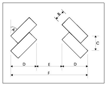
(f) The minimum parking space and aisle dimensions for the most common parking angles are shown in Table 6-3. For parking angles other than those shown on the chart, the minimum parking space and aisle dimensions shall be approved by the county engineer.
(g) Owners of two or more adjoining uses, structures or lots may utilize jointly the same parking or loading area when the hours of operation do not overlap. In the event that owners of one or more adjoining uses, structures or lots desire to utilize jointly the same parking concurrently, the total requirement for parking spaces shall be the sum of the requirements for each individual use, unless the applicants can demonstrate to the administrator that a lower number of parking spaces are justified through implementation of transportation demand management strategies, off-peak use, availability and use of public transit or alternative modes of travel or other measures.
(h) If lighting is provided, it shall be designed to minimize direct illumination of abutting properties and adjacent streets.
(2) Parking Access Standards. All parking facilities shall be developed consistent with the following access standards:
(a) Joint accesses for commercial, industrial and multifamily residential uses should be utilized whenever feasible.
(b) All ingress and egress to a parking lot accessing an arterial or collector roadway shall be developed so vehicles entering and leaving the parking lot are headed in a forward motion.
(c) Access points shall be located in a manner consistent with the standards of the Jefferson County department of public works or WSDOT, where applicable.
(d) Limited access provisions shall be required when deemed necessary by the Jefferson County department of public works or WSDOT, where applicable.
(3) General Off-Street Parking Construction Standards.
(a) All required off-street parking shall be provided with an all-weather surface as required by the Jefferson County department of public works.
(b) Grading work for parking areas shall meet the requirements of the International Building Code. Drainage and erosion or sedimentation control facilities shall be provided in accordance with JCC 18.30.060(2) and 18.30.070.
(c) Wheel stops, striping, or similar measures are required where a parked vehicle would encroach on adjacent property, pedestrian access or circulation areas, rights-of-way, or landscaped areas.
(d) Any lighting installed in parking areas shall be consistent with the requirements of JCC 18.30.140.
|
Land Use |
Minimum Number of Parking Spaces Required(1) |
|---|---|
|
COMMERCIAL USES |
|
|
Animal shelters, commercial kennels and catteries |
1 per 750 square feet plus 1 per employee |
|
Automotive service and repair |
2 spaces per bay or stall plus 1 space per employee |
|
Bed and breakfast inn or residence |
1 per guest room, plus 2 per facility |
|
Day care, group care, and residential care facilities |
1 space per 10 people enrolled plus 1 for each staff member or volunteer on-site, but not fewer than 3 spaces |
|
Drinking and/or eating establishments |
1 per 100 square feet or 1 per 3 seats, whichever is greater. Seasonal outside seating does not require additional parking |
|
Hotel/motel |
1 per guest room plus 1 per employee |
|
Indoor entertainment facilities |
1 per 4 seats or per 100 square feet of assembly area, whichever is greater |
|
Nursing homes/assisted living facilities |
5 plus 1 per 6 beds |
|
Personal and professional services and offices |
1 space per 300 square feet plus 1 per employee, but not fewer than 3 spaces |
|
Retail sales and services |
1 per 300 square feet |
|
Unnamed commercial uses |
[Determined by the administrator] |
|
Industrial Uses |
|
|
For all industrial uses (except as listed below) |
1 per employee plus 1 per 300 square feet of any associated retail sales area |
|
Heavy equipment rental services |
1 per 750 square feet plus 1 per employee |
|
Recycling center |
1 per 750 square feet plus 1 per employee |
|
Solid waste handling facilities |
1 per 750 square feet plus 1 per employee |
|
INSTITUTIONAL USES |
|
|
College or technical school/adult education facility |
1 per classroom, plus 1 per 2 students |
|
Community club or community organization facility |
1 space per 300 square feet but not fewer than 5 spaces |
|
Emergency services |
[Determined by the administrator] |
|
Government offices |
1 space per 300 square feet but not fewer than 5 spaces |
|
Library |
1 per 300 square feet |
|
Museum |
1 per 800 square feet |
|
Post office |
1 space per 300 square feet but not fewer than 5 spaces |
|
Religious assembly facility |
1 per 5 fixed seats, plus 1 per 50 square feet of gross floor area without fixed seats used for assembly purposes |
|
School, primary and secondary |
1 per 10 students enrolled plus 1 per employee |
|
Unnamed institutional uses |
[Determined by the administrator] |
|
SMALL-SCALE RECREATIONAL AND TOURIST USES |
|
|
For all small-scale recreational and tourist uses |
[Determined by the administrator] |
|
Unnamed small-scale recreational and tourist uses |
[Determined by the administrator] |
|
RESIDENTIAL USES |
|
|
Cottage industry |
1 per each employee (see JCC 18.20.170(5)(d); customer spaces determined by administrator) |
|
Group homes |
1.5 per tenant |
|
Home business |
2 per dwelling unit for each home business |
|
Mobile home parks |
2 per dwelling unit |
|
Multifamily residential (3+ units) |
1.5 per dwelling unit |
|
Single-family residential unit |
2 per dwelling unit |
|
Two-family residential (duplex) |
2 per dwelling unit |
|
Unnamed residential uses |
[Determined by the administrator] |
|
TRANSPORTATION USES |
|
|
All transportation-related uses |
[Determined by the administrator] |
|
UTILITIES USES |
|
|
All utilities and related uses |
[Determined by the administrator] |
|
AGRICULTURAL USES |
|
|
Agricultural activities |
None |
|
Accessory uses |
Parking fully accommodated on-site, unless otherwise permitted |
|
Forest products, processing activities |
1 per employee |
|
Nurseries |
1 per employee |
|
Unnamed agricultural uses |
[Determined by the administrator] |
Note:
1. At least one parking space must be provided, unless indicated by “None.”
|
Parking Angle (A) |
Stall Width (B) |
Curb Length (C) |
Stall Depth (D) |
Aisle Width (E) |
Unit Depth (F) |
||
|---|---|---|---|---|---|---|---|
|
1-Way |
2-Way |
1-Way |
2-Way |
||||
|
0 |
9.0 |
22.5 |
9.0 |
12.0 |
20.0 |
30.0 |
38.0 |
|
45 |
9.0 |
12.5 |
17.5 |
14.0 |
20.0 |
49.0 |
55.0 |
|
60 |
9.0 |
10.5 |
18.0 |
18.0 |
20.0 |
54.0 |
56.0 |
|
90 |
9.0 |
9.0 |
18.0 |
23.0 |
26.0 |
59.0 |
62.0 |
[Ord. 14-18 § 4 (Exh. B); Ord. 8-06 § 1]
18.30.110 Off-street loading space requirements.
Every nonresidential building used for retail, wholesale, manufacturing, or storage activities, excluding self-service storage facilities, shall provide off-street loading spaces in accordance with the standards listed below:
(1) One loading space shall be required for each building containing 7,500 or more square feet of gross floor area.
(2) Each loading space must be a minimum of 10 feet wide, 25 feet long, have an unobstructed vertical clearance of 14 feet, six inches, and be surfaced, improved, and maintained as required by this section. Loading spaces must be located so that trucks do not obstruct pedestrian or vehicle traffic movement or project into any public right-of-way. All loading space areas shall be separated from required parking areas and shall be designated as truck loading spaces.
(3) Any loading space located within 100 feet of areas designated for residential use shall be screened and operated as necessary to reduce noise and visual impacts. Noise mitigation measures may include architectural or structural barriers, beams, walls, or restrictions on the hours of operation.
(4) Loading areas and dumpsters shall be screened from adjacent residential uses by walls, trellises, arcades, or landscaping. [Ord. 8-06 § 1]
18.30.120 Utility service lines and facilities.
(1) General Regulations.
(a) Environmental impacts resulting from installation or maintenance of utilities should be minimized. Areas disturbed during construction shall be replanted with native vegetation and maintained until firmly established. Clearing shall be confined to that necessary to allow installation and to prevent interference by vegetation once the system is in operation.
(b) Utilities and transportation facilities should be installed in the same rights-of-way when the effect will be to reduce the adverse impacts on the physical environment.
(c) Solid waste transfer and disposal facilities shall be located and designed in accordance with Chapter 173-301 WAC, Department of Ecology Minimum Functional Standards for Solid Waste Handling, and applicable local health, safety, and fire protection codes. [Ord. 8-06 § 1]
18.30.130 Landscaping/screening.
(1) Application. Landscaping or screening shall be provided for all multifamily residential, commercial and industrial land uses, small-scale recreational and tourist uses, and as required in other sections of this code, except that landscaping will not be required of industrial uses within the resource-based industrial district when the development is sufficiently screened from public view.
(2) General Provisions.
(a) Existing trees, vegetative plantings, undisturbed open space, and/or topographic or natural features which meet or exceed these standards shall be considered to fulfill the landscaping or screening requirements of this section and any other applicable reference to these screening requirements in other sections of this code.
(b) The administrator may authorize variations to the landscaping/screening requirements of this section to:
(i) Provide consideration of topography, natural features, existing native vegetation and soils on the site and site location in relation to adjacent and surrounding uses;
(ii) Allow alternative plant mixes or berming that accomplish the purposes of the type of landscape screening required;
(iii) Conserve water through the concept of xeriscaping;
(iv) Provide flexibility in the size of initial plantings; and
(v) Ensure that any nonresidential use, structure or activity when proposed in a rural residential (RR) district shall be compatible with that of existing and anticipated future uses in the district.
(3) Landscape Screening. The three types of landscaping screens are described and applied as follows:
(a) “Screen-A” landscaping:
(i) Is a “full screen” that functions as a visual barrier. This landscaping is typically found between residential and nonresidential areas;
(ii) Shall at a minimum consist of a mix of primarily evergreen trees and shrubs generally interspersed to form a continuous year-round screen that grows to at least eight feet in height within two growing seasons.
(b) “Screen-B” landscaping:
(i) Is a “filtered screen” that functions as a visual separator. This landscaping is typically found between commercial and industrial uses; between differing types of residential development; and to screen industrial uses from the road;
(ii) Shall at a minimum consist of a mix of evergreen and deciduous trees and shrubs generally interspersed to create a filtered screen that grows to at least eight feet in height within two growing seasons.
(c) “Screen-C” landscaping:
(i) Is a “see-through screen” that functions as a partial visual separator to soften the appearance of parking areas and building elevations. This landscaping is typically found along road frontage or between multiple-family developments;
(ii) Shall at a minimum consist of a mix of evergreen and deciduous trees or shrubs generally interspersed to create a continuous canopy.
(4) Landscaping Road Frontages. The average width or depth of perimeter landscaping along road frontages and required locations on private property shall be as follows:
(a) Ten feet of Screen-B landscaping shall be provided for an industrial development.
(b) Ten feet of Screen-B landscaping shall be provided for all above-ground utility facilities or development, excluding distribution and transmission corridors, located outside a public right-of-way.
(c) Ten feet of Screen-C landscaping shall be provided for all commercial or multiple-family residential development.
(d) Within the highway visual corridor overlay, Article VI-Q, a 30-foot vegetated buffer providing Screen-A landscaping is to be located adjoining State Route 20, along with a 20-foot setback from the buffer, totaling a 50-foot visual corridor meeting the purpose and requirements of JCC 18.15.574.
(5) Landscaping of Interior Lot Lines. The average width or depth of perimeter landscaping along interior lot lines shall be provided as follows:
(a) Fifteen feet of Screen-A landscaping shall be included in all commercial, industrial, or small-scale recreational and tourist development along any portion adjacent to a residential use or district, except as may be varied by the administrator under subsection (2)(b) of this section.
(b) Ten feet of Screen-B landscaping shall be included in all multiple-family development along any portion adjacent to a single-family residential use and in an industrial development along any portion adjacent to a nonindustrial development, except as provided in subsection (5)(a) of this section.
(6) Screening1 for Parking Lots. Screening shall be provided for commercial, industrial, small-scale recreational and tourist uses, and multifamily residential use surface parking lots, with five or more parking stalls, as follows:
(a) Parking lot screening shall be provided on each side, front, and/or rear of a parking lot where such side, front, or rear abuts any residential use or district, except that no screening is required where the elevation of the parking area lot line is four feet higher than the finished elevation of the parking area surface.
(b) Parking lot screening shall be kept in good condition and shall meet the following conditions:
(i) Parking lot screening shall be continuous where required along a side, front or rear of a parking area and shall not be less than four feet in height above the grade of the parking lot surface, broken only for accessways and aisles; provided, that the screening shall not be permitted for a distance of 20 feet on each side of a parking area accessway to ensure proper sight distance. Where screening is prohibited by the above provisions, low lying shrubs or other similar plantings shall be placed; such plantings shall not be allowed to exceed three feet in height.
(ii) Parking lot screening shall not be installed in such a manner as to obstruct the free use of any fire hydrant.
(iii) The space between a parking lot screen and the right-of-way, except for any pedestrian access improvements, shall be landscaped with grass, shrubs, trees, or evergreen ground cover. On the sides and rear of parking areas not facing a street, such landscaping shall be required between the screening and the lot line.
(7) Landscape Plan. When screening is required, a landscaping plan shall be submitted with the project application to indicate how the minimum screening requirements are met. The plan must meet the following requirements:
(a) The landscape plan shall be drawn on the same base map as the development plans or on a separate sheet properly labeled and shall identify the following:
(i) Total landscape area;
(ii) Landscape materials, plant names, and applicable size;
(iii) Property lines;
(iv) Impervious surfaces;
(v) Existing or proposed structures, fences, and retaining walls; and
(vi) Natural features or vegetation left in natural state.
(b) The required landscaping shall be installed prior to project occupancy. However, a certificate of occupancy may be issued prior to installation of the required landscaping if a bond or other form of appropriate surety is posted in a manner acceptable to the administrator. The time limit for compliance may be extended to allow installation of such required landscaping during the next planting season.
(8) Maintenance.
(a) All landscaping and necessary support systems shall be maintained for the life of the project.
(b) All landscape materials shall be pruned and trimmed as necessary to maintain a healthy growing condition.
(c) Landscape areas shall be kept free of trash. [Ord. 11-23 § 8 (Att. A); Ord. 8-06 § 1]
18.30.140 Lighting.
(1) Exterior Lighting. Exterior lighting shall not exceed 30 feet in height from the finished grade for commercial and industrial uses, and 20 feet for residential uses (except when such lighting is an integral part of the building). Exterior lighting shall be energy-efficient and shielded or recessed so that direct glare and reflections are contained within the boundaries of the parcel. Exterior lighting shall be directed downward and away from adjoining properties and public rights-of-way. No lighting shall blink, flash, or be of unusually high intensity or brightness. All lighting fixtures shall be appropriate in scale, intensity, and height to the use they are serving. Any lighting installed in parking areas shall be of direct cutoff design so that the source is not visible from adjacent property.
(2) Street Lighting. Street lighting may be provided by private parties on county roads, provided the design and location shall be approved by the county engineer, and a method to cover the cost of operation and maintenance is approved by the county engineer. [Ord. 8-06 § 1]
18.30.150 Signs.
(1) Purpose. These regulations are intended to balance the need to protect public safety and welfare, the need for a well-maintained and attractive community, and the need for adequate methods of communication through signs. Specific objectives are:
(a) To allow for and encourage the effective use of signs;
(b) To improve and maintain traffic and pedestrian safety by reducing distractions and hazards from signs;
(c) To maintain public and private property values, scenic resources and “rural character” in accordance with the adopted comprehensive plan;
(d) To ensure that the constitutionally guaranteed right of free expression is protected;
(e) To disavow any regulatory distinctions or restrictions on speech based on the content of signs. No part of this section shall be construed to favor one type of speech over another and if any provision of this section is ambiguous, it shall be interpreted as to not regulate on the basis of speech content.
(2) Applicability. No sign shall hereafter be erected or used for any purpose or in any manner except as permitted by the regulations of this section or as specified elsewhere in this code. All non-exempt signs shall be subject to review and approval and may require issuance of a sign permit and or a building permit by the administrator according to a Type I permit approval process as specified in Chapter 18.40 JCC.
(3) Definitions.
(a) “Abatement” means to repair, fix, rebuild, demolish and/or remove any sign or sign structure to remove any feature that is noncompliant with this section.
(b) “Abandoned sign” means any sign that, for a period of more than six months, no longer correctly identifies, exhorts, or advertises any person, business, product, event or activity conducted or available on or off the premises on which the sign is located.
(c) “Administrator” means the planning manager of the Jefferson County department of community development or his/her designee.
(d) “Banner sign” means a temporary sign composed of lightweight, flexible, nonrigid material either enclosed or not enclosed in a rigid frame.
(e) “Billboard sign” means any outdoor sign containing advertising which is not related to any use or activity on the premises on which the sign is located, but not including directional signs as defined in this title.
(f) “Commercial sign” means signs that exhort a viewer to patronize a business.
(g) “Community signs” mean signs which identify a recognized community or unincorporated place.
(h) “Directional sign” means a sign which serves solely to designate the location of any place, area, organization, or businesses, whether on premises or off premises.
(i) “Changing message sign” means a type of “moving sign” where only the display of words, symbols, graphics or images can be electronically or mechanically changed by remote or automatic means, and where the image and/or message remains fixed for at least three seconds, and where only the changing message exhibits movement and where the brightness or illuminance of the sign does not exceed 0.3 foot-candles above ambient light as measured during the night between the hours of 10:00 p.m. to 2:00 a.m. using a foot-candle meter at a preset distance depending on sign size. The measuring distance in feet shall be determined by the product of the square root of the sign area and 100. In addition, illuminated moving signs
with changing messages shall be equipped with automatic dimming technology which automatically adjusts brightness due to ambient light conditions.
(j) “Event signs” means signs and banners promoting public festivals, community or special events, and grand openings.
(k) “Foot-candle” means a unit of luminance or illumination, equal to one lumen incident per square foot.
(l) “Freestanding sign” means a sign which is supported by one or more permanent uprights, pole or braces to the ground and which is not connected to a building. Freestanding signs include “monument signs,” meaning a sign attached to a solid base measuring 50 percent or more of the total sign width and which connects the sign to the ground.
(m) “Governmental sign” means a sign installed or placed by any political subdivision, municipal corporation or junior taxing district of the state or any entity having taxing authority granted to it by state statute.
(n) “Hand held sign” means a sign held or worn by a person.
(o) “Moving sign” means signage that exhibits movement, including inflatable structures, fluttering material, revolving or moving parts or lights to provide motion or the optical illusion of motion, animation or changing images. Moving signs may employ one or more of the following methods to provide motion or the illusion of motion: (i) naturally occurring energy, such as the wind; (ii) electrical energy; (iii) mechanical energy; or (iv) human power.
(p) “Nonconforming sign” means any sign in existence within the county on the date of adoption of the ordinance codified in this section which does not conform with the provisions of this section, but which did conform to all applicable laws in effect on the date the sign was originally erected.
(q) “Noncommercial signs” means signs that do not exhort a viewer to patronize a business, including, but not limited to, political signs as that term is defined in this section.
(r) “On-site sign” means a sign relating, through its message and content, to an activity, use, product, or service which is available on the premises on which the sign is erected.
(s) “Off-site sign” means a sign relating, through its message and content, to an activity, use, product, or service which is not available on the premises on which the sign is erected.
(t) “Political sign” means any sign which serves to influence, is intended to influence, or appears to be the type of sign which is commonly erected to influence the results of an election or ballot proposition.
(u) “Portable sign” means any sign which is not permanently affixed to the ground or a structure or building. This definition includes movable reader boards, banners and sandwich boards that are placed so as to be seen from private property or public rights-of-way.
(v) “Projection sign” means a sign that is wholly or partly dependent upon a building for support and which projects more than 12 inches from such building.
(w) “Real estate sign” means a temporary sign which directs attention to the sale, lease, or rental of a particular building, property, or premises, whether located at the premises to be sold, leased or rented or not.
(x) “Roof base” means the point at which the walls of a building meet the roof structure, excluding any eaves, parapets, cupolas, chimneys, towers, other projections, and any roof height caused by the pitch of a roof.
(y) Sandwich Board Sign. See “portable sign.”
(z) “Sign” means any object, device, display or structure, or part thereof, situated outdoors which is used to advertise, identify, display, direct or attract attention to an object, person, institution, organization, business, product, service, event or location by any means, including words, letters, figures, design, symbols, fixtures, colors, illumination or projected images. Excluded from this definition are signs required by law, such as handicapped parking signs, and the flags of national and state governments.
(aa) “Subdivision real estate sign” means a temporary sign which directs attention to the sale, lease or rental of more than one lot, house or premises within a subdivision.
(bb) “Temporary sign” means a sign associated with a particular short-term event or activity, such as but not limited to community festival, parade, grand opening, garage or rummage sale, political campaign and real estate signs, which are to be removed within 10 days of when the event or activity ends. For political signs, as that term is defined in this section, election day shall be considered the measuring event. Temporary signs are limited to a maximum time of not more than 180 days in any one calendar year, unless otherwise noted.
(cc) “Wayfinding signs” means, upon its establishment by the county, a program of uniform signs that are designed, installed and maintained by the county intended to assist the public in finding goods, services, events and places. Private or public entities may be approved to locate their messages on the wayfinding signs, upon payment of a fee intended to defray the cost of the program.
(dd) “Use” means the purpose that land or building or structures now serve or for which they are or may be occupied, maintained, arranged, designed, or intended.
(4) Exemptions. The following signs are exempt from the requirements to apply for and receive a land use sign permit or building permit; provided, that exempt signs must meet all other applicable requirements of this section, and any other applicable requirements of this title:
(a) Traffic and standardized public signs installed by a government entity;
(b) Window and merchandise displays, point of purchase advertising displays such as product dispensers, illuminated displays located inside buildings and barber poles;
(c) National flags, flags of a political subdivision, and symbolic flags of an institution or business;
(d) Legal notices required by law;
(e) Historic site plaques and markers and gravestones;
(f) Noncommercial signs on private property;
(g) Structures with messages or lettering affixed and intended for separate use, such as recycling containers and phone booths;
(h) Real estate signs;
(i) Signage of any kind affixed to any licensed motorized vehicle;
(j) Seasonal displays or decorations, which are clearly incidental and customary and commonly associated with any national or local event, occasion or holiday or religious or cultural observance;
(k) Murals or signs consisting solely of paint or other colored media that is applied on existing structures;
(l) Portable signs;
(m) Temporary signs.
(5) Prohibited Signs. The following signs are prohibited:
(a) Abandoned signs;
(b) Billboard signs;
(c) Moving signs, excepting signs where the movement is induced entirely by naturally occurring causes, such as the wind or human power, and also excepting signs that display changing messages, may be allowed pursuant to subsection (6)(c) of this section;
(d) Off-site signs which advertise a business; except as provided in subsection (6)(m) of this section;
(e) Signs or sign structures which by coloring, shape, working, or location resemble or conflict with traffic-control signs or devices;
(f) Signs which impede or create a safety hazard for pedestrians or vehicular traffic;
(g) Signs attached to utility poles or traffic signs, except with the permission of the utility or agency;
(h) Signs shall not be placed in the public right-of-way, except for governmental signs, portable signs and temporary signs as defined in subsection (3) of this section and as further regulated in subsections (6) and (8) of this section; and
(i) Signs that are not in compliance with this section.
(6) Design Standards. All signs must meet the following standards:
(a) The illumination of signs shall be shaded, shielded, or directed so the light intensity or brightness shall not adversely affect surrounding properties or public and private rights-of-way or create a hazard or nuisance to the traveling public, or to surrounding properties.
(b) No sign or part thereof shall consist of rotating, revolving, or moving parts; consist of banners, streamers, or spinners; or involve flashing, blinking, or alternating lights; provided, that exceptions to this standard are temporary signs associated with local festivals, fairs, parades, or special events pursuant to subsection (8)(b) of this section; moving signs where the movement is induced wholly by naturally occurring causes, such as wind or human power; and changing message signs allowed pursuant to subsection (6)(c) of this section.
(c) Changing message signs are allowed only in rural commercial, rural industrial, urban commercial, and master planned resort commercial zones and must be directed away from adjacent property zoned residential or open space, including properties across a public right-of-way; except that changing message signs which are also governmental signs, as defined elsewhere in this code, are allowed in other zoning designations not listed here, through a conditional use permit (C) process, if the parcel where the proposed changing message sign would be built, installed or placed is owned by a municipal corporation or other public entity, and the sign is placed or installed within 150 feet of the logical outer boundary of a LAMIRD. No changing message sign may be located closer than 200 feet from adjacent property zoned residential or open space, as measured from the sign location to the nearest property line of the residential or open space zoned property; provided, that a changing message sign may be closer than 200 feet to a residential or open space zone with review and approval through a conditional discretionary use permit process (C(d)) if proposed by a nongovernmental entity, or with review and approval through a conditional use permit (C) process if proposed by a governmental entity as described above.
(d) For any uses within any rural commercial, rural industrial, resource, public or UGA land use district, the total square footage of signs shall not exceed 64 square feet; provided, that any sign size may be increased up to 50 percent larger than the standard size, upon approval of the administrator, based on a finding that the larger sign size is consistent with the provisions of subsection (1) of this section. Multitenant developments may have one freestanding sign for each access point, commonly identifying the businesses within multitenant developments, provided such signs total no more than 64 square feet in aggregate. The maximum aggregate size for projection signs placed on a building is limited to one percent of the floor areas of the building, except that each occupant is allowed a sign of at least two square feet. In no case may an individual occupant’s sign be larger than 15 square feet. The size of signs in square footage shall be calculated by the outside dimensions necessary to frame the information displayed. Any sign projecting beyond six inches from a perpendicular wall shall be at least eight feet above grade as measured from the ground to the bottom of the sign.
(e) Signs for any use located in any rural residential district shall not exceed 32 square feet of total sign area, with the exception of government signs, including community signs, which shall not exceed 64 square feet; provided, that any sign size may be increased up to 50 percent larger than the standard size, upon approval of the administrator, based on a finding that the larger sign size is consistent with the provisions of subsection (1) of this section.
(f) Uses located in any rural commercial, rural industrial, resource, public or UGA land use districts shall have no more than two on-site signs, except as allowed in this section for multitenant developments; provided, that the number of signs may be increased upon approval of the administrator, based on a finding that the increased number of signs is consistent with provisions of subsection (1) of this section. In no event shall the number of signs that may be added by the administrator for a particular parcel exceed the lesser of four signs or the least number of additional signs that would equal or exceed 100 percent of the signs that may be lawfully placed at that parcel prior to the administrator authorizing for the first time any additional signs. While an applicant may make more than one request for bonus signs, the maximum number of bonus signs available for authorization at a particular parcel shall never exceed four in addition to those lawfully allowed before the administrator authorized any bonus signs at that parcel.
(g) All signs shall be maintained to be structurally sound, so as to not present a public hazard. Pursuant to subsection (5)(f) of this section, signs that present a public hazard are prohibited and shall be subject to abatement.
(h) The design of freestanding signs shall include measures to restrict vehicles from passing beneath them. All freestanding pole signs or projecting signs shall provide pedestrian clearance to a minimum of eight feet, as measured from the ground to the bottom of the sign, where applicable.
(i) No signs located on property immediately adjacent to bodies of water, other than those related to water dependent uses, such as a marina, or noncommercial signs on private property, are permitted to face waterward, excepting governmental signs and signs relating to safety concerns, such as cable-crossing, construction-dredging, fuel area, etc.
(j) No sign shall be placed in a way as to obstruct a driver’s vision of motor vehicle traffic, bicyclists or pedestrians, or traffic signs.
(k) Community signs are permitted at each entrance to the community. Said signs are limited to one per entrance, and may not exceed 64 square feet in area or eight feet in height as measured from the ground to the top of the sign. Signs relating to clubs, societies, orders, fraternities and the like shall be permitted as part of the community sign.
(l) Portable sandwich board signs subject to the following criteria:
(i) No more than two sandwich board signs may be erected per business;
(ii) Sandwich board signs shall not exceed three feet in width and four feet in height, from the ground to the top of the sign;
(iii) Sandwich board signs shall be displayed during business hours only;
(iv) Sandwich board signs, where located on sidewalks, shall provide a minimum of 36 inches of continuous horizontal clear space between the sign and any building or the edge of the sidewalk, to provide for the free passage of pedestrian traffic; and
(v) Sandwich board signs shall have a maximum area per side of 12 square feet.
(m) Off-site signs may only be allowed when they meet all of the following standards:
(i) Are directional in nature as defined in subsection (3)(h) of this section;
(ii) Located on private property along a major or minor arterial;
(iii) Located not less than 600 feet from an intersection;
(iv) No larger than 32 square feet for noncommercial signs and not more than six square feet for commercial signs. Noncommercial signs, except for government signs, are limited to a maximum height above ground of eight feet, from the ground to the top of the sign; and
(v) Only three off-site directional commercial signs per commercial destination may be allowed; not more than eight feet tall, as measured from the ground to the top of the sign; not more than six square feet in sign area, and located not more than 1,320 linear feet from the turn-off to the destination of the sign; and, if applicable, one sign located at the nearest “T” intersection on the same road to the commercial destination.
(n) Banner signs shall be no larger than 64 square feet and not placed on utility poles without the permission of the utility. Banner signs placed over roadways, including the height above the roadway, must have approval of the appropriate roadway managing agency.
(o) Hand held signs shall not exceed 16 square feet; provided, that the size may be increased up to 50 percent larger than the standard size, upon approval of the administrator, based on a finding that the larger size is consistent with provisions of subsection (1) of this section.
(p) Unless otherwise stated in this section, the maximum height in feet above the ground to the top of the sign for any sign attached to a building on any parcel of land zoned rural commercial, rural industrial, resource, public or UGA is the sum of the square root of the maximum sign size in square feet for the sign type and the land use zone as identified in this section, plus the height of the building at the roof base. For example, for a building 20 feet high to the roof base and an allowable sign size of 32 square feet, the maximum sign height would be: square root of 32 feet = 5.6 feet + 20 feet = 25.6 feet above ground level.
(q) Unless otherwise stated in this section, the maximum height in feet above the ground for any on-site sign not attached to a building on any parcel of land zoned rural commercial, rural industrial, resource, or urban commercial is 35 feet from the ground to the top of the sign.
(r) Unless otherwise stated in this section, the maximum height in feet above the ground for any sign in a rural residential zone is eight feet from the ground to the top of the sign.
(7) Nonconforming Signs. Legally established signs in place prior to the adoption of these standards and not in conformance with these standards shall be considered legal, nonconforming signs, and may remain as provided below:
(a) Legal nonconforming off-site signs shall be removed within five years of adoption of an ordinance establishing a “wayfinding sign” program, which is intended to provide off-site sign locations where businesses can place signs. Until adoption of a wayfinding sign ordinance, legal nonconforming signs must be continually maintained, not relocated, and not structurally altered. Nonconforming off-site signs may be replaced by off-site directional signs as allowed in subsection (6)(m) of this section.
(b) Legal nonconforming on-site signs may remain provided they are continually maintained, not relocated, and not structurally altered.
(8) Temporary Signs. Temporary signs are exempt from the requirements to obtain a sign permit, subject to the following standards:
(a) Temporary signs shall be limited in size to 64 square feet; except that temporary signs in the public right-of-way are subject to size and height limits of subsection (8)(g) of this section and shall not obstruct safe visibility of any motorist or pedestrian traffic. Temporary signs shall be secured in their location so as to not collapse, become airborne or otherwise cause a safety hazard. Temporary signs, except for banner signs placed across roadways, and signs mounted within the public right-of-way, shall not exceed eight feet in height from the ground to the top of the sign.
(b) Event signs and banners promoting public festivals, community or special events, and grand openings may be displayed for up to 30 days prior to the event and shall be removed no later than 10 days after the event. The sponsoring entity is responsible for sign removal. Event signs may be located “off site.” To ensure consistency with this section, “event” signs subject to the requirements of Chapter 8.20 JCC shall be reviewed by the administrator for a “special event permit.”
(c) Garage or rummage sale signs may be displayed for up to seven days prior to the event and shall be removed no later than one day after the event.
(d) Political signs may be displayed upon the date of official filing of a candidate for elective office or upon certification by the county of a ballot measure, and must be removed not later than 10 days after the final election for the candidate or ballot measure.
(e) Real estate signs may be displayed upon execution of a formal listing agreement between seller and real estate agent, or a listing “for sale by owner,” and removed within 10 days of either: (1) the date the new owner or lessee takes possession of the property, or (2) the date of the expiration of the listing, and (3) shall not be more than 12 square feet in size and not exceed eight feet above existing grade, as measured from the ground to the top of the sign.
(f) Subdivision Real Estate Sales Signs. Real estate signs advertising the sale of lots or dwelling units located within an approved subdivision shall be permitted; provided, that there shall be no more than one sign per subdivision entrance, and each sign shall be no greater than 32 square feet in area and no greater than eight feet in height, as measured from the ground to the top of the sign. These signs shall be removed within 10 days following the initial sale of all lots or dwelling units within the subdivision.
(g) Temporary signs and portable signs in the public right-of-way, excepting governmental signs, must not exceed four square feet in size, not exceed three feet above existing grade to the top of the sign and must include the name and contact information of the party posting the sign and must be removed by the party who posted the sign or their agent not later than 10 days after the sign is no longer serving its purpose, including but not limited to the end of the temporary event, festival, election, or sale. All nongovernmental signs in the public right-of-way are limited to a maximum of 180 days per calendar year.
(9) Signs along State Highways. All signs along state highways in Jefferson County are also subject to any sign regulations and permit requirements established by the state of Washington.
(10) Substitution. Noncommercial signs are allowed in all districts and may be substituted for any sign expressly allowed under this code. [Ord. 14-18 § 4 (Exh. B); Ord. 1-16 § 1; Ord. 10-14 § 1 (Att. A)]
18.30.160 Archaeological and historic resources.
(1) When an application for a permit is received for an area known to contain archaeological artifacts and data as identified by appropriate state, federal or tribal agencies, the county shall not take action on the application and shall inform the applicant thereof, and the applicant shall not initiate any excavation or development activity until the site has been inspected and a written evaluation is provided by a qualified archaeologist. Significant archaeological data or artifacts must be recovered before work begins or resumes on a project. No application will be delayed more than 10 working days for such an inspection. If the application is approved by the county, conditions shall be attached reflecting the recommendations of the archaeologist regarding preservation or protection of the site.
(2) All permits shall contain a special provision advising the permit holder that if during excavation or development of the site an area of potential archaeological significance is uncovered, all activity in the immediate vicinity of the find must be halted immediately and the administrator must be notified at once. Activities authorized by the permit will not be delayed more than five working days for a finding of significance by the administrator, following the administrator’s receipt of notification, unless the permit holder agrees to an extension of that time period.
(3) All development proposed for location adjacent to sites which are listed, or are determined by the appropriate state or federal authority to be eligible for listing in the state or national registers of historic places, must be located so as to complement the historic site. Development which degrades or destroys the historical character of such sites is not permitted.
(4) Archaeological sites are subject to Chapter 27.44 RCW (Indian Graves and Records) and Chapter 27.53 RCW (Archaeological Sites and Records) and must comply with Chapter 25-48 WAC (Archaeological Excavation and Removal Permit). Archaeological excavations are allowed subject to applicable state laws.
(5) Identified historical or archaeological resources must be considered in site planning for public parks, public open space, and public access and site planning, with access to such areas designed and managed so as to give maximum protection to the resource. [Ord. 8-06 § 1]
18.30.170 Mining, quarrying and asphalt/concrete batch plant best management practices in critical aquifer recharge areas.
The following shall be considered minimum development standards necessary only for mineral extraction, quarrying and asphalt/concrete batch plant operations located in susceptible aquifer recharge areas or special aquifer recharge protection areas as defined in Article VI-E of Chapter 18.15 JCC. See also the performance and use-specific standards requirements of JCC 18.20.070 (Asphalt and Concrete Batch Plants) and JCC 18.20.240 (Mineral Extraction, Mining, Quarrying and Reclamation) for general mining, quarrying and asphalt/concrete batch plant operations. Asphalt batch plants are prohibited in special aquifer recharge protection areas (JCC 18.15.250(1)(b)).
(1) Best Management Practices.
(a) Concrete and Asphalt Production at Stationary Sites. This activity applies to any activity that mixes raw materials on-site to produce or enhance concrete or asphalt. It also applies to subsequent activities such as pouring concrete structures, and making other concrete and asphalt products. Mishandling of raw materials on concrete production can introduce suspended solids and heavy metals to stormwater runoff and cause pH increases in receiving waters. In addition, stormwater pollution can result from washing of waste concrete from trucks, forms, wheelbarrows, buckets, and other equipment in the work area. The loose chunks of aggregate resulting from washing of equipment can easily reach storm drains, either in the wash water itself or in stormwater runoff. Asphalt emulsion and chunks of aggregate can easily wash off of equipment used in mixing and production in a similar manner as concrete. Mobile concrete pouring and asphalt application are covered under a separate activity in these administrative rules. Concrete production at mining sites is also covered by this activity.
(i) Minimum Requirements. The following BMPs, or equivalent measures, methods, or practices, are required if you are engaged in concrete and asphalt mixing and production:
(A) Discharge all process water from production, pouring, and equipment cleaning activities to a sump, process water treatment or recycling system, or sanitary sewer system.
(B) Contain the production and pouring area to prevent stormwater from entering the area and carrying pollutants away.
(C) Routine maintenance.
(I) Sweep the production and pouring areas weekly, if it is paved, to collect loose chunks of aggregate and raw material particles for recycling or proper disposal.
(II) Do not hose down area to a storm drain.
(ii) Additional BMPs. The following BMPs, intended to provide improved pollution control, may be required of an applicant by the administrator in a manner consistent with Chapter 18.40 JCC:
(A) Use an oil control device in the catch basins to treat stormwater runoff.
(B) Cover the production area with provisions for prevention of stormwater run on.
(C) Pave the mixing, production and/or pouring area(s) with a slope to a central collection area. For concrete production and pouring activities, a sump drain should not be provided because it would be quickly clogged with hardened concrete. It may not be wise to segregate the mixing and pouring area from the curing area because wastewater from curing applications could be collected by a drain. By sloping the pavement to a central location, loose chunks of concrete or asphalt aggregate can be collected more easily and recycled or disposed of properly.
(b) Storage of Liquid Materials in Stationary Tanks. This section applies to any activity that stores any type of liquid chemicals, waste oils, solvents, or petroleum products in above-ground storage tanks. Leaking tanks on these sites can contribute toxic compounds, oils and greases, heavy metals, abnormal pH, and nutrients to stormwater runoff. In addition, spills may occur during liquid transfer operations to and from the tanks.
This activity does not apply to underground storage tanks or to businesses permitted by the Washington State Department of Ecology to treat, store, or dispose of dangerous wastes. Storage of reactive, combustible, or flammable liquids must comply with the fire code requirements and may need to comply with the Washington State Department of Ecology regulations.
(i) Minimum Requirements. The following BMPs, or equivalent measures, methods or practices are required if you are engaged in storage of liquid materials in stationary tanks:
(A) Store and contain liquid materials in such a manner that if the tank is ruptured, the contents will not discharge, flow or be washed into the storm drainage system, surface waters, or groundwater.
OR
(B) If the liquid is oil, gas or other material that separates from and floats on water, install a spill control device (such as a tee section) in the catch basins that collect runoff from the storage tank area.
(C) Routine Maintenance.
(I) Place drip pans or absorbent materials beneath all mounted taps, and at all potential drip and spill locations during filling and unloading of tanks. Any collected liquids or soiled absorbent materials must be reused/recycled or properly disposed.
(II) Store and maintain appropriate spill cleanup materials in a location known to all near the tank storage area; and ensure that employees are familiar with the site’s spill control plan and/or proper spill cleanup procedures.
(III) Sweep and clean the storage area monthly if it is paved; do not hose down the area to a storm drain.
(IV) Check tanks (and any containment sumps) daily for leaks and spills. Replace tanks that are leaking, corroded, or otherwise deteriorating with tanks in good condition. Collect all spilled liquids and properly dispose of them.
(c) Storage of Any Liquid Material in Portable Containers. This section applies to any activity that stores any type of liquid chemicals, waste oils, solvents or petroleum products in portable containers (such as drums). This activity covers permanent storage as well as temporary storage areas at temporary sites. Spills and drips of these liquids, or overtopping of storage containers, can contribute toxic compounds, oils and greases, heavy metals, abnormal pH, and nutrients to stormwater runoff.
This section does not apply to businesses that are permitted by the Washington State Department of Ecology to treat, store, or dispose of dangerous waste. Storage of reactive, combustible, or flammable liquids must comply with the Washington State Department of Ecology regulations.
(i) Minimum Requirements. The following BMPs, or equivalent measures, methods, or practices, are required if you are engaged in storage of liquid materials in portable containers:
(A) Place tight-fitting lids on all containers.
(B) Enclose or cover the containers where they are stored. The local fire district must be consulted for limitations on clearance of roof covers over containers used to store flammable materials.
(C) Raise the containers off the ground by use of pallet or similar method, with provisions for spill control.
OR
(D) Contain the material in such a manner that if the container leaks or spills, the contents will not discharge, flow, or be washed into the storm drainage system, surface waters, or groundwater.
(E) Place drip pans or absorbent materials beneath all mounted container taps, and all potential drip and spill locations during filling and unloading of containers. Any collected liquids or soiled absorbent materials must be reused/recycled or properly disposed.
(F) Routine Maintenance.
(I) Store and maintain appropriate spill cleanup materials in a location that is known to all employees near the tank storage areas, and ensure that employees are familiar with the site’s spill control plan and/or proper spill cleanup procedures.
(II) Sweep and clean storage area monthly if it is paved; do not hose down the area to a storm drain.
(III) Check containers (and any containment sumps) daily for leaks and spills. Replace containers that are leaking, corroded, or otherwise deteriorating with ones in good condition. If the liquid chemicals are corrosive, containers made of compatible materials must be used instead of metal drums. New or secondary containers must be labeled with the product name and hazards.
(IV) Collect all spilled liquids and properly dispose of them.
(d) Storage of Soil, Sand, Salt and Other Erodible Materials. This section applies to stockpiling erodible raw materials such as soil, sawdust, gravel, sand and road de-icing salts. It covers permanent sites as well as temporary construction sites and other temporary locations. Raw material stockpiles can easily erode due to wind or precipitation and contribute suspended solids, nutrients, heavy metals, and abnormal pH to stormwater runoff.
(i) Minimum Requirements. The following BMPs, or equivalent measures, methods, or practices, are required if you are engaged in the storage or stockpiling of erodible material on a normal or temporary basis:
(A) Site and contain the stockpiles of raw material in such a manner so as to prevent off-site impacts of surface water runoff, erosion, and sedimentation.
(B) Routine Maintenance.
(I) Sweep paved storage areas monthly for collection and disposal of loose solid materials; do not hose down the area to a storm drain or conveyance ditch.
(II) Stock cleanup materials, such as brooms, dust pans, and vacuum sweepers (if desired) near the storage unit.
(ii) Additional BMPs. The following BMPs, intended to provide improved pollution control, may be required of an applicant by the administrator in a manner consistent with Chapter 18.40 JCC:
(A) A catch basin insert, configured for sediment removal, may remove some of the pollutants in runoff from this activity. (Catch basin inserts require frequent maintenance to be effective. Carefully consider this when making your decision.)
(e) Engine Repair and Maintenance. This activity applies to operations that conduct engine repair and maintenance in vehicles and other equipment. It also applies to mobile vehicle maintenance operations, such as at construction sites. This common activity can lead to immediate stormwater contamination if it is not done in a controlled manner. This activity can contaminate stormwater with toxic hydrocarbons, other toxic organic compounds, oils and greases, abnormal pH, and heavy metals. Related vehicle maintenance activities are covered under the following activity headings in these administrative rules: “Painting, Finishing, and Coating of Vehicles, Products and Equipment,” “Vehicle Washing and Stream Cleaning,” “Fueling Operations, and Vehicle and Equipment Parking and Storage.”
(i) Minimum Requirements. The following BMPs, or equivalent measures, methods, or practices, are required if you are engaged in engine repair and maintenance:
(A) If temporary work is being conducted outside, use tarp, ground cloth, or drip pans beneath the vehicle or equipment to capture all spills and drips. The collected drips and spills must be disposed of, reused, or recycled properly.
(B) If the work is done on a regular basis at a stationary business location, move the activity indoors.
(C) Routine Maintenance.
(I) Employees must be educated on proper handling and disposal of engine fluids.
(II) Store and maintain appropriate spill clean up materials in a location known to all; and ensure that employees are familiar with the site’s spill control plan and/or proper spill cleanup procedures (reusable cloth rags can be used to clean up small drips and spills instead of disposables; these can be washed by a permitted industrial laundry; do not clean them at home or a coin-operated laundry business).
(III) Sweep the maintenance area weekly, if it is not paved, to collect loose particles, and wipe up all spills with rags and other absorbent material immediately; do not hose down the area to a storm drain.
(ii) Additional BMPs. The following BMPs, intended to provide improved pollution control, may be required of an applicant by the administrator in a manner consistent with Chapter 18.40 JCC:
(A) Absorbent material such as pillows or brooms can be used around storm drains or in catch basins to absorb oil and other substances. A qualified disposal contractor must pick up used absorbent material containing oil or other engine fluids.
(B) A catch basin insert, configured for oil removal, may remove some of the pollutants in runoff from this activity. (Catch basin inserts require frequent maintenance to be effective. Carefully consider this when making your decisions.)
(f) Vehicle Washing and Steam Cleaning. This activity applies to operations that receive shipments of bulk liquid materials by truck or rail and transfer those liquids into storage tanks or containers or handle the truck or rail loading of liquid materials from tanks. Spills and drips of these liquids can potentially contribute toxic organic compounds, oils and greases, nutrients, heavy metals, and abnormal pH to stormwater runoff.
(i) Minimum Requirements. The following BMPs, or equivalent measures, methods, or practices, are required if you are engaged in vehicle washing and steam cleaning:
(A) It is allowable to rinse down the body of a vehicle, including the bed of a truck, with just water without doing any washwater control BMPs.
(B) If you wash (with mild detergents) on an area that infiltrates water, such as gravel, grass or loose soil, it is acceptable to let the washwater infiltrate as long as you only wash the body of the vehicles.
(C) However, if you wash on a paved area and use detergents or other cleaners, or if you wash/rinse the engine compartment or the underside of the vehicles, you must do one of the following options:
(I) Designate and pave wash area to wash all vehicles in. Discharge wash water from vehicle cleaning operations to a sanitary sewer, holding tank, or process treatment system or process through an enclosed recycling system. The local sewer authority may have limits on the types and amounts of pollutants, such as oil and heavy metals that can be discharged to a sanitary sewer. Absolutely no untreated wash water can enter storm drains.
OR
(II) Designate and pave wash area to wash all vehicles in. Use a storm drain cover or other effective method of preventing all wash and rinse water from entering a storm drain or other drainage system feature. All runoff from the activity must be collected from proper disposal to a sanitary sewer. A wet vacuum or pump can be used for this. There are several products commercially available that enable collection of runoff. This requirement also applies to mobile vehicle washing services.
OR
(III) Take the vehicles to a commercial car wash or use a mobile washing service that complies with either of the previous options.
(D) Designated wash area must be well-marked with signs indicated where and how washing must be done.
(E) Oil changes and other engine maintenance cannot be conducted in the designated washing area.
(g) Optional BMPs. The BMPs listed below are measures that should be considered at all times for improving pollution control. While these BMPs are not mandatory, applicants are encouraged to incorporate them in their plan for implementing BMPs, and the administrator may, in a manner that is consistent with Chapter 18.40 JCC, require that an applicant implement one, several or all of the BMPs listed in this section. Implementing one, some or all of these BMPs may reduce or eliminate the need to implement other more complex or costly BMPs.
(i) Locate activities as far as possible from surface drainage paths. Locating activities on high ground, far from drainage paths, ditches, gutters and storm drains allows more time to recognize spills and act to prevent water contamination.
(ii) Avoid the activity or reduce its occurrence. Often an alternative production process or material application process can be used to substitute for another, more polluting, process. Ideally, a polluting activity can be avoided altogether, or its frequency of occurrence reduced. An example is washing vehicles less often or taking vehicles to commercial car washes or detail shops rather than washing on-site.
(iii) Use less material. Improper disposal of excess material or increased application of materials simply because excess is available can cause pollution. Purchase only the amount of material that will be needed for foreseeable use. In most cases you will see cost savings in both purchasing and disposal.
(iv) Use the least toxic materials available. All applications of solid and liquid materials should use the least toxic products and raw materials available, whether in production; cleaning; pesticide applications; or other uses.
(v) Create and/or maintain vegetated areas near activity location. Grass and types of vegetation can filter out many pollutants in stormwater runoff. Vegetated areas should be maintained around areas where polluting activities occur, especially down slope of activity areas. Routine maintenance will keep vegetated areas healthy and capable of filtering pollutants.
(vi) Recycle as much as possible. Recycling is always preferable to disposal of unwanted materials. Leftover paints, finishes, cleaning materials, building materials, etc., may be used by someone else, so don’t throw them away. Contact a neighbor, friend, school, church, community group, theater group, etc., to see if your leftover materials can be used. Many empty containers and other common items are recyclable. Contact the Jefferson County Recycling Center for recycling options.
(vii) Educate others about stormwater pollution prevention. Educate your employees, business associates, contractors, family, and friends about stormwater pollution control. Encourage others to find solutions to stormwater pollution problems, and to continue learning about pollution control techniques.
(viii) Implement treatment BMPs. Treatment BMPs are used to remove pollutants from stormwater before being discharged from a site. These include oil separators and other catch basin inserts that control pollutants in the piped system and as well as numerous biological systems such as a biofiltration swales, infiltration, and constructed wetlands. These BMPs may be a preferred option in certain circumstances.
(2) Best Management Practices (BMP) Report Criteria. The following criteria shall apply when preparing a best management practices (BMP) report:
(a) The report shall be prepared by, or done under the direction of or designed by, a qualified person with demonstrated expertise in the industry or field as demonstrated by a statement of qualifications.
(b) The report will identify appropriate BMPs and how they will be employed to prevent degradation of groundwater. Examples of BMPs are found in subsection (1) of this section. All necessary technical data, drawings, calculations, and other information to describe application of the BMPs must be supplied.
(c) The report shall identify how the applicant will satisfy the requirements of the Dangerous Waste Regulations, Chapter 173-303 WAC, in the event that hazardous material is released into the ground or groundwater.
(d) The report shall be reviewed by the department of community development or a consultant hired by the county, at the applicant’s expense, for this review. The county may consult with the Jefferson County health department, State of Washington Departments of Health or Ecology, independent reviewer, or any parties as it sees fit. [Ord. 8-06 § 1]
18.30.180 On-site sewage disposal best management practices in critical aquifer recharge areas.
All land uses identified in Article III of Chapter 18.22 JCC and special aquifer recharge protection areas that are also classified as susceptible aquifer recharge areas (as defined Chapter 18.22 JCC) shall be designated areas of special concern pursuant to WAC Title 246. Consistent with WAC Title 246, the Jefferson County board of health determines the best management practices (BMPs) to meet minimum on-site sewage standards within both a susceptible aquifer recharge area and a special aquifer recharge protection area (as identified in Article III of Chapter 18.22 JCC). The current BMPs, subject to modification from the Jefferson County board of health, are:
(1) The contaminants of concern, bacteria and nitrogen, are not fully treated (removed) from wastewater in Type 1 and 2 soils (excessively coarse and coarse) with conventional gravity fed on-site sewage systems. To more adequately protect the groundwater in these areas from contamination by these elements the standards in this section have been developed utilizing a combination of treatment systems and land use density parameters.
(2) Where land use densities are such that adequate aquifer protection is not ensured, best management practices for on-site sewage shall apply to new development, or expansion (as defined in WAC 246-272A-0010) of existing development when an on-site sewage disposal system is installed.
(a) Tables 1 and 2 shall be used to determine the type of on-site sewage disposal system required and the minimum lot size in different soil types where public water is available. Lot size requirements are taken from the Washington State On-Site Sewage Code, Chapter 246-272A WAC, Table X. Soil textural classifications and minimum standards for methods of effluent distribution for soil types and depths are taken from Chapter 246-272A WAC, Tables V and VI, respectively.
(b) In critical aquifer recharge areas, no on-site sewage permit will be issued where public water systems are not available on lots less than one acre, except as permitted in subsection (2)(c) of this section.
(c) When lots sizes do not meet the area requirements specified in Tables 1 and 2, and lot consolidation is impracticable, an approved composting toilet and greywater treatment system may be permitted. Permits for composting toilets shall include a condition requiring further treatment of toilet waste at the Port Townsend composting facility or other approved site. On-site use or disposal of the toilet-generated compost shall not be allowed.
(d) BMPs shall be updated as new technologies are reviewed and approved by Jefferson County public health and/or Washington State Department of Health. Criteria for review of new or existing systems will include, but not be limited to, adequate laboratory evidence provided by the system proprietor of a minimum of 50 percent total nitrogen reduction prior to final disposal. Currently, acceptable BMPs include:
(i) Intermittent sand filter followed by a shallow pressure distribution system (also meets Treatment Level B);
(ii) Recirculating gravel filter;
(iii) Composting and incinerating toilets – if these are used, greywater from the facility shall be treated by the method normally required by the site and soil conditions required under Chapter 246-272A WAC. For example: Type 1 soils require Treatment Level B under Chapter 246-272A WAC. Only composting or incinerating toilets on the List of Registered On-Site Treatment and Distribution Products by the Washington Department of Health may be permitted;
(iv) Treatment units listed in Washington State Department of Health Registered Products meeting Treatment Level N.
(e) Systems that meet Treatment Levels A and B and N are listed and approved by the Washington State Department of Health and are available in the List of Registered On-Site Treatment and Distribution Products. Only those systems that meet Treatment Levels specified in Chapter 246-272A WAC and meet Treatment Level N or are listed as nitrogen reduction BMPs (in subsection (2)(d) of this section) meet the standard for critical aquifer recharge area requirements in Type 1 soils.
(f) Where a question/disagreement regarding the soil texture exists the following procedure shall be used:
(i) Sample will be taken in the presence of Jefferson County public health staff.
(ii) Chain of custody protocol shall be followed.
(iii) Lab reports shall be sent to Jefferson County environmental health division and the applicant, or applicant’s representative, for review.
Table 1
On-Site Sewage System Requirements for Sites Using Public Water Sources and Having Three Feet Vertical Separation in Critical Aquifer Recharge Areas
1
Note: “NO3 BMP” refers to the nitrogen reduction best management practices listed in subsection (2)(d) of this section or Treatment Level N in Chapter 246-272A WAC.
|
|
Soil Type (as defined in Chapter 246-272A WAC) |
|||||
|---|---|---|---|---|---|---|
|
Minimum Lot Size2 |
1 |
2 |
3 |
4 |
5 |
6 |
|
>1.0 ac |
Treatment Level A or B |
Pressure Distribution |
Conventional Gravity |
Conventional Gravity |
Conventional Gravity |
Conventional Gravity |
|
22,000 sq. ft. |
Treatment Level A or B that is also listed as NO3 BMP |
NO3 BMP |
Shallow Pressure Distribution |
Shallow Pressure Distribution |
Shallow Pressure Distribution |
Shallow Pressure Distribution |
|
0.5 ac (21,780 sq. ft.) |
Treatment Level A or B that is also listed as NO3 BMP |
NO3 BMP |
Shallow Pressure Distribution |
Shallow Pressure Distribution |
Shallow Pressure Distribution |
|
|
20,000 sq. ft. |
|
NO3 BMP |
Shallow Pressure Distribution |
Shallow Pressure Distribution |
Shallow Pressure Distribution |
|
|
18,000 sq. ft. |
|
NO3 BMP |
Shallow Pressure Distribution |
Shallow Pressure Distribution |
|
|
|
15,000 sq. ft. |
|
NO3 BMP |
Shallow Pressure Distribution |
|
|
|
|
12,500 sq. ft. |
|
NO3 BMP |
|
|
|
|
1As defined in Article III of Chapter 18.22 JCC.
2Per unit volume of sewage (450 gallons per day), WAC 246-272A-0010.
Table 2
On-Site Sewage System Requirements for Sites Using Public Water Sources and Having Two Feet But Less Than Three Feet of Vertical Separation, for Development in Critical Aquifer Recharge Areas
3
Note: “NO3 BMP” refers to the nitrogen reduction best management practices listed in subsection (2)(d) of this section or Treatment Level N in Chapter 246-272A WAC.
|
|
Soil Type (as defined in Chapter 246-272A WAC) |
|||||
|---|---|---|---|---|---|---|
|
Minimum Lot Size4 |
1 |
2 |
3 |
4 |
5 |
6 |
|
>1.0 ac |
Treatment Level A or B |
Pressure Distribution |
Pressure Distribution |
Pressure Distribution |
Pressure Distribution |
Pressure Distribution |
|
22,000 sq. ft. |
Treatment Level A or B that is also listed as NO3 BMP |
NO3 BMP |
Shallow Pressure Distribution |
Shallow Pressure Distribution |
Shallow Pressure Distribution |
Shallow Pressure Distribution |
|
0.5 ac (21,780 sq. ft.) |
Treatment Level A or B that is also listed as NO3 BMP |
NO3 BMP |
Shallow Pressure Distribution |
Shallow Pressure Distribution |
Shallow Pressure Distribution |
|
|
20,000 |
|
NO3 BMP |
Shallow Pressure Distribution |
Shallow Pressure Distribution |
|
|
|
18,000 |
|
NO3 BMP |
Shallow Pressure Distribution |
Shallow Pressure Distribution |
|
|
|
15,000 |
|
NO3 BMP |
Shallow Pressure Distribution |
|
|
|
|
12,500 |
|
NO3 BMP |
|
|
|
|
3As defined in Article III of Chapter 18.22 JCC.
4Per unit volume of sewage (450 gallons per day), WAC 246-272A-0010.
The Jefferson County board of health has the authority to modify these BMPs, provided there is compliance with WAC Title 246. The above BMPs are in effect until modified by the Jefferson County board of health, consistent with WAC Title 246. [Ord. 5-20 § 3 (Appx. A); Ord. 14-18 § 4 (Exh. B); Ord. 8-06 § 1]
18.30.190 Noise.
Subject to any noise mitigation requirements in the State Environmental Policy Act, Chapter 43.21C RCW, related to noise abatement, noise shall not exceed the requirements in Chapter 8.70 JCC and Chapter 173-60 WAC, as they exist now or may be amended in the future. [Ord. 14-18 § 4 (Exh. B); Ord. 8-06 § 1]
JCC 18. 10. 190: “Screening” means a method of visually shielding or obscuring a structure or use from view by fencing, walls, trees, or densely planted vegetation. Note: There is no definition of “landscaping” in Title 18 JCC.