


Chapter 18.25A
URBAN CORRIDOR ZONE
Sections:
18.25A.030 Use allowances – Urban corridor west subarea.
18.25A.040 Use allowances – Urban corridor east subarea.
18.25A.070 Additional development standards.
18.25A.075 View corridors in the urban corridor zone, west subarea.
18.25A.090 Connectivity requirements in the urban corridor zone, east subarea.
18.25A.100 Affordable housing requirements in the urban corridor zone, east subarea.
18.25A.105 Design requirements.
18.25A.110 Wireless communication facilities.
18.25A.010 Intent.
The intent of the urban corridor zone is to convert SR-522 from a commercial strip, focused on the automobile, to a more pedestrian- and transit-friendly urban corridor. In the west subarea, uses along the north side of the highway would continue to be a mix of restaurant, retail and service uses, with additional opportunities for office and mixed use multifamily development. Uses along the south side of the highway would convert to office and multifamily development, taking advantage of lake views and proximity to transit.
In the east subarea, the western portion of the district would be an “enterprise zone,” allowing for a wide range of commercial uses, including bulk retail, as well as standalone multifamily development. Farther to the east, near the city limits, office and multifamily uses are envisioned.
New auto-oriented businesses are prohibited throughout the zone. [Ord. 14-0391 § 2 (Exh. 1).]
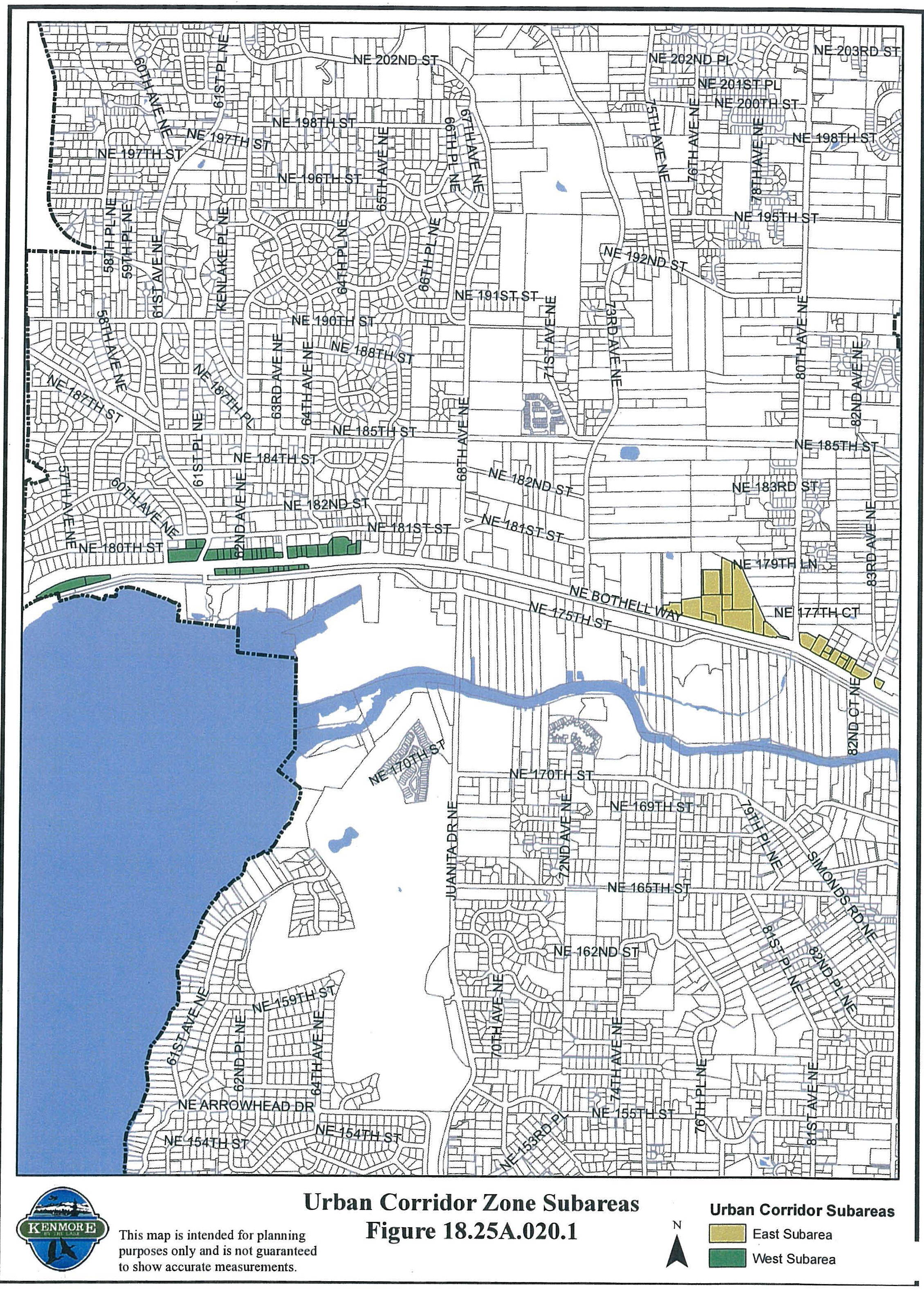
18.25A.020 Subareas.
The urban corridor zone is divided into two subareas: urban corridor west and urban corridor east as depicted in Figure 18.25A.020.1.
[Ord. 14-0391 § 2 (Exh. 1).]
18.25A.030 Use allowances – Urban corridor west subarea.
The following uses listed in Table A are identified as permitted, conditionally permitted, or prohibited uses in the urban corridor west subarea:
|
PERMITTED |
CONDITIONALLY PERMITTED |
PROHIBITED |
|---|---|---|
|
Adult entertainment business1 Ambulatory surgery center Animal kennel/shelter2 Arts, entertainment, indoor Business service, standard Cemetery, columbarium or mausoleum3 Community residential facility Day care Eating and drinking place4 Educational service Funeral home/crematory Health care and social assistance Laboratory5 Manufacturing, light Marijuana business Mobile food service6 Multiple-family dwelling7 Office Park Personal service Recreational facility, indoor8 Religious institution Retail sales9 Standalone parking10 Supportive living facility Temporary lodging |
Arts, entertainment, outdoor11 College/university Fire or police facility Laboratory5 Recreational facility, indoor8 Recreational facility, outdoor13 |
Air transportation service Auction house Automotive sales and service, marine Automotive sales and service, nonmarine Business service, intensive Construction and trade Family child-care home Hospital Manufactured housing community Manufacturing, heavy Marijuana cooperative Recreational facility, outdoor13 Regional land use Resource land use Retail sales, bulk Secure facility Single detached dwelling unit Transportation Utility facility Vehicle or equipment rental Vehicle refueling station Warehousing Wholesale trade |
1 It shall be unlawful for any person to establish an adult entertainment business or to relocate an adult entertainment business within 330 feet, measured from the property line of the parcel or parcels proposed to contain the adult entertainment business to the property line of the parcels containing the uses in this subsection, without regard to intervening structures or objects, of any:
a. Residentially zoned property;
b. Public or private school for general education of any grade K through 12;
c. School bus stop;
d. Licensed day care or licensed preschool facility;
e. Public park;
f. Publicly dedicated trail; provided, however, that the setback distance shall apply only on the south side of the Burke-Gilman Trail, and that there shall be no setback on the north side of that trail due to the separation provided by Highway 522;
g. Sports fields or playgrounds;
h. Recreation or community center;
i. Religious institution;
j. Public library.
It shall be unlawful for any person to establish an adult entertainment business or to relocate an adult entertainment business within 500 feet of another adult entertainment business, measured from the property line of the parcel or parcels containing the adult entertainment business and the proposed adult entertainment business.
2 Provided:
a. No burning of refuse or dead animals is allowed;
b. The portion of the building or structure in which animals are kept or treated shall be soundproofed. All run areas, excluding confinement areas for livestock, shall be surrounded by an eight-foot solid wall and surfaced with concrete or other impervious material;
c. Outdoor runs shall be prohibited on properties adjacent to residential zones; and
d. The provisions of Chapter 18.70 KMC relative to animal keeping shall be met.
3 Limited to indoor columbariums and mausoleums only.
4 Social card games, as defined by this title, are prohibited.
5 Laboratories that must comply with special containment procedures for large quantities of hazardous materials are subject to a conditional use permit.
6 Provided:
a. No permanent fencing, walls, or other structures shall be installed which hinder removal of the structure from the site, unless the structure is permanently permitted.
b. No required parking stall shall be blocked or rendered unusable as a result of the mobile vendor.
c. Safe ingress and egress shall be maintained. Visibility for transportation and pedestrian access shall be maintained.
d. The limited duration of the mobile vendor shall be established as a condition of approval of any applicable permits.
e. A sign permit is required for exterior signage in accordance with the sign code, Chapter 18.42 KMC.
7 North of SR-522, allowed only as part of a mixed use development subject to the conditions of Chapter 18.50 KMC.
8 South of SR-522, indoor recreational facility is a conditional use.
9 South of SR-522, allowed only as part of a mixed use development subject to the conditions of Chapter 18.50 KMC.
10 Standalone surface parking and boat racks shall not be permitted.
11 Outdoor activities shall be at least 50 feet from adjoining residential zones and lighting shall be directed away from adjoining residential zones. Hours of operation may be restricted to ensure compatibility.
12 Reserved.
13 North of SR-522, outdoor recreational facility is a prohibited use. Campgrounds and RV parks shall not be permitted south of SR-522.
[Ord. 19-0481 § 2 (Exh. A); Ord. 16-0426 § 5 (Att. C); Ord. 16-0421 § 2 (Att. A); Ord. 14-0391 § 2 (Exh. 1).]
18.25A.040 Use allowances – Urban corridor east subarea.
The following uses listed in Table B are identified as permitted, conditionally permitted, or prohibited uses in the urban corridor east subarea:
|
PERMITTED |
CONDITIONALLY PERMITTED |
PROHIBITED |
|---|---|---|
|
Adult entertainment business1 Ambulatory surgery center Animal kennel/shelter2 Arts, entertainment, indoor Arts, entertainment, outdoor3 Business service, standard Cemetery, columbarium or mausoleum4 Community residential facility5 Day care Eating and drinking place6 Educational service Funeral home/crematory Health care and social assistance Laboratory7 Manufacturing, light Marijuana business Mobile food service8 Multiple-family dwelling13,14 Office Park Personal service Recreational facility, indoor Recreational facility, outdoor3,9 Religious institution Retail sales Retail sales, bulk5,10 Standalone parking11 Supportive living facility Temporary lodging Vehicle refueling station12 |
College/university Fire or police facility Hospital5 Laboratory7 Regional land use5 Retail sales, bulk5,10 |
Air transportation service Arts, entertainment, outdoor3 Auction house Automotive sales and service, marine Automotive sales and service, nonmarine Business service, intensive Community residential facility5 Construction and trade Family child-care home Hospital5 Manufactured housing community Manufacturing, heavy Marijuana cooperative Recreational facility, outdoor3 Regional land use5 Resource land use Retail sales, bulk5 Secure facility Single detached dwelling unit Standalone parking11 Transportation Utility facility Vehicle or equipment rental Vehicle refueling station12 Warehousing Wholesale trade |
1 It shall be unlawful for any person to establish an adult entertainment business or to relocate an adult entertainment business within 330 feet, measured from the property line of the parcel or parcels proposed to contain the adult entertainment business to the property line of the parcels containing the uses in this subsection, without regard to intervening structures or objects, of any:
a. Residentially zoned property;
b. Public or private school for general education of any grade K through 12;
c. School bus stop;
d. Licensed day care or licensed preschool facility;
e. Public park;
f. Publicly dedicated trail; provided, however, that the setback distance shall apply only on the south side of the Burke-Gilman Trail, and that there shall be no setback on the north side of that trail due to the separation provided by Highway 522;
g. Sports fields or playgrounds;
h. Recreation or community center;
i. Religious institution;
j. Public library.
It shall be unlawful for any person to establish an adult entertainment business or to relocate an adult entertainment business within 500 feet of another adult entertainment business, measured from the property line of the parcel or parcels containing the adult entertainment business and the proposed adult entertainment business.
2 Provided:
a. No burning of refuse or dead animals is allowed;
b. The portion of the building or structure in which animals are kept or treated shall be soundproofed. All run areas, excluding confinement areas for livestock, shall be surrounded by an eight-foot solid wall and surfaced with concrete or other impervious material;
c. Outdoor runs shall be prohibited on properties adjacent to residential zones; and
d. The provisions of Chapter 18.70 KMC relative to animal keeping shall be met.
3 Prohibited east of 80th Avenue NE. West of 80th Avenue NE, outdoor activities shall be at least 50 feet from adjoining residential zones and lighting shall be directed away from adjoining residential zones. Hours of operation may be restricted to ensure compatibility.
4 East of 80th Avenue NE, limited to indoor columbariums and mausoleums only.
5 Prohibited east of 80th Avenue NE.
6 Social card games, as defined by this title, are prohibited.
7 Laboratories that must comply with special containment procedures for large quantities of hazardous materials are subject to a conditional use permit.
8 Provided:
a. No permanent fencing, walls, or other structures shall be installed which hinder removal of the structure from the site, unless the structure is permanently permitted.
b. No required parking stall shall be blocked or rendered unusable as a result of the mobile vendor.
c. Safe ingress and egress shall be maintained. Visibility for transportation and pedestrian access shall be maintained.
d. The limited duration of the mobile vendor shall be established as a condition of approval of any applicable permits.
e. A sign permit is required for exterior signage in accordance with the sign code, Chapter 18.42 KMC.
9 Campgrounds and RV parks shall not be permitted.
10 A conditional use permit is required if the building footprint is greater than 65,000 sq. ft.
11 Prohibited east of 80th Avenue NE. Standalone surface parking lots for vehicles, boats or boat racks shall not exceed 10,000 sq. ft. in size west of 80th Avenue NE.
12 Permitted only within 250 feet of the intersection of 80th Avenue NE and SR-522. Prohibited in other portions of the east subarea.
13 A standalone townhouse development is prohibited.
14 On street frontages, the following conditions apply:
a. A minimum of 80 percent of the structure’s street front facade at street level shall be occupied by nonresidential (e.g., retail, office or service) uses.
b. The required nonresidential uses shall extend at least 30 feet in depth at street level from the street front facade of the structure; provided, that the minimum required depth may be averaged, with no depth less than 15 feet.
Exception: These requirements do not apply to multifamily structures containing 100 percent affordable housing units.
Exception: This section, as amended by Ordinance No. 23-0574, shall not apply to certain real properties located within the area of the transit oriented development (TOD) district overlay as identified in KMC 18.29.020 and Figure 18.29.020.1, and as further identified by the following tax parcel numbers (TPN): TPN 011410-0889, TPN 011410-0881, TPN 011410-0870, TPN 011410-0885, TPN 011410-0865, TPN 011410-0860, and TPN 011410-0855 (collectively, the “parcels”). This section adopted under Ordinance No. 19-0481 shall apply and remain in full force and effect for these parcels. [Ord. 23-0574 § 2 (Exh. A); Ord. 19-0481 § 2 (Exh. A); Ord. 16-0426 § 5 (Att. C); Ord. 16-0421 § 2 (Att. A); Ord. 14-0391 § 2 (Exh. 1).]
18.25A.050 Accessory uses.
Accessory uses, when consistent with the definition in Chapter 18.20 KMC, are allowed as determined by the city manager. [Ord. 14-0391 § 2 (Exh. 1).]
18.25A.060 Zoning standards.
The following zone-specific development standards in Table C apply in the urban corridor zone:
|
STANDARD |
REQUIREMENT |
|---|---|
|
Urban Corridor West Subarea |
48 du/ac |
|
Urban Corridor West Subarea |
72 du/ac1 |
|
Urban Corridor East Subarea |
60 du/ac |
|
Urban Corridor East Subarea |
150 du/ac |
|
Minimum Street Setback |
10 ft.2 |
|
Minimum Interior Setback |
20 ft.3 |
|
Maximum Height: |
|
|
Urban Corridor East Subarea |
85 ft.5,6 |
|
Urban Corridor West Subarea: |
|
|
• south of SR-522 |
35 ft. |
|
• north of SR-522 west of 63rd Ave. NE |
35 ft. |
|
• north of SR-522 east of 63rd Ave. NE |
35 ft.4 |
|
Maximum Impervious Surface: Percentage |
90% |
1 This density may only be achieved through the application of residential density incentives or transfer of density credits in mixed use developments. See Chapter 18.80 KMC.
2 Gas station pump islands shall be placed no closer than 25 feet to street front lines.
3 Required on property lines adjoining residential zones.
4 The maximum height on a site north of SR-522 east of 63rd Avenue NE may be increased up to a maximum of 55 feet if (1) there is no intervening parcel between the site and the NE 181st Street right-of-way, and (2) if the applicant can demonstrate, based on ground elevation data, that a topographic change is adequate to protect views of Lake Washington from uphill lots. The measurement shall be taken as follows: a) determine average existing ground elevation along the centerline of the NE 181st Street right-of-way abutting the site; b) determine average existing ground elevation along an artificial east-west line 60 feet north of and paralleling the SR-522 right-of-way abutting the site; c) subtract the elevation calculated in b) from the elevation calculated in a). If this difference is more than 35 feet, the maximum height for the site may be increased to that difference. In no case, however, shall the maximum allowable height exceed 55 feet.
5 Portions of any property that are within 50 feet of an R-1, R-4, R-6, or MHC zoning district shall have a maximum height of 35 feet within that area to provide a transition in height to the lower intensity uses.
6 Building heights and orientation for proposals within the great blue heron rookery buffer shall be carefully assessed through the required habitat management plan (see Chapter 18.55 KMC, Articles XIII through XV). In particular, potential impacts related to the flyway and shadowing of nest trees shall be evaluated. The city manager may require adjustments to maximum building height and/or building orientation to protect the rookery.
Exception: This section, as amended by Ordinance No. 23-0574, shall not apply to certain real properties located within the area of the transit oriented development (TOD) district overlay as identified in KMC 18.29.020 and Figure 18.29.020.1, and as further identified by the following tax parcel numbers (TPN): TPN 011410-0889, TPN 011410-0881, TPN 011410-0870, TPN 011410-0885, TPN 011410-0865, TPN 011410-0860, and TPN 011410-0855 (collectively, the “parcels”). This section adopted under Ordinance No. 16-0428 shall apply and remain in full force and effect for these parcels. [Ord. 23-0574 § 2 (Exh. A); Ord. 16-0428 § 13 (Att. I); Ord. 14-0391 § 2 (Exh. 1).]
18.25A.070 Additional development standards.
A. Where the urban corridor zone abuts a residential zone, the city manager may require additional landscaping pursuant to Chapter 18.35 KMC, blank wall treatments pursuant to Chapter 18.52 KMC, and/or measures to address building mass and bulk pursuant to KMC 18.52.310 and/or 18.52.330 in order to mitigate impacts of new development on neighboring residential areas.
B. Drive-through service is not permitted in the urban corridor east subarea. In the urban corridor west subarea, drive-through is permitted as an accessory use. Drive-through service shall be oriented to the side and/or rear of the building, and integrated into the exterior wall. Drive-through lanes shall not be located between the street and the main pedestrian access to the buildings. Modifications to these requirements may be reviewed through the site plan or building permit review process when meeting the intent of pedestrian orientation pursuant to Chapter 18.52 KMC, Design Standards.
C. Outdoor storage is prohibited in the urban corridor zone, west subarea, and in the urban corridor zone, east subarea, east of 80th Avenue NE. In the urban corridor zone, east subarea, west of 80th Avenue NE, accessory outdoor storage is limited to a maximum of 50 percent of the site area. [Ord. 23-0574 § 2 (Exh. A); Ord. 16-0428 § 13 (Att. I); Ord. 14-0391 § 2 (Exh. 1).]
18.25A.075 View corridors in the urban corridor zone, west subarea.
A. In the urban corridor west subarea, parcels on the south side of SR-522 shall provide a public view corridor from SR-522 to Lake Washington. The intent of the corridor is to provide an unobstructed view from SR-522 to the lake. A minimum view corridor equivalent to 30 percent of the average east-west dimension of the development proposal site shall be maintained. The location of the view corridor shall be designed to meet the following standards and must be approved by the city manager:
1. The view corridor must be adjacent to one of the two side property lines, whichever will result in the widest view corridor, considering the following in order of priority:
a. Locations of existing view corridors;
b. Existing development or potential development on adjacent properties, given the topography, access and likely location of future improvements;
c. Locations of existing sight-obscuring structures, parking areas or vegetation that are likely to remain in place in the foreseeable future.
2. The view corridor must be in one continuous piece.
3. For land divisions, the view corridor shall be established as part of the land division and shall be located to create the largest view corridor on the subject property.
4. The following shall be permitted within a view corridor:
a. Areas provided for public access, such as public pedestrian walkways, public use areas, or viewing platforms;
b. Parking lots for passenger vehicles and subsurface parking structures; provided, that the parking does not completely obstruct the view of the lake from the public right-of-way;
c. Structures, if the slope of the subject property permits full, unobstructed views of the lake over the structures from the public right-of-way;
d. Vegetation, including required vegetation screening, provided it is designed and of a size that will not obscure the view from the public right-of-way to the lake at the time of planting or upon future growth. Low growing, native vegetation is encouraged. In the event of a conflict between required landscaping and view preservation, view preservation shall take precedence over landscaping requirements;
e. Open fencing that is designed not to obscure the view from the public right-of-way to the lake.
5. The applicant shall execute a covenant or similar legal agreement, in a form acceptable to the city attorney, and record the agreement with the county records and elections division to protect the view corridor. Land survey information shall be provided by the applicant for this purpose in a format approved by the city manager. [Ord. 23-0574 § 2 (Exh. A).]
18.25A.090 Connectivity requirements in the urban corridor zone, east subarea.
The urban corridor zone, east subarea, should remove impediments to pedestrian use of the district and the downtown area by fostering the creation of an extensive network of sidewalks and pedestrian walkways.
Development proposals shall:
A. Provide any direct pedestrian connections between proposed development and transit facilities, or arterials providing transit access in order to minimize walking distances to transit.
B. Comply with the design standards pertaining to pedestrian walkways, as set forth in KMC 18.52.100.
C. Properties abutting water bodies (i.e., wetlands or streams) shall provide a public access trail paralleling the water body from one property line to the next with setbacks that are consistent with the requirements of KMC Title 16 and Chapter 18.55 KMC. The public access trail shall connect to a public right-of-way.
1. Where a development proposal abuts a property with a public access trail segment, the public access segment on the subject property shall connect to abutting property public access segment(s).
2. The public access easement for public access trails shall be documented on the face of the plat or plan and recorded with the King County department of records and elections. Public access easements shall run with the land in perpetuity.
Exception: This section, as amended by Ordinance No. 23-0574, shall not apply to certain real properties located within the area of the transit oriented development (TOD) district overlay as identified in KMC 18.29.020 and Figure 18.29.020.1, and as further identified by the following tax parcel numbers (TPN): TPN 011410-0889, TPN 011410-0881, TPN 011410-0870, TPN 011410-0885, TPN 011410-0865, TPN 011410-0860, and TPN 011410-0855. [Ord. 23-0574 § 2 (Exh. A).]
18.25A.100 Affordable housing requirements in the urban corridor zone, east subarea.
Development in the urban corridor zone, east subarea, containing residential units shall provide affordable housing as described in Chapter 18.77 KMC. [Ord. 23-0574 § 2 (Exh. A).]
18.25A.105 Design requirements.
Development within the urban corridor zone shall comply with the provisions of the design standards, as set forth in Chapter 18.52 KMC. In the event of a conflict between Chapter 18.52 KMC, Design Standards, and urban corridor zone standards, the Kenmore design standards shall prevail. [Ord. 23-0574 § 2 (Exh. A); Ord. 14-0391 § 2 (Exh. 1). Formerly 18.25A.080.]
18.25A.110 Wireless communication facilities.
Use allowances and development regulations for wireless communication facilities are located in Chapter 18.60 KMC. [Ord. 23-0574 § 2 (Exh. A); Ord. 16-0426 § 6 (Att. D). Formerly 18.25A.075.]