


Chapter 22.600
SHORELINE USE AND MODIFICATION DEVELOPMENT STANDARDS
Sections:
22.600.105 Use and modifications matrix.
22.600.120 Barrier structures and other in-stream structures.
22.600.125 Boating facilities.
22.600.130 Commercial development.
22.600.135 Dredging and dredge disposal.
22.600.145 Forest practices/timber harvest.
22.600.150 Industrial development.
22.600.160 Mooring structures and activities.
22.600.165 Recreation and public access.
22.600.170 Residential development.
22.600.175 Shoreline stabilization.
22.600.100 Applicability.
The provisions in this chapter apply to specific common uses and modifications and types of development to the extent they occur within shoreline jurisdiction.
(Ord. 598 (2021) § 4 (Appx. 1), 2021)
22.600.105 Use and modifications matrix.
|
SHORELINE USES and MODIFICATIONS The following permits apply to the specific uses, modifications and development. Individual uses, modifications and development shall comply with the provisions of this program, particularly Section 22.400.110 (Mitigation), and the Kitsap County Comprehensive Plan as of the effective date of this program. |
||||||
|---|---|---|---|---|---|---|
|
Legend: P = Permitted with substantial development permit (SDP) or exempt if exemption criteria in Section 22.500.100(C) are met C = Conditional use permit (CUP) C(A) = Administrative CUP X = Prohibited |
Natural |
Rural Conservancy |
Urban Conservancy |
Shoreline Residential |
High Intensity |
Aquatic |
|
Agriculture |
||||||
|
General1 |
X |
P |
P |
P |
X |
X |
|
Aquaculture |
||||||
|
Commercial Geoduck |
C |
C |
C |
C |
C |
2 |
|
Other Aquaculture |
P3 |
P3 |
P3 |
P3 |
P3 |
2 |
|
Note: An SDP shall not be required for aquaculture development that meets the exemption criteria at Section 22.500.100(C). Supplemental seeding activities are also exempt. |
||||||
|
Barrier Structures (Includes Breakwaters, Jetties, Groins and Weirs) |
||||||
|
General |
X |
C |
C |
C |
C |
2 |
|
Ecological Restoration4 |
P |
P |
P |
P |
P |
2 |
|
Boating Facilities (Including Marinas) |
||||||
|
General |
X |
P |
P |
P |
P |
2 |
|
Marinas |
X |
C |
C |
C |
C |
2 |
|
Commercial |
||||||
|
Water-Oriented |
X |
P |
P |
P |
P |
X5 |
|
Non-Water-Oriented |
X |
X6 |
X6 |
X6 |
X6 |
X6 |
|
Dredging (See Section 22.600.135) |
||||||
|
General |
X |
C |
C |
C |
C |
2 |
|
Dredge Disposal (See Section 22.600.135) |
||||||
|
General |
X |
C |
C |
C |
C |
2 |
|
Ecological Restoration7 |
C |
P |
P |
P |
P |
2 |
|
Fill (See Section 22.600.140) |
||||||
|
Waterward of OHWM |
X |
C |
C |
C |
C |
2 |
|
Upland of OHWM, or Ecological Restoration |
C |
P |
P |
P |
P |
2 |
|
Ecological Restoration |
P |
P |
P |
P |
P |
2 |
|
Flood Hazard Reduction Measures |
||||||
|
General |
C |
C |
C |
C |
C |
C |
|
Forest Practices |
||||||
|
Commercial Forestry |
C |
P |
X |
X |
X |
N/A |
|
Class IV – General |
C |
P |
P |
P |
P |
N/A |
|
Industrial |
||||||
|
Water-Oriented Uses |
X |
X |
C |
C |
P |
X8 |
|
Non-Water-Oriented Uses |
X |
X |
X |
X |
X |
X |
|
Mining |
||||||
|
General |
X |
C9 |
X |
X |
C9 |
X |
|
Mooring Structures and Activities (Includes Piers, Docks, Floats, Ramps and Buoys) |
||||||
|
Single Use |
X10 |
P10 |
P10 |
P10 |
P10 |
2 |
|
Joint or Public Use |
X11 |
P |
P |
P |
P |
2 |
|
Recreation and Public Access |
||||||
|
Nonmotorized, Water-Oriented |
P |
P |
P |
P |
P |
13 |
|
Other Water-Oriented |
C12 |
P |
P |
P |
P |
13 |
|
Non-Water-Oriented |
X |
P14 |
P14 |
P14 |
P14 |
X |
|
Residential |
||||||
|
Single-Family |
C(A) |
P15 |
P15 |
P15 |
P15 |
X |
|
Multifamily, Subdivisions, and Accessory Dwelling Units |
X16 |
C |
C |
P |
P |
X |
|
Restoration and Enhancement |
||||||
|
General |
P |
P |
P |
P |
P |
P |
|
Shoreline Stabilization |
||||||
|
Hard |
C(A) |
C(A) |
C(A) |
C(A) |
C(A) |
18 |
|
Hybrid |
C(A) |
C(A) |
C(A) |
C(A) |
C(A) |
24 |
|
Soft |
P17 |
P17 |
P17 |
P17 |
P17 |
19 |
|
Transportation |
||||||
|
General |
X20 |
C |
C |
P |
P |
P21 |
|
Utilities |
||||||
|
General |
X22 |
P23 |
P23 |
P23 |
P23 |
C |
Footnotes:
1. Does not modify or limit agricultural activities occurring on lands currently in agricultural use.
2. Adjoining upland designation applies; see applicable regulations in Title 17 (Zoning) of the underlying zoning and Section 22.600.110.
3. Floating net pens are prohibited south of Hazel Point on Hood Canal, otherwise a CUP shall be required for floating net pens in all other areas and for aquaculture activities in the natural environment designation where the proposal requires new structures or facilities (see Section 22.600.115).
4. See barrier structures and other in-stream structures (Section 22.600.120) for qualifying ecological restoration.
5. If the use is water-dependent or necessary to support an allowed use in the adjoining upland designation, then may be permitted through an SDP.
6. See commercial development (Section 22.600.130) for allowances with a CUP.
7. See dredging and dredge disposal (Section 22.600.135) for qualifying ecological restoration.
8. If the use is water-dependent or necessary to support an allowed use in the adjoining upland designation, then may be permitted with a CUP.
9. Provided consistent with the Kitsap County Comprehensive Plan mineral resources overlay.
10. Single-use buoys are exempt from substantial development permit in certain environments, in accordance with Sections 22.500.100(C)(2)(b); 22.500.100(C)(3)(f); and 22.600.160(A)(1).
11. If the adjoining upland use is a public park, then up to two buoys allowed.
12. May be permitted through an SDP if consistent with an approved park plan.
13. See recreation and public access (Section 22.600.165) for applicability in the aquatic designation.
14. Non-water-oriented uses shall be subject to shoreline buffer standards (Section 22.400.120).
15. Exempt if single-family residence exemption criteria in Section 22.500.100(C)(3) are met.
16. May be permitted through a CUP for subdivisions.
17. Soft shore shoreline stabilization is exempt from an SDP if exemption criteria in Section 22.500.100(C)(3)(c) are met.
18. Hard or hybrid shoreline stabilization is prohibited in aquatic unless demonstrated necessary, then may be permitted with a CUP (see Section 22.600.175).
19. Soft shoreline stabilization may be permitted with an SDP in the aquatic shoreline environment designation where demonstrated necessary, or through an exemption where criteria are met (see Sections 22.500.100(C) and 22.600.175(D)).
20. If necessary to serve essential transportation corridors or in support of permitted uses and activities that cannot be located outside of applicable buffers, may be permitted through a CUP (see Section 22.600.180).
21. See transportation (Section 22.600.180) for limitations in aquatic designation.
22. If essential utilities in support of permitted uses and activities that cannot be located outside of applicable buffers, may be permitted with a CUP.
23. Utilities associated with an exempt single-family residence and appurtenances exempt also.
24. Refer to hybrid stabilization (Section 22.600.175).
(Ord. 598 (2021) § 4 (Appx. 1), 2021)
22.600.110 Agriculture.
A. Environment Designations Permit Requirements. Except for agricultural uses and lands that exist at the time of the adoption of this program, and thus do not need to apply for a permit, where agriculture is proposed in the following designations the identified permit requirements shall apply:
1. Natural: prohibited.
2. Rural conservancy and urban conservancy: SDP.
3. Shoreline residential: SDP.
4. High intensity: prohibited.
5. Aquatic: prohibited (farming of fin fish, shellfish and management of other aquatic products are subject to the policies and regulations of Section 22.600.115, Aquaculture).
B. Development Standards.
1. New agricultural practices below the standard buffer and above the reduced standard buffer shall require an approved farm management plan in accordance with United States Department of Agriculture standards.
2. Existing Agriculture.
a. This section does not require modification of or limit agricultural activities occurring on agricultural lands as of the effective date of this program.
b. Expansion of agricultural activities on existing agricultural lands shall be encouraged to comply with the vegetation conservation standards identified in Section 22.400.120 to the greatest extent feasible.
3. New Agricultural Activities on Nonagricultural Land.
a. New agricultural activities proposed on land not currently in agricultural use, and any modifications in support of such use, shall comply with the following:
i. The use or modification is consistent with the environment designation in which the land is located; and
ii. The use or modification is located and designed to assure no net loss of ecological functions and in such a way as to not have a significant adverse impact on other shoreline resources and values.
b. A native vegetation buffer, consistent with that of the environment designation in which the use is occurring, shall be permanently maintained between new agricultural activities and the OHWM of the shoreline or wetlands. A fence shall be installed at the outer buffer edge to separate water bodies from livestock pastures.
c. Confined animal feeding operations, retention and storage ponds for feed lot wastes, and stock piles of manure solids shall not be allowed within shoreline jurisdiction, unless shoreline ecological functions are mitigated through an approved farm management plan.
d. Soil conservation measures, including but not limited to erosion control, crop rotation, mulching, strip cropping, contour cultivation, and best management practices, shall be utilized to minimize soil erosion.
e. Aerial spraying of fertilizers, pesticides, or herbicides over water bodies is prohibited.
f. No fertilizers, pesticides or herbicides shall be used in agricultural practices unless the applicant can demonstrate that the application of such substances will not result in the direct runoff of contaminated waters into water bodies or aquifer recharge areas.
g. The applicant may be required to submit a soil study and drainage plan in order to determine that the agricultural practices meet the regulations set forth above.
4. Nonagricultural Activities on Agricultural Land. The use of agricultural land for development that does not meet the definition of agricultural activities, including the conversion of agricultural land to nonagricultural uses, shall be consistent with the environment designation and the general and specific regulations applicable to the proposed use, and shall result in no net loss of ecological functions associated with the shoreline.
(Ord. 598 (2021) § 4 (Appx. 1), 2021)
22.600.115 Aquaculture.
A. Environment Designations Permit Requirements. Where aquaculture is proposed in the following upland designations, the identified permit requirements shall apply. Where proposed in the adjacent aquatic designation, the corresponding upland designation shall be used to determine permit requirements:
1. High intensity, shoreline residential, urban conservancy, rural conservancy, and natural: Except as otherwise stated in this section, an SDP shall be required for new aquaculture activities that meet the definition of substantial development under the Shoreline Management Act and this shoreline master program.
2. Natural: A CUP shall be required where the proposal requires new structure or facilities.
3. Geoduck Aquaculture in All Designations.
a. A CUP shall be required for all new commercial geoduck aquaculture and existing aquaculture being converted to commercial geoduck aquaculture.
b. An SDP shall be required for the planting, growing and harvesting of farm-raised geoducks only if the specific project or practice causes substantial interference with normal public use of the surface waters.
c. Wildstock geoduck harvest associated with the state and tribal co-managed geoduck fishery is not aquaculture. Since a fishery does not constitute development under this program, it is not subject to its regulations.
4. Certain aquaculture developments and supplemental wild stock seeding may be exempt from SDP requirements pursuant to the exemption criteria at Section 22.500.100(C). Such activities shall also comply with all state and federal requirements, including but not limited to Department of Health certification and license, or shellfish import or shellfish transfer permits, where applicable.
B. Application Requirements. In addition to the minimum application requirements in Section 22.500.105(C), aquaculture applications shall include the following information if not already provided in the local, state or federal permit applications. Where requested information is not applicable to a specific proposal, the application shall not be required to include all items listed under this section as long as it is demonstrated why the information does not apply, with concurrence from the department.
1. A site plan, including:
a. The perimeter of the proposed aquaculture operation area;
b. Existing bathymetry depths based on mean lower low water (MLLW datum);
c. Adjacent upland use, vegetation, presence of structures, docks, bulkheads and other modifications;
d. Areas where specific substrate modification will take place or structures will be constructed or installed;
e. Access provisions for marine or vehicle traffic, processing structures or facilities; and
f. Location of storage or processing structures or facilities.
2. A baseline description of existing and seasonal conditions, including best available information. Where applicable to the subject proposal, the following shall be included. Note: Information regarding wind conditions, current flows and flushing rates (subsections (B)(2)(c) through (e) of this section) will generally not be applicable to shellfish aquaculture applications.
a. Water quality;
b. Tidal variations;
c. Prevailing storm wind conditions;
d. Current flows at each tidal cycle;
e. Flushing rates;
f. Littoral drift;
g. Sediment dispersal, including areas of differing substrate composition;
h. Areas of aquatic, intertidal and upland vegetation complexes; a vegetation habitat survey (see Section 22.700.145, Biological and Habitat Surveys) must be conducted according to the most current WDFW eelgrass and macroalgae survey guidelines;
i. Aquatic and benthic organisms present, including forage fish, and spawning and other lifecycle use of, or adjacent to, the site;
j. Probable direct, indirect and cumulative impacts to items (B)(2)(a) through (i) of this section; and
k. Visual assessment, including photo analysis/simulation of the proposed activity demonstrating visual impacts within one thousand five hundred feet of the proposed project site. Where predator exclusion devices are proposed, the assessment shall include an analysis of visual impacts of proposed predator exclusion devices at mean high and mean low tides.
3. An operational plan, which includes the following, when applicable:
a. Species, and quantity to be reared;
b. Source of aquatic product;
c. Implementation methods, including density, schedule, phasing options, time of day, and anticipated lighting and noise levels;
d. Number of employees/workers necessary for the project, including average and peak employment;
e. Methods and location of waste disposal and sanitation facilities;
f. Methods for planting and harvest;
g. Methods for predation control, including types of predator exclusion devices;
h. Food and equipment storage;
i. Anticipated use of any feed, herbicides, antibiotics, vaccines, growth stimulants, antifouling agents, or other chemicals and an assessment of predicted impacts;
j. Methods to address pollutant loading, including biological oxygen demand (BOD);
k. A schedule for water quality monitoring, where required; and
l. Other measures to achieve no net loss of ecological functions consistent with the mitigation sequence described in WAC 173-26-201(2)(e).
4. Other applications and reports, when applicable or requested, to ensure compliance with permit conditions, which may include:
a. An accepted Washington Department of Natural Resources lease application, including a waiver of preference rights to access for navigation from the upland property owner, if applicable;
b. An accepted Washington Department of Ecology National Pollutant Discharge Elimination System (NPDES) permit, if applicable;
c. An accepted Washington Department of Health beach certification number;
d. An accepted WDFW aquatic farm permit, and/or fish transport permit;
e. Water quality studies;
f. Reports on solids accumulation on the bottom resulting from the permitted activity along with its biological effects;
g. Report on growth, productivity, and chemical contamination of shoreline plants and animals within or adjacent to the proposed site;
h. Noise level assessments, including mitigation measures to ensure compliance with Chapter 10.28; and/or
i. Monitoring and adaptive management plan for introduction of aquatic species not previously cultivated in Washington State.
C. Development Standards.
1. General Standards.
a. Aquaculture is dependent on the use of the water area and, when consistent with control of pollution and prevention of damage to the environment, shall be a preferred use.
b. When a shoreline substantial development or conditional use permit is issued for a new aquaculture use or development, that permit shall apply to the initial siting, construction, and planting or stocking of the facility or farm. Authorization to conduct such activities shall be valid for a period of five years with a possible extension per Section 22.500.105(H). After an aquaculture use or development is established under a shoreline permit, continued operation of the use or development, including, but not limited to, maintenance, harvest, replanting, restocking or changing the culture technique shall not require a new or renewed permit unless otherwise provided in the conditions of approval, or if required pursuant to permit revision criteria in WAC 173-27-100 or this program. Changing of the species cultivated shall be subject to applicable standards of this program, including, but not limited to, monitoring and adaptive management in accordance with subsection (C)(1)(g) of this section.
c. Aquaculture shall not be permitted in areas where it would result in a net loss of shoreline ecological functions, or where adverse impacts to critical saltwater and freshwater habitats cannot be mitigated according to the mitigation sequencing requirements of this program (see Section 22.400.110(A)).
d. Aquaculture shall not significantly conflict with navigation and other water-dependent uses.
e. Aquaculture activities proposed within shorelines of statewide significance shall first be subject to the policies for shorelines of statewide significance contained in Chapter 22.300 (General Goals and Policies), and then the policies and regulations contained in this section, in that order of preference.
f. In general, when considering new aquaculture activities, refer to policies at Sections 22.300.125(E) through (K) for siting and design preferences.
g. Project applicants proposing to introduce aquatic species that have not previously been cultivated in Washington State are responsible for pursuing required state and federal approvals relating to the introduction of such species, as determined by applicable state and federal agencies. A plan for monitoring and adaptive management shall also be submitted for county review, unless the operation is conducted in a fully contained system with no water exchange to the shoreline. The county shall provide notice and time to comment for appropriate agencies in accordance with county procedural requirements, and shall circulate the monitoring and adaptive management plan. Upon approval, the plan shall become a condition of project approval.
h. Over-water structures and/or equipment, and any items stored upon such structures such as materials, garbage, tools, or apparatus, shall be designed and maintained to minimize visual impacts. The maximum height for items stored upon such structures shall be limited to three feet, as measured from the surface of the raft or the dock, unless shoreline conditions serve to minimize visual impacts (for example: high bank environments, shorelines without residential development), but in no case shall the height exceed six feet. Height limitations do not apply to materials and apparatus removed from the site on a daily basis. Materials that are not necessary for the immediate and regular operation of the facility shall not be stored waterward of the OHWM.
i. Aquaculture structures and equipment used on tidelands below ordinary high water shall be of sound construction, with the owners’ identifying marks where feasible, and shall be so maintained. Abandoned or unsafe structures and/or equipment shall be promptly removed or repaired by the owner.
j. No processing of any aquaculture product, except for the sorting and culling of the cultured organism and the washing or removal of surface materials or organisms after harvest, shall occur in or over the water unless specifically approved by permit. All other processing and related facilities shall be located on land and shall be subject to the regulations for commercial development (Section 22.600.130) and industrial development (Section 22.600.150), in addition to the provisions of this section.
k. No garbage, wastes or debris shall be allowed to accumulate at the site of any aquaculture operation, except for in proper receptacles.
l. All floating and submerged aquaculture structures and facilities in navigable waters shall be marked in accordance with U.S. Coast Guard requirements.
m. The rights of treaty tribes to aquatic resources within their usual and accustomed areas are addressed through direct coordination between the applicant/proponent and the affected tribe(s). Kitsap County will notify affected tribes of new shoreline permit applications utilizing the applicable notification process in Title 21 (Land Use and Development Procedures).
n. In order to avoid or limit the ecological and aesthetic impacts from aquaculture siting and operations, the following shall apply:
i. Predator exclusion devices shall be firmly attached or secured so as not to become dislodged.
ii. Predator exclusion devices shall blend with the natural environment.
iii. Aquaculture operators shall routinely inspect and maintain predator exclusion devices.
iv. Predator exclusion devices such as rubber bands, small nets, and area netting can be dislodged and pose a hazard to birds, marine mammals, and other wildlife and domestic animals, and thus are subject to Kitsap County public nuisance regulations (Chapter 9.56).
v. Predator exclusion devices shall be removed as soon as they are no longer needed to perform protective functions.
vi. Predator exclusion methods shall not be designed to intentionally kill or injure birds or mammals. Predator exclusion methods shall comply with federal and state regulations as determined by applicable federal and state agencies.
vii. When determined necessary to minimize aesthetic and habitat impacts of large-scale projects, the county may require a phased approach to operation. This includes planting and harvesting areas on a rotational basis within the same tideland parcel.
o. Where aquaculture occurs on state-owned aquatic lands, the project proponent shall contact and adhere to Washington Department of Natural Resources requirements.
2. Additional Standards for Commercial Geoduck Aquaculture.
a. In addition to the general development standards above, commercial geoduck aquaculture shall only be allowed where sediments, topography, land and water access support geoduck aquaculture operations without significant clearing or grading.
b. All permits shall take into account that commercial geoduck operators have the right to harvest geoduck once planted.
c. All subsequent cycles of planting and harvest shall not require a new CUP, subject to WAC 173-27-100.
d. A single CUP may be submitted for multiple sites within an inlet, bay or other defined feature, provided the sites are all under control of the same applicant and within the program’s jurisdiction.
e. Commercial geoduck aquaculture workers shall be allowed to accomplish on-site work during low tides, which may occur at night or on weekends. Where such activities are necessary, noise and light impacts to nearby residents shall be mitigated to the greatest extent practicable.
3. Additional Standards for Net Pens. Fish net pens and rafts shall meet the following criteria:
a. Fish net pens shall meet, at a minimum, state-approved administrative guidelines for the management of net pen cultures. In the event there is a conflict in requirements, the more restrictive shall prevail.
b. Alternative facilities and technologies that reduce ecological and aesthetic impacts shall be preferred to traditional floating net pens.
c. Anchors that minimize disturbance to substrate, such as helical anchors, shall be employed.
d. Net pen facilities shall be located no closer than one thousand five hundred feet from the OHWM, unless a specific lesser distance is determined to be appropriate based upon a visual impact analysis or due to potential impacts to navigational lines.
e. Net cleaning activities shall be conducted on a frequent enough basis so as not to violate state water quality standards.
f. In the event of a significant fish kill at the site of the net pen facility, the facility operator shall submit a timely report to the Kitsap public health district and the Kitsap County department of community development stating the cause of death and shall detail remedial action(s) to be implemented to prevent reoccurrence.
g. Floating net pens shall be prohibited in Kitsap County’s Hood Canal jurisdictional area south of the east-west line between Hazel Point (Jefferson County) and the corresponding easterly shoreline in Kitsap County. (Citation: Recommended Interim Siting Guidelines for the Management of Salmon Net Pen Culture in Puget Sound, p. 7.)
h. New or expanded nonnative marine finfish aquaculture is prohibited.
(Ord. 598 (2021) § 4 (Appx. 1), 2021)
22.600.120 Barrier structures and other in-stream structures.
A. Environment Designations Permit Requirements. Where barrier structures and other in-stream structures are proposed in the following upland designations, the following permit requirements shall apply. Where proposed in the adjacent aquatic designation, the corresponding upland designation shall be used to determine permit requirements.
1. Natural: prohibited, except as otherwise stated in this section.
2. High intensity, shoreline residential, urban conservancy, rural conservancy: CUP, except as otherwise stated in this section.
3. All designations: An SDP shall be required for barrier structures and other in-stream structures that have ecological restoration as the primary purpose.
B. Application Requirements.
1. In addition to the general permit requirements, applications for breakwaters, jetties and groins shall include the following information:
a. Reason for the project;
b. Type of construction;
c. Method of construction;
d. Direction of net long-shore drift;
e. Location of the barrier structure; and
f. Notification of affected property owners, to include at minimum all property owners downdrift of the project in the drift cell, unless reviewed and approved otherwise by the county.
2. In addition to the general permit requirements, applications for weirs and other in-stream structures shall contain, at a minimum, the following:
a. Hydrogeological report (see Section 22.700.125), prepared by a licensed professional engineer, which sufficiently describes the project’s effects on streamway hydraulics, including potential for redirection of the normal flow of the affected stream.
b. Habitat surveys, prepared by a professional biologist consistent with Section 22.700.145, which sufficiently describes the project’s effects on fisheries and wildlife resources.
c. Provision for erosion control, and protection of water quality and fishery and wildlife resources during construction.
d. Long-term management plans, which describe, in sufficient detail, provisions for protection of in-stream resources during construction and operation. The plan shall include a means for monitoring success.
C. Development Standards.
1. When located waterward of the OHWM, barrier structures and other in-stream structures shall be allowed only where necessary to support:
a. Water-dependent uses.
b. Public access.
c. Public facilities or utilities.
d. Existing or restored natural features, with special emphasis on protecting and restoring priority habitats and species, but only where part of an approved restoration plan.
2. Structures shall be designed to protect critical areas, shoreline processes and ecological functions, fish and wildlife passage, natural character/scenery, and cultural resources, and shall provide for mitigation according to the sequence defined in Sections 22.300.100 (Critical areas and ecological protection) and 22.400.110 (Mitigation).
3. Structures shall be the minimum size necessary to achieve the intended purpose.
4. Floating breakwaters shall be utilized instead of solid fill breakwaters, except where proven infeasible.
5. Consideration shall be given to avoiding or minimizing land use conflicts to properties adjacent to the proposed site, whether upstream/updrift or downstream/downdrift.
(Ord. 598 (2021) § 4 (Appx. 1), 2021)
22.600.125 Boating facilities.
A. Environment Designations Permit Requirements. Where boating facilities are proposed in the following upland designations, the identified permit requirements shall apply. Where proposed in the adjacent aquatic designation, the corresponding upland designation shall be used to determine permit requirements:
1. Natural: prohibited.
2. Rural conservancy, urban conservancy, shoreline residential and high intensity:
a. SDP for boating facilities designed for five to nine vessels;
b. CUP for marinas (ten or more vessels) and buoy fields for ten or more vessels.
B. Application Requirements. In addition to the general permit requirements, the applicant shall be required to submit the following information:
1. A study of water quality, water circulation and flushing;
2. A survey of littoral drift and shoreform processes;
3. A benthic and habitat study;
4. A petroleum handling and storage management plan;
5. An emergency management plan, to include fire protection and hazard response;
6. A visual impact assessment;
7. Waste and sewage disposal plan;
8. Speed limits;
9. Noise levels;
10. Lighting and signage;
11. Size, scale, and building materials;
12. Public or private use;
13. Parking and circulation;
14. Distance to the nearest boating facility.
C. Development Standards.
1. General Regulations.
a. All boating facilities must conform to the requirements for mooring structures (Section 22.600.160).
b. Dredging for boating facilities shall conform to the requirements for dredging and dredge disposal (Section 22.600.135).
c. Boating facilities and their associated and accessory uses shall result in no net loss of shoreline ecological functions.
d. Boating facilities shall be located, designed, and maintained to be compatible with abutting land uses and the prevailing community character to the greatest extent feasible. Aesthetic impacts must be avoided, or mitigated where avoidance is not feasible.
e. Boating facilities must meet applicable federal and state health, safety, and welfare requirements. This shall include, but not be limited to, the Kitsap County board of health ordinance (Ordinance 2008A-01 for on-site sewage requirements), and the Bremerton-Kitsap board of health ordinance (Ordinance 1999-13 for marina sewage regulations). In addition, notice of permit application shall be provided to the Washington State Department of Health in order to ensure consistency with state health regulations for shellfish harvest.
f. Boating facilities shall protect the rights of navigation.
g. Boating facilities shall avoid impacts to littoral drift. Where impacts cannot be avoided, mitigation shall be required.
h. All non-water-dependent structures shall be located landward of the OHWM.
2. Marinas.
a. In evaluating an application for a marina, consideration shall be given to water quality, water circulation and flushing, aquatic life, petroleum handling and storage, fire codes, public access and compatibility with other uses.
b. New marinas shall incorporate public access into their master plans pursuant to WAC 173-26-221(4). Examples of public access may include pocket beaches, fishing piers, viewing platforms and transient moorage slips.
c. Accessory parking, transportation facilities, and commercial development shall meet the requirements of Sections 22.600.180 and 22.600.130, respectively.
d. Marinas shall provide an operational plan. At a minimum, the operational plan shall address all of the following:
i. Adequate facilities and operational procedures for fuel handling and storage in order to prevent accidental spillage.
ii. Facilities, equipment and established procedures for the containment, recovery, and mitigation of spilled sewage, petroleum and other hazardous materials.
iii. Signs concerning the following matters where they are readily visible to all marina users:
(A) Regulations pertaining to handling and disposal of waste, sewage, or other toxic materials;
(B) Regulations prohibiting the disposal of fish or shellfish wastes, scrapfish, viscera or unused bait in or near the marina;
(C) Location of all public access facilities and pump-out devices.
iv. Garbage or litter receptacles, including provisions for recycling waste, shall be provided and maintained by the marina operator at several locations convenient to users.
e. Additional standards for marinas.
i. The dock facilities shall be equipped with adequate lifesaving equipment such as life rings, hooks and ropes.
ii. Adequate fire protection shall be required pursuant to the Washington State Uniform Fire Code.
iii. Swimming shall be prohibited within marina facilities unless the swimming area is adequately separated and protected.
iv. If dredging at marina entrances changes the littoral drift processes or adversely affects adjacent shores, the marina operator shall be required to replenish these shores periodically with the appropriate quantity and quality of aggregate, subject to applicable permits and with written approval of the director or designee.
v. Marina facilities permitted under this program shall provide upland restrooms available twenty-four hours a day for use by any patron of the marina facility. At a minimum, the facilities shall include one urinal, one toilet, and one washbasin for men and two toilets and two washbasins for women. The need for additional facilities shall be determined based on the number of slips, percentage of live-aboard moorages, and the number of transient moorage slips within the marina.
vi. All pipes, plumbing, wires and cables at a marina site shall be placed at or below ground and dock levels.
vii. Marinas are permitted to moor live-aboard vessels provided the marina meets the following conditions:
(A) The slips assigned to live-aboards are designed and constructed to handle the anticipated moorage loads of live-aboard vessels;
(B) Sewer hook-ups for live-aboard vessels or upland bathroom facilities to adequately accommodate the number of live-aboards within the facility;
(C) No more than ten percent of the surface area of the marina or ten percent of the slips, whichever is less, is devoted to live-aboard vessels;
(D) In addition to required marina parking, two parking stalls are to be provided for each live-aboard vessel;
(E) If pets are to be allowed, a pet exercise area shall be provided. Marina operators are encouraged to provide such pet exercise areas for pets of live-aboard residences and transient boaters; and
(F) Marina operators execute a lease, contract or deed which establishes permission to use a particular slip for a stated period of time and which establishes conditions for use of the slip such as adherence to marina best management practices, and including the requirement that all boats meet applicable state or federal water quality and sanitation requirements.
(Ord. 598 (2021) § 4 (Appx. 1), 2021)
22.600.130 Commercial development.
A. Environment Designations Permit Requirements. Where commercial development is proposed in the following upland or aquatic designations, the identified permit requirements shall apply:
1. Natural: prohibited.
2. Urban conservancy, rural conservancy, shoreline residential and high intensity:
a. SDP for water-oriented commercial activities;
b. Prohibited for non-water-oriented uses, except CUP for uses described in subsection (B)(8) of this section.
3. Aquatic: prohibited, unless the activity is water-dependent or a necessary appurtenance to a use allowed in the adjoining upland designation, then a CUP.
B. Development Standards.
1. Commercial development shall result in no net loss of shoreline ecological functions or have significant adverse impact to other shoreline uses, resources and values provided for in RCW 90.58.020, such as navigation, recreation and public access.
2. Commercial developments shall be permitted on the shoreline in descending order of preference. The applicant shall demonstrate that a more preferred use is not feasible when proposing a less preferred use.
a. Water-dependent uses;
b. Water-related uses;
c. Water-enjoyment uses;
d. Non-water-oriented uses that include substantial opportunities for public access and subject to a CUP.
3. Commercial development shall not significantly impact views from upland properties, public roadways, or from the water.
4. The design and scale of a commercial development shall be compatible with the shoreline environment. The following criteria will be used to assess compatibility:
a. Building materials.
b. Site coverage.
c. Height.
d. Density.
e. Lighting, signage, and landscaping.
f. Public access.
g. Visual assessment.
5. The county shall consider public access and ecological restoration as potential mitigation of impacts to shoreline resources and values for all water-related or water-dependent commercial development, unless such improvements are demonstrated to be infeasible or inappropriate. Public access shall be provided consistent with Section 22.400.145. In-kind mitigation shall be determined infeasible prior to utilizing out-of-kind mitigation.
6. Non-water-dependent commercial uses shall not be allowed over water except in existing structures or in the limited instances where they are auxiliary to and necessary in support of water-dependent uses.
7. Parking shall be located upland of the commercial use and designed to minimize adverse visual impacts to the shoreline. Over-water parking is prohibited.
8. Non-water-oriented commercial uses are prohibited unless:
a. The use is on land designated commercial by the Kitsap County Comprehensive Plan and existing on the effective date of this program;
b. The use is on land designated commercial by the Kitsap County Comprehensive Plan and is physically separated from the shoreline by another property or public right-of-way;
c. The use is part of a mixed-use project that includes water-dependent uses and provides a significant public benefit with respect to the Act’s objectives, such as providing ecological restoration and public access. Water-dependent components of the project and ecological restoration and access shall be improved prior to occupancy;
d. The use is on a site where navigability is severely limited and the use would provide a significant public benefit with respect to the Act’s objectives, such as providing public access and ecological restoration.
Non-water-oriented commercial uses meeting these criteria must obtain a CUP.
C. Redevelopment.
1. When commercial redevelopment involves relocating or expanding the existing structure, shoreline restoration or mitigation shall be a condition of approval (see Chapter 22.800, Appendix B). Restoration may include, but is not limited to:
a. Moving the structure away from the shoreline;
b. Removing any shoreline armoring or replacing hard with soft armoring;
c. Riparian vegetation restoration, including removing invasive and planting natives;
d. Stormwater retrofits to implement low impact development.
2. When commercial redevelopment involves relocating or expanding the structure, public access shall be a condition of approval, unless infeasible due to health or safety issues. Public access may include, but is not limited to:
a. Maintaining current public access, if existing;
b. Connecting a trail to existing public access on adjacent property;
c. Providing for visual access to the shoreline.
(Ord. 598 (2021) § 4 (Appx. 1), 2021)
22.600.135 Dredging and dredge disposal.
A. Environment Designations Permit Requirements. Where dredging is proposed in the following upland designations, the identified permit requirements shall apply. Where proposed in the adjacent aquatic designation, the corresponding upland designation shall be used to determine permit requirements.
1. Natural: prohibited, unless for purposes of ecological restoration (as defined in this section), then with a CUP.
2. High intensity, shoreline residential, urban conservancy and rural conservancy: CUP, unless for purposes of ecological restoration (as defined in this section), then with an SDP.
3. All designations: Dredging waterward of the OHWM for the primary purpose of obtaining fill material shall not be permitted, except as allowed under subsection (C)(5) of this section.
B. Application Requirements. In addition to the general permit requirements, applications for dredging shall include the following information:
1. An analysis of materials to be dredged, including a habitat survey (Section 22.700.145) and sediment analysis;
2. Time of dredging;
3. Method of dredging and disposal, including a description of water quality best management practices;
4. Location and stability of bedlands adjacent to proposed dredging area;
5. Location, size, capacity and physical characteristics of spoils disposal area;
6. Quantity of material to be removed;
7. An explanation of why the dredging is necessary.
C. Development Standards.
1. Dredging and dredge material disposal shall only be allowed when the purpose is consistent with those listed in WAC 173-26-231(3)(f), and conducted in a manner which avoids and minimizes significant ecological impacts. Impacts which cannot be avoided and minimized shall be mitigated in a manner that assures no net loss of shoreline ecological functions.
2. Dredging for the purpose of establishing, expanding, relocating or reconfiguring navigation channels and basins shall be allowed when necessary for assuring safe and efficient accommodation of existing navigational uses and then only when significant ecological impacts are minimized and when mitigation is provided.
3. Dredging for the purpose of ecological restoration may be allowed when the project is primarily serving to restore degraded ecological functions or ecosystem-wide processes.
4. Maintenance dredging of established navigation channels and basins shall be restricted to maintaining previously dredged and/or existing authorized location, depth, and width. Such activities shall be exempt from an SDP or CUP when compliant with the criteria for normal maintenance or repair (Section 22.500.100(C)(3)(b)).
5. Dredging waterward of the OHWM for the primary purpose of obtaining fill material shall not be allowed, except when the material is necessary for a project to restore ecological functions waterward of the OHWM. Such project shall either be associated with a Model Toxics Control Act (MTCA) or Comprehensive Environmental Response, Compensation and Liability Act (CERCLA) habitat restoration project, or, if approved through a CUP, a significant habitat enhancement project.
6. Deposition of dredge material below ordinary high water shall be allowed only at those Puget Sound dredge disposal sites approved by the Dredged Material Management Program (DMMP) representing the U.S. Army Corps of Engineers, U.S. Environmental Protection Agency, Washington Department of Ecology, and Washington Department of Natural Resources.
7. Disposal of dredge material on shorelands or wetlands within a river’s or stream’s channel migration zone shall not occur, except as authorized by CUP as a part of a shoreline restoration project.
8. Disposal of contaminated dredge materials, not suitable for open water disposal, and otherwise regulated by Section 404 of the Federal Clean Water Act, shall occur only at permitted solid waste or dangerous waste disposal facilities.
(Ord. 598 (2021) § 4 (Appx. 1), 2021)
22.600.140 Fill.
A. Environment Designations Permit Requirements. Where fill is proposed in the following upland designations, the identified permit requirements shall apply. Where proposed in the adjacent aquatic designation, the corresponding upland designation shall be used to determine permit requirements.
1. Natural: prohibited, except for restoration purposes as noted below.
2. High intensity, shoreline residential, urban conservancy, rural conservancy:
a. CUP for fill waterward of the OHWM for any use except ecological restoration.
b. SDP for fill landward of the OHWM.
3. All designations: SDP if for ecological restoration where restoration is the primary purpose for the activity.
4. All designations: fill quantity in excess of one hundred fifty cubic yards shall also require a site development activity permit pursuant to Title 12. In addition, any amount of fill activity on slopes steeper than thirty percent, or within the mandatory setback of a steep slope, wetland, stream, lake or Puget Sound, may require a SDAP.
B. Application Requirements. In addition to general permit requirements, applications for fill shall include, but not be limited to, the following information:
1. Physical, chemical, and biological character of fill materials;
2. Source of fill material;
3. Method of placement and compaction;
4. Type of proposed surfacing and stormwater control devices;
5. Method of perimeter erosion control;
6. Proposed use of fill area;
7. Location of fill relative to natural and/or existing drainage patterns.
C. Development Standards.
1. Fill materials shall be sand, gravel, soil, rock or similar material. Use of polluted dredge spoils or other solid or dangerous wastes as defined by the Kitsap public health district is prohibited.
2. Fill within shoreline jurisdiction shall be avoided to the extent feasible. Where necessary, fill in shoreline jurisdiction shall be located, designed, and constructed to protect shoreline ecological functions and ecosystem-wide processes, including channel migration.
3. Erosion control measures shall be implemented pursuant to Title 12 (Stormwater Drainage).
4. Fill shall be designed and reviewed for avoidance of water quality impacts in accordance with local, state and federal regulations.
5. Fill shall only be allowed for:
a. Water-dependent uses;
b. Public access;
c. Cleanup and disposal of contaminated sediments as part of an interagency environmental cleanup plan;
d. Mitigation action;
e. Environmental restoration;
f. Beach nourishment or enhancement projects;
g. The expansion or alteration of existing transportation facilities of statewide importance located along the shoreline, and only upon demonstration that alternatives to fill are not feasible.
6. Fill shall not be used to create land to serve residential development.
7. Fill shall not be used to create land to serve non-water-dependent commercial development.
8. If archaeological resources are uncovered during excavation, developers and property owners must immediately stop work and notify Kitsap County, the Department of Archaeology and Historic Preservation, and affected Indian tribes. Permits may be conditioned after review by a professional archaeologist, pursuant to MOU KC-442-07.
(Ord. 598 (2021) § 4 (Appx. 1), 2021)
22.600.145 Forest practices/timber harvest.
A. Environment Designations Permit Requirements. Forest practices conducted under a forest practices permit (Class I, II, III and IV special) from the Washington Department of Natural Resources shall not be regulated by this program and shall not require a local shoreline permit. However, forest practice conversions and other Class IV general forest practices where there is a likelihood of conversion to nonforest uses, and timber harvest within shorelines of statewide significance, shall be regulated by this program. A forest practice that only involves timber harvesting accompanied by replanting is not a development under the Act and does not require a shoreline substantial development permit or shoreline exemption. However, a forest practice that includes activities other than timber cutting, such as new or reopened rights-of-way, grading, culvert installation, or stream crossings, or similar development activities may be considered development. Therefore these activities will require a substantial development permit per WAC 222-50-020. Where such forest practices are proposed in the following designations, the identified permit requirements shall apply:
1. Natural: CUP.
2. Rural conservancy: SDP.
3. Urban conservancy, shoreline residential, high intensity:
a. Prohibited for commercial forestry;
b. SDP for Class IV general permit.
4. All designations: CUP for exceptions to shorelines of statewide significance standards in subsection (C)(4) of this section.
B. Application Requirements. In addition to the general permit requirements of this program, a Kitsap County timber harvest permit (Class IV general, Class III conversion option harvest plan, and timber harvest within shorelines of statewide significance) shall be required. This includes all other application requirements as outlined in Chapter 18.16 (Timber Harvest).
C. Development Standards.
1. Forest practices within shoreline jurisdiction shall comply with the requirements of the Forest Practices Act (Chapter 76.09 RCW) and the Forest and Fish Report (United States Fish and Wildlife Service et al., 1999). The following standards shall apply to those activities subject to this program, including forest practices conducted under a Class IV general forest practice permit or Class III forest practices conversion option harvest plan, and timber harvest activities conducted within shorelines of statewide significance.
2. Timber harvest permit activity shall assure no net loss of shoreline ecological functions and shall maintain ecological quality of the watershed’s hydrologic system.
3. Timber harvest permit activity in all shoreline areas shall comply with the policies and regulations outlined in this program, Chapter 18.16 (Timber Harvest) and Title 12 (Stormwater Drainage) for silt and erosion control.
4. With respect to timber situated within the shoreline jurisdiction for shorelines of statewide significance, only selective commercial timber cutting shall be allowed; provided, that no more than thirty percent of the merchantable trees may be harvested in any ten-year period of time; further provided, that:
a. Other timber harvesting methods may be permitted in those limited instances where the topography, soil conditions or silviculture practices necessary for regeneration render selective logging ecologically detrimental; and
b. Clear cutting may occur when timber harvest is solely incidental to the preparation of land for other uses authorized by this chapter.
5. Exceptions to the standards provided in RCW 90.58.150 as stated in subsection (C)(4) of this section shall require a CUP.
6. Failure to apply for a local timber harvest permit, when required, will result in a six-year moratorium on any subsequent development proposals on the subject parcel.
7. When timberland is to be converted to another use, such conversion shall be clearly indicated on the forest practices application. Such failure to declare intent to convert on the application shall provide grounds for the denial of subsequent development proposals for a period of six years from the date of the forest practices application approval (RCW 76.09.060(3)(d)).
8. Timber harvest activities subject to this program shall not be permitted until local plat approval or other applicable land use authorization has been given, and any required shoreline permits have been issued for the land division(s) or intended use(s) where applicable. Class III conversion option harvest plans shall be exempt from this provision.
9. Hazard or View Tree Removal. Where a threat to human life or property is demonstrated, or where view thinning is allowed in accordance with the vegetation conservation buffer standards in Section 22.400.120, the department may allow removal of hazard or view trees within shoreline jurisdiction. Requests for tree removal shall be reviewed by the department in accordance with the following criteria:
a. For hazard trees, tree removal shall be the minimum necessary to balance protection of the critical area or shoreline buffer with protection of life and property. For view trees, tree removal shall be the minimum necessary in accordance with the vegetation conservation buffer standards of Section 22.400.120;
b. The critical area or shoreline buffer shall be replanted as determined by the department and the property owner. Except where determined otherwise, a replanting ratio of three-to-one (planted to removed) shall be a standard requirement;
c. The department shall coordinate with the property owner and WDFW as determined necessary to assure habitat protection. Habitat needs may require leaving the fallen tree within the buffer area or leaving a high stump for wildlife habitat;
d. The department may require the applicant to consult with a professional forester or a certified arborist prior to tree removal;
e. The department may require a site visit to review the proposal, subject to applicable fee requirements in the Kitsap County fee schedule.
(Ord. 598 (2021) § 4 (Appx. 1), 2021)
22.600.150 Industrial development.
A. Environment Designations Permit Requirements. Where industrial development is proposed in the following designations, the identified permit requirements shall apply:
1. Natural and rural conservancy: prohibited.
2. Urban conservancy and shoreline residential: CUP for water-oriented industries. Non-water-oriented industrial development shall be prohibited.
3. High intensity: SDP for water-oriented industries. Non-water-oriented industrial development shall be prohibited, except as specified in subsection (B) of this section.
4. Aquatic: prohibited, unless water-dependent or allowed in the adjoining upland designation, then a CUP.
B. Development Standards.
1. When allowed, industrial development shall be located, designed and constructed in a manner that assures no net loss of shoreline ecological functions, resources and values.
2. Water-dependent, water-related, and non-water-oriented industrial uses are permitted where allowed by zoning and this program. The following preferential order shall be considered by the county when evaluating SMP amendments and determining compliance of shoreline permits:
a. The industrial use is water-dependent, consistent with the Act and this program. The county may require an applicant to provide documentation about the characteristics of the development to confirm the proposal’s water-dependent nature.
b. The industrial use is water-related, consistent with the Act and this program. The county may require an applicant to provide documentation about the characteristics of the development to confirm the proposal’s water-related nature.
c. The industrial use is non-water-oriented and consistent with the exceptions and conditions in subsection (B)(3) of this section.
3. Non-water-oriented industrial development shall be prohibited in shoreline jurisdiction except when:
a. The use is part of a mixed-use project that includes water-dependent uses and provides a significant public benefit with respect to the Act’s objectives such as providing ecological restoration and public access. Any such public access shall be improved prior to occupancy;
b. Navigability is severely limited at the proposed site; and the industrial use provides a significant public benefit with respect to the Act’s objectives, such as providing public access and ecological restoration;
c. The area is designated for industrial use by the Kitsap County Comprehensive Plan and the site is physically separated from the shoreline by another property or public right-of-way.
4. Industrial development must consider incorporating public access as mitigation for impacts to shoreline resources and values unless public access cannot be provided in a manner that does not result in significant interference with operations or hazards to life or property.
5. Where industrial use is proposed for location on land in public ownership, public access shall be required.
6. Industrial development and redevelopment shall locate, when feasible, where environmental cleanup and restoration of the shoreline area can be incorporated.
7. Where industrial uses are allowed, Chapter 17.410 (Allowed Uses) shall apply to new or expanded industrial development.
8. Buffers shall not be used for storage of industrial equipment or materials, nor for waste disposal, but may be used for outdoor recreation if consistent with public access and other provisions of this program.
9. Applications for water-oriented facilities for processing, manufacturing, and storage of natural resource products, including log storage, shall include provisions which address:
a. Navigation;
b. No net loss of shoreline ecological functions;
c. Impacts to public access;
d. Aesthetics.
10. Boat yards and similar ship-building facilities shall comply with the mandatory best management practices and other provisions of the boat yard general permit issued through Ecology (NPDES General Permit No. WAG 030000) as now or hereafter amended.
(Ord. 598 (2021) § 4 (Appx. 1), 2021)
22.600.155 Mining.
A. Environment Designations Permit Requirements. Where mining is proposed in the following designations, the identified permit requirements shall apply:
1. Natural: prohibited.
2. Rural conservancy: CUP.
3. Urban conservancy and shoreline residential: prohibited.
4. High intensity: CUP.
5. Aquatic: prohibited.
B. Development Standards.
1. Mining and associated activities shall only be allowed when all of the following criteria have been met:
a. The location, design and conduct are consistent with the environment designation and with the Kitsap County mineral resource overlay;
b. Demonstrated consistency with critical areas regulations;
c. The activity is dependent on a shoreline location;
d. The activity demonstrates no net loss of shoreline ecological functions through avoidance, minimization and mitigation of adverse impacts during the course of mining and reclamation.
2. All of the provisions and requirements for mining in Chapter 78.44 RCW (Surface Mining), as now or hereafter amended, shall be met.
3. Any proposed subsequent use of mined property shall be consistent with the provisions of the environment designation in which the property is located.
4. Reclamation of disturbed shoreline areas shall be required to provide appropriate ecological functions consistent with the setting.
5. Mining proposals shall give consideration to activities that result in the creation, restoration, or enhancement of habitat for priority species.
6. Mining shall be prohibited waterward of the OHWM and within a channel migration zone.
7. The deposit of overburden within shorelines constitutes fill and shall be subject to the provisions of this program.
(Ord. 598 (2021) § 4 (Appx. 1), 2021)
22.600.160 Mooring structures and activities.
A. Environment Designations Permit Requirements. When mooring structures are proposed in the aquatic designation and are adjacent to the following upland designations, the identified permit requirements shall apply:
1. Natural:
a. Prohibited for single use;
b. Prohibited for joint or public use, unless the adjoining upland is a public park, then up to two mooring buoys may be permitted with an SDP.
2. Rural conservancy, urban conservancy, shoreline residential, and high intensity: SDP.
B. Application Requirements. In addition to the general permit requirements, proposals for mooring structures shall include the following:
1. A staff consultation meeting with the department, state and federal agencies (where applicable), and tribes affected by proposals within their usual and accustomed grounds and stations shall be required prior to application for new piers and docks, pursuant to Chapter 22.500 (Permit Provisions, Review and Enforcement);
2. Description of the proposed structure, including size, location, design, and any other modification required by the project;
3. Ownership of tidelands, shorelands, and/or bedlands;
4. Proposed location of mooring structures relative to property lines and OHWM;
5. Location, width, height, and length of mooring structures on adjacent properties;
6. If for residential moorage, demonstration that existing facilities, including public moorage within ten driving miles of the applicant’s parcel, are not adequate or feasible to accommodate the proposed moorage;
7. Demonstration that alternative types of moorage, including buoys, are not adequate or feasible;
8. For residential docks, written confirmation from each adjoining landowner indicating whether or not a joint-use mooring structure agreement will be entered into; and
9. Habitat surveys as described in Section 22.700.145 shall be required for mooring structures, with the exception of buoys, and shall be conducted according to WDFW, Washington Department of Natural Resources, and the U.S. Army Corps of Engineers parameters, where applicable.
C. Development Standards.
1. General Development Standards.
a. New mooring structures shall be allowed only for water-dependent uses or public access. As used here, a dock associated with a single-family residence is a water-dependent use and may be permitted; provided, that it is designed and intended as a facility for access to watercraft and otherwise complies with the provisions of the Act and this program.
b. Water-related and water-enjoyment uses may be allowed as part of mixed-use development on over-water structures where they are clearly auxiliary to and in support of water-dependent uses, provided the minimum size requirement needed to meet the water-dependent use is not violated.
c. Mooring structures shall follow all applicable state and federal requirements for building standards, materials, installation timing, and surveys.
d. Mooring structures shall only be allowed in critical saltwater and freshwater habitats when the standards provided in this section for such habitats are met.
e. Over-water structures shall be constructed to the minimum size necessary to meet the needs of the proposed water-dependent use, including single-family residences, provided the additional development standards of this chapter are met.
f. Buoys shall be preferred over piers, docks or floats. Applicants shall demonstrate that a buoy is not a feasible option prior to proposing a less preferred option.
g. Single-use mooring structures, with the exception of buoys, shall be prohibited except where it can be demonstrated that a joint use facility is not feasible.
h. Proposed moorage structures for new residential development of two or more dwellings shall be limited to a single, joint-use community facility except where demonstrated to be infeasible, with no more than one moorage space per dwelling unit or lot. If shared moorage is provided, the applicant/proponent shall file a legally enforceable joint use agreement or other legal instrument at the time of plat recordation.
i. Except when accessory to single-family residences, any new pier or dock construction may only be permitted if the applicant has demonstrated that a specific need exists to support the intended water-dependent use. This may include justification through port or county Comprehensive Plans.
j. Mooring structures shall be readily discernible under normal daylight conditions to the unaided eye at a minimum distance of one hundred yards and must be marked for night-time visibility.
k. No creosote, chromate copper arsenate, or pentachlorophenol treated wood, or other comparably toxic compounds, shall be used as part of the decking, pilings, or other components of any in-water structures such as docks, piers, and floats. These types of treated wood shall only be used for above-water structural framing.
l. During maintenance, existing deteriorated treated wood shall be replaced with alternative materials such as untreated wood, steel, concrete, or recycled plastic, or encased in a manner that prevents metals, hydrocarbons and other toxins from leaching out. If maintenance activities exceed fifty percent repair or replacement of the existing structure, then the application requirements in subsection (B) of this section shall apply.
m. Tires are prohibited as part of above- and below-water structures or where tires could potentially come in contact with the water.
n. During maintenance or repair of a pier, dock or ramp, existing tires used for flotation shall be replaced with inert or encapsulated materials such as plastic or encased foam. Likewise, any unencapsulated foam material must be removed or replaced.
o. To prevent scouring of the substrate, power-assisted pressure washing or cleaning of equipment, machinery, or structures in water less than seven feet deep shall be prohibited. In addition, equipment that contains or is covered with petroleum-based products should not be pressure washed in or over the water.
p. New covered moorage, over-water boat houses, side walls or barrier curtains associated with single-family residential moorage are prohibited. When covered moorage and covered watercraft lifts are replaced, the replacement structures should use transparent roofing materials that are rated by the manufacturer as having ninety percent or better light transmittance.
q. New structures shall be designed and located so no new bulkheading or armoring of the shoreline is necessary.
r. Functional grating resulting in a total open area of a minimum of twenty-four percent must be installed on piers which are new or replacement greater than fifty percent. This can be achieved by installing grating with sixty percent open area on at least forty percent of the pier or by grating a larger percentage of the pier with grating with openings of less than sixty percent. Exceptions to these standards may be permitted where need is demonstrated and when approved by the U.S. Army Corps of Engineers.
s. Grating must not be covered, on the surface or underneath, with any stored items and must be kept clean of algae, mud or other debris that may impede light transmission.
t. All mooring facilities shall be designed and constructed to avoid, or where avoidance is not feasible, to minimize and mitigate impacts to achieve no net loss of ecological functions, including functions associated with critical saltwater habitats and species, such as eelgrass beds, and fish habitats and processes such as currents and littoral drift.
u. Proposed moorage facilities should be evaluated to ensure that the project does not conflict with existing water-dependent uses.
2. Critical Saltwater Habitats Standards.
a. Except for private, noncommercial mooring facilities for individual or community use, all mooring structures may only be permitted if the applicant can clearly demonstrate the public’s need for the structure, the structure is consistent with the public trust protections in RCW 90.58.020, and the structure is consistent with the state’s interest in resource protection and species recovery.
b. Where existing covered moorage, covered watercraft lifts, and boat houses associated with single-family residences occur within critical saltwater habitats, the structure shall be removed by the end of the life of the structure, or relocated to avoid critical saltwater habitats at the time of greater than fifty percent replacement, except where demonstrated to be infeasible.
c. New or expanded mooring structures shall be located the greater or most protective of:
i. A horizontal distance of twenty-five feet from the outside edge of the structure to native aquatic vegetation attached to or rooted in substrate;
ii. A horizontal distance equal to the maximum distance shade will be cast by the structure and vessel;
iii. A four-foot vertical distance from eelgrass or relevant submerged aquatic vegetation;
iv. A distance the diameter of the turning circle, if the structure is to be utilized for motorized vessels. The turning circle is defined as three and one-half times the length of the longest vessel to use the structure;
v. Alternative measures that demonstrate no net loss of ecological functions.
d. In areas that have not been documented as spawning sites, but contain characteristics that would support forage fish spawning, a habitat survey shall be conducted over a two-year period throughout the assumed local spawning season. If the proponent is unwilling to bear the time and expense of such a survey, the project must be designed and operated under the presumption that forage fish spawning does occur at the site, pursuant to WDFW standards.
e. For sites adjacent to sand lance and surf smelt spawning areas, all in-water work that has the potential to increase suspended sediments in the spawning area during the spawning period shall require at least two feet vertical separation from the tidal elevation of the spawning bed, or a setback of one hundred eighty feet horizontal distance from the lower edge of the spawning habitat zone. In-water work should occur during an outgoing tide when the water line is below the lower edge of a surf smelt/sand lance spawning habitat zone (five to six feet MLLW).
3. Pilings.
a. New or replacement pilings may be made of steel, concrete, plastic, untreated wood or treated wood where approved for the marine or freshwater environment, except creosote and similar products.
b. New pilings must be spaced no less than twenty feet apart lengthwise. Replacement pilings must be spaced no less than twenty feet apart lengthwise when installed to support a replacement structure. If the new or replaced structure is less than twenty feet in length, pilings may be allowed at the ends of the structure only. In areas with forage fish spawning or rearing and submerged aquatic vegetation, when allowed, pilings must be spaced forty feet apart lengthwise.
c. A maximum of two moorage pilings beyond or parallel to a mooring structure may be allowed to accommodate moorage of boats exceeding the length of the mooring structure or to provide supplementary tie-down locations for boats that require additional stabilization.
d. New or replacement pilings shall be driven only during construction windows approved by WDFW. These include protection for spawning periods and periods of presence of juvenile salmonids, forage fish and groundfish.
4. Piers.
a. Single-use piers may not exceed four feet in width (six feet if wheelchair access is needed), and joint-use piers may not exceed six feet in width, unless otherwise approved by the U.S. Army Corps of Engineers, if applicable to the proposal. See Figures 22.600.160(1) and 22.600.160(2) for illustration of single-use and joint-use moorage requirements.
b. In no case shall piers and their associated ramps and floats extend greater than fifteen percent of the perpendicular shore-to-shore distance across a water body, except where a navigational study has been submitted for county review and approval. The navigational study shall analyze impacts to local recreational use, and recommend mitigation measures to minimize such impacts.
c. Piers shall have a north-south orientation to the maximum extent feasible. For every ten degrees’ difference from this orientation, the structure shall be two-thirds of one foot greater in height, to the extent which it does not create an aesthetic conflict.
d. New or replacement piers must be oriented in a straight line.
e. The construction of new covered structures on piers is prohibited. This does not include electrical utility boxes, or if such structure is an element of an approved marina, port or park plan.
f. The width of the ramp connecting the pier to shore or to a float must not exceed four feet in width (six feet if wheelchair access is needed). New and replacement ramps or gangways shall be fully grated with sixty percent open area. Exceptions to these standards may be permitted where need is demonstrated and where approved by the U.S. Army Corps of Engineers.
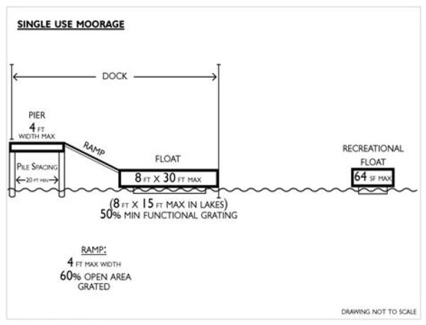
Figure 22.600.160(1). Mooring structure and recreational float dimensional requirements for single-use facilities.
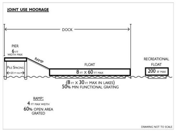
Figure 22.600.160(2). Mooring structure and recreational float dimensional requirements for joint-use facilities.
5. Floats.
a. All foam material whether used for flotation or for any other purpose must be encapsulated within a shell that prevents breakup or loss of the foam material into the water and is not readily subject to damage by ultraviolet radiation or abrasion.
b. Flotation shall not be installed under functional grating.
c. Floats and watercraft shall not ground out at low tide and shall not be permitted to rest landward of MLLW.
d. Floats shall be suspended at all times a minimum of one foot above the substrate. The preferred method is to suspend the float above the substrate by installing float stops on piling. The stops must be able to fully support the entire float during all tidal elevations. In some instances, stub pilings or float feet may be considered.
e. Single-use floats attached to piers shall not exceed eight feet in width and thirty feet (fifteen feet for lakes) in length. Functional grating must be installed on at least fifty percent of the surface area. See Figures 22.600.160(1) and 22.600.160(2) for illustration of single-use and joint-use moorage requirements.
f. Joint-use floats attached to piers shall not exceed eight feet in width and sixty feet (thirty feet for lakes) in length. Functional grating must be installed on at least fifty percent of the surface area. Exceptions to this standard may be permitted where need is demonstrated and where approved by the U.S. Army Corps of Engineers.
g. Single-use recreational floats shall not exceed sixty-four square feet in size and joint-use recreational floats shall not exceed two hundred square feet in size. In either case, the float must have at least fifty percent functional grating. See Figures 22.600.160(1) and 22.600.160(2) for illustration of single-use and joint-use moorage requirements.
h. Community recreational floats associated with public parks and other recreational facilities shall be a maximum of three hundred square feet in size.
6. Boat Launching Ramps, Railways and Lifts.
a. Private boat launches shall not extend below ordinary high water, unless they:
i. Are elevated; and
ii. Will result in no net loss of shoreline ecological functions; and
iii. Minimize aesthetic impacts.
b. Commercial or community boat launching ramps shall provide a wash-down drainage crypt which incorporates oil-water separators for the treatment and disposal of wastewater associated with the boat launching ramp.
c. Private marine rail systems are preferred over private boat launch ramps. Applicants shall demonstrate that the preferred option is infeasible before selecting the less preferred option.
d. Marine rail systems shall be maintained in operating condition or must be removed.
e. Marine rail systems shall be designed, to the greatest extent feasible, so they are not barriers to littoral drift.
f. Floating watercraft lifts shall be located greater than nine feet waterward from the OHWM.
g. The area of floating boat lifts to be installed on the over-water structure must be included in the float grating calculations.
7. Buoys and Anchors.
a. One mooring buoy may be permitted per residence, pursuant to the standards in this section.
b. Mooring buoys may be permitted at public parks, provided they are part of an approved park plan.
c. Mooring buoys and/or anchors shall not be used for moorage of live-aboard vessels. Other extended moorage or anchoring shall only be allowed in waters of the state when permission is obtained from the state, and impacts to navigation and public access are mitigated.
d. Mooring buoys shall have a helical anchor with a mid-line float and be located in water at least sixteen feet deep to minimize impacts to the substrate and aquatic vegetation, except where consultation with the appropriate state resource agency results in an alternate design due to site-specific conditions.
e. Mooring buoys are limited to use for vessels no longer than sixty feet in length.
f. Mooring buoys are subject to Washington Department of Natural Resources approval for placement in state-owned aquatic lands (RCW 79.105.430), and WDFW approval for any mooring buoy placement.
g. Recreational mooring buoys shall be registered with the department.
8. Lakes, Rivers and Streams.
a. Mooring structures shall be prohibited on rivers and streams.
b. No mooring structures shall be constructed within one hundred feet of the mouth of a river, stream or creek.
(Ord. 598 (2021) § 4 (Appx. 1), 2021)
22.600.165 Recreation and public access.
A. Environment Designations Permit Requirements. Where recreational development is proposed in the following designations, the identified permit requirements shall apply:
1. Natural:
a. Prohibited for non-water-oriented recreational development;
b. SDP for nonmotorized, water-oriented recreational development; and
c. CUP for all other forms of recreation, except where demonstrated to be consistent with approved park plans prior to application, and then with an SDP.
2. Rural conservancy, urban conservancy, shoreline residential, high intensity: SDP.
3. Aquatic: The required permit type will be determined by the specific recreational development proposed as set forth in this chapter. For example, see Section 22.600.125, Boating facilities.
B. Application Requirements. In addition to the general permit requirements, a description of how the proposed use is water-oriented is required if applicable.
C. Development Standards.
1. Recreational development shall not result in a net loss of shoreline ecological functions or ecosystem-wide processes.
2. All recreational facilities shall be designed, located and operated in a manner consistent with the purpose of the environment designation in which they are located.
3. Water-oriented recreation may be allowed in shoreline buffers. The removal of on-site native vegetation shall be limited to the minimum necessary for the recreational development areas, such as picnic areas, campsites, selected views, or other permitted structures or facilities.
4. Preference shall be given to activities which are consistent with approved state and local park plans for water-oriented recreational development.
5. Non-water-oriented recreational facilities, such as golf courses, playing fields, and facilities with extensive impervious surfaces, shall observe critical area buffers and vegetation conservation standards (Sections 22.400.115 and 22.400.120, respectively).
6. Commercial recreational development shall be consistent with Section 22.600.130 (Commercial development).
7. Vehicular traffic is prohibited on beaches, bars, spits and streambeds, except for permitted construction and boat launching, or in areas where it can be demonstrated that a historical use has been established.
8. Public road-ends, tax-title lands and rights-of-way adjacent to shorelines of the state shall be preserved for public access, unless the property is zoned for industrial uses. Pursuant to RCW 36.87.130, as now or hereafter amended, vacation of such shall only occur if the purpose is to:
a. Enable any public authority to acquire the vacated property for port purposes, boat moorage or launching sites; or
b. Provide for park, viewpoint, recreational, educational or other public purpose.
9. Trail access shall be provided to link upland facilities to the beach area where feasible and where impacts to ecological functions can be mitigated.
10. When applicable, recreational development shall make adequate provisions for:
a. Vehicular parking and pedestrian access;
b. Proper wastewater and solid waste disposal methods;
c. Security and fire protection;
d. The prevention of overflow and trespass onto adjacent properties, including, but not limited to, landscaping, fencing, and posting of property;
e. Screening of such development from adjacent private property to prevent noise and light impacts.
11. Shoreline trails and pathways shall be located, designed, and constructed to protect bank stability.
12. As required by RCW 90.58.100(4), applications providing for wilderness beaches, ecological study areas, and recreational uses for the public on state-owned shorelines shall be considered a preferred use.
13. Public access sites shall be made barrier-free and accessible for physically disabled uses where feasible, and in accordance with the Americans with Disabilities Act (ADA).
(Ord. 598 (2021) § 4 (Appx. 1), 2021)
22.600.170 Residential development.
A. Environment Designations Permit Requirements. Where residential development is proposed in the following designations, the identified permit requirements shall apply:
1. Natural:
a. CUP for primary single-family residences and subdivisions.
b. Prohibited for multifamily units and accessory dwelling units.
2. Rural conservancy and urban conservancy:
a. Primary single-family residences are exempt pursuant to criteria in Section 22.500.100(C).
b. SDP if exemption criteria not met.
c. CUP for multifamily units, accessory dwelling units and subdivisions.
3. Shoreline residential and high intensity:
a. Primary single-family residences are exempt pursuant to criteria in Section 22.500.100(C);
b. SDP if exemption criteria not met;
c. SDP for multifamily units, accessory dwelling units, and subdivisions; and
d. SDP for land segregation where complete application includes development within shoreline jurisdiction.
4. Aquatic: prohibited.
B. Development Standards.
1. All new residential development, including subdivision of land, shall be designed, configured and developed in a manner that ensures no net loss of shoreline ecological function.
2. All sewage disposal and water systems shall comply with state and local health regulations including but not limited to Kitsap County board of health Ordinance 2008A-01 for on-site sewage requirements.
3. New and remodeled residential development and new subdivisions shall be designed, located and constructed so that structural improvements, including bluff walls and other stabilization structures, are not required to protect such structures and uses.
4. New over-water residences, including floating homes, are prohibited. Where such homes were permitted or legally established prior to January 1, 2011, they shall be reasonably accommodated to allow improvements associated with life safety matters, property rights and considered a conforming use.
5. Stormwater quality and quantity measures for residential development must comply with current codes.
6. Flood hazard reduction measures for residential development shall comply with Chapter 19.500, as incorporated here by Section 22.400.115 (Critical areas), and Section 22.400.150 (Flood hazard reduction measures) and shall be designed to prevent net loss of shoreline ecological functions.
7. New multi-unit residential development, including the subdivision of land for five or more parcels, shall provide for joint or community and/or public access, except where demonstrated to be infeasible due to any of the following:
a. Incompatible uses;
b. Safety;
c. Security;
d. Impact to the shoreline environment;
e. Constitutional or other legal limitations that may be applicable.
8. In cases where on-site access is infeasible, alternate methods of providing public access shall be considered, such as off-site improvements.
9. Lot area shall be calculated using only those lands landward of the OHWM.
10. Single-family residential uses are a priority use only when developed in a manner consistent with control of pollution and prevention of damage to the natural environment.
(Ord. 598 (2021) § 4 (Appx. 1), 2021)
22.600.175 Shoreline stabilization.
A. Environment Designations Permit Requirements. Based on the type of shoreline modification proposed, the identified permit requirements shall apply for all designations:
1. SDP for soft shoreline stabilization, unless otherwise exempt.
2. Administrative CUP for hard shoreline stabilization.
3. Administrative CUP for hybrid shoreline stabilization, unless the applicant can demonstrate the project meets the intent of soft shore as described in Ecology’s Soft Shoreline Stabilization SMP Planning and Implementation Guidance (Ecology Publication No. 14-06-009).
4. Restoration and enhancement projects, including hybrid projects requiring hard shoreline stabilization to accommodate transition to adjacent properties, that are authorized in writing by both the shore friendly Kitsap program and by the Washington State Department of Fish and Wildlife shall require an SDP, unless otherwise exempt.
B. Exemptions from Substantial Development Permit for Shoreline Stabilization.
1. The construction of a normal protective bulkhead common to single-family residences shall not require an SDP if it meets the exemption criteria listed in Section 22.500.100(C)(3)(c), or as further amended in WAC 173-27-040.
2. A “normal protective” bulkhead includes those structural and nonstructural developments installed at or near, and parallel to, the OHWM for the sole purpose of protecting an existing single-family residence and appurtenant structures from loss or damage by erosion.
3. A letter of permit exemption will be prepared for qualifying shoreline stabilization activities in accordance with Section 22.500.100(C)(4). The county shall track exemption activities in the permit system.
C. Application Requirements. In addition to the general application requirements, applications for shore protection and bluff stabilization shall include the following information, when applicable:
1. Upland, on-site improvements and any existing shoreline structures;
2. Type of proposed shore protection and a description of alternatives to hard approaches where proposed, and a thorough discussion of the environmental impacts of each alternative;
3. Habitat survey prepared by a qualified professional biologist that describes the anticipated effects of the project on fish and wildlife resources and marine vegetation;
4. A description of any proposed vegetation removal, and a plan to revegetate the site following construction;
5. Tidal elevations and field-verified line of ordinary high water;
6. Ownership of the tidelands, shorelands and/or bedlands;
7. Purpose of shore protection;
8. Direction of net longshore drift (for marine shoreline);
9. Plan and profile of existing bank and beach;
10. Profile of adjacent existing bulkhead;
11. In addition to the general geotechnical report requirements in Section 22.700.120, the following information shall be included for shoreline stabilization proposals:
a. Address the need to prevent potential damage to a primary structure through the use of shoreline stabilization measures.
b. Estimate time frame and rates of erosion to report on the urgency associated with the specific situation. “Urgent” means:
i. That the primary structure will be damaged within three years as a result of natural shoreline erosion in the absence of hard armoring structures; or
ii. Where waiting until the need is that immediate would foreclose the opportunity to use measures that avoid impacts on ecological functions.
c. If the report determines that the need is not as immediate as three years, it still may be used to justify a more immediate authorization to protect against erosion using soft measures.
d. The geotechnical analysis shall evaluate on-site drainage issues and address drainage problems away from the shoreline edge;
12. Any other information that may be required to demonstrate compliance with the review criteria referenced in this section and the guiding provisions at WAC 173-26-231(3)(a).
D. Development Standards.
1. General Regulations.
a. These standards shall be guided by the provisions at WAC 173-26-231(3)(a).
b. Applications for shore protection will be reviewed pursuant to comments made by the Washington Department of Fish and Wildlife pertaining to impacts on critical salt and freshwater habitats, and comments made by the Washington Department of Natural Resources for projects proposed on state-owned aquatic lands.
c. Soft shoreline stabilization measures shall be utilized unless demonstrated through a geotechnical analysis not to be sufficient to protect primary structures, dwellings and businesses. Alternatives for shoreline stabilization shall be based on the following order of preference:
i. No action, increase building setbacks, or relocate structures;
ii. Soft shoreline stabilization constructed of natural materials including bioengineering, beach nourishment, protective berms, or vegetative stabilization;
iii. Hybrid shoreline stabilization, usually constructed of a mix of rock, logs and vegetation;
iv. Hard shoreline stabilization constructed of materials such as rock, riprap or concrete.
d. Soft shoreline stabilization measures that provide restoration of shoreline ecological functions may be permitted waterward of the OHWM.
e. Hybrid shoreline structural stabilization projects, with the exception of restoration and enhancement projects, composed of hard shoreline stabilization that cumulatively covers greater than fifteen percent of the total shoreline length parallel to the OHWM shall comply with hard shoreline stabilization project requirements in this section.
f. When hard shoreline stabilization measures are demonstrated to be necessary, they must:
i. Limit the size of stabilization measures to the minimum necessary.
ii. Assure no net loss of shoreline ecological functions.
iii. Ensure that publicly financed or subsidized shoreline erosion control measures do not restrict appropriate public access to the shoreline except where such access is determined to be infeasible because of incompatible uses, safety, security, or harm to ecological functions.
iv. Where feasible, incorporate ecological restoration and public access improvements into the project.
g. Shoreline stabilization measures shall not be for the purpose of creating dry land. Leveling or extending property, creating or preserving residential lawns, yards or landscaping shall not be allowed except when otherwise allowed in this section due to health and safety.
h. Minimize disturbance pertaining to beach access by avoiding switchback trails which require hard stabilization. Where such avoidance is not feasible, mitigation for impacts to shoreline ecological functions shall be required.
i. Bluff stabilization walls shall be prohibited unless proven necessary through a geotechnical report.
j. Placement of shoreline stabilization methods shall follow the natural contour of the existing shoreline, be parallel to and at or above the OHWM.
k. Shoreline stabilization on marine feeder bluffs, when determined necessary pursuant to the standards of this section, may require additional mitigation measures, including those necessary to offset the loss of sediment supply.
l. Shoreline stabilization must be designed by a professional engineer licensed in the state of Washington with demonstrated experience in hydraulic activities of shorelines. Alternatively, soft shoreline stabilization may be designed by a habitat biologist or a professional with demonstrated expertise in designing soft shoreline stabilization structures.
m. Depending on the degree of hard or soft elements to the project, the department, WDFW, and/or U.S. Army Corps of Engineers may require varying degrees of mitigation or other permit conditions.
n. Shoreline stabilization structures shall not result in a net loss of shoreline ecological functions.
o. Shoreline stabilization, as applied in this section, is generally distinguished from shoreline restoration activities. However, specific shoreline stabilization elements of restoration activities shall be guided by this section.
2. New and Expanded Shoreline Stabilization.
a. If shoreline stabilization is necessary pursuant to a geotechnical analysis, the method, either hard or soft, shall not result in a net loss of shoreline ecological functions. To meet this requirement, on- and off-site mitigation measures may be required.
b. Shoreline stabilization structures shall not be constructed with waste materials such as demolition debris, derelict vessels, tires, concrete or any other materials which might have adverse toxic or visual impacts on shoreline areas.
c. New structural stabilization measures shall not be allowed except when necessity is demonstrated in the following manner:
i. To protect legally existing primary structures:
(A) New or enlarged structural shoreline stabilization measures for the existing primary structure, including residences and their primary appurtenant structures or uses, shall not be allowed unless there is conclusive evidence, documented by a geotechnical analysis, that the lawfully established, primary structure is in imminent danger from shoreline erosion caused by tidal actions, currents, or waves;
(B) Normal sloughing, erosion of steep bluffs, or shoreline erosion itself, without a scientific or geotechnical analysis, is not demonstration of need;
ii. In support of water-dependent development when all of the following apply:
(A) The erosion is not being caused by upland conditions, such as the loss of vegetation and drainage;
(B) Nonstructural measures, planting vegetation, or installing on-site drainage improvements is not feasible or not sufficient;
(C) The need to protect primary structures from damage due to erosion is demonstrated through a geotechnical report;
iii. In support of new non-water-dependent development, including single-family residences, when all of the following apply:
(A) The erosion is not being caused by upland conditions, such as the loss of vegetation and drainage;
(B) Nonstructural measures, such as placing the development further from the shoreline, planting vegetation, or installing on-site drainage improvements, are not feasible or not sufficient;
(C) The need to protect the primary structures from damage due to erosion is demonstrated through a geotechnical report. The damage must be caused by natural processes, such as tidal action, currents and waves;
iv. To protect projects for the restoration of ecological functions or hazardous substance remediation projects pursuant to Chapter 70.105D RCW when nonstructural measures, planting vegetation, or installing on-site drainage improvements is not feasible or sufficient.
3. Replacement and Repair of Existing Shoreline Stabilization and Armoring.
a. Additions to or increases in the size of existing shoreline stabilization measures shall be considered new structures.
b. An existing stabilization structure may be replaced with a similar structure if there is a demonstrated need, through a geotechnical report, to protect principal uses or structures from erosion caused by currents, tidal action or waves.
c. If the OHWM has been re-established, the replacement structure must be located at or near the new OHWM. In general, replacement of the shoreline stabilization structure within one year of damage will ensure recognition of the previous OHWM.
d. Alternative or soft stabilization approaches shall be considered prior to in-kind replacement.
e. The replacement structure shall:
i. Be designed, located, sized and constructed to assure no net loss of ecological functions.
ii. Perform the same stabilization function of the existing structure and does not require additions to or increases in size.
iii. Not encroach waterward of the OHWM or existing structure unless the residence was occupied prior to January 1, 1992, and there are overriding safety or environmental concerns. In such cases, the replacement structure shall abut the existing shoreline stabilization structure.
f. When possible or as an element of mitigation sequencing, failing, harmful, unnecessary, or ineffective structures should be removed, and shoreline ecological functions and processes should be restored using nonstructural or soft and/or long-term stabilization measures.
4. Shore Stabilization on Streams.
a. Hard shoreline stabilization methods are prohibited in jurisdictional shoreline streams on estuarine shores, in wetlands, and in salmon spawning areas, except for the purpose of fish or wildlife habitat enhancement or restoration, or when deemed necessary through a geotechnical report to protect an existing primary structure.
b. All revetments or similar structures shall be designed in accordance with WDFW Integrated Streambank Protection Guidelines.
5. Use of shoreline armoring to protect a platted lot where no primary use or structure presently exists shall be prohibited.
(Ord. 598 (2021) § 4 (Appx. 1), 2021)
22.600.180 Transportation.
A. Environment Designations Permit Requirements. Where transportation is proposed in the following designations, the identified permit requirements shall apply. Note: New trail construction shall be regulated under applicable recreation and public access (Section 22.600.165) provisions.
1. Natural: prohibited, except to serve essential transportation corridors or in support of permitted uses and activities, and then with a CUP.
2. Rural conservancy and urban conservancy: a CUP is required, unless the proposal is necessary to protect existing public roads within existing rights-of-way.
3. Shoreline residential and high intensity: SDP.
B. Development Standards.
1. New transportation facilities and maintenance of existing transportation facilities shall be carried out in a manner that will: (a) avoid a net loss of shoreline ecological functions, and (b) result in a net improvement in ecological functions where feasible and appropriate. Unavoidable adverse impacts shall be mitigated.
2. Parking facilities shall only be allowed when:
a. Necessary to support an authorized use; and
b. No net loss of ecological functions can be demonstrated; and
c. Visual impacts are minimized.
3. New or expanded transportation routes in the shoreline jurisdiction, including associated wetlands, shall to the greatest extent feasible:
a. Be located in areas that do not require shoreline stabilization, dredging, extensive cut/fill and other forms of shoreline alteration;
b. Be limited to local access and public shoreline access routes;
c. Be located in existing rights-of-way and corridors; and/or
d. Not be built within shoreline jurisdiction when reasonable or practicable alternatives exist.
4. Provision shall be made for sufficient view points, rest areas, and picnic areas in public shorelines, where feasible. In addition, bike paths and walking paths shall be incorporated into road designs.
5. All proposed road, bridge or railroad crossings shall be designed to cross at the shortest, most direct route, except where such design would result in a net loss of shoreline ecological functions or is prohibited by topography.
6. Bridge approach fill shall not encroach in the floodway of any stream or river.
7. All public bridges shall include sidewalks for pedestrian use if sidewalks exist or are planned for connecting roadways.
8. All bridges and culverts shall be large enough to pass the one-hundred-year flood waters with consideration for debris flow likely to be encountered, or designed to the standards of the WDFW Aquatic Habitat Guidelines.
9. All bridges intended for use by motorized vehicles shall be designed for emergency vehicle weight loads.
10. Roads and bridges located in wetland areas shall be designed and maintained to prevent erosion and to permit the natural movement of groundwater to the greatest extent feasible.
11. Transit Facilities. To the extent feasible, transit facilities such as bus stops and shelters shall be located and designed consistent with subsection (B)(3) of this section. Park and ride facilities shall meet the standards of this subsection (B). All other performance standards of this subsection (B) shall apply.
12. Public Transit – Ferries. See Section 22.600.125 (Boating facilities).
(Ord. 598 (2021) § 4 (Appx. 1), 2021)
22.600.185 Utilities.
A. Environment Designations Permit Requirements. Where utilities are proposed in the following designations, the identified permit requirements shall apply.
1. Natural: prohibited, except to serve essential utility corridors or in support of permitted uses and activities, and then with a CUP. Utilities associated with single-family residences are exempt.
2. Rural conservancy, urban conservancy, shoreline residential, high intensity: SDP. Utilities associated with single-family residences are exempt.
3. Aquatic: CUP.
B. Application Requirements. All applications for utility facilities shall include, at a minimum, the following:
1. Reason why facility must be located in the shoreline jurisdiction;
2. Alternative locations considered and reasons for their rejection;
3. Location of other facilities near the proposed project and if the location is to include other types of facilities;
4. Proposed method of construction and plans to control erosion and turbidity during construction;
5. Plans for restoration of areas disturbed during construction;
6. Possibility of locating proposed facility within existing utility right-of-way; and
7. Geotechnical report when proposed in a geologically hazardous area.
C. Development Standards.
1. General Regulations.
a. On-site utility features serving a primary use, such as a water, sewer or gas line to a residence, are accessory utilities and shall be considered a part of the primary use.
b. All utility facilities shall be designed and located to assure no net loss of shoreline ecological functions, preserve the natural landscape, and minimize conflicts with present and planned land and shoreline uses while meeting the needs of future populations in areas planned to accommodate growth per the Kitsap County Comprehensive Plan.
c. Non-water-oriented utility production and processing facilities shall not be allowed in shoreline jurisdiction unless it can be demonstrated that no other feasible option is available.
d. Transmission facilities shall be located outside of the shoreline area where feasible. When located in the shoreline area, they must be constructed, designed and located to assure no net loss of shoreline ecological functions.
e. Utilities shall be located in existing rights-of-way and corridors whenever possible.
f. New or expanded utility facilities shall be located in areas that do not require shoreline stabilization, dredging, extensive cut/fill and other forms of shoreline alteration to the greatest extent feasible.
g. Maintenance of existing utilities shall be carried out in a manner that will not result in a net loss of shoreline ecological functions, and any unavoidable adverse impacts shall be mitigated. This includes minimization of vegetation removal, and mitigation of any adversely affected area.
h. Where feasible and consistent with shoreline ecological functions, new and replacement utility lines shall be underground.
i. Development of pipelines and cables on tidelands and development of facilities that may require periodic maintenance that disrupts shoreline ecological functions should be prohibited unless no other feasible alternative exists. When allowed, the location, design and construction of such facilities shall not result in a net loss of shoreline ecological functions or significant impacts to the other shoreline resources and values.
2. Sewage Treatment Plants and Outfalls.
a. Where allowed, sewage treatment plant outfalls shall be below the extreme low water mark and are permitted only where adequate natural water circulation can be provided.
b. Sewage facilities shall be located within existing rights-of-way when feasible.
c. To the maximum extent possible, sewage treatment plant outfalls shall be located where their effluent will not negatively impact commercial and recreational shellfish and other critical habitat and marine resource areas. Mitigation may be required for any adverse impacts to fisheries and wildlife resources, natural systems and sensitive areas.
d. Discharge of untreated effluent over or into the shorelines of the county is prohibited.
(Ord. 598 (2021) § 4 (Appx. 1), 2021)