


Chapter 16.16
ENVIRONMENTALLY CRITICAL AREAS
Sections:
16.16.020 Critical areas protected.
16.16.050 Maps and study – Adoption.
16.16.060 Critical area – Authority of planning director – Review process.
16.16.070 Applications – Content – Fee.
16.16.080 Applications – Approval – Permits – General condition.
16.16.090 Applications – Approval – Criteria – Revocation.
16.16.100 Critical area – Special study requirement.
16.16.110 Contents of critical areas study.
16.16.120 Mitigation and monitoring.
16.16.130 Mitigation sequencing.
16.16.160 Vegetation management plan.
16.16.170 Critical areas – Markers and signs.
16.16.180 Critical areas – Conservation easements and critical area tracts.
16.16.190 Disclosure and notice to title.
16.16.200 Performance standards for subdivisions.
16.16.230 Authorized work in critical areas.
16.16.250 Reasonable use exception to allow for reasonable economic use.
16.16.260 Public agency and utility exception.
16.16.280 Erosion hazard areas – Development standards – Permitted alterations.
16.16.290 Landslide hazard areas – Development standards – Permitted alterations.
16.16.300 Seismic hazard areas – Development standards – Permitted alterations.
16.16.310 Steep slope hazard areas – Development standards – Permitted alterations.
16.16.320 Wetlands – Development standards.
16.16.330 Wetlands – Permitted alterations.
16.16.340 Wetlands – Mitigation and restoration requirements.
16.16.350 Streams – Classifications.
16.16.355 Streams – Development standards.
16.16.360 Streams – Permitted alterations.
16.16.370 Streams – Mitigation requirements.
16.16.380 Fish and wildlife habitat conservation areas.
16.16.410 Critical aquifer recharge areas – Designation.
16.16.420 Critical aquifer recharge areas – Development standards.
16.16.450 Frequently flooded areas.
16.16.010 Purpose.
The provisions of this chapter implement the goals and policies of the Washington State Growth Management Act, the Lake Forest Park Municipal Code, the Washington State Environmental Policy Act and the comprehensive plan for the city of Lake Forest Park to protect the public health and safety and to protect the natural environment, in particular the Lyon and McAleer creek basins, but also all critical areas of the city, including their structures, functions and values.
This chapter is adopted, in part, to:
A. Protect critical areas;
B. Protect unique, fragile and irreplaceable elements of the environment;
C. Protect public and private property from damage due to landslide, seismic hazard, flooding, sedimentation, or erosion;
D. Minimize stormwater runoff;
E. Prevent losses from turbidity and pollution of wetlands and fish-bearing waters such as lakes and streams which are used in the life cycles of anadromous salmon, steelhead, or other species of fish and to maintain wildlife habitat;
F. Achieve a goal of no net loss of wetland function, value, and acreage within each drainage basin;
G. Maintain stream, habitat and riparian corridor functions; and
H. Provide the planning director and others with decision making authority with supplemental information for use concerning public or private development or work that affects critical areas, including decisions to approve or deny an application or to impose conditions thereon, and for use by the city with respect to determinations under the State Environmental Policy Act, Chapter 43.21C RCW, the Washington Administrative Code provisions, and city ordinances adopted in conjunction therewith. (Ord. 1150 § 1, 2017; Ord. 930 § 2, 2005)
16.16.020 Critical areas protected.
Unless expressly authorized herein, any alteration of or work in or development of critical areas and their buffers is prohibited. (Ord. 1150 § 1, 2017; Ord. 930 § 2, 2005)
16.16.030 Applicability.
A. The provisions of this chapter shall apply to development proposals for sites in the city outside of shoreline jurisdiction on which are located critical areas or critical area buffers or that are contiguous to critical areas or critical area buffers. Critical areas (environmentally sensitive areas) within shoreline jurisdiction are regulated through the city’s shoreline master program in Chapter 16.18 LFPMC.
B. Whenever the planning director determines that a development proposal is for a site described in LFPMC 16.16.020, all work shall be performed and all construction completed in compliance with critical area permits issued by the city according to the requirements of this chapter. Permit decisions shall be Type III decisions and processed according to Chapter 16.26 LFPMC.
C. The decision of the city to issue a critical area permit conditioned by the requirements of this chapter does not relieve the applicant from complying with all other applicable city ordinances and plans. In case of a conflict among LFPMC provisions, the more stringent shall apply. (Ord. 1150 § 1, 2017; Ord. 930 § 2, 2005)
16.16.040 Definitions.
Words and phrases used in this chapter shall have the meaning set forth in this section. Undefined words and phrases that are defined in LFPMC Title 18 shall have the meaning ascribed therein unless the context clearly requires otherwise or another code provision is referenced. For purposes of interpretation, the present tense includes the future, the singular form includes the plural, and the plural form includes the singular. “Shall” is mandatory and not discretionary. The words “person” or “applicant” shall include an individual(s), a corporation, partnership or other legal entity. Whenever a specific document or regulation is referenced herein, the reference shall refer to the most recent edition of such document or regulation, unless the context clearly indicates otherwise.
A. “Alteration” means any human activity that results or might result in any impact upon a critical area; provided, that alteration does not include walking, fishing, or any other passive recreation or other similar activities.
B. “Best management practices” means regularly accepted principles and practices or systems of practices and management measures that are recommended by a qualified professional as most likely to:
1. Control soil loss and reduce water quality degradation caused by high concentrations of nutrients, animal waste, toxics, and sediment;
2. Minimize adverse impacts to surface water and groundwater flow, circulation patterns, and to the chemical, physical, and biological characteristics of streams and wetlands;
3. Protect trees and vegetation designated to be retained during and following site construction;
4. Protect wildlife habitat; and
5. Protect and enhance critical areas and their function and values.
C. “Buffer” means an area contiguous to a critical area that is established to protect the critical area.
D. “Critical areas” means wetlands; streams; areas with a critical recharging effect on aquifers used for potable water; fish and wildlife habitat conservation areas; frequently flooded areas; and geologically hazardous areas such as erosion hazard areas, landslide hazard areas, seismic hazard areas, and steep-slope hazard areas. “Critical areas” also means and includes any buffers established by this chapter, or any buffer or setback established by state law or other city ordinance that serves to protect critical areas. “Critical areas” also means and includes critical areas that are located on neighboring lots.
E. “Development proposal” means any proposed activity relating to the use and/or development of land requiring a permit or approval from the city.
F. “Enhancement” means an action which increases the functions and values of a stream, wetland or other critical area.
G. “Erosion hazard area” means an area with soil characteristics that, according to the USDA Soil Conservation Service Soil Classification System, may experience severe to very severe erosion hazard, including slopes greater than 15 percent with erodible soils that are exposed. Any activity which exposes erodible soils to rainfall or running water will create erosion hazard conditions on slopes greater than 15 percent. Soils which are particularly susceptible to erosion include fill constructed of virtually all soil types, loose sandy native soils such as Vashon recessional outwash (Qvr), Esperance sand (Qe), Vashon till (weathered Qvt), and the dense fine-grained clay (Qcl). Improper fill methods, especially near flowing water, can produce an erosion hazard in areas not identified as hazard areas.
H. “Fish and wildlife habitat conservation area” means an area that is managed for maintaining populations of species in suitable habitats within their natural geographic distribution so that the habitat available is sufficient to support viable populations over the long term and isolated subpopulations are not created, as defined in WAC 365-190-130 and RCW 36.70A.030. Fish and wildlife habitat conservation areas also include nonaquatic areas that serve a critical role in sustaining needed habitats and species for the functional integrity of the ecosystem, and which, if altered, may reduce the likelihood that the species will persist over the long term. These areas may include, but are not limited to, rare or vulnerable ecological systems, communities, and habitat or habitat elements including seasonal ranges, breeding habitat, winter range, and movement corridors; and areas with high relative population density or species richness. These lands are managed for maintaining species in a wild state in suitable habitats within their natural geographic distribution so that isolated subpopulations are not created. “Fish and wildlife habitat conservation areas” that must be considered for classification and designation include:
1. Priority habitats;
2. Areas where endangered, threatened, and sensitive species, or priority species, have a primary association;
3. Naturally occurring ponds under 20 acres and their submerged aquatic beds that provide fish or wildlife habitat;
4. Waters of the state;
5. Lakes, ponds, streams and rivers planted with game fish by a governmental or tribal entity; or
6. State natural area preserves and natural resource conservation areas.
I. “Landslide” means any episodic downslope movement of a mass including, but not limited to, soil, rock or snow.
J. Landslide Hazard Areas.
1. “Landslide hazard areas” means slopes that are potentially subject to landslides. All landslide hazard areas are classified as:
a. “Class I”: a slope that is less than 15 percent and is considered relatively stable;
b. “Class II”: a slope that is greater than 15 percent and is underlain by permeable soils that are relatively stable in their natural state but may become unstable if slope configurations or draining conditions are modified;
c. “Class III”: a slope that is greater than 15 percent and is underlain by impermeable soils, and may be characterized by springs or seeping groundwater during the wet season.
2. “Landslide hazard areas” include Class II and Class III if any of the following are present:
a. Any area that has shown movement during the Holocene epoch (from 10,000 years ago to present) or which is underlain by significant waste debris of that epoch; or
b. An area potentially unstable as a result of rapid stream incision, stream bank erosion or undercutting; or
c. Any area located on an alluvial fan or delta potentially subject to inundation by debris flows; or
d. Any area with a slope of 40 percent or greater and with a vertical relief of 10 or more feet except any area composed of consolidated rock.
K. “Light equipment” means hand-held tools and construction equipment, such as handsaws, wheelbarrows, and post-hole diggers.
L. “Mitigation” means any of the following actions or combination of actions:
1. Avoiding impacts to environmentally critical areas by avoiding actions or parts of actions;
2. Minimizing impacts by limiting the degree of an action and its implementation by affirmative acts designed to avoid or reduce impacts;
3. Rectifying the impact by repairing, rehabilitating, or restoring the affected environment;
4. Reducing or eliminating the impact or hazard over time by preservation and maintenance operations during the life of the action;
5. Compensating for an impact by replacing, enhancing, or providing for substitute resources or environments;
6. Monitoring the impact and/or hazard and making appropriate corrective measures.
M. “Monitoring” means the evaluation of the impacts of development proposals on biologic, hydrologic and geologic systems through the collection and analysis of data over a designated period of time and producing periodic reports for the purpose of understanding and documenting changes in natural ecosystems, functions and features.
N. “Pervious material” means any material that permits full or partial absorption of stormwater into previously unimproved land.
O. “Priority habitats” means a habitat type with unique or significant value to one or more species as defined in WAC 173-26-020.
P. “Priority species” means those species requiring protective measures and/or management guidelines to ensure their persistence at genetically viable population levels based on the criteria in WAC 173-26-020.
Q. “Qualified professional” means a person with experience and training in the pertinent scientific discipline, and who is a qualified scientific expert with expertise appropriate for the relevant critical area subject according to WAC 365-195-905(4). A qualified professional must also have obtained a Bachelor of Science or Bachelor of Arts or equivalent degree in biology, engineering, environmental studies, fisheries, geomorphology, or related field, with at least three years’ experience in the related profession, such as botany, wetlands, fisheries, wildlife, soils, ecology, and similar areas of specialization; provided, that a qualified professional for:
1. Habitat must have a degree from an accredited college or university in biology and professional experience related to the subject species.
2. Wetlands must be a certified professional wetlands scientist or have, at a minimum: (a) a bachelor’s degree in hydrology, soil science, biology, botany, ecology, or related field; and (b) at least two years of full-time work experience as a wetlands professional, including experience in delineating wetlands using the state or federal manuals, preparing wetland reports, conducting function assessments, and developing and implementing mitigation plans.
R. “Recommended development practices” means guidelines for development in or near critical areas as may be utilized by the planning director from time to time.
S. “Restorations” or “restoration” means the actions or action taken to return a critical area to a state in which the stability, functions and values approach the natural state as closely as possible.
T. “Salmonid” means a member of the fish family salmonidae, which include chinook, coho, chum, sockeye, and pink salmon; rainbow, steelhead, and cutthroat trout; brown trout; bull trout; brook and dolly varden; char; kokanee and whitefish.
U. “Seismic hazard areas” means areas underlain by low-strength fill and floodplain deposits with soil and groundwater conditions that are more susceptible to seismic hazards than other areas.
V. “Setback” means the area delineated on a development proposal site permit that separates building structures from critical area buffers present on the development site or on neighboring lots, unless otherwise specified in this chapter.
W. “Slope” means an inclined ground surface, the inclination of which is expressed as a ratio (percent) of vertical distance to the horizontal distance, using the formula: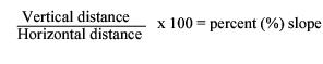
A slope is delineated by establishing its toe and top and measured by averaging the inclination over at least 10 feet of vertical relief.
1. “Steep slope hazard areas” means areas not composed of consolidated rock with slope gradients of 40 percent or greater within a vertical elevation change of at least 10 feet.
2. “Toe of a slope” is a distinct topographic break in slope that separates slopes inclined at less than 40 percent from slopes equal to or in excess of 40 percent. Where no distinct break exists, the toe of a steep slope is the lowermost limit of the area where the ground surface drops 10 feet or more vertically within the horizontal distance of 25 feet.
3. “Top of a slope” is a distinct, topographic break in slope that separates slopes inclined at less than 40 percent from slopes equal to or in excess of 40 percent. Where no distinct break in slope exists, the top of the slope shall be the uppermost limit of the area where the ground surface drops 10 feet or more vertically within a horizontal distance of 25 feet.
X. “Streams” means an area where open surface water produces a defined channel or bed, not including irrigation ditches, canals, storm or surface water runoff devices, or other entirely artificial watercourses, unless they are used by salmonids or are used to convey a watercourse naturally occurring prior to construction. A channel or bed need not contain water year-round, provided there is evidence of at least intermittent flow during years of normal rainfall.
Y. “Utilities” means facilities providing services to lots within the city through wires, pipes, or lines provided by a public or private utility. “Utilities” do not include wireless facilities.
Z. “Wellhead protection area” means the surface and subsurface area surrounding a water well or wellhead, supplying a public water system, through which contaminants are reasonably likely to move toward and reach such water well or wellhead.
AA. “Wetlands” means areas that are inundated or saturated by surface water or groundwater at a frequency and duration sufficient to support, and that under normal circumstances do support, a prevalence of vegetation typically adapted for life in saturated soil conditions. Wetlands generally include swamps, marshes, bogs, and similar areas. Wetlands do not include those artificial wetlands intentionally created from nonwetland sites, including, but not limited to, irrigation and drainage ditches, grass-lined swales, canals, detention facilities, wastewater treatment facilities, farm ponds, and landscape amenities, or those wetlands created after July 1, 1990, that were unintentionally created as a result of the construction of a road, street, or highway. Wetlands may include those artificial wetlands intentionally created from nonwetland areas created to mitigate conversion of wetlands. Identification of wetlands and delineation of their boundaries pursuant to this chapter shall be done in accordance with the approved federal wetland delineation manual and applicable regional supplements. Wetland delineations are valid for five years; after such date the city shall determine whether a revision or additional assessment is necessary.
To differentiate between levels of wetland protection and the application of development standards, wetlands shall be rated according to the Washington Department of Ecology wetland rating system, as set forth in the Washington State Wetland Rating System for Western Washington: 2014 Update (Ecology Publication No. 14-06-029, or as revised and approved by Ecology), which contains the definitions and methods for determining whether the criteria below are met. Wetland rating categories shall not change due to illegal modifications made by the applicant or with the applicant’s knowledge.
1. Category I wetlands are:
a. Wetlands of high conservation value that are identified by scientists of the Washington Natural Heritage Program/DNR;
b. Bogs;
c. Mature and old-growth forested wetlands larger than one acre; and
d. Wetlands that perform many functions well (scoring 23 points or more).
2. Category II wetlands are wetlands with a moderately high level of functions (scoring between 20 and 22 points).
3. Category III wetlands are:
a. Wetlands with a moderate level of functions (scoring between 16 and 19 points); and
b. Can often be adequately replaced with a well-planned mitigation project.
4. Category IV. Category IV wetlands have the lowest levels of functions (scoring fewer than 16 points) and are often heavily disturbed.
BB. “Wetland boundary” means the line delineating the outer edge of a wetland as determined by a qualified professional using the approved federal wetland delineation manual and applicable regional supplements as required by RCW 36.70A.175.
CC. “Wetland functions” means the natural processes performed by wetlands, including functions that are important in facilitating food chain production, providing sites for nesting, rearing and resting for aquatic, terrestrial and avian species, maintaining the availability and quality of water, acting as recharge and discharge areas for groundwater aquifers and moderating surface and stormwater flows, as well as performing other functions including, but not limited to, those set forth in the U.S. Army Corps of Engineers regulations at 33 C.F.R. Section 320.4(b)(2), 1988. (Ord. 1150 § 1, 2017; Ord. 930 § 2, 2005)
16.16.050 Maps and study – Adoption.
A. The approximate location and extent of critical areas are shown on the critical area maps adopted by the city of Lake Forest Park, as most recently updated. The following critical area maps are hereby adopted:
1. City of Lake Forest Park official critical area maps known as the “Lake Forest Park Critical Areas Mapping Project,” completed in December 1991, and updates that are the result of sensitive areas studies by a qualified professional subject to planning director approval. Updates and original plates may be consolidated into a new official map subject to approval of the planning director.
2. Washington Department of Fish and Wildlife Priority Habitat and Species Maps;
3. Lake Forest Park Water District Map of Critical Aquifer Recharge Area Susceptibility Zones, 2017.
4. Lake Forest Park Stewardship Foundation map of streams, wetlands, parks and open space known as “A Salmon’s Guide to Lake Forest Park,” copyright 2001.
B. These maps are for the guidance of the city of Lake Forest Park, project applicants, and/or property owners. They are a reference and do not provide a final critical area designation or delineation. (Ord. 1150 § 1, 2017; Ord. 930 § 2, 2005)
16.16.060 Critical area – Authority of planning director – Review process.
A. The planning director is authorized to administer this chapter and to make all decisions required by this chapter unless specifically provided otherwise.
B. The planning director shall perform a review for any development proposal permit application or other request for permission to proceed with an alteration on a site to:
1. Determine whether any critical area exists on the property and confirm its nature and type;
2. Determine whether a critical area study is required and, if so, the nature of that study;
3. Evaluate the critical area study;
4. Determine whether any proposed alteration to the critical area is necessary; and
5. Determine whether the mitigation and monitoring plans and bonding measures proposed by the applicant are sufficient to protect the public health, safety and welfare, consistent with the purposes of this chapter. (Ord. 1150 § 1, 2017; Ord. 930 § 2, 2005)
16.16.070 Applications – Content – Fee.
A. Whenever the planning director determines that work on or development of a site will affect a critical area, an application for a critical area permit shall be filed with the planning director on forms provided by the city.
B. The applicant is responsible for providing and the application shall include information known to the applicant indicating whether the subject property is located in, adjacent to, contains, or has characteristics of an environmentally critical area as defined in this chapter or other adopted ordinances. The applicant responsibility includes informing the planning director of the discovery of critical areas during the development process that had not been earlier discovered or disclosed.
C. An application shall not be complete until:
1. The applicant has submitted a study prepared by a qualified professional that identifies and assesses any critical areas and buffers located on or adjacent to the proposed development site and the potential impacts to the critical areas; and
2. The applicant has executed a hold harmless and release agreement in a form approved by the city releasing the city from liability from any damages arising from action or inaction taken under the city issued permit within the critical area or critical area buffer; and
3. The applicant has agreed that should the applicant fail to perform mitigation and monitoring as required the city may enter onto the property for the purpose of mitigation and monitoring as required by city permit at the applicant’s expense; and
4. The applicant has paid the fee established by the city council. An applicant shall be responsible for all costs associated with the employment of qualified professionals and any review conducted by city employees or city-retained consultants. The planning director may require a deposit to pay for city expenses related to the application as a condition of approval. (Ord. 1150 § 1, 2017; Ord. 930 § 2, 2005)
16.16.080 Applications – Approval – Permits – General condition.
A. In accordance with the provisions of this chapter, the planning director may approve, deny, or approve with conditions any application for a critical area permit. The planning director’s decision shall be in writing that sets forth the basis of the decision and cites the relevant code provision. Critical area permits shall be of two types:
1. A major critical area permit shall be required for all activities subject to this chapter, including, but not limited to, any activity that requires earth-moving equipment, except as provided in subsection (A)(2) of this section.
2. A minor critical area permit shall be required for all activities:
a. Performed only by light equipment.
b. Authorized by LFPMC 16.16.230 and performed only by light equipment.
c. Authorized by the setback exceptions of LFPMC 16.16.240.
B. All work authorized by a critical area permit shall be conducted using the best management practices that result in the least amount of impact to the critical areas, including for tree and vegetation protection, construction management, erosion and sedimentation control, water quality protection, and regulation of chemical applications. The city may observe the use of best management practices as necessary to ensure that the activity does not result in degradation to the critical area. Any damage to, or alteration of, a critical area shall be restored, rehabilitated, or replaced as determined by the planning director at the responsible party’s expense. (Ord. 1150 § 1, 2017; Ord. 930 § 2, 2005)
16.16.090 Applications – Approval – Criteria – Revocation.
A. The planning director shall make final critical area determinations and issue critical area permits according to the requirements of this chapter, best available science, and critical area studies prepared by qualified professionals.
B. The planning director is authorized to conduct review of the critical area study submitted by the applicant using a qualified professional to verify the study’s findings, conclusions and recommendations. Before initiating a professional review, the city shall inform the applicant of the review and anticipated expense.
C. When reviewing an application, the planning director may consider any recommended development practices that may be used in conjunction with the adopted critical areas map and study including those referenced in LFPMC 16.16.050. Recommended development practices may serve as a guideline for interpretation of both the study and critical areas map.
D. A permit issued on the basis of false information provided by the applicant is void and the holder of such permit shall have no rights thereunder. (Ord. 1150 § 1, 2017; Ord. 930 § 2, 2005)
16.16.100 Critical area – Special study requirement.
A. An applicant for a development proposal on a site determined by the planning director to be subject to the requirements of this chapter shall submit a critical area study that in the judgment of the planning director adequately evaluates the proposal and all probable impacts to the satisfaction of the planning director.
B. The planning director may require information from the applicant in addition to the critical area study as necessary to ensure compliance with this chapter. (Ord. 1150 § 1, 2017; Ord. 930 § 2, 2005)
16.16.110 Contents of critical areas study.
A. Critical area studies shall be in writing and:
1. Identify and characterize critical area(s) as a part of a larger development proposal site;
2. Assess all hazards posed by the development proposal to any critical areas or critical area buffers on or adjacent to the proposed site;
3. Propose adequate mitigation, maintenance, monitoring and contingency plans and bonding measures, if necessary;
4. Provide a scale map of the development proposal site;
5. Provide detailed studies, as required.
B. Critical area studies shall incorporate the best available science.
C. The planning director may permit a critical area study to incorporate studies required by other laws and regulations or other critical area studies performed under this chapter. (Ord. 1150 § 1, 2017; Ord. 930 § 2, 2005)
16.16.120 Mitigation and monitoring.
A. The planning director may require such mitigation as may be indicated as beneficial by the critical area study.
B. Mitigation of critical area impacts shall be conducted according to an approved mitigation plan that shall describe the existing functions and values of the affected critical areas, the nature and extent of impacts to those areas, and proposed mitigation measures to offset those impacts. The mitigation plan shall also contain a drawing that illustrates the compensatory mitigation elements. The plan and/or drawing shall list plant materials and other habitat features to be installed.
C. The applicant shall submit a monitoring and maintenance program prepared by a qualified professional that shall, at a minimum, include the following:
1. The goals and objectives for the mitigation plan;
2. The criteria for assessing the mitigation;
3. A monitoring plan that includes annual site visits by a qualified professional, with annual progress reports submitted to the planning director and that lasts for a period sufficient to establish that performance standards have been met as determined by the planning director, but no less than five years;
4. A contingency plan; and
5. A signed copy of the written contract with a qualified professional who will perform the monitoring program. The contract shall incorporate the terms of the required monitoring program.
D. Whenever the planning director determines that monitoring has established a significant adverse deviation from predicted impacts, or that mitigation or maintenance measures have failed, the applicant or the property owner shall be required to institute correction action, which shall also be subject to further monitoring as provided in this section.
E. All costs associated with the mitigation/monitoring and planning therefor, including city expenses, shall be the responsibility of the applicant. (Ord. 1150 § 1, 2017; Ord. 930 § 2, 2005)
16.16.130 Mitigation sequencing.
Applicants shall demonstrate that all reasonable efforts to avoid and minimize impacts to critical areas and buffers have been examined and that impacts have been avoided, minimized, or compensated for in the following order of preference:
A. Avoiding impacts to environmentally sensitive areas by avoiding actions or parts of actions;
B. Minimizing impacts by limiting the degree or magnitude of the action by using appropriate technology, or by taking affirmative steps to avoid or reduce impacts;
C. Rectifying the impact by repairing, rehabilitating, or restoring the affected environment;
D. Reducing or eliminating the impact over time through preservation and/or maintenance operations;
E. Compensating for the impact by replacing, enhancing, or providing substitute critical areas and/or buffers; and/or
F. Monitoring the impact and/or hazard and making appropriate corrective measures when necessary. (Ord. 1150 § 1, 2017; Ord. 930 § 2, 2005)
16.16.140 Timing.
A. A critical areas permit automatically expires and is void if the applicant fails to file a complete application for a building permit or other necessary development permit within one year of the effective date of the critical areas permit unless the applicant has received an extension for the critical areas permit or the critical areas permit approval provides for a greater time period. These time periods shall not include the time during which an activity was not actively pursued due to the pendency of litigation which may materially affect rights of the applicant for the permit or approval related to that permit or approval.
B. The planning director may extend a critical areas permit once, not to exceed one year, if:
1. Unforeseen circumstances or conditions necessitate the extension of the permit; and
2. Termination of the permit would result in unreasonable hardship to the applicant, and the applicant is not responsible for the delay; and
3. The extension of the permit will not cause substantial detriment to existing uses, critical areas, or critical area buffers in the immediate vicinity of the subject property.
C. All work approved or mitigation required by a critical areas permit shall be completed prior to the final inspection and occupancy of a project or sooner as prescribed by the planning director.
D. Failure to complete such action within the required time limit or any approved extension thereof shall render the critical area permit void, the project shall be subject to abatement, and the applicant shall be subject to sanctions as provided herein. (Ord. 1150 § 1, 2017; Ord. 930 § 2, 2005)
16.16.150 Bond requirements.
A. The planning director may require a performance bond(s) or other security in an amount sufficient to guarantee that all required mitigation measures will be completed in a manner that complies with conditions of approval and to guarantee satisfactory workmanship and materials for a period not to exceed five years. The planning director shall establish the conditions of the bond or other security according to the nature of the proposed mitigation, maintenance or monitoring and the likelihood and expense of correcting mitigation or maintenance failures.
B. Performance and maintenance/monitoring bonds or other security shall also be required for restoration of a critical area or buffer not performed as part of a mitigation or maintenance plan, except that no bond shall be required for minor stream restorations carried out in compliance with applicable ordinances. The bond or other security shall be in a form and amount deemed acceptable by the planning director.
C. Posting of a bond or other security shall not discharge the obligation of an applicant or violator to complete required mitigation, monitoring or restoration. The requirement of a bond or other security is not intended and shall not be construed to relieve an applicant of any obligation imposed under this chapter. (Ord. 1150 § 1, 2017; Ord. 930 § 2, 2005)
16.16.160 Vegetation management plan.
A. Whenever the planning director determines that preservation of existing vegetation is required, a vegetation management plan prepared by a qualified professional shall be approved by the planning director before permit approval.
B. The vegetation plan shall identify the proposed clearing limits for the project and any areas where the critical area or buffer is proposed to be disturbed.
C. Clearing limits will be marked in a prominent and durable manner. Proposed methods of field marking shall be approved by the planning director and remain in place and visible until final project approval is granted.
D. The vegetation plan may be incorporated into a temporary erosion and sediment control plan (TESCP) or landscaping plan where either of these measures are required by the city or other laws. (Ord. 1150 § 1, 2017; Ord. 930 § 2, 2005)
16.16.170 Critical areas – Markers and signs.
A. Before work commences, the applicant shall mark the property with permanent survey markings delineating the boundary between critical areas and adjoining areas shall be set, as established by current survey standards.
B. The outer perimeter of the critical area buffer and any clearing limits identified by an approved permit or authorization must be marked in the field with temporary “clearing limits” fencing in such a way as to ensure that no unauthorized intrusion will occur. Temporary fencing shall be highly visible and shall remain in place until the planning director authorizes its removal at the completion of the work.
C. The planning director may require permanent fencing when needed to best protect the critical area.
1. Fencing must be located along the outer boundary of a critical area buffer in order to protect the critical area.
2. Fencing must be designed so as to not interfere with species migration and be constructed of permanent and durable materials.
3. Fencing must be constructed in a manner that minimizes impacts to critical areas and associated habitat.
D. The boundary between a critical area and adjoining land may be required to be identified with permanent signs.
1. Signage must be located along the outer boundary of a critical area buffer in order to protect the critical area.
2. Signs must be made of an enamel-coated metal face and attached to a metal post or other material of equal durability. Signs must be posted at an interval of 50 feet and must be maintained by the property owner in perpetuity. The sign may be required to follow the city’s adopted signage standard, be worded as follows, or have alternative language as approved by the city:
Protected Critical Area
Do Not Disturb
Contact City of Lake Forest Park
(Ord. 1150 § 1, 2017; Ord. 930 § 2, 2005)
16.16.180 Critical areas – Conservation easements and critical area tracts.
A. Conservation easements or critical areas tracts shall be established or legally described to delineate and protect all critical areas and buffers and shall be recorded on all documents of title or record for all affected lots. Development proposals, including subdivisions, short subdivisions, lot line adjustments, and site plans associated with a commercial site development permit shall be required to meet the provisions of this section when one or more of the following areas are present:
1. Landslide hazard areas and buffers;
2. Steep slope hazard areas and buffers;
3. Wetlands and buffers; and
4. Streams and buffers.
B. Site plans submitted as a part of development proposals shall include and delineate all critical areas attached and shall be attached to the notice on title as required by the planning director. (Ord. 1150 § 1, 2017; Ord. 930 § 2, 2005)
16.16.190 Disclosure and notice to title.
A. The applicant shall disclose to the city the presence of critical areas on the project area and any mapped or identifiable critical areas within 200 feet of the subject property.
B. A condition of a major critical area permit shall be a requirement that the property owner record a notice on title, except such notice on title shall not be required for a development proposal by a public agency or public or private utility within a recorded easement or right-of-way, where the agency or utility has been adjudicated the right to an easement or right-of-way, or on the site of a permanent public facility.
C. The planning director may require that as a condition of approval of any development proposal or minor critical area permit a notice on title be recorded, except such notice shall not be required for a development proposal by a public agency or public or private utility within a recorded easement or right-of-way, where the agency or utility has been adjudicated the right to an easement or right-of-way, or on the site of a permanent public facility.
D. Notice on title shall indicate:
1. The presence of critical areas or buffers on the property;
2. That the property is subject to regulation under this chapter;
3. That limitations on actions in or affecting such critical areas or buffers may exist; and
4. Include any requirement for mitigation and monitoring imposed as a condition of a critical area permit.
E. A notice on title shall run with the land and failure to provide such notice to any purchaser prior to transferring interest in the property shall be a violation of this chapter.
F. The applicant shall submit proof to the city that the notice has been recorded prior to approval of a development proposal for the property or, in the case of subdivisions, short subdivisions, and binding site plans, at or before recording of the final subdivision, short subdivision, or binding site plan. (Ord. 1150 § 1, 2017; Ord. 930 § 2, 2005)
16.16.200 Performance standards for subdivisions.
The subdivision and short subdivision of land in critical areas and associated buffers is subject to the following:
A. Land that is located wholly within a wetland, stream, landslide hazard area or their buffers may not be subdivided.
B. Land on which a wetland, stream, landslide hazard area, or their buffers are located may not be subdivided unless each new lot that is created can be developed under city ordinances without resort to variance and contains a buildable area of no less than 1,000 square feet.
C. Access roads and utilities serving the proposed subdivision may be permitted within the critical area and associated buffers only if the planning director determines that no other feasible alternative exists and then only in a manner consistent with the requirements of this chapter. (Ord. 1150 § 1, 2017; Ord. 930 § 2, 2005)
16.16.210 Sensitive areas rules.
Repealed by Ord. 1150. (Ord. 930 § 2, 2005)
16.16.220 Exemptions.
The following are exempt from regulation under this chapter, unless specifically provided otherwise:
A. Emergency Actions.
1. Actions taken to prevent an immediate threat to public health, safety, or welfare, or that are necessary to address an immediate risk of damage to public or private property; provided, that emergency actions that create an impact to a critical area or its buffer shall be taken with reasonable methods that are least likely to affect critical areas.
2. The person undertaking such action shall notify the planning director within one working day following commencement of the emergency activity and shall apply to the planning director for review of the work performed. The planning director may require a study by a qualified professional or mitigation and monitoring as provided in LFPMC 16.16.100 through 16.16.130. Restoration and/or mitigation activities must be initiated within one year of the date of the emergency and completed in a timely manner as prescribed by the planning director, with the goal of no net loss of critical area functions and values.
B. Operation, maintenance, or repair of existing structures, infrastructure improvements, utilities, public or private roads, or drainage systems, that do not require construction permits, including vegetation management; provided, that the activity does not alter or increase the impact to, or encroach further within, the critical area or buffer.
C. Use, preservation, or continuation of landscaping and landscaped areas existing as of the effective date of the ordinance codified in this chapter or gardens planted and maintained before the effective date of the ordinance codified in this chapter; provided, that such use does not expand the landscaped areas into critical areas or their buffers and does not involve the applying of herbicides, pesticides or any other hazardous substance. However, property owners shall be encouraged to allow critical areas and buffers to become naturalized whenever possible.
D. Passive recreation, education, and scientific research activities that do not degrade critical areas or buffers, such as fishing, hiking and bird watching, not including trail building or clearing.
E. Construction or modification of navigational aids and boundary markers.
F. The removal of the following vegetation with hand labor and light equipment:
1. Invasive and noxious weeds as listed by state and county agencies;
2. English ivy (Hedera helix);
3. Himalayan blackberry (Rubus discolor, R. procerus); and
4. Evergreen blackberry (Rubus laciniatus). (Ord. 1150 § 1, 2017; Ord. 930 § 2, 2005)
16.16.230 Authorized work in critical areas.
The planning director may issue a critical area permit for work in critical areas or critical area buffers as follows:
A. Work necessary for land use submittals, such as surveys, soil logs, percolation tests, and other related activities, where such activities do not require construction of new access roads or excavation activities that involve the removal of more than 10 cubic yards of material. In every case, impacts to critical areas and buffers shall be minimized and disturbed areas shall be immediately restored.
B. Conservation, preservation, restoration and/or enhancement unrelated to development proposals.
1. Conservation and/or preservation of soil, water, native vegetation, fish and/or other wildlife that does not entail modification of the location, size, dimensions or negatively impact the functions of an existing critical area and/or buffer; and
2. Restoration and/or enhancement of critical areas or buffers; provided, that the actions do not: (a) alter the location, dimensions or size of the critical area and/or buffer; (b) negatively impact the native vegetation or wildlife habitat attributes; and (c) reduce, but improve, the existing functions of the critical areas or buffers; and
3. All actions under this section must be actions that are implemented according to a restoration and/or enhancement plan that has been approved by the planning director. The planning director may waive the fee for permits issued under this subsection (B).
C. Structural modification of, addition to, or replacement of an existing legally constructed structure, constructed on or before the effective date of the ordinance codified in this chapter as long as the structure is enlarged not more than the lesser of 10 percent or 250 square feet than its footprint as of the effective date of the ordinance codified in this chapter, and that no portion of the modification or replacement is located closer to the critical area; provided, that restoration of structures damaged by fire, flood, or act of nature must be initiated within one year of the date of such damage, as evidenced by the issuance of a valid building permit, and diligently pursued to completion.
D. Activities within the improved right-of-way, except those activities that alter a wetland or watercourse, such as culverts or bridges.
E. Utility projects that have minor or short-duration impacts to critical areas, and do not significantly impact the function or values of a critical area(s), as determined by the planning director according to the following criteria:
1. There is no practical alternative to the proposed activity with less impact on critical areas;
2. All unavoidable impacts to critical areas and associated buffers are fully mitigated;
3. The activity involves the placement of a utility pole, street signs, anchor, or vault or other small component of a utility facility;
4. The activity involves disturbance of an area less than 75 square feet;
5. The project does not result in the permanent transportation of sediment or increased stormwater flow.
F. Public and Private Pedestrian Trails. Public and private pedestrian trails, except in wetlands or streams, subject to the following:
1. The trail surface shall be made with pervious materials and meet all other requirements including city surface water management standards;
2. The mitigation may include increase of critical area and/or buffer widths equal to the width of the trail corridor, including disturbed areas;
3. Trails proposed to be located in landslide or erosion hazard areas shall be constructed in a manner that does not increase the risk of landslide or erosion and in accordance with an approved geotechnical report; and
4. New trails proposed to be located in wetland or stream buffers shall be located only in the outer 25 percent of the buffer; shall be limited to pervious surfaces no more than five feet in width for pedestrian use only and shall be located to avoid removal of significant trees.
G. Select Vegetation Removal Activities.
1. Tree removal in critical areas is regulated pursuant to Chapter 16.14 LFPMC.
2. Measures to control a fire or halt the spread of disease or damaging insects consistent with the State Forest Practices Act, Chapter 76.09 RCW; provided, that the removed vegetation shall be replaced in-kind or with similar native species or other nonnative plants as may be approved by the city within one year in accordance with an approved restoration plan.
3. Unless otherwise provided, or as a necessary part of an approved alteration, removal of any vegetation or woody debris from a habitat conservation area or wetland shall be prohibited. (Ord. 1150 § 1, 2017; Ord. 930 § 2, 2005)
16.16.240 Setback exception.
A. Whenever in the judgment of the planning director the presence of a critical area makes it impractical to locate a building pad on the lot except by intruding into required setbacks, the planning director may permit a deviation from the front and rear yard zoning setbacks required by this code for residential development proposals for single lots, long subdivisions, lot line revisions and short subdivisions.
B. Aggregate setbacks for new short subdivisions, long subdivisions, and lot line revisions shall be recorded on final documents.
C. The decision to grant a deviation shall be based on the following criteria:
1. The aggregate setbacks for the zoning front, rear, and side yard setbacks total 50 feet or more;
2. Front and rear zoning setbacks are no less than 10 feet;
3. Side zoning setbacks are no less than five feet;
4. Significant vegetation is preserved;
5. The applicant demonstrates to the city through submittal of an application and supporting documentation that the use of aggregate zoning setbacks will not:
a. Be materially detrimental to the public welfare or injurious to adjacent property or development or alterations; and
b. Alter the neighborhood character or the appropriate use or development of adjacent property; and
c. Conflict with the general purposes and objectives of the comprehensive plan; and
d. Degrade critical areas and critical areas buffer functions. (Ord. 1150 § 1, 2017; Ord. 930 § 2, 2005)
16.16.250 Reasonable use exception to allow for reasonable economic use.
A. Policy. The policy behind this reasonable use exception is to provide a mechanism that protects critical areas and approves the bare minimum amount of use and disturbance when strict application of this chapter would deny all reasonable economic use of a property. This policy recognizes that the city’s comprehensive plan and the Washington State Growth Management Act mandate the adoption of policies and development regulations that protect the functions and values of critical areas, and the use of best available science when developing such policies and regulations. These mandates are at times juxtaposed with the obligation to not unconstitutionally take private property, especially when avoiding conflicts between new development and protecting critical areas is becoming increasingly difficult in urban areas like Lake Forest Park.
The city starts from the premise that alteration or work in, or development of, critical areas and their buffers is prohibited. Critical areas in Lake Forest Park include a variety of environmental features important to the community and beyond. For example, there are approximately 50 acres of wetlands that range from large and complex wetland systems to small pockets of wetlands. Streams range from large, containing a variety of fish species, to small, intermittent creeks. Steep slopes are also prevalent in areas of the city and vary from stable to prone to landslides. The city recognizes that some critical areas may constitute an ecosystem or part of ecosystems that transcend the boundaries of individual lots and the city. The city also respects and recognizes that private property owners should not be required to bear the entire economic burden of the benefits afforded to the community at large by protecting critical areas.
B. Purpose and Intent. The purpose and intent of this section is to:
1. Protect critical areas;
2. Preserve the existing functions and values of critical areas;
3. Limit and minimize disturbance to critical areas;
4. Protect public and private property from damage due to landslides, seismic hazards, flooding, sedimentation, or erosion;
5. Safeguard the public from hazards to health and safety;
6. Prevent the unconstitutional taking of private property rights;
7. Require use of innovative construction techniques, products and design that minimize to the greatest extent possible net loss of critical area functions and values while also supporting reasonable economic use of a lot;
8. Require compensatory mitigation for unavoidable harm done to critical areas;
9. Require and implement conditions that ensure, for the life of the project, that the minimal disturbance and mitigation authorized by this section are strictly maintained; and
10. Provide the following guidelines for consideration when applying the criteria in subsection D of this section, with the understanding that the specific conditions of each lot must be taken into consideration:
a. Advances have been made in the design and market acceptance of single-family dwellings with smaller footprints and square footage. The reasonable economic use guidelines for footprint and gross floor areas are single-family dwellings with a footprint no greater than 750 square feet and a maximum gross floor area of 1,500 square feet, including cantilevered areas, and an attached garage not to exceed a footprint and gross floor area of 250 square feet. Under this guideline, if no garage is provided, the square footage of the garage would not be allocated to the square footage allowance of the primary residence.
b. To minimize the area of critical area disturbance, consider limiting the maximum amount of disturbance to the dwelling’s footprint, minimum walkways and driveways needed to access the lot, associated utilities, and a 10-foot buffer around the dwelling footprint necessary for repair and maintenance.
C. If the application of this chapter will prevent any reasonable economic use of the owner’s property, then the applicant may apply to the planning department for an exception from the requirements of this chapter and the application shall be processed pursuant to the provisions of Chapter 16.26 LFPMC. The planning director shall forward the application, along with the record submitted to the city and the director’s recommendation, to the hearing examiner for decision.
D. The hearing examiner shall grant an exception only if:
1. Application of the requirements of this chapter will deny all reasonable economic use of the property; and
2. There is no other reasonable economic use with less impact on the critical area; and
3. The proposed development does not pose an unreasonable threat to the public health, safety, or welfare, on or off the proposed site, and is consistent with the general purposes of this chapter and the comprehensive plan; and
4. Any alteration is the minimum necessary to allow for reasonable economic use of the property; and
5. The inability to derive reasonable use is not the result of an action or actions taken by the applicant’s actions or that of a previous property owner, such as by altering lot lines that result in an undevelopable condition.
E. The hearing examiner shall condition any exception from the requirements of this chapter upon conditions and upon compliance with any mitigation plan necessary to satisfy the criteria in this section.
F. For any in-water or wetland work it is the applicant’s responsibility to obtain all state and federal approvals before beginning work.
G. All exceptions shall be conditioned on the property owner providing a financial security guarantee, in a form approved by the city, for the required critical area mitigation performance and maintenance. The amount of the financial guarantee shall be subject to approval of the city and based on a qualified professional’s cost estimate of the current market value of labor and materials for the approved mitigation and monitoring plan as well as a 30 percent contingency.
H. The hearing examiner’s decision granting an exception and all other mitigation documents shall be recorded against the real property in question with the King County Recorder’s Office. (Ord. 1278 § 1, 2023; Ord. 1150 § 1, 2017; Ord. 930 § 2, 2005)
16.16.260 Public agency and utility exception.
A. Whenever requirements of this chapter would prohibit a development proposal by a public agency or public utility, the agency or utility may apply to the planning director for an exception pursuant to this section.
B. An application for a public agency and utility exception shall include a critical area study, including mitigation plan, if required. The planning director shall prepare and submit a recommendation to the hearing examiner.
C. The hearing examiner shall review and decide upon the application pursuant to the provisions of Chapter 16.26 LFPMC. The hearing examiner shall approve, approve with conditions, or deny the request according to the following criteria:
1. There is no other practical alternative to the proposed development with less impact on the critical areas;
2. The application of this chapter would unreasonably restrict the ability to provide utility services to the public;
3. The proposal does not pose an unreasonable threat to the public health, safety, or welfare on or off the development proposal site;
4. The proposal attempts to protect and mitigate impacts to the critical area functions and values consistent with the best available science with the objective of no net loss of critical area functions and values; and
5. The proposal is consistent with other applicable regulations and standards.
D. For any in-water or wetland work it is the applicant’s responsibility to obtain all state and federal approvals before beginning work. (Ord. 1150 § 1, 2017; Ord. 930 § 2, 2005)
16.16.270 Development standards – Sensitive area permits.
Repealed by Ord. 1150. (Ord. 930 § 2, 2005)
16.16.280 Erosion hazard areas – Development standards – Permitted alterations.
A. Clearing is allowed between April 1st and September 30th.
B. Development proposals shall include a temporary erosion control plan approved by the planning director.
C. Clearing of roads and utilities shall remain within construction limits, which must be marked in the field prior to the beginning of any site work.
D. Clearing of roads and utilities shall be the minimum necessary to accomplish project-specific designs and shall remain within approved rights-of-way.
E. Clearing of trees, as permitted by Chapter 16.14 LFPMC, may occur in conjunction with clearing for roadways and utilities.
F. Only that clearing necessary to install temporary sedimentation and erosion control measures shall occur before clearing of roadways or utilities.
G. All trees and understory shall be retained on lots or parcels during clearing for roadways and utilities; provided, that understory damaged during approved clearing operations may be pruned.
H. Retained trees, understory and stumps may be cleared only if such action is a necessary element of any site plan approval.
I. Erosion control measures including but not limited to hydroseeding shall be required.
J. All development proposals shall include an erosion control plan consistent with this chapter and other adopted requirements prior to plan approval.
K. Whenever, in the judgment of the planning director, erosion from a development site poses a risk of damage to downstream receiving waters, the applicant shall be required to provide regular monitoring of surface water discharge from the site. If the project does not meet water quality standards established by other applicable code or rules, the city may suspend further development work until the project meets such standards.
L. The use of pesticides, herbicides, fertilizers and hazardous substances in erosion hazard areas shall be prohibited unless demonstrated to the satisfaction of the planning director that special circumstances require their use. (Ord. 1150 § 1, 2017; Ord. 930 § 2, 2005)
16.16.290 Landslide hazard areas – Development standards – Permitted alterations.
A. A minimum buffer of 50 feet shall be established from all edges of the landslide hazard area. Buffer widths shall be extended or adjusted as needed to mitigate a steep slope or erosion hazard or to promote the health and safety of the public. The buffer may be reduced to a minimum of 25 feet when a qualified professional demonstrates to the planning director’s satisfaction that the reduction will adequately protect the proposed development, adjacent developments, and uses and the landslide hazard area.
B. Unless permitted by a critical area permit, vegetation may not be removed from a landslide hazard area or buffer except as required for surveying purposes.
C. Vegetation that has been damaged by any activity or invaded by noxious weeds or nonnative vegetation may be replaced within a landslide hazard area with approved native vegetation or nonnative plants as may be approved by the city as part of an approved enhancement plan. The use of pesticides, herbicides, fertilizers and hazardous substances in landslide hazard areas shall be prohibited unless demonstrated to the satisfaction of the planning director that special circumstances require their use.
D. Permitted alterations to landslide hazard areas and buffers are allowed only as follows:
1. Landslide hazard areas located on a slope of 40 percent or steeper may only be altered if the alteration meets the standards and limitations established for steep slope hazard areas;
2. Alteration of landslide hazard areas located on slopes of less than 40 percent are permitted only under the following conditions or circumstances:
a. The development proposal will not decrease slope stability on the site or on adjoining properties;
b. A licensed geologist or geotechnical engineer certifies that the landslide hazard area can be safely modified or the development proposal designed so the landslide hazard risk to the property or adjacent property is eliminated or mitigated;
c. The alteration will not adversely impact other critical areas, such as streams; and
d. The alteration will not result in an increase in peak surface water flows or sedimentation to adjacent properties;
3. Where such alterations are approved, buffers may not be required. (Ord. 1150 § 1, 2017; Ord. 930 § 2, 2005)
16.16.300 Seismic hazard areas – Development standards – Permitted alterations.
Development proposals for developments other than single-family residences may require review standards of critical facilities based on larger earthquake recurrence intervals and implementation of measures to mitigate the risk are implemented that meet accepted engineering standards for safety. (Ord. 1150 § 1, 2017; Ord. 930 § 2, 2005)
16.16.310 Steep slope hazard areas – Development standards – Permitted alterations.
A. Buffer Width Requirements. A minimum buffer shall be established at a horizontal distance of 50 feet from the top, toe and along all sides of any slope 40 percent or greater. The buffer may be reduced to a minimum of 25 feet when a qualified professional demonstrates to the planning director’s satisfaction that the reduction will adequately protect the proposed development, adjacent developments, uses and the steep slope hazard area.
1. Removal of existing vegetation from a steep slope hazard area or buffer is prohibited unless otherwise provided for in an approved alteration plan. Limited removal for surveying purposes is permitted;
2. All buildings and structures shall have a minimum setback of 15 feet from the edge of the slope buffer. The 15-foot setback shall be measured at an angle that is perpendicular to the edge of the slope buffer.
B. Alterations to steep slopes and buffers will be permitted only as follows:
1. An approved surface water conveyance may be allowed on steep slopes if in the judgment of the planning director it can be installed in a manner to minimize disturbance to the slope and vegetation;
2. Approval of public and private trails may be allowed on steep slopes subject to compliance with recognized construction and maintenance standards. Construction of impervious surfaces, such as asphalt and concrete, that would contribute to surface water runoff is prohibited unless the applicant demonstrates to the satisfaction of the planning director such action is necessary for soil stabilization or prevention of soil erosion;
3. Utility corridors on steep slope hazard areas may be permitted if a study performed by a qualified professional establishes to the satisfaction of the planning director that the risk of landslide or erosion will not increase;
4. Limited trimming, limbing and pruning may be allowed on steep slopes for the creation and maintenance of views based on an approved vegetation management plan if soils are not disturbed and applicable administrative rules are followed.
C. The following may be permitted:
1. Alteration of slopes that are 40 percent or steeper with a vertical elevation change of up to 20 feet; provided, that a soils report prepared by a qualified professional satisfies the planning director that no adverse impact will result from the exception;
2. Any slope that was created through legal grading activity may be regraded as part of an approved development plan; provided, that any slope that remains 40 percent or steeper following site development shall be subject to all requirements for steep slopes.
D. When steep slope alterations are allowed by this section, the proposal shall:
1. Not decrease slope stability on the site or on adjoining properties; and
2. Be subject to certification by a qualified professional that the landslide hazard area can be modified safely or that the development proposal eliminates or mitigates the landslide hazard risk to the property or adjacent property; and
3. Not adversely impact other critical areas, such as streams; and
4. Not result in an increase in peak surface water flows or sedimentation to adjacent properties. (Ord. 1150 § 1, 2017; Ord. 930 § 2, 2005)
16.16.320 Wetlands – Development standards.
A. Wetland buffers, measured from the outer edge of the wetland boundary, are established as follows based on the category of wetland and the habitat score as determined by a qualified professional using the Washington State Wetland Rating System for Western Washington: 2014 Update (Ecology Publication No. 14-06-029, or as revised and approved by Ecology):
1. For wetlands that score five points or more for habitat function, the buffers in Table 16.16.320-1 can be used if both of the following criteria are met:
a. A relatively undisturbed, vegetated corridor at least 100 feet wide is protected between the wetland and any other priority habitats as defined by the Washington State Department of Fish and Wildlife within 300 feet of the wetland. The corridor must be protected for the entire distance between the wetland and the priority habitat by some type of legal protection such as a conservation easement. Presence or absence of a nearby habitat must be confirmed by a qualified biologist. If no option for providing a corridor is available, Table 16.16.320-1 may be used with the required measures in Table 16.16.320-2 alone.
b. The measures in Table 16.16.320-2 are implemented, where applicable, to minimize the impacts of the adjacent land uses plan.
2. For wetlands that score three to four habitat points, only the measures in Table 16.16.320-2 are required for the use of Table 16.16.320-1.
3. If an applicant chooses not to apply the mitigation measures in Table 16.16.320-2, or is unable to provide a protected corridor where available, then Table 16.16.320-3 must be used.
4. The buffer widths in Tables 16.16.320-1 and 16.16.320-3 assume that the buffer is vegetated with a native plant community appropriate for the ecoregion. If the existing buffer is unvegetated, sparsely vegetated, or vegetated with invasive species that do not perform needed functions, the buffer should either be planted to create the appropriate plant community or the buffer should be widened to ensure that adequate functions of the buffer are provided.
|
Category of wetland |
Buffer width (in feet) based on habitat score |
|||
|---|---|---|---|---|
|
3 – 4 |
5 |
6 – 7 |
8 – 9 |
|
|
I, except as below |
75 |
105 |
165 |
225 |
|
I, bogs and wetlands of high conservation value |
190 |
190 |
190 |
225 |
|
II, all |
75 |
105 |
165 |
225 |
|
III, all |
60 |
105 |
165 |
225 |
|
IV, all |
40 |
|||
|
Disturbance |
Required measures to minimize impacts if applicable to proposal |
|---|---|
|
Lights |
Direct lights away from wetland |
|
Noise |
Locate activity that generates noise away from wetland |
|
If warranted, enhance existing buffer with native vegetation plantings adjacent to noise source |
|
|
For activities that generate relatively continuous, potentially disruptive noise, such as certain heavy industry, establish an additional 10-foot heavily vegetated buffer strip immediately adjacent to the outer wetland buffer |
|
|
Toxic runoff |
Route all new, untreated runoff away from wetland while ensuring wetland is not dewatered |
|
Establish covenants limiting use of pesticides within 150 feet of wetland |
|
|
Apply integrated pest management |
|
|
Stormwater runoff |
Retrofit stormwater detention and treatment for roads and existing adjacent development |
|
Prevent channelized flow from lawns that directly enters the buffer |
|
|
Use low impact development techniques |
|
|
Change in water regime |
Infiltrate or treat, detain, and disperse into buffer new runoff from impervious surfaces and new lawns |
|
Pets and human disturbance |
Use privacy fencing or plant dense vegetation to delineate buffer edge and to discourage disturbance using vegetation appropriate for the ecoregion |
|
Place wetland and its buffer in a separate tract or protect with a conservation easement |
|
|
Dust |
Use best management practices to control dust |
|
Category of wetland |
Buffer width (in feet) based on habitat score |
|||
|---|---|---|---|---|
|
3 – 4 |
5 |
6 – 7 |
8 – 9 |
|
|
I, except as below |
100 |
140 |
220 |
300 |
|
I, bogs and wetlands of high conservation value |
250 |
250 |
250 |
300 |
|
II, all |
100 |
140 |
220 |
300 |
|
III, all |
80 |
140 |
220 |
300 |
|
IV, all |
50 |
|||
B. Except as otherwise included in this section and LFPMC 16.16.330, alteration of any wetland buffer is prohibited.
C. Buffer width averaging may be allowed only where the applicant demonstrates to the satisfaction of the planning director that all of the following conditions are met:
1. That the wetland contains variations in sensitivity because of existing physical characteristics; and
2. The buffer is increased adjacent to the higher-functioning area of habitat or more-critical portion of the wetland and decreased adjacent to the lower-functioning or less-critical portion as demonstrated by a critical areas report from a qualified professional; and
3. That buffer width averaging will not adversely impact the wetland’s functional values; and
4. The buffer averaging provides additional protection; and
5. That the total area contained in the buffer on the development proposal site does not decrease, and the buffer at its narrowest point is never less than either three-quarters of the required width or 75 feet for Category I and II, 50 feet for Category III and 25 feet for Category IV, whichever is greater.
D. Existing Legally Established Development in Wetland Buffer.
1. Where an existing legally established and improved public right-of-way or improved easement road interrupts a portion of the wetland buffer from the portion of the buffer adjacent to the wetland, the planning director may waive the required wetland buffer in that portion of the buffer isolated from the wetland. The planning director will require that the applicant demonstrates conclusively in a critical area report that all of the criteria below are met.
2. Where an existing legally established building, detached garage, accessory dwelling unit, driveway, commercial parking area or retaining wall over six feet in height divides a portion of the wetland buffer from the portion of the buffer adjacent to the wetland, the planning director may waive the required wetland buffer in that portion of the buffer isolated from the wetland if the applicant demonstrates conclusively in a critical area report that all of the criteria below are met.
3. A waiver may not be requested for such improvements as fences, sheds, patios, decks or other minor structures and impervious surfaces.
4. The planning director may waive the buffer requirement if the waiver request is found to meet the following criteria:
a. The existing legal improvement creates a substantial barrier to the buffer function;
b. The interrupted buffer does not provide additional protection of the wetland from the proposed development; and
c. The interrupted buffer does not provide significant hydrological, water quality and wildlife buffer functions relating to the portion of the buffer adjacent to the wetland.
E. Increased buffer widths shall be required when necessary to protect wetlands. The criteria used to determine increased buffer widths shall include:
1. The presence of critical drainage areas;
2. Location of hazardous materials;
3. The presence of critical fish and wildlife habitat;
4. The presence of landslide or erosion hazard areas adjacent to wetlands;
5. The presence of groundwater recharge and discharge;
6. The location of trail or utility corridors.
F. All buildings or other structures shall have a minimum setback of at least 15 feet from any place on the edge of a wetland buffer. The setback line shall be established by measuring perpendicularly from the edge of a wetland buffer.
G. The use of hazardous substances, pesticides or fertilizers in the wetland, its buffer, or in its setback shall be prohibited unless demonstrated to the satisfaction of the planning director that special circumstances require their use. (Ord. 1150 § 1, 2017; Ord. 930 § 2, 2005)
16.16.330 Wetlands – Permitted alterations.
A. The following wetlands may be exempt from the requirement to avoid impacts, and they may be filled if the impacts are fully mitigated. If available, impacts should be mitigated through the purchase of credits from a state-approved in-lieu fee program or mitigation bank, consistent with the terms and conditions of the program or bank. In order to verify the following conditions, a critical area report for wetlands must be submitted.
1. All isolated Category IV wetlands less than 4,000 square feet that:
a. Are not associated with riparian areas or their buffers;
b. Are not associated with shorelines of the state or their associated buffers;
c. Are not part of a wetland mosaic;
d. Do not score five or more points for habitat function; and
e. Do not contain a priority habitat or a priority area for a priority species identified by the Washington Department of Fish and Wildlife, do not contain federally listed species or their critical habitat, or species of local importance.
2. Wetlands less than 1,000 square feet that meet the above criteria and do not contain federally listed species or their critical habitat are exempt from the buffer provisions contained in this chapter.
3. Introduction of nonnative plant material or wildlife into any wetland or buffer is prohibited unless authorized by a city-approved nonnative plant list or a state or federal permit or approval.
B. Alterations to wetlands and their buffers may only be allowed for the following activities, in addition to any established in LFPMC 16.16.220 and 16.16.230, if the city determines that there is no practical alternative location for the proposed activity with less adverse impacts on the wetlands or its buffer, subject to mitigation requirements set forth in this chapter:
1. Conservation or restoration activities aimed at protecting the soil, water, vegetation, or wildlife.
a. Removal of invasive plant species shall be restricted to hand removal unless permits from the appropriate regulatory agencies have been obtained for approved biological or chemical treatments. All removed plant material shall be taken away from the site and appropriately disposed of. Plants that appear on the Washington State Noxious Weed Control Board list of noxious weeds must be handled and disposed of according to a noxious weed control plan appropriate to that species.
2. Drilling for utilities/utility corridors under a wetland and/or buffer, with entrance/exit portals located completely outside of the wetland buffer; provided, that the drilling does not interrupt the groundwater connection to the wetland or percolation of surface water down through the soil column. Specific studies by a hydrologist are necessary to determine whether the groundwater connection to the wetland or percolation of surface water down through the soil column will be disturbed.
3. Utility corridors may be allowed in wetland buffers only if:
a. The applicant demonstrates that there are no feasible alternatives;
b. The corridor is not located in a wetland or buffer that is used by species listed as endangered, threatened or priority by the state or federal government or that contains critical or outstanding actual habitat for those species or rookeries or raptor nesting sites;
c. The corridor alignment including, but not limited to, any allowed maintenance roads follows a path beyond a distance equal to 75 percent of the standard buffer width from the wetland edge;
d. Any corridor construction or maintenance protects the wetland and buffer, the corridor is aligned to avoid cutting trees greater than 12 inches in diameter when possible, and use of pesticides, fertilizers, or herbicides is consistent with best management practices to avoid wetland and habitat impacts;
e. Provision is made for an additional contiguous buffer of equal width to the proposed corridor, including any maintenance roads to protect the wetland;
f. The corridor is revegetated with native vegetation to a state equal to or greater than preconstruction densities immediately upon completion of construction or as soon as possible. Maintenance and monitoring provisions for the revegetation will be a part of any revegetation plan;
g. Additional access for maintenance shall be limited to specific points rather than via parallel roads; and
h. The width of any necessary parallel road providing maintenance access is as narrow as possible, not to exceed 15 feet, and maintenance is carried out in accordance with wetland management standards.
4. Joint use of an approved sewer utility corridor by other utilities may be allowed if impacts to native vegetation are fully mitigated.
5. Stormwater Management Facilities. A wetland or its buffer may be physically or hydrologically altered to meet the requirements of an LID, runoff treatment, or flow control BMPs if all of the criteria below are met. Stormwater LID BMPs required as part of new and redevelopment projects may be considered within wetlands and their buffers. However, these areas may contain features that render LID BMPs infeasible. A site-specific characterization by a qualified professional is required to determine if and demonstrate that an LID BMP is feasible at the project site.
a. The wetland is classified as a Category IV or a Category III wetland with a habitat score of three to four points; and
b. There will be “no net loss” of functions and values of the wetland; and
c. There is no adverse effect on existing wetland plant communities by increasing the duration and magnitude of water level fluctuations; and
d. The wetland does not contain a breeding population of any native amphibian species; and
e. The hydrologic functions of the wetland can be improved as outlined in questions 3, 4, and 5 of Chart 4 and questions 2, 3, and 4 of Chart 5 in the “Guide for Selecting Mitigation Sites Using a Watershed Approach”; or the wetland is part of a priority restoration plan that achieves restoration goals identified in a shoreline master program or other local or regional watershed plan; and
f. The wetland lies in the natural routing of the runoff, and the discharge follows the natural routing; and
g. All regulations regarding stormwater and wetland management are followed, including but not limited to the Design Manual as defined in LFPMC 16.08.030 and/or other local and state wetland and stormwater codes, manuals, and permits; and
h. The structure of a wetland or its soils is not altered, or if they are altered, modification will require permits and mitigation according to LFPMC 16.16.340 so that existing functions and values are not lost.
6. Wetland and wetland buffer crossings may be allowed; provided, that the planning director determines that:
a. No possible alternative exists;
b. All crossings minimize impact to the wetland and/or buffer and provide mitigation for unavoidable impacts through restoration, enhancement or replacement of disturbed areas;
c. The overall wetland hydrology is not changed;
d. Important habitat functions are not disturbed;
e. Construction is scheduled during periods of low water tables as recommended by a qualified professional, generally during the drier summer months. (Ord. 1241 § 3, 2022; Ord. 1150 § 1, 2017; Ord. 1011 § 1, 2010; Ord. 930 § 2, 2005)
16.16.340 Wetlands – Mitigation and restoration requirements.
A. Mitigation shall be conducted pursuant to LFPMC 16.16.100 through 16.16.130.
B. Compensatory mitigation shall address the functions affected by the proposed project, with an intention to achieve functional equivalency or improvement of functions. The goal shall be for the compensatory mitigation to provide similar wetland functions as those lost, except when either:
1. The lost wetland provides minimal functions, and the proposed compensatory mitigation action(s) will provide equal or greater functions or will provide functions shown to be limiting within a watershed through a formal Washington State watershed assessment plan or protocol; or
2. Out-of-kind replacement of wetland type or functions will best meet watershed goals formally identified by the city, such as replacement of historically diminished wetland types.
C. Mitigation for lost or diminished wetland and buffer functions shall rely on a type listed below in order of preference. A lower preference form of mitigation shall be used only if the applicant’s qualified wetland professional demonstrates to the planning director’s satisfaction that all higher-ranked types of mitigation are not viable or consistent with the criteria in this section. Surface water management or flood control alterations shall not constitute any of the below unless other functions are simultaneously improved.
1. Restoration. The manipulation of the physical, chemical, or biological characteristics of a site with the goal of returning natural or historic functions to a former or degraded wetland.
a. Reestablishment. The manipulation of the physical, chemical, or biological characteristics of a site with the goal of returning natural or historic functions to a former wetland. Reestablishment results in a gain in wetland acres (and functions). Activities could include removing fill material, plugging ditches, or breaking drain tiles.
b. Rehabilitation. The manipulation of the physical, chemical, or biological characteristics of a site with the goal of repairing natural or historic functions of a degraded wetland. Rehabilitation results in a gain in wetland function but does not result in a gain in wetland acres. Activities could involve breaching a dike to reconnect wetlands to a floodplain or return tidal influence to a wetland.
2. Establishment (Creation). The manipulation of the physical, chemical, or biological characteristics of a site to develop a wetland on an upland or deepwater site where a wetland did not previously exist.
a. If a site is not available for wetland restoration to compensate for expected wetland and/or buffer impacts, the approval authority may authorize creation of a wetland and buffer upon demonstration by the applicant’s qualified wetland professional that:
i. The hydrology and soil conditions at the proposed mitigation site are conducive for sustaining the proposed wetland and that creation of a wetland at the site will not likely cause hydrologic problems elsewhere;
ii. Adjacent land uses and site conditions do not jeopardize the viability of the proposed wetland and buffer (e.g., due to the presence of invasive plants or noxious weeds, stormwater runoff, noise, light, or other impacts); and
iii. The proposed wetland and buffer will eventually be self-sustaining with little or no long-term maintenance.
3. Enhancement. The manipulation of the physical, chemical, or biological characteristics of a wetland site to heighten, intensify, or improve specific function(s) or to change the growth stage or composition of the vegetation present.
4. Protection/Maintenance (Preservation). Removing a threat to, or preventing the decline of, wetland conditions by an action in or near a wetland.
D. Compensatory mitigation for approved wetland alterations shall meet the following ratio requirements:
1. Unless the “credit/debit” method is used, the wetland mitigation ratios in Table 16.16.340-1 shall be required.
|
Category and type of wetland |
Creation or reestablishment |
Rehabilitation |
Enhancement |
|---|---|---|---|
|
Category I: Bog, natural heritage site |
Not considered possible |
Case by case |
Case by case |
|
Category I: Mature forested |
6:1 |
12:1 |
24:1 |
|
Category I: Based on functions |
4:1 |
8:1 |
16:1 |
|
Category II |
3:1 |
6:1 |
12:1 |
|
Category III |
2:1 |
4:1 |
8:1 |
|
Category IV |
1.5:1 |
3:1 |
6:1 |
a. Ratios for preservation in combination with other forms of mitigation generally range from 10:1 to 20:1, as determined on a case-by-case basis, depending on the quality of the wetlands being impacted and the quality of the wetlands being preserved. Ratios for preservation as the sole means of mitigation generally start at 20:1.
2. To more fully protect functions and values, and as an alternative to the mitigation ratios found in the joint guidance Wetland Mitigation in Washington State Parts I and II (Ecology Publication No. 06-06-011a-b, Olympia, WA, March 2006), the planning director may allow mitigation based on the “credit/debit” method developed by the Department of Ecology in Calculating Credits and Debits for Compensatory Mitigation in Wetlands of Western Washington: Final Report, (Ecology Publication No. 10-06-011, Olympia, WA, March 2012, or as revised).
3. Impacts to buffers shall be mitigated at a 1:1 ratio. Compensatory buffer mitigation shall replace those buffer functions lost from development.
E. Compensatory mitigation actions shall be conducted on the site of the alteration except when the applicant can demonstrate that off-site mitigation is ecologically preferable. The following criteria will be evaluated when determining whether the proposal is ecologically preferable. When considering off-site mitigation, preference should be given to using alternative mitigation, such as a mitigation bank, an in-lieu fee program, or advance mitigation.
1. There are no reasonable opportunities on site (e.g., on-site options would require elimination of high-functioning upland habitat), or opportunities on site do not have a high likelihood of success based on a determination of the capacity of the site to compensate for the impacts.
2. On-site mitigation would require elimination of high quality upland habitat.
3. Off-site mitigation has a greater likelihood of providing equal or improved wetland functions.
4. Off-site locations shall be in the same subdrainage basin unless:
a. Established watershed goals for water quality, flood storage or conveyance, habitat, or other wetland functions have been established by the city and strongly justify location of mitigation at another site; or
b. Credits from a state certified wetland mitigation bank are used as compensation, and the use of credits is consistent with the terms of the certified bank instrument;
c. Fees are paid to a state-approved in-lieu fee program to compensate for the impacts.
5. The design for the compensatory mitigation project must be appropriate for its location (i.e., position in the landscape). Therefore, compensatory mitigation should not result in the creation, restoration, or enhancement of an atypical wetland.
F. Monitoring shall be required in accordance with LFPMC 16.16.120. If a shrub-scrub or forested vegetation community is proposed, monitoring may be required for 10 years or more.
G. The planning director may approve alternative wetland mitigation plans that are based on best available science, such as priority restoration plans that achieve restoration goals identified in the SMP. Alternative mitigation proposals must provide an equivalent or better level of protection of wetland functions and values than would be provided by the strict application of this chapter. The planning director shall consider the following for approval of an alternative mitigation proposal:
1. The proposal uses a watershed approach consistent with Selecting Wetland Mitigation Sites Using a Watershed Approach (Western Washington) (Ecology Publication No. 09-06-32, Olympia, WA, December 2009).
2. Creation or enhancement of a larger system of natural areas and open space is preferable to the preservation of many individual habitat areas.
3. Mitigation according to this section is not feasible due to site constraints such as parcel size, stream type, wetland category, or geologic hazards.
4. There is clear potential for success of the proposed mitigation at the proposed mitigation site.
5. The plan shall contain clear and measurable standards for achieving compliance with the specific provisions of the plan.
6. The plan shall be reviewed and approved as part of overall approval of the proposed use.
7. A wetland of a different type may be justified based on regional needs or functions and values; the replacement ratios may not be reduced or eliminated unless the reduction results in a preferred environmental alternative.
8. Qualified professionals in each of the critical areas addressed shall prepare the plan.
9. The city may consult with agencies with expertise and jurisdiction over the critical areas during the review to assist with analysis and identification of appropriate performance measures that adequately safeguard critical areas. (Ord. 1150 § 1, 2017; Ord. 930 § 2, 2005)
16.16.350 Streams – Classifications.
Streams shall be classified as follows pursuant to WAC 222-16-030 or as amended:
A. Type S streams only include streams inventoried as “shorelines of the state” which are regulated by the Lake Forest Park shoreline master program (SMP) pursuant to Chapter 90.58 RCW;
B. Type F streams include segments of natural waters other than Type S waters, which are within the bankfull widths of defined channels and periodically inundated areas of their associated wetlands, or within lakes, ponds, or impoundments having a surface area of one-half acre or greater at seasonal low water and which in any case contain fish habitat;
C. Type Np streams only include streams which are intermittent or ephemeral during years of normal rainfall and are not used by fish. Type Np streams include all segments of natural waters within the bankfull width of defined channels that are perennial non-fish habitat streams; and
D. Type Ns streams include segments of natural waters within the bankfull width of the defined channels that are not Type S, F, or Np waters. They are seasonal, non-fish habitat streams in which surface flow is not present for at least some portion of a year of normal rainfall and are not located downstream from any stream reach that is a Type Np water. Ns streams must be physically connected by an aboveground channel system to Type S, F, or Np waters. (Ord. 1150 § 1, 2017)
16.16.355 Streams – Development standards.
Development proposals and other alterations on sites containing streams or buffers shall comply with the following standards:
A. The following minimum buffers shall be established from the ordinary high water mark or from the top of the bank if the ordinary high water mark cannot be identified:
1. Type S stream shall be regulated according to the Lake Forest Park shoreline master program (SMP);
2. Type F stream containing fish habitat shall have a 115-foot buffer;
3. Type Np stream not used by fish habitat shall have a 50-foot buffer;
4. Type Ns streams shall have a 50-foot buffer;
5. Any stream which is subject to a change of classification due to restoration, relocation, or enhancement shall have the minimum buffer required for the highest stream class involved; and
6. Any stream adjoined by a riparian wetland or other contiguous critical area shall have the buffer required for the stream class involved or the buffer which applies to the wetland or other critical area, whichever is greater.
B. Reduction of Stream Buffer Widths.
1. The buffer width may be reduced by 25 percent of that required by subsection A of this section whenever, in the judgment of the planning director, a smaller width is adequate to protect the stream and habitat functions and the development proposal will result in a net improvement of stream and buffer functions.
2. The planning director’s decision shall be based upon a critical area study that addresses the mitigation necessary achieve the net improvement and how the mitigation shall be performed in accordance with LFPMC 16.16.120 through 16.16.130.
3. In addition, a plan for mitigating buffer-reduction impacts must be prepared that incorporates from the list below incentive-based mitigation options to achieve a buffer no less than the minimum buffer listed above. Whenever the reduced buffer area is degraded, the buffer reduction plan shall provide for revegetation of the degraded area with native plants and shall provide for a five-year monitoring and maintenance plan. Mitigation options include:
a. Removal of impervious surfaces.
b. Installation of biofiltration/infiltration mechanisms, such as the installation of bioswales, created and/or enhanced wetlands, or ponds supplemental to existing storm drainage and water quality requirements.
c. Removal of invasive, nonnative vegetation subject to monitoring (minimum of five years) and continued-removal maintenance of relatively dense stands of invasive, nonnative vegetation from significant portions of the remaining buffer area in conjunction with dense planting of native trees and shrubs.
d. In-stream habitat enhancement, such as log structure placement, bioengineered bank stabilization, culvert removal or replacement, improving fish passage and/or creation of side channel or backwater areas.
e. If not already required under an existing development proposal, installation of oil/water separators for stormwater quality control.
f. Use of pervious material for driveway/road construction.
g. Removal of significant refuse or sources of toxic material.
h. Revegetation enhancement of degraded buffer outside of the reduced buffer area if the remaining buffer beyond the enhanced buffer reduction area is degraded and a substantial portion of this degraded area is enhanced through revegetation with native plants and subject to a five-year monitoring and maintenance plan.
C. Existing Legally Established Development in Stream Buffer.
1. Where an existing legally established and improved public right-of-way or improved easement road interrupts a portion of the stream buffer from the portion of the buffer adjacent to the stream, the planning director may waive the required stream buffer in that portion of the buffer isolated from the stream. The planning director will require that the applicant demonstrates conclusively in a critical area report that all of the criteria below are met.
2. Where an existing legally established building, detached garage, accessory dwelling unit, driveway, commercial parking area or retaining wall over six feet in height divides a portion of the stream buffer from the portion of the buffer adjacent to the stream, the planning director may waive the required stream buffer in that portion of the buffer isolated from the stream if the applicant demonstrates conclusively in a critical area report that all of the criteria below are met.
3. A waiver may not be requested for such improvements as fences, sheds, patios, decks or other minor structures and impervious surfaces.
4. The planning director may waive the buffer requirement if the waiver request is found to meet the following criteria:
a. The existing legal improvement creates a substantial barrier to the buffer function;
b. The interrupted buffer does not provide additional protection of the stream from the proposed development; and
c. The interrupted buffer does not provide significant hydrological, water quality and wildlife buffer functions relating to the portion of the buffer adjacent to the stream.
D. The planning director may prohibit the use of herbicides, fertilizers, and pesticides in stream corridors or buffers unless it is demonstrated that special circumstances require their use and they are used in accordance with best management practices to avoid adverse habitat and wetland impacts.
E. Compliance with this chapter shall be in addition to, and not a fulfillment of, all requirements under Chapter 90.58 RCW, the Shoreline Management Act, and any development proposal shall, in addition to the requirements of this chapter, comply with the permitting and substantive requirements of Chapter 90.58 RCW, the Shoreline Management Act.
F. All buildings or structures shall have a setback of at least 15 feet from any place on the edge of a stream buffer. The setback line shall be established by measuring perpendicularly from the edge of a stream buffer. (Ord. 1150 § 1, 2017; Ord. 930 § 2, 2005. Formerly 16.16.350)
16.16.360 Streams – Permitted alterations.
Alterations to streams and buffers may be allowed only as follows:
A. In accordance with a critical area study.
B. If a stream is located in a flood hazard area, the applicant shall notify affected parties in writing, as well as the appropriate responsible officials, of proposed alterations prior to any alteration.
C. Introduction of nonnative plant material or wildlife into any stream or buffer is prohibited unless authorized by a city-approved nonnative plant list or a state or federal permit or approval.
D. LFPMC 16.16.330(B) applies to streams and their buffers.
E. Joint use of an approved sewer utility corridor by other utilities shall be encouraged.
F. Surface water discharge to a stream from a detention facility, presettlement pond or other surface water management activity or facility may be allowed in a stream buffer if the discharge does not increase the rate of flow or decrease the water quality of the stream.
G. Stream crossings may be allowed if:
1. All crossings minimize impact to the stream and provide mitigation according to LFPMC 16.16.120;
2. New crossings are designed in accordance with the Washington State Department of Fish and Wildlife “Water Crossing Design Guidelines” now or as hereafter amended;
a. Culvert expansions shall be considered new culverts and be required to be designed in accordance with the “Water Crossing Design Guidelines” now or as hereafter amended when the expansion is associated with a project increasing vehicular capacity and there are fish present downstream, there is potential fish habitat upstream, and the benefits of so designing the culvert are substantial when compared to expanding the culvert based on its then-existing design;
3. All crossings are constructed during the low summer flow and are scheduled to avoid disturbances during critical salmonid use periods;
4. Crossings do not decrease the flood-carrying capacity of the stream;
5. Crossings are minimized and serve multiple purposes whenever possible or no other possible crossing site exists; and
6. Underground utility crossings are laterally drilled and located below the maximum depth of scour for the base flood, as determined by a qualified professional.
H. Stream relocations may be allowed only in the following instances:
1. As part of a public road project for which a public agency or utility exception is granted pursuant to LFPMC 16.16.260; and
2. For the purpose of enhancing resources in the stream if:
a. Appropriate floodplain protection measures are used; and
b. The relocation occurs on site, except that relocation off-site may be allowed if no practical on-site location exists, the applicant provides necessary easements and waivers from affected property owners and the off-site location is in the same drainage subbasin as the original stream.
I. Based on information provided by a civil engineer and biologist, approved relocations must demonstrate to the satisfaction of the planning director the following:
1. Equivalent base flood storage volume and function will be enhanced;
2. There will be no adverse impact to local groundwater;
3. There will be no increase in velocity;
4. There will be no interbasin exchange of water;
5. There will be no increased sediment load; and
6. Requirements of a mitigation plan are met.
J. A stream channel may be stabilized if:
1. Movement of the stream channel threatens existing improvements, natural resources or the sole access to property; and
2. The stabilization is done in compliance with the requirements of LFPMC 16.24.250 through 16.24.270.
K. Stream enhancement not part of any other development proposal may be permitted if the enhancement is carried out using a plan addressing design, implementation, maintenance and monitoring and prepared by a civil engineer and biologist.
L. A minor stream restoration project for fish habitat enhancement may be allowed if:
1. The restoration is completed by an authorized public agency;
2. The restoration plan is unassociated with mitigation of a specific development project;
3. The restoration is limited to specific salmonid habitat improvements as determined by appropriate public agencies; and
4. Disturbance to the area being restored is limited.
M. Restoring Piped Streams.
1. The city encourages the opening of previously channelized/culverted streams and the rehabilitation and restoration of streams.
2. When piped stream sections are restored, the minimum buffers listed in LFPMC 16.16.355 shall apply.
3. Modifications to the stream and buffer area to be restored shall include habitat improvements and measures to prevent erosion, landslide and water quality impacts. Opened channels shall be designed to support fish access, unless determined to be unfeasible by the planning director.
4. Removal of pipes conveying streams shall only occur when the planning director determines that the proposal will result in a net improvement of ecological functions and will not significantly increase the threat of on-site or off-site erosion, flooding, slope stability or other hazards.
N. All projects involving perennial streams shall make adequate accommodation for fish passage, as approved by the Washington State Department of Fisheries and Game. No obstructions shall be placed within the stream that would prohibit the free passage of fish under all flow conditions. (Ord. 1150 § 1, 2017; Ord. 930 § 2, 2005)
16.16.370 Streams – Mitigation requirements.
A. Restoration may be required as a condition of a critical area permit and shall be required when a stream or its buffer is altered in violation of this chapter or when done without permission. A mitigation plan for the restoration shall demonstrate that:
1. The stream has been degraded and restoration activity will not cause further damage;
2. The restoration will improve the water quality and fish and wildlife habitat of the stream;
3. The restoration will have no lasting adverse impact on the stream or its functions; and
4. The action of restoration will include, but not be limited to, the use of bioengineering principles to assist in stream stabilization.
B. Minimum requirements for stream restoration will include:
1. Basin analysis to determine hydrologic conditions;
2. The natural channel dimensions will be restored, including its depth, width, length and gradient at the original location, and the original horizontal alignments shall be replaced;
3. The stream bottom will be restored with identical or similar materials;
4. The bank and buffer configuration shall be restored to the original condition;
5. The channel, bank and buffer areas will be replanted with native vegetation or other nonnative plants as may be approved by the city;
6. The original biologic functions of the stream will be recreated.
C. The requirements of subsection B of this section may be modified if the applicant demonstrates that a greater biologic function can be achieved.
D. Replacement or enhancement will be required when a stream or buffer is altered pursuant to an approved development proposal. There will be no net loss of stream functions on a development proposal site and no impact on stream functions above or below the site due to approved alterations.
E. Relocation of streams must meet the requirements of subsection B of this section unless it can be demonstrated that the relocation will result in increased biologic function.
F. Replacement or enhancement for approved stream alterations shall be done in streams and on site unless it can be demonstrated that:
1. Enhancement or replacement on the site is not practical or possible;
2. The off-site location is in the same drainage subbasin as the original stream; and
3. Greater biologic and hydrologic functions will be obtained.
G. Surface water management or flood control alterations shall not be considered enhancement of a stream unless other functions are improved at the same time by the action. (Ord. 1150 § 1, 2017; Ord. 930 § 2, 2005)
16.16.380 Fish and wildlife habitat conservation areas.
A. A critical area study for a fish and wildlife habitat conservation area shall contain the information listed in LFPMC 16.16.110 and an assessment of habitats and potential for priority species including the following site- and proposal-related information:
1. Identification of any fish and wildlife habitat conservation areas and assessment of potential project impacts to the area;
2. A discussion of any federal, state, or local special management recommendations, including Washington Department of Fish and Wildlife habitat management recommendations, that have been developed for species or habitats located on or adjacent to the project area;
3. A discussion of any ongoing management practices that will protect habitat after the project site has been developed, including any proposed monitoring, maintenance, and adaptive management programs;
4. When appropriate, because of the type of habitat or species present or the project area conditions, the planning director may also require the habitat management plan to include an evaluation by the Washington Department of Fish and Wildlife or other qualified professional regarding the applicant’s analysis and the effectiveness of any proposed mitigating measures or programs, to include any recommendations as appropriate;
5. Such other information that is required in the judgment of the planning director.
B. Development Standards.
1. Fish and Wildlife Habitat Conservation Area Buffers.
a. Establishment of Buffers. The planning director shall require the establishment of buffer areas for activities in, or adjacent to, habitat conservation areas when needed to protect fish and wildlife habitat conservation areas.
b. Seasonal Restrictions. When a species is more susceptible to adverse impacts during specific periods of the year, seasonal restrictions may apply. Activities may be further restricted and buffers may be increased during the specified season.
2. General Requirements.
a. A fish and wildlife habitat conservation area and associated buffer may be altered only if the proposed alteration of the habitat and associated buffer does not degrade the functions of the habitat and associated buffer.
b. Whenever activities are proposed in or adjacent to a fish and wildlife habitat conservation area or associated buffer, such area shall be protected through the application of measures in accordance with a critical area study prepared by a qualified professional and approved by the city of Lake Forest Park, and guidance provided by the appropriate state and/or federal agencies.
c. Mitigation sites should be located to achieve contiguous fish and wildlife habitat corridors in accordance with a mitigation plan that is part of an approved critical area study to minimize the isolating effects of development on habitat areas.
d. The planning director shall condition approvals of activities allowed within or adjacent to a fish and wildlife habitat conservation area or its buffers, as necessary to minimize or mitigate any potential adverse impacts. Conditions may include, but are not limited to, the following:
i. Establishment of buffer zones;
ii. Preservation of critically important vegetation;
iii. Limitation of public access to the habitat area, including fencing to deter unauthorized access;
iv. Seasonal restriction of activities;
v. Establishment of a duration and timetable for periodic review of mitigation activities; and
vi. Requirement of a performance bond, when necessary, to ensure completion and success of proposed mitigation.
e. Mitigation of alterations to fish and wildlife habitat conservation areas shall achieve equivalent or greater biologic functions. Mitigation shall address each function affected by the alteration to achieve functional equivalency or improvement on a per function basis. (Ord. 1150 § 1, 2017; Ord. 930 § 2, 2005)
16.16.390 Wellhead protection areas.
Repealed by Ord. 1150. (Ord. 930 § 2, 2005)
16.16.410 Critical aquifer recharge areas – Designation.
A. Designated critical aquifer recharge areas are those areas within the 10-year time-of-travel zones for Group A public water supply wells.
B. Identification of critical aquifer recharge areas shall be based on the city’s critical aquifer recharge areas map adopted pursuant to LFPMC 16.16.050.
C. An applicant can request that the city declassify a specific area included in the critical aquifer recharge areas map adopted pursuant to LFPMC 16.16.050. The request must be supported by a critical area study that includes a hydrogeologic assessment of aquifer properties, groundwater flow, and risk of contamination from any proposed development. The study shall meet the requirements of a hydrogeologic assessment as specified in LFPMC 16.16.420. The request to declassify an area shall be reviewed by the planning director. The city may consult with agencies with expertise and require third-party independent review of supporting documents prior to making a decision on the request. (Ord. 1150 § 1, 2017)
16.16.420 Critical aquifer recharge areas – Development standards.
A. To prevent uses that may be incompatible with groundwater protection, development in critical aquifer recharge areas shall be limited to those uses allowed under single-family residential zoning.
B. Regulated Activities.
1. Activities in a critical aquifer recharge area that may adversely affect recharging of the aquifer or cause contaminants to enter the aquifer are regulated activities and are prohibited unless studies are submitted pursuant to subsection (B)(2) of this section and the activities are conditioned pursuant to subsection (B)(3) of this section.
2. Approval of regulated activities within a critical aquifer recharge area shall require a critical areas study including a hydrogeologic assessment. In addition to critical areas study requirements in LFPMC 16.16.110, requirements for hydrogeologic assessments for critical aquifer recharge areas include the following:
a. A hydrogeologic assessment shall be prepared by a qualified professional who is a hydrogeologist, geologist, or civil engineer licensed in the state of Washington. The qualified professional shall have a minimum of five years of experience in the field and experience in preparing hydrogeologic assessments.
b. A hydrogeologic assessment shall include the following information on the site and development proposal:
i. Geologic and hydrogeologic characteristics of the site including the boundaries of all critical aquifer recharge areas located on site or immediately adjacent to the site, and permeability of the unsaturated zone;
ii. Groundwater depth, flow direction, and gradient based on available information;
iii. Currently available data on wells and springs within 1,300 feet of the project area;
iv. Location of other critical areas, including surface waters, within 1,300 feet of the project area;
v. Available historic water quality data for the area to be affected by the proposed activity; and
vi. Assessment of risk of groundwater contamination from the proposed development and best management practices proposed to mitigate risks of groundwater contamination.
3. Allowance of regulated activities may be conditioned as necessary to protect critical aquifer recharge areas in accordance with applicable state and federal regulations. (Ord. 1150 § 1, 2017)
16.16.450 Frequently flooded areas.
Frequently flooded areas in the city are regulated pursuant to Chapter 16.20 LFPMC. (Ord. 1150 § 1, 2017)
16.16.460 Enforcement.
A. Except as otherwise provided in this section, violations of this chapter shall be enforced as provided in Chapter 1.25 LFPMC.
B. Notwithstanding anything to the contrary in this section, the planning director may refer any violation for criminal prosecution as a gross misdemeanor if the planning director determines that the estimated cost of mitigation or restoration will exceed $5,000, or that failure to comply with the provisions of this chapter result in environmental damage that, in the planning director’s judgment, cannot be corrected by mitigation or restoration.
C. Notwithstanding anything to the contrary in this section, any person who works in a critical area without obtaining a critical area permit, when such a permit is required, is guilty of a gross misdemeanor.
D. Notwithstanding anything to the contrary in this section, any person who fails to comply with a stop-work order issued under Chapter 1.25 LFPMC with respect to a violation of this chapter shall be guilty of a gross misdemeanor. (Ord. 1150 § 1, 2017; Ord. 1130 § 12, 2016; Ord. 930 § 2, 2005. Formerly 16.16.400)