


20C.30.25 Site Requirements for Residential Zones.
20C.30.25-010 Purpose.
This section establishes basic site requirements for residential zones in Redmond. These requirements implement Redmond’s Comprehensive Plan, the Growth Management Act, and the County-Wide Planning Policies, while also protecting Redmond’s residential areas from public nuisances, incompatible uses, and other hazards. (Ord. 1901)
20C.30.25-020 Chart of Site Requirements.
(1) Purpose. The Site Requirements Chart (RCDG 20C.30.25-140) establishes basic dimensional standards for residential development. The standards and rules are established to maintain a consistent and compatible land use pattern throughout Redmond and to provide flexibility in project design, maintain privacy between adjacent uses, and prevent public nuisances.
(2) Explanation of Chart. The Site Requirements Chart is arranged in a matrix format. Site requirement categories are listed down the left side of the chart, and residential zones are identified across the top of the chart. The matrix cells contain the minimum or maximum dimensional requirements for each zone. The footnotes identify specific requirements applicable to either a specific use or zone. An “NS” indicates there is “No Standard” (i.e., no special requirement). Relief or flexibility from the standards presented in this chart is available through a number of processes including the variance process (RCDG 20F.40.180), Green Building and Green Infrastructure Incentive Program (RCDG 20C.30.57), Zero Lot Line Development (RCDG 20C.30.100), and Multiplexes (RCDG 20C.30.70). (Ord. 2447; Ord. 1901)
20C.30.25-030 Allowed Density.
(1) Purpose. The allowed density requirement helps to maintain a consistent and compatible land use pattern in Redmond’s residential neighborhoods. Other purposes of this requirement are to serve the planned housing needs of Redmond’s residential population, and prevent public nuisances that result from a lack of adequate open space and the over utilization of public facilities.
(2) Requirements. The allowed density, as shown for each residential zone in the Site Requirements Chart (RCDG 20C.30.25-140), represents the maximum number of dwelling units that may occupy an acre of land, exclusive of bonuses.
(3) Calculations. When calculating allowed density for any given site in the City, the gross area of the site is multiplied by the allowed density per acre that applies to the zone where the site is located. The result is the maximum number of units that may occupy that site. For the purposes of this calculation, fractional values shall be rounded to the nearest whole number (0.5 and above, round up; below 0.5, round down).
Calculating Maximum Number of Dwelling Units:
|
Example: |
|
|
|
|
|
21,780 (gross site area in square feet) |
x |
4/43,560 R-4 zone allowed density (4 units/acre) |
= |
2 maximum allowed dwelling units |
(Ord. 2447; Ord. 1954; Ord. 1901)
20C.30.25-040 Minimum Required Density.
(1) Purpose. Minimum required density helps to establish a consistent and compatible land use pattern in Redmond residential neighborhoods. It also provides for the efficient use of land, the efficient use of public facilities and services, and the reduction of public nuisances that often result when undeveloped areas are urbanized.
(2) Relationship to Allowed Density. While allowed density places an upper limit on the number of units that may be located on a site, the minimum required density establishes a lower limit. When taken together, the site calculations for allowed density and minimum required density create an upper and lower range that defines the number of units that may be built on a site. One important difference between allowed density and minimum required density is that allowed density is calculated using gross site area while minimum required density uses the net buildable area of a site.
(3) Requirements. The minimum required density establishes a lower density limit for a site. The minimum required number of dwelling units for a site is equal to the site’s net buildable area multiplied by the site’s allowed or “zoned” density and multiplied again by the minimum required density percentage. The net buildable area calculation is explained below in subsection (5). The minimum required density percentage, as well as the allowed density, for each residential zone is shown in the Site Requirements Chart, RCDG 20C.30.25-140.
(4) Minimum Required Density Calculation. The formula for determining a site’s minimum required number of dwelling units is shown below. For the purposes of this calculation, fractional values shall be rounded to the nearest whole number (0.5 and above, round up; below 0.5, round down).
Formula:
|
net buildable area |
x |
allowed density |
x |
minimum required density percentage |
= |
minimum required number of units |
|
Example: gross site area = 87,120 sq. ft. (2 acres) net buildable area = 65,340 sq. ft. (1.5 acres) allowed density = 6 units per acre minimum required density percentage = 80 percent |
||||||
|
65,340 sq. ft. (1.5 acres) |
x |
6 units per acre allowed density |
x |
80 percent (0.8) minimum required density percentage |
= |
7 minimum required number of units (rounded down from 7.2) |
|
Required Unit Range for this Example: maximum number of units allowed, excluding bonuses = 12 (see allowed density calculation under RCDG 20C.30.25-030) minimum required number of units = 7 |
||||||
(5) Net Buildable Area Calculation. Net buildable area, for the purpose of determining the minimum required number of dwelling units for a site, shall be calculated by subtracting areas where building is prohibited or subject to significant restrictions from the gross area of a site. The area remaining after these exclusions from the gross site area represents the net buildable area. The following exclusions from the gross site area, and only these exclusions, may be used in determining net buildable area:
(a) Critical areas and shoreline areas where development is prohibited or restricted shall be excluded from the net buildable area. These critical areas and shoreline areas shall include: Landslide Hazard Areas; Category I through IV wetlands; Class I through IV streams; floodways; floodplains; critical areas buffers; the area waterward of the line of the ordinary high water mark on Lake Sammammish, regardless of the extent of ownership; lands required to be maintained in open space; and native growth protection easements.
(b) Surface water retention areas that are dedicated or otherwise held in common shall also be excluded from the net buildable area.
(c) Public rights-of-way, private streets and access corridors, parks and open space that are dedicated or otherwise held in common, and above-ground public facilities shall also be excluded from the net buildable area.
(d) Using the example above, where a site’s gross area equals 87,120 square feet or two acres, the following calculation was made to determine net buildable area:
|
Example: |
|
|
|
|
|
|
|
87,120 sq. ft. (gross site area) |
– |
6,100 sq. ft. (sensitive areas and buffers) |
– |
15,680 sq. ft. (public rights-of-way) |
= |
65,340 sq. ft. (1.5 acres) net buildable area |
(e) In order to avoid the expense of technically assessing a site’s net buildable area, a builder/developer may elect to apply the minimum required density percentage to the gross area of the site instead of the net buildable area in order to determine the minimum required number of units.
(6) Applicability/Exceptions. Minimum required density applies to all new residential development with the following exceptions:
(a) The construction of any new dwelling unit and its accessory structures on an existing lot of record;
(b) The renovation or conversion of existing dwelling units and accessory structures provided that such a renovation or conversion does not result in a reduction in the number of dwelling units to a number below the minimum required;
(c) An existing legal lot, with one existing home, being divided into two lots;
(d) Shadow platting for the development of a single home or residential structure, where a structure is sited on an oversized lot so as to allow for the future division of the lot in a manner compatible with the minimum required density rules of this section;
(e) Shadow platting for the creation of one or more new smaller lots from a larger parcel, where the smaller lots meeting the minimum required density rules of this section are created from a larger parcel so that the remaining larger area may be divided in the future in a manner compatible with the minimum required density rules of this section;
(f) New development where 60 percent or more of the new units provided would be affordable to households earning 50 percent or less of median income for the Seattle Metropolitan Statistical Area (see RCDG 20D.30.15 for affordable housing requirements). (Ord. 2486; Ord. 1901)
20C.30.25-050 Average Lot Size.
(1) Purpose. The average lot size requirement allows for the development of consistent and compatible land use patterns throughout Redmond’s residential neighborhoods. This requirement also minimizes public nuisances that may result from a lack of adequate open space and the over utilization of public facilities.
(2) Requirements.
(a) Explanation. The Site Requirements Chart (RCDG 20C.30.25-140) establishes the average lot size for each residential zone in Redmond. Under this provision, the average lot size of all lots created through the subdivision or short subdivision process must meet, at a minimum, this average lot size requirement. However, this requirement may be modified through participation in the Green Building and Green Infrastructure Incentive Program (RCDG 20C.30.57).
(b) Limitations on Averaging.
(i) No lot shall be created as a result of lot averaging that results in a lot size that is less than 50 percent of the average lot size standard. For example, with an average lot size of 7,000 square feet in an R-4 zone, no single lot in a proposed subdivision in this zone may be sized at less than 3,500 square feet. For short subdivisions where three or fewer lots are created, no lot shall be created that is less than 75 percent of the average lot size standard.
(ii) The following critical areas and shoreline areas shall not be included in the average lot size determination for all residential zones: Landslide Hazard Areas; Category I wetlands and their buffers; Class I streams and their buffers; the area waterward of the line of the ordinary high water mark on Lake Sammamish, regardless of the extent of ownership; and floodway areas.
(iii) Within the RA-5 and R-1 zones, at least 1,000 square feet of contiguous area in a buildable shape, and free of all hazards, plus access to the buildable area must be identified for each lot.
(iv) Nothing in this section shall be construed to allow for an increase in the allowed density as calculated in RCDG 20C.30.25-030 and as shown for all residential zones in RCDG 20C.30.25-140.
(c) Nonconforming Lots. Nonconforming lots existing at the time of adoption of this section may be developed provided that development is in accordance with all other applicable site requirements and procedures of Community Development Guide, including RCDG 20F.10.50, Nonconformances.
(d) Area of Waterfront Lots. The area of waterfront lots is considered to be the area landward of the line of ordinary high water mark on Lake Sammamish, regardless of the extent of ownership; or the area landward of the ordinary high water mark along streams.
(e) Areas of Lots with Access Corridor. The calculation of lot area shall not include any area of the lot that serves as an access corridor.
(f) Calculation. For purposes of this calculation, fractional values shall be rounded to the nearest whole number (0.5 and above, round up; below 0.5, round down). (Ord. 2486; Ord. 2447; Ord. 1901)
20C.30.25-060 Minimum Lot Width Circle.
(1) Purpose. The minimum lot width circle ensures that each lot is wide enough to maintain a consistent and compatible land use pattern in residential neighborhoods. Although not intended to define the final buildable area where a residential structure must be sited, the minimum lot width circle is intended to ensure that a minimum buildable area is included in each lot created. This requirement also provides for the adequate separation of residences, thereby helping to reduce the threat of public nuisances that may result when a lot is too narrow.
(2) Requirement. The Site Requirements Chart (RCDG 20C.30.25-140) identifies the minimum lot width circle diameter that must fit within each newly created lot for each residential zone. This circle establishes that at least some portion of a lot must be at least as wide as the minimum lot width. The lot width circle shall not include the area waterward of the line of ordinary high water mark on Class I through Class IV streams and Lake Sammamish, regardless of the extent of ownership; floodways; Category I wetlands; or Landslide Hazard Areas. (SMP) In the area between Lake Sammamish and West Lake Sammamish Parkway, the minimum lot width circle diameter shall be 45 feet.
MINIMUM LOT WIDTH CIRCLE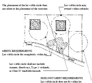
(Ord. 2486; Ord. 1901)
20C.30.25-070 Minimum Lot Frontage.
(1) Purpose. The minimum lot frontage is designed to prevent congestion by allowing for on-site parking and to reduce public nuisances that result from an inability of emergency vehicles to access a building either because vehicles block the access to a residence or because the lot is not wide enough to allow emergency vehicles to enter from the street.
(2) Requirement. Minimum lot frontage is the minimum width of a lot, as defined by the Site Requirements Chart (RCDG 20C.30.25-140), where it shall adjoin a street or approved access corridor. For individual flag lots, lot frontage is measured where the access corridor meets the street. For private streets and access corridors serving less than three lots and accessing directly onto a public street, lot frontage may be reduced to 14 feet. (Ord. 1901)
MINIMUM LOT FRONTAGE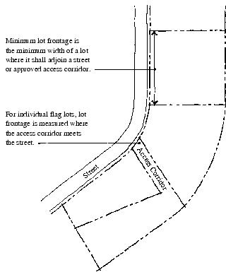
20C.30.25-080 Building Setbacks.
(1) Purpose. Front, rear, side/interior, and side street setbacks help maintain a consistent and compatible land use pattern for Redmond’s residential neighborhoods. Setback requirements also provide for adequate light and air to all properties, minimize incompatibilities such as excessive light and noise, and prevent public nuisances such as the potential for fire damage from buildings constructed too close to each other.
(2) Requirements.
(a) Lot Orientation. For the purpose of applying setback regulations, the following shall be applied: the front shall be toward the street or access corridor from which the lot is addressed; the rear is opposite to the front or as nearly so as the lot shape permits; and the sides are 90 degrees to the front or as nearly so as the lot shape permits.
LOT ORIENTATION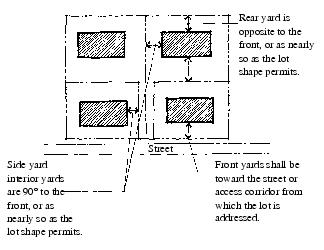
(b) Measurement. All setbacks shall be measured at right angles, or as near to right angles as possible, to the nearest property line in a plane horizontal to the ground, or in the case of access corridors for single-family residential development, from the nearest edge of the easement to the foundation line of the structure. Front, side street, side/interior, and rear directions shall be determined as provided in subsection (2)(a) of this section.
BUILDING SETBACKS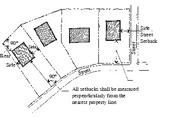
(c) Garage Setbacks. In R-4, R-5, R-6, and R-8 zones, garage doors facing a street or access corridor must be at least 18 feet from the front property line or inside edge of the access corridor or easement.
(d) Side Street Setbacks. Side street setbacks shall apply whenever a side yard adjacent to a structure faces a public street, private street, or access corridor serving more than two lots.
(e) Corner Lots. Corner lots shall be subject to only one front setback requirement.
(f) Side/Interior Setbacks. In those zones where the side/interior setback is five feet and 10 feet, each lot shall have one five-foot side/interior setback and one 10-foot side/interior setback. Where an abutting property has a five-foot side/interior setback, the side/interior setback on that side shall be 10 feet. In no case shall any property be required to have two 10-foot side/interior setbacks. Where both properties abutting a lot have five-foot side/interior setbacks, only one 10-foot side/interior setback shall be required.
(g) Rear Setbacks – Alleys. When vehicular access to a lot is by an alley, the rear setback shall be four feet from the nearest alley line.
(h) Accessory Structure Setbacks. Side interior and rear setbacks (but not side street) for accessory structures in all residential zones are five feet.
(i) Encroachments – Front, Rear, Side Street Setbacks. The following features are permitted to encroach up to three feet into front, rear, and side street setback areas: chimneys, porches, bay windows, other building extremities, and decks. Roof structures which extend beyond the building line may project up to five feet into front, rear, and side street setback areas. No encroachment into a front, rear, or side street setback area may extend closer than two feet to the nearest property line.
(j) Encroachments – Side Interior Setbacks. The following features may encroach up to five feet into side interior setback areas: chimneys, porches, bay windows, roof structures, other building extremities, and decks. No encroachment into a side interior setback area may extend closer than two feet to the nearest property line.
(k) Improvements. Improvements less than 30 inches above grade, including decks, patios, walks and driveways, are permitted in setback areas. Fences, landscaping, flagpoles, street furniture, transit shelters and slope stability structures are permitted in setback areas, provided that all other applicable requirements are met.
PERMITTED ENCROACHMENTS IN SETBACK AREAS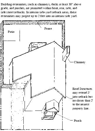
(3) Encroachments/Front, Rear, Side Setbacks. Minor structures, appurtenances and improvements may encroach into required front, rear, and side setbacks as follows:
(a) The following features are permitted to encroach up to three feet into front, rear, and side street setback areas: chimneys, porches, bay windows, other building extremities, and decks. Roof structures which extend beyond the building line may project up to five feet into front, rear, and side street setback areas. No encroachment into a front, rear, or side street setback area may extend closer than two feet to the nearest property line.
(b) Encroachments/Side Interior Setbacks. The following features may encroach up to five feet into side interior setback areas: chimneys, porches, bay windows, roof structures, other building extremities, and decks. No encroachment into a side interior setback area may extend closer than two feet to the nearest property line.
(c) No encroachments are allowed with the Lake Sammamish waterfront building setbacks, except as provided in subsection (5) of this section, Waterfront Building Setbacks along Lake Sammamish. (SMP)
(d) Improvements. Improvements less than 30 inches above grade including decks, patios, walks and driveways are permitted in setback areas. Fences, landscaping, flagpoles, street furniture, transit shelters and slope stability structures are permitted in setback areas, provided that all other applicable requirements are met.
(4) Setback Modifications.
(a) Multi-Family/Front Setbacks. A binding site plan, site plan, or preliminary plat may modify front setbacks along access corridors within multi-family developments, provided that front setbacks are maintained from all public streets.
(b) Zero Lot Line Development. Within zero lot line developments, buildings may be located within the side yard setback according to the requirements set forth in RCDG 20C.30.100.
(5) Waterfront Building Setbacks along Lake Sammamish. (SMP)
(a) Waterfront building setbacks shall be a distance measured from the line of the ordinary high water mark on Lake Sammamish. The ordinary high water mark, as defined in RCDG 20A.20, Definitions, shall be located for each shoreline property through a site reconnaissance and survey by a licensed surveyor.
(b) See RCDG 20D.150.60-020, Lake Sammamish Setback, for setback requirements and restrictions. Habitat enhancement features or shoreline protective structures, subject to the requirements of RCDG 20D.150.80, Shoreline Protective Structures, and in-water structures, subject to the requirements of RCDG 20D.150.70, In-Water Structures, are permitted. Setback vegetation should consist of native trees, shrubs, or groundcover with an emphasis on encouraging a tree canopy.
(c) Parking is prohibited within the waterfront building setback.
(6) Water-Oriented Accessory Structure. (SMP) Water-oriented structures accessory to a shoreline or water-dependent use are permitted in residential zones, provided such structures comply with the special height, setback and area requirements in RCDG 20D.150.70-060, Marinas and Boat Launches.
(7) Building Setbacks from Critical Areas. There are no building setbacks from required critical areas buffers.
(8) Repealed by Ord. 2390. (Ord. 2486; Ord. 2447; Ord. 2390; Ord. 2027; Ord. 1901)
20C.30.25-090 Building Separation.
(1) Purpose. The building separation requirement helps to maintain a consistent and compatible land use pattern for Redmond’s residential neighborhoods. Building separation requirements also provide for adequate light and air to all properties, minimize incompatibilities, such as excessive light and noise, prevent public nuisances such as the potential for fire damage from buildings constructed too close to each other, and allow for easy access to structures in the event of fire or other emergency.
(2) Requirement. Buildings, except for accessory structures, shall maintain the separation required in the Site Requirements Chart, RCDG 20C.30.25-140. (Ord. 1901)
20C.30.25-100 Maximum Lot Coverage for Structures.
(1) Purpose. The maximum lot coverage for structures requirement helps to maintain a consistent and compatible land use pattern for Redmond’s residential neighborhoods. Lot coverage requirements also provide for adequate light and air to all properties, and prevent public nuisances that may result from a reduction of open space, such as increased storm water runoff and other environmental hazards.
(2) Requirement. The maximum lot coverage for structures requirement sets the maximum percentage of a lot that may be covered with primary and accessory structures. Lot coverage percentages for each residential zone are established in the Site Requirements Chart, RCDG 20C.30.25-140. (Ord. 1901)
20C.30.25-110 Maximum Impervious Surface.
(1) Purpose. The maximum impervious surface requirement maintains open space, prevents adverse impacts from storm water runoff, replenishes ground water resources, and minimizes flooding.
(2) Requirement. The maximum impervious surface percentage for each residential zone shown in the Site Requirements Chart (RCDG 20C.30.25-140) establishes the maximum percentage of a lot’s area that may be covered with structures (including outdoor storage), paved areas, and other impervious surfaces.
(3) Modifications. As part of an approved binding site plan or subdivision, the Technical Committee may allow for increased maximum impervious surface limits on individual lots within a multi-lot development provided that the total amount of impervious surface for the development as a whole does not exceed the limit established for that zone in the Site Requirements Chart. If a modification is approved, the development shall be conditioned to ensure compliance with the maximum impervious surface limits set by the Site Requirements Chart. (Ord. 1901)
20C.30.25-120 Minimum Open Space – Landscaping – Buffers.
(1) Purpose. The minimum open space requirement maintains community character by providing visual relief, open space, adequate outdoor space for residents of residential developments, and enhanced public safety by providing adequate off-street recreation space for children.
(2) Requirement. The minimum open space requirement establishes the minimum percentage of a lot or a development that must be set aside as open space, as shown for each residential zone in the Site Requirements Chart, RCDG 20C.30.25-140.
(a) Lot-By-Lot Compliance. Where the minimum open space requirement is met on a lot-by-lot basis, open space shall consist of a contiguous area of natural vegetation, landscaping, or recreation and may include front or backyard areas. No portion of the open space created under this option may have a dimension of less than 15 feet.
(b) Development-Wide Compliance. The minimum open space requirement may be measured on a development-wide basis as opposed to a lot-by-lot basis. Under this option, individual lots may be developed with as little as 10 percent of total lot square footage in open space (as defined in subsection (2)(a) of this section), provided that the development as a whole meets the open space requirement called for in the Site Requirements Chart, RCDG 20C.30.25-140. Common open space created under this modification shall be dedicated and shall:
(i) Serve those lots developed below the open space standard of the Site Requirements Chart;
(ii) Have part of the minimum open space be designed for recreation including picnic areas, children’s play areas, and sports courts;
(iii) Consist of a contiguous area and have no single dimension of less than 25 feet; and
(iv) Have a minimum size equal to the total square foot reduction below the open space standard of the Site Requirements Chart for every lot in the development.
(c) Provisions Applicable to Both Lot-By-Lot and Development-Wide Compliance.
(i) Environmentally sensitive areas, buffers, front and rear lot setbacks, swimming pools, sport courts, recreational buildings, swimming pools, golf courses, sport courts, outdoor patios and similar structures or facilities may be used to meet the minimum open space requirement.
(ii) At least 25 percent of the minimum open space required by RCDG 20C.30.25-140 shall be outside of wetlands, streams, lakes, and sensitive area buffers and on slopes of 10 percent or less and developed and maintained so it is usable for active recreation activities. Playgrounds, recreational buildings, swimming pools, golf courses, sport courts, and similar structures or facilities may be used to meet this requirement.
(iii) No more than 25 percent of the minimum open space required by RCDG 20C.30.25-140 may be located outside the urban growth area or the City of Redmond. The minimum open space shall adjoin the development which is required to provide the space. Easements, dedications, deed restrictions, or similar measures shall permanently limit the use of any open space located outside the urban growth area to open space and recreational uses consistent with a rural area.
(iv) Open space within a development shall be available for common use by the residents, tenants, or, if required by a condition of approval, the general public. Except for the open space required by RCDG 20C.30.25-120(3)(b), the open space may be used for recreation, waterfront access, landscaping, buffers, sensitive area buffers, sensitive areas, or other open space and recreational uses the City may approve during project review and approval. The open space required by RCDG 20C.30.25-120(3)(b) may be used for recreation and open space uses. Sensitive area buffers and sensitive areas shall not be used for recreation unless the use is specifically approved by the Administrator.
(3) Repealed by Ord. 2390. (Ord. 2390; Ord. 2027; Ord. 1901)
20C.30.25-130 Maximum Height of Structures.
(1) Purpose. The maximum height of structures helps to maintain a consistent land use pattern and visual character in residential neighborhoods. It may also serve to protect important community-recognized view corridors. Shoreline height limits protect habitat values and the aesthetic resources of the shoreline and aid in preserving views in shoreline areas.
(2) Requirements. The maximum height of structures requirement sets the limit above which structures shall not extend, as defined in the Site Requirements Chart (RCDG 20C.30.25-140) for each residential zone.
(a) Chimneys, antennas, smoke and ventilation stacks, and flagpoles may exceed the highest point of the existing or proposed structure by no more than 15 feet.
(b) Religious Icons and Structures. Special height exceptions for steeples, bell towers, crosses or other symbolic religious icons are contained in RCDG 20D.170.40.030.
(3) Maximum Height of Structures – Height Limits Within Shorelines. (SMP) Within the shoreline jurisdiction, the following height limits apply:
(a) The maximum height of all structures, except water-oriented accessory structures and piers or docks, shall be 30 feet.
(b) Water-oriented accessory structures shall not exceed 10 feet in height.
(c) The maximum height of docks is specified in RCDG 20D.150.70, In-Water Structures.
(d) The maximum height of structures, including bridges, that support a regional light rail transit system may be higher than 30 feet but shall be no higher than is reasonably necessary to address the engineering, operational, environmental, and regulatory issues at the location of the structure. (Ord. 2486; Ord. 1954; Ord. 1901)
20C.30.25-135 Maximum Height of Structures in a Transition Overlay.
Repealed by Ord. 2390. (Ord. 2027)
20C.30.25-140 Site Requirements Chart and Flexibility.
The Site Requirements Chart, RCDG 20C.30.25-140, establishes the basic dimensional requirements for residential development in each residential zone of the City. Flexibility from these requirements may be obtained through a number of residential development processes:
(1) The Green Building and Green Infrastructure Incentive Program allows for some flexibility in setbacks, unit types, and density, all toward the end of encouraging green building and natural stormwater management (see RCDG 20C.30.57);
(2) Zero Lot Line Development allows for some modification to the setback standards defined in the chart (see RCDG 20C.30.100);
(3) Multiplex requirements define special lot size dimensions and other requirements (see RCDG 20C.30.70).
|
Site Requirement |
Zoning Districts |
Residential Innovative |
|||||||||||
|
RA-5 |
R-1 |
R-2 |
R-3 |
R-4 |
R-5 |
R-6 |
R-8 |
R-12 |
R-18 |
R-20 |
R-30 |
RIN |
|
|
Allowed Density (dwelling units per gross acre) |
0.2 |
1 |
2 |
3 |
4 |
5 |
6 |
8 |
12 |
18 |
20 |
30 |
16 |
|
Minimum Required Density (percent of net acres) |
80% |
80% |
80% |
80% |
80% |
80% |
80% |
75% |
75% |
65% |
65% |
65% |
80% |
|
Average Lot Size |
4.5 acres1 |
35,000 sq. ft.1,2 |
18,000 sq. ft. |
12,000 sq. ft. |
7,000 sq. ft. |
5,500 sq. ft. |
4,000 sq. ft. |
3,000 sq. ft. |
3,000 sq. ft. |
2,500 sq. ft. |
NS |
NS |
17 |
|
Minimum Lot Width Circle (in feet)3 |
100' |
85' |
70' |
60' |
40' |
35' |
35' |
30' |
30' |
NS |
NS |
NS |
17 |
|
Minimum Lot Frontage (in feet)4 |
20' |
20' |
20' |
20' |
20' |
20' |
20' |
20' |
20' |
20' |
30' |
30' |
20' |
|
Front Setback (in feet)19 |
30' |
30' |
30' |
20' |
15'5 |
15'5 |
15'5 |
10'5 |
10' |
10' |
20' |
20' |
15' |
|
Side/Interior Setback (each side) (in feet)6, 19 |
30' |
20' |
5'/10' |
5'/10' |
5'/10' |
5'/10' |
5'/10' |
5' |
5'7 |
5' |
15'8 |
15' |
5'/10' |
|
Side Street Setback (in feet)19 |
20' |
20' |
15' |
15' |
15' |
15' |
15' |
10' |
10' |
15' |
15' |
15' |
15' |
|
Rear Setback (in feet)9, 19 |
30' |
30' |
10' |
10' |
10' |
10' |
10' |
10' |
10' |
10' |
10' |
10' |
10' |
|
Lake Sammamish Setback10, 19 (SMP) |
35' |
35' |
35' |
35' |
35' |
35' |
35' |
35' |
35' |
35' |
35' |
35' |
35' |
|
Minimum Building Separation (in feet)11 |
10' |
10' |
10' |
10' |
10' |
10' |
10' |
10' |
10'12 |
15'13 |
15'13 |
15' |
10'18 |
|
Maximum Lot Coverage for Structures |
2.5% |
12% |
30% |
35% |
35% |
40% |
45% |
50% |
55% |
60% |
60% |
60% |
17, 18 |
|
Maximum Impervious Surface Area |
20% |
20% |
40% |
60% |
60% |
60% |
65% |
70% |
70% |
75% |
75% |
80% |
17 |
|
Minimum Open Space14, 19 |
NS |
NS |
NS |
20% |
20% |
20% |
20% |
20% |
20% |
20% |
20% |
20% |
20% |
|
Maximum Height |
35' |
35' |
35' |
35' |
35' |
35' |
35' |
35' |
45' |
45' |
60' |
60' |
25' |
|
Maximum Height within Shorelines 19, 20(SMP) |
30' |
30' |
30' |
30' |
30' |
30' |
30' |
30' |
30' |
30' |
30' |
30' |
30' |
Notes:
1 Within the RA-5 and R-1 zones, at least 1,000 square feet of contiguous open space in a buildable shape, and free of all hazards, together with access to the residential unit must be identified for each lot (see RCDG 20C.30.25-050(2), Average Lot Size).
2 Lot clustering is required in R-1 zones in areas where more than 60 percent of the site is subject to natural limitations or hazards and the creation of more than one lot is proposed.
3 The Minimum Lot Width Circle for the area south of Idylwood Beach Park between Lake Sammamish and West Lake Sammamish Parkway shall be 30 feet.
4 For private streets and access corridors serving less than three lots and accessing directly onto a public street, lot frontage may be reduced to 14 feet.
5 To ensure that streets, sidewalks, and access corridors are not blocked by cars parked in driveways, at least 18 feet of driveway shall be provided between the garage, carport, or other fenced parking area and the street property line, except when alleys are used for vehicular access. See RCDG 20C.30.25-080(2)(c), Garage Setbacks.
6 Side/Interior Setbacks for accessory structures are five feet for all residential zones. Side/Interior Setbacks are not required for one side yard of a Zero Lot Line Development (see RCDG 20C.30.100, Zero Lot Line Development, Building Setbacks).
7 For detached single-family dwellings, the Side/Interior Setback shall be three feet.
8 This Side/Interior Setback standard applies to all types of attached housing development. For detached single-family dwellings, the standard is 5/5 feet.
9 The rear setback for accessory structures is five feet for all residential zones. The rear setback for alleys is four feet from the nearest alley line.
10 See RCDG 20D.150.60-020, Lake Sammamish Setback, for setback requirements and restrictions. (SMP)
11 The Minimum Building Separation does not apply to accessory structures.
12 The Minimum Building Separation requirement for single-family detached housing shall be six feet. For all forms of stacked housing, the minimum building separation shall be 20 feet.
13 The Minimum Building Separation requirement for single-family detached housing shall be six feet. For multiplex housing, the Minimum Building Separation shall be 10 feet.
14 The Minimum Open Space requirement may be applied on a lot-by-lot basis or on a sitewide basis as described in RCDG 20C.30.25-120, Minimum Open Space.
15 The Maximum Height of Structures in shoreline areas, including areas between Lake Sammamish and West Lake Sammamish Parkway, and within the “Wedge” subarea of the North Redmond neighborhood, shall be 30 feet.
16 See RCDG 20C.30.82-030, Residential Innovative Zone, Density.
17 See RCDG 20C.30.82-050, Residential Innovative Zone, Other Site Requirements.
18 See RCDG 20C.30.82-050 and 20C.30.82-070, requirements for Willows/Rose Hill.
19 See Chapter 20D.230 RCDG, Transition Overlay Areas, for regulations specific to properties in a Transition Overlay.
20 Building height in the shoreline jurisdiction is measured from average existing grade (SMP). See also RCDG 20C.30.25-130(3) for maximum height of structures within shorelines.
(Ord. 2486; Ord. 2463; Ord. 2447; Ord. 2390; Ord. 2126; Editorially amended during 12/02 supplement; Ord. 1901)