


Chapter 20.70
AIRPORT OVERLAY ZONES AND REGULATIONS
Sections:
20.70.050 Airport overlay zone maps.
20.70.060 Density and intensity limitations for new development.
20.70.070 Airspace protection areas—Height limitations.
20.70.090 Nonconforming conditions.
20.70.010 Title.
The regulations codified in this chapter shall be known and may be cited as the “airport overlay zone regulations.” (Ord. 1698-0407 § 1 (part), 2007)
20.70.020 Purpose and intent.
A. Purpose. The airport overlay zone regulations have two fundamental purposes:
1. To minimize the public’s exposure to excessive noise and safety hazards that would result from incompatible land use development around Sanderson Field; and
2. To protect Sanderson Field from potential encroachment by land uses that are incompatible with airport activities and that may impair the planned development and use of the airport.
B. Intent. The intent of this chapter is to:
1. Implement policies of the city of Shelton’s comprehensive plan and the Port of Shelton, Sanderson Field Airport Master Plan.
2. Establish land use zoning regulations around Sanderson Field that are specifically designed to address issues of compatibility between the airport and surrounding land uses. Regulations are established with respect to compatible land use, noise, safety, and height limits (airspace protection). (Ord. 1698-0407 § 1 (part), 2007)
20.70.030 Applicability.
A. Affected Land Use Activities and Structures—General Applicability.
1. This chapter applies to the following activities and structures situated within the airport overlay zone established as the land use compatibility zones (Map 1) and the airspace protection areas (Map 2):
a. Land divisions.
b. New construction.
c. Changes to existing structures or site improvements, or to the uses of land or structures, to the extent that such changes require review under other applicable regulations.
B. Aviation Uses and Structures Not Affected. This chapter does not apply to:
1. Aviation and related development or use of airport property for aeronautical purposes.
2. The manner in which aircraft operate on the airport or in the surrounding airspace.
C. Uses and Structures Not Affected. This chapter does not apply to:
1. Existing development as of the effective date of this chapter for which no expansion or changes in use are proposed even if the existing uses are not in conformance with the standards herein. (Ord. 1698-0407 § 1 (part), 2007)
20.70.040 Definitions.
The following definitions apply for the purposes of this chapter:
A. “Airport” means Sanderson Field airport in Mason County. This includes but is not limited to the terminal, fixed-base operations, and the area of land designated and set aside for the landing and taking off of aircraft, including all necessary taxiways, aircraft storage and tie-down areas, hangars, and other necessary buildings, and open spaces designated for the storage, repair, and operation of aircraft, and utilized or to be utilized in the interest of the public for such purposes.
B. “Airport manager” means the Port of Shelton board of commissioners or another person delegated to represent the board for the purposes established in this chapter.
C. “Federal Aviation Regulations (FAR) Part 77” means that part of federal regulations dealing with obstructions to air navigation.
D. “Temporary special events” are ones (such as festivals, balloon fairs or an air show at an airport) for which a facility is not designed and normally not used and for which extra safety precautions can be taken as appropriate.
E. “Gross density” means the number of dwelling units, including detached secondary units, on a specific parcel, site, or land use development divided by the gross acreage of the parcel, site, or development.
F. “Special function land use” means land use for which the significant common element is the relative inability of the people occupying the space to move out of harm’s way; this includes schools (K—12), hospitals, nursing homes, day care centers, and other similar uses involving occupants that require personal assistance in vacating the premises.
G. “Structure” in the context of this chapter means an object, including a mobile object, constructed or installed by man, including, but without limitation, buildings, antennas, towers, cranes, smokestacks, and overhead transmission lines.
H. “Usage intensity” is the number of people occupying a specific parcel, site, or land use development divided by the gross acreage of the parcel, site, or development. Usage intensity criteria are applicable to all types of land uses except residential. (Ord. 1698-0407 § 1 (part), 2007)
20.70.050 Airport overlay zone maps.
The area of the airport overlay zone is defined by two maps as established below.
A. Land Use Compatibility Zones (Map 1).
1. The land use compatibility zones map depicts the boundaries of the Sanderson Airfield influence area and airport land use zones for which various compatibility criteria are defined in this chapter. The land use compatibility zone boundaries take into account incompatible land use activity, relative risks of aircraft accidents in various portions of the airport environs, noise and other associated activities that may impact the operations of the airport in the future.
2. Specific factors upon which the boundaries of the land use compatibility zones are delineated are as follows:
a. Zone 1—Runway Protection Zone (RPZ). This zone is trapezoidal in shape and centered about the extended runway centerline. It begins two hundred feet beyond the end of the area usable for takeoff or landing. The RPZ dimensions are a function of the type of aircraft operating at the airport and the approach visibility minimums associated with each runway end.
b. Zone 2—Inner Safety Zone (ISZ). This encompasses a rectangular area that is positioned on the extended runway centerline, and adjacent to the RPZ boundary. For Runway 5-23, as shown on Map 1, zone 2, extends approximately two thousand three hundred feet beyond the RPZ boundary.
c. Zone 3—Inner Turning Zone (ITZ). The ITZ boundary is defined by a triangular-shaped area that is positioned along each side of the RPZ and ISZ boundaries. For Runway 5-23, the ITZ extends approximately four thousand five hundred feet from the inner width of the RPZ, within a sixty-degree sector of the extended runway centerline.
d. Zone 4—Outer Safety Zone (OSZ). The OSZ is a rectangular area that is also centered on the runway. For Runway 5-23, the OSZ is one thousand feet wide overall (extending five hundred feet laterally from the runway centerline) and extends approximately three thousand feet beyond the ISZ.
e. Zone 5—Sideline Safety Zone (SSZ). For Runway 5-23, the SSZ boundary is defined by a one-thousand-foot centerline offset on each side of the runway that connects the ITZs on each end of the runway.
f. Zone 6—Traffic Pattern Zone (TPZ). This encompasses an area surrounding the runway of approximately five thousand feet, as depicted in airport land use zoning map.
B. Airspace Protection Areas (Map 2). The airspace protection areas map depicts the airspace surfaces defined for Sanderson Field in accordance with Federal Aviation Regulations, Part 77, Subpart C. For the purposes of this chapter, planned future runway configuration or types of runway approaches are assumed in the airspace protection areas. The critical airspace surfaces are defined by a set of five types of surfaces as follows:
1. A primary surface is longitudinally centered and extends two hundred feet beyond each end of the runway. The width is one thousand feet for Runway 5-23. The elevation of any point on the primary surface is the same as the elevation of the nearest point on the runway centerline.
2. Approach surfaces are longitudinally centered on the extended runway centerline and extend outward and upward beginning at, and at the same elevation as, each end of a primary surface. Approach surface dimensions and slopes for each runway end are as follows:
a. Runway 23:
i. Inner edge width: one thousand feet.
ii. Outer end width: sixteen thousand feet.
iii. Length: fifty thousand feet.
iv. Slope: fifty to one (one foot vertically for each fifty feet horizontally) for the inner ten thousand feet of length and forty to one for the outer forty thousand feet.
b. Runway 5:
i. Inner edge width: one thousand feet.
ii. Outer edge width: four thousand feet.
iii. Length: ten thousand feet.
iv. Slope: twenty to one.
3. Transitional surfaces extend outward from the sides of each primary surface and each approach surface. These surfaces slope upward one foot vertically for each seven feet horizontally, measured at a ninety-degree angle to the runway centerline and extended runway centerline, and continue to where they intersect a horizontal or conical surface. For those portions of a precision approach surface which extend through or beyond the limits of the conical surface, the adjacent transitional surfaces extend a distance of five thousand feet horizontally from the edge of the approach surface, measured at a ninety-degree angle to the extended runway centerline.
4. A horizontal surface is established at an elevation of two hundred fifty-four feet above the highest point on airport Runway 5, and two hundred sixty-nine feet above the highest point on airport Runway 23, specifically four hundred nineteen feet above mean sea level. The inner edge of the horizontal surface is defined by its intersection with transitional surfaces. The outer edge is defined by drawing arcs with radii of ten thousand feet centered on the runway centerline at each end of the primary surface of Runway 9-27, then connecting the arcs with lines drawn tangent to them.
5. A conical surface extends outward for a distance of four thousand feet from the periphery of the horizontal surface and upward at a slope of one foot vertically for each twenty feet horizontally.
Land Use Compatibility Zones (Map 1)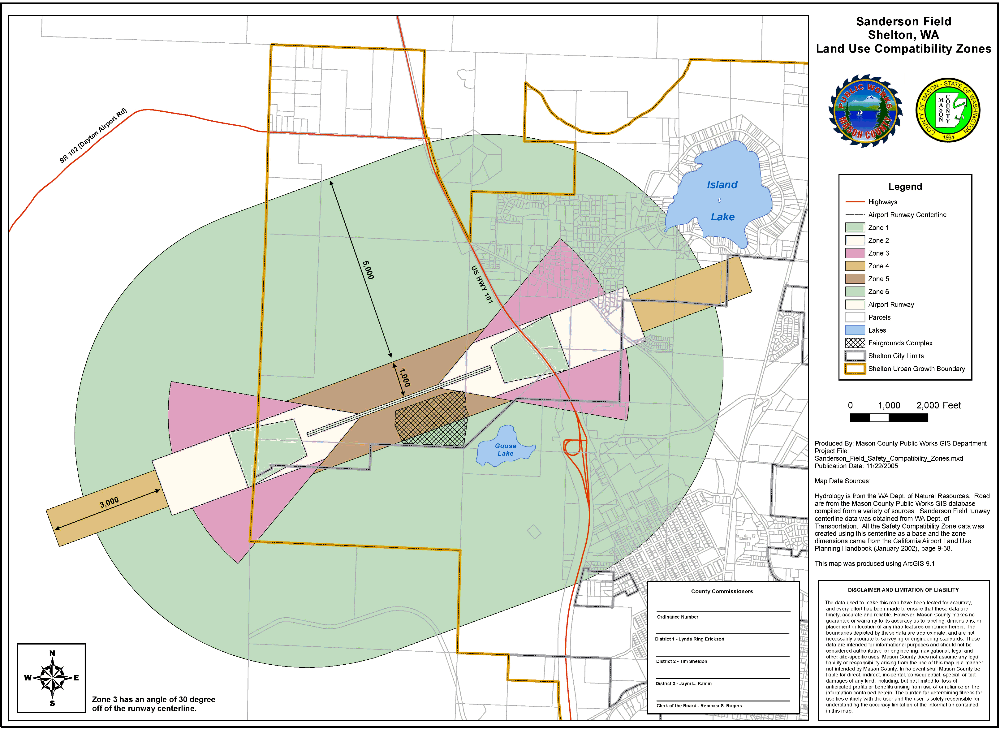
Airspace Protection Areas (Map 2)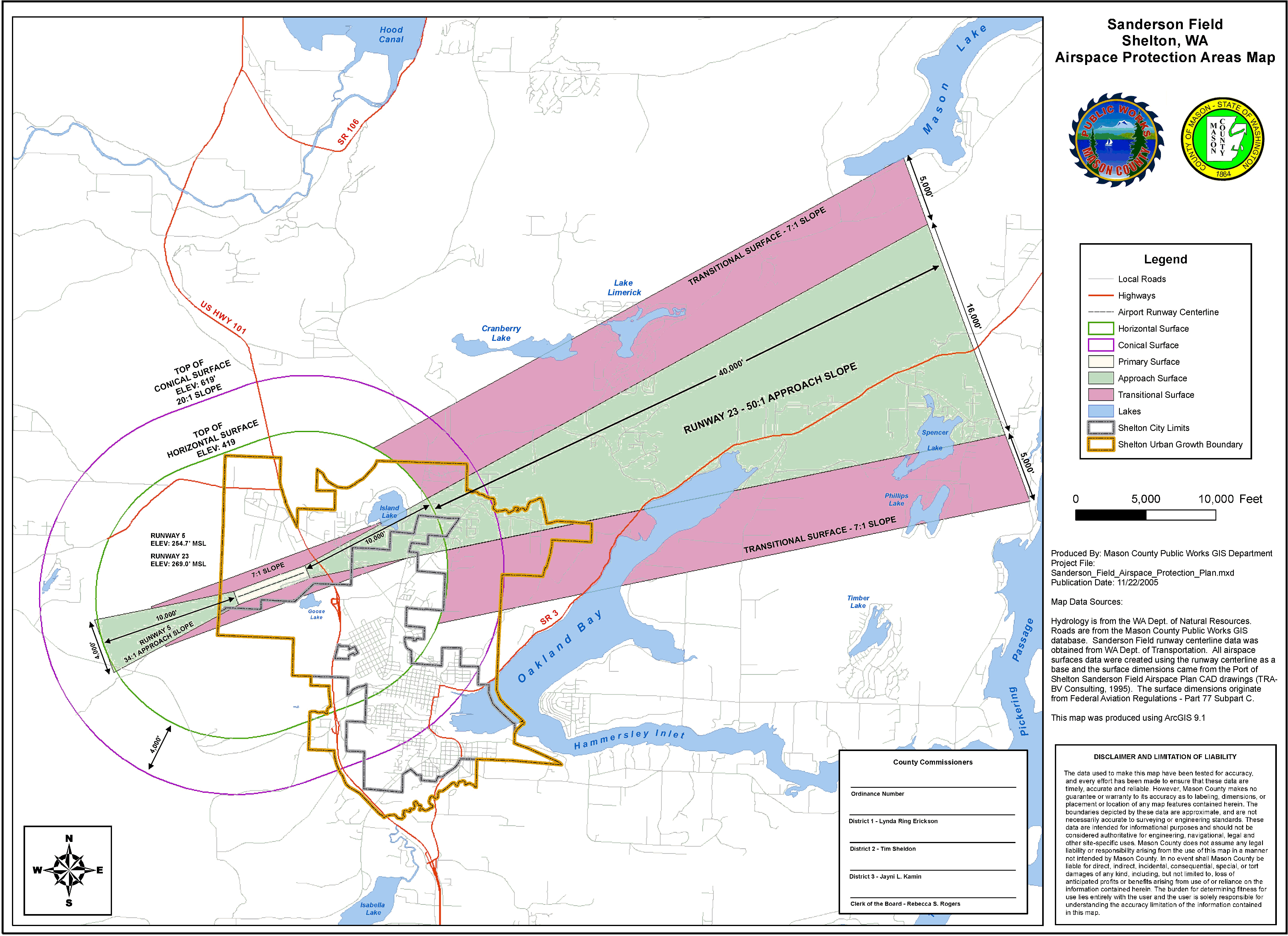
(Ord. 1698-0407 § 1 (part), 2007)
20.70.060 Density and intensity limitations for new development.
A. Residential Development Density Criteria. Any subdivision of property for the purposes of residential development within the land use compatibility zones shall comply with the following density criteria:
1. Land Use Compatibility Zones 1, 2 and 5. No new residential land divisions are permitted. No new residential dwellings permitted.
2. Land Use Compatibility Zones 3 and 4. No multifamily, except as permitted in subsection B of this section. Residential land divisions for single-family development are limited to one dwelling unit per five acres. Residential development must comply with usage intensity (this section) and deed notification (Section 20.70.080) requirements. Infill development is allowed as provided in subsection H of this section.
B. Mixed Use Development. If residential uses are proposed to be located with nonresidential uses in the same or nearby buildings on the same site, they shall be treated as nonresidential development provided the residential development does not exceed thirty percent of the overall square footage of the structures. The occupancy of the residential portion shall be added to that of the nonresidential portion and evaluated with respect to the nonresidential usage intensity criteria defined in subsection D of this section.
C. Special Function Land Use. Special function land uses as defined in 20.70.040(F) shall be prohibited in the land use compatibility zones 1, 2, 3, and 4. New special function land uses are also prohibited in zone 6; however, expansion of such existing uses are conditioned upon review for impacts to the airport through the special use permit provisions of Chapter 20.46, with added performance standards addressing potential noise impacts.
D. Nonresidential Development Usage Intensity Criteria. Any proposed nonresidential construction or use of land within the land use compatibility zones shall not be permitted if they exceed the following usage intensity limitations.
1. Zone 1. No people other than aircraft occupants, airport personnel, and other persons authorized by airport regulations.
2. Zone 2. No more than five people per acre average over the site.
3. Zone 3. No more than twenty-five people per acre average over the site.
4. Zone 4. No more than four people per acre in buildings and no more than seventy-five people per acre outside of buildings.
5. Zone 5. No more than one hundred people per acre average over the site.
E. Usage Intensity Calculation Factors. The maximum number of people permitted on a site within the land use compatibility zones shall be calculated based on the following factors:
1. All people (e.g., employees, customers, visitors, etc.) who may be on the property are to be included in the calculations.
2. The calculations must reflect the total number of people on the site at any time, except temporary special events.
3. All usage intensities are calculated on a gross acreage basis including streets within a site, half-streets abutting a site, and permanently open lands.
4. Intensity on the property under review shall be calculated for each acre of the site by a site plan identifying each one acre area and the respective use and density. The one-acre areas indicated are to be generally square or rectangular in shape; provided, that rectangles shall be no longer than twice their width. To the extent that the parcel is irregularly shaped, the site plan shall show the best fit of the one acre or portion of one acre areas consistent with the intent of this chapter.
F. Usage Intensity Data Sources. The usage intensity of all individual uses highly depends upon the specifics of the proposed land use and its design. Where necessary to determine the acceptability of a particular proposal within the land use compatibility zones, the anticipated number of people per acre can be calculated based upon any of the following methods:
1. The Number of Automobile Parking Spaces Required on the Site. Unless a substantial number of people would arrive at the site by means other than automobile (or would park off-site), the anticipated number of people on the site can be estimated to be at least equal to the number of automobile parking spaces required for the use. A higher number shall be assumed for uses that typically attract more than one person per vehicle.
2. International Building Code (IBC) Occupancy Levels. The anticipated maximum number of people occupying indoor facilities on a site can be assumed to be no higher than the total floor area of the proposed use divided by the minimum square feet per occupant requirements listed in the IBC. Because the IBC criteria represent highly intensive levels of usage, the number obtained through this calculation can normally be divided in half for the purposes of the usage intensity criteria in this section.
3. Documented Survey or Analysis Results. A project applicant may provide evidence, such as surveys of existing uses similar to the type proposed, documenting that specific features of a proposal would result in a usage intensity lower than that assumed using the methods indicated above. Acceptance of such evidence shall be at the discretion of city of Shelton community and economic development director.
G. Parcels Lying within Two or More Land Use Compatibility Zones. If a parcel proposed for residential subdivision is split by land use compatibility zone boundaries, the total number of dwelling units permitted shall be calculated as if the parcel were multiple parcels divided at the compatibility zone boundary line. Similarly, if a parcel proposed for nonresidential use is split by compatibility zone boundaries, the usage intensity shall be calculated as if the parcel were divided at the compatibility zone boundary line. In both cases, however, the development density or intensity allowed within the more restricted portion of the parcel can (and is encouraged to) be transferred to (clustered on) the less restricted portion even if the resulting development in the latter area then exceeds the criteria for that compatibility zone. This transfer of development is also allowed with respect to multiple parcels proposed to be developed as a single project.
H. Infill Development. Where development not in compliance with this chapter already exists adjacent to the site of the proposal, additional infill development of similar or less intensive land uses may be allowed to occur even if such land uses are not allowed elsewhere in the land use compatibility zones. This exception does not apply within land use compatibility zone 1. A parcel can be considered for infill development if it meets all of the following criteria:
1. The parcel size is no larger than two acres.
2. The site is at least sixty-five percent bounded (excluding roads) by existing uses similar to, or more intensive than, those proposed.
3. The proposed project would not extend the perimeter of the area defined by the surrounding, already developed, incompatible uses.
4. In the case of a nonresidential use, the proposed project would not have a usage intensity more than fifty percent above the intensity permitted in accordance with subsection D of this section.
5. The proposed project will not otherwise increase the intensity and/or incompatibility of use through special use permits, density transfers, or subdivisions.
6. The proposed project complies with all other land use and development regulations applicable in the underlying zone. (Ord. 1698-0407 § 1 (part), 2007)
20.70.070 Airspace protection areas—Height limitations.
A. Basis for Height Limits. Protection of navigable airspace from obstructions that can be hazards to aircraft flight requires establishment of limits on the height of structures, trees, and other objects in the vicinity of Sanderson. These limits are primarily based upon Part 77, Subpart C, of the Federal Aviation Regulations (FAR), but also may take into account the United States Standard for Terminal Instrument Procedures (TERPS) and applicable airport design standards published by the Federal Aviation Administration.
B. Criteria.
1. No structure shall penetrate or be permitted to have a height exceeding that of the critical airspace surfaces defined on Map 2 of Section 20.70.050(B), except as specifically necessary for airport operations.
2. Variance procedure height adjustments from the height limit criteria may be permitted subject to the variance criteria of Chapter 20.50 and only if all of the following conditions are met:
a. There is located another existing object or obstruction (terrain, trees, buildings or other structures of greater height) within a two-hundred-foot radius of the proposed object.
b. The owner of the property agrees to take responsibility for ensuring that any obstruction marking and/or lighting required by the Federal Aviation Administration is installed, operated, and maintained, unless the airport manager has agreed in writing to be responsible for such installation, operation, and maintenance.
c. The Federal Aviation Administration has conducted an aeronautical study of the proposed object and determined that the object would not create a hazard to the navigable airspace of the airport.
C. Notification to Federal Aviation Administration. Nothing in this chapter shall diminish the responsibility of project proponents to submit a notice of construction or alteration to the Federal Aviation Administration if required in accordance with Subpart B of Federal Aviation Regulations Part 77, “Objects Affecting Navigable Airspace.” (Ord. 1698-0407 § 1 (part), 2007)
20.70.080 Other requirements.
A. Deed Notification.
1. As a condition for approval of new development within the approach surfaces (Section 20.70.050(B)(2)) shown on the airspace protection areas map (Map 2), or land use compatibility zones 2, 3, 4, 5, and 6 (Map 1); a notice shall be recorded with the county auditor prior to final approval of new subdivisions, short subdivisions, building permits, conditional use permits, special use permit or other similar permits, unless said notice is already recorded on the property. Said notice shall state: “This property is located adjacent to an airport and routinely subject to overflight activity by aircraft using the airport. Residents and tenants may experience inconvenience, annoyance, or discomfort from noise, smell or other effects of aviation activities.” (Ord. 1698-0407 § 1 (part), 2007)
20.70.090 Nonconforming conditions.
Land uses and structures not in conformance with this chapter shall be regulated under the provisions of Chapter 20.42. (Ord. 1698-0407 § 1 (part), 2007)
20.70.100 Review procedures.
A. Applications for land uses or land use development within the airport overlay zone shall include the following information:
1. Property boundaries and acreage of the project/proposed use, including the geographic relationship to the land use compatibility and airspace protections zones.
2. Location, elevation, and height of all existing and proposed buildings, structures, and utility lines. The applicant may also be asked for the location, elevation, and height of trees.
3. A description of the proposed land use including the number of dwelling units and/or number of people expected to occupy the site.
B. In consideration of an application for a building, structure, or other use, the reviewing official may require the applicant to submit a certificate from a registered professional engineer or a licensed land surveyor clearly indicating the average ground elevation, maximum elevations of proposed structure(s) and the critical airspace surfaces based on the established airport elevation and USGS datum. The registered professional engineer or a licensed land surveyor shall determine elevations plus or minus one foot shown as mean sea level (msl) elevation and maximum elevation above the airport runway elevation.
C. When requested the application shall also include the analysis of the proposal with respect to the density and intensity limitations contained in Section 20.70.060.
D. Review Criteria.
1. In reviewing such proposals, the Shelton community and economic development department shall consider the following factors:
a. The compatibility criteria adopted by the county;
b. Characteristics of the proposed land use development.
The county shall consult with the airport manager, and should consider consulting with the Washington Department of Transportation, Aviation Division, before making a determination.
2. The review of variances from height limits under Section 20.70.070 shall be considered a Type II administrative variance. (Ord. 1698-0407 § 1 (part), 2007)