


Chapter 17.18B
OBR DISTRICT II
Sections:
17.18B.030 Lot, density and yard requirements.
17.18B.040 Height and parking.
17.18B.060 Maximum height limits.
17.18B.080 Manufactured storage containers.
17.18B.010 Purpose.
The Ocean Beach residential II district is intended to provide for the residential development of the certain area outside the urban shoreline area regulated by the Shoreline Management Act, Chapter 90.58 RCW, while protecting the resources and attributes which give this area its unique qualities. Special use, minimum lot size, height, and setback requirements are incorporated into this district to provide this protection.
Because of the unique qualities of the area, this district shall only apply to those certain areas designated on the zoning map. (Ord. 1362 § 2, 2005)
17.18B.020 Permitted uses.
The following uses shall be permitted in the OBR district II, subject to the provisions of this chapter and the applicable requirements of this title:
(1) Site-built, new-designated manufactured or modular single-family dwellings, detached dwellings, duplexes, home occupations, parks, playgrounds, beach accesses, family day care providers, adult family homes, and those public utilities necessary to serve the development within this zoning district.
(2) Townhouses approved through the planned development process provisions of WMC 17.36.110 through 17.36.130. Minimum lots for townhouses may be 1,500 square feet, and 2,400 square feet average lot size. Townhouse developments shall provide buffers and not less than 25-foot setbacks from lots developed with single-family houses.
(3) Prohibited Uses. Any use not listed in this section as an allowable use is deemed a prohibited use. (Ord. 1578 § 4, 2015; Ord. 1464 § 3, 2010; Ord. 1362 § 2, 2005)
17.18B.030 Lot, density and yard requirements.
(1) Minimum lot size: 7,500 square feet.
(2) Maximum density: Six units per acre.
(3) Minimum yards: Front and rear yards shall be no less than 20 feet. Side yards shall be no less than five feet. Within the OBR district II, side yards shall be measured at right angles to the side lot line and shall extend into the lot to the point on the building closest to the lot line. The provisions of WMC 17.36.160 shall not apply to required side yards within the OBR district II, notwithstanding the provisions of WMC 17.36.020 through 17.36.130. (Ord. 1362 § 2, 2005)
17.18B.040 Height and parking.
(1) Maximum height: two stories and not more than 30 feet. Accessory buildings shall not exceed one story or 15 feet in height.
(2) Measurement of maximum height: See WMC 17.18A.080.
(3) Parking requirements: See WMC 17.36.260.
(4) Access requirements: See WMC 17.36.260. (Ord. 1362 § 2, 2005)
17.18B.050 Outdoor storage.
(1) Building materials, equipment and appliances, fishing equipment, and similar items shall not be stored outdoors or outside of a building.
(2) Recreational vehicles, campers, trailers, and boats may be stored outdoors provided they shall not be stored within the required front yard. Recreational vehicles, campers, trailers, and boats shall not be stored or parked within five feet of a side lot line. (Ord. 1362 § 2, 2005)
17.18B.060 Maximum height limits.
Maximum height limits and the method of measuring height for the areas west of Surf Street and south of Ocean Avenue:
(1) Maximum Height. The maximum height of any building or structure shall not exceed a total maximum height of 30 feet. Accessory buildings and structures shall not exceed a maximum height of 15 feet. This requirement applies to all areas described in this section, notwithstanding any provision of the zoning district within which the property is located.
(2) Measurement of Maximum Height. All building and structure heights shall be measured as set out in the following definitions and Figures 17.18B(1) and (2). The maximum building height permitted shall be determined based on these definitions and Figures 17.18B(1) and (2). The definitions of “building height” and “grade” in WMC 17.08.020, Definitions, shall not apply to the OBR II zone east of Surf Street and south of Ocean Avenue.
(A) “Average finished grade level” means the average of the topography of the portion of the lot, parcel, or tract of real property which will be directly under the proposed building or structure as the topography will exist after the building or structure is constructed and the property filled, graded, and/or excavated, and landscaped; provided, that in the case of structures to be built over water, average grade level shall be the elevation of ordinary high water. Calculation of the average grade level shall be made by averaging the elevations at the center of all exterior walls of the proposed building or structure. (See Figure 17.18B(1)).
(B) “Average natural grade level” means the average of the natural or existing topography of the portion of the lot, parcel or tract of real property which will be directly under the proposed building or structure; provided, that in the case of structures to be built over water, average grade level shall be the elevation of ordinary high water. Calculation of the average grade level shall be made by averaging the elevations at the center of all exterior walls of the proposed building or structure. (See Figure 17.18B(1)).
(C) “Height” means the maximum vertical dimension of a structure, which for the purposes of this section shall be the greater of the two vertical dimensions obtained by the following methods of measuring height:
(i) Method A: The vertical distance measured from the average natural grade level to the highest ledge or coping on a mansard or flat roof, or the highest ridge of a pitch, shed, or hip roof. (See Figure 17.18B(2)).
(ii) Method B: The vertical distance measured from the average finished grade level to the highest edge or coping on a mansard or flat roof, or the highest ridge of a pitch, shed or hip roof. (See Figure 17.18B(2)). (Ord. 1448 § 1, 2008; Ord. 1362 § 2, 2005)
FIGURE 17.18B(1): GRADE CALCULATION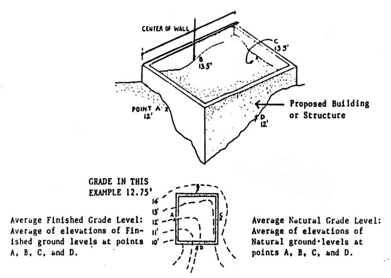
FIGURE 17.18B(2): MEASURING MAXIMUM HEIGHT OF BUILDING OR STRUCTURES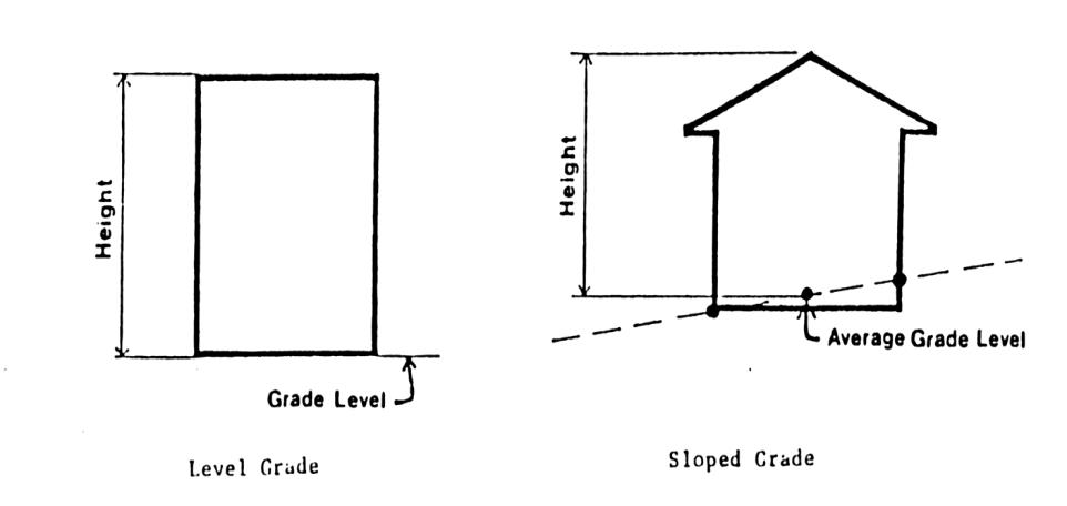
17.18B.070 Navigation aids.
No building or structure shall be constructed which would, in the judgment of the U.S. Coast Guard, interfere with any navigation or shipping aids. (Ord. 1362 § 2, 2005)
17.18B.080 Manufactured storage containers.
The use of manufactured storage containers for any use, including accessory uses, is prohibited. (Ord. 1467 § 4, 2010)