


Chapter 15.05
SITE DESIGN AND IMPROVEMENT STANDARDS
Sections:
15.05.020 Site design requirements and standards.
15.05.030 Creation of new lots—Subdivision requirements.
15.05.050 Street right-of-way dedication.
15.05.055 New development improvement standards.
15.05.010 Purpose.
The purpose of this section is to establish certain basic development requirements. These are the minimum criteria that must be met to assure land use compatibility and promote the public health, safety and welfare. Some of these requirements are flexible and the administrative official or hearing examiner may adjust them under YMC Chapter 15.10. (Ord. 2016-029 § 1 (Exh. A) (part), 2016: Ord. 2008-46 § 1 (part), 2008: Ord. 2947 § 1 (part), 1986).
15.05.020 Site design requirements and standards.
A. Table of Site Design Standards and Subdivision Requirements. The provisions of this chapter and the requirements in Tables 5-1 and 5-2 are established for all development in the zoning districts indicated.
B. Development on Nonconforming Lots. Development on nonconforming lots is governed by this section and YMC 15.19.040. Except as limited by this title, any permitted use may be allowed on any lot legally created prior to the adoption of this title. Such development and structures are subject to the following additional provisions:
1. Detached single-family dwellings erected on nonconforming lots must meet the following criteria:
a. The setback dimensions of the structure conform to the regulations of this title;
b. The lot has at least twenty feet of frontage on, or a minimum twenty-foot-wide access easement to, a public or private road;
c. All other site design and development criteria other than the lot size requirements of Table 5-2 are met.
2. Zero lot line, common wall, or duplex development may be permitted on such lots in the R-2, R-3 and B-1 districts only if the conditions of subsection (B)(1) of this section are met.
3. Multifamily development may be permitted in the R-2, R-3, B-1, CBD and GC districts only if the criteria of subsection (B)(1) of this section are met.
4. Zero lot line, common wall, duplex or multifamily development is not allowed on such lots in the SR and R-1 zones unless such development is the replacement or reconstruction of a destroyed or damaged existing use, as defined in YMC Chapter 15.19.
5. Any permitted use or structure may be placed on a lot that is nonconforming as to width and/or lot area in the industrial and commercial districts, but only if the criteria of subsection (B)(1) of this section are met.
C. Maximum Lot Coverage. Maximum lot coverage is the percentage of net land area of a site that can be covered with structures and other impervious surfaces. The maximum lot coverage in each district is shown in Table 5-1. In the SR and R-1 districts, this standard is intended to protect the open character of each district, and ensure that land is available to accommodate septic tanks and drainfields. The intent in the R-2 and R-3 districts is to provide areas for landscaping and recreation. Maximum lot coverage requirements in the commercial districts are intended to promote development consistent with the character of the district, protect setbacks, and provide the opportunity to integrate open space and landscaping plans into the design and placement of the structure and off-street parking.
D. Structure Setbacks. Structure setbacks are the minimum structure setbacks permitted in a particular zoning district with Type (1) review. In the residential districts, structure setbacks are intended to provide privacy, light, air and emergency access. Setbacks along easements and rights-of-way are intended to minimize the impacts from traffic on adjoining property owners. In the commercial districts, building setbacks provide visual clearance along streets and areas for sitescreening and landscaping. Structure setbacks are required in the industrial districts to provide fire protection, emergency access, and to reduce impacts on adjacent districts of lower intensity. No structure shall be built or located on or in an easement. The use of an access easement by a structure shall only be allowed upon vacation/alteration of the easement in accordance with provisions established in the city subdivision ordinance. The standard structure setback in each district is shown in Table 5-1.
E. Setbacks for Residential Accessory Structures.
1. Residential Accessory Structures Requiring a Building Permit. The minimum setback for residential accessory structures in the residential districts shall be at least five feet from the side property line, five feet from the rear property line, and up to, but not within, the required front yard setback; provided, that the accessory structure(s) shall not encroach on a public easement and applicable street setbacks are observed.
2. Residential Accessory Structures Not Requiring a Building Permit. The minimum setback for a residential accessory structure in a residential district shall be at least five feet from existing structures, zero feet from the side and rear property lines, and up to, but not within, the required front yard setback; provided, that the accessory structure shall not encroach on an easement.
F. Maximum Building Height. Maximum building height is intended to maintain building heights compatible with the character and intent of the district. The maximum building height in each district is shown in Table 5-1.
G. Fences and Walls—Standard Height. The following provisions shall govern the location and height of fences and walls:
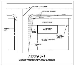
1. In the front yard: fences and walls may be placed on or behind the property line. However, no fence or wall shall exceed four feet in height within the required front yard setback area. In residential districts, six feet shall be the maximum height in the front yard behind the required setback. See Figure 5-1, Typical Residential Fence Location. In commercial and industrial districts, eight feet shall be the maximum height in the front yard behind the required setback.
2. In the side yard and street side yard: fences and walls may be placed on or behind the property line. In residential districts, six feet shall be the maximum height; provided, that no six-foot street side yard fence shall extend past the front corner of the dwelling into the front yard or be located within the clear view triangle. See Figure 5-1, Typical Residential Fence Location. In the commercial and industrial districts, eight feet shall be the maximum height.
3. In the rear yard: fences and walls may be placed on or behind the property line. In the residential districts six feet is the maximum fence or wall height in the rear yard; provided, that when the rear yard abuts a designated arterial, the maximum height shall be eight feet. Eight feet is the maximum rear yard fence height in the commercial and industrial districts.
4. Within the clear view triangle: no fence, hedge or wall, exceeding two and one-half feet in height, shall be placed in the clear view triangles established in YMC 15.05.040.
5. Fences over six feet in height: all fences over six feet in height shall meet the provisions of the International Building Code.
6. Fence height in combination with a retaining wall: no combination of a fence and retaining wall shall exceed a height of ten feet, measured from the lower elevation, except existing retaining walls at the time of the passage of this title will be allowed a three-and-one-half-foot fence above the retaining wall.
H. Access Required. All new development shall have a minimum of twenty feet of lot frontage upon a public road or be served by an access easement at least twenty feet in width. The purpose of this standard is to provide for vehicular access to all new development; provided, the construction of single-family and two-family dwellings on existing legally established lots is exempt from the requirements of this section.
I. Recreational Screen. A recreational screen is a protective device for recreational purposes designed to keep recreational equipment within or outside of a designated area. Such uses are typically associated with schools, parks, golf courses, swimming pools, ballfields, and playgrounds. The specific standard for screen height in Table 5-1 does not apply to recreational screening as established by this title. The height and materials for screens will be evaluated by the administrative official based on the need, safety requirements, and relationship to residential and commercial properties and streets.
J. Sidewalk Requirement. Sidewalks on one side of the street are required with new construction (except single-family structures). A sidewalk is required if one exists within two hundred feet of the development on the same side of the street. Replacement of existing sidewalk is required only if existing sidewalk presents a safety hazard, except that for applications under the jurisdiction of the city of Yakima, the provisions of Title 12 of the Yakima Municipal Code shall prevail over the provisions of this section to the extent of any conflict between such provisions.
K. Swimming Pools. Swimming pools, as defined by the Washington State Residential Code, are permitted as an accessory use to: dwellings, hotels/motels, congregate living facilities, retirement homes, other residential uses, schools, and recreational facilities when all of the following provisions are met:
1. Setbacks.
a. Front yard: The swimming pool, apron, and pump house meet the required front yard setback in Table 5-1.
b. Side and rear yard: The swimming pool and pump house are set back at least three feet from the property line. The swimming pool apron may extend up to the property line.
c. From an easement: The swimming pool, apron, and pump house may extend up to, but shall not encroach upon, an easement.
2. Security. The area around the pool shall be enclosed by a protective fence not less than four feet in height, or by another prescriptive measure as permitted by the Washington State Residential Code.
L. Development within the State Fair Park. The following structures may be developed, maintained, altered, expanded, or erected within the State Fair Park without further zoning review provided such development is consistent with YMC 15.04.200(C), Allowable Uses, SEPA mitigation where required, the development standards of this code and other construction permit requirements:
1. Administrative and operational offices.
2. Auditoriums, meeting and exhibit halls.
3. Bars and drinking facilities.
4. Campgrounds.
5. Caretaker and/or employee residential quarters.
6. Equestrian facilities.
7. Exposition structures.
8. Grandstand facilities.
9. Libraries and museums.
10. Livestock barns.
11. Motorized sports facilities.
12. Parking facilities. (Ord. 2022-011 § 1 (Exh. A), 2022; Ord. 2016-029 § 1 (Exh. A) (part), 2016: Ord. 2011-52 § 5, 2011: Ord. 2010-16 § 6, 2010: Ord. 2008-46 § 1 (part), 2008: Ord. 2005-81 § 4, 2005; Ord. 2001-13 § 48, 2001; Ord. 95-36 § 3, 1995; Ord. 93-81 §§ 23—25, 1993: Ord. 3106 §§ 11, 12, 1988; Ord. 3019 §§ 21—23, 1987; Ord. 2947 § 1 (part), 1986).
15.05.030 Creation of new lots—Subdivision requirements.
A. Table of Subdivision Requirements. The provisions of this section and the requirements set forth in Table 5-2 are hereby established for all subdivisions in the zoning districts indicated. In the case of conflict between the text and tables, the text shall govern. Additional subdivision requirements are established in YMC Title 14.
B. Maximum Number of Dwelling Units Permitted per Net Residential Acre. Maximum number of dwelling units permitted per net residential acre is used to determine the maximum number of dwelling units permitted within a single subdivision, short subdivision, mobile home park, multifamily development, or planned residential development. This standard is intended to:
1. Assure that residential densities in new subdivisions, multifamily developments, or planned residential developments are compatible with the existing or planned level of public services and the density of the zoning district;
2. Permit the clustering of dwelling units (when clustering occurs, open space shall be provided in accordance with YMC 15.09.030); and
3. Permit a variety of residential dwelling types within a development.
The following formula shall be used to determine the maximum number of dwelling units permitted for any particular subdivision, short subdivision, mobile home park, multifamily development or planned residential development:
THE MAXIMUM NUMBER OF UNITS PERMITTED ON A SITE = (the total site area in acres) - (the area of streets, rights-of-way, and access easements, in acres) x (the maximum number of dwelling units permitted per net residential acre).
Any fraction of a dwelling unit shall be rounded up to the next whole number if one-half or over or down to the next whole number if less than one-half. Once approved under the provisions of this title, no subdivision, resubdivision, or short subdivision shall be further modified or divided in a manner that will raise the density of the subdivision beyond the maximum number of dwelling units permitted per net residential acre by Table 5-2; provided, that development exceeding the maximum number of dwelling units per net residential acre may be allowed in accordance with Table 4-1.
The application of this provision shall not prohibit the subdivision of land already developed with more dwelling units than would be permitted by this section when:
1. The lots created meet the lot size and lot width requirements established in Table 5-2;
2. The existing structures meet the building area and setback requirements in Table 5-1; and
3. The new density is consistent with the district intent statement and YMC Table 4-1.
C. Minimum Lot Size. Minimum lot size is the smallest lot size permitted in a particular zoning district when land is subdivided, short platted, resubdivided, or when lot lines are adjusted. No lot shall be created that is smaller than the applicable minimum lot size standard established in Table 5-2.
1. In residential districts, this standard is intended to maintain the residential character of the area and will vary by dwelling type, the suitability of the land for development, and the type of water and sewer system. The following are the minimum lot size requirements in the residential districts, except when the Yakima health district determines that a larger area is necessary for the safe installation of approved water supply and sewage disposal systems:
|
Situation |
Required Minimum Lot Size |
|---|---|
|
In the floodplain, airport, and greenway overlay districts: |
One acre (provided the minimum lot size of the underlying zoning district shall apply, when, in the opinion of the reviewing official, the lot has a buildable area outside the overlay district and a plat restriction prohibits development on that portion of the lot within the overlay district). |
|
Individual water system and individual sewer system: |
One-half acre. |
|
Public or community water system and an individual sewer system: |
14,500 square feet. |
|
Individual water system and the regional or an approved community sewer system: |
9,600 square feet. |
|
Public or community water system and the regional or an approved community sewer system: |
See Table 5-2. |
2. The smaller lot size for zero lot line, attached, and multifamily dwellings does not permit an increase in the maximum number of dwelling units per net residential acre established in subsection B of this section. Any lots created for zero lot line, attached, and multifamily dwellings shall be so designated on the face of the plat or short plat.
3. In the local business district, the minimum lot size is intended to maintain the character of the district and provide adequate space for off-street parking and landscaping.
4. The minimum lot sizes in the small and large convenience center districts and industrial districts are intended to accommodate the large uses permitted in these districts and maintain vacant land in relatively large parcels that can be easily assembled when development is proposed.
D. Standard Lot Width. Standard lot width is the minimum lot width generally permitted in a particular zoning district. The intent of this standard is to prevent irregularly shaped lots along, and to control access to, rights-of-way.
E. Concurrent Subdivision and Zoning Review Required. Any application for a long subdivision which proposes a use or configuration of land or improvements requiring Type (1), (2) or (3) review under this title shall, at or prior to the filing of such application, also file an application for such review under this title. Such application shall be heard by the hearing examiner concurrently with the subdivision application using the procedures for Type (3) review.
|
SITE DESIGN REQUIREMENTS AND STANDARDS |
ZONING DISTRICTS |
||||||||||||||||
|---|---|---|---|---|---|---|---|---|---|---|---|---|---|---|---|---|---|
|
SR |
R-1 |
R-2 |
R-3 |
HB |
B-1 |
B-2 |
SCC |
LCC |
CBD |
GC |
AS |
RD |
M-1 |
M-2 |
|||
|
DEVELOPMENT ON EXISTING LOTS OR PARCELS |
|||||||||||||||||
|
LOT COVERAGE 1 |
60% |
80% |
85% |
90% |
100% |
||||||||||||
|
STANDARD STRUCTURE SETBACKS 6 (in feet) |
FRONT |
Arterials 2 |
60 |
40 |
|||||||||||||
|
Collector Arterials 2 |
50 |
30 |
|||||||||||||||
|
Local Access 2 |
45 |
||||||||||||||||
|
Private Road 2 |
37.50 |
||||||||||||||||
|
Private Access Easement 3 |
10 |
||||||||||||||||
|
SIDE |
Arterials 2 |
50 |
40 |
||||||||||||||
|
Collector Arterials 2 |
40 |
30 |
|||||||||||||||
|
Local Access 2 |
|||||||||||||||||
|
Private Road 2 |
32.50 |
||||||||||||||||
|
Private Access Easement 3, Alley, or Property Line 7 |
5 |
10 8 |
0 |
||||||||||||||
|
Residential District 4 |
5 |
20 |
30 |
||||||||||||||
|
or 1/2 building height, whichever is greatest |
|||||||||||||||||
|
REAR 6 |
Alley or Property Line |
15 |
15 |
15 |
0 |
||||||||||||
|
Residential District 4 |
20 |
30 |
|||||||||||||||
|
or 1/2 building height, whichever is greatest |
|||||||||||||||||
|
MAXIMUM BUILDING HEIGHT (in feet) |
35 |
50 |
35 |
50 |
N/A |
50 |
N/A |
||||||||||
|
STANDARD FENCE HEIGHT 6 |
See YMC 15.05.020(G) |
||||||||||||||||
|
STANDARD SCREEN HEIGHT |
In Required Front Setbacks |
Not Permitted |
|||||||||||||||
|
Behind Required Front Setbacks |
15 |
||||||||||||||||
NOTES:
1. Landscaping may be required pursuant to YMC Ch. 15.06.
2. The setback is measured from the centerline of rights-of-way (or access easement, in the case of private roads). In the residential districts, the minimum front yard setback shall be twenty feet from the front property line and the minimum side yard setbacks shall be ten feet from the side property line abutting the right-of-way.
3. The setback is measured from the edge of the access easement.
4. Measured from abutting residential district.
5. Additional setbacks may be required to conform to sitescreening requirements in YMC Ch. 15.07.
6. The rear setback from arterials, collectors, and local access streets shall be the same as the front yard setback requirements from arterials, collectors, and local access streets, provided the required rear setbacks shall not be less than the required setbacks from the property line. (See also Note 3.)
7. Zero lot line dwelling units are allowed a zero-foot setback from one side property line not abutting a right-of-way. (See YMC Ch. 15.09.)
8. The minimum side yard setback in the R-3 zoning district for single-family homes, duplexes, and common-wall structures shall be five feet from property line.
|
Subdivision Requirements |
Zoning Districts |
||||||||||||||||
|---|---|---|---|---|---|---|---|---|---|---|---|---|---|---|---|---|---|
|
SR |
R-1 |
R-2 |
R-3 |
HB |
B-1 |
B-2 |
SCC |
LCC |
CBD |
GC |
AS |
RD |
M-1 |
M-2 |
|||
|
Maximum Number of Dwelling Units Permitted per Net Residential Acre |
See YMC Ch. 15.04, Table 4-1 |
Not Permitted |
|||||||||||||||
|
Minimum Lot Size (in square feet)(3) |
Residential Uses See Definitions in YMC Ch. 15.02 |
Detached S.F. Dwelling |
6,000 |
6,000 Where Permitted |
|||||||||||||
|
S.F. Dwelling, Zero Lot Line(4) |
4,000 |
3,500 |
|||||||||||||||
|
S.F. Dwelling, Common Wall |
|||||||||||||||||
|
Two-Family Dwelling |
8,000 |
7,000 |
|||||||||||||||
|
Multifamily Dwellings and PD—Residential |
Density May Not Exceed Maximum Number of Dwelling Units Permitted per Net Residential Acre |
||||||||||||||||
|
Permitted Nonresidential Uses(5) |
10,000 |
5,000 |
10,000 |
None |
1/2 Acre |
||||||||||||
|
Standard Lot Width(2) (in feet) |
ALL Except Common Wall Dwelling (per Unit) |
60 |
50 |
None |
60 |
||||||||||||
|
Common Wall Dwelling (per Unit) |
35 Where Permitted |
||||||||||||||||
NOTES:
1. In the residential districts, these minimums apply when lots are served by a public or community water system and either the regional or approved community sewer system.
2. The lot width at the rear line of the required front yard shall not be less than fifty feet. (Note: this provision only applies to those districts with a minimum lot width of fifty feet or larger.)
3. One acre shall be the minimum lot size in residential districts within the floodplain and greenway overlays.
4. See special development standards for zero lot line development, YMC 15.09.040.
5. Lots created for utility purposes may be created below the minimum lot size listed in YMC Ch. 15.05, Table 5-2, as long as the lot is designated as “nonbuildable lot for utility purposes” on the face of the plat and the proposed lot is reviewed for compatibility. The lot must still meet the minimum lot width established in YMC Ch. 15.05, Table 5-2, and structures built on the lot must still meet the setback requirements in YMC Ch. 15.05, Table 5-1.
(Ord. 2023-026 § 1 (Exh. A), 2023; Ord. 2022-011 § 1 (Exh. A), 2022; Ord. 2016-029 § 1 (Exh. A) (part), 2016: Ord. 2012-34 §§ 3, 4, 2012; Ord. 2011-52 § 6, 2011: Ord. 2010-16 § 7, 2010: Ord. 2008-46 § 1 (part), 2008: Ord. 2001-04 § 5 (Att. A), 2001; Ord. 95-13 § 6, 1995; Ord. 3106 § 13, 1988; Ord. 3019 §§ 24, 25, 1987; Ord. 2947 § 1 (part), 1986).
15.05.040 Vision clearance.
A. Intersections. All corner lots at unsignalized street intersections or railroads shall maintain, for safety vision purposes, a vision clearance triangle. The vision clearance triangle shall measure fifteen feet by one hundred twenty feet along the perpendicular lengths formed by three points including:
1. A point at the intersection of the extended curb lines or pavement edge/travel lanes;
2. A point measured one hundred twenty feet from the first point, forming a line along the adjacent perpendicular street curb line or pavement edge/travel lane; and
3. A point measured fifteen feet from the first point, forming a line.
Nothing within the vision clearance triangle shall be erected, placed, planted, or allowed to grow in such a manner as to materially impede vision between the heights of two and one-half and ten feet above the centerline of grades of intersecting streets (and/or railroads) or the future intersection centerline where improvements are planned with the six-year road improvement program, on file in the city engineering division. (See Figure 5-2.)
B. Driveway Curb Cuts or Alleys. This applies only to uses established under the terms of this title. A vision clearance triangle shall be maintained at all driveways, curb cuts, and intersections of an alley with a public street, for vision safety purposes. The vision clearance triangle shall measure fifteen feet along the perpendicular street curb lines, pavement edge, or travel lane of the public street and fifteen feet along the driveway or alley. The third side of the triangle shall be a straight line connecting the fifteen-foot sides described above. No sign or associated landscaping shall be placed within this triangle so as to materially impede vision between the heights of two and one-half and ten feet above the centerline grade of the streets.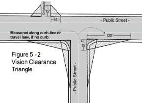
(Ord. 2016-029 § 1 (Exh. A) (part), 2016: Ord. 2008-46 § 1 (part), 2008: Ord. 93-81 § 26, 1993; Ord. 3106 § 14, 1988: Ord. 2947 § 1 (part), 1986).
15.05.050 Street right-of-way dedication.
All new development shall dedicate, where necessary, street right-of-way in conformance with the standards in the county/city subdivision ordinance and the arterial street plan adopted in the Yakima urban area comprehensive plan, except that for application under the jurisdiction of the city of Yakima, YMC Title 12 shall prevail over the provisions of this section to the extent of any conflict between such provisions. (Ord. 2016-029 § 1 (Exh. A) (part), 2016: Ord. 2008-46 § 1 (part), 2008: Ord. 2001-13 § 49, 2001: Ord. 2947 § 1 (part), 1986).
15.05.055 New development improvement standards.
All development within the Yakima urban growth area (UGA) must meet the urban standards of the city of Yakima including the following:
1. Fire apparatus access roads for multiple-family residential developments and one- or two-family residential developments shall be subject to the provisions of Sections D106 and D107, respectively, of Appendix D of the International Fire Code. Additionally, such residential developments shall be subject to the requirements of Section D105 of Appendix D, International Fire Code, pertaining to aerial fire apparatus roads, as applicable. All provisions of the International Fire Code referenced above are hereby adopted and incorporated herein by this reference, as now existing or as hereafter amended and adopted by the city. Minimum requirements for the primary and secondary access will be at least twenty feet wide, unobstructed, paved lanes.
2. In order to promote safety for emergency access and circulation within and between new developments, cul-de-sac streets (public or private) shall not exceed 600 feet. (Ord. 2022-011 § 1 (Exh. A), 2022; Ord. 2016-029 § 1 (Exh. A) (part), 2016: Ord. 2012-34 § 5, 2012: Ord. 2008-46 § 1 (part), 2008).