


SECTION 25.28
OVERLAY ZONING DISTRICTS
Sections:
25.28.2 Establishment and Designation
25.28.3 Downtown Area Parking (P1) Overlay District
25.28.4 Hillside Development (H) Overlay District
25.28.5 North Cordelia (NC) Overlay District
25.28.5A Gateway Court (GC) Overlay District
25.28.5B Emergency Shelter Overlay District (-ES)
25.28.6 Planned Development (PD) Overlay District
25.28.7 Land Use and Development Regulations for Specific Planned Development Overlay Districts
25.28.1 Purpose
The purpose of overlay zoning districts is to allow the City to establish special land use regulations, standards, or procedures in areas with unique land use, site planning, building design, or environmental resource issues. Overlay zoning districts are also an appropriate mechanism to implement long-term goals and land use requirements of the City for a specific property, location, or to coordinate land use and design requirements unique to a large tract of land. Overlay zoning districts are intended to be applied only where special circumstances justify the modification of base zoning district regulations to achieve specific land use and design objectives.
25.28.2 Establishment and Designation
Overlay zoning districts are established through rezoning and only in conjunction with base zoning districts. Letters, numbers, or a combination thereof, shall be combined with other applicable district designations to the property(ies) on which an overlay district is established. Except as modified by the overlay zoning district, the provisions of the applicable base-zoning district shall apply to all development within the boundary of the designated area. If regulations conflict, the applicable overlay zoning district regulations shall prevail.
Whenever an overlay district is established, any subsequent application to change the base-zoning district shall not be construed to be an application to eliminate the overlay district for the property covered by the application. An intent to eliminate the overlay district on a given property shall be expressly stated to be part of the application.
25.28.3 Downtown Area Parking (P1) Overlay District
The purpose of the Downtown Parking Overlay District (P1) is to allow land uses to deviate from the parking requirements of Section 25.34 (Parking and Loading). This deviation is allowed in recognition of the unique characteristics of the downtown area (HO, HD, and HDC zoning districts) such as: mixed uses, pedestrian scale of development, availability of transit, and the urban streetscape. The regulations of this overlay district will allow a reduction in the number of required parking spaces and may permit the use of in lieu fees and off-site parking facilities.
A. Applicability. The (P1) overlay district shall apply to commercial and mixed use properties in the HDC, HD, and HO Zoning Districts.
B. Parking Requirements. The provision of parking shall be according to the following:
1. 100 or fewer spaces required. When a non residential use or uses on a parcel would require 100 or fewer parking spaces as determined by Section 25.34 (Parking and Loading), the required number of parking spaces provided shall be 50 percent of the required number.
2. More than 100 spaces required. When a non residential use or uses on the same parcel would require more than 100 parking spaces, all parking spaces required by Section 25.34 shall be provided. The existence of parking assessment district credits and/or previously paid in lieu fees shall not be taken into consideration as to whether the 100 parking space threshold is exceeded.
C. In lieu fees. The parking requirements of this Section may be satisfied by the payment of a fee in lieu of providing the parking spaces. The amount of the fee shall be determined by the City Council.
The use of in lieu fees for non residential land uses shall be at the discretion of the approval authority. Such use may be denied or limited based on the particular characteristics of the proposed use, adjacent uses, and availability of parking in the vicinity. In-lieu fees shall not be used to satisfy parking requirements for residential uses.
D. Parking assessment district credits. Each property which was included in the 1962-1 parking assessment district shall receive a credit towards required parking equal to the number of parking spaces that the property originally contributed. The amount of the credit for each property has been calculated using the City Engineer’s report for the district. Such credits may be applied only to the particular property, as may be subsequently subdivided or merged, but shall not be transferred or used to satisfy the parking requirement on any other property.
E. Building additions. No additional parking shall be required for structural alterations, repairs, or for building additions less than 400 square feet in area. Any building addition greater than 400 square feet shall provide parking in accordance with subsection 25.28.3 (B). Such addition shall not require the provision of any additional parking for principal building(s) in existence before April 2, 1985.
F. Change of land use. A change in the use of an existing building shall not require the provision of any additional parking spaces unless both the following are found to exist:
1. The new use would require more than 100 parking spaces as calculated in the manner specified by subsection 25.28.3 (B) above, and
2. The new use would require 25 percent more parking spaces than the most recent use of the building.
When a new use requires more than 100 parking spaces, the required amount shall be provided through on site parking, off site parking, in-lieu fees, parking assessment district credits, or a combination thereof.
G. Off site parking. Required parking may be located off-site when located within 300 feet from the property.
H. Records. The Department of Community Development shall maintain a record of parking assessment district credits or in lieu fees paid for each lot within the (P1) district. This record shall contain the total number of parking spaces to which each property is entitled. (Ord. No. 85.10, § 3; Ord. No. 2012-04, § 2; Ord. No. 2018-03, § 6.)
25.28.4 Hillside Development (H) Overlay District
A. Purpose and intent. The purpose and intent of the Hillside Overlay District (H) is to:
1. Implement the City’s General Plan by establishing hillside regulations and management guidelines to ensure:
a. The preservation of scenic hillside areas and prominent topographic features including ridgelines, steep slopes, and hillsides; and natural features such as tree stands and riparian areas;
b. That development of hillside areas is sensitive to, and preserves natural features; and maximizes open space preservation to enhance the City’s identity and preserve surrounding natural environments;
c. The sound planning of hillside areas deemed appropriate for development;
2. Establish development regulations and hillside management guidelines that address areas of concern unique to hillside projects such as: open space preservation; grading, drainage and erosion control; roadway and driveway design; lot placement and size; public safety; architecture; and landscape design;
3. Maintain an environmental equilibrium consistent with existing vegetation, wildlife, soils, geology, slopes and drainage patterns and to preserve the natural topography, including swales, canyons, knolls, ridgelines and rock outcrops;
4. Avoid development that would result in unacceptable fire, flood, landslide or other safety hazards;
5. Avoid unwarranted high maintenance costs for public facilities or land; and
6. Provide a mechanism for flexible residential development projects in hillside areas so that development may be concentrated in those areas with the least environmental and aesthetic impact.
B. Establishment and designation. The (H) overlay district should be applied to sites with slopes of 5 to 10 percent, on all or a portion of the property, or that are otherwise located on prominent hills within the community or on the lower slopes of hillsides at the periphery of the City. Land with these characteristics shall be considered for inclusion in the (H) district when an annexation application is being considered by the Planning Commission and City Council. Property designated by the General Plan as Intensive or Extensive Agriculture, Open Space Recreation, or Open Space Conservation is not intended to be zoned within the (H) district.
C. Development regulations. Development within the (H) overlay district shall comply with the requirements of the base zoning district and the Hillside Management Guidelines established by Resolution of the City Council.
D. Procedures. Hillside Management Guidelines shall be established by Resolution of the City Council and shall address the submittal requirements and processing procedures for projects within the (H) overlay district. The Director of Community Development shall have the authority and responsibility to establish specific submittal requirements and procedures necessary for the review and processing of all land use applications within the Hillside Overlay, consistent with the hillside management guidelines, and other applicable City and State requirements.
E. Review and findings. All applications within the (H) overlay district shall be reviewed in accordance with the applicable standards for land use and development applications provided in this Zoning Ordinance and Chapter 12D (Open Space Preservation) of the City Code, and for compliance with the Hillside Management Guidelines. The approval authority shall make the required findings provided for in Chapter 12D and this Zoning Ordinance. Prior to granting any approval of a land use or development application within the (H) overlay district, to the extent that they are applicable to the approval being requested, the approval authority shall find that the proposed project is in compliance with the Hillside Management Guidelines; and
1. Prominent natural features on the site will be preserved.
2. Development will generally occur in valleys and on the lower elevations of a site
3. A natural appearance will be provided and maintained along the boundary between development and open space;
4. Off-site views of the project will be minimized by the placement and design of improvements;
5. The project is designed in consideration of the long term quality of the design solution; and
6. The project includes provisions for public facilities and/or other amenities as needed to support the development.
F. Fees. The City Council may establish a fee to off-set the additional administrative costs of review and processing applications for development within the (H) overlay district.
25.28.5 North Cordelia (NC) Overlay District
A. Purpose and intent. The purpose and intent of the North Cordelia Overlay District (NC) is to implement the Green Valley Settlement Agreement (GVSA).
B. Applicability and expiration. The (NC) overlay district is applied to all properties within the City located north of Interstate 80 and west of Suisun Valley Road in Cordelia, as identified on the Zoning Map.
C. North Cordelia Design Standards. All development within the (NC) district shall comply with the North Cordelia Design Standards, contained in Resolution 89-384, adopted by the City Council on November 21, 1989, as may be amended. The approval authority shall find that the proposed development is in compliance with the design standards prior to granting any development approval within the (NC) overlay district.
D. Traffic standards. Within the (NC) overlay district, the City shall not approve any disposition and development agreement or other discretionary permit for commercial development that is greater than 10,000 square feet, or that generates more than 150 daily trips, if calculated Levels of Service (LOS) at the time of approval at any major intersection, as defined in Section 6.1 of the Green Valley Settlement Agreement, is either operating at a level of service lower than LOS D, as a result of the proposed approval in combination with existing traffic levels and projected traffic from the projects described in Section 1.29 of the Green Valley Settlement Agreement, and all other approved residential and commercial agreements in North Cordelia.
E. Public art. Development within the boundary of the (NC) district shall include public art in the project or pay an in-lieu in fee. As required by the Price Club Settlement Agreement (City Council Resolution 91-277), a public art fee equal to 0.0025 percent of the building permit valuation for a project shall be paid concurrent with issuance of a building permit. In lieu of payment of this fee, the developer may purchase public art or construct public art for inclusion in the project. Public art shall include, but shall not be limited to water features, sculptures, and tapestries. Design features incorporated into proposed building architecture, such as cornices, pilasters, or special paving materials are not considered public art. The City shall approve all public art projects.
25.28.5A Gateway Court (GC) Overlay District
A. Purpose and intent. The purpose and intent of the Gateway Court Overlay District (GC) is to facilitate the continued success of the restaurant cluster on Gateway Court and to prohibit or discourage incompatible uses.
B. Applicability and expiration. The (GC) Overlay District is applied to parcels located south of Gateway Court near the northwest corner of Gateway Blvd and Travis Blvd extending to the west side of Maupin Court.
C. Permitted Land Uses. Permitted land uses in the (GC) Overlay District are as follows:
Restaurant, Table Service
Restaurant, Counter Service
D. Conditionally Permitted Land Uses. Land uses permitted with a Conditional Use Permit are as follows:
|
New merchandise sales, less than 80,000 s.f. |
Community Center/Banquet Hall |
|
Apparel and shoes |
Catering service |
|
Florist |
Food and beverage sales |
|
Market, specialty food and beverage |
Entertainment with any food service |
|
Photo, video, and electronics |
Banks |
|
Commercial recreation |
|
E. Development Standards. Development standards shall be as established for the CR Zoning District in Table 25-10.
(Ord. No. 2013-17, § 2; Ord. No. 2015-06, § 2.)
25.28.5B Emergency Shelter Overlay District (-ES)
A. Purpose and intent. The purpose and intent of the Emergency Shelter Overlay District (-ES) is to establish as-of-right (permitted) development and operation of emergency shelters in appropriate locations and to facilitate the ability of emergency shelters to expand as needed to serve homeless and potentially homeless residents of Fairfield in accordance with State law.
B. Applicability.
1. The (-ES) Overlay District shall apply to properties in the IL Zoning Districts with an IL-ES designation.
2. Notwithstanding the above, the City Council may by ordinance allow an emergency shelter to operate on a temporary basis on properties in other zoning districts, in order to meet immediate shelter needs during a local emergency or state of emergency as described in Chapter 6 of the City Code. Such emergency shelter use shall comply with the development standards of this section. Upon termination of the emergency, the emergency shelter shall immediately cease operations and shall no longer be permitted.
C. Permitted Land Uses. All land uses within an (-ES) Overlay District shall comply with the applicable base Zoning District or other applicable Overlay District, except the following additional use shall be a permitted (P) land use in the (-ES) Overlay District:
1. Homeless Shelter as defined in Section 25.50 of the Fairfield Zoning Ordinance.
D. Development Standards. Development Standards in the (-ES) Overlay District shall be those established for the base Zoning District. In addition, Homeless Shelters shall comply with following operational and development standards:
1. Occupancy. No emergency shelter shall exceed a capacity of 250 residents on any single parcel.
2. Length of Occupancy. Resident’s stay shall not exceed six consecutive months.
3. Zone Specific Development Standards. An emergency shelter shall comply with all development standards of the applicable zoning district in which it is located.
4. Parking Requirements. Emergency shelters shall provide one parking space for every staff member and one parking space for every 10 residents.
5. Management. An emergency shelter must prepare and implement a Management Plan for the property. In addition, all emergency shelters shall implement the following management practices:
a. Shelter operations shall ensure that prospective and current residents do not wait outside the shelter on sidewalks or any other public rights-of-way.
b. Security shall be provided on site during hours of operation.
c. On-site management shall be provided by at least one emergency shelter staff member at all times while residents are present at the shelter. (Ord. No. 2015-04, § 2; Ord. No. 2020-15, § 2.)
25.28.6 Planned Development (PD) Overlay District
A. Purpose and intent. This Section is intended to encourage innovations through regulations that will:
1. Promote creative and imaginative designs, superior to those attainable under conventional zoning district standards, by allowing greater flexibility in the application of land use and development regulations;
2. Encourage the assembly and integrated development of parcels that might otherwise be developed in unrelated increments to the detriment of surrounding neighborhoods, and the variety and diversity in the development of large-scale projects;
3. Promote a more economic and efficient use of land by allowing a variety of housing choices, commercial and industrial activities, a high level of urban amenities, and the preservation of open space; and
4. Safeguard the environment and enhance the aesthetics of the community by preserving environmentally sensitive areas, prominent natural features, and cultural or historic resources. While use of the Planned Development overlay district is an effective planning tool to achieve the above purposes, it is not the City’s intent to confer special privileges to any land owner or compensate a land owner for areas of a property that are otherwise unbuildable due to existing features or constraints on the property.
B. Applicability and designation on Zoning Map. The Planned Development overlay district shall be applied to property through rezoning pursuant to Section 25.47 (General Plan and Zoning Amendments), and may be combined with any base zoning district established by Section 25.12.2 (Zoning Districts Established) including other overlay districts. This district shall be designated on the Zoning Map by the suffix “PD” followed by a file number assigned by the Department.
C. Five acre minimum site. A Planned Development overlay district may be used in conjunction with any base zoning district designation on a site with a minimum of five acres of gross developable land area (See Section 25.50, Definitions).
D. Special initiation procedure. Initiation of a Planned Development overlay district rezoning shall only be by Resolution of the Planning Commission or City Council at a public hearing. The Department shall prepare a report that describes the purpose of the proposed Planned Development rezoning and what alternatives are available to accomplish the stated objectives (e.g., changes to a project, rezoning to another base zone, or a text amendment to the Zoning Ordinance). If the Commission or Council chooses not to initiate a PD overlay district filed by a property owner, all unexpended processing fees related to the PD overlay district application shall be refunded to the applicant.
E. Application contents/Master Development Plan. All applications for rezoning to a PD overlay district shall be filed with the Department of Community Development as prescribed by the Director. The application shall include a Master Development Plan that shows the proposed development in sufficient detail for thorough analysis of the proposal and its potential impact on nearby properties and land uses.
At a minimum, the Master Development Plan shall identify the following:
1. A statement of goals and objectives for the project, and explanation of why a Planned Development overlay district is necessary;
2. Principal circulation routes and access points, including public right-of-way widths;
3. Base zoning designations of all land, including lands to be preserved and public facilities;
4. Community design elements, including parkways and other landscape features, fencing and wall plans, streetscape and hardscape amenities, and architectural concepts; and
5. Special regulations, standards, or design guidelines necessary to establish and implement the objectives of the Master Development Plan.
An approved Master Development Plan shall serve as an exhibit of the Zoning Map and shall provide direction for future development of the PD overlay district.
F. Modification of land uses. All land uses within a Planned Development overlay district shall comply with the applicable base-zoning district, except when the approved Master Development Plan includes specific revisions to allowable land uses. While a Master Development Plan is intended to establish the overall pattern of land uses and density/intensity of development within the boundaries of a Planned Development overlay zone, the permitted and conditionally permitted uses should be as regulated by the underlying base zone(s). Specifically, a Planned Development overlay district shall not be used to prohibit locally undesirable land uses. However, where modification to allowed uses is necessary to carry out the purpose of the Ordinance and the objectives of the overlay zone, they may be approved if the facts of the case justify the findings contained in Section 25.28.6 (H) below.
Where revisions to allowable base zones are proposed, the applicant shall provide written justification as to why the modification is necessary. Additional land uses may be added if the City finds that such land uses are consistent with the General Plan, Specific Plan, or other applicable plans.
G. Development regulations. All development regulations within a Planned Development overlay district shall comply with the base-zoning district applicable to the property, unless the district’s provisions specifically state otherwise. Special regulations, design standards, infrastructure requirements, environmental mitigation measures, and the like may be applied to Planned Development overlay districts as determined necessary by the City to implement the purposes of this Ordinance and the objectives of the Master Development Plan.
Where modification of base zoning district development regulations is proposed, the applicant shall provide a written justification as to why the base zoning district does not allow for the reasonable accommodation of such development. Modification to development regulations may be approved if the facts of the case justify the findings contained in Section 25.28.6 (H) below.
H. Findings for approval. Prior to the approval of a Planned Development rezoning, the findings required in Section 25.47 (General Plan and Zoning Amendments) and as follows shall be made by the City Council:
1. The proposed Planned Development overlay district is necessary to promote the efficient use of land, safeguard the natural and built environment, obtain high-quality public amenities, and/or achieve creative and imaginative design superior to that which would be attainable under conventional zoning district regulations.
2. If the Planned Development overlay district will modify the allowable uses or development regulations in any base zone district, the following findings shall be made:
a. That the change to permitted or conditionally permitted uses is necessary to achieve specific objectives to the Master Development Plan, and that the revision does not have the effect of restricting locally undesirable land uses within the project.
b. The land uses and development regulations allowed by the Master Development Plan are consistent with the General Plan.
I. Conditions of Planned Development rezoning. As a condition of rezoning to a PD overlay district, the City may apply other regulations determined necessary to implement the intent and purpose of the district. These regulations may include, but are not limited to, design standards, infrastructure requirements, and environmental mitigation measures.
J. Subsequent development approvals within Planned Development Overlay District. All land use and development approvals within a PD overlay district shall be in substantial compliance with the approved Master Development Plan. Deviations of substance shall require an amendment to the Planned Development overlay district regulations. Minor revisions consistent with the purpose and intent of the approved Master Development Plan may be authorized by the Planning Commission with the approval of Master Development Plan Amendment (see subsection K below).
K. Master Development Plan Amendment. The Master Development Plan Amendment process allows for minor modifications to the land use boundaries or conditions of approval associated with a Master Development Plan. Land use boundaries may be adjusted only to the extent that the diversity of all land uses is maintained and the overall density or intensity of land uses is within 10 percent of that identified in the Plan (e.g., number of dwelling units, floor area ratio, etc.).
1. Application filing and processing. An application for a Master Development Plan Amendment shall be filed and processed in compliance with Section 25.41 (Application Filing, Processing, and Approval).
2. Project review, notice, and hearing. Each Master Development Plan Amendment application shall be analyzed to ensure that the application is consistent with all applicable provisions of this Ordinance. Each application shall be reviewed and acted upon by the Planning Commission at a public hearing held in compliance with Section 25.43 (Public Hearings).
3. Findings, decision, and conditions. Following a public hearing, the Director shall record the Commission’s decision and the findings upon which the decision is based. The Commission may approve a Master Development Plan Amendment with or without conditions when it finds that the proposed amendment:
a. Is consistent with the intent and purpose of the Master Development Plan;
b. Will result in development that is equal to or superior quality to that approved in the original Master Development Plan; and
c. Is compatible with the existing and anticipated land uses in the vicinity.
25.28.7 Land Use and Development Regulations for Specific Planned Development Overlay Districts
This section establishes additional land use and development regulations for specific Planned Development overlay zones identified on the Zoning Map. When the language contained within any of the Planned Development zones referenced below (e.g., Z.C. 85-14) makes reference to Planned Unit Development permit approval for minor modifications to development standards, the Master Development Plan Amendment process identified in the previous section shall be used instead. Consistent with the Master Development Plan Amendment section, these changes to development regulations shall be limited to land use boundaries and conditions of approval, and shall not include changes to land uses, allowable densities, and similar regulations, which would require a Zoning Map Amendment.
A. Eastridge. The following Regulations shall apply in the Eastridge PD overlay district:
1. A maximum of 217 single-family detached dwelling units are permitted.
2. The project is permitted one single street intersection with Green Valley Road. No access to any residential lot shall be directly from Green Valley Road.
3. For tree or hillside preservation purposes, the Director shall have the ability to approve a 20 minimum front instead of the 25 foot front yard required by the Residential - Low Density Zoning District.
B. Mangels Ranch. The following regulation shall apply in the Upper Mangels PD overlay district: A maximum of 229 single family detached dwelling units are permitted.
C. Rancho Solano. The following regulations shall apply in the Rancho Solano PD overlay district:
1. A maximum of 1,200 dwelling units is permitted within the project.
2. In addition to the underlying land use designations, development shall comply with the provisions of Ordinance 85-14, and by reference the following plans and documents on file in Planned Development zoning file Z.C. 85-3: “Rancho Solano Illustrative Plan”; “Rancho Solano Open Space Concept - Land Use - Sheet 1”; “Land Use Plan, Sheet 1”; “Land Use Plan, Sheet 1A”; “Rancho Solano, Sheet 2, revised 12/14/84”; and Rancho Solano, A Planned Unit - Golf Course Development.”
3. Concurrent with the filing each final map for a development area, the remaining property outside the developed area within the map shall be designated Open Space Conservation and placed within the Conservation Easement for Rancho Solano.
D. Gold Ridge. The following regulations shall apply in the Gold Ridge PD overlay district: In addition to the underlying land use designations, development shall comply with the provisions of Ordinance 97-12, and by reference the approved land plans titled “Planned Unit Development Zoning Map, Gold Ridge, Fairfield, California” dated “Received May 27, 1997” and plans titled “Community Design Plan for Gold Ridge at Cannon Station” dated 8 May 1997, on file in Planned Development zoning file Z.C. 97-5.
E. Fieldcrest. The following regulations shall apply in the Fieldcrest PD overlay district:
1. In addition to the underlying land use designations, development shall comply with the provisions of Ordinance 94-19, and by reference the approved land plan titled “Open Space System, Fieldcrest, Fairfield, CA” dated April 22, 1994, on file in Planned Development zoning file Z.C. 84-8.
2. The 63-acre Open Space area indicated on the Section Zoning Map contained in Ordinance 94-19 shall be dedicated as a conservation easement to the City or other third party foundation, prior to or concurrent with recordation of any Final Subdivision Map on the project.
F. Garibaldi Ranch. The following regulations shall apply in the Garibaldi Ranch PD overlay district:
1. A maximum of 673 dwelling units is permitted within the project.
2. In addition to the underlying land use designations, development shall comply with the provisions of Ordinance 97-14, and by reference the approved land plans titled “Garibaldi Ranch Planned Unit Development Zoning and Development Standards Exhibit”; the “Garibaldi Ranch Concept Elements Exhibit”; and “Garibaldi Ranch, A New Neighborhood of Cordelia Village” dated July 28, 1997, on file in Planned Development zoning file Z.C. 97-7.
3. The areas designated Open Space on the approved land plans referenced in G.1. shall be dedicated, via conservation easement or other form satisfactory to the City, prior to or concurrent with recordation of the first Final Subdivision Map on the project.
G. Waterman Ranch House. The following regulations shall apply in the Waterman Ranch House PD overlay district:
1. The historic architectural integrity of the building exteriors on the property shall be maintained. Any modifications to the building exterior shall be approved by the City to ensure consistency with this requirement.
2. The only type of livestock allowed on the property shall be horses and their number shall be limited to four.
3. Further subdivision of the existing parcels, as depicted on the Planned Development Zoning Map, certified approved by the City on December 8, 1984, is prohibited.
4. The Waterman Ranch property shall be made available for public viewing two times per year, between the hours of 10:00 AM and 5:00 PM, on dates approximately six months apart. The exact dates shall be established by the City and property owner on an annual basis. Groups proposing to view the property shall be required to apply to the City for approval and scheduling.
H. Stonedene. The following regulations shall apply in the Stonedene PD overlay district:
1. With the exception of a parking lot to serve the offices uses, no new development shall be allowed on the site. This condition may be modified by the City Council if the applicant does not receive from the City development rights elsewhere in exchange for preserving an approximately 1.94-acre portion of the Stonedene site.
2. The Stonedene mansion shall be open for public tours at least four times per year. The applicant shall work with the City to establish the dates and times for the tours.
3. Exterior modifications of the Stonedene building shall be subject to approval by the Planning Commission. Exterior modifications of the building shall not include an expansion of the floor area of the building.
I. Western Business Park. The following regulations shall apply to the portion of Western Business Park identified as having a PD overlay:
1. The required rear yard setback for any property abutting the Linear Park shall be ten feet.
2. On property abutting the linear park, the rear setback area to be landscaped shall be zero to 10 feet as determined necessary through the Development Review process based on the need to screen outdoor storage.
3. As a condition of Conditional Use Permit or Development Review approval for any development abutting the Linear Park, a cash deposit or in lieu fee acceptable to the Director of Community Development shall be required for wall construction on the north boundary of the Linear Park.
J. North Gate. The following requirements shall apply in the North Gate PD overlay district:
1. The purpose of this Planned Development (PD) Zoning District is to provide housing for exclusive use of military families.
2. Development standards and operation shall be as outlined in the original Planned Unit Development Permit and Planned Development Zoning Z.C. 88-15.
3. New development and/or redevelopment in the North Gate Planned Development District shall require a Zone Change to the Train Station Specific Plan Zoning District (P.D. 2011-1). Said new development/redevelopment shall comply with all requirements of the Train Station Specific Plan, including in particular the following requirements:
A. Maximum Development. Planning Area 9A was developed with approximately 300 multifamily apartment units for active military personnel. The lease has expired and the housing is currently vacant. Continued use of the property consistent with the existing North Gate Planned Development Zoning is permitted to continue.
Any redevelopment or change in use from current military housing use will require a Specific Plan Amendment. If the property owner wishes to receive water and sewer service from the City of Fairfield, they will be responsible for constructing all utilities, paying all impact fees, reimbursements, connection fees, and annexing into any Community Facilities Districts formed by property owners in the remainder of the Train Station Specific Plan Area.
B. Development Regulations.
1. Permitted Uses.
Land uses in Planning Area 9A shall be limited to existing military housing uses permitted under the existing North Gate Planned Development Zoning. Changes in land use will require rezoning, a Zoning Ordinance Amendment, an amendment to the Specific Plan and a Planned Unit Development Permit.
2. Development Regulations.
No new development is permitted in Area 9A without an Amendment to the Specific Plan, General Plan Amendment, and Zoning Ordinance Amendment.
K. Train Station Specific Plan PD Overlay District.
Purpose and intent. The purpose and intent of the Train Station Specific Plan PD Overlay District is to implement the vision outlined in the adopted Train Station Specific Plan.
Applicability and expiration. The Train Station Specific Plan PD Overlay District is applied to those properties to be developed in the City of Fairfield located generally south of Goldridge and north of Cement Hill Road, east of Peabody Road, north of Vanden High School and west of North Gate Road as identified on the Zoning Map, with a -PD Zoning Map designation.
Those properties not yet assigned a base zoning district are designated “TS” on the Zoning Map. As base zoning is assigned during the Planned Unit Development Permit process, these properties will be assigned a base zoning designation along with the -PD Zoning Map designation. The TS designation would be removed at that time.
Development and Design Standards. In addition to any development standards outlined for the base zones in this chapter, all development within this PD district shall implement the design standards and vision outlined in the Train Station Specific Plan, as adopted by the Fairfield City Council on July 26, 2011 through Resolution 2011-159. The approval authority shall find that the proposed development is in compliance with the design standards and vision prior to granting any development approval within the Train Station Specific Plan PD Overlay District.
A. General Provisions.
1. Train Station Specific Plan. All development shall be in accord with the policies and standards of the Fairfield Train Station Specific Plan (“Specific Plan”) except as may be explicitly modified by the conditions or processes established herein or in the Fairfield City Code.
2. No Permits Granted. This Zoning Ordinance Amendment does not in itself grant building permits or other entitlements for any residential units or commercial, industrial, institutional, or public buildings or facilities. All projects shall comply with this Planned Unit Development Zoning Ordinance, the Fairfield Zoning Ordinance generally, and undergo the required subdivision map or development review approval process, obtaining Development Review Approval, a Planned Unit Development Permit or Conditional Use Permit, as required, as well as pay all fees.
3. Maximum Number of Dwelling Units. The maximum number of dwelling units permitted in this Planned Unit Development Zoning District is 6,800. This number is distributed among the Planning Areas in the Specific Plan Area as described in Table 4-1, attached herein.
4. Transfer of Dwelling Units. Dwelling units may be transferred between and within the Planning Areas defined in Table 4-2 through a Density Transfer process described in Sections 14.5 and 14.6 of the Specific Plan. The mechanism for a Dwelling Units Transfer is a Planned Unit Development (PUD) Permit, either through a Master Planned Unit Development Permit or the Project Planned Unit Development Permit.
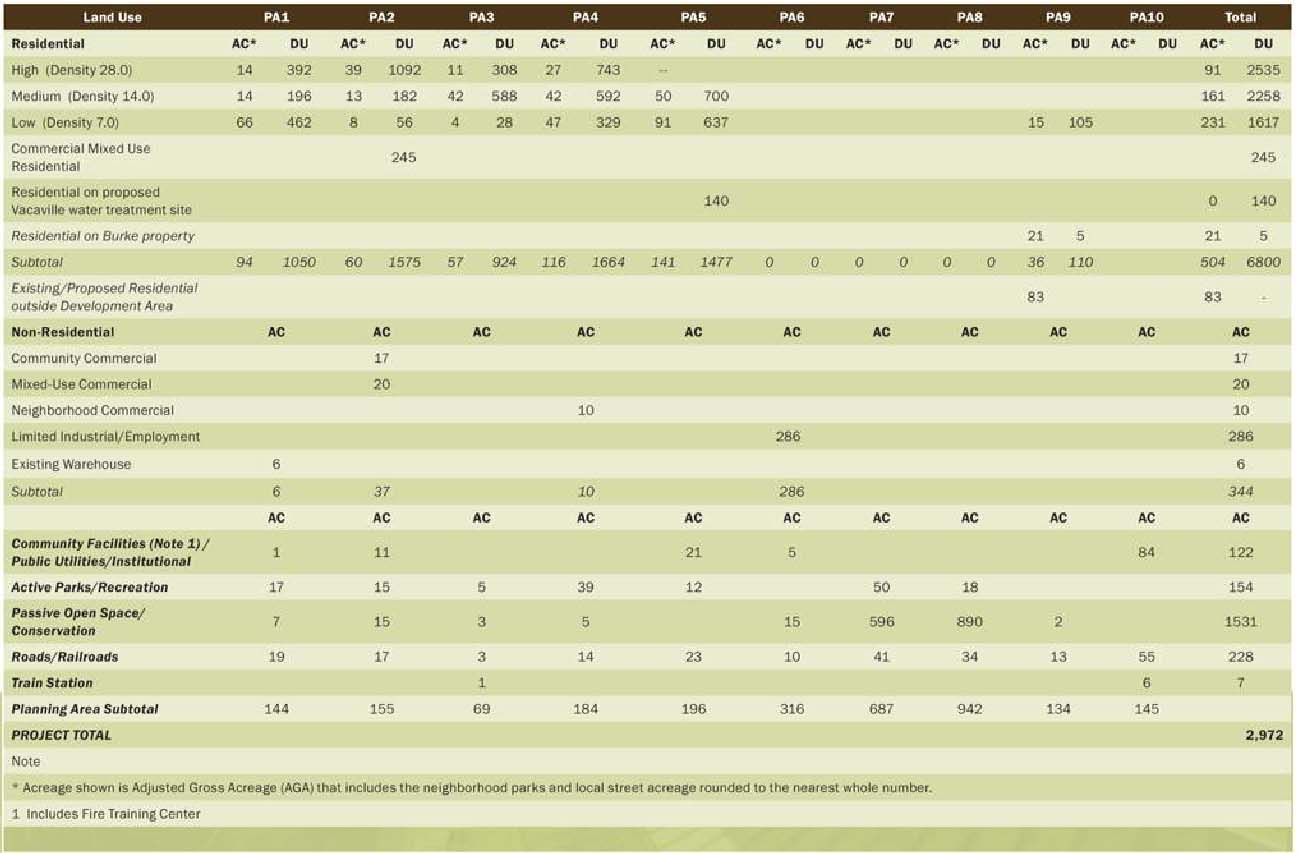 Table 4-1: Land Use Summary
5. Master Planned Unit Development Permit Required. Master Planned Unit Development Permits (MPUDP) shall be submitted to the Community Development Department for Specific Plan Planning Areas 1, 2, 3, 4, 5, and 6 (Figure 1) as depicted on Figure 4-7 of the Specific Plan. An application for an MPUDP may be submitted by any landowner or their representative. The City shall hold at least one meeting for landowners within the Planning Area prior to a public hearing on the MPUDP request. To approve the MPUDP, the Planning Commission must make findings that the MPUDP is consistent with the Train Station Specific Plan and this Zoning Ordinance.
Subsequent development in the Specific Plan Area will develop consistently with the initial MPUDP, unless amended and supplemented as required through the Project Level PUD process.
The MPUDP shall include the following elements:
A. Conceptual Land Plan depicting the location of various land uses, residential densities and housing types in the Planning Area. The Conceptual Land Plan shall determine the Adjusted Gross Acreage of each parcel and calculate the minimum and target number of residential units, based on its Specific Plan density.
B. Planning Area Facilities Plan. For each Planning Area designated in the Specific Plan (Figure 1), a Planning Area Facilities Plan (Facilities Plan) shall be prepared by qualified professionals and submitted to the Community Development Director for review.
1. Water. The Facilities Plan shall show domestic water source of water, storage and transmission facilities, and water distribution within the Planning Area, including connections to facilities serving the entire Specific Plan Area and other communities.
2. Streets and Pedestrian Facilities. The Facilities Plan shall show pedestrian and vehicular traffic flows and the location of streets and pedestrian facilities within the Planning Area, typical road cross sections within and contiguous to the Planning Area. The City shall require illustration of specific street improvements for each Planning Area consistent with the Specific Plan and Northeast Fee ordinance.
The locations of minor collector and local streets shown on Figure 4.1 in the Specific Plan are illustrative. The alignments of major collectors, arterial streets, and signalized intersections, including Peabody Road, New Canon Road, the Vanden Road/New Canon interchange, Cement Hill Road/Manuel Campos Parkway, and the Fairfield-Vacaville Train Station, shown on Figure 1-2 in the Specific Plan, shall be considered definitive.
3. Wastewater. The Facilities Plan shall identify collection and transmission facilities within the development area, including line sizes and capacities. The Facilities Plan should address connection to off-site City transmission facilities needed to serve the Planning Area.
4. Storm Drainage and Erosion Control. The Facilities Plan shall demonstrate compliance with the Specific Plan and all City of Fairfield and Fairfield-Suisun Sewer District requirements for storm drainage, including a master SWPP plan prepared for each planning area. Plans shall illustrate development area, sizing and location of storm drains and detention systems, and the location and design of the regional retention basins outlined in the Specific Plan. The Facilities Plan shall discuss the methodology for determining storm drainage flows and shall confirm that development will be flood-proofed from 100-year storms. The Facilities Plan shall also address erosion control during construction in compliance with all mitigation measures outlined in the Specific Plan EIR.
5. Parks. The Facilities Plan shall illustrate the location of all public parks of greater than 0.5 acres in size, public trails, public squares, and other major recreational facilities.
6. Other Public Utilities. The Facilities Plan shall show other major public utilities, including major power transmission corridors, regional water and wastewater infrastructure, and major telecommunications facilities. All utilities shall be placed underground unless specifically exempted by City Ordinance, State law, or identified in the Specific Plan.
C. Planning Area Community Design Plan. The purpose of the Planning Area Community Design Plan (Community Design Plan) is to implement the Specific Plan land use and design concepts and design guidelines and to establish consistent design themes for the Specific Plan area and each Planning Area. The Community Design Plan shall provide guidelines for property owners developing residential communities, commercial districts, and public spaces. The Community Design Plan should address major roadway corridors, community gateways, open space corridors, open space interfaces, parks, and parking lot location and design. The design concepts and themes in the Planning Area Community Design Plans should be consistent with the Specific Plan and the Planning Area Facilities Plan. The geographic boundaries of the initial Planning Area Community Design Plan shall include the entire Planning Area but should also illustrate how development in the Planning Area will integrate with surrounding development areas.
The initial Planning Area Community Design Plan anywhere in the Specific Plan Area will establish design themes and precedents for both the Planning Area and Master PUDs elsewhere in the Specific Plan Area. Subsequent Planning Area Community Design Plans and development proposals shall demonstrate consistency with the initial Planning Area Community Design Plan.
The Planning Area Community Design Plan shall include the following elements:
1. Conceptual Landscape Plan. Landscape Plans shall address neighborhood open space interfaces and corridors, walkways, public and private rights of way, street trees, public spaces and squares, public and private parks, entry features, sound wall landscaping, and landscape buffers between land uses.
2. Conceptual Open Space Plan. Open space is intended to be natural and undeveloped in character, providing for community buffers, habitat conservation and mitigation, and limited passive recreational uses. The Plan shall identify the location of the open spaces, proposed fencing, trees, shrubs, and other plantings, if proposed, access points, including fire roads, trails, natural features, including hill forms, trees (if any), drainage channels and associated riparian vegetation, rock formations, and creek corridors.
3. Special Design Elements. The Community Design Plan shall address the following design elements:
a. Fencing/wall plan which specifies height, location, design, and materials for fencing and/or walls.
b. Street furniture design, including ornamental streetlighting, mailboxes, benches, bollards and other decorative traffic control devices.
c. Community identification signs, monuments, or landscaped features.
d. Master Sign Program for all commercial and industrial areas.
D. Phasing Plan. The Master PUD Permit shall show the phasing of private development with the Planning Area and the phasing of construction of public improvements both within and outside of the Planning Area. This Phasing Plan shall be consistent with the provision of facilities outlined in the Master Facilities Plan.
E. Master Homeowners’ Association. Creation of a Master Homeowners’ Association (HOA) or annexation into an existing HOA shall be a condition of approval of any Master PUD Permit. All HOAs shall be established in accordance with the policies of the Specific Plan.
F. Multiple Ownerships. For Planning Areas having multiple ownerships at the time of the initial Master PUD Permit application, the Master PUD Permit shall be used by the City to determine:
1. Alignment of streets which traverse various parcels which have different owners;
2. Location of pocket parks, detention basins, and similar public or quasi-public facilities which serve that Planning Area;
3. Transfer of density within a Planning Area, if requested by property owners; and
4. Construction responsibilities for public improvements that benefit multiple property owners, including but not limited to detention basins, parks, streets located on existing property lines or which traverse or benefit more than one parcel, and utilities. Determination of construction responsibilities shall include cost sharing ratios and cost reimbursement obligations.
5. Compliance with Mitigation Monitoring Reporting Program. All development shall comply with the mitigation measures contained in the Mitigation Monitoring and Reporting Program, adopted by the City Council by Resolution 2011-158, in conjunction with its certification of the Final Environmental Impact Report for the Specific Plan. If subsequent environmental review is done for a project in accordance with the California Environmental Quality Act, then it also shall comply with any mitigation measures approved as part of the subsequent environmental review.
B. Conditional Use Permits.
“Conditional Use” refers to uses permitted at the discretion of the Planning Commission or the Community Development Director. In granting a Conditional Use Permit or a Planned Unit Development Permit approving a conditional use, the Commission or Director shall make all findings required in Section 25.40.6 of the Zoning Ordinance.
C. Project Planned Unit Development Permits.
Development consistent with an existing Master Planned Unit Development Permit and this Ordinance shall not generally require a project-level Planned Unit Development Permit. However, a Project Planned Unit Development Permit shall be required in the following circumstances:
1. If an applicant proposes to modify an existing Master Planned Unit Development Permit.
2. If a project requires a change in density or development type from that identified in the Specific Plan.
3. If an applicant proposes to deviate from development standards for allowed base zoning in this Zoning Ordinance.
4. If the applicant proposes an amendment to the Specific Plan.
5. If the project is located in Planning Area 2 and is not a Low Density Residential Land Use and for uses in the Village Core in Planning Area 4.
6. If the project is a mixed-use commercial-residential project.
D. Specific Planning Area Development Regulations.
All development in the Train Station Specific Plan shall comply with the goals, policies, and development guidelines contained in the Train Station Specific Plan document and the associated Environmental Impact Report.
1. Planning Area 1. Development in Planning Area 1 shall be subject to the following regulations:
A. Maximum Dwelling Units. A maximum of 1,050 dwelling units may be developed in Planning Area 1. Applicants may request additional units through a density transfer via the Planned Unit Development Permit process outlined in Section 4.A.4 above.
B. Land Use Regulations.
1. Permitted Uses. For areas designated as follows on Figure 1-2 of the Specific Plan:
a. LR: Uses permitted in Table 25-1 of the Fairfield Zoning Ordinance for the RLM Zoning District, but including home occupation and live-work.
b. MR: Uses permitted in Table 25-1 of the Fairfield Zoning Ordinance for the RM and RH Zoning Districts but including home occupation and live-work.
c. HR: Uses Permitted in Table 25-1 of the Fairfield Zoning Ordinance for the RH and RVH Zoning Districts, but including home occupation and live-work.
d. For Park and Linear Park sites, all uses in Table 25-13 of the Fairfield Zoning Ordinance for the REC Land Use.
e. Warehouse (existing): Permitted to remain as a mini-warehouse as defined in the Fairfield Zoning Ordinance.
2. Prohibited Uses.
a. New mini warehouse facilities.
b. All office uses except for property management.
3. Development Regulations. For areas designated as follows on Figure 1-2 of the Specific Plan:
a. LR: Comply with the standards for RL8, RLM6, RLM5, RL4.5 or RLM/RM Small Lot zoning districts in Tables 25-3 and 25-5 of the Fairfield Zoning Ordinance.
b. MR: Comply with the standards for RM Small Lot or Multifamily Development Standards (RM/RH) as contained in Tables 25-4, 25-5 or 25-6 of the Fairfield Zoning Ordinance.
c. HR: Comply with the standards for RH or RVH development in Table 25-4 of the Fairfield Zoning Ordinance, subject to design consistency with the Specific Plan except that development may occur at densities of up to 50 dwelling units per acre as provided for in the Specific Plan.
d. Park sites and Linear Park: Subject to the requirements of Table 25-13 of the Fairfield Zoning Ordinance for REC.
e. The City may require additional walls or landscaping to screen residential uses from existing nonconforming land uses.
2. Planning Area 2. Development in Planning Area 2 shall be subject to the following regulations:
A. Maximum Development. A maximum of 1,575 dwelling units and 37 acres of Community Commercial and Mixed Use Commercial development may be developed in Planning Area 2, along with community facilities, active parks and recreation areas, and passive open space areas. Applicants may request additional residential units through a density transfer via the Planned Unit Development Permit process outlined in Section 4.A.4 above.
B. Land Use Regulations.
1. Permitted Uses. For areas designated as follows on Figure 1-2 of the Specific Plan:
a. LR: Uses permitted in Table 25-1 of the Fairfield Zoning Ordinance for the RLM Zoning District but including home occupations and live-work.
b. MR: Uses permitted in Table 25-1 of the Fairfield Zoning Ordinance for the RM and RH Zoning Districts, but including home occupations and live-work.
c. HR: Uses Permitted in Table 25-1 of the Fairfield Zoning Ordinance for the RH and RVH Zoning Districts but including home occupations and live-work.
d. Community Commercial: Uses permitted for the HD and CN Zoning Districts as defined in this Ordinance.
e. Commercial Mixed Use: Uses permitted for the HD, CN, and CM Zoning Districts as defined in this Ordinance.
f. For Park and Linear Park sites: Uses in Table 25-13 of the Fairfield Zoning Ordinance for the REC Land Use, except as required to implement the concept for the Town Square outlined in the Specific Plan.
g. School: Uses permitted include all uses in Table 25-13 of the Fairfield Zoning Ordinance for “PF” Public Facilities land uses.
2. Prohibited Uses.
a. Mini-warehouse facility.
b. In areas designated LR, HR and MR, all office uses except for on site residential leasing or sales offices.
3. Development Regulations. For areas designated as follows on Figure 1-2 of the Specific Plan:
a. With the exception of LR housing, School facilities, residential additions and accessory structures, all development in Planning Area 2 residential requires a Project Planned Unit Development Permit to ensure that such development implements the design and land use concepts for the Town Center outlined in Chapter 5 of the Train Station Specific Plan.
b. LR: Comply with the standards for RL8, RLM6, RLM5, RL4.5 or RLM/RM Small Lot as contained in Tables 25-3 or 25-5 of the Fairfield Zoning Ordinance.
c. MR: Except where necessary to implement the Specific Plan Town Center design concept, comply with the standards for RM Small Lot or Multifamily Development Standards (RM/RH) as contained in Tables 25-4, 25-5, or 25-6 of the Fairfield Zoning Ordinance and a Planned Unit Development Permit.
d. HR: Except where necessary to implement the Specific Plan Town Center design concept, the two areas designated HR opposite the Train Station site shall comply with the standards for RVH development in Table 25-4 or 25-6 of the Fairfield Zoning Ordinance, except that development shall occur at densities of at least 24 dwelling units per acre. Development may occur at densities of up to 50 dwelling units per acre as provided for in the Specific Plan subject to design consistency with the Specific Plan and a Planned Unit Development Permit.
Other areas designated RH shall comply with the standards for either RH or RVH development, as appropriate for their proposed development density, in Table 25-4 except that development may occur at densities of up to 50 dwelling units per acre as provided for in the Specific Plan.
e. Community Commercial: Development shall occur subject to the requirements of CDC and CN Zoning Districts except as modified by this Specific Plan.
f. Commercial Mixed Use: Development shall occur subject to the requirements of the Zoning Ordinance for the CM, CDC and CN Zoning Districts except as modified by this Specific Plan.
g. For Park and Linear Park sites: Development shall occur per the design concepts contained in the Specific Plan as required to implement the concept for the Town Square and other public and private open space and recreational amenities.
h. School: School design shall implement the vision of the Specific Plan.
3. Planning Area 3. Development in Planning Area 3 shall be subject to the following regulations:
A. Maximum Dwelling Units. A maximum of 924 dwelling units may be developed in Planning Area 3. Applicants may request additional residential units through a density transfer via the Planned Unit Development Permit process outlined in Section 4.A.4 above.
B. Land Use Regulations.
1. Permitted Uses. For areas designated as follows on Figure 1-2 of the Specific Plan:
a. LR: Uses permitted in Table 25-1 of the Fairfield Zoning Ordinance for the RLM Zoning District, but including home occupation and live-work.
b. MR: Uses permitted in Table 25-1 of the Fairfield Zoning Ordinance for the RM and RH Zoning Districts but including home occupation and live-work.
c. HR: Uses permitted in Table 25-1 of the Fairfield Zoning Ordinance for the RH and RVH Zoning Districts, but including home occupation and live-work.
d. For Park and Linear Park sites: All uses in Table 25-13 of the Fairfield Zoning Ordinance for the REC Land Use.
2. Prohibited Uses.
a. Mini warehouse facilities.
b. All office uses except for property management.
3. Development Regulations. For areas designated as follows on Figure 1-2 of the Specific Plan:
a. LR: Comply with the standards for RL8, RLM6, RLM5, RL4.5 or RLM/RM Small Lot as contained in Tables 25-3 or 25-5 of the Fairfield Zoning Ordinance.
b. MR: Comply with the standards for RLM/RM Small Lot or Multifamily Development Standards (RM/RH) as contained in Tables 25-4 and 25-5 of the Zoning Ordinance.
c. HR: Comply with the standards for RH or RVH development in Table 25-4 or 25-5 of the Fairfield Zoning Ordinance, subject to design consistency with the Specific Plan except that development may occur at densities of up to 50 dwelling units per acre as provided for in the Specific Plan.
d. Park sites and Linear Park: Subject to the requirements of Table 25-13 of the Fairfield Zoning Ordinance for REC.
e. Pedestrian connections and train station drop-off shall be provided as outlined in the Specific Plan policies for Planning Area 3.
4. Planning Area 4. Development in Planning Area 4 shall be subject to the following regulations:
A. Maximum Dwelling Units. A maximum of 1,664 dwelling units may be developed in Planning Area 4. Applicants may request additional residential units through a density transfer via the Planned Unit Development Permit process outlined in Section 4.A.4 above.
B. Land Use Regulations.
1. Permitted Uses. For areas designated as follows on Figure 1-2 of the Specific Plan:
a. In residential areas: Except for those uses identified in subsection 2 below as “prohibited uses,” all uses in Table 25-1 of the Fairfield Zoning Ordinance for the RL, RLM, RM, RH and RVH Zoning Districts, including single family residential, multifamily residential and accessory and ancillary uses, as appropriate for the density identified in the Specific Plan.
b. South Lake Activity Core, as described in Chapter 5 of the Specific Plan: Permitted Uses include those listed as permitted in Table 25-9 for the CN Zoning District. In addition, the following specific land uses may be conditionally permitted in the South Lake Activity Core:
• public library
• entertainment with food service
• bar
c. Lake Park: For park sites, all uses in Table 25-13 for the REC land use.
2. Prohibited Uses.
a. Mini warehouse facilities.
b. In the LR, HR and MR land use districts, all office uses except for residential management offices.
3. Development Regulations. In addition to the specific design guidelines established in Chapter 6 (Lake District Plan), development shall comply with the following regulations. For areas designated as follows on Figure 1-2 of the Specific Plan:
a. LR: Comply with the standards for RL8, RLM6, RLM5, RL4.5, RLM/RM Small Lot as contained in Tables 25-3 or 25-5 of the Fairfield Zoning Ordinance.
b. MR: Comply with the standards for RM Small Lot or Multifamily Development Standards (RM/RH) as contained in Tables 25-4, 25-5, or 25-6 of the Fairfield Zoning Ordinance.
c. HR: Comply with the standards for RH or RVH development in Table 25-4 of the Fairfield Zoning Ordinance, subject to design consistency with the Specific Plan except that development may occur at densities of up to 50 dwelling units per acre as provided for in the Specific Plan.
d. Park sites and Linear Park: Should be developed in accordance with Table 25-13 of the Fairfield Zoning Ordinance where appropriate. The Lake Park shall be developed in accordance with Figure 6-1 and Section 6.4.1 of the Specific Plan.
e. Village Core (Neighborhood Commercial): Development shall generally comply with the requirements of the CN Zoning District except where specific policies and design guidelines for development contained in Chapter 6 of the Specific Plan provide additional guidelines.
f. The following items shall be submitted with the Master PUD Permit for Planning Area 4:
i. A Storm Water Reuse Plan in accordance with Specific Plan Policy 11-14.
ii. A Lake Management Plan in accordance with Specific Plan Policy 11-13.
iii. Conceptual land plan for the 20-acre CN parcel, in accordance with Specific Plan Policy 6-14.
iv. Lake Park Master Plan, including the phasing of its improvements, in accordance with Specific Plan Policies 6-25 and 6-27.
5. Planning Area 5. Development in Planning Area 5 shall be subject to the following regulations:
A. Maximum Dwelling Units. A maximum of 1,447 dwelling units may be developed in Planning Area 5. Applicants may request additional residential units through a density transfer via the Planned Unit Development Permit process outlined in Section 4.A.4 above.
B. Land Use Regulations.
1. Permitted Uses. For areas designated as follows on Figure 1-2 of the Specific Plan:
a. LR: Uses permitted in Table 25-1 of the Fairfield Zoning Ordinance for the RLM Zoning District, but including home occupation and live-work.
b. MR: Uses permitted in Table 25-1 of the Fairfield Zoning Ordinance for the RM and RH Zoning Districts but including home occupation and live-work.
c. Water Treatment Plant: Subject to Policy 4-14 I through III in the Train Station Specific Plan.
2. Prohibited Uses.
a. Mini warehouse facilities.
b. All office uses except for property management.
3. Development Regulations. For areas designated as follows on Figure 1-2 of the Specific Plan:
a. LR: Areas south of New Canon Road shall comply with the standards for RLM6, RLM5, RL4.5 or RLM/RM Small Lot as contained in Tables 25-3 or 25-5 of the Fairfield Zoning Ordinance. Areas north of New Canon road shall comply with the standards for the RL10 or RL8 as contained in Tables 25-2 or 25-3 of the Fairfield Zoning Ordinance.
b. MR: Comply with the standards for RLM/RM Small Lot or Multifamily Development Standards (RM/RH) as contained in Tables 25-4 and 25-5 of the Fairfield Zoning Ordinance.
c. City may require additional setbacks or screening for residential development adjacent to the potential Vacaville Water Treatment Plant.
d. The following items shall be submitted with the Master PUD Permit for Planning Area 5:
i. Plan showing access to the 20-acre site owned by the City of Vacaville for a future water treatment plant, in accordance with Specific Plan Policy 4-14.
ii. The Master PUD Permit for PA 6 shall be submitted concurrently with the Master PUD Permit for PA 5.
iii. The Master PUD Permit for PA 7 shall be submitted concurrently with the Master PUD Permit for PA 5. The Master PUD Permit for PA 7 shall include a Conceptual Plan for the Great Park and any trail or open space improvements within PA 7.
6. Planning Area 6. Development in Planning Area 6 shall be subject to the following regulations:
A. Maximum Development. A maximum of 286 acres may be developed for industrial purposes in Planning Area 6. Up to 14 acres may be developed for limited service uses and as provided for in the specific plan.
B. Permitted Uses.
1. Permitted uses shall be those permitted in the IL (Limited Industrial) Zoning District (Table 25-11) for the southern subarea and for the portion of the northern subarea north of New McCrory Road.
2. Permitted uses in the northern subarea south of New McCrory Road shall be those permitted in the IG (General Industrial) or IL Zoning Districts.
3. A limited-scale service area consisting of professional offices, food service, fitness, business support services, personal services, and/or medical uses may be permitted in each subarea, subject to the development standards of the CN (Neighborhood Commercial) Zoning District and the approval of the Community Development Director or the Planning Commission.
4. In addition to those uses permitted by subsections 1-3 above, any industrial use within the Train Station Specific Plan area, which was legally established under County jurisdiction and in existence at the time of annexation but which became a nonconforming use due to annexation to the City, shall be classified as a permitted use in Planning Area 6, subject to the following provisions:
a. The relocation of such use to Planning Area 6 shall be subject to City’s development review process; City shall have the right to impose conditions of approval in accordance with all adopted policies and standards of the City, including the Specific Plan. Those conditions of approval may include but are not limited to building design, building height and location, hours of operation, lighting and noise standards, screening of outdoor storage, and operational aspects of the use.
b. City may but is not obligated to approve a relocation of an existing nonconforming use to Planning Area 6, which would have a larger site area, larger building area, or greater intensity of industrial operations than exist at the time of annexation.
C. Rail Service. One or more railroad spurs shall be constructed by the landowners to serve industrial development in Planning Area 6. The timing, location, and extent of the railroad spurs shall be reviewed and approved by the City during the Master Planned Unit Development Permit for Area 6.
D. Development Standards.
1. With the exceptions listed below, development shall be constructed per the standards for industrial development (IL and IG) in Table 25-12. Commercial development shall meet the standards contained in Table 25-10 for CN development.
2. Industrial development visible from Vanden Road shall incorporate screening landscaping and/or buffering berms to reduce visual impacts from outdoor storage areas and delivery and service areas.
3. Industrial properties which abut habitat conservation areas shown on Figure 12-4 in the Specific Plan shall also meet the following standards:
a. Maintain a minimum 20-foot setback to any building, streets, or landscape elements permitted within this setback.
b. Locate loading, waste disposal, heavy equipment, and parking for large trucks away from these edges.
c. Comply with requirements for habitat conservation “edges” outlined in Section 12.4 of the Specific Plan.
7. Planning Area 9. Development in Planning Area 9 shall be subject to the following regulations:
A. Maximum Development. For Planning Area 9A, refer to the existing North Gate Planned Development Zoning (Z.C.-88-15).
Planning Area 9B can be developed with up to 5 single family dwellings on minimum one-acre lots. If property owners wish to receive water and/or sewer service from the City of Fairfield, they will be responsible for constructing all utilities, paying all reimbursements, impact fees and connection fees, and annexing into any Community Facilities Districts formed by property owners in the remainder of the Train Station Specific Plan Area.
Planning Area 9D can be developed with up to 105 single family homes. Applicants may request additional residential units through a density transfer via the Planned Unit Development Permit process outlined in Section 4.A.4 above.
B. Land Use Regulations.
1. Permitted Uses.
For Planning Area 9A, please refer to the North Gate Planned Development Zoning (Z.C. 88-15).
Land Uses in Planning Area 9B shall be limited to those uses permitted in the RVL zoning district. Land Uses in Planning Area 9D shall be limited to those uses permitted in the RLM Zoning District.
2. Development Regulations.
For Planning Area 9A, please refer to the North Gate Planned Development Zoning. Development in Planning Area 9B shall comply with all standards for RVL 1 development in Table 25-2. Development in Planning Area 9D shall comply with the standards for RLM6, RLM5, RL4.5, or RLM/RM Small Lot zoning districts in Table 25-3 and 25-4 of the Fairfield Zoning Ordinance.
E. Nonconforming Uses. Notwithstanding any provisions of the Zoning Ordinance of the City of Fairfield, the following provisions shall regulate those uses which are not consistent with the land use designations of the Train Station Specific Plan and the Train Station Specific Plan Planned Development Overlay Zone District.
1. A use which had been legally established in an unincorporated area under Solano County jurisdiction as a permitted use or through a land use permit with a condition of approval without an expiration date, and which is in existence at the time of its annexation to the City shall become a legal nonconforming use. All such nonconforming uses shall have the right to continue to operate subject to compliance with the conditions of approval adopted by the County and shall be subject to the nonconforming use and structure provisions of Section 25.46 of the Zoning Ordinance of the City of Fairfield.
2. A use which is in existence at the time of its annexation and which had been legally established in an unincorporated area under Solano County jurisdiction through a land use permit with a condition of approval with an expiration date, shall have the right to continue to operate during the term of its County permit as a legal nonconforming use. All such nonconforming uses shall have the right to continue to operate subject to compliance with the conditions of approval adopted by the County and shall be subject to the nonconforming use and structure provisions of Section 25.46 of the Zoning Ordinance of the City of Fairfield. Upon expiration of the term of the land use permit, the use shall have no legal right to continue to operate and shall cease operation on the date of expiration of its term.
Notwithstanding the above, the City may allow such use to continue after annexation as an interim use subject to the Final Approval of an interim use permit subject to the requirements as follows:
a. Property owner files an application for an interim use permit in accordance with the provisions of Section F below within one year of the effective date of Ordinance 2023-04.
b. Property owner agrees to make an irrevocable offer of dedication of the abutting right-of-way if the property abuts Cement Hill Road, Peabody Road and or Vanden Road.
c. Provisions to guarantee the termination of the use upon expiration of the interim use permit.
3. A use in existence at the time of its annexation to the City and which had been legally established under Solano County jurisdiction through a land use permit with a condition of approval which causes the permit to expire or become null and void upon annexation to the City, shall be subject to the following regulations:
a. Each use shall have the legal right to continue to operate in accordance with its County land use permit conditions for a period of one year after the date of annexation to the City.
b. Within one year of the effective date of Ordinance 2023-04, each property owner and permittee with an expiring or expired county land use permit must file an Interim Use Permit application with the City.
c. Any use which does not obtain approval of its interim use permit application shall have no legal right to continue to operate and shall cease operation.
4. A use in existence at the time of annexation which was not legally established under Solano County jurisdiction shall not be classified as a legal, nonconforming use and shall have no rights to continue to operate pursuant to this section. Any continuation of such use subsequent to annexation to the City shall be in violation of the Zoning Ordinance and the Train Station Specific Plan Planned Development Overlay Zone District Ordinance. All such uses shall cease immediately upon annexation to the City.
Notwithstanding the above, the City may allow such use to continue after annexation as an interim use subject to the Final Approval of an interim use permit subject to the requirements as follows:
a. Property owner files an application for an interim use permit in accordance with the provisions of Section F below within one year of the effective date of Ordinance 2023-04.
b. Property owner agrees to make an irrevocable offer of dedication of the abutting right-of-way if the property abuts Cement Hill Road, Peabody Road and or Vanden Road.
c. Provisions to guarantee the termination of the use upon expiration of the interim use permit.
5. If a use was not legally established or is operating in violation of the Solano County Zoning Ordinance, notwithstanding the provisions of subsection 4 above, the City may allow such use to continue, or be introduced, after annexation as an interim use subject to the Final Approval of an interim use permit, provided the owner of property and the City have entered into a settlement agreement or similar agreement. The terms of such agreement shall include but are not limited to the following:
a. Property owner agrees to file an application for an interim use permit in accordance with the provisions of Section F.
b. Property owner agrees to make an irrevocable offer of dedication of the abutting right-of-way if the property abuts Cement Hill Road, Peabody Road and or Vanden Road.
c. Provisions to guarantee the termination of the use upon expiration of the interim use permit.
d. For nonconforming uses that are introduced on an interim basis, property owner agrees to make an irrevocable offer of dedication for internal streets and detention basins as depicted in Figure 1-2 of the Train Station Specific Plan or any approved Master Planned Unit Development Permit that includes the subject property.
F. Interim Land Uses.
1. Purpose. The Train Station Specific Plan area contains existing uses established under Solano County jurisdiction which are not consistent with the land uses allowed by the Specific Plan. The purpose of this section is to allow those nonconforming uses to continue or be introduced for a limited duration following annexation, or similar uses otherwise not permitted by the Specific Plan, provided they will not impede development of land uses allowed by the Train Station Specific Plan.
2. Interim Use Permit. An interim use permit is a discretionary permit which, if approved, would allow the continued operation and limited expansion of nonconforming uses, or similar uses otherwise not permitted, which would otherwise be required to cease operation upon annexation to the City. A property owner is eligible to apply for an interim use permit only if the property meets the criteria in Subsection E.3 or E.5 above.
3. Application Requirements. The application contents and application fee shall be those in effect for a Conditional Use Permit, in accordance with Section 25.41.3 and 25.41.4 of the Fairfield Zoning Ordinance.
4. Approval Authority. An interim use permit shall be subject to approval of the Community Development Director. Notice of pending consideration of an interim use permit shall be provided in the same manner as a Conditional Use Permit.
5. Preliminary Approval.
a. A granting of Preliminary Approval of an interim use permit by the Community Development Director shall contain conditions of approval which include but are not limited to the following:
i. No site improvements shall be allowed except those required to comply with a condition of approval of an interim use permit.
ii. Conditions related to the use of the property and operational characteristics, including but not limited to intensity of the use, hours of operation, lighting, noise, and vehicular access.
iii. If the property abuts Cement Hill Road, Peabody Road and or Vanden Road, the property owner shall make an irrevocable offer of dedication to the City of the additional right-of-way along its frontage which is needed to widen the road in accordance with the standards of Chapter 10 of the Specific Plan.
iv. The duration of the interim use permit.
v. An agreement between the City and the property owner and the interim use permit applicant which includes provisions to guarantee the termination of the use upon expiration of the interim use permit.
b. The Community Development Director may grant a Preliminary Approval of an interim use permit if the Director finds and determines that:
i. The continuation or introduction of the interim use during the duration of the interim use permit will not impede the development of other properties in the vicinity in accordance with the Specific Plan;
ii. The prevailing economic conditions do not support development of the property in accordance with the Specific Plan, during the duration of the interim use permit; and
iii. The conditions of approval related to the use of the property and its operational characteristics will not impede the development of other properties in the vicinity in accordance with the Specific Plan or affect the health, safety and welfare of residents or businesses in the vicinity.
6. Final Approval. The Community Development Director shall grant Final Approval of a preliminary interim use permit when he/she determines that the permittee and property owner have complied with all the conditions of approval of the Preliminary Approval.
7. Interim Use Permit Term and Extension.
a. The term of an interim use permit shall be determined through the conditions of Preliminary Approval. The duration of the term shall be determined by Community Development Director, based on the findings in subsection 5.b above.
b. The minimum initial term of an interim use permit shall be one year.
c. A permittee and property owner may file an application to extend the term of an interim use. A request for extension shall be processed in the same manner as an interim use permit application and subject to the same findings.
8. Revocation. If the Community Development Director determines that a use is not operating in compliance with the conditions of approval of its interim use permit, he/she shall provide to the property owner and permittee a written notice of intent to revoke the interim use permit. The written notice shall be sent not less than ten (10) calendar days prior to the date of the administrative hearing. At the conclusion of the hearing, the Community Development Director may revoke or modify the conditions of approval of the interim use permit if the Director finds that the use is not operating in compliance with the conditions of approval.
L. Green Valley Residential.* The following development standards shall apply in the Green Valley Residential PD overlay district:
|
1. |
Lot Dimensions: |
|||
|
|
Width |
|||
|
|
|
Interior lot |
38 feet |
|
|
|
|
Corner lot |
43 feet |
|
|
|
Depth |
83 feet |
||
|
2. |
Parking: |
|||
|
|
|
On-site spaces per dwelling |
2 covered, 2 uncovered |
|
|
|
|
Off-site spaces per dwelling |
1 uncovered |
|
|
3. |
Landscaping: |
|||
|
|
|
Street trees (one tree for each) |
25 feet of street frontage, planted within 8 feet of back of sidewalk |
|
|
|
|
Front yard landscaping to be installed by developer |
||
|
4. |
Open Space: |
|||
|
|
|
Private open space |
450 square feet |
|
|
|
|
Common open space |
5% of net project area |
|
|
5. |
Dwelling Unit Size: |
960 square feet |
||
|
6. |
Lot Coverage: |
60% |
||
|
7. |
Setbacks: |
|
||
|
|
|
Front |
|
|
|
|
|
|
Habitable portion of building |
15 feet |
|
|
|
|
Porch |
10 feet |
|
|
|
|
Garage opening |
18 feet |
|
|
|
Street side yard |
10 feet |
|
|
|
|
Interior side yard |
3-1/2 feet |
|
|
|
|
Rear |
5 feet |
|
|
8. |
Building Height Limits: |
|||
|
|
|
Main dwelling |
35 feet |
|
|
|
|
Accessory structures |
see §25.20.4.1 |
|
(Ord. No. 2010-03, § 2; Ord. No. 2011-11, §§ 5, 6; Ord. No. 2012-13, § 4; Ord. No. 2013-16, § 2; Ord. No. 2015-06, § 2; Ord. No. 2015-16, § 3; Ord. No. 2017-08, § 2; Ord. No. 2018-03, § 8; Ord. No. 2019-04, § 8; Ord. No. 2020-18, §§ 2, 3; Ord. No. 2021-14, §§ 11, 12; Ord. No. 2023-04, § 9.)
* Code reviser’s note: Ord. No. 2015-16 adds these provisions as subsection M. They have been editorially relettered to avoid a gap in lettering.