


Chapter 17.240
WATERFRONT HERITAGE DISTRICT
Sections:
17.240.020 Waterfront heritage district zoning subdistricts.
17.240.050 Uses expressly prohibited.
17.240.055 Land uses and permit requirements.
17.240.070 Property development requirements.
17.240.080 Architectural design.
17.240.010 Purpose.
The waterfront heritage district (WH) district is created to achieve the following objectives:
(1) To diversify the local economy.
(2) To preserve the city’s historical waterfront and guide private and public development in a direction that strengthens a relationship to that setting.
(3) To guide the construction of private and public improvements to evoke historic architectural styles which existed in the Coos Bay area between the 1870s and the 1920s.
(4) To provide for a mix of uses and improvements that include:
(a) Existing waterfront industrial uses;
(b) New water-oriented, water-related and non-water-related service businesses;
(c) Amenities and attractions which encourage public access to and enjoyment of the waterfront;
(d) Urban residential opportunities; and
(e) Non-water-dependent industrial uses.
(5) To provide an opportunity to reclaim the city’s waterfront heritage and express pride in our past and present by redevelopment which evokes, but does not necessarily duplicate, the appearance of the early days of Euro-American settlement.
(6) To promote physical, cultural and commercial links among Front Street, the boardwalk and the downtown core area.
(7) To ensure that there is safe, interconnected, and multimodal transportation access to and within development sites.
(8) To accommodate pedestrian connectivity to and along the Coos Bay waterfront. [Ord. 541 § 6 (Exh. 1), 2021; Ord. 526 § 5 (Exh. D), 2020; Ord. 503 § 1 (Exh. B), 2018; Ord. 473 § 3 (Exh. A), 2016].
17.240.020 Waterfront heritage district zoning subdistricts.
The WH district shall be made up of three zoning subdistricts defined as follows:
(1) WH-1, Core Area. The area bounded by Alder Avenue to the south, U.S. 101 (North Bayshore) to the west, Date Avenue to the north and the Coos Bay waterway to the east.
(2) WH-2, Transition Area. The area bounded by Commercial Avenue to the south, U.S. 101 (North Bayshore) to the west, Fir Avenue to the north, and the Coos Bay waterway to the east, except that area defined as WH-1.
(3) WH-3, Central Dock Area. The area bounded by Fir Avenue on the south, U.S. 101 (North Bayshore) to the west, Ivy Avenue to the north and the Coos Bay waterway to the east. [Ord. 541 § 6 (Exh. 1), 2021; Ord. 503 § 1 (Exh. B), 2018; Ord. 473 § 3 (Exh. A), 2016].
17.240.030 Permitted uses.
The following are permitted uses in the WH district:
(1) For those areas lying east of Front Street, including the WH-3 subdistrict, all commercial, industrial, and civic uses which are water-dependent or water-related are permitted as allowed by the Coos Bay estuary management plan.
(2) Uses which are not water-dependent or water-related are permitted as set forth in Table 17.240.055. [Ord. 541 § 6 (Exh. 1), 2021; Ord. 503 § 1 (Exh. B), 2018; Ord. 473 § 3 (Exh. A), 2016].
17.240.040 Conditional uses.
The following uses are permitted in the WH district if authorized in accordance with the provisions of Chapter 17.347 CBDC, Conditional Uses:
(1) Civic use types as defined in Chapter 17.150 CBDC.
(2) Commercial Use Types.
(a) Business equipment sales and service.
(b) Repair service, consumer.
(c) Tourist habitation – waterfront inn, WH-2 and WH-3 subdistricts only.
(3) Industrial Use Types. Manufacturing, WH-3 subdistrict only.
(4) Horticulture use types as defined in Chapter 17.150 CBDC. [Ord. 541 § 6 (Exh. 1), 2021; Ord. 503 § 1 (Exh. B), 2018; Ord. 473 § 3 (Exh. A), 2016].
17.240.050 Uses expressly prohibited.
The following uses are expressly prohibited in the WH district:
(1) Civic Use Types.
(a) Educational service.
(2) Commercial Use Types.
(a) Automobile and Equipment.
(i) Cleaning.
(ii) Fleet storage.
(iii) Repairs, light and heavy equipment.
(iv) Sales/rental, light and heavy equipment, except boats.
(v) Storage, nonoperating vehicles.
(b) Agricultural sales/services.
(c) Building/property maintenance service.
(d) Fuel sales, other than marine.
(e) Transportation services, except rail and marine.
(f) All marijuana related businesses. [Ord. 553 § 3, 2022; Ord. 550 § 1, 2022; Ord. 541 § 6 (Exh. 1), 2021; Ord. 503 § 1 (Exh. B), 2018; Ord. 473 § 3 (Exh. A), 2016].
17.240.055 Land uses and permit requirements.
Land uses and permit requirements are listed in Table 17.240.055. The table identifies those uses in the waterfront heritage district that are:
P = Permitted use;
C = Conditional use;
S = Permitted uses that are subject to special standards; or
X = Prohibited use.
The applicable procedural requirements are found in Chapter 17.130 CBDC.
|
Use |
WH-1 Core Area |
WH-2 Transition Area |
WH-3 Central Dock Area |
|||
|---|---|---|---|---|---|---|
|
Ground Level |
Upper Level |
Ground Level |
Upper Level |
Ground Level |
Upper Level |
|
|
Residential Uses |
||||||
|
Dwelling, single-unit |
|
P |
|
P |
|
P |
|
Dwelling, duplex |
|
P |
|
P |
|
P |
|
Dwelling, multi-unit |
|
P |
|
P |
|
P |
|
Townhouse |
|
|
P |
P |
P |
P |
|
Civic Uses |
||||||
|
Administrative service |
|
P |
P |
P |
P |
P |
|
Community recreation |
P |
P |
P |
P |
P |
P |
|
Library service and cultural exhibit |
P |
P |
P |
P |
P |
P |
|
Lodge, club, fraternal or civic assembly – Small and large |
|
P |
|
P |
|
P |
|
Public safety service |
P |
P |
P |
P |
P |
P |
|
Visitor information center |
P |
|
P |
|
P |
P |
|
Commercial Uses |
||||||
|
Business support service |
|
P |
P |
P |
P |
P |
|
Child care facility (fewer than 13), accessory to permitted use |
|
P |
P |
P |
P |
P |
|
Clinic |
|
P |
|
P |
|
P |
|
Convenience sales and personal services |
P |
P |
P |
P |
P |
P |
|
Dining establishments – Fast order food and sit-down |
P |
P |
P |
P |
P |
P |
|
Drive-in or drive-through facility compliant with the requirements of CBDC 17.335.070 |
P |
X |
P |
X |
P |
X |
|
Farmer’s market/fish market |
P |
P |
P |
P |
P |
P |
|
Financial, insurance and real estate services |
P |
P |
P |
P |
P |
P |
|
Food and beverage retail sales |
P |
P |
P |
P |
P |
P |
|
Fuel sales – Marine |
P |
|
P |
|
P |
|
|
Galleries |
P |
P |
P |
P |
P |
P |
|
Manufacturing, limited, which provides public viewing of on-site production and retail sales of finished products |
P |
P |
P |
P |
P |
P |
|
Market place retail sales |
P |
P |
P |
P |
P |
P |
|
Parking services – Prohibited east of Front St. except in WH-3 |
P |
P |
P |
P |
P |
P |
|
Participant sports and recreation – indoor and outdoor |
P |
P |
P |
P |
P |
P |
|
Personal services – General |
P |
P |
P |
P |
P |
P |
|
Postal service |
P |
|
P |
|
P |
|
|
Professional and administrative services |
P |
P |
P |
P |
P |
P |
|
Retail sales – General (less than 10,000 sq. ft. building) |
P |
P |
P |
P |
P |
P |
|
Spectator sports and entertainment – Indoor and outdoor |
P |
P |
P |
P |
P |
P |
|
Tourist habitation – Waterfront heritage bed and breakfast |
P |
P |
P |
P |
P |
P |
|
Transportation service – Rail and marine only |
P |
P |
P |
P |
P |
P |
|
Watercraft sales/rentals |
P |
|
P |
|
P |
|
|
All marijuana related businesses |
X |
X |
X |
X |
X |
X |
|
Other similar uses deemed by the director to be compatible with the MP district and adjacent land uses |
P |
P |
P |
P |
P |
P |
[Ord. 553 § 4, 2022; Ord. 550 § 2, 2022; Ord. 541 § 6 (Exh. 1), 2021].
17.240.060 Preexisting uses.
Notwithstanding Chapter 17.328 CBDC, Nonconforming Uses, uses legally established on May 1, 2001, the date the WH district was established, which would not otherwise be permitted in the WH district, are deemed to be preexisting uses and are allowed to continue on the same lot(s) or parcel(s), subject to the provisions of this section.
(1) Changes and/or Expansion.
(a) Any preexisting use which is changed to a permitted use shall not afterwards be changed back to the preexisting use.
(b) A preexisting use may be expanded and/or altered on the same lot. Expansion and/or alteration of improvements housing a preexisting use may occur on the same lot(s) or parcel(s), provided improvements connected with such expansion and/or alteration conform to the property development requirements of CBDC 17.240.070, Property development requirements, which includes design review standards. However, additional or different uses, not permitted by the WH district, are not allowed.
(2) Discontinuation. If a preexisting non-water-dependent or water-related use is discontinued for a period of 12 consecutive months, the use shall not be reestablished. Further uses on the premises shall be in conformity with the provisions of this chapter.
(3) Restoration. An improvement housing a preexisting use which is damaged by fire, natural disaster, or other casualty may be restored to its previous condition and the preexisting use resumed, provided such restoration is commenced within a period of 180 days after the event constituting the casualty. This limitation may be waived or extended by the director by filing a request not more than 160 days after the event constituting the casualty upon a showing of good cause by the owner. A decision by the director may be appealed to the planning commission pursuant to Chapter 17.130 CBDC, Procedures.
(4) Maintenance. Nothing in this chapter shall be construed to prohibit normal repair, maintenance, and nonstructural alterations, nor the alteration, strengthening, or restoration of any improvement housing a preexisting use to safe condition as required by law. [Ord. 541 § 6 (Exh. 1), 2021; Ord. 503 § 1 (Exh. B), 2018; Ord. 473 § 3 (Exh. A), 2016].
17.240.070 Property development requirements.
The following property development requirements shall apply to all land and improvements in the WH district:
(1) For property adjacent to the waterfront, primary ground level uses that are not water-dependent or water-related and are permitted or conditionally permitted in the WH zone are allowed, provided the following standards are met:
(a) Commercial or civic uses are water-oriented and provide goods and services to the general public.
(b) Except for non-water-dependent industrial uses in the WH-3 subdistrict:
(i) A structure on the land abutting the waterfront provides a view of the water from the interior of the building.
(ii) At least one pedestrian access point to the waterfront is encouraged for each structure.
(iii) Row houses are exempt from the standards in this subsection in the WH-2 and WH-3 zoning subdistricts.
(2) All development shall demonstrate compliance with this chapter. For the purposes of this chapter, “development” is defined as any new structure or an extension or increase in floor area or height of an existing structure, or change to the style, signage, color, window (size/pattern/material), siding or detailing on the exterior of any existing building.
(a) Existing water-dependent/water-related uses established on May 1, 2001, the date this provision is adopted, are exempt from the architectural design review.
(b) The provisions of this chapter shall not prevent construction, reconstruction, alteration, restoration, demolition or removal of any building or portion of a building when the building official or fire marshal determines that such an emergency action is required for the public safety due to an unsafe or dangerous condition.
(c) Ordinary maintenance or repair of the exterior of a structure that does not involve a change in design or external appearance is exempt from design review. Similar or like materials must be used for the maintenance or repair.
(d) The color of paint or stain to be applied to the exterior of the building is a ministerial decision to be made by the director or designee. The proposed colors must be from, or similar to, the historical color palette, located in the community development department.
In a 12-month period, if less than 10 percent of the paintable wall area is to be covered with the building’s existing paint color or stain, approval of the color is not necessary.
(3) Lot Standards.
(a) Minimum Lot Width. Each lot shall have a minimum width of 25 feet.
(b) Minimum Lot Area. Each lot shall have a minimum lot area of 2,000 square feet.
(4) Building Coverage. No minimum requirement.
(5) Building Height.
(a) WH-1 and WH-2 Zoning Subdistricts. All buildings or structures shall be no more than three stories, or 35 feet in height, whichever is lower.
(b) WH-3 Zoning Subdistrict. No building or structure shall be greater than four stories, or 60 feet in height, whichever is lower.
(6) Yards. Except for a bus shelter, the setback from a property line abutting Front Street shall be not more than two feet from the edge of the public right-of-way except that up to 25 percent of the facade may be set back a maximum distance of 10 feet. There are no side yard or waterfront setback requirements.
Structures on other streets in the WH district have no setback requirements other than those imposed under state or local building codes.
(7) Fences and Walls. Where fences or walls are used to reduce noise, provide security, create privacy, or for any other purpose, a pedestrian scale along the street shall be maintained. Techniques used to maintain a pedestrian scale may include, but are not limited to, the following:
(a) Small setbacks, indentations, stepped fence heights, or other means of breaking up the fence or wall surface and heights;
(b) Different textures, colors, or materials (including landscape materials) to break up the wall surface; or
(c) Special lighting, canopies, awnings, horizontal trellises and other pedestrian-oriented features that break up the size of the blank wall surface.
(8) Parking.
(a) WH-1 and WH-2 Zoning Subdistricts. Off-street parking is not required except in WH-2 for the conditionally permitted use, tourist habitation – waterfront inn. All off-street parking, if provided, shall be on the interiors of lots or behind buildings, to the maximum extent practicable and in accordance with Chapter 17.330 CBDC, Off-Street Parking and Loading Requirements. Off-street parking should be as unobtrusive as possible and screened in such a manner so that it is not visible from adjacent streets or public pedestrian walkways.
(b) WH-3 Zoning Subdistrict. Off-street parking shall be provided in accordance with Chapter 17.330 CBDC, Off-Street Parking and Loading Requirements.
(9) Screening. Mechanical equipment, outdoor storage areas, utility vaults, trash receptacles and satellite dishes or other mobile communications equipment shall be screened in a manner so that they are not visible from adjacent streets, public pedestrian walkways, or the water. Satellite dishes and mobile communications cell sites should be ground- or wall-mounted unless technically infeasible. The dish/antenna should be screened and located in such a manner so as to reduce visibility from adjacent roadways and pedestrian ways.
(10) Utility Lines. Utility lines, including, but not limited to, those used for electricity, communications, street lighting and cable television, shall be placed underground for new construction or major remodeling. The director may waive the requirements if topographical, soil or other conditions make such underground installation or screening of aboveground equipment impracticable.
(11) All uses within the WH district which are served by Alder, Birch, Cedar, Date and Fir Streets are encouraged to use these streets for vehicular ingress and egress. Curb openings onto Front Street and North Bayshore Drive are discouraged.
(12) All development shall provide adequately sized trash receptacles, screened from public view.
(13) Decks and Docks.
(a) WH-1 Zoning Subdistrict. Owners of improvements along the Coos Bay waterfront between Alder Street and Date Street shall be encouraged to cooperate with the city and adjacent property owners in the development of a dock street to provide public access to the waterfront and water-oriented uses for pedestrians, emergency and service vehicles, and other community-oriented uses. Design specifications shall be in accordance with CBDC 17.240.080, Architectural design.
(b) WH-2 and WH-3 Zoning Subdistricts. Public access to the waterfront shall be encouraged.
(14) Landowners shall sign a waiver of remonstrance against the creation of any local improvement districts if the improvements are part of a project adopted by the urban renewal agency.
(15) Trip Analysis. For the purposes of this section, a “trip analysis” is a study or report consistent with methods described in CBMC 18.40.010.
(a) Prior to approval of any use, or the expansion of a use, in the area comprised of subdistrict WH-3 and the portion of subdistricts WH-1 and WH-2 lying east of Front Street, it is necessary to ensure that the cumulative ADT generated in this area only, by existing uses and the proposed use, does not exceed a total 8,000 ADT.
(b) The applicant must complete a trip analysis for development or re-development of 20 or more residential units or 20,000 square feet or more of commercial or industrial development or as required by the director. The trip analysis must conform to the methods described within CBMC 18.40.010.
(c) A copy of the analysis and cumulative figures shall be sent to the Oregon Department of Transportation, Region 3, which will have 10 days to respond to the city in writing before approval may be granted.
(d) The 8,000-ADT limitation for the area shall be removed or modified only in accordance with OAR 660-012-0060.
(16) For non-water-dependent manufacturing in the WH-3 subdistrict, development must be oriented on the site to minimize adverse impacts and to protect the privacy of adjacent uses to the maximum extent possible.
(a) Manufacturing operations must be conducted in completely enclosed buildings;
(b) The city may require landscaping, walls or other buffering to mitigate adverse noise, light, glare, and aesthetic impacts to adjacent properties;
(c) Mechanical equipment, lights, emissions, shipping/receiving area, and other components of an industrial use that are outside enclosed buildings shall be located away from other nonindustrial uses to the maximum extent possible; elements listed in subsection (16)(b) of this section may also be subject to this requirement;
(d) Uses which are likely to create significant adverse impacts beyond the industrial site property boundaries with respect to noise, light/glare, dust, or vibrations shall minimize the impacts to the maximum extent possible. The following criteria shall be used to determine whether or not the adverse impacts of a use are likely to be “significant”:
(i) Maximum permissible noise levels shall not exceed permitted levels measured at the appropriate measuring points established by the Oregon Department of Environmental Quality. If there is doubt that the proposed use will violate these standards, or if a valid complaint has been registered about the level of noise, the owner or agent may be required to show written compliance with state regulations.
(ii) Vibration. Vibration other than that caused by highway vehicles, trains, and aircraft, which is discernible without instruments at the property line of the use concerned, is prohibited.
(iii) Smoke and Particulate Matter. Air emissions must be within legal limits as approved by the Oregon Department of Environmental Quality.
(iv) Odors. The emission of noxious gases or matter in such quantities as to be readily detectable at any point beyond the property line of the use creating such odors is prohibited.
(v) Heat and Glare. Except for exterior lighting, operations producing heat and glare shall be conducted entirely within an enclosed building. Exterior lighting shall be designed to shield surrounding streets and land uses from glare.
(17) Land to accommodate the planned Coos Waterfront Walkway alignment, as shown in Figure 12 of the TSP and described in the Tier 2 TSP Project List, shall be provided through either existing right-of-way, right-of-way that is created and dedicated to the city, or easements dedicated through development approval. Minimum boardwalk right-of-way width shall be 14 feet. [Ord. 541 § 6 (Exh. 1), 2021; Ord. 526 § 5 (Exh. D), 2020; Ord. 511 § 6 (Exh. 2), 2019; Ord. 503 § 1 (Exh. B), 2018; Ord. 473 § 3 (Exh. A), 2016].
17.240.080 Architectural design.
(1) Intent. The intent of the architectural design review goals and standards is to ensure that proposals for construction of new structures and for major remodeling of existing structures evoke the appearance of the prevailing architectural styles of the buildings in the WH district as they might have existed if constructed between the 1870s to the 1920s. For the purposes of this section, these styles are referred to as the “designated historic styles.” “Historical Buildings of Empire and Front Street,” a notebook of photographs from the historical time period, is available for review at the community development department.
(2) Architectural Design Review Goals and Standards. In order to be approved, a design proposal must comply with both the architectural design review goals and standards.
(a) Architectural design review goals are the conceptual framework establishing the underlying objectives to be achieved by new development and modifications to existing development in the district. Architectural design review standards are the approval criteria developed to implement these architectural design review goals and used to review new development and modifications to existing development. Adherence to the architectural design review standards ensures the conservation and enhancement of the special characteristics of each district.
(b) Architectural design review standards are mandatory approval criteria used in the design review process. A design review application will be approved if the review authority finds the applicant has shown the proposal complies with the architectural design review standards; provided, however, one or more of the guidelines may be waived as part of the design review process if the applicant can demonstrate that the proposal satisfies the architectural design review goals for the district.
(c) The factors which will be used in the evaluation process include architectural style of the proposal, compatibility with scenic values and architectural resources in the district, design quality, structural placement, dimensions, height, bulk, lot coverage by structures, exterior appearance of the building, open areas, and landscaping.
(3) Architectural Design Review Goals.
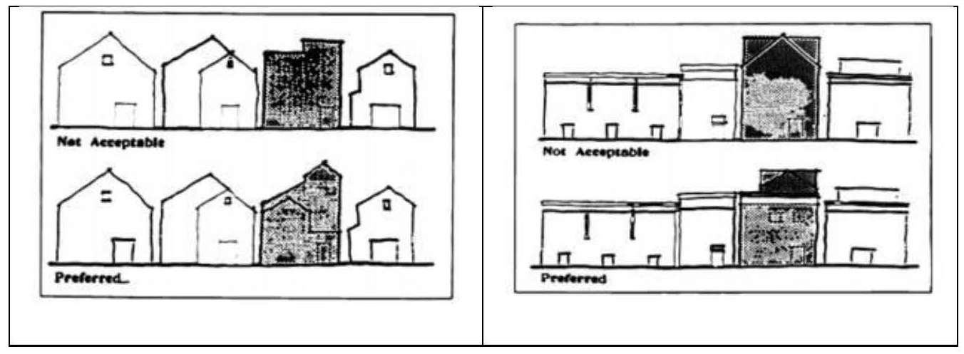
(a) Building Design – Massing. “Massing” is defined as a composition of two-dimensional shapes or three-dimensional volumes which gives the impression of weight, density and bulk. If the following are met acceptable massing may be accomplished:
(i) Design should result in buildings with a perceived size that maintains a human scale that is comfortable and attractive for pedestrians.
(ii) Design should result in a quality street environment that is attractive to pedestrians and development.
(iii) Buildings of special historic significance and merit should be preserved. Maintain or restore as many of the proportions, dimensions and architectural details of historical significance, which were original or added to the building during the designated historic period.
(iv) New or remodeled structures abutting or directly across from buildings that have been identified as historic should be designed so as to preserve, and not detract from, the historic context and merit of the building.
(v) Buildings should have consistent visual identity from all sides visible to the general public.
(b) Building Design – Articulation. “Articulation” is defined as the emphasis given to architectural elements (such as windows, balconies, entries, etc.) that create a complementary pattern or rhythm, dividing large buildings into smaller identifiable pieces. If the following are met acceptable articulation may be accomplished:
(i) The pattern and proportion of doors and windows should be similar to existing historic buildings in the WH district, and/or evoke the designated historic styles.
(ii) Finish materials, details and colors should evoke the designated historic styles.
(iii) Signage. Design for signs should emulate signage that existed during the designated historic period.
(4) Architectural Design Review Standards. The purpose of these architectural design review standards, along with the notebook “Historical Buildings of Empire and Front Street,” is to serve as a resource for designing development that will satisfy the architectural design review goals for the WH district. Design proposals may be approved if the following standards are met:
(a) Building Design – Massing.
(i) Use articulation on either new or existing building facades to reduce the bulk of buildings. Methods include, but are not limited to, the following:
(A) Modulation;
(B) Broken rooflines; or
(C) Building elements such as balconies, chimneys, porches or other entry details, and landscaping.
(ii) Use architectural features such as cornices or other details that lower the apparent height of the building.
(iii) Place display windows at the street level around the exterior of larger commercial buildings.
The pattern and proportion of windows, doors and other glazed areas is important in determining the building’s architectural character. Rooflines can reinforce the architectural character of a street. Architectural features like cornices can relate to adjacent buildings, lowering the apparent, conflicting height of the building.
(iv) The front elevation of large structures should be divided into smaller areas or planes. When the front elevation of a structure is more than 750 square feet in area, the front elevation should be divided into distinct areas by:
(A) Creating a bay window or other building extension of at least one foot or more from the main structure;
(B) Creating a roof pediment that is the full width of the structure; or
(C) Setting part of the facade back one or more feet from the rest of the facade.
(v) For existing buildings of historic significance (in the WH district, these buildings are the Marshfield Sun at 1049 North Front Street, the Coos Bay Iron Works at 896 North Front Street and the Cahill Building, formerly Ferguson Transfer, 318 North Front Street):
(A) Restore or retain as many historic features as possible;
(B) Maintain or restore original proportions, dimensions and architectural elements;
(C) Select paint and material colors which are historically accurate, coordinate the entire facade, and do not conflict with adjacent buildings; and
(D) Consult available historical resources such as the Coos Historical Society, private historians or photographic archives.
(vi) At locations abutting or adjacent to buildings of historical significance:
(A) Use a roofline that emulates the historic building;
(B) Use doors, windows, materials and details similar to the historic building; and
(C) Break up the building facade using articulation which reflects the scale and proportions of the historic building.
(vii) Continue exterior materials, architectural detailing, and color scheme around all sides of the building. Buildings must present an equivalent level of quality of materials, detailing and fenestration on all sides visible to the general public.
(viii) Reserve bright colors for trim or accents unless it is common to the architectural style.
(ix) Use of reflective exterior materials where glare would shine into nearby buildings is prohibited.
(b) Building Design – Articulation – Finish Materials.
(i) Buildings should use wood or simulated wood products as their exterior finish material on elevations exposed to view from locations accessible by the public. Horizontal wood or simulated wood siding and wood shingles should be applied with exposure of each course not exceeding eight inches in width. Vertical siding should be rough-sawn “board on board” typical to the designated historical styles.
(ii) Plain plywood or grooved plywood panels should not be used as exterior finish materials on elevations exposed to view from locations accessible by the public.
(iii) Concrete or concrete block should not be exposed to view as exterior finish materials except for foundation walls not extending more than one foot above the finished grade level adjacent to the wall.
(iv) Wavy corrugated metal siding (rather than bold rib, box rib or v-beam) may be used as the finish material on exterior walls only if combined with other materials and details in such a way as to create a design that reflects the designated historic styles.
(v) The design, detailing and trimming of the rooflines, porches, windows, doors and other architectural features should be in a manner that is in keeping with the designated historic styles.
(vi) Glass should be clear or ornamental stained glass. Translucent glazing should be used only for restrooms.
(vii) Roofing materials exposed to view should be wood shingles, composition roofing, or corrugated metal roofing in a subdued color that is in keeping with the historic styles noted.
(viii) Decorative features such as cupolas, cresting, chimneys, barge (rake), and soffit/fascia trim are encouraged if keeping with the architectural style.
(ix) Light fixtures should be integrated with architectural elements.
(A) Decorative light fixtures that are in keeping with the historic styles are encouraged.
(B) Exterior light fixtures must not compete with city-furnished sidewalk period lights. Building lights should be metal halide or incandescent and are to be directed away from pedestrians and street traffic so as to avoid glare.
(5) Signage. Signs will be reviewed by the design assistance team (DAT) based on the standards set forth below. A sign permit is also required which will be reviewed by staff pursuant to the provisions in Chapter 17.333 CBDC, Signs. If the provisions conflict, the stricter shall apply.
(a) Design for signs should emulate signage that existed during the designated historic period, and be consistent with the character of the storefront, the building on which they are situated and the area as a whole. Review for consistency includes, but is not limited to, evaluation of size, shape, position, materials and illumination in relationship to the facade and abutting and adjacent structures.
(b) Signs on a business front are limited to a building sign on each building face (identifying the building name), a sign for each business entry (vehicular or pedestrian), and interior painting of street-front windows.
(c) Signs shall have a minimum clearance of eight feet above a pedestrian walkway and 15 feet above a public street or alley, driveway, or parking lot. Signs shall not be closer than two feet to any curbline. A projecting sign shall not project more than eight feet beyond the property line.
(d) All signs shall:
(i) Be of an appropriate size and design;
(ii) Be sited sympathetically on the building;
(iii) Not obscure or remove detailing on the building;
(iv) Be designed as part of the building and not treated as an unrelated addition; and
(v) Be related to the style and character of the building and general area.
(e) Allowed Sign Types.
(i) “Wall/fascia sign” means a sign placed on the vertical surface of a wall or fascia where the wall or fascia is suitable for sign attachment. A wall/fascia sign must not extend across two storefronts or across separate buildings.
(ii) “Projecting or hanging sign” means a sign where the message area is displayed perpendicular to the building fascia.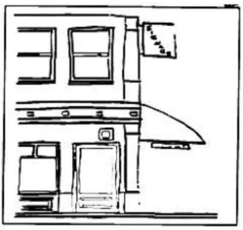
(iii) “Awning sign” means a structure made of fabric or similar material with a painted metal frame which is attached to a building and projects over a public walkway. An awning shall have no soffits, plastic components or internal lighting. Plastic awning fabrics are prohibited. Advertising material attached to an awning is an awning sign.
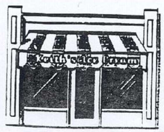
(iv) “Marquee sign” means either a fascia sign, projecting sign or awning sign which contains movable letters or devices. A marquee sign shall not contain any plastic parts and shall not be internally illuminated.
(v) Interior Painted Window Signs. These signs are regulated. However, interior painted window signs with holiday themes are allowed up to 45 days without approval of a sign permit.
(vi) Miscellaneous. Sign types not otherwise listed which comply with the requirements of this subsection may be allowed upon approval by the review authority upon recommendation of the DAT.
(vii) Neon Sign. Any sign where neon or other gas contained in tubing is illuminated by the application of electric current is prohibited, except property abutting North Bayshore Dr. (U.S. Highway 101) where signage would be allowed if placed within 10 feet of the west property line.
(viii) Sandwich Board. Portable signs that are not permanently affixed to the ground or a structure are prohibited.
(ix) Off-premises signs are prohibited.
(x) Readerboard signs are prohibited, except for properties abutting North Bayshore Dr. (U.S. Highway 101) and properties on North Front Street from Fir Ave. to Ivy Ave. if the readerboard sign is placed within 10 feet of the west property line. [Ord. 541 § 6 (Exh. 1), 2021; Ord. 532 § 2 (Att. B), 2020; Ord. 511 § 6 (Exh. 2), 2019; Ord. 503 § 1 (Exh. B), 2018; Ord. 473 § 3 (Exh. A), 2016].