


Chapter 17.330
OFF-STREET PARKING AND LOADING REQUIREMENTS
Sections:
17.330.010 Off-street parking requirements.
17.330.020 Joint use of facilities.
17.330.030 Parking design standards.
Prior legislation: Ord. 532.
17.330.005 Purpose.
(1) Ensure that adequate off-street parking is provided for new land uses and major alterations to existing uses, considering the demands likely to result from various uses, combinations of uses, and settings, and to avoid the negative impacts associated with spillover parking into adjacent neighborhoods and districts.
(2) Offer flexible means of minimizing the amount of area devoted to vehicle parking by allowing reductions in the number of required spaces in transit-served locations, shared parking facilities, and other situations expected to have lower vehicle parking demand.
(3) Ensure that parking and loading areas are designed to operate efficiently and effectively and in a manner compatible with on-site and surrounding land uses.
(4) Ensure that adequate off-street bicycle parking facilities are provided.
(5) Promote safe and attractive parking lot design.
(6) Accommodate and encourage increased use of alternative fuel and zero-emissions vehicles. [Ord. 590 § 1 (Att. B(R)), 2026; Ord. 541 § 6 (Exh. 1), 2021].
17.330.010 Off-street parking requirements.
(1) General Parking Requirements. Off-street parking shall be provided in compliance with Table 17.330.010(A).
(a) Where the number of required off-street parking spaces contains a fraction, that fraction shall be rounded up to the next whole parking space.
|
Use |
Minimum Number of Parking Spaces |
|---|---|
|
Residential: |
|
|
Dwelling, single-unit or duplex |
2 spaces per each single unit or 2 spaces for a duplex |
|
Dwelling, multi-unit |
1.5 spaces per dwelling unit |
|
Group residential care or treatment facility or senior citizen housing |
1 space per 3 beds |
|
Accessory dwelling unit |
Exempt |
|
Certified factory-built home, manufactured dwelling |
2 spaces per manufactured unit |
|
Certified factory-built home park model |
1 space per park model |
|
Commercial: |
|
|
Auto, boat, trailer/mobile home sales or service or nursery |
1 space per 500 square feet |
|
Retail stores |
1 space per 400 square feet of floor area |
|
Furniture or appliance sales and service |
1 space per 500 square feet |
|
Bank, medical or office buildings |
1 space per 250 square feet of floor area |
|
Personal service and repair |
1 space per 250 square feet of floor area |
|
Hotel, motel or bed and breakfast houses |
1 space per guestroom, plus 1 per every 25 rooms |
|
Hospital |
3 spaces per 2 beds |
|
Restaurants or drinking establishments |
1 space per 200 square feet of floor area |
|
Religious institutions |
1 space for each 6 seats or 12 feet of bench in the principal place of worship |
|
Skating rink or dance hall |
2 spaces per 100 square feet plus 1 per 2 employees |
|
Bowling alley |
2 spaces per lane |
|
Schools and Civic Uses: |
|
|
Preschool, elementary and middle school |
2 spaces per classroom and 1 space per additional office |
|
High school and further education |
6 spaces per classroom and 3 spaces per additional office |
|
Library, museums, art galleries |
1 space per 600 square feet of floor area |
|
Day care |
1 space per employee |
|
Industrial or manufacturing |
1 space per 500 square feet of floor area |
|
Commercial storage or warehousing |
1 space per 1,000 square feet of floor area |
|
Government buildings |
1 space per 330 square feet of floor area |
|
Place of assembly with seating |
1 space for each 4 seats or 8 feet of bench length which may potentially be provided in the main room of a church, religious institution, or other auditorium. Such space may not be provided in the required first 10 feet of any yard which abuts a street. |
|
Place of assembly without seating |
1 space per 4 persons, based on the occupancy load |
|
Uses not identified |
Requirement as determined by the director |
(2) All new developments, except for single-unit dwellings and duplexes, required to provide off-street vehicle parking shall provide bicycle parking consistent with the standards in Table 17.330.010(B).
|
Type of Use |
Number of Bicycle Parking Spaces |
|---|---|
|
Multi-unit residential |
One space per dwelling unit |
|
Commercial |
One space per use plus one space per 15 vehicle parking spaces |
|
Industrial, institutional and public uses |
Schools – One space per 25 students |
|
Transit stops – Two spaces |
|
|
Transit centers – Four spaces or one per 10 vehicle spaces, whichever is greater |
|
|
Other uses – One space per use plus one space per 10 vehicle parking spaces |
(3) Exempt Parking.
(a) WH District.
(i) WH-2 zone subdistrict. Except for tourist habitation – waterfront inn, off-street parking is not required.
(b) Downtown Parking District.
(i) There shall be no off-street parking requirements for any property included within the area identified in Figure 17.330.010(B), Downtown Parking District.
Figure 17.330.010(B) – Downtown Parking District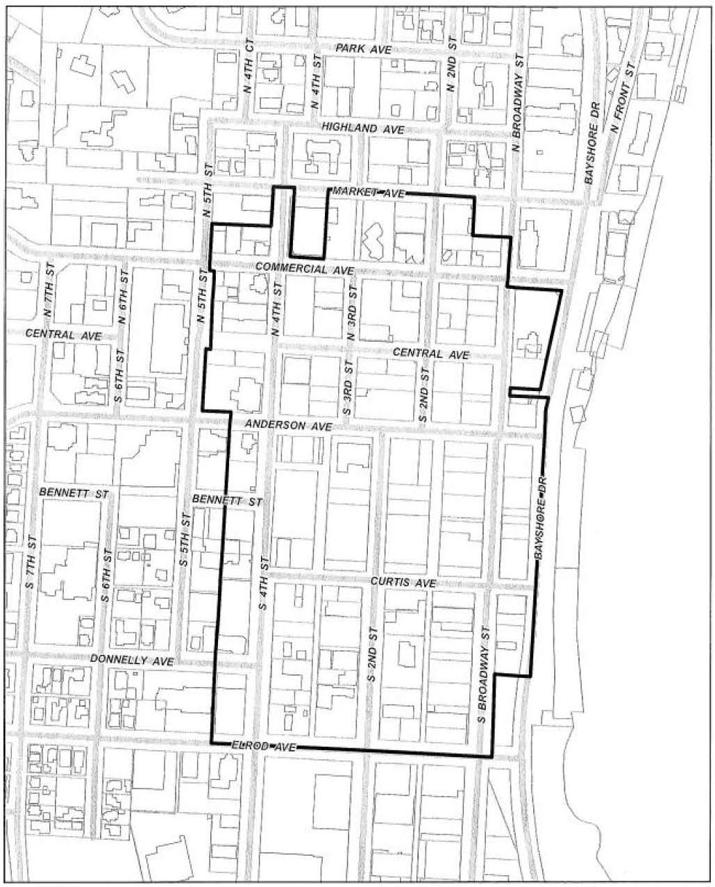
(c) Empire Parking District.
(i) Any use included in the area identified in Figure 17.330.010(C), Exempt Parking Area With Cap, must provide off-street parking for the number of spaces required in Table 17.330.010(A), Off-Street Parking Requirements, in excess of 25 spaces.
Figure 17.330.010(C) – Exempt Parking Area With Cap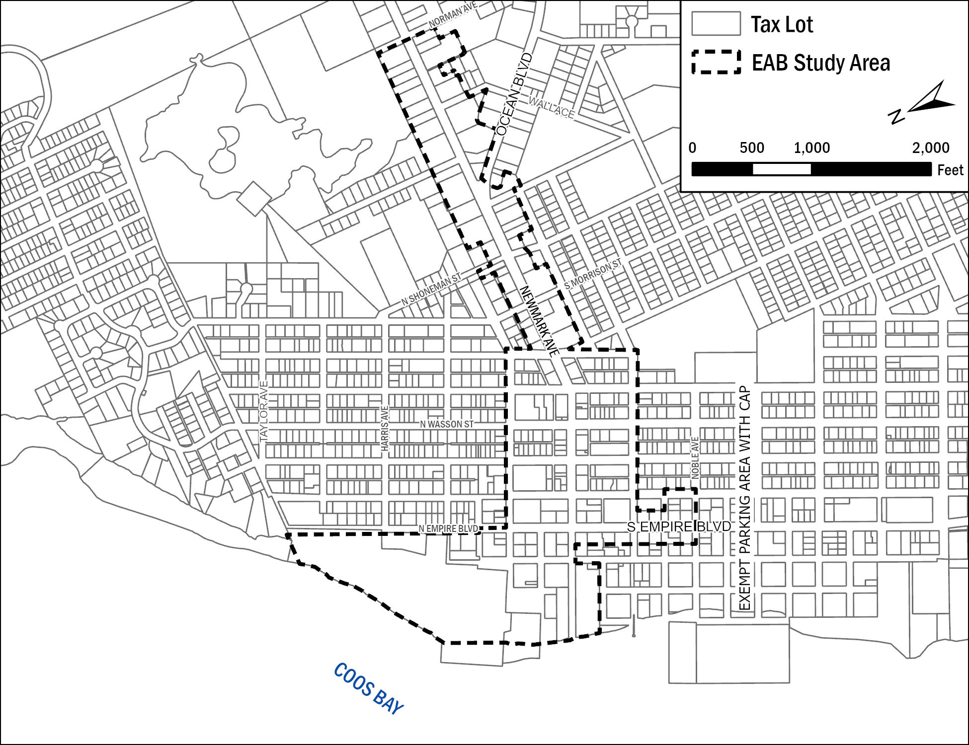
[Ord. 590 § 1 (Att. B(R)), 2026; Ord. 582 § 3, 2025; Ord. 541 § 6 (Exh. 1), 2021; Ord. 503 § 1 (Exh. B), 2018; Ord. 473 § 3 (Exh. A), 2016. Formerly 17.340.010].
17.330.020 Joint use of facilities.
(1) Joint parking and/or loading facilities serving two or more uses, structures, or parcels of land may be approved to satisfy the requirements of both facilities, provided the owners or operators of the uses, structures, or parcels show that their operations and parking needs do not overlap in point of time. If the uses, structures, or parcels are under separate ownership, the right to joint use of the parking space must be evidenced by a deed, lease, contract, or other appropriate written document to establish the joint use.
(2) Parking spaces and parking areas may be used for transit-related uses, such as transit stops and park-and-ride/rideshare areas, provided minimum parking space and design requirements for the site can still be met or the appropriate adjustment is granted. Transit stops and park-and-rides shall be consistent with the location and design specifications of the Coos County transit master plan. [Ord. 590 § 1 (Att. B(R)), 2026; Ord. 541 § 6 (Exh. 1), 2021; Ord. 526 § 5 (Exh. D), 2020; Ord. 503 § 1 (Exh. B), 2018; Ord. 473 § 3 (Exh. A), 2016. Formerly 17.340.020].
17.330.030 Parking design standards.
(1) Size of Parking Space. Each off-street parking space shall not be less than nine feet by 18 feet. Up to 40 percent of all required parking spaces can be designated for compact vehicles. Each compact parking space shall not be less than eight feet by 16 feet. Each compact parking space shall be identified as such and all off-street parking spaces shall be provided with adequate ingress and egress.
(a) Parking Stall Design and Minimum Dimensions. Where a new off-street parking area is proposed, or an existing off-street parking area is proposed for expansion, the entire parking area shall be improved in conformance with the CBMC.
(i) At a minimum the parking spaces and drive aisles shall be paved with asphalt, concrete, or other city-approved materials, provided the Americans with Disabilities Act requirements are met, and shall conform to the minimum dimensions in Table 17.330.030(A) and Figure 17.330.030.
(ii) All off-street parking areas shall contain wheel stops, perimeter curbing, bollards, or other edging as required to prevent vehicles from damaging buildings or encroaching into walkways, landscapes, or the public right-of-way.
|
Parking Angle < ° |
Curb Length |
Stall Depth |
Aisle Width |
Bay Width |
Stripe Length |
|||
|---|---|---|---|---|---|---|---|---|
|
Single D1 |
Double D2 |
One Way A1 |
Two Way A2 |
One Way B1 |
Two Way B2 |
|||
|
90° |
8' 6" |
18' |
36' |
23' |
23' |
59' |
59' |
18' |
|
60° |
10' |
20' |
40' |
17' |
18' |
57' |
58' |
23' |
|
45° |
12' |
18' 6" |
37' |
13' |
18' |
50' |
55' |
26' 6" |
|
30° |
17' |
16' 6" |
33' |
12' |
18' |
45' |
51' |
32' 8" |
|
0° |
22' |
8' 6" |
17' |
12' |
18' |
29' |
35' |
8' 6" |
Figure 17.330.030 – Parking Stall Design and Minimum Dimensions
(2) Location.
(a) Off-street parking facilities shall be located on site to the extent feasible.
(b) Off-site parking shall be no further than 300 feet from the site, measured from the nearest point of the parking facility to the nearest point of the nearest building that the facility is required to serve. Off-site parking shall be primarily employee parking.
(3) Materials, Design, and Lighting.
(a) Surfacing. Off-street parking facilities shall be surfaced with a durable and dustless surface (asphalt, concrete, or other city-approved material), shall be graded and drained so as to dispose of surface water to the satisfaction of the public works department and shall be maintained in good condition, free of weeds, dust, trash, and debris.
(i) Driveways. Driveways provide vehicular access to parking and dwelling units but do not provide primary pedestrian access to units. Driveways are intended to be used primarily for vehicular circulation where the following standards apply:
(A) Two-way driveways shall be a minimum width of 20 feet; one-way driveways shall be a minimum width of 12 feet.
(B) The maximum driveway width is 28 feet.
(C) Hammerheads or other such turnarounds may be required by the review authority for dead-end driveways. The dimensions of the hammerhead shall be adequate to meet the requirements of the public works and fire departments.
(ii) Existing Residential Improvements. Improvements to existing residential development, such as the addition of a carport or garage with driveway and maneuvering areas, shall require compliance with the surfacing requirements of this chapter if access to the improvement is gained from an improved street. At a minimum, the paved access must be 20 feet in length measured from the edge of the improved street on which access is gained.
(iii) Delays – Unimproved Rights-of-Way. Off-street parking and loading for residential and nonresidential uses on existing unpaved streets are allowed a delay from the surfacing requirements prior to the issuance of an occupancy permit. However, the property owner must consent and present a recorded deed restriction or covenant which states that remonstrance against any future street improvement project has been waived and that the required paving will be completed within 12 months after the street is improved.
(b) Circulation and Lighting. Parking clusters containing two or more parking spaces, except those accessory to a single-unit or duplex dwelling, must:
(i) Provide aisles or turnaround areas so that all vehicles may enter the street in a forward manner.
(ii) Serve a driveway designed and constructed to facilitate the flow of traffic on and off the site, with due regard to pedestrian and vehicle safety, and shall be clearly and permanently marked and defined.
(A) In no case shall two-way and one-way driveways be less than 20 feet and 12 feet, respectively, and arranged so as not to use any part of adjoining public sidewalks, street, or alley rights-of-way, except for ingress and egress.
(iii) Provide internal pedestrian connections in parking lots with more than 10 parking spaces located in commercial districts and in parking lots with more than 30 parking spaces located in noncommercial districts. These connections shall be a minimum of five feet wide and distinguished from vehicular areas through changes in elevation or contrasting paving materials (such as light-color concrete inlay between asphalt). Paint or thermo-plastic striping and similar types of nonpermanent applications may be approved for crossings of parking lot areas that do not exceed 24 feet in crossing length.
(iv) Provide at-grade pedestrian lighting level of no less than 0.2 foot-candles.
(v) Lighting used to illuminate off-street parking facilities shall be arranged so as to reflect light away from any adjoining residential area(s).
(4) Bicycle Parking. Bicycle parking spaces may be located within a garage, storage shed, basement, utility room, or similar area subject to the following standards:
(a) Bicycle parking shall be located in lighted, secure locations within 50 feet of the main entrance to a building, but not further from the entrance than the closest general-purpose automobile parking space.
(i) Where a building has multiple entrances, required bicycle parking shall be no farther than 50 feet from an entrance.
(ii) Bicycle parking shall be located and designed so as to not impede or create a hazard to pedestrians (a minimum 36-inch clear area shall be maintained between bicycles and other obstructions or buildings).
(b) The location and design of bicycle parking for transit stops and transit centers shall be determined through the development review process.
(5) Multi-Unit Developments. On-site parking shall be provided as part of any multi-unit development project in the form of garages (private or common), carports, and open parking areas.
(a) All parking, except private and common garages, shall be located in the rear of the property, with building construction occurring toward the front, closest to employment centers, shopping centers, and transit corridors to minimize walking distance, and designed as follows:
(i) All new townhouse developments shall include four additional off-street parking spaces for every three units. These spaces are to be evenly dispersed throughout the development with no more than four spaces being located in any one specific area. The director is authorized to establish final location of these parking spaces.
(ii) Parking Clusters.
(A) Maximum Size of Parking Clusters. Individual parking clusters shall contain no more than 50 contiguous spaces and shall be no more than 9,000 square feet in size. No more than three individual parking clusters may be connected by an aisle or driveway.
(B) Parking Cluster Separation. Landscape areas shall be placed between parking clusters to visually interrupt rows of parked vehicles and to separate individual parking clusters.
(C) Pedestrian Access. Parking clusters shall be designed to accommodate pedestrian and bicycle access in accordance with CBDC 17.335.090.
(6) Manufactured Home and RV and Park Model Parks.
(a) Off-street parking shall be provided:
(i) For manufactured home parks, two off-street parking spaces per dwelling unit, each with a dimension of 10 feet by 20 feet, shall be located on the lot or property which they are intended to serve. Off-street parking shall be provided within a garage or carport.
(ii) For RV and park model parks, one 10-foot-by-20-foot off-street parking space per unit located on the lot or property which they are intended to serve.
(b) Visitor Parking. At least one off-street parking space shall be provided for every two manufactured home lots or sites for use by visitors and delivery vehicles. These spaces shall be signed or designated as such. These spaces shall be within 100 feet of the lots to be served. Visitor parking may be provided on streets designed to accommodate parking and two standard lanes of traffic.
(c) All on-site parking shall be designed and constructed in compliance with the parking facility standards of this chapter.
(d) Trucks with a maximum gross vehicle weight more than one and one-half tons, recreational vehicles, boats on boat trailers, and similar equipment shall be parked in one of the two allocated off-street parking spaces if stored on an individual lot or space; provided no more than one passenger vehicle may be parked on a given lot or space. Car-top boats and canoes are exempt from this requirement.
(7) Limitations.
(a) Parking Frontage. To strengthen the presence of buildings on the street, parking and vehicle use areas and garages adjacent to any public or private street frontage shall extend across no more than 50 percent of any street frontage.
(i) No parking spaces shall be placed within any required front yard area with exception for the following:
(A) Underground parking facilities.
(B) Single-unit and duplex dwelling parking areas.
(b) Access.
(i) Access to and from off-street parking areas onto arterial streets shall not permit backing onto the arterial street.
(ii) Lots with alley access, either at the rear yard or along the side yard, shall use the alley to provide access to the development site if either:
(A) The alley right-of-way width is 20 feet for the length of the alley between the lot and the street; or
(B) The lot’s only street frontage is on an arterial or collector street.
(c) Bumper Guards and Wheel Stops. Permanent bumper guards or wheel stops shall be provided for parking spaces located adjacent to walls, fences, buildings, landscaping, etc., to prevent damage to any such objects or landscaped areas. However, if a landscaping curb is used in lieu of a wheel stop, it must be of sufficient width so as not to damage landscaping for a minimum of 12 inches, and must not encroach into the required space area more than 24 inches at front of parking space.
(d) Employee Parking. Parking areas that have designated employee parking and more than 20 automobile parking spaces shall provide at least 10 percent of the employee parking spaces (minimum two spaces) as preferential carpool and vanpool parking spaces. Preferential carpool and vanpool parking spaces shall be closer to the employee entrance of the building than other parking spaces, with the exception of ADA-accessible parking spaces.
(e) Parking lots and outdoor storage of vehicles or recreational vehicles shall not be a primary use for any property located in a residential zone district.
(8) Criteria for Adjustment. Adjustments to the standards in this section may be made, based on the criteria in Chapter 17.372 CBDC, Adjustment Review. [Ord. 590 § 1 (Att. B(R)), 2026; Ord. 541 § 6 (Exh. 1), 2021; Ord. 526 § 5 (Exh. D), 2020; Ord. 503 § 1 (Exh. B), 2018; Ord. 473 § 3 (Exh. A), 2016. Formerly 17.340.030].
17.330.040 Loading.
Every use for which a building is erected or structurally altered which will require the receipt or distribution of materials or merchandise by truck or similar vehicle shall provide off-street loading space on the basis of minimum requirements as follows:
(1) Commercial, industrial, and public uses shall provide truck loading or unloading berths in accordance with Table 17.330.040(A):
|
Square Feet of Floor Area |
Number of Berths Required |
|---|---|
|
Less than 5,000 |
0 |
|
5,000 – 30,000 |
1 |
|
30,000 – 100,000 |
2 |
|
100,000 and over |
3 |
(2) Restaurants, office buildings, hotels, motels, hospitals and institutions, schools and colleges, public buildings, recreation or entertainment facilities, and any similar uses shall provide off-street truck loading or unloading berths in accordance with Table 17.330.040(B):
|
Square Feet of Floor Area |
Number of Berths Required |
|---|---|
|
Less than 30,000 |
0 |
|
30,000 – 100,000 |
1 |
|
100,000 and over |
2 |
(3) A loading berth shall contain space 12 feet wide, 35 feet long, and have a height clearance of 14 feet. Where the vehicles generally used for loading and unloading exceed these dimensions, the required length of these berths shall be increased.
(4) Existing loading space shall not be eliminated, if elimination would result in less space than is required to adequately handle the needs of the particular use.
(5) Off-street parking areas used to fulfill the requirement of this title shall not be used for loading and unloading operations except during periods of the day when not required to take care of parking needs.
(6) Loading docks shall be located on the side or rear of the building. [Ord. 590 § 1 (Att. B(R)), 2026; Ord. 541 § 6 (Exh. 1), 2021; Ord. 503 § 1 (Exh. B), 2018; Ord. 473 § 3 (Exh. A), 2016. Formerly 17.340.040].