


Chapter 16.12
SHORELINE MASTER PROGRAM
Sections:
16.12.020 Shoreline designation regulations.
16.12.030 General (island-wide) regulations.
16.12.040 Specific shoreline use and development regulations.
16.12.050 Shoreline modification regulations.
16.12.070 Violations, enforcement, and penalties.
16.12.010 Introduction.
A. Purpose and Intent. The shoreline master program is intended to implement the Shoreline Management Act of 1971 (Chapter 90.58 RCW) by:
1. Planning for and guiding the orderly development of the shoreline in a positive, effective, and equitable manner, protecting and restoring shoreline resources, and helping to assure public access to the shoreline;
2. Promoting the health, safety, and general welfare of the community by providing long-range, comprehensive policies and effective, reasonable regulations for use and development of Bainbridge Island’s shorelines;
3. Ensuring, at minimum, no net loss of shoreline ecological functions and ecosystem-wide processes;
4. Planning for the restoration of shorelines that have been impaired or degraded in the past and in a manner that educates the community in the use and protection of its shorelines;
5. Adhering to and fostering the policies of the Act contained in RCW 90.58.020 for shorelines of the state; and
6. Improving the water quality of the Puget Sound.
B. Scope of Shoreline Management Act. The Act covers all shorelines of the state, including “shorelines” and “shorelines of statewide significance.” Figure 16.12.010-1 illustrates shoreline jurisdiction on coastal shorelines.
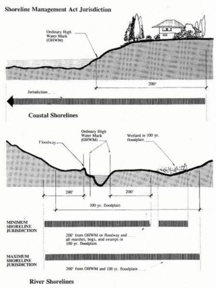
Figure 16.12.010-1 Shoreline Jurisdiction
Provisions of the Act apply to the following geographical shoreline areas:
1. All marine waters of the state, together with the lands underlying them;
2. Segments of streams and rivers where the mean annual flow is more than 20 cubic feet per second (cfs);
3. Lakes and reservoirs 20 acres and greater in area;
4. Shorelands extending landward for 200 feet in all directions as measured on a horizontal plane from the ordinary high water mark; floodways and contiguous floodplain areas landward 200 feet from such floodways; and all wetlands and river deltas associated with the streams, lakes, and tidal waters; and
5. Shorelines of statewide significance as defined in RCW 90.58.030 or its successor. This includes those areas of Puget Sound lying seaward from the line of extreme low tide.
C. Relationship to Other Plans and Regulations. The shoreline master program regulations are used as an overlay to other city policies and regulations for properties within shoreline jurisdiction. The following provisions apply to this program in relationship to other plans and regulations:
1. In addition to compliance with the provisions of the Shoreline Management Act of 1971 (also called “the Act”; Chapter 90.58 RCW) and the State Master Program Approval/Amendment Procedures and Master Program Shoreline Guidelines (the “Guidelines” or “Shoreline Master Program Guidelines”; Chapter 173-26 WAC), this shoreline master program must be consistent with local plans and policy documents, specifically, the city’s comprehensive plan and the city’s critical areas regulations. This shoreline master program must be consistent with the regulations developed by the city to implement its plans, such as the zoning code and subdivision code, as well as regulations relating to building construction and safety.
2. Uses and developments regulated by this program may also be subject to other provisions of the Bainbridge Island Municipal Code, the city of Bainbridge Island comprehensive plan, the Washington State Environmental Policy Act (Chapter 43.21C RCW and Chapter 197-11 WAC), Chapter 173-27 WAC, Shoreline Management Permit and Enforcement Procedures, and other local, state and federal laws.
3. Project proponents are responsible for complying with all applicable laws prior to commencing any use, development or activity.
4. Where this program makes reference to any RCW, WAC, or other state or federal law or regulation, the most recent amendment or current edition shall apply.
5. In the event of a conflict between the provisions of this program and the laws, regulations, codes or rules of any other authority having jurisdiction within the city, the regulations that provide more protection to the shoreline area shall apply, except when constrained by federal or state law, or where specifically provided otherwise in this program.
6. Other activities that could occur along the shoreline (starting bonfires, disposing or spilling/releasing of regulated or hazardous waste products, use of pesticides, activities within wetlands) may require other permits, review, or approval not identified here.
D. Applicability of Bainbridge Island Shoreline Master Program.
1. The Bainbridge Island shoreline master program applies to 200 feet landward of ordinary high water mark and all marine waters out to the midline of Puget Sound, Port Madison, Agate Pass, Port Orchard and Rich Passage. The SMP does not apply to freshwater lakes or streams on Bainbridge Island.
2. The provisions of this program apply to both existing and new development, uses, lots, and activities as follows:
a. Development, uses, lots, and activities lawfully occurring, established or constructed prior to the effective date of the initial adoption of this program (November 26, 1996), or amendments thereto, are not required to meet this program’s requirements, unless new development or changes to a development, use, lot or structure that would require review under this program are proposed.
b. All existing legally constructed single-family residences and accessory structures, including lawns, landscaping and recreation areas, which do not meet the standards of this program are allowed to continue, and are allowed to be maintained, repaired, remodeled, or replaced.
c. All proposed uses and development occurring within shoreline jurisdiction must be consistent with Chapter 90.58 RCW, the Shoreline Management Act and this program.
d. Uses and activities that do not meet the definition of “development” may be subject to the provisions and regulations of this program.
3. Any person wishing to undertake activities constituting “development” within shoreline jurisdiction shall apply to the administrator for a shoreline permit. Based on the provisions of this master program, the administrator shall determine if a letter of exemption, a substantial development permit, a shoreline conditional use permit, and/or a shoreline variance is required. Substantial development shall not be undertaken within the jurisdiction of the Act and this master program unless a substantial development permit has been obtained and the appeal period has been completed and any appeals have been resolved and/or the project proponent is allowed to proceed under the provisions of the Act or by court order. “Substantial development” shall be defined as it is by the Act (RCW 90.58.030) and supplementing provisions of the Washington Administrative Code (WAC 173-27-040).
4. Developments exempt from a substantial development permit, which are outlined in BIMC 2.16.165, shall require a letter of exemption. A project that qualifies as “exempt development” may also require a shoreline conditional use permit, and/or a shoreline variance.
5. This master program shall apply to every individual, firm, partnership, association, organization, corporation, local or state governmental agency, public or municipal corporation, or other entity which develops, owns, leases or administers lands, wetlands, or waters that fall under the jurisdiction of the Act.
6. Applicability of this master program to federal lands and agencies shall be consistent with WAC 173-27-060. (Ord. 2020-17 § 3 (Exh. A), 2020; Ord. 2014-04 § 3 (Exh. 1 § 1), 2014)
16.12.020 Shoreline designation regulations.
A. Shoreline Designation Map.
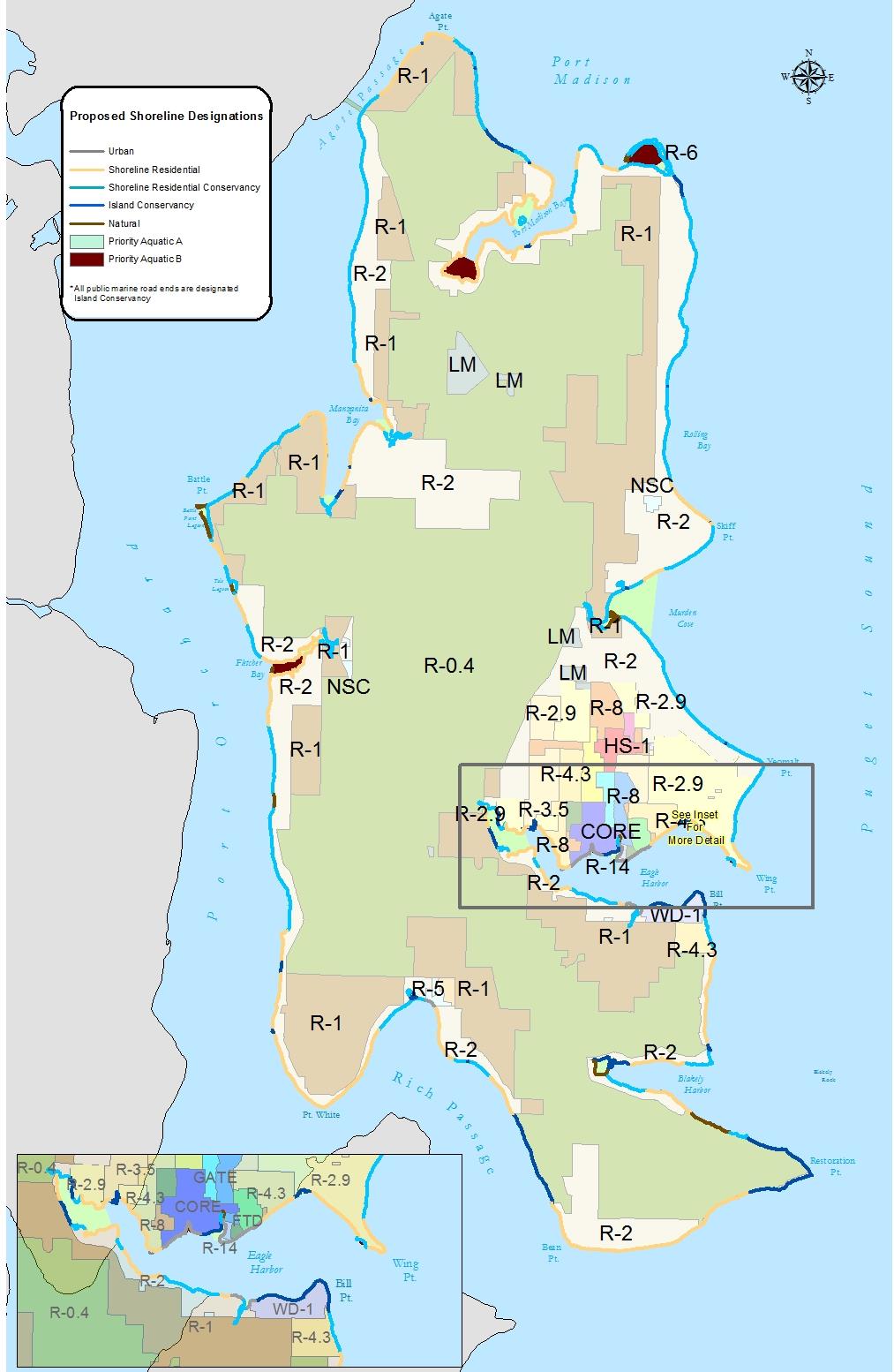
B. Upland Designations.
1. Urban. The purpose of the urban designation is to provide for high-intensity water-oriented commercial, transportation, industrial, mixed use, multifamily residential, public access and recreational uses while protecting existing natural resources, ecological functions and ecosystem-wide processes, and restoring ecological functions in areas that have been previously degraded.
2. Shoreline Residential. The purpose of the shoreline residential designation is to provide for residential development and appurtenant structures, appropriate public access and recreational use, which are consistent with the Shoreline Management Act, while protecting existing natural resources, ecological functions and ecosystem-wide processes, and restoring ecological functions in previously degraded areas.
3. Shoreline Residential Conservancy. The purpose of the shoreline residential conservancy designation is to accommodate compatible residential uses while protecting, conserving, and restoring shoreline ecological functions and processes of open space, floodplains or other flood prone areas, and other sensitive lands. It is the further purpose to conserve and manage valuable historic and cultural resources where they exist. Due to the more sensitive characteristics of these areas, a higher level of development standards is warranted.
4. Island Conservancy. The purpose of the island conservancy designation is to accommodate a variety of private or public recreational uses that might have a higher level of impact than would be allowed in the natural designation. Uses should incorporate elements compatible with protecting, conserving and restoring ecological functions and ecosystem-wide processes of open space, floodplains or other flood prone areas, and other sensitive lands, and manage valuable historic and cultural resources where they exist.
5. Natural. The purpose of the natural designation is to protect those shoreline areas where the majority of natural ecological functions and/or shoreline ecosystem-wide processes are retained, often evidenced by the shoreline configuration and the presence of native vegetation. Generally, but not necessarily, they include ecologically intact shorelines that are free of structural shoreline modifications, structures, and intensive human uses or have potential for restoration.
C. Aquatic Designations.
1. Aquatic. The purpose of the aquatic designation is to protect, restore and manage the sensitive and unique characteristics and resources of the waters of the Puget Sound, tidelands, and submerged intertidal areas located waterward of the ordinary high water mark. The aquatic designation may allow either multiple water-dependent uses or specific dominant water-dependent uses. It is intended to promote sustainable use of the natural features and resources of aquatic areas.
2. Priority Aquatic. The purpose of the priority aquatic designation is to protect, preserve, restore and manage aquatic areas of sensitive and unique ecological value that include those portions of the marine waters of the city that exist in a relatively natural state, free of human influence, or which contain resources, biological diversity, or other features that are particularly sensitive to human activity, or which contain unique, historical, archaeological, cultural, or educational features that merit special protection. (Ord. 2020-17 § 3 (Exh. A), 2020; Ord. 2014-04 § 3 (Exh. 1 § 3), 2014)
16.12.030 General (island-wide) regulations.
A. Regulations – General.
1. All new shoreline uses and shoreline modification activities, including those that do not require a shoreline substantial development permit, must conform to all applicable goals, policies, shoreline designations (including the shoreline designation map), and regulations and use tables provided in this master program.
2. Shoreline modification activities must be in support of an allowable shoreline use which conforms to the provisions of the master program. Except as otherwise noted, all shoreline modification activities not associated with a legally existing or approved shoreline use are prohibited.
3. Shoreline uses, modification activities, and conditions listed as prohibited in Table 16.12.030-1 shall not be eligible for consideration as a shoreline variance or shoreline conditional use permit.
4. Uses, modification activities, and conditions that are not prohibited and not listed in Table 16.12.030-1 shall be reviewed through the shoreline conditional use process.
5. The policies listed in the master program shall provide broad guidance and direction and shall be used by the director in interpreting the regulations.
6. BIMC Title 18, Zoning, or its successor also apply to shoreline parcels.
7. Where provisions of this master program or other provisions in BIMC conflict, the conflict shall be resolved by the director of planning and community development by applying the provision that provides the most protection of shoreline ecological functions consistent with the purposes and intent of the Shoreline Management Act. If the director’s decision is made in response to a code interpretation request filed under BIMC 2.16.020.D, the decision shall be appealable in the same manner as other code interpretations. If the director’s decision is made in the processing of a development permit, the director’s decision shall be appealable as part of the permit decision.
8. The use table (Table 16.12.030-1), shoreline setback table (Table 16.12.030-2), and the shoreline buffer table (Table 16.12.030-3) provide regulatory use and dimensional provisions for each shoreline designation.
9. An increase in the dimensional height standard (Table 16.12.030-2) for essential public facilities shall be reviewed through a shoreline conditional use. Submittal requirements are in the administrative manual.
10. Submittal requirements for all shoreline development permits or shoreline exemptions are in BIMC Title 2 and the administrative manual.
EXPLANATION OF TABLE ABBREVIATIONS
The abbreviations used in the Permitted Use Table have the following meanings:
ο “P” in a cell indicates that the use is permitted by right in that designation. Permitted uses are subject to all other applicable regulations of this program, including the use-specific standards.
ο “C” in a cell indicates that, in the respective designation, the use is a conditional use that is allowed only if reviewed and approved in accordance with the procedures set forth in BIMC Title 2. Unless otherwise stated in this program or in a conditional use approval, conditional uses are subject to all other applicable regulations of this code, including the use-specific standards.
ο An “A” in a cell indicates that the use is permitted as an accessory use to a permitted use or to an approved conditional use in the same designation. In the case of approved conditional uses, accessory uses listed in the table are permitted unless the terms of the conditional use permit prohibit that accessory use.
ο A “CA” in a cell indicates that the use is permitted as an accessory use to a permitted use or to an approved conditional use, but that a conditional use permit is always required.
ο An “X” indicates that the use is prohibited in the respective designation. The use may be allowed outside the shoreline jurisdiction. See BIMC Title 18, Zoning.
ο The column headed “Use Specific Standards” identifies a subsection within this chapter that imposes additional standards with which the use must comply. The use specific standard may limit the “P” or “C” designation to certain areas.
|
“P” = Permitted Use |
“X” = Prohibited Use |
“A” = Accessory Use |
|||||||
|---|---|---|---|---|---|---|---|---|---|
|
“C” = Conditional Use |
“#” = Same as Upland Property |
“CA” – Conditional Accessory Use |
|||||||
|
SHORELINE USE |
UPLAND DESIGNATION |
AQUATIC DESIGNATION |
Use Specific Standards |
||||||
|
Natural |
Island Conservancy |
Shoreline Residential Conservancy |
Shoreline Residential |
Urban |
Aquatic |
Priority Aquatic |
|||
|
A |
B |
||||||||
|
Natural Resource Management |
|||||||||
|
Agriculture |
X |
X |
X |
X |
X |
X |
X |
X |
|
|
Aquaculture |
C[1] |
X |
C |
C |
C |
C |
C[1] |
C[1] |
|
|
Aquaculture, Shellfish Garden |
X |
P |
P |
P |
P |
P |
P[1] |
P[1] |
|
|
Flood Hazard Management [7] |
X |
C |
C |
C |
C |
# |
X |
X |
|
|
Stormwater Management [7] |
X |
P |
P |
P |
P |
# |
X |
X |
|
|
Forest Practices |
X |
X |
C |
C |
C |
X |
X |
X |
|
|
Shoreline Restoration |
P |
P |
P |
P |
P |
P |
P |
P |
|
|
Commercial Development |
|||||||||
|
Boating Facilities |
X |
C[8] |
X |
C[9] |
P |
# |
X |
X |
|
|
Non-Water-Oriented |
X |
X[8] |
X[22] |
X |
C[17] |
X |
X |
X |
|
|
Water-Dependent |
X |
X |
X[22] |
C |
P |
# |
X |
X |
|
|
Water-Related or Enjoyment |
X |
X |
X[22] |
C |
P |
X |
X |
X |
|
|
Educational and Community Facilities |
|||||||||
|
Educational Facility |
X |
C |
C |
C |
P |
X |
X |
X |
|
|
Governmental Facility |
X |
X |
C |
C |
P |
X |
X |
X |
|
|
Religious Facility |
X |
C |
C |
C |
P |
X |
X |
X |
|
|
Cultural and Entertainment Facilities |
|||||||||
|
Club |
X |
C |
C |
C |
P |
X |
X |
X |
|
|
Commercial Amusement |
X |
X |
C |
C |
P |
X |
X |
X |
|
|
Cultural Facility |
X |
C |
C |
C |
P |
X |
X |
X |
|
|
Entertainment Facility |
X |
X |
C |
C |
P |
X |
X |
X |
|
|
Industrial |
|||||||||
|
Mining |
X |
X |
X |
X |
X |
X |
X |
X |
|
|
Non-Water-Oriented |
X |
X |
X |
X |
X |
X |
X |
X |
|
|
Solid Waste Disposal |
X |
X |
X |
X |
X |
X |
X |
X |
|
|
Water-Dependent |
X |
X |
X |
X |
P |
# |
X |
X |
|
|
Water-Related |
X |
X |
X |
X |
C |
# |
X |
X |
|
|
Water Enjoyment |
X |
X |
X |
X |
X |
X |
X |
X |
|
|
Overwater Structures |
|||||||||
|
Boatlift |
X |
X |
P |
P |
P |
# |
X |
# |
|
|
Marine Railway |
X |
X |
P |
P |
P |
# |
X |
X |
|
|
Marine Railway, Retractable [12] |
X |
P |
P |
P |
P |
# |
X |
# |
|
|
Mooring Buoys |
X |
P |
P |
P |
P |
# |
X |
X |
|
|
Piers and Docks |
X |
C[16] |
P |
P |
P |
# |
X |
P |
|
|
Recreational Floats |
X |
X |
X |
P |
P |
# |
X |
X |
|
|
Recreational Development |
|||||||||
|
Golf Courses |
X |
C |
X |
C |
C |
X |
X |
X |
|
|
Non-Water-Oriented |
X |
X |
X |
C |
C |
X |
X |
X |
|
|
Recreation, Active |
X |
C[16] |
C[19] |
C |
P |
# |
X |
X |
|
|
Recreation, Passive |
P |
P |
P |
P |
P |
# |
P[14] |
P[14] |
|
|
Event: Recreation, Culture, Education |
|||||||||
|
Water-Oriented |
X |
P |
P |
P |
P |
# |
X |
X |
|
|
Residential |
|||||||||
|
Accessory Dwelling Unit |
X |
C |
C[19] |
C |
C |
X |
X |
X |
|
|
Subdivision |
C |
P |
P |
P |
P |
# |
# |
# |
|
|
Multifamily [22] |
X |
X |
X |
P |
P |
X |
X |
X |
|
|
Single-Family |
X |
C |
P |
P |
P |
X |
X |
X |
|
|
Shoreline/Aquatic Modification [5] [7] |
|||||||||
|
Beach Nourishment (Mitigation) |
C |
P |
P |
P |
P |
# |
# |
# |
|
|
Beach Enhancement (Nonrestoration) [6] |
C[12] |
C[12] |
C[12] |
C[12] |
C[12] |
# |
# |
# |
|
|
Breakwaters |
X |
X |
X |
X |
X |
X |
X |
X |
|
|
Dredging |
X |
X |
X |
X |
X |
C |
X |
C |
|
|
Drift Sill |
X |
X |
X |
X |
X |
P |
P |
P |
|
|
Landfill |
C |
C |
C |
C |
C |
# |
X |
X |
|
|
Fill |
X |
C |
X |
X |
C |
# |
X |
X |
|
|
Repair of Shoreline Stabilization |
X |
P |
P |
P |
P |
# |
# |
# |
|
|
New or Replacement Shoreline Stabilization, Hard [4] |
|||||||||
|
New Bulkheads |
X |
X |
P[19] |
P |
P |
# |
X |
X |
|
|
Replacement Bulkheads |
X |
X |
P[19] |
P |
P |
# |
# |
# |
|
|
Gabions |
X |
X |
X |
X |
X |
X |
X |
X |
|
|
Weirs, Groins (Rock or Concrete) |
X |
X |
X |
X |
X |
X |
X |
X |
|
|
Jetties |
X |
X |
X |
X |
X |
X |
X |
X |
|
|
Levees/Dikes |
X |
X |
X |
X |
X |
X |
X |
X |
|
|
Retaining Walls and Bluff Walls |
X |
C |
C |
C |
C |
X |
X |
X |
|
|
Revetments |
X |
X |
X[2] |
X[2] |
X[2] |
# |
X |
X |
|
|
Seawalls |
X |
X |
X |
X |
X |
X |
X |
X |
|
|
Hybrid |
X |
P |
P |
P |
P |
# |
# |
# |
|
|
New or Replacement Shoreline Stabilization Non-Structural and Soft |
|||||||||
|
Nonstructural Stabilization, Soft-Treatment |
X |
P |
P |
P |
P |
# |
# |
# |
|
|
Transportation |
|||||||||
|
Existing Road Repair |
X |
P |
P |
P |
P |
X |
X |
X |
|
|
New Arterials |
X |
X |
X |
X |
X |
X |
X |
X |
|
|
New Highways |
X |
X |
X |
X |
X |
X |
X |
X |
|
|
New Secondary Arterials |
X |
X |
X |
X |
X |
X |
X |
X |
|
|
Float Plane Facilities and Services |
X |
X |
X |
X |
C |
# |
X |
X |
|
|
Heliports |
X |
X |
X |
X |
X |
X |
X |
X |
|
|
Additional Bridge to Bainbridge Island |
X |
X |
X |
X |
X |
X |
X |
X |
|
|
Parking (Primary) |
X |
X |
X |
X |
X |
X |
X |
X |
|
|
Public Access Facilities |
|||||||||
|
Public Ferry Terminal Facilities and Services |
X |
X |
X |
X |
P |
# |
X |
X |
|
|
Overwater Public Ferry Terminal Facilities and Services |
X |
X |
X |
X |
C[10] |
# |
X |
X |
|
|
Railroads |
X |
X |
X |
X |
X |
X |
X |
X |
|
|
Trails |
P |
P |
P |
P |
P |
# |
# |
# |
|
|
Utilities & Telecommunication |
|||||||||
|
Utilities (Primary) |
X |
X |
C[11] |
C[11] |
C[11] |
# |
X |
X |
|
|
Signs |
|||||||||
|
Primary |
X |
X |
X |
X |
X |
P |
X |
X |
|
|
Accessory Structures |
|||||||||
|
All Uses |
|||||||||
|
Potable Water Wells |
X |
A |
A |
A |
A |
X |
X |
X |
|
|
Signs |
X[20] |
X[20] |
P |
P |
P |
P |
X[20] |
X[20] |
|
|
Tram |
X |
A |
A |
A |
A |
# |
X |
X |
|
|
Underground Utilities |
X |
A[21] |
A[21] |
A[21] |
A[21] |
# |
X |
X |
|
|
Residential |
|||||||||
|
Upland Appurtenant Structures |
X |
CA |
A |
A |
A |
# |
X |
X |
|
|
Commercial |
|||||||||
|
Upland Appurtenant Structures That Support a Water-Dependent Use [13] |
X |
X |
X |
CA |
A |
# |
X |
X |
|
|
Upland Appurtenant Structures That Support a Water-Related or Water Enjoyment Use [13] |
X |
X |
X |
CA |
A |
X |
X |
X |
|
|
Upland Appurtenant Structures That Support a Non-Water-Oriented Use [13] |
X |
X[8] |
X |
X |
C[17] |
X |
X |
X |
|
|
Industrial |
|||||||||
|
Upland Appurtenant Structures That Support a Water-Dependent Use [13] |
X |
X |
X |
X |
A |
# |
X |
X |
|
|
Upland Appurtenant Structures That Support a Water-Related Use [13] |
X |
X |
X |
X |
CA |
# |
X |
X |
|
|
Upland Appurtenant Structures That Support a Water Enjoyment Use [13] |
X |
X |
X |
X |
X |
X |
X |
X |
|
|
Upland Appurtenant Structures That Support a Non-Water-Oriented Use [13] |
X |
X |
X |
X |
X |
X |
X |
X |
|
|
Public Park/Recreational Development |
|||||||||
|
Public Pathways to the Shoreline |
A |
A |
A |
A |
A |
# |
# |
# |
|
|
Public Stairway |
A |
A |
A |
A |
A |
# |
# |
# |
|
|
Access Roads |
X |
A |
A |
A |
A |
X |
X |
X |
|
|
Upland Appurtenant Structures That Support a Water-Oriented Active Recreational Use |
X |
A |
CA |
CA |
A |
# |
X |
X |
|
|
Upland Appurtenant Structures That Support a Water-Oriented Passive Recreational Use |
A |
A |
A |
A |
A |
# |
A[14] |
A[14] |
|
|
Upland Appurtenant Structures That Support a Non-Water-Oriented Use |
X |
X |
X |
X |
X |
X |
X |
X |
|
|
[1] Allowed if using native species and part of an approved shoreline restoration project. [2] Revetments are prohibited unless they are constructed as part of a public facilities project. [3] Construction of a bulkhead, revetment, or other structure for the purpose of retaining a landfill or creating dry land is prohibited, unless it is proposed in conjunction with a water-dependent or public use. [4] Stabilization that would cause significant impacts to adjacent or down current properties is prohibited. [5] Shoreline modification should not be located on feeder bluffs, except when the area is already developed with a single-family primary structure, in which case stabilization may be allowed pursuant to the provisions in BIMC 16.12.050.B, Shoreline Stabilization. [6] Beach enhancement is prohibited if it interferes with the normal public use of the navigable waters of the state. [7] Shoreline stabilization and flood protection works are prohibited in wetlands (located in both the upland and the shoreline jurisdiction). They are also prohibited in salmon and trout spawning areas, except for fish or wildlife habitat enhancement. [8] Public parks only. Non-water-oriented commercial development only for concessions as accessory use allowed as an SSDP. [9] Community and joint-use docks providing moorage for six or more vessels are permitted with an SSDP but must comply with the provisions in BIMC 16.12.040.C, Boating Facilities, as well as the provisions in BIMC 16.12.050.C, Overwater Structures. [10] New overwater facilities are permitted as a conditional use only in the ferry terminal district. Normal repair and maintenance of existing overwater facilities do not require a shoreline conditional use permit, but may require an SSDP. [11] Permitted as a conditional use if no feasible alternative exists. [12] If upland of priority aquatic designation, then the use is prohibited. [13] All structures are prohibited in Zone 1 upland of a priority aquatic Category A designation. [14] Passive recreational uses and activities are allowed. Development and associated structures is allowed through a shoreline conditional use permit. [15] As allowed by island conservancy designation. [16] Except in Waterfront Park, a dock is permitted with a SSDP. [17] Mixed-use commercial/industrial only. [18] Day use only. [19] Prohibited or restricted in the Point Monroe District. [20] Allowed for public park, interpretive, information, direction or dedication. Temporary signs are allowed in accordance with subsection C.5 of this section, Signs. [21] Conditional use when primary use is a conditional use. [22] Mixed use development is allowed in areas within the Mixed Use Town Center zones, when physically separated from the shoreline by another parcel in accordance with BIMC 12.16.040.D, Commercial Development. |
|||||||||
|
Greyed out setback boxes or letter X indicate prohibited uses |
|||||||||
|---|---|---|---|---|---|---|---|---|---|
|
SHORELINE USE |
UPLAND DESIGNATION |
AQUATIC DESIGNATION |
Use Specific Standards |
||||||
|
Natural |
Island Conservancy |
Shoreline Residential Conservancy |
Shoreline Residential |
Urban |
Aquatic |
Priority Aquatic |
|||
|
A |
B |
||||||||
|
Natural Resource Management |
|||||||||
|
Aquaculture |
|||||||||
|
Setbacks |
|||||||||
|
Water-Dependent |
X |
0' |
0' |
0' |
0' |
DOES NOT APPLY TO DEVELOPMENT BELOW OHWM |
|
||
|
Water-Related |
X |
25' |
25' |
25' |
25' |
|
|||
|
Non-Water-Oriented |
X |
150' |
115' |
100' |
100' |
|
|||
|
Height Limit |
|||||||||
|
Overwater Structures |
DOES NOT APPLY TO DEVELOPMENT ABOVE THE OHWM |
3' |
X |
3' |
|
||||
|
Accessory Use on Overwater Structures |
3' |
X |
3' |
|
|||||
|
Overwater Structure Predator Control |
6' |
X |
6' |
|
|||||
|
Upland |
X |
30' |
30' |
30' |
30' |
DOES NOT APPLY TO DEVELOPMENT BELOW OHWM |
|
||
|
Aquaculture, Noncommercial for Recovery of Native Population |
|||||||||
|
Setbacks |
|||||||||
|
Water-Dependent |
X |
0' |
0' |
0' |
0' |
DOES NOT APPLY TO DEVELOPMENT BELOW OHWM |
|
||
|
Water-Related |
X |
25' |
25' |
25' |
25' |
|
|||
|
Non-Water-Oriented |
X |
150' |
115' |
100' |
100' |
|
|||
|
Height Limit |
|||||||||
|
Overwater |
DOES NOT APPLY TO DEVELOPMENT ABOVE THE OHWM |
3' |
X |
3' |
|
||||
|
Upland |
X |
30' |
30' |
30' |
30' |
DOES NOT APPLY TO DEVELOPMENT BELOW OHWM |
|
||
|
Commercial Development |
|||||||||
|
Boating Facilities |
|||||||||
|
Setbacks |
|||||||||
|
Accessory Structures |
X |
X |
X |
50' |
30' |
|
|
|
|
|
Water-Dependent |
X |
X |
X |
0' |
0' |
|
|
|
|
|
Dry Moorage |
X |
X |
100' |
100' |
100' |
|
|
|
|
|
Height Limit |
|||||||||
|
Dry Moorage |
X |
X |
20' |
20' |
30' |
|
|
|
|
|
Buildings |
X |
X |
20' |
20' |
30' |
|
|
|
|
|
Non-Water-Oriented |
|||||||||
|
Setbacks |
|||||||||
|
|
X |
X |
X |
200'[2] |
200'[2] |
|
|
|
|
|
Height Limit |
|||||||||
|
|
X |
X |
X |
30' |
30' |
|
|
|
|
|
Water-Dependent |
|||||||||
|
Setback |
|||||||||
|
|
X |
X |
X |
0' |
0' |
|
|
|
|
|
Height Limit |
|||||||||
|
|
X |
X |
X |
30' |
30' |
|
|
|
|
|
Water-Related and Enjoyment |
|||||||||
|
Setback |
|||||||||
|
|
X |
X |
X |
50'[1] |
30' |
|
|
|
|
|
Height Limit |
|||||||||
|
|
X |
50'[1] |
X |
30' |
30' |
|
|
|
|
|
Educational and Community Facilities |
|||||||||
|
Educational Facility |
|||||||||
|
Setbacks |
|||||||||
|
Water-Dependent |
X |
X |
0' |
0' |
0' |
|
|
|
|
|
Water-Related |
X |
X |
50'[1] |
30'[1] |
30'[1] |
|
|
|
|
|
Non-Water-Oriented |
X |
X |
115'[1] |
30'[1] |
30'[1] |
|
|
|
|
|
Height Limit |
|||||||||
|
Upland |
X |
X |
30' |
30' |
30' |
|
|
|
|
|
Governmental Facility |
|||||||||
|
Setbacks |
|||||||||
|
Water-Dependent |
X |
X |
0' |
0' |
0' |
|
|
|
|
|
Water-Related |
X |
X |
50'[1] |
30'[1] |
30'[1] |
|
|
|
|
|
Non-Water-Oriented |
X |
X |
115' |
75' |
30' |
|
|
|
|
|
Height Limit |
|||||||||
|
Upland |
30' |
30' |
30' |
30' |
30' |
|
|
|
|
|
Religious Facility |
|||||||||
|
OHWM Setback |
|||||||||
|
Water-Dependent |
X |
0' |
0' |
0' |
0' |
|
|
|
|
|
Water-Related |
X |
50'[1] |
50'[1] |
30'[1] |
30' |
|
|
|
|
|
Non-Water-Oriented |
X |
150' |
115' |
75' |
30' |
|
|
|
|
|
Height Limit |
|||||||||
|
Upland |
X |
30' |
30' |
30' |
30' |
|
|
|
|
|
Cultural and Entertainment Facilities |
|||||||||
|
Club |
|||||||||
|
Setbacks |
|||||||||
|
Water-Dependent |
0' |
0' |
0' |
0' |
0' |
|
|
|
|
|
Water-Related |
100' |
50'[1] |
50'[1] |
30'[1] |
30' |
|
|
|
|
|
Non-Water-Oriented |
100' |
150' |
115' |
75' |
30' |
|
|
|
|
|
Height Limit |
|||||||||
|
Upland |
30' |
30' |
30' |
30' |
30' |
|
|
|
|
|
Commercial Amusement |
|||||||||
|
Setbacks |
|||||||||
|
Water-Dependent |
X |
X |
0' |
0' |
0' |
|
|
|
|
|
Water-Related |
X |
X |
50'[1] |
30'[1] |
30' |
|
|
|
|
|
Non-Water-Oriented |
X |
X |
150' |
75' |
30' |
|
|
|
|
|
Height Limit |
|||||||||
|
Upland |
X |
X |
30' |
30' |
30' |
|
|
|
|
|
Cultural Facility |
|||||||||
|
Setbacks |
|||||||||
|
Water-Dependent |
0' |
0' |
0' |
0' |
0' |
|
|
|
|
|
Water-Related |
100' |
50'[1] |
50'[1] |
30'[1] |
20' |
|
|
|
|
|
Non-Water-Oriented |
100' |
150' |
115' |
75' |
20' |
|
|
|
|
|
Height Limit |
|||||||||
|
Upland |
30' |
30' |
30' |
30' |
30' |
|
|
|
|
|
Entertainment Facility |
|||||||||
|
Setbacks |
|||||||||
|
Water-Dependent |
X |
0' |
0' |
0' |
0' |
|
|
|
|
|
Water-Related |
X |
100'[1] |
100'[1] |
50'[1] |
30' |
|
|
|
|
|
Non-Water-Oriented |
X |
150' |
115' |
75' |
30' |
|
|
|
|
|
Height Limit |
|||||||||
|
Upland |
X |
30' |
30' |
30' |
30' |
|
|
|
|
|
Industrial |
|||||||||
|
Water-Dependent |
|||||||||
|
Setbacks |
|||||||||
|
|
X |
X |
X |
X |
0' |
|
|
|
|
|
Height Limit |
|||||||||
|
Upland |
X |
X |
X |
X |
30' |
|
|
|
|
|
Water-Related |
|||||||||
|
Setbacks |
|||||||||
|
|
X |
X |
X |
X |
100' |
|
|
|
|
|
Height Limit |
|||||||||
|
Upland |
X |
X |
X |
X |
30' |
|
|
|
|
|
Overwater Structures |
|||||||||
|
Marine Railway |
|||||||||
|
Setbacks |
|||||||||
|
|
X |
X |
10' |
||||||
|
Height Limit |
|||||||||
|
Upland |
X |
X |
10' |
||||||
|
Marine Railway, Retractable [12] |
|||||||||
|
Setbacks |
|||||||||
|
|
X |
10' |
|||||||
|
Height Limit |
|||||||||
|
Upland |
X |
10' |
|||||||
|
Mooring Buoys |
|||||||||
|
Setbacks |
|||||||||
|
From Overwater Structures |
100' |
|
|
|
|||||
|
Piers and Docks |
|||||||||
|
Setbacks from Property Lines |
|||||||||
|
|
10' |
X |
10' |
|
|||||
|
Recreational Floats |
|||||||||
|
Setbacks |
|||||||||
|
From Overwater Structures |
100' |
X |
X |
|
|||||
|
Recreational Development |
|||||||||
|
Height Limit |
|||||||||
|
Upland |
X |
20' |
20' |
20' |
30' |
|
|
|
|
|
Non-Water-Oriented |
|||||||||
|
Setbacks |
|||||||||
|
|
200' |
200' |
200' |
200' |
100' |
|
|
|
|
|
Park, Active Recreation |
|||||||||
|
Setbacks |
|||||||||
|
Water-Dependent Primary Structure |
X |
[2] |
[2] |
[2] |
[2] |
[2] |
[2] |
[2] |
|
|
Car/RV Camp Site |
X |
100' |
100' |
100' |
50' |
|
|
|
|
|
Golf Course |
X |
100' |
100' |
100' |
100' |
|
|
|
|
|
Play Structure |
X |
100' |
100' |
100' |
50' |
|
|
|
|
|
Playfields or Other Intensive Use Areas |
X |
150' |
150' |
100' |
100' |
|
|
|
|
|
Height |
|||||||||
|
Upland |
X |
20' |
20' |
20' |
20' |
|
|
|
|
|
Park, Passive Recreation |
|||||||||
|
Setbacks |
|||||||||
|
Water-Dependent Primary Structure |
X |
[2] |
[2] |
[2] |
[2] |
[2] |
[2] |
|
|
|
Picnic Area and Related |
X |
75'[1] |
75'[1] |
75'[1] |
30'[1] |
|
|
|
|
|
Kayak/Hiking and Related Camp Site |
X |
50'[1] |
50'[1] |
50'[1] |
30'[1] |
|
|
|
|
|
Accessory Use |
|||||||||
|
Setbacks |
|||||||||
|
Access Roads |
X |
75'[1][3] |
75'[1][3] |
75'[1] |
50'[1][3] |
|
|
|
|
|
Parking |
X |
100'[1] |
100'[1] |
100' |
50' |
|
|
|
|
|
Events, Recreation; Education; Culture |
|||||||||
|
Setbacks |
|||||||||
|
Water-Dependent |
X |
0' |
0' |
0' |
0' |
|
|
|
|
|
Water-Related/Enjoyment |
X |
50'[1] |
50'[1] |
50'[1] |
30' |
|
|
|
|
|
Residential |
|||||||||
|
Flex Lot Subdivision |
|||||||||
|
Setbacks |
|||||||||
|
|
SUBJECT TO 30% SIDE YARD SETBACK, SHORELINE SETBACK AND ZONING AND SUBDIVISION REQUIREMENTS |
|
|||||||
|
Height Limit |
|||||||||
|
Upland |
X |
30' |
30' |
30' |
30' |
|
|
|
|
|
Multifamily |
|||||||||
|
Setbacks |
|||||||||
|
|
SUBJECT TO 30% SIDE YARD SETBACK, SHORELINE SETBACK AND ZONING REQUIREMENTS AND BIMC TITLE 18 |
|
|||||||
|
Height Limit |
|||||||||
|
Upland |
X |
X |
30' |
30' |
30' |
|
|
|
|
|
Single-family |
|||||||||
|
Setbacks |
|||||||||
|
|
SUBJECT TO 30% SIDE YARD SETBACK, SHORELINE SETBACK AND ZONING REQUIREMENTS |
|
|||||||
|
Height Limit |
|||||||||
|
Upland |
X |
30' |
30' |
30' |
30' |
|
|
|
|
|
Shoreline/Aquatic Modification [5] [7] |
|||||||||
|
Utilities & Telecommunication |
|||||||||
|
Utilities (primary) |
|||||||||
|
Primary Structure |
X |
200' |
200' |
200' |
200' |
|
|
|
|
|
Accessory Use |
X |
100' |
100' |
100' |
100' |
|
|
|
|
|
Telecommunication Accessory Use |
X |
100' |
100' |
100' |
100' |
|
|
|
|
|
Height |
|||||||||
|
Distribution Poles |
X |
X |
30'[1][5] |
30'[1][5] |
30'[1][5] |
|
|
|
|
|
Buildings, Storage Tanks, Accessory Uses |
X |
X |
30'[1][4] |
30'[1][4] |
30'[1][4] |
|
|
|
|
|
Accessory Structures |
|||||||||
|
Architectural Elements |
|||||||||
|
Setback |
|||||||||
|
|
SUBJECT TO SETBACK REQUIREMENTS OF PRIMARY STRUCTURE |
|
|||||||
|
Height |
|||||||||
|
|
TOTAL HEIGHT OF ARCHITECTURAL ELEMENT AND PRIMARY STRUCTURE SHALL NOT TOTAL MORE THAN 35' |
|
|||||||
|
Residential |
|||||||||
|
Primary Appurtenant Structures and Non-Habitable Structures (Boat House, Deck, Patio, Stairway) |
|
||||||||
|
Setbacks |
|||||||||
|
|
SUBJECT TO 30% SIDE YARD SETBACK, SHORELINE SPECIFIC USE SETBACK AND ZONING REQUIREMENTS |
SAME AS SPECIFIC USE SETBACK |
X |
# |
|
||||
|
Height |
|||||||||
|
Boat House, Shed, Well House, etc. |
X |
12' |
12' |
12' |
12' |
SHORELINE SPECIFIC USE SETBACK |
X |
X |
|
|
Commercial/Industrial |
|||||||||
|
Primary Appurtenant Structures That Either Support Public Access or Are Necessary to Support a Water-Dependent Use [13] |
|
||||||||
|
Setbacks |
|||||||||
|
|
SAME AS SPECIFIC USE |
X |
# |
|
|||||
|
Public Park |
|||||||||
|
Primary Appurtenant Structures That Either Support Public Access or Are Necessary to Support a Water-Dependent Recreational Use |
|
||||||||
|
Setbacks |
|||||||||
|
|
15' |
75' |
75' |
75' |
50' |
|
|
|
|
|
Event, Recreation; Culture; Education |
|||||||||
|
Setbacks |
|||||||||
|
|
N/A |
75'[1] |
75'[1] |
|
75'[1] |
|
|
|
|
|
Parking |
N/A |
100'[1][3] |
100'[1][3] |
|
100'[3] |
|
|
|
|
|
[1] Must be located outside of site-specific Zone 1. [2] Same as use-specific setback. [3] ADA access roads may be allowed a lesser setback than BIMC 16.12.040(G)(4)(b). |
|||||||||
|
Additional use restrictions for BIMC Titles 17 and 18 may apply. |
|||||
|---|---|---|---|---|---|
|
SHORELINE USE |
UPLAND DESIGNATION |
||||
|
Natural |
Island Conservancy |
Shoreline Residential Conservancy |
Shoreline Residential |
Urban |
|
|
The shoreline buffer consists of two management areas, Zone 1 and Zone 2. Zone 1 is located closest to the water; it is a minimum of 30 feet in all designations, except in natural and island conservancy the minimum is 50' and expands to include existing native vegetation. Zone 2 is the remaining area of the shoreline buffer. |
|||||
|
Category A: Low bank lots with 65% Canopy Area in Zone 1, or spit/barrier/backshore, marsh lagoon, or rocky shores. Category B: Low bank with less than 65% Canopy Area in Zone 1, or lots with a depth < 200' or high bluff. Geomorphic Class (i.e., low bank, high bluff) shall be determined by Battelle 2004 Nearshore Characterization and Inventory. |
|||||
|
Developed lots |
|||||
|
Category A |
200' |
150' |
115' |
75' |
30' |
|
Category B |
200' |
100'[1] |
75'[1] |
50'[1] |
30 [1] |
|
Undeveloped lots |
|||||
|
|
200' |
150' |
150' |
75/150'[2] |
30' |
|
1. For high bluff properties the greater distance of 50' from the top of the bluff or the standard shoreline buffer. 2. If adjacent to the priority aquatic designation then 150' is required. |
|||||
B. Environmental Quality and Conservation.
1. Shorelines of Statewide Significance.
a. Purpose. The Shoreline Management Act of 1971 designated certain shoreline areas as shorelines of statewide significance (SSWS). Because these shorelines are resources from which all people in the state derive benefit, preference is given to uses which favor public and long-range goals.
b. Applicability. Within the city’s jurisdiction all those areas lying waterward from the line of extreme low tide are shorelines of statewide significance (RCW 90.58.030(2)(f)(iii) or its successor). Development, use, or activities located within shorelines of statewide significance shall follow all the provisions of this program. Proposed development, use, and activity within shorelines of statewide significance shall be reviewed in accordance with the policies of the shoreline master program. The administrator may reduce, alter, or deny proposed development, use, or activity to satisfy the preferred policy.
2. Environmental Impacts.
a. Applicability. All shoreline development and activity shall be located, designed, constructed, and managed in a manner that avoids, minimizes and/or mitigates adverse impacts to the shoreline environment. The preferred mitigation sequence (avoid, minimize, rectify, reduce, or compensate for the environmental impact) shall follow that listed in WAC 173-26-201(2)(e). See definition of “mitigation” listed in BIMC 16.12.080, Definitions.
In approving shoreline development, the city shall ensure that shoreline development, use, and/or activities will result in no net loss of ecological functions and ecosystem-wide processes necessary to sustain shoreline resources, including loss that may result from the cumulative impacts of similar developments over time consistent with constitutional and statutory limitations on the regulation of private property. To this end, the city may require modifications to the site plan and/or adjustments to proposed project dimensions, intensity of use, and screening, as deemed appropriate. If impacts cannot be avoided through design modifications, the city shall require compensatory mitigation commensurate with the project’s adverse impacts.
b. Regulations – Impact Analysis and No Net Loss Standard.
i. All shoreline development, use and activities, including preferred uses and uses that are exempt from a shoreline substantial permit, shall be located, designed, constructed, and maintained in a manner that protects ecological functions and ecosystem-wide processes. All proposed shoreline development, uses and activities shall:
(A) Utilize the required mitigation sequence of subsection B.2.d of this section, Regulations – Mitigation; and
(B) Utilize effective erosion and scour control methods during project construction and operation; and
(C) Minimize adverse impacts to critical salt water habitat, fish and wildlife conservation areas, and/or other ecological functions and ecosystem-wide processes, such as those provided by shoreline vegetation; and
(D) Minimize interference with beneficial natural shoreline processes, such as water circulation, sand and gravel transport movement, erosion, and accretion; and
(E) Avoid hazards to public health and safety; and
(F) Minimize the need for shoreline stabilization measures and flood protection in the future; and may require a geotechnical analysis to ensure that the proposed activity meets this regulation (see BIMC 16.12.050.B, Shoreline Stabilization); and
(G) Result in no net loss of ecological functions and processes necessary to sustain shoreline resources, including loss that may result from the cumulative impacts of similar developments over time.
ii. In reviewing and approving shoreline development, use or activity, regardless of whether a permit is required the following shall apply:
(A) The administrator shall condition the shoreline development, use, and/or activities such that it will:
(1) Meet provisions in subsection B.2.b.i of this section; and
(2) Employ measures to mitigate adverse impacts on shoreline functions and processes, if necessary; and
(3) Modify the site plan and/or adjust the project dimensions, intensity of use, or screening as deemed appropriate to address impacts. If impacts cannot be avoided through design modification, the administrator shall require compensatory mitigation, pursuant to regulations in subsections B.2.c, Regulations – Revegetation Standards, and B.2.d, Regulations – Mitigation, of this section; and
(B) If a proposed shoreline development, use or activity is determined by the administrator to result in significant short-term, long-term, or cumulative adverse environmental impacts lacking appropriate compensatory mitigation, it shall be sufficient reason for the administrator to deny a permit.
iii. To assure that development activities contribute to meeting the no net loss provisions pursuant to subsections B.2.b.i and ii of this section, an applicant is required to submit a site-specific analysis of potential impacts and a mitigation plan that includes compensatory mitigation measures when determined necessary as a result of the analysis. The site-specific analysis shall be prepared in accordance with the submittal requirements in the administrative manual.
iv. To mitigate anticipated impacts and meet the no net loss standards in subsections B.2.b.i and ii of this section, an applicant for a single-family residential development or accessory structures may choose to use the Single-Family Residential Mitigation Manual in the Administrative Manual in lieu of a site-specific impact analysis and mitigation plan. If an applicant uses the Single-Family Residential Mitigation Manual, compensatory mitigation requirements provided in the manual shall be included in the project submittal.
c. Regulations – Revegetation Standards.
i. Vegetation replanting is required for all development, uses or activities within the 200-foot shoreline jurisdiction that either alters existing native vegetation or any vegetation in the required shoreline buffer or vegetation management areas, whether a permit is required or not. This includes invasive species removal. Minimum requirements for planting plans can be found in the city’s Administrative Vegetation Management Manual. The following information shall be submitted for approval prior to vegetation disturbance as part of a project proposal or clearing permit pursuant to Chapter 15.18 BIMC, Land Clearing:
(A) Residential, Industrial and Commercial Development.
(1) Vegetation disturbance of 200 square feet or less requires submittal of an annotated list of proposed plants and their spacing specifications and location.
(2) Vegetation disturbance greater than 200 square feet requires that the planting plan shall be completed by a qualified professional or the applicant may use the Single-Family Residential Mitigation Manual.
(B) Public Park and City Maintained Areas.
(1) Vegetation disturbance of 2,500 square feet or less requires submittal of an annotated list of proposed plants and their spacing specifications and location.
(2) Vegetation disturbance greater than 2,500 square feet requires that the planting plan shall be completed by a qualified professional.
ii. For vegetation mitigation in the shoreline buffer or site-specific vegetation management areas, all new plantings shall meet the provisions in subsection B.3.c.v of this section, except for the Point Monroe District, which shall meet special provisions in subsection B.2.c.vi of this section.
iii. If the shoreline buffer is altered or reduced pursuant to provisions of subsection B.3 of this section, Vegetation Management, the following shall occur in Zone 1:
(A) Retain existing native vegetation; and
(B) Plant the entire area of Zone 1. Obtain 65 percent vegetation canopy coverage within 10 years.
iv. When vegetation mitigation is required for new upland development, uses, or activities the mitigation plan shall include new plantings that are protective of views from the primary structure of the subject property and in proportion to the identified impact. Mitigation shall be located in the following sequence, except for the Point Monroe District, which shall meet special provisions in subsection B.2.c.vi of this section:
(A) Within Zone 1, plant vegetation to obtain a minimum of 65 percent native vegetation canopy coverage;
(B) In Zone 2, plant to increase canopy coverage, in a manner that promotes contiguous native vegetation or in areas nearest the shoreline;
(C) In the shoreline buffer, plant in a manner that promotes a contiguous native vegetated corridor that connects to the shoreline;
(D) Outside of the shoreline buffer, plant in a manner that promotes a contiguous native vegetated corridor to the shoreline;
(E) Outside of the shoreline buffer; or
(F) At an off-site location approved by the administrator, within Zone 1, plant to meet the standard of subsection B.2.c.iv.A of this section.
v. When mitigation is required for shoreline stabilization projects due to site disturbance, the required planting plan shall also include the following, unless an alternative planting plan is approved by the administrator:
(A) Replant 75 percent of the shoreline area located along the upland edge of the shoreline stabilization structure to a minimum depth of 10 feet, unless demonstrated to be infeasible to the administrator;
(1) The depth may be reduced to five feet to allow for landscape design variation; provided, that the total square footage of the area planted equals the required 75 percent of the shoreline;
(B) Planting plans shall meet provisions in subsection B.3.c.v of this section, and shade bearing plants shall be provided at suitable fish spawning sites; and
(C) Include plantings equivalent to one tree per every 20 linear feet of shoreline and one shrub per every five linear feet, which may be planted with due consideration of views from the primary structure of the subject property.
vi. Special Mitigation Provisions for Point Monroe District. When vegetation mitigation is required for new development, uses, or activities in the Point Monroe District, the mitigation plan shall include new vegetation communities appropriate for dune, sand spit, barrier beach, barrier estuary, or barrier lagoon, including salt marsh, that shall be installed within the site-specific vegetation management area (SVMA) as defined in subsection B.3.c.ix of this section, 30-foot setback between the OHWM and the primary structure, or where area is available on the site.
d. Regulations – Mitigation.
i. Mitigation Sequence. Mitigation shall include the following actions in order of priority (A) through (E), and (F) is required for all mitigation activities:
(A) Avoiding the impact altogether by not taking a certain action or parts of an action;
(B) Minimizing impacts by limiting the degree or magnitude of the action and its implementation by using appropriate technology or by taking affirmative steps to avoid or reduce impacts;
(C) Rectifying the impact by repairing, rehabilitating, or restoring the affected environment;
(D) Reducing or eliminating the impact over time by preservation and maintenance operations;
(E) Compensating for the impact by replacing, enhancing, or providing substitute resources or environments; and
(F) Monitoring the impact and the compensation projects and taking appropriate corrective measures.
ii. When compensatory mitigation is necessary to offset impacts, mitigation measures in the immediate vicinity of the impact shall be the preferred mitigation option. Property owners may be required to perform the balance of compensatory mitigation off site if the property cannot support required mitigation or when off-site mitigation can be demonstrated to the satisfaction of the administrator to be more beneficial to shoreline ecological functions and processes. For example, off-site mitigation may be the better choice if large, cohesive areas are available off-site while only small fragmented areas are available on site for mitigation.
iii. Mitigation actions shall not have a significant adverse impact on other preferred shoreline uses promoted by the policies of the Shoreline Management Act.
iv. When compensatory mitigation measures are required, all of the following shall apply:
(A) The quality and quantity of the replaced, enhanced, or substituted resources shall be the same or better than the affected resources; and
(B) The mitigation site and associated vegetative planting shall be nurtured and maintained such that healthy native plant communities can grow and mature over time; and
(C) Unless the Single-Family Residential Mitigation Manual is being used for single-family residential development and accessory structures pursuant to subsection B.2.b.iv of this section, the mitigation shall be informed by pertinent scientific and technical studies, including but not limited to the Shoreline Inventory and Characterization Report, the Shoreline Restoration Plan and other background studies prepared in support of this program; and
(D) The mitigation activity shall be monitored and maintained to ensure that it achieves its intended functions and values, pursuant to subsection B.2.e of this section, Regulations – Surety.
v. To encourage shoreline property owners to remove bulkheads and perform other beneficial shoreline restoration actions in advance of shoreline development or redevelopment, the city may give mitigation credit to any beneficial restoration action that occurred within 10 years of the proposed development/redevelopment activity; provided, that:
(A) The applicant/property owner declares the intent of the restoration or enhancement project as mitigation credit at the time of the restoration permit application; and
(B) The city can confirm via site inspection, photographs, or other evidence that the restoration actions have improved shoreline conditions.
vi. Where feasible, replacement compensatory mitigation should be required prior to impact and, if applicable, prior to final inspection and approval of building occupancy; and to ensure no net loss, the mitigation shall replace the functions as quickly as possible following the impact.
e. Regulations – Surety.
i. The applicant/property owner shall provide assurance to the satisfaction of the administrator that the restoration area (including off-site mitigation) will be maintained in perpetuity. The assurance can be in the form of notice on title, conservation easement, or similar mechanism as approved by the city attorney.
ii. Except for projects undertaken by public entities, performance and/or maintenance bonds or other security shall be required by the city to assure that work is completed, monitored, and maintained. The bond/surety shall be refunded to the depositor upon completion of the mitigation activity and any required monitoring.
f. Regulations – Monitoring and Maintenance.
i. When mitigation is required, a periodic monitoring program shall be included as a component of the required mitigation plan. To ensure the success of the required mitigation, monitoring shall occur for a minimum duration of five years from the date of the completed development. The monitoring plan may also require that periodic maintenance measures be included as recommended by a qualified professional. The duration of monitoring may be extended if the project performance standards set forth in the approved mitigation plan fail to be accomplished, or, due to project complexity, the approved mitigation plan requires a longer period of monitoring.
ii. Monitoring programs may be forwarded for review and comment to state and/or federal resource agencies and affected tribes with jurisdiction.
iii. Monitoring programs shall meet the requirements established in subsection B.5.n of this section, Critical Area Reports.
iv. All new and replacement shoreline stabilization projects shall complete and submit a minimum five-year monitoring and maintenance program that addresses the shoreline stabilization mitigation measures, and shall at a minimum include:
(A) An annual site visit by a qualified professional for each of the five years to assess the effectiveness of the mitigation; and
(B) A progress report submitted to the administrator annually, which includes any monitoring or maintenance recommendations of the qualified professional.
3. Vegetation Management.
a. Applicability. Vegetation management is required for protection and conservation within the shoreline jurisdiction. Dimensional and other development standards, including buffers, are established based on site-specific development and conditions or as specified for that particular shoreline designation. The purpose of vegetation management is to protect and enhance the island’s natural character, water quality, native plant communities, and wildlife habitat within the shoreline jurisdiction. Vegetation management activities will be reviewed under the no net loss provisions of subsection B.2 of this section, Environmental Impacts, and may also be reviewed under subsection A of this section, Regulations – General; subsection B.4 of this section, Land Modification; subsection B.5 of this section, Critical Areas; subsection B.6 of this section, Water Quality and Stormwater Management; and Chapter 15.18 BIMC, Land Clearing, when applicable. Other portions of this program may also apply.
Vegetation management includes conservation activities to protect and restore vegetation along or near marine and freshwater shorelines that contribute to the ecological functions and processes of shoreline areas. Vegetation management provisions include vegetation restoration, the prevention or restriction of plant clearing and earth grading, and the control of invasive weeds and nonnative vegetation species.
The vegetation management provisions apply to all shoreline development, and regulated uses and activities, including those that do not require a shoreline permit. Similar to other master program provisions, vegetation standards do not apply retroactively to existing uses and structures unless changes or alterations are proposed. Standards for vegetation management are established using current scientific and technical information pursuant to WAC 173-26-221(5)(b) and 173-26-201(2)(a), and are based on the use category, shoreline characterization and the designation. Standards are provided in subsection A of this section and Tables 16.12.030-2 and 16.12.030-3.
b. Regulations – Exceptions.
i. Vegetation management standards shall not apply retroactively to existing lawfully established conforming and nonconforming uses and developments, including maintenance of existing residential landscaping, such as lawns and gardens. Property owners are strongly encouraged to voluntarily improve shoreline vegetation conditions over the long term.
ii. Existing buffers and setbacks that have been established through previously approved subdivisions and indicated on the face of an approved plat shall be recognized and adhered to.
iii. The following shall be exempt from the provisions of subsection B.3 of this section:
(A) Maintenance trimming of vegetation that has a main stem or supporting structure which is less than three inches in diameter; except that tree topping or other vegetation removal is not exempt.
(B) Buffer enhancement through the removal of noxious or invasive weeds, provided the following are met:
(1) The vegetation removal is based on consultation with the Kitsap County Noxious Weed Board or the species being removed are on the Washington State Noxious Weed List (Chapter 16-750 WAC, or its successor); and
(2) The vegetation removal is conducted in a manner consistent with best management practices (BMP); and
(3) Replanting occurs in the disturbed area in accordance with subsection B.2.c of this section, Regulations – Revegetation Standards.
(C) Removal of hazard trees, where a report by an arborist or other qualified professional demonstrates to the satisfaction of the administrator that trimming is not sufficient to address the hazard, provided:
(1) Mitigation is provided in accordance with subsection B.2 of this section, Environmental Impacts, including:
(a) Requiring that the downed tree be retained on the site to provide or enhance wildlife or marine habitat; and/or
(b) When possible, require that the hazard tree be topped for safety and remain as a wildlife snag; or
(2) When a hazard tree is located in a geologically hazardous area, the applicant shall submit documentation of compliance with development standards pursuant to subsection B.5.k of this section, Regulations – Geologically Hazardous Areas – Applicability. The hazard tree may be removed prior to the approval of the plan if it is necessary to protect life and property.
(D) Commercial forest practices and the removal of trees pursuant to a forest practices permit (Class II, III and IV-S only) issued by the Washington State Department of Natural Resources under the Washington State Forest Practices Act (Chapter 76.09 RCW), except where such activities are associated with a conversion to other uses or other forest practice activities over which local governments have authority. For the purposes of this program, preparatory work associated with the conversion of land to nonforestry uses and/or developments shall not be considered a forest practice and shall be reviewed in accordance with the provisions for the proposed nonforestry use, the general provisions of this program, and shall be limited to the minimum necessary to accommodate an approved use.
c. Regulations – General.
i. Development within the shoreline jurisdiction shall be located and designed to protect existing native vegetation from disturbance to the fullest extent possible, to mitigate impacts to existing vegetation, and to meet the standard of no net loss of ecological functions and processes, subsection B.2 of this section, Environmental Impacts.
ii. Vegetation clearing, or grading, may not be undertaken within the shoreline jurisdiction without prior review and approval by the administrator, unless otherwise exempt under subsection B.3.b of this section, Regulations – Exceptions, or as provided in subsection B.3.c.vii of this section, with an approved standard operation procedure (SOP) manual. Clearing and grading may be subject to subsection B.4 of this section, Land Modification.
iii. Two alternative methods may be used to meet the goals and policies of the vegetation management section, as provided below, except the Point Monroe District shall meet the special provisions provided in subsection B.3.c.ix of this section:
(A) Site-Specific Vegetation Management Areas.
(1) As an alternative to the shoreline buffer dimensions provided in subsection B.3.c.iii.B of this section, an applicant may propose specific dimensional standards that meet the vegetation management goals and policies as determined through a habitat management plan (subsection B.5.n.iii of this section); provided, that the plan demonstrates the following:
(a) The proposed development is for a residential use.
(b) The site-specific proposal assures there is no net loss of the property’s specific shoreline ecological functions and associated ecosystem-wide processes pursuant to subsection B.2.b of this section, Regulations – Impact Analysis and No Net Loss Standard; and
(c) The site-specific proposal uses the scientific and technical information1 compiled to support the shoreline buffer standards of subsection B.3.c.iii.B of this section, and/or other appropriate technical information which, as determined by a qualified professional, demonstrates how the proposal protects ecological functions and processes and how it meets the goals and policies of this section.
(2) The habitat management plan shall be reviewed by the administrator in accordance with provisions in subsection B.5.n.iii of this section. The administrator may approve, approve with conditions, or deny the request. The administrator shall have the habitat management plan reviewed by an independent third party, the cost of which will be borne by the applicant.
(3) If the site-specific vegetation management area is approved, prior to permit issuance, the applicant shall record with the county auditor a notice on title, or other similar document subject to the approval of the administrator.
(B) As an alternative to a site-specific vegetation management area, a shoreline buffer shall be maintained immediately landward of the OHWM and managed according to provisions of this section. The shoreline buffer shall meet the location and design standards of subsection B.3.d of this section, Regulations – Shoreline Buffer – Location and Design Standard. The shoreline buffer shall be composed of two zones:
(1) Zone 1, an inner protective buffer area located immediately abutting the OHWM; and
(2) Zone 2, the remaining portion of the shoreline buffer located immediately abutting Zone 1.
iv. The shoreline buffer or site-specific vegetation management area shall be maintained in a predominantly natural, undisturbed and vegetated condition. Unless specifically allowed by this program, the following standards shall apply:
(A) All existing native groundcover, shrubs and significant trees located within the shoreline buffer or site-specific vegetation management area shall be retained.
(B) All activities shall be performed in compliance with the applicable standards contained in the vegetation management section, unless the applicant demonstrates that alternate measures or procedures are equal or superior in accomplishing the purpose and intent of the vegetation management section, including no net loss of ecological functions and ecosystem-wide processes.
(C) The use of pesticides is prohibited unless specifically allowed in subsection B.6 of this section, Water Quality and Stormwater Management.
v. New vegetation planted in the shoreline buffer or site-specific vegetation management area, unless otherwise provided for in the zone-specific requirements of subsection B.3.d.iv of this section, shall be:
(A) Native species using a native plant-community approach of multi-storied, diverse plant species that are native to the Central Puget Lowland marine riparian zone.
(B) Other plant species may be approved that are similar to the associated native species in diversity, type, density, wildlife habitat value, water quality characteristics, and slope stabilizing qualities, excluding noxious/invasive species; provided, that, as submitted by a qualified professional, it is demonstrated to the satisfaction of the administrator that the selected ornamental plants can serve the same ecological function as native plant species.
vi. Significant trees located outside the shoreline buffer or site-specific vegetation management area but within the shoreline jurisdiction shall be retained unless allowed to be removed under the exceptions or other provisions of this program, provided:
(A) The administrator may require alterations of a site plan in order to retain significant trees outside the shoreline buffer or vegetation management area. This may include minor adjustments to the location of building footprints, the location of driveways and access ways, or the location of walkways, easements or utilities.
vii. Vegetation clearing and maintenance activities, except those which are part of new construction, are allowed consistent with an approved SOP manual for vegetation maintenance and management of public parks, public trails, public rights-of-way or easements, publicly owned property, and/or other areas normally maintained by the city. A shoreline substantial development permit may be required for the SOP manual. The SOP manual shall include the following prescriptive elements:
(A) Procedures for maintaining vegetation on shoreline properties, shoreline trails or shoreline rights-of-way and easements, including procedures for noxious weed removal;
(B) Procedures for maintaining vegetation in critical areas, shoreline buffers, or site-specific vegetation management areas, or other sensitive land areas, including areas with cultural resources;
(C) Procedures for mitigation and vegetation replanting including appropriate species list; and
(D) Procedures for review and approval of allowed activities occurring under the scope of the SOP, including procedures for documenting activities.
viii. Minor vegetation removal outside the shoreline buffer or site-specific vegetation management area on a developed property not associated with new construction may be allowed, as provided in this program with an approved clearing permit, provided:
(A) The administrator may grant approval of minor vegetation clearing if it meets the provisions of this program and the following:
(1) The minor vegetation clearing allowed within a three-year period will include an area no greater than 200 square feet in area and/or no more than three nonsignificant trees per 20,000 square feet up to a maximum of six trees; and
(2) Native vegetation will not be removed from the shoreline buffer or vegetation management area; and
(3) All applicable standards of an approved vegetation management plan are met; and
(4) The replanting is performed pursuant to subsection B.2.c of this section, Regulations – Revegetation Standards; and
(5) Documentation of compliance with the development standards in subsection B.5.k of this section provided by a licensed geotechnical engineer for any vegetation alteration in a geologically hazardous area.
(B) Proposed clearing must meet the provisions of subsection B.2 of this section, Environmental Impacts, and subsection B.4 of this section, Land Modification.
ix. Special Provisions for Point Monroe District. Shoreline buffers or site-specific vegetation management areas are not required for properties located in the Point Monroe District; the following specific vegetation provisions shall apply:
(A) All properties in the Point Monroe District shall retain existing native vegetation and shall be subject to a Point Monroe vegetation management area (PVMA).
(B) The PVMA shall include areas that are:
(1) Within 30 feet of the OHWM and within the required side yard and the salt marsh fringe; and
(2) Outside any designated development area as approved pursuant to BIMC 16.12.040.I.4.b.
(C) The PVMA shall be managed and maintained in vegetation communities appropriate to dune, sand spit, barrier beach, barrier estuary, or barrier lagoon, including salt marsh.
(D) Developed properties shall retain existing native vegetation (including dune grass and salt marsh plant communities) in those areas that are not developed with legally established impervious surfaces.
(E) Any new development or alterations and expansion of existing development shall assess impacts to existing vegetation and meet the no net loss standard pursuant to subsection B.2 of this section, Environmental Impacts.
d. Regulations – Shoreline Buffer – Location and Design Standard.
i. The total depth of the shoreline buffer is based on the shoreline designation and the physical and most predominant geomorphic characteristics of the property. The depth of the shoreline buffer will be determined by the administrator according to criteria below.
(A) Property-specific physical and geomorphic characteristics of the particular lot will determine the maximum width (Category A) or minimum width (Category B) of the shoreline buffer, as follows:
(1) Shoreline Buffer Category A.
(a) The property contains or abuts a spit/barrier/backshore, or marsh, or lagoon; or
(b) The property contains or abuts a low bank and the existing native tree and shrub vegetation cover is at least 65 percent of the area of shoreline buffer Zone 1.
(2) Shoreline Buffer Category B. The property is shallow (200 feet in depth or less, as measured landward), or located on a high bluff, or does not meet any of the characteristics of Category A.
(B) Shoreline buffer standard depth in Table 16.12.030-3.
(C) As determined by the administrator, buffers do not extend beyond an existing public paved street or an area which is determined by the administrator to be functionally isolated from the shoreline or critical area. In these limited instances the no net loss of shoreline ecological function and processes still apply to properties within the shoreline jurisdiction.
ii. The total area of the shoreline buffer shall be the equivalent of the length of the property along the shoreline, multiplied by the required buffer depth as prescribed for the specific shoreline designation in which the property is located. See Figure 16.12.030-1.
iii. The shoreline buffer consists of two zones. The depth of each of the two zones within the shoreline buffer is determined as follows:
(A) Zone 1 shall extend from the ordinary high water mark (OHWM) a minimum of 30 feet, or to the limit of existing native vegetation whichever is greater. The native vegetation limit is determined through a site-specific analysis of existing conditions, and in no case shall Zone 1 be greater than the depth of the shoreline buffer.
(B) Zone 2 shall be established immediately landward of Zone 1 and extend no further than the depth of the shoreline buffer.
iv. The following zone-specific planting regulations apply to the shoreline buffer:
(A) New lawns are not permitted in Zone 1.
(B) In Zone 2, one-third of the area may be planted in a combination of grass lawns and approved structures, provided:
(1) Significant native trees are not removed to establish such use; or
(2) The buffer has been reduced through view provisions of subsection B.3.i of this section.
(C) The remaining two-thirds of Zone 2 shall be maintained in a native vegetative state.
(D) Planted areas in which fertilizers might be applied shall be located as far landward of Zone 1 as feasible.
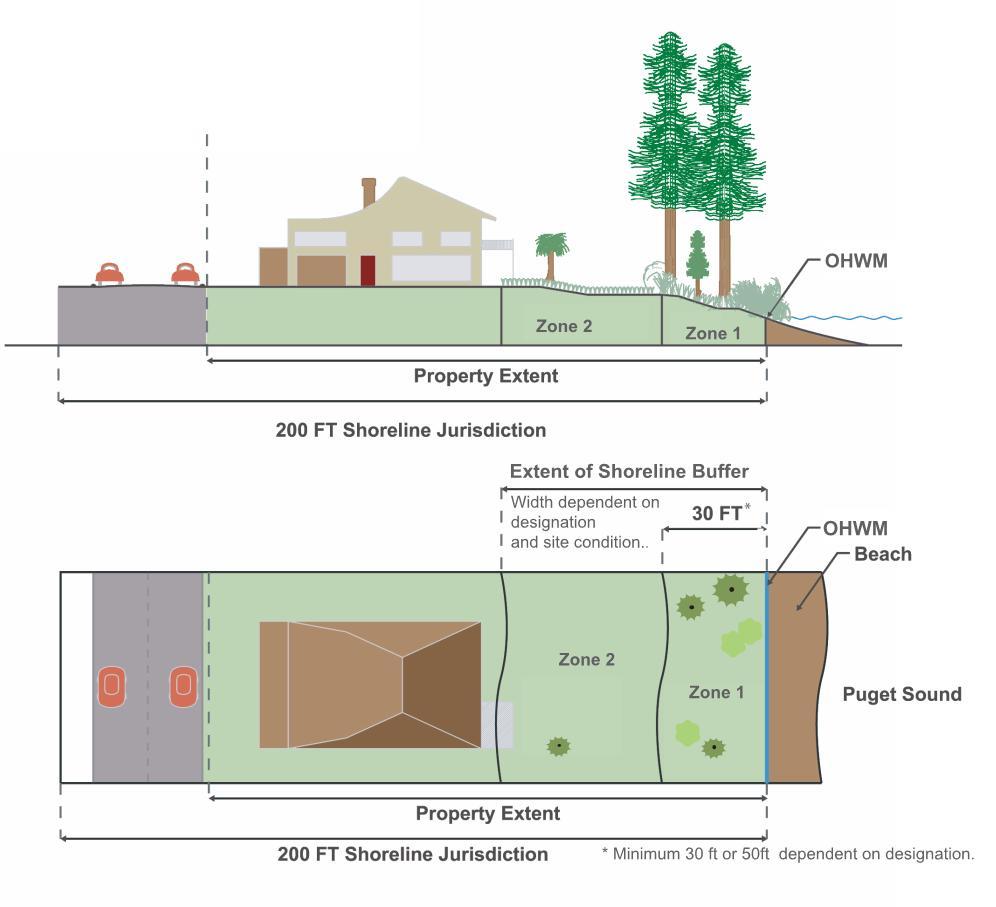
Figure 16.12.030-1 Dual Shoreline Buffer
e. Regulations – General Vegetation Alterations in Shoreline Buffers or Site-Specific Vegetation Management Areas.
i. The following activities are allowed within the shoreline buffer and site-specific vegetation management area with an approved clearing permit. Such activities shall meet the standards of subsection B.4 of this section, Land Modification.
(A) Existing landscape areas may be retained within the shoreline buffer or site-specific vegetation management area. However, any changes from the existing landscape to a different landscaping use or activity will require that the modified area comply with the provisions of subsection B.3 of this section, Vegetation Management, and the intent of providing native vegetation to maintain ecological functions and processes.
(B) Minor Pruning. Tree pruning, including thinning of lateral branches to enhance views, or trimming, shaping, thinning or pruning necessary for plant health and growth and which does not harm the plant, is allowed consistent with the following standards:
(1) All pruning shall meet the American National Standard Institute (ANSI) tree pruning standards;
(2) In no circumstance shall removal of more than one-fourth of the original crown be permitted within a three-year period;
(3) Pruning shall not include topping, stripping of branches or creation of an imbalanced canopy; and
(4) Pruning shall retain branches that overhang the water.
(C) Vegetation Removal Related to Construction. Tree or vegetation removal within the shoreline buffer or site-specific vegetation management area that is associated with new construction may be allowed, but must retain significant trees and shall meet the requirements of subsection B.2 of this section, Environmental Impacts, including replanting provisions.
(D) Vegetation Removal Related to Public Facility Maintenance. Tree or vegetation removal within the shoreline buffer or site-specific vegetation management area that is associated with maintenance of existing public facilities (including: roads, paths, bicycle ways, trails, bridges, sewer infrastructure facilities, storm drainage facilities, fire hydrants, water meters, pumping stations, street furniture, potable water facilities, and other similar public infrastructure), may be approved by the administrator if no significant trees are removed, the requirements of subsection B.2 of this section, Environmental Impacts, are met, and the maintenance measures meet the goals and policies of subsection B.3 of this section, Vegetation Management, or as approved in a SOP manual as provided in subsection B.3.c.vii of this section. The following activities are exempt from this requirement:
(1) Removal of vegetative obstructions required for sight distance and visual clearance at street intersections provided in the Public Works Design and Construction Standards and Specifications.
(E) Underground Utilities. Utilities that run approximately perpendicular to the buffer (for example, a stormwater tightline to the water to protect a slope or a sewer line to a marina) may be allowed within the shoreline buffer or site-specific vegetation management area; provided, that disturbance is minimized and the disturbed area is revegetated after construction; and
(F) Other Approved Development in the Shoreline Buffer or Site-Specific Vegetation Management Area.
(1) Potable water wells; and
(2) Approved shoreline stabilization.
ii. Shoreline Buffer Reductions.
(A) When the prescriptive buffer depth is reduced or dimensions altered through provisions of this program, the applicant shall record a notice on title, or other similar document, with the county auditor prior to permit issuance, subject to the approval of the administrator.
(B) If the required depth of a shoreline buffer for a single-family residential property is reduced in accordance with the shoreline structure setback provisions of subsection B.3.i of this section or other reductions allowed through this program, Zone 1 must be restored in accordance with provisions of subsection B.2.c of this section.
iii. Stairways to the shoreline shall not exceed 300 square feet for private use, the minimum necessary for public use and are not included in the total square footage allocations prescribed in subsection B.3.f.ii of this section.
(A) A larger stairway serving a single-family residence may only be allowed through approval of a shoreline variance.
(1) As an alternative to a stairway larger than 300 square feet and to reduce environmental impacts, a tram may be allowed without a variance.
(B) Stairway design shall meet the following minimum criteria:
(1) International Codes for:
(a) Hand railings;
(b) Stairway width; and
(c) Tread depth.
(2) Landings are required, unless demonstrated not to be necessary, and shall be determined by:
(a) Existing site topography;
(b) Personal safety; and
(c) Slope stability.
f. Vegetation Alterations Standards – Residential Development. Minor clearing, grading or construction may be allowed within the shoreline buffer or site-specific vegetation management plan for a residential development with approval of the administrator pursuant to subsection B.3.e.i.A of this section, and only for the following activities as prescribed below and pursuant to subsection B.4 of this section, Land Modification:
i. Maintenance of existing residential landscaping is allowed subject to subsections B.3.c.viii and e.ii of this section. One hand installed pervious trail to the shoreline not more than four feet in width, which may include hand installed steps, and shall be designed to minimize environmental impacts. No significant trees shall be removed. The trail may be wider when required for handicapped or public access. For single-family residential development vegetation trimming is limited to two feet on either side of the trail.
ii. Nonhabitable structures appurtenant to a single-family use, such as a boat house, deck/patio and/or stairway, may be allowed consistent with the following standards, except that all structures are prohibited in Zone 1 when upland of a priority aquatic – Category A designation.
(A) For site-specific vegetation management areas, the total square footage of all buildings or structures must not exceed 300 square feet in area.
(B) For shoreline buffer areas, the total square footage of all buildings or structures must not exceed 400 square feet or 10 percent of the shoreline buffer area, whichever is less.
(C) For shoreline buffer areas, only 10 percent of the total allowed square footage or 300 square feet, whichever is less, can be located in Zone 1, except when upland of priority aquatic B, the total allowable square footage is five percent of Zone 1 or 150 square feet, whichever is less.
(D) All structures must be designed to not significantly impact views from adjoining property primary buildings.
(E) All structures must meet the following standards:
(1) Only water-related structures are allowed within 30 feet of the OHWM or in Zone 1, including a boathouse, permeable deck, boat storage, or staircase.
(2) Shall not exceed 12 feet in height above existing grade.
(3) Decks and/or patios shall be permeable and shall not exceed 30 inches in height above existing grade.
iii. View Maintenance – Single-Family Residential Only. Shoreline residential use and development shall use all feasible techniques to maximize retention of existing native shoreline vegetation within the shoreline buffer and the site-specific vegetation management area.
(A) Limited removal of existing trees or vegetation located on the same property as a single-family residence may be allowed for maintenance of a preexisting view from the primary structure, or to establish a view for a new primary structure, provided the following are met:
(1) The applicant demonstrates to the satisfaction of the administrator that the vegetation removal is the minimum necessary to reestablish or establish a view of the water similar to that enjoyed by other residences in the area and that pruning methods are not sufficient to provide an adequate view of the water similar to that enjoyed by other residences in the area; and
(2) Existing significant native trees are not removed within the shoreline jurisdiction, unless exempt; and
(3) In no instance, including accounting for other approved alterations as provided in subsection B.3 of this section, shall vegetation removal exceed 20 percent of the required shoreline buffer area or site-specific vegetation management area or reduce the vegetation canopy coverage to less than 65 percent in the shoreline buffer or vegetation management area.
(a) Vegetation removal occurring adjacent to the shoreline shall also be limited to 15 linear feet of the water frontage; and
(4) Documentation of compliance with the development standards in subsection B.5.k of this section provided by a licensed geotechnical engineer for any vegetation alteration in a geologically hazardous area. The cost and preparation of the plan is the responsibility of the applicant; and
(5) All vegetation removal complies with other applicable requirements of this program (such as clearing and grading, forest practices, and protection standards for fish and wildlife habitat), including the no net loss and/or revegetation standards in subsection B.2 of this section.
(B) The administrator may deny a request or condition approval for vegetation alteration proposals for view maintenance if it is determined that the action will result in an adverse effect to any of the following:
(1) Slope stability;
(2) Habitat value;
(3) Health of surrounding vegetation;
(4) Risk of wind damage to surrounding vegetation;
(5) Nearby surface or groundwater; or
(6) Water quality of a nearby water body.
g. Vegetation Alteration Standards – Commercial and Industrial Development in Shoreline Buffers. Minor clearing, grading, or construction may be approved within the shoreline buffer for a commercial or industrial development with approval of the administrator pursuant to subsection B.3.e.i.A of this section and only for the following activities as prescribed below and pursuant to subsection B.4 of this section, Land Modification:
i. Primary appurtenant structures to a commercial use that either support public access or are necessary to support a water-dependent use shall be allowed within the buffer when the applicant has demonstrated a need for the shoreline location, except that all structures are prohibited in Zone 1 when upland of a priority aquatic designation.
ii. When appurtenant structures are allowed they must be the minimum necessary to meet the needs of the water-dependent use or public access requirements of subsection C.4 of this section, Public Access – Visual and Physical.
h. Vegetation Alteration Standards – Public Park Development in Shoreline Buffers. Minor clearing, grading, or construction may be allowed within the shoreline buffer for a public park development with approval of the administrator consistent with the following or pursuant to subsection B.3.e of this section:
i. Vegetation clearing and maintenance is allowed in accordance with an approved SOP manual that meets subsection B.3.c.vii of this section and the standards of this program.
ii. Maintenance of existing public trails, provided the vegetation trimming is limited to two feet on either side of the trail and no significant trees are removed.
iii. Alterations that are included in a park development or concept plan. Minor clearing, grading, or construction for which the size and extent of proposed disturbed areas located within the shoreline buffer have been determined as part of a park development plan or concept park plan, with due consideration of the intended park use; and provided all proposed disturbance areas meet the no net loss standards pursuant to and in accordance with subsection B.2 of this section, Environmental Impacts; and provided appropriate permits are obtained, including those pursuant to subsection B.4 of this section, Land Modification.
iv. Alterations that are not part of a park development or concept plan. The following minor clearing, grading, or construction activities may be allowed without an approved park development plan or conceptual park plan:
(A) Maintenance of existing public trails is allowed, provided maintenance is limited to the existing size of the trail, any vegetation trimming is limited to four feet on either side of the trail, and no significant trees are removed.
(B) New public pathways or trails to the shoreline, provided it is demonstrated that the size and extent of the public pathways has been determined with due consideration of the intended park use.
(C) Structures.
(1) Primary appurtenant structures to a public park and recreational use that either support public access or are necessary to support a water-dependent recreation use shall be allowed within the shoreline buffer when a need for the shoreline location is demonstrated, except that all structures are prohibited in Zone 1 when upland of a priority aquatic designation. When appurtenant structures are allowed, they must be the minimum necessary to meet the needs of the water-dependent use or public access requirements of subsection C.4 of this section, Public Access – Visual and Physical.
(2) The total square footage of all buildings or structures must not exceed 6,000 square feet or 10 percent of the shoreline buffer area, whichever is less.
(a) Only 10 percent of the total allowed square footage or 1,000 square feet, whichever is less, can be located in Zone 1.
(3) All structures must be designated to not significantly impact views from adjoining property primary buildings.
(4) All structures must meet the following standards:
(a) Only water-related recreational furniture, amenities and structures are allowed in Zone 1, including but not limited to picnic tables, benches, interpretive kiosks, viewing platforms, boardwalks, pervious trails or staircases; recreational furniture, signs, pervious trails, and staircases are not included in the maximum square footage allocations prescribed in subsection B.3.h.iv.C.2 of this section;
(b) Accessory recreation buildings, including restrooms, picnic pavilions and service roads that serve such structures, may be allowed in Zone 2 and buildings shall not exceed 12 feet in height above existing grade;
(c) Stairways may exceed 300 square feet; provided, that it is demonstrated that a greater area is necessary to meet public access and public use demands. Stairways shall conform to the standards of the building code as adopted in Chapter 15.04 BIMC; and
(d) Boat ramps and other boating facilities may be allowed pursuant to BIMC 16.12.040.C, Boating Facilities.
i. Regulations – Shoreline Structure Setback View Requirement.
i. To protect existing predominate shoreline views and accommodate shoreline views for a new single-family primary residential structure or addition to a primary residential structure, the administrator may allow Zone 2 of the shoreline buffer to be altered when there is an existing primary residential structure located within 100 feet of the property line of the subject property and topographical or other relevant information indicates that the view of the shoreline from the subject property or the adjacent residence would be impacted by existing or proposed development. The shoreline structure setback line may also require that new structures be set farther away from the shoreline to preserve existing views enjoyed by an adjoining single-family primary structure that was established earlier. These provisions apply to single-family residences only, except in the Point Monroe District.
(A) Setbacks for the purpose of this subsection are based on the location of primary residential structure(s) existing at the time a new primary residential building permit is submitted. A primary residential structure constructed in compliance with the required shoreline setback is not made nonconforming by the later construction of a primary residential structure in a different location on an adjoining lot.
(B) The shoreline structure setback provisions apply only to primary single-family residential structures located within the 200-foot shoreline jurisdiction, where an existing primary single-family residential structure is located within 100 feet of the subject property line. All measurements are to the closest primary residential structure on either side of the subject property as measured parallel to the shoreline.
(C) In determining the shoreline structure setback line, the administrator may also consider topography or other physical property constraints in addition to the provisions of subsections B.3.i.iv and v of this section. Applicants may submit detailed information regarding how property constraints impact the predominant shoreline views from either the subject property’s proposed primary residential structure or adjoining properties’ primary residential structure(s).
ii. The shoreline buffer on the subject property may be reduced below the depth requirements identified in Table 16.12.030-3 to allow a new primary residential structure to be located within Zone 2, provided the conditions in subsection B.3.e.ii of this section are met. Mitigation of proposed residential development shall be required pursuant to subsection B.2 of this section, Environmental Impacts.
iii. In no case shall the subject property be permitted to locate a new primary residential structure within the site’s specified Zone 1 of the shoreline buffer, unless a shoreline variance is granted.
iv. Adjoining Development Located Within Shoreline Buffer. The setback requirement for the subject property shall be based on the location of the adjoining properties’ primary residential structure(s) as described in subsections B.3.i.iv.A through C of this section:
(A) Primary Residential Structure Located on One Side. When an existing primary residential structure is located on one side of the subject property, the shoreline structure setback line shall be determined as follows:
(1) If the adjoining primary residence is partially or wholly located within Zone 2, the shoreline setback line is determined by drawing a line from the most waterward point of the adjoining primary residential structure to the point at which the subject property’s shoreline buffer boundary intersects the subject property’s opposite property line. (See Figure 16.12.030-2 below.)
(2) If the adjoining primary residence is located partially or wholly in Zone 1, the shoreline structure setback line shall be determined by drawing a line from the point of intersection of the subject property and the adjoining property’s Zone 1 boundary, to the point at which the subject property’s shoreline buffer boundary intersects the subject property’s opposite property line. (See Figure 16.12.030-3 below.)
(B) Primary Residential Structure Located on Both Sides. When existing primary residential structures are located on both sides of the subject property, the shoreline structure setback line shall be determined as follows:
(1) If both the adjoining primary residential structures are located partially or wholly in Zone 2, then the shoreline structure setback line shall be determined by drawing a line between the most waterward points of each of the adjoining primary residential structures. (See Figure 16.12.030-4 below.)
(2) If one of the adjoining primary residences is partially or wholly in Zone 1, and the other adjoining primary residence is partially or wholly in Zone 2, the shoreline structure setback line shall be determined by drawing a line from the point of intersection of the subject property and the adjoining property’s Zone 1 boundary (for that adjoining residence located in Zone 1), to the most waterward point of the other adjoining primary residential structure located in Zone 2. (See Figure 16.12.030-5 below.)
(3) If both of the adjoining primary residences are located partially or wholly within Zone 1, the shoreline structure setback line shall be determined by drawing a line from the point of intersection of the subject property’s Zone 1 boundary and the adjoining property’s Zone 1 boundary to the same intersection point on the subject property’s opposite property line. (See Figure 16.12.030-6 below.)
(C) Primary Residential Structure Located on a Shoreline Forming a Cove or Headland. The administrator shall make the determination whether a shoreline forms a cove or headland. When existing primary residential structures are located on a cove or headland, the shoreline structure setback line shall be determined as follows:
(1) If there is a primary residential structure on only one side of the subject property, then the shoreline structure setback line for the subject property shall be either the distance from the OHWM to the most waterward portion of the primary residence structure of the adjoining property, or the subject property’s Zone 1, whichever is greater. (See Figure 16.12.030-7 below.)
(2) If there are adjoining primary residential structures located on both sides of the subject property, the shoreline structure setback line shall be determined by averaging the distance from the OHWM to the most waterward portion of the two adjoining property’s primary residential structures. (See Figure 16.12.030-8 below.)
v. Adjoining Development Located Outside the Shoreline Buffer. The setback requirement for the subject property shall be based on the location of the adjoining properties’ primary residential structure(s) as described in subsections B.3.i.v.A and B of this section:
(A) Primary Structure Located on One Adjoining Property, Outside Shoreline Buffer. When an existing primary residential structure is located on one side of the subject property, the shoreline structure setback line shall be determined by drawing a line from the most waterward point of the primary residential structure of the adjoining property to a point at which the subject property’s shoreline buffer boundary intersects the subject property’s opposite property line. (See Figure 16.12.030-9 below.)
(B) Primary Structures Located on Both Adjoining Properties, Outside the Shoreline Buffer. When existing primary residential structures are located on both sides of the subject property, the shoreline structure setback line shall be determined by drawing a line between the most waterward points of each of the adjoining primary residential structures. (See Figure 16.12.030-10 below.)
(C) Primary Structures Located on Both Adjoining Properties, Outside the Shoreline on a Cove or Headland. When existing primary residential structures are located on both sides of the subject property, the shoreline structure setback line shall be determined by averaging the distance from the OHWM to the most waterward portion of the two adjoining property’s primary residential structures. (See Figure 16.12.030-11 below.)
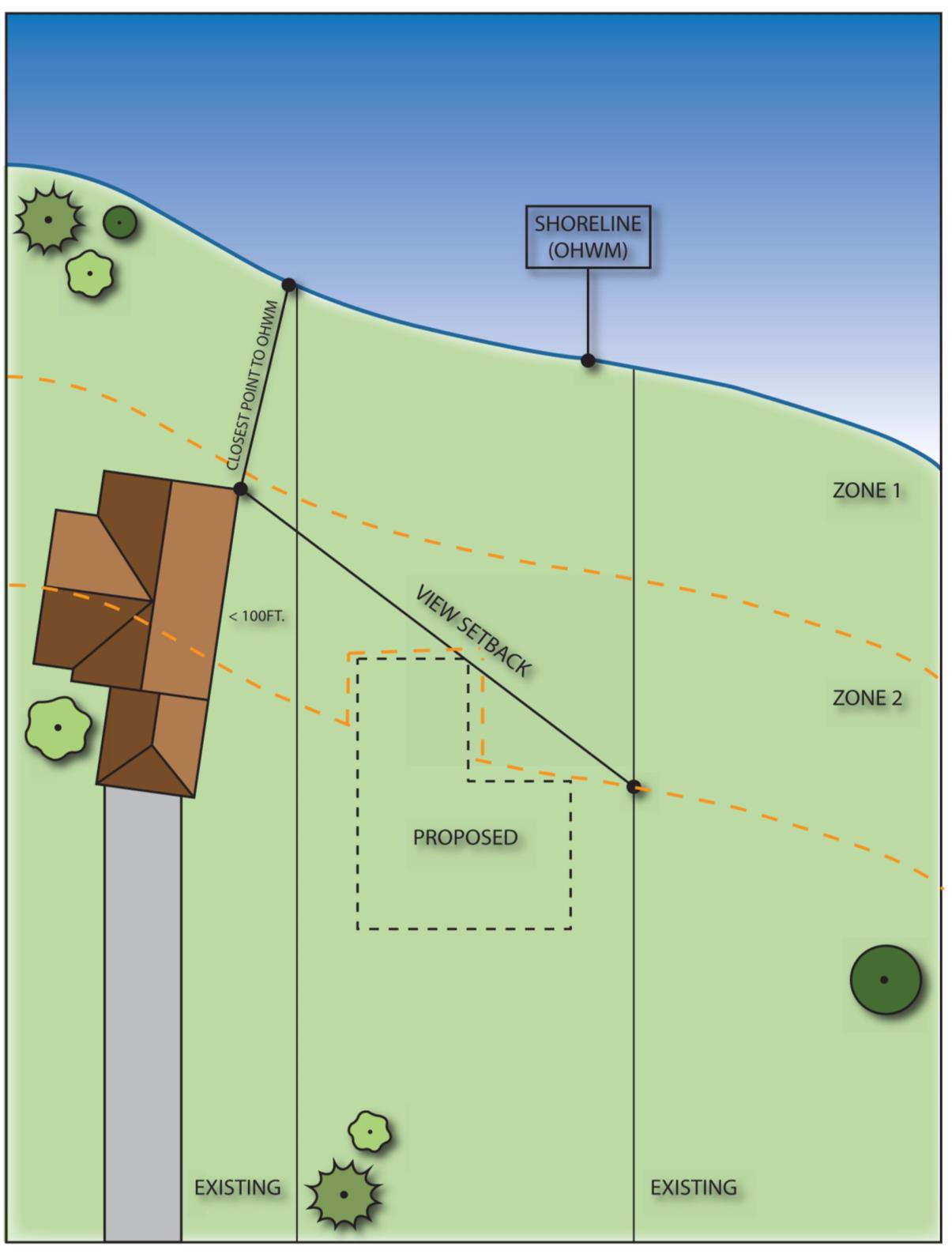
Figure 16.12.030-2
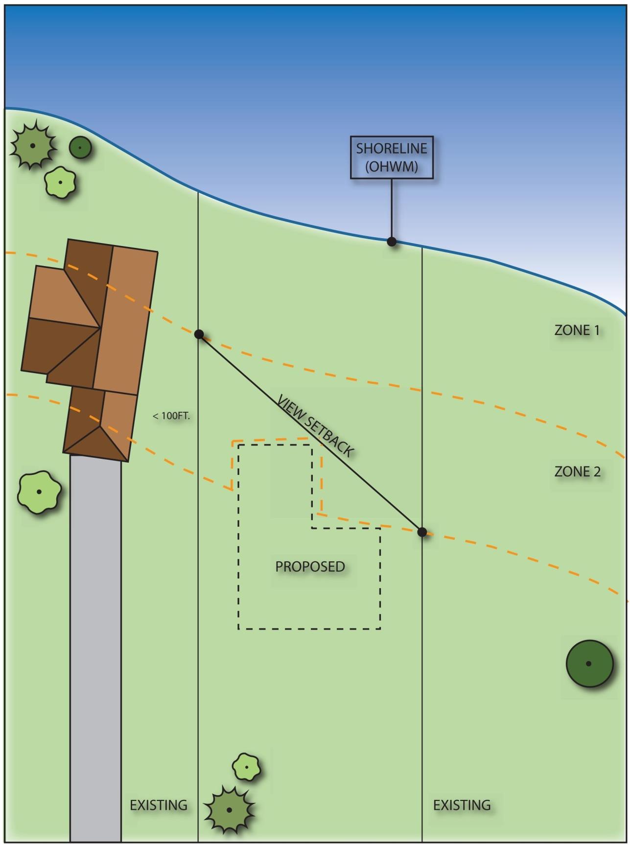
Figure 16.12.030-3
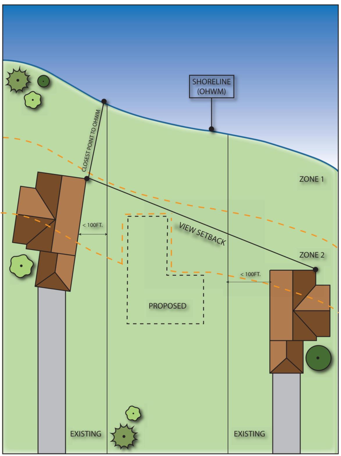
Figure 16.12.030-4
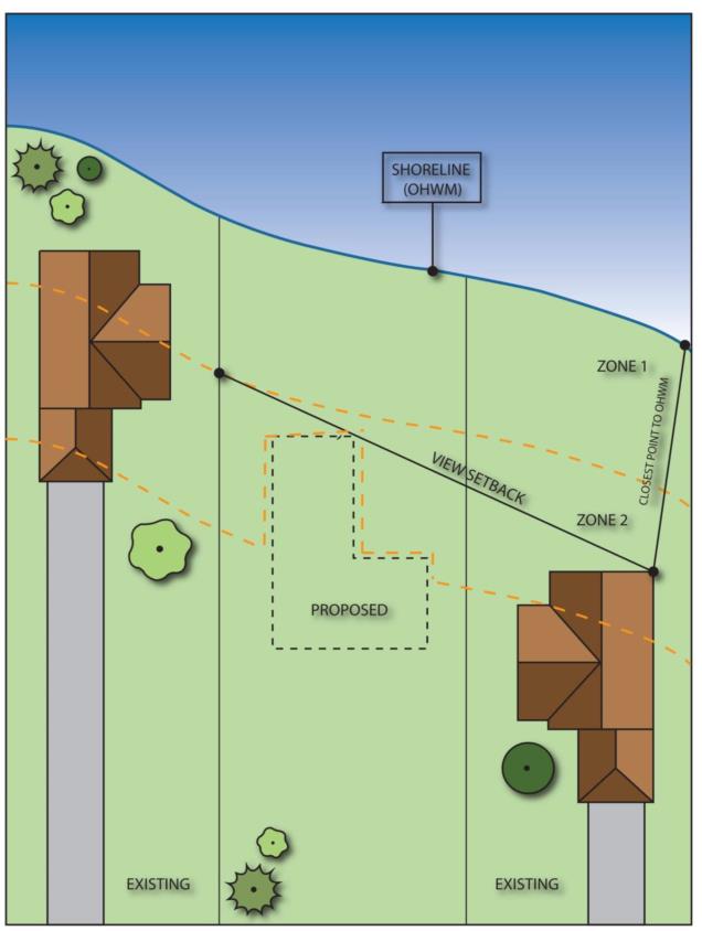
Figure 16.12.030-5
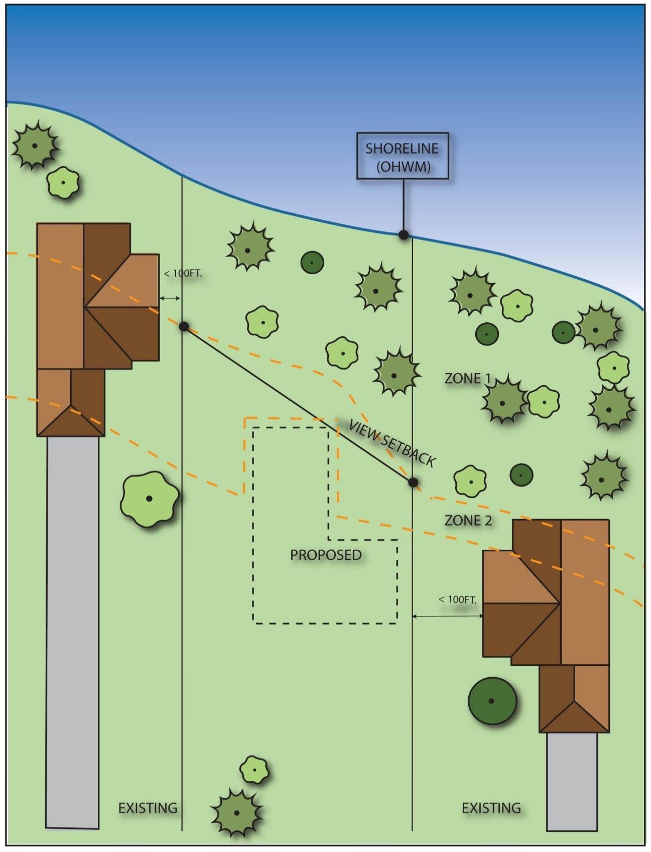
Figure 16.12.030-6
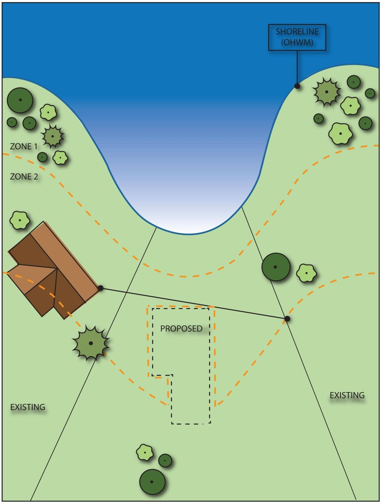
Figure 16.12.030-7
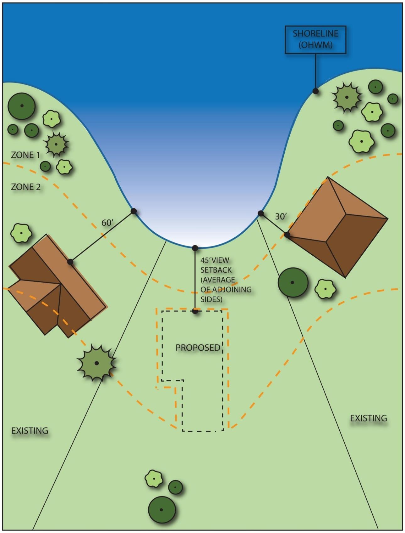
Figure 16.12.030-8
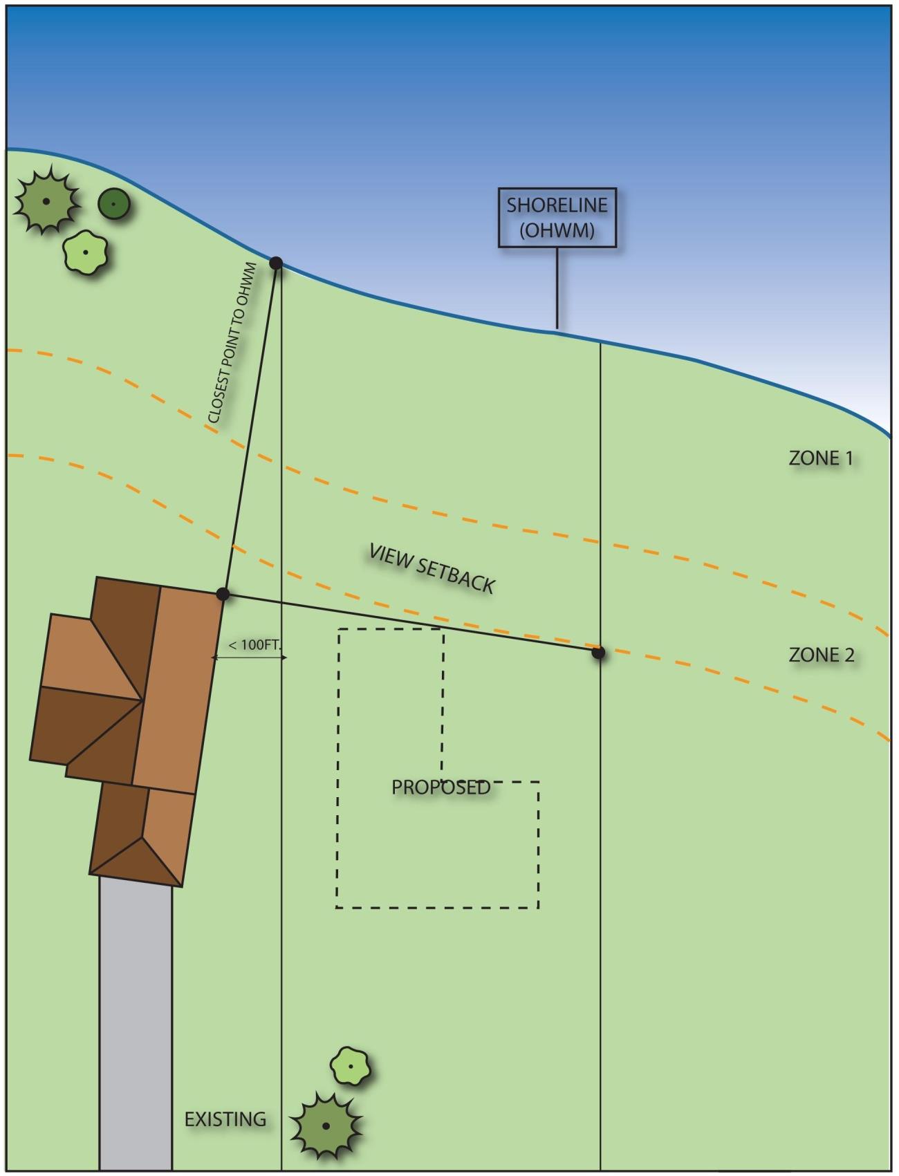
Figure 16.12.030-9
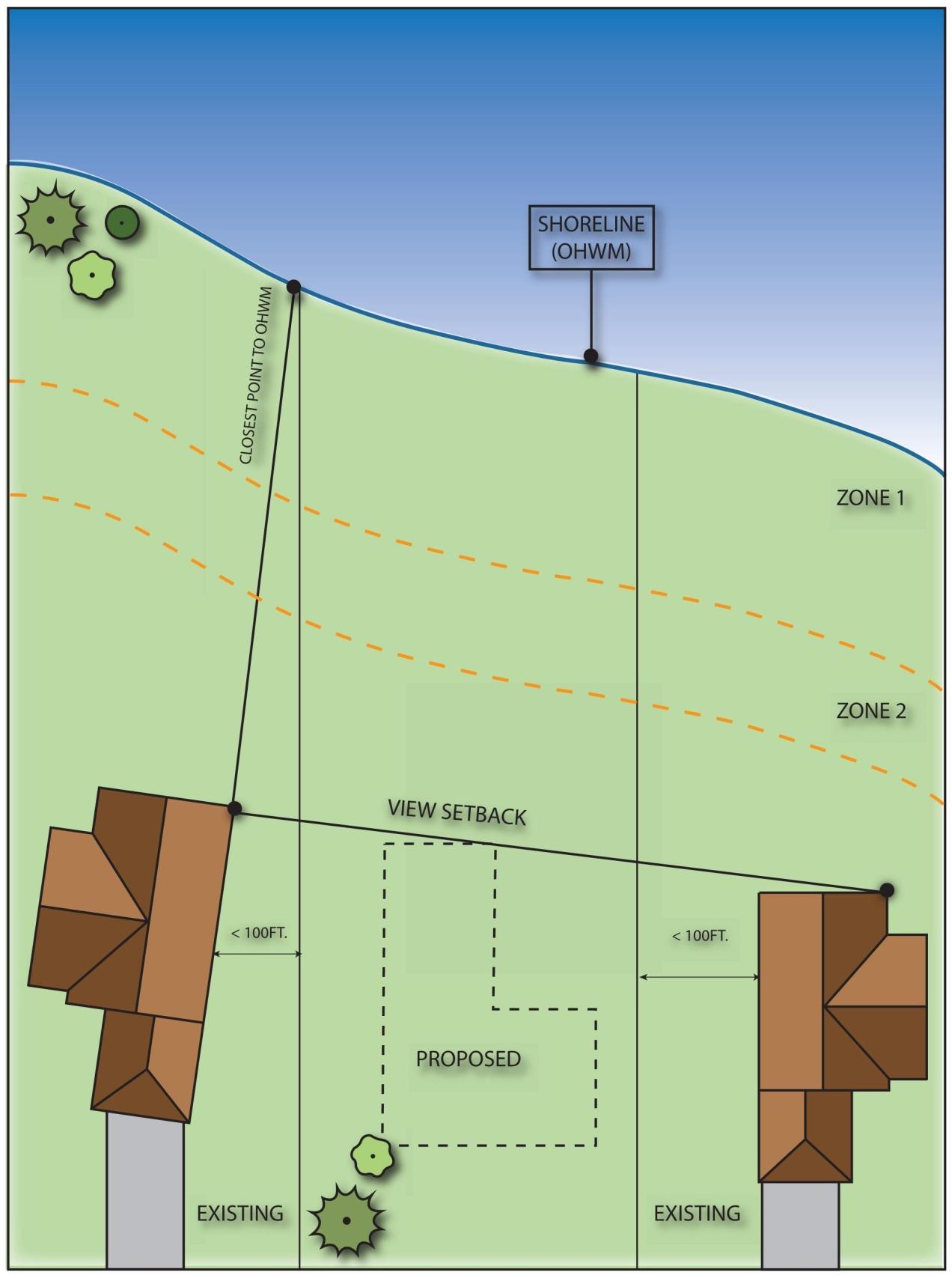
Figure 16.12.030-10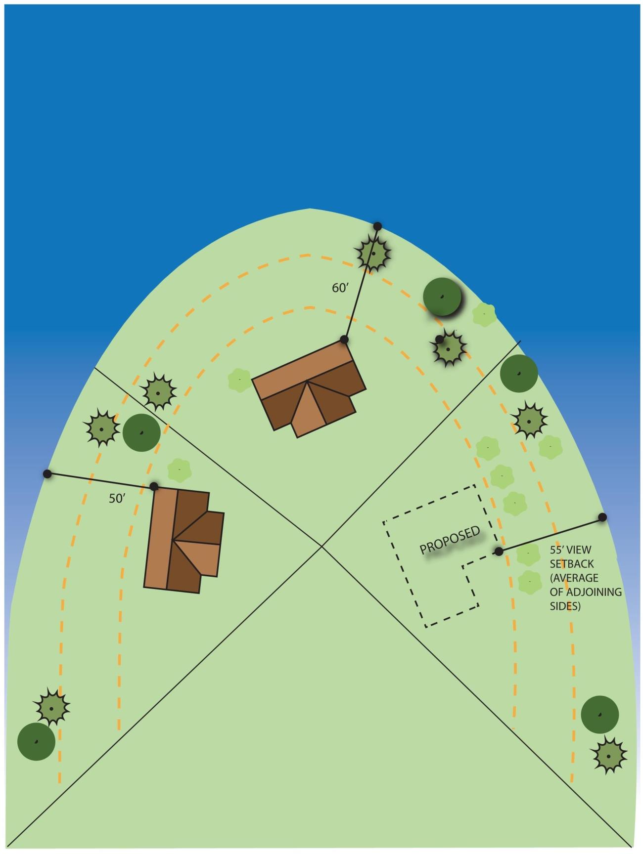
Figure 16.12.030-11
4. Land Modification.
a. Applicability. All shoreline uses and activities must conform to the clearing and grading provisions herein, including development which does not require a shoreline permit. Shoreline development and land modification activities will be reviewed under the no net loss provisions of subsection B.2 of this section, Environmental Impacts, and may also be reviewed under subsection A of this section, Regulations – General; subsection B.3 of this section, Vegetation Management; subsection B.5 of this section, Critical Areas; subsection B.6 of this section, Water Quality and Stormwater Management; and Chapter 15.18 BIMC, Land Clearing, when applicable. Other portions of this program may also apply.
b. Regulations – Prohibited.
i. All clearing and/or grading not associated with an approved development, use or activity, unless specifically provided for in this program.
c. Regulations – General.
i. Clearing and/or grading within shoreline jurisdiction shall require an approved clearing or grading permit in association with an existing legal use or a new permitted or allowed shoreline use or development. Such activities shall meet the mitigation and revegetation provisions in subsection B.2 of this section, Environmental Impacts, and subsection B.3 of this section, Vegetation Management.
ii. Upon completion of development, use or activity, the remaining cleared areas shall be replanted within the first applicable planting season.
iii. All vegetation that is intended to be retained but may likely be disturbed by the clearing and grading activity shall be protected in accordance with the standards of BIMC 18.15.010, Landscaping, screening, and tree retention, protection and replacement.
iv. Land alteration (clearing, grading, and filling) shall be limited to the minimum extent necessary for the proposed development, use or activity. All land alteration must meet the standards of Chapter 15.20 BIMC, Surface and Stormwater Management.
5. Critical Areas.
a. Applicability. This section provides policies and regulations that apply to critical areas located within the shoreline jurisdiction, including wetlands, streams, geologically hazardous areas, frequently flooded areas, fish and wildlife habitat conservation areas, and critical saltwater habitat. This section applies to all development, uses and activities within areas or adjacent to areas designated as critical areas. No action shall be taken by any person, company, agency, governmental body (including the city), or applicant, which results in any alteration of a critical area except as consistent with the goals, policies, purposes, intent, requirements, and development standards of this section.
b. Goal. Comprehensively manage shoreline uses and activities to protect, enhance, and restore existing ecological functions and ecosystem-wide processes of critical areas by utilizing the most current, accurate, and complete scientific and technical information. By avoiding and limiting adverse impacts to and alteration of critical areas, this section seeks to protect the Island’s special character and accomplish the following goals:
i. Conserve the biodiversity of plant and animal species, protect, maintain and restore healthy, functioning ecosystems through the protection of unique, fragile, and valuable elements of the environment, including, but not limited to, ground and surface waters, wetlands, fish and wildlife and their habitats;
ii. Direct development, uses and activities to less environmentally sensitive sites and mitigate unavoidable impacts to critical areas by regulating alterations in and adjacent to critical areas;
iii. Prevent cumulative adverse environmental impacts to water quality, water quantity, wetlands, and fish and wildlife habitat, and the overall net loss of wetlands, frequently flooded areas, aquifer recharge, and habitat conservation areas;
iv. Protect members of the public and public resources and facilities from injury, loss of life, or property damage due to landslides and steep slope failures, erosion, seismic events, or flooding; and
v. Alert owners, potential purchasers, real estate agents, appraisers, lenders, builders, developers and other members of the public to natural conditions that pose a hazard or otherwise limit development.
c. Purpose and Intent.
i. The purpose of this section is to designate and classify ecologically sensitive and hazardous areas as critical areas and to protect, maintain and restore these areas and achieve no net loss of their functions and values.
ii. This section is intended to implement the goals, policies, guidelines, and requirements of the city comprehensive plan and the Shoreline Management Act (Chapter 90.58 RCW).
iii. Critical areas provide a variety of valuable and beneficial biological and physical functions that benefit the city and its residents. Critical areas may also pose a threat to human safety or to public and private property. The beneficial functions and values provided by critical areas include, but are not limited to, water quality protection and enhancement, fish and wildlife habitat, food chain support, flood storage, conveyance and attenuation of flood waters, groundwater recharge and discharge, erosion control, wave attenuation, and protection from hazards and the impacts of climate change. Groundwater recharge is of particular concern for the city because the Island’s drinking water is supplied solely by groundwater.
iv. This section is to be administered with flexibility and attention to site-specific characteristics. It is not the intent of this section to make a parcel of property unusable by denying its owner reasonable use of the property or to prevent the provision of public facilities and services necessary to support existing development. If the provision of this chapter results in the denial of reasonable use of a property, relief can be sought through the shoreline variance permit process.
d. Protection of Critical Areas.
i. All proposed development, uses, and activities subject to this section shall utilize mitigation sequencing pursuant to subsection B.2.d of this section.
ii. The precautionary principle shall be applied in the review of any action, taken or proposed, that does not conform to the requirements of this section. The burden of proof that the action will cause no net loss or harm to persons or property falls on the applicant or the property owner.
e. Policies.
i. Provide a level of protection to critical areas that protects, maintains and restores these areas, and achieves no net loss of their functions and values.
ii. Encourage development proposals to include elements of preservation, conservation, restoration, or enhancement of critical areas, including saltwater habitat and fish and wildlife conservation areas, through incentives and ecosystem-wide restoration planning.
iii. Locate, design, construct, and manage all shoreline uses and activities in ways that assure no net loss of shoreline ecological functions and ecosystem-wide processes, and protect critical saltwater habitat, including fish and wildlife habitat conservation areas.
iv. Locate and design shoreline uses, activities, and/or development to avoid risks to people and property. See also BIMC 16.12.020, Shoreline designation regulations, for additional provisions.
v. Promote water-related shoreline uses and activities, such as public access and recreation, that are compatible with critical areas, provided they do not result in a net loss of critical area functions and values.
f. Allowed Activities Within Critical Areas.
i. The following activities are allowed within critical areas and their buffers and do not require review for compliance with critical area regulations. Any activity not subject to critical areas regulations that constitutes development pursuant to BIMC 16.12.080, Definitions, is subject to applicable review under this program.
(A) Normal and routine yard and garden activities including, but not limited to, cutting and mowing lawns, weeding, removal of noxious and invasive species, harvesting and replanting of garden plants and crops, incidental vegetable gardening, and pruning and planting of noninvasive ornamental vegetation, intended to maintain the general condition and extent of such areas; provided, that such activities are limited to legally existing yard and garden areas, do not further expand into critical areas or associated buffers, do not significantly alter topography, and do not diminish water quality or quantity. Normal and routine activities cannot result in a change to the location, size at the ground level or configuration of existing yard and garden areas.
(B) Class I, II and III forest practices regulated pursuant to Chapter 76.09 RCW.
(C) Minor Site Investigative Work. Work necessary for land use review submittals, such as surveys, soil logs, percolation tests, and other related activities, where such activities do not require a clearing permit pursuant to subsection B.4 of this section or construction of new roads. In every case, impacts to the critical area shall be minimized and disturbed areas shall be immediately restored. Minor site investigative work may include educational and scientific research activities.
(D) Activities Within the Improved Right-of-Way. Replacement, modification, installation, or construction of utility facilities, lines, pipes, mains, equipment, or appurtenances, when such facilities are located within the improved portion of the public right-of-way or easement of a private street, except those activities that alter a wetland or watercourse, such as culverts or bridges, or result in the transport of sediment or increased stormwater.
(E) The installation of low impact fencing within critical area buffers, provided the location does not result in restricting wildlife movement, the location and installation is the least impactful to the critical area and buffer as possible, and there is no alternative to fencing to achieve the purpose of the fence.
(F) Signs for marking critical area boundaries, interpretive signs and survey markers or property boundaries.
(G) Development, uses or activities within critical aquifer recharge areas that do not have the potential to generate a pollutant identified as a potential source of drinking water contamination pursuant to subsection B.5.i of this section and are outside an aquifer recharge protection area (ARPA) if one has been designated pursuant to BIMC 16.20.100 and any other critical area or its buffer or setback.
ii. The following activities are allowed within critical areas and their buffers, without a shoreline variance, after review and authorization by the city. Review and authorization may occur over-the-counter and will require a written letter of approval or shall be reviewed for consistency with this section as part of the required shoreline review or permit. Any activity not subject to critical areas regulations that constitutes development pursuant to BIMC 16.12.080, Definitions, is subject to applicable review under this program.
(A) Activities within a portion of a wetland buffer or fish and wildlife habitat conservation area buffer separated from the critical area by an existing permanent substantial development, use or activity which serves to eliminate or greatly reduce the impact of the proposed activity on the critical area are exempt from establishing the full required buffer width; provided, that impacts to the critical area do not increase. The director shall review the proposal to determine the likelihood of associated impacts and may require the applicant to provide a critical areas report prepared by a qualified professional that demonstrates through a site assessment or functional analysis that the interrupted buffer area is functionally isolated from the critical area. The director shall consider the hydrologic, geologic, and/or biological habitat connection potential and the extent and permanence of the physical separation.
g. Regulations – General.
i. Any proposed development or activity within a critical area or its buffer or setback requiring review under this program shall be reviewed based on the proposal’s ability to comply with all of the following criteria:
(A) The proposal minimizes the impact on critical areas in accordance with mitigation sequencing (subsection B.2.d of this section);
(B) The proposal does not pose an unreasonable threat to the public health, safety, or welfare on or off the development proposal site;
(C) The proposal is consistent with the general purposes of this section and the public interest;
(D) Any alterations permitted to the critical area are mitigated in accordance with mitigation requirements in subsection B.2.d of this section;
(E) The proposal protects the critical area functions and values consistent with best available science and results in no net loss of critical area functions and values;
(F) The proposal addresses cumulative impacts of the action; and
(G) The proposal is consistent with other applicable regulations and standards.
ii. The city may condition the proposed activity as necessary to mitigate impacts to critical areas and to conform to the standards required by this section.
iii. Except as provided for by this section, any project that cannot adequately mitigate its impacts to critical areas in the sequencing order of preferences in subsection B.2.d of this section shall be denied.
iv. Support Information Requirements. Any application for proposed development or activity requiring review under this program shall include the following:
(A) A site plan drawn to scale identifying locations of critical areas and their buffers, location of proposed development, uses and activities, location and estimated quantity of earthwork and vegetation clearing and location and type of drainage features or infrastructure.
(B) Any critical area report or study required by this section. Such reports or studies shall be prepared by qualified professionals in the area of concern as defined in BIMC 16.12.080, Definitions, and in accordance with the requirements provided in subsection B.5.n of this section, Critical Areas Reports, as follows:
(1) Aquifer recharge study: hydrogeologist;
(2) Geological hazard assessment: engineering geologist; geotechnical engineer, provided that:
(a) An engineering geologist may provide a study, including interpretation, evaluation, analysis, and application of geological information and data and may predict potential or likely changes in types and rates of surficial geologic processes due to proposed changes to a location, provided it does not contain recommended methods for mitigating identified impacts, other than avoidance, structural impacts to, or suitability of civil works; and
(b) Engineering geologists may not provide engineering recommendations or design recommendations, but may contribute to a complete geotechnical report that is co-sealed by a geotechnical engineer;
(3) Stream buffer enhancement plan: biologist with stream ecology expertise; fish or wildlife biologist; a civil engineer may provide studies for drainage, surface and subsurface hydrology, and water quality;
(4) Wetland buffer enhancement plan, wetland critical area report, wetland mitigation plan: wetlands specialist;
(5) Habitat management plans: wildlife biologist and/or fisheries biologist;
(6) The director is authorized to retain experts at the applicant’s expense and request review from other jurisdictional agencies to assist in the review of application materials.
(c) Any additional information determined as relevant by the director.
v. Notice on Title.
(A) The owner of any property with field-verified presence of critical area or buffer on which a development proposal is submitted shall file for record with the Kitsap County auditor a notice approved by the director in a form substantially as set forth in subsection B.5.g.v.B of this section. Such notice shall provide notice in the public record of the presence of a critical area and buffer, the application of this section to the property, and that limitations on actions in or affecting such areas may exist. The applicant shall submit proof that the notice has been filed for record before the city shall approve any development proposal for such site. The notice shall run with the land and failure to provide such notice to any purchaser prior to transferring any interest in the property shall be in violation of this section.
(B) Form of Notice.
Critical Areas and/or Critical Areas Buffer Notice
Legal Description: _______________
Present owner: _________________
NOTICE: This property contains critical areas or their buffers as defined by the City of Bainbridge Island Ordinance No. __________.
The property was the subject of a development proposal for (type of permit) application #_______ filed on _______ (date).
Restrictions on use or alteration of the critical areas or their buffers may exist due to natural conditions of the property and resulting regulations. Review of such application has provided information on the location of critical areas or critical area buffers and restrictions on their use through setback areas. A copy of the plan showing such setback areas and other restrictions or required enhancements is attached hereto.
Signature of owner: ____________
STATE OF WASHINGTON)
COUNTY OF ___________)
On this day personally appeared before me to me known to be the individual(s) described in and who executed the within and foregoing instrument and acknowledged that they signed the same as their free and voluntary act and deed for the uses and purposes therein stated.
Given under my hand and official seal this ___________ day of _________.
NOTARY PUBLIC in and for the state of Washington, residing at _________.
h. Regulations – Critical Saltwater Habitat.
i. Water-dependent development and uses, including marinas, docks, piers, mooring areas, underwater parks, utility crossings, and shoreline modifications, shall not intrude into or be built over critical saltwater habitat unless:
(A) The applicant can show that all of the following criteria can be met:
(1) The use preferences of subsection B.1 of this section shall be utilized for uses in shorelines of statewide significance; and
(2) The need for such a structure is clearly demonstrated and an alternative alignment or location on the property that would avoid impacts to critical saltwater habitats is not feasible or would result in unreasonable and disproportionate cost to accomplish the same general purpose, as demonstrated through an alternatives analysis. The analysis should include, in part, shoreline bathymetry, shoreline features at the site, and substrate composition; and
(3) It can be demonstrated that the project is consistent with the state’s interest in resource protection and species recovery; and
(4) Impacts to critical saltwater habitat functions and processes are mitigated to result in equal or better ecological function; or
(B) The proposal is for private, noncommercial, residential docks for single use, community, or joint use, which may be authorized; provided, that:
(1) Avoidance of impacts to critical saltwater habitats by an alternative alignment or location is not feasible; and
(2) The project, including any required mitigation, will result in no net loss of ecological functions and processes associated with critical saltwater habitat;
(C) New or expanded overwater structures shall be located the greater or most protective of:
(1) A horizontal distance of 25 feet from the outside edge of the structure to native aquatic vegetation attached to or rooted in substrate;
(2) A horizontal distance equal to the maximum distance shade will be cast by the structure and vessel;
(3) A four-foot vertical distance from eelgrass or relevant submerged aquatic vegetation;
(4) A distance the diameter of the turning circle, if the structure is to be utilized for motorized vessels. The turning circle is defined as three and one-half times the length of the longest vessel to use the structure;
(5) Alternative measures that demonstrate no net loss of ecological functions;
(D) For projects within WDFW documented Pacific herring spawning locations, in-water activities that would affect herring spawn should be restricted to WDFW’s approved work window for Bainbridge Island (May 1st through January 14th). For aquaculture projects, the city may consider alternative methods that are contained in federal and/or state aquaculture permits for reducing impacts to herring spawning habitat and other forage fish spawning habitat;
(E) For projects other than commercial aquaculture within WDFW documented sand lance and surf smelt spawning locations, no activities should occur during spawning windows as identified by WDFW. For commercial aquaculture projects within WDFW documented sand lance and surf smelt spawning locations, no harvesting may occur during the surf smelt or sand lance spawning seasons until a spawning survey is conducted. If surf smelt or sand lance spawn are present in the growing area to be harvested or adjacent tidelands, then no harvest activities may occur until the eggs are hatched. Extreme caution should be taken to avoid impact and minimize disturbance of sand lance and surf smelt larvae that are present.
ii. Aquatic herbicide treatments, mechanical removal of vegetation or aquatic pesticide treatments shall not be used on critical saltwater habitats, except for approved habitat restoration or enhancement measures that meet the provisions of subsection B.6 of this section, Water Quality and Stormwater Management.
iii. Sand, gravel or other materials shall not be added or removed from critical saltwater habitat, unless approved as part of a restoration effort or beach nourishment program or as allowed in subsection B.5.h.i of this section.
iv. New outfalls (including stormwater and sewer outfalls) and discharge pipes shall not be located in critical saltwater habitats or areas where outfall or discharge will adversely affect critical saltwater habitat, unless the applicant can show that all of the following can be met:
(A) There is no feasible alternative location for the outfall or pipe; and
(B) The outfall or pipe is placed below the surface of the beach or bed of the water body; and
(C) The discharge point(s) on the outfall or discharge pipe is located so the discharges, including nutrients and flow, do not adversely affect critical saltwater habitats; and
(D) For public sewage outfalls:
(1) The outfall discharges waterward of the intertidal zone.
(2) The disturbed area will be revegetated with native vegetation.
v. The use of existing outfalls shall be maximized to limit the need for additional outfalls, provided the existing outfall meets the standards of this section, or unless an alternatives analysis demonstrates the dispersal is less impacting to the shoreline environment.
vi. Until an inventory of critical saltwater habitat is completed, all overwater and near-shore development shall conduct an inventory of site and adjacent beach sections to assess the presence of critical saltwater habitat and/or functions and processes. The inventory shall occur prior to construction and the methods and extent of the inventory shall be consistent with accepted research methodology. New studies shall be required only when existing information is outdated or does not exist.
i. Regulations – Aquifer Recharge Areas.
i. Classification. Aquifer recharge areas are areas that have a critical recharging effect on groundwater used for potable water supplies and/or that demonstrate a high level of susceptibility or vulnerability to groundwater contamination from land use activities. In accordance with WAC 365-190-100, the entirety of Bainbridge Island is classified as an aquifer recharge area to preserve the volume of recharge available to the aquifer system and to protect groundwater from contamination.
ii. Prohibited Activities and Uses.
(A) The following activities and uses are prohibited within critical aquifer recharge areas due to the probability or potential magnitude of their adverse effects on groundwater:
(1) Landfills. Landfills, including hazardous or dangerous waste, municipal solid waste, special waste, wood waste, and inert and demolition waste landfills;
(2) Underground Injection Wells. Class I, III, and IV wells and subclasses 5F01, 5D03, 5F04, 5W09, 5W10, 5W11, 5W31, 5X13, 5X14, 5X15, 5W20, 5X28, and 5N24 of Class V wells;
(3) Chemical wood preservation and/or treatment facilities;
(4) Storage, Processing, or Disposal of Radioactive Substances. Facilities that store (other than minor sources such as medicinal uses or industrial testing devices), process, or dispose of radioactive substances;
(5) Hazardous liquid transmission pipelines;
(6) Commercial mining and chemical washing of metals, hard rock, sand, and gravel;
(7) Hydrocarbon extraction, reprocessing, refinement, and storage;
(8) Electroplating/metal finishing;
(9) Facilities that treat, store, process, or dispose of hazardous waste; and
(10) Other Prohibited Uses or Activities.
(a) Activities that would significantly reduce the recharge to aquifers currently or potentially used as a potable water source; and
(b) Activities that would significantly reduce the recharge to aquifers that are a source of significant baseflow to a stream.
iii. Development Standards – General. No development, use or activity may exceed water quality standards or otherwise violate the anti-degradation requirements specified in Chapter 173-200 WAC.
j. Regulations – Fish and Wildlife Habitat Conservation Areas.
i. Classification. Fish and wildlife habitat conservation areas include:
(A) Within the city of Bainbridge Island, streams shall include those areas which meet the definitions in BIMC 16.12.080, Definitions. Streams shall be classified in accordance with the Washington Department of Natural Resources water typing system (WAC 222-16-030), which is hereby adopted in its entirety by reference and summarized as follows:
(1) Type F: streams which contain fish habitat pursuant to BIMC 16.12.080, Definitions;
(2) Type Np: perennial nonfish habitat streams; and
(3) Type Ns: seasonal nonfish habitat streams.
(B) Habitats recognized by federal or state agencies for federal- and/or state-listed endangered, threatened, sensitive and candidate/monitored species which presence is documented in maps or databases available to the city of Bainbridge Island.
(C) Areas that contain habitats and species of local importance. Any person may nominate for designation a species or habitat of local importance. Nominations will be processed pursuant to definitions in BIMC 16.12.080, Definitions, and nomination criteria developed by the director.
(D) Biodiversity areas and corridors as defined in the 2008 Washington Department of Fish and Wildlife priority habitat and species list, or as amended.
(E) All areas within the city of Bainbridge Island meeting one or more of the preceding criteria in this section, regardless of any formal identification or mapping, are hereby designated critical areas and are subject to the provisions of this section and shall be managed consistent with the best available science, such as the Washington Department of Fish and Wildlife’s most recent management recommendations for priority habitat and species.
ii. Mapping. The location and extent of all mapped critical areas shown on the city of Bainbridge Island critical area maps are approximate and shall be used as a general guide only. The type, extent and boundaries shall be determined in the field by a qualified professional according to the requirements of this section. The critical area maps are adopted as part of this section and are incorporated herein by this reference. Washington Department of Natural Resources (DNR) and Washington Department of Fish and Wildlife maps are not the only source of data. Any request to change the city’s existing map shall be accompanied by a report from a qualified professional that includes a description of the critical area and a summary of how it meets the definitions in BIMC 16.12.080, Definitions. The inventory and cited resources are to be used as a guide for the city, project applicants, and/or property owners and may be continuously updated as new or altered critical areas are identified.
iii. Development Standards – Stream Buffers.
(A) All designated streams require a buffer pursuant to Table 16.12.030-4. Buffers shall remain as undisturbed or enhanced vegetation areas for the purpose of protecting the integrity, function, and value of stream resources. Any buffer modification proposed shall be through an approved buffer enhancement plan. No uses or activities shall be allowed within the buffer unless allowed by this section. If the buffer has previously been disturbed, the director may require the disturbed buffer area be enhanced, including revegetation with native plant species, pursuant to an approved buffer enhancement plan meeting the requirements of subsection B.5.n.iv of this section. No refuse, including but not limited to household trash, yard waste and commercial/industrial refuse, shall be placed in the buffer.
(B) The required minimum buffers listed in Table 16.12.030-4 are based on the assumption that the buffer is well vegetated with native species appropriate to the site. If the buffer does not consist of vegetation adequate to provide stream protection and buffer functions, the director may require that the buffer be planted to achieve such protection and function.
Table 16.12.030-4: Stream Buffers
|
Stream Type |
Buffer Width |
|---|---|
|
F |
200' |
|
Np |
100' |
|
Ns (connected to F or Np) |
75' |
|
Ns (not connected to F, Np) |
50' |
(C) Buffer distances shall be measured from the ordinary high water mark (OHWM) or from the top of each bank where the OHWM cannot be identified.
(D) The buffer width shall be increased to include streamside wetlands which provide overflow storage for stormwater, feed water back to the stream during low flow, or provide shelter and food for fish. In braided channels, the ordinary high water mark or top of bank shall be defined to include the entire stream feature.
(E) For streams in ravines outside the mixed use town center with ravine sides 10 feet or greater in height, the buffer width shall be the greater of:
(1) The buffer width required for the stream type; or
(2) A buffer width which extends 25 feet beyond the top of the ravine.
(F) The director may increase buffer widths, up to 50 percent greater than the applicable buffer set in this section for critical areas with known locations of endangered, threatened, or state monitored or priority species for which a habitat management plan indicates a larger buffer is necessary to protect habitat values for such species. Such determination shall be based on site-specific and project-related conditions.
(G) A structure or hard surface setback line of 15 feet is required from the edge of any stream buffer. Minor structural or impervious surface intrusions into the areas of the setback, such as but not limited to fire escapes, open/uncovered porches, landing places, outside walkways, outside stairways, retaining walls, fences and patios, may be permitted if the department determines upon review of an analysis of buffer functions submitted by the applicant, that construction and/or maintenance of such intrusions will not encroach into the stream buffer or adversely impact the stream. The functional analysis shall include a functional methodology supported by best available science. The setback shall be identified on a site plan and filed as an attachment to the notice on title as required by subsection B.5.g.v of this section, Notice on Title.
(H) Modification to buffer widths may be allowed provided the applicant demonstrates the need for modification through mitigation sequencing pursuant to subsection B.2.d of this section.
(1) The width of a required buffer may be averaged if the applicant can demonstrate that averaging can provide equal or greater functions and values as would be provided under the required buffer and all of the following conditions are met:
(a) The total area of buffer after averaging is equal to the area required without averaging.
(b) Averaging does not result in any portion of the buffer being reduced more than 25 percent of its required width.
(2) Any request for buffer modification outlined above shall be reviewed in conjunction with the underlying land use or construction permit. Requests for buffer reduction shall include a buffer enhancement plan prepared by a qualified consultant that meets the requirements of BIMC 16.12.080, Definitions.
(3) The city may request technical review of a buffer enhancement plan from other agencies to ensure consistency with state, federal or tribal management recommendations.
(4) Any other buffer modification, other than noncompensatory enhancement, requires a shoreline variance.
iv. Development Standards – Other Fish and Wildlife Habitat Conservation Areas.
(A) All development, uses and activities within known fish and wildlife habitat conservation areas require submittal and approval of a habitat management plan (HMP) as specified in subsection B.5.n.iii of this section. The HMP shall consider measures to retain and protect the fish and wildlife habitat and shall consider the effects of land use intensity, buffers, setbacks, impervious surfaces, erosion control and retention of existing native vegetation.
(B) In the case of bald eagles, the HMP shall comply with the Federal Bald and Golden Eagle Protection Act (16 U.S.C. 668) to avoid impacting eagles and their habitat.
v. Development Standards – Specific Development, Uses, and Activities. The following development, uses, and activities may be allowed within fish and wildlife habitat conservation areas and their buffers. Any proposal for the following development shall comply with the standards of this section, other applicable sections of this program, and other applicable state, federal and local regulations. The director may require submittal of a habitat management plan unless project impacts are demonstrated to be de minimis through mitigation sequencing pursuant to subsection B.2.d of this section.
(A) Stream Crossings.
(1) Any private or public road or driveway expansion or construction proposed to cross streams classified within this section shall comply with the following minimum development standards. All other state and local regulations regarding water crossing structures shall apply, and the use of the water crossing design guidelines (WDFW, 2013), or as amended, is encouraged.
(a) Bridges or bottomless culverts shall be required for all Type F streams. Other alternatives may be allowed upon (i) submittal of a habitat management plan which demonstrates that other alternatives would not result in significant impacts to the fish and wildlife conservation area and (ii) as determined through the hydraulic project approval (HPA) process administered by the Washington Department of Fish and Wildlife. The plan must demonstrate that fish habitat will not be reduced in area or function;
(b) Crossings shall not occur in fish-bearing streams unless no other feasible crossing site exists. For new development proposals, if existing crossings are determined to adversely impact salmon spawning or passage areas, new or upgraded crossings shall be located as determined necessary through coordination with Washington Department of Fish and Wildlife;
(c) Bridge piers or abutments shall not be placed in either the floodway or between the ordinary high water marks unless no other feasible alternative placement exists;
(d) Crossings shall not diminish flood carrying capacity;
(e) Crossings shall serve multiple properties whenever possible;
(f) Where there is no reasonable alternative to providing a conventional culvert, the culvert shall be the minimum length necessary to accommodate the permitted activity.
(B) Stream Relocations.
(1) Stream relocations may be allowed only for the purpose of flood protection and/or fisheries restoration and only when consistent with a Washington Department of Fish and Wildlife hydraulic project approval (HPA) process and the following minimum performance standards:
(a) The channel, bank, and buffer areas are replanted with native or equivalent vegetation that replicates a natural, undisturbed riparian condition;
(b) For those waters designated as frequently flooded areas pursuant to Chapter 15.16 BIMC, a professional engineer licensed in the state of Washington provides information demonstrating that the equivalent base flood storage volume and function will be maintained; and
(c) Relocated stream channels are designed to meet or exceed the functions and values of the stream to be relocated.
(C) Pesticides, Fertilizers and Herbicides.
(1) No pesticides, herbicides or fertilizers may be used in fish and wildlife conservation areas or their buffers, except those approved by the U.S. Environmental Protection Agency (EPA) and approved under a Washington Department of Ecology water quality modification permit for use in fish and wildlife habitat conservation area environments and applied by a licensed applicator in accordance with the safe application practices on the label.
(D) Land Divisions and Land Use Permits.
(1) All land divisions and land uses proposed on a site that includes fish and wildlife habitat conservation areas shall comply with the following procedures and development standards:
(a) The open water area of lakes, streams, and tidal lands shall not be permitted for use in calculating minimum lot area.
(b) Land division approvals shall be conditioned so that all required buffers are designated as an easement or covenant encumbering the buffer. Such easement or covenant shall be recorded together with the land division and represented on the final plat, short plat or binding site plan.
(c) In order to avoid the creation of nonconforming lots, each new lot shall contain at least one building site that meets the requirements of this section, including buffer requirements for fish and wildlife habitat conservation areas. Each lot must also have access and a sewage disposal system location that are suitable for development that do not adversely impact the fish and wildlife conservation area.
(d) After preliminary approval and prior to final land division approval, the director may require that the common boundary between a required buffer and the adjacent lands be identified using permanent signs. In lieu of signs, alternative methods of buffer identification may be approved when such methods are determined by the director to provide adequate protection to the aquatic buffer.
(E) Utilities.
(1) Placement of utilities within designated fish and wildlife habitat conservation areas may be allowed pursuant to the following standards:
(a) Construction of utilities may be permitted in fish and wildlife conservation area or their buffers, only when no practicable or reasonable alternative location is available and the utility meets the requirements for installation, replacement of vegetation and maintenance outlined below.
(b) Construction of sewer lines or on-site sewage systems may be permitted in fish and wildlife conservation areas or their buffers when the applicant demonstrates it is necessary to meet state and/or local health code requirements; there are no other practicable alternatives available; and construction meets the requirement of this section. Joint use of the sewer utility may be allowed.
(c) New utilities shall not be allowed in fish and wildlife habitat conservation areas with known locations of federal or state listed endangered, threatened or sensitive species, heron rookeries or nesting sites of raptors which are listed as state candidates except in those circumstances where an approved habitat management plan indicates that the utility will not significantly impact the conservation area.
(d) Utility construction and maintenance shall protect the environment of fish and wildlife conservation area and their buffers.
(i) New utilities shall be aligned whenever possible to avoid cutting or root damage to trees greater than 12 inches in diameter at breast height (four and one-half feet) measured on the uphill side.
(ii) Any area of disturbance shall be revegetated with appropriate native or equivalent vegetation at not less than preconstruction vegetation densities or greater, immediately upon completion of construction or as soon thereafter as possible due to seasonal growing constraints. The utility or landowner responsible for installation shall ensure that such vegetation survives.
(iii) Any additional access for maintenance shall be provided wherever possible at specific points rather than by parallel roads. If parallel roads are necessary, they shall be of a minimum width but no greater than 15 feet; and shall be contiguous to the location of the utility corridor on the side away from the conservation area.
(e) Utility maintenance shall include the following measures to protect the environment of regulated fish and wildlife habitat conservation areas:
(i) Utility towers shall not be sandblasted or spray-painted. Lead-based paint is prohibited.
(ii) No pesticides, fertilizers, or herbicides may be used in fish and wildlife habitat conservation areas or their buffers, except those applied by a licensed applicator in accordance with the safe application practices on the label.
(F) Bank Stabilization.
(1) A stream channel and bank may be stabilized when naturally occurring earth movement threatens existing structures (defined as requiring a building permit pursuant to the applicable building code), public improvements, unique natural resources, public health, safety or welfare, or the only feasible access to property and, in the case of streams, when such stabilization results in maintenance of fish and wildlife habitat, flood control, and improved water quality.
(2) Where bank stabilization is determined to be necessary, bioengineering or other nonstructural methods should be the first option for protection. Structural methods, or hard stabilization, may only be utilized where it can be demonstrated by a professional engineer licensed in the state of Washington that an existing primary residential structure or essential public facility cannot be safely maintained without such measures, and that the resulting hard stabilization is the minimum length necessary to provide a stable building area for the structure. The director may require that bank stabilization be designed by a professional engineer licensed in the state of Washington with demonstrated expertise in hydraulic actions of shorelines. Bank stabilization projects may also require a city of Bainbridge Island clearing or grading permit and hydraulic project approval from the Washington Department of Fish and Wildlife.
(3) Nonstructural streambank protective techniques are preferred to bulkheads or other types of streambank armoring. Nonstructural techniques include but are not limited to vegetation plantings and bioengineering.
(G) Fencing and Signs. Prior to approval or issuance of permits for land divisions or other new development, the director may require that the common boundary between a required buffer and the adjacent lands be identified using fencing or permanent signs. In lieu of fencing or signs, alternative methods of buffer identification may be approved when such methods are determined by the director to provide adequate protection for the buffer.
(H) Forest Practice, Class IV General and Conversion Option Harvest Plans (COHPs). All timber harvesting and associated development activity, such as construction of roads, shall comply with the provisions of this chapter, and the stormwater management standards in Chapters 15.20 and 15.21 BIMC, including the maintenance of buffers, where required.
(I) Road/Street Repair and Construction. Any private or public road or street expansion or construction which may be allowed in a fish and wildlife habitat conservation area or its buffer shall comply with the following minimum development standards:
(1) No other reasonable or practicable alternative exists and the road or street crossing serves multiple properties whenever possible;
(2) Expansion or construction of any private or public road shall only be allowed when adverse impacts can be avoided;
(3) Public and private roads should provide for other purposes, such as utility crossings, pedestrian or bicycle easements, viewing points, etc.;
(4) The road or street construction is the minimum necessary, as required by the department of public works, and shall comply with the department of public works’ guidelines to provide public safety and mitigated stormwater impacts; and
(5) Construction time limits shall be determined in consultation with Washington Department of Fish and Wildlife in order to ensure habitat protection.
k. Regulations – Geologically Hazardous Areas – Applicability. This section applies to all geologically hazardous areas classified pursuant to subsection B.5.k.i of this section.
i. Classification.
(A) Geologically hazardous areas include erosion hazard areas, landslide hazard areas, and seismic hazard areas (including fault and liquefaction hazard areas). Zone of influence areas are not considered geologically hazardous areas.
(B) Geologically hazardous areas shall be classified based upon landslide history and the presence of unstable soils, steepness of slopes, erosion potential, and seismic hazards. Areas in this category are a potential threat to public health, safety, and welfare when construction is allowed. While some potential risk due to construction can be reduced through engineering design, construction in these areas should be avoided when the potential risk cannot be reduced to a level comparable to the risk if the site were initially stable prior to construction. Classification and rating shall be based upon the risk to the environment and to development in geologically hazardous areas.
ii. Review Procedures. Applications for proposed activities in geologically hazardous areas shall include:
(A) An indemnification or hold harmless agreement shall be required for all projects in geologically hazardous areas, except erosion hazard areas and landslide hazard area setbacks. The form of the agreement shall be approved by the city and executed prior to the commencement of construction or any land disturbing activity.
(B) A notice of intent to construct on a landslide hazard area or reduce the standard setback in a landslide hazard area shall be given pursuant to BIMC 2.16.020.M. The notice of intent shall be issued within 14 days of a complete application pursuant to BIMC 2.16.020.J.2. The notice shall include a 21-day comment period and no permits or approval of reduced setbacks shall be issued before the end of the comment period.
(C) A geological hazards assessment is required for all projects in geologically hazardous areas and landslide hazard area setbacks in accordance with subsection B.5.n.v of this section. To protect public health, safety and welfare, the director may require third party review of any geological hazards assessment or geotechnical report in cases where there may be potential for substantial damage to life, property or the environment should the proposed engineering solution fail. When a third-party review is required, costs incurred for a qualified third-party geologist or geotechnical engineer to perform the review shall be borne by the applicant.
iii. Development Standards – General.
(A) The following development standards apply to all activities within any geologically hazardous area or associated landslide hazard area setback:
(1) The proposed activity shall not create a net increase in geological instability, either on or off site, which is defined as follows:
(a) The subject parcel shall not be less stable after the planned development than before; and
(b) The adjacent parcels shall not have greater risk or be less stable after the planned development than before.
(2) The proposed activity shall not increase the risk of life safety due to geological hazards above professionally acceptable levels.
(3) The proposed activity shall not increase the risk due to geological hazards above professionally acceptable levels for:
(a) Property loss of any habitable structures or their necessary supporting infrastructure on site; or
(b) Risk to any off-site structures or property of any kind.
(4) Proposed buildings shall be constructed using appropriate engineering methods that respond to the geologic characteristics specific to the site in order to achieve a high standard of safety and meet professional practice standards and codes.
(5) The proposed activity shall not further degrade the values and functions of the associated critical areas.
(6) Unless allowed pursuant to subsection B.2 or B.4 of this section or as part of an approved building permit, removal of vegetation from an erosion or landslide hazard area or setback is prohibited.
iv. Development Standards – Landslide Hazard Areas.
(A) The following requirements shall apply to any land disturbing activity or construction within a landslide hazard area or its setback as described herein:
(1) Development of habitable structures and critical facilities is prohibited in landslide hazard areas and landslide hazard area setbacks.
(2) The following minor development may be allowed in landslide hazard areas on slopes 40 percent or greater and landslide hazard area setbacks if the development standards of this section are met:
(a) Surface water management, including outfalls;
(b) Septic facilities, including drainfields;
(c) Trails and stairs;
(d) Cable lifts and trams;
(e) Public or private utilities or streets;
(f) Seismic or other safety upgrades to protect existing habitable structures;
(g) Other nonhabitable structures.
(3) Any land disturbing activity or construction within a landslide hazard area or its setback shall meet the following requirements:
(a) All development proposals shall be designed to avoid impacts to geologically hazardous areas. The development shall be designed to minimize the footprint of building in other disturbed areas, minimize removal of vegetation, minimize topographic change, and retain open space to the maximum extent practicable;
(b) Development design shall utilize clustering, understructure parking, multi-level construction, and tiered foundations to the extent feasible to minimize impervious lot coverage, slope disturbance, and changes to the natural topography;
(c) Access shall be in the least sensitive part of the site, and common access drives and utility corridors are required to the extent feasible;
(d) Roads, walkways and parking areas shall be designed to parallel the natural contours to the extent feasible;
(e) Cut and fill slopes shall be prepared and maintained to control against erosion and instability; and
(f) Drainage and stormwater designs in zones of influence shall incorporate elements of low impact design, add examples to the extent feasible, and shall be designed in such a manner that stormwater outlet discharges do not create additional impacts.
(4) Factors of safety in accordance with Table 16.12.030-5 are required. Analysis of dynamic conditions shall be based on the minimum horizontal acceleration for the probabilistic maximum considered earthquake as established by the currently adopted version of the International Building Code.
|
Structure, Use, or Activity |
Static Factor of Safety |
Dynamic (seismic) Factor of Safety |
Standard Setback |
|---|---|---|---|
|
Habitable structure |
1.5 |
1.0 |
Top of slope: Height of slope up to maximum of 75 feet Bottom of slope: Height of slope |
|
High-risk nonhabitable structure |
1.3 |
As determined by geological hazards assessment |
Top of slope: Height of slope up to maximum of 75 feet Bottom of slope: Height of slope |
|
Lower-risk nonhabitable structures |
As determined by geological hazards assessment |
As determined by geological hazards assessment |
Height of slope up to 75 feet |
|
Other structure or use |
As determined by geological hazards assessment |
As determined by geological hazards assessment |
Height of slope up to 75 feet |
|
Tree and vegetation activities in accordance with subsection B.3 of this section |
n/a |
n/a |
25 feet only from top of slope |
(5) Setbacks from landslide hazard areas are required. A setback shall be established from all edges of a landslide hazard area as follows:
(a) A standard setback in accordance with Table 16.12.030-5; or
(b) A setback established by the findings of a geological hazards assessment prepared by a licensed geologist or geotechnical engineer that protects and minimizes the risk of property damage, death or injury resulting from a potential landslide impact. The geological hazards assessment shall require a third-party independent review by a qualified geologist or geotechnical engineer at the cost to the applicant;
(c) A setback less than 20 feet is prohibited for habitable structures;
(d) The setback for tree and vegetation activities in accordance with subsection B.3 of this section is 25 feet only from the top of slope.
(e) No setback is required for slopes 40 percent or greater with a vertical elevation change of up to 20 feet, if compliance with development standards in subsections B.5.k.iii and iv of this section is documented by a geotechnical engineer licensed in the state of Washington;
(f) The setback may be increased beyond that specified in subsection B.5.k.iv.A.5.a of this section if the director determines a larger setback is necessary to prevent risk of damage to proposed adjacent development and the associated critical areas.
(6) For the purposes of establishing the factors of safety and setback using Table 16.12.030-5, the following categories shall apply:
(a) Habitable structure: residences, accessory dwelling units, garages;
(b) High-risk nonhabitable structure: decks, patios, pool/hot tub, driveways, trams, cable lifts, carports;
(c) Lower-risk habitable structure: storage shed, boathouse, stairs, pathways, structures intended for short-term use;
(d) Other structures or uses: septic facilities including drainfields, drainage outfalls, bulkheads, landscape walls, other utilities; and
(e) If a proposed structure, use or activity is not included in subsections B.5.k.iv.A.6.a through d of this section, the category shall be determined by the city engineer.
(7) A zone of influence shall be established 300 feet upslope from slopes greater than 40 percent and 200 feet upslope from slopes greater than 15 percent but less than 40 percent that are determined to be geologically hazardous areas to assess changes in land use and hydrology that may affect the stability of the geologically hazardous area.
(a) The applicant shall have the stormwater pollution prevention plan (erosion control plan) for the project reviewed by a geotechnical engineer to determine if there are any potentially adverse impacts to the landslide hazardous area. The report shall contain recommendations to avoid adverse impacts to the geologically hazardous area. Concentrated discharge of stormwater shall only be allowed where specifically recommended in the report and authorized by the city engineer.
(b) If the geotechnical engineer or the city engineer determines that there are potential adverse impacts, the applicant shall provide a geotechnical analysis containing information specified by the city engineer which analyzes the potential impacts to the geological hazard from the proposed development in the zone of influence and meets the standards of this section.
(8) Proposed clearing and work limit lines and landslide hazard setbacks shall be marked in the field for inspection and approval by the city prior to start of any land disturbing activity. Field marking shall remain in place until construction is completed and final inspection is completed by the city.
(9) Surface drainage shall be directed away from landslide hazard areas. When no other solution is feasible, surface drainage piping may be located on the face of a steep slope when contained in a tight line (closed, nonleaking pipe) and in such a way that erosion will not be increased at the base of the bluff and provided that physical access along the shoreline is not degraded. Furthermore, conditions may be applied to mitigate the aesthetic impacts of the proposed drainage systems as viewed from public areas.
l. Regulations – Wetlands.
i. Applicability. This section applies to:
(A) All wetlands designated pursuant to subsection B.5.l.ii of this section.
(B) All wetland buffers as shown in the tables in subsection B.5.l.viii of this section.
ii. Identification and Delineation.
(A) Identification of wetlands and delineation of their boundaries pursuant to this section shall be done in accordance with the federal wetland delineation manual and applicable regional supplements (as updated), as required by WAC 173-22-035. All areas within the city meeting the wetland designation criteria, regardless of any formal delineation, are hereby designated as wetlands and are subject to provisions of this section unless not included in the definition of wetland provided in BIMC 16.12.080, Definitions.
(B) Wetland delineations shall be conducted by a qualified professional, in accordance with subsection B.5.g.iv.B.4 of this section.
(C) The wetland boundary shall be marked in the field and surveyed by a licensed surveyor. The surveyed wetlands shall be sized and mapped on a scaled site plan. The director may require the wetland delineation to be verified in the field by the Army Corps of Engineers or the Washington State Department of Ecology when there is uncertainty in the wetland boundary or there was unauthorized wetland disturbance. The requirement for a licensed surveyor to survey the wetland boundaries may be waived in limited circumstances, such as when there is no access to the wetland property or there is no proposed impact to the wetland and wetland buffer, with authorization from the director.
(D) Wetland delineations shall be valid for five years from the date of the delineation.
(E) A wetland delineation shall be required for any proposed development within 300 feet of a designated wetland. If any portion of the designated wetland is on a different site than the proposed development, the location of the wetland boundary may be determined using best professional judgement.
iii. Classification.
(A) Wetlands shall be rated according to the Washington State Wetland Rating System for Western Washington – 2014 Update (Ecology Publication No. 14-06-029, October 2014), as revised. The wetland categories determined by the rating are as follows:
(1) Category I wetlands are:
(a) Relatively undisturbed estuarine wetlands larger than one acre;
(b) Wetlands that are, or may be in the future, identified by scientists of the Washington Natural Heritage Program/Department of Natural Resources as wetlands of high conservation value;
(c) Bogs;
(d) Mature forested wetlands larger than one acre;
(e) Wetlands in coastal lagoons; and
(f) Wetlands that perform many functions well and score 23 points or more in the wetland rating. These wetlands are those that represent a unique or rare wetland type, are more sensitive to disturbance than most wetlands, or are relatively undisturbed and contain ecological attributes that are impossible to replace within one human lifetime.
(2) Category II wetlands are:
(a) Wetlands with a moderately high level of functions and score 20 to 22 points in the wetland rating.
(b) Estuarine wetlands smaller than one acre or disturbed estuarine wetlands larger than one acre.
(3) Category III wetlands are:
(a) Wetlands with a moderate level of functions and score between 16 and 19 points in the wetland rating.
(4) Category IV wetlands are:
(a) Wetlands with a low level of functions, scoring less than 16 points in the wetland rating.
(B) The wetland rating categories in this section shall be applied to wetland studies including but not limited to delineations, on or after the date of adoption of the ordinance codified in this section. The wetland rating shall be valid for five years unless the state rating system changes or the wetland and/or the wetland buffer have been altered since the rating.
(C) A wetland rating pursuant to this section shall be required for any proposed development within 300 feet of a designated wetland. If any portion of the designated wetland is on a different site than the proposed development, the rating may be determined using best professional judgement.
(D) Wetland rating categories shall not change due to illegal modifications.
iv. Mapping.
(A) The location and extent of all mapped critical areas shown on the city of Bainbridge Island critical area maps are approximate and shall be used as a general guide only. The type, extent and boundaries shall be determined in the field by a qualified professional according to the requirements of this section. The critical area maps are adopted as part of this section and are incorporated herein by this reference. In addition, the National Wetlands Inventory and Soil Maps produced by the U.S. Department of Agriculture, National Resources Conservation Service may be useful in helping to identify potential wetland areas. The inventory and cited resources are to be used as a guide for the city, project applicants, and property owners, and may be continuously updated as new or altered critical areas are identified.
v. Protection of Wetlands.
(A) Any action taken pursuant to this section shall result in equivalent or greater functions and values of the wetlands and wetland buffers associated with the proposed action, as determined by the best available science. All actions and developments shall be designed and constructed in accordance with mitigation sequencing as described in subsection B.2.d of this section and WAC 197-11-768.
(B) Applicants must first demonstrate an inability to avoid or reduce impacts, before compensation of impacts will be allowed. No activity or use shall be allowed that results in a net loss of the functions or values of critical areas.
(C) Permanent protection of critical areas that are part of an approved mitigation plan or buffer enhancement plan shall be achieved through a notice to title recorded at the Kitsap County auditor’s office, or similar means of protection in perpetuity.
vi. Prohibited Activities.
(A) The following development, uses and activities are prohibited in all wetlands:
(1) Draining, excavation, placement of fill material and flooding not associated with an exempt or regulated use;
(2) Forest practices – Class IV general or conversion option harvest plan;
(3) New or expanded agriculture;
(4) On-site sewage facility.
(B) The following development, uses and activities are prohibited in Category I and II wetlands:
(1) Fish hatchery;
(2) Golf course;
(3) Mineral extraction;
(4) Public facility;
(5) Public communications tower;
(6) New public road/street;
(7) New private access road or driveway;
(8) Stormwater retention/detention facility;
(9) Primary utility.
vii. Development Standards – Specific Development, Uses, and Activities. The following development, uses and activities may be allowed within wetlands and their required buffers. Any proposal for the following development shall comply with the standards of this section, other applicable sections of this program, and other applicable state, federal and local regulations.
(A) Road/Street Repair and Construction.
(1) Any private or public road or street repair, maintenance, expansion, or construction may be allowed within a wetland or its required buffer only when all of the following conditions are met:
(a) No other reasonable or practicable alternative exists and the road or street crossing serves multiple properties whenever possible;
(b) Publicly owned or maintained road or street crossings should provide for other purposes, such as utility crossings, pedestrian or bicycle easements, viewing points, etc.;
(c) The road or street repair and construction are the minimum necessary to provide safe roads and streets; and
(d) Mitigation shall be performed in accordance with specific project mitigation plan requirements.
(B) Land Divisions and Land Use Permits.
(1) All land divisions and land uses proposed on a site that includes regulated wetlands shall comply with the procedures and standards listed below. When a parcel contains a wetland, city policy shall always be to primarily protect the functions and values of the wetland, while recognizing the value of the development rights provided to the property by its zoning.
(a) Density Calculation.
(i) The actual density that will allowed to be built upon a parcel containing a wetland shall ultimately be determined during the site specific review of the parcel’s planned development;
(ii) In determining the actual density of a parcel based on a specific site plan, the site plan shall locate all buildings outside of any wetland and its required buffers;
(iii) The number of development rights allowed for any residentially zoned parcel shall be its size in square feet divided by the number of square feet per home that is required by its zoning;
(iv) If the land can be subdivided such that all setbacks, buffers, and other zoning requirements can be observed, and no zoning variances are requested, the density from the wetland, except the area with permanent open water, can be transferred within the property;
(v) To the extent that the number of allowable development rights cannot be used on site, they may be sold, traded, or transferred by the property owner through the transfer of development rights program pursuant to Chapter 18.27 BIMC;
(vi) Property owners may voluntarily extinguish development rights that are provided by the underlying zoning, but the city shall not extinguish any of these rights outside the aforementioned transactions.
(b) Land division approvals shall be conditioned to require that wetlands and wetland buffers be designated as an easement or covenant encumbering the wetland and wetland buffer. Such easement or covenant shall be recorded together with the land division and represented on the final plat or binding site plan, and title.
(c) In order to implement the goals and policies of this section, to accommodate innovation, creativity, and design flexibility, and to achieve a level of environmental protection that would not be possible by typical lot-by-lot development, the use of the clustered development or similar innovative site planning is strongly encouraged for projects with regulated wetlands on the site.
(C) Surface Water Management.
(1) Surface water structures or discharges from stormwater facilities may be allowed within wetlands and their required buffers only when the applicant has an approved site assessment review (SAR) pursuant to the requirements of Chapter 15.20 BIMC and the proposal meets criteria in Appendix I-D, Guidelines for Wetlands when Managing Stormwater, from Washington State Department of Ecology’s 2012 Stormwater Management Manual for Western Washington, as amended in 2014.
(D) Trails and Trail-Related Facilities.
(1) Construction of public and private trails and trail-related facilities, such as benches and viewing platforms, are allowed in wetlands or wetland buffers only when the following standards are met:
(a) Trails and related facilities shall be placed on existing road grades, utility corridors, or any other previously disturbed areas if present at the site and consistent with trail planning objectives.
(b) Trails and related facilities shall be planned to minimize removal of trees, soil disturbance, and maintain existing hydrological characteristics, shrubs, snags, and important wildlife habitat.
(c) Viewing platforms and benches, and access to them, shall be designed and located to minimize disturbance of wildlife habitat and/or critical characteristics of the affected wetland. Viewing platforms shall be limited to 100 square feet in size, unless demonstrated through a wetland critical areas report and mitigation plan that a larger structure will not result in a net loss of wetland functions.
(d) Trail planning shall utilize mitigation sequencing in subsection B.2.d.i of this section to first avoid siting trail and trail-related facilities within wetlands and their required buffers. Trails and trail-related facilities are allowed within wetlands or wetland buffers if there are no reasonable alternatives for meeting an applicant’s trail planning objectives and it is demonstrated through a wetland critical areas report and mitigation plan that the proposal will not result in a net loss of wetland functions.
(e) Trails shall be limited to nonmotorized use. Trail width shall not exceed six feet unless there is a demonstrated need, subject to review and approval by the director. Trails shall be constructed with pervious materials unless otherwise approved by the director.
(E) Utilities.
(1) Installation of utilities within wetlands or their required buffers may be allowed when the following standards are met:
(a) Construction of new utilities outside the road right-of-way or an existing utility corridor may be permitted in wetlands or wetland buffers, only when no reasonable alternative location is available and the utility meets the requirements for installation, replacement of vegetation and maintenance outlined below, and as required in the filing and approval of applicable permits and special reports required by this section.
(b) Construction of sewer lines or on-site sewage systems may be permitted in wetland buffers only when:
(i) The applicant demonstrates it is necessary to meet state and/or local health code minimum design standards (not requiring a variance for either horizontal setback or vertical separation); and/or
(ii) There are no other practicable or reasonable alternatives available and construction meets all other applicable requirements of this section. Joint use of the sewer utility corridor by other utilities may be allowed.
(c) New utilities shall not be allowed when the wetland or buffer has known locations of federal or state listed endangered, threatened, monitored or sensitive species, heron rookeries or nesting sites of raptors which are listed as species of concern, except in those circumstances where an approved habitat management plan indicates that the utility corridor will not significantly impact the wetland or wetland buffer;
(d) New utility construction and maintenance shall protect the wetland and buffer environment by utilizing the following methods:
(i) New utilities shall be aligned to avoid tree removal to the greatest extent practicable.
(ii) Any area of disturbance resulting from installation of a utility shall be revegetated with appropriate native or equivalent vegetation at preconstruction densities or greater, immediately upon completion of construction, or as soon thereafter as possible, if due to seasonal growing constraints. The utility or landowner responsible for installation shall ensure that such vegetation survives.
(iii) Any access for maintenance shall be provided as much as possible at specific points, rather than by parallel roads. If parallel roads are necessary, they shall be of a minimum width but no greater than 15 feet; and shall be contiguous to the location of the utility corridor on the side away from the wetland. Mitigation will be required for any additional access through restoration of vegetation in disturbed areas.
(iv) The director may require additional mitigation measures.
(e) Utility maintenance shall include the following measures to protect the wetland and buffer environment:
(i) Painting of utility equipment such as power towers shall not be sprayed or sandblasted. Lead-based paints are prohibited.
(ii) No pesticides, herbicides or fertilizers may be used in wetland areas or their buffers except those approved by the U.S. Environmental Protection Agency (EPA) and Washington Department of Ecology and applied by a licensed applicator in accordance with the safe application practices on the label.
(F) Parks.
(1) Development of public park and recreation facilities may be allowed; provided, that no alteration of wetlands or wetland buffers is allowed except as allowed in subsection B.5.f of this section, Allowed Activities within Critical Areas, and subsection B.5.l.vii of this section, Development Standards – Specific Development, Uses, and Activities.
viii. Development Standards – Wetland Buffers.
(A) Buffers shall remain as undisturbed or enhanced vegetation areas for the purpose of protecting the integrity, function, and value of wetland resources. Any buffer modification proposed shall be through an approved buffer enhancement plan meeting the requirements of subsection B.5.n.iv of this section. No uses or activities shall be allowed within the buffer unless allowed by this section. If a buffer on a site subject to land use review or a building permit application has previously been disturbed, the director may require the disturbed buffer area be enhanced, including revegetation with native plant species, pursuant to an approved buffer enhancement plan meeting the requirements of subsection B.5.n.iv of this section. No refuse, including but not limited to household trash, yard waste and commercial/industrial refuse, shall be placed in the buffer.
(B) All regulated wetlands shall be surrounded by a buffer, based upon Appendix 8-C, Section 8C.2.3 of Wetlands in Washington State – Volume 2: Guidance for Protecting and Managing Wetlands (Ecology Publication No. 05-06-008), as amended. Standard buffer widths are shown in Tables 16.12.030-6 through 16.12.030-9. If a wetland meets more than one of the criteria listed in each table, the buffer needed to protect the wetland is the widest one.
(C) Standard buffer widths are based on impact of land use, which is categorized as follows:
(1) High impact land use includes commercial development, industrial development, institutional development, residential (all residential zoning classifications other than R-0.4, R-1 and R-2) development, new agriculture (high-intensity such as dairies, nurseries, greenhouses, raising and harvesting crops requiring annual tilling, raising and maintaining animals), forestry activities, and high-intensity recreation such as golf courses and ballfields.
(2) Moderate impact land use includes residential development (R.0-4, R-1 and R-2 residential zoning classifications), new agriculture (moderate-intensity such as orchard and hay fields), paved trails, and construction of temporary logging roads.
(3) Low impact land use includes low-intensity open space such as passive recreation, natural resources preservation, and unpaved trails.
(D) The required minimum buffers listed in Tables 16.12.030-6 through 16.12.030-9 are based on the assumption that the buffer is well vegetated with native species appropriate to the site. If the buffer does not consist of vegetation adequate to provide wetland protection and buffer functions, the director may require that the buffer be planted to achieve such protection and function.
|
Wetland Characteristics |
Impact of Land Use |
Buffer Width |
Other Protection |
|---|---|---|---|
|
Natural Heritage Wetlands |
Low Moderate High |
125 ft 190 ft 250 ft |
No additional discharge of surface water. No septic systems within 300 ft. Restore degraded parts of the buffer. |
|
Bogs |
Low Moderate High |
125 ft 190 ft 250 ft |
No additional surface discharges. Restore degraded parts of the buffer. |
|
Forested |
Low Moderate High |
125 ft 190 ft 250 ft |
If forested wetland scores high for habitat, maintain connectivity to other natural areas. |
|
Estuarine |
Low Moderate High |
100 ft 150 ft 200 ft |
N/A |
|
Wetlands in Coastal Lagoon |
Low Moderate High |
100 ft 150 ft 200 ft |
N/A |
|
High level of function for habitat (score for habitat is 8-9 pts.) |
Low Moderate High |
150 ft 225 ft 300 ft |
Maintain connectivity to other natural areas. Restore degraded parts of the buffer. |
|
Moderate level of function for habitat (score for habitat is 5-7 pts.) |
Low Moderate High |
75 ft 110 ft 150 ft |
N/A |
|
High level of function for water quality improvement and low for habitat (score for water quality pts.; habitat less than 5 pts.) |
Low Moderate High |
50 ft 75 ft 100 ft |
No additional discharges of untreated runoff. |
|
Not meeting any of the above criteria |
Low Moderate High |
50 ft 75 ft 100 ft |
N/A |
|
Wetland Characteristics |
Impact of Land Use |
Buffer Width |
Other Protection |
|---|---|---|---|
|
High level of function for habitat (score for habitat is 8-9 pts.) |
Low Moderate High |
150 ft 225 ft 300 ft |
Maintain connectivity to other natural areas. |
|
Moderate level of function for habitat (score for habitat is 5-7 pts.) |
Low Moderate High |
75 ft 110 ft 150 ft |
N/A |
|
Estuarine |
Low Moderate High |
75 ft 110 ft 115 ft |
N/A |
|
Not meeting any of the above criteria |
Low Moderate High |
50 ft 75 ft 100 ft |
N/A |
|
Wetland Characteristics |
Impact of Land Use |
Buffer Width |
Other Protection |
|---|---|---|---|
|
Moderate level of function for habitat (score for habitat is 5-7 pts.) |
Low Moderate High |
75 ft 110 ft 150 ft |
N/A |
|
Not meeting above criterion |
Low Moderate High |
40 ft 60 ft 80 ft |
N/A |
|
Wetland Characteristics |
Impact of Land Use |
Buffer Width |
Other Protection |
|---|---|---|---|
|
All |
Low Moderate High |
25 ft 40 ft 50 ft |
N/A |
(E) All buffers shall be measured on a horizontal plane from the delineated wetland edge as marked in the field by a qualified professional.
(F) This section applies to those wetlands and their buffers that are within 200 feet of regulated development activities.
(1) Wetland buffers shall be temporarily fenced or otherwise suitably marked between the area where the construction activity occurs and the buffer. Fences shall be made of a durable protective barrier and shall be highly visible. Silt fences and plastic construction fences may be used to prevent encroachment on wetlands or their buffers by construction. Temporary fencing shall be removed after the site work has been completed and the site is fully stabilized per city approval.
(2) The director may require that permanent signs and/or fencing be placed on the common boundary between a wetland buffer and the adjacent land. Such signs will identify the wetland buffer. The director may approve an alternate method of wetland and buffer identification if it provides adequate protection to the wetland and buffer.
(G) A structure or hard surface setback line of 15 feet is required from the edge of any wetland buffer. Minor structural or impervious surface intrusions into the areas of the setback, such as but not limited to fire escapes, open/uncovered porches, landing places, outside walkways, outside stairways, retaining walls, fences and patios, may be permitted if the department determines upon review of an analysis of buffer functions submitted by the applicant, that construction and/or maintenance of such intrusions will not encroach into the wetland buffer or adversely impact the wetland. The functional analysis shall include a functional methodology supported by best available science. The setback shall be identified on a site plan and filed as an attachment to the notice on title as required by subsection B.5.g.v of this section, Notice on Title.
(H) Modifications to buffer widths may be allowed provided the applicant demonstrates the need for modification through mitigation sequencing pursuant to subsection B.2.d of this section.
(1) The width of a required buffer may be averaged if the applicant can demonstrate that averaging can provide equal or greater functions and values as would be provided under the required buffer and all of the following conditions are met:
(a) The total area of buffer after averaging is equal to the area required without averaging.
(b) Averaging cannot result in any portion of the buffer being reduced more than 25 percent of its required width.
(2) The required buffer widths for proposed land uses with high-intensity impacts to wetlands may be reduced to those required for moderate-intensity impacts under the following conditions:
(a) For wetlands that score moderate or high for habitat (five points or more for the habitat function), the width of the buffer may be reduced if both of the following criteria are met:
(b) A relatively undisturbed, vegetated corridor at least 100 feet wide is provided if the wetland contains any priority habitats as defined by the Washington Department of Fish and Wildlife. “Relatively undisturbed” and “vegetated corridor” are defined in the Western Washington Wetland Rating System. The corridor must be protected for the entire distance between the wetland and the priority habitat by some type of legal protection, such as a notice to title.
(c) Measures to minimize the impacts of different land uses on wetlands, such as the examples in Table 16.12.030-10, are applied.
(d) For wetlands that score less than five points for habitat, the buffer width may be reduced to that required for moderate land use impacts by applying measures to minimize the impacts of different land uses on wetlands, such as the examples in Table 16.12.030-10.
(3) Any request for buffer modification outlined above shall be reviewed in conjunction with the underlying land use or construction permit. Requests for buffer averaging or buffer reduction shall include a buffer enhancement plan prepared by a qualified professional that meets the requirements of subsection B.5.n.iv of this section. Buffer enhancement plans shall be reviewed pursuant to the criteria in subsection B.5.g of this section.
(4) Any other buffer modification resulting in a reduced buffer area, other than noncompensatory enhancement, requires a shoreline variance.
|
Examples of Disturbance |
Examples of Measures to Minimize Impacts |
Activities That Cause the Disturbance |
|---|---|---|
|
Lights |
• Direct lights away from wetland. |
Parking lots, warehouses, manufacturing, residential |
|
Noise |
• Locate activity that generates noise away from wetland. • If warranted, enhance existing buffer with native vegetation plantings adjacent to noise source. • For activities that generate relatively continuous, potentially disruptive noise, such as heavy industry or manufacturing, establish an additional 10-foot heavily vegetated buffer strip immediately adjacent to the outer wetland buffer. |
Manufacturing, residential |
|
Toxic runoff* |
• Route all new runoff away from wetland. • Establish covenants limiting use of pesticides within 150 feet of wetland. • Apply integrated pest management. |
Parking lots, roads, manufacturing, residential areas, application of agricultural pesticides, landscaping |
|
Stormwater runoff |
•Retrofit stormwater detention and treatment for roads and existing adjacent development. •Prevent channelized flow from lawns that directly enters the buffer. •Use low impact development techniques consistent with Chapter 15.20 BIMC. |
Parking lots, roads, manufacturing, residential areas, landscaping |
|
Change in water regime |
•Infiltrate or treat, detain, and disperse new runoff into buffer. |
Impermeable surfaces, lawns, tilling |
|
Pets and human disturbance |
• Plant buffer with dense, impenetrable native vegetation appropriate for region. •Install low impact fencing at buffer perimeter. • Place wetland and its buffer in separate open space tract or protect with conservation easement. |
Residential areas |
|
Dust |
• Utilize best management practices to control dust. |
Tilled fields |
|
* These examples are not necessarily adequate to meet the rules for minimizing toxic runoff if threatened or endangered species are present at the site. |
||
ix. Wetland Mitigation Requirements.
(A) All development, uses and activities proposed to impact wetlands shall be mitigated according to this section and the mitigation sequencing steps outlined in subsection B.2.d of this section. The applicant shall demonstrate to the satisfaction of the director that each step of mitigation sequencing has been adequately addressed prior to approval of impacts to wetlands.
(B) Compensatory mitigation shall be required for development, uses or activities that result in the loss of wetland acreage or in the reduction of wetland functions or values.
(1) Compensatory mitigation may occur at the site of the allowed impacts or at an off-site location. Considerations for determining whether off-site mitigation is preferable include but are not limited to one or more of the following:
(a) On-site conditions do not favor mitigation success due to soil conditions, hydrology or adverse impacts of adjacent land uses;
(b) On-site conditions are isolated from other aquatic or riparian habitats;
(c) An off-site location is beneficial to larger ecosystem or watershed functions;
(d) An off-site location has greater likelihood of success or will provide greater functional benefits;
(e) The proposal for an off-site location uses a watershed approach consistent with Selecting Wetland Mitigation Sites Using a Watershed Approach (Western Washington) (Ecology Publication No. 09-06-32, December 2009).
(2) Off-site compensatory mitigation may include the use of a wetland mitigation bank or an in-lieu fee program if such instruments are available within the city limits.
(3) Compensatory mitigation in advance of proposed impacts may be allowed on a case-by-case basis for projects with pre-identified impacts consistent with Interagency Regulatory Guide: Advance Permittee-Responsible Mitigation (Ecology Publication No. 12-06-015, December 2012).
(C) Where mitigation is required under the sequencing in subsection B.5.l.ix.A of this section, a mitigation plan is a required component of a critical areas report meeting the requirements in subsection B.5.n of this section, Critical Area Reports.
(D) The ratios shown in Table 16.12.030-11 shall be used to determine the required amount of wetland mitigation. The first number specifies the amount of wetland area to be restored, rehabilitated, created or enhanced, and the second number specifies the amount of wetland area lost. The director may decrease these ratios when there are findings of special studies coordinated with agencies with expertise which demonstrate that no net loss of wetland function or value is attained under the decreased ratio.
(E) Mitigation requirements may also be determined using the credit/debit tool described in Calculating Credits and Debits for Compensatory Mitigation in Wetlands of Western Washington: Final Report (Ecology Publication No. 10-06-011, March 2012), or as revised consistent with Table 16.12.030-11.
|
Category and Type |
Reestablishment or Creation |
Rehabilitation |
1:1 Reestablishment or Creation (R/C) and Enhancement (E) |
Enhancement Only |
|---|---|---|---|---|
|
I – Mature Forested |
6:1 |
12:1 |
1:1 R/C and 10:1 E |
24:1 |
|
I – Based on functions |
4:1 |
8:1 |
1:1 R/C and 6:1 E |
16:1 |
|
I – Bog or Natural Heritage Site |
Not considered possible |
6:1 |
Case by case |
Case by case |
|
II |
3:1 |
6:1 |
1:1 R/C and 4:1 E |
12:1 |
|
III |
2:1 |
4:1 |
1:1 R/C and 2:1 E |
8:1 |
|
IV |
1.5:1 |
3:1 |
1:1 R/C and 2:1 E |
6:1 |
m. Regulations – The Winslow Ravine – Special Rules in Mixed Use Town Center. A portion of the Winslow Ravine which contains a ravine, a Type F stream, and several wetlands, is located in the mixed use town center (MUTC) zoning designation. In order to accommodate more dense development within the MUTC, and recognizing the significant distance from the top of the ravine to the stream and its adjacent wetlands, in lieu of the buffer and setback rules provided for streams (subsection B.5.j of this section) and wetlands (subsection B.5.l of this section), an applicant may select the prescriptive option or the mitigated option with respect to the Winslow Ravine within the MUTC as described below:
|
Categories |
Buffer Width Standard |
Minimum Structure and Hard Surface Setback |
Other Development Standards |
|---|---|---|---|
|
Streams and wetlands associated with the Winslow Ravine within the MUTC |
50 feet measured from the top of the Winslow Ravine |
15 feet beyond the buffer |
No development, uses or activities are allowed within the buffer. Refuse, including but not limited to household trash, yard waste and commercial/ industrial refuse, shall not be located in the buffer and shall be removed if present. |
The applicant shall demonstrate, by submittal of necessary studies and proposed mitigation, that measures can and will be taken to ensure that the functions and values provided by the buffers prescribed under “Option A” are retained or improved.
|
Categories |
Buffer Width Standard |
Minimum Structure and Hard Surface Setback |
Other Development Standards |
|---|---|---|---|
|
Streams and wetlands associated with the Winslow Ravine within the MUTC |
25 feet measured from the top of the Winslow Ravine |
15 feet beyond the buffer |
No development, uses or activities are allowed within the buffer other than for public access meeting the standards in BIMC 16.12.040.H. If the buffer has previously been disturbed, the disturbed buffer area shall be revegetated pursuant to an approved buffer enhancement plan meeting the requirements of subsection B.5.n.iv of this section, Buffer Enhancement Plan, including but not limited to household trash, yard waste and commercial/industrial refuse, shall not be located in the buffer and shall be removed if present. |
n. Critical Area Reports.
i. Aquifer Recharge Areas Hydrogeological Site Assessment.
(A) The hydrogeological site assessment shall include:
(1) A site map drawn to scale which indicates the location of known or geologically representative wells (abandoned and active), springs, and surface water features within 1,000 feet of the project property boundary;
(2) A description of the site-specific hydrogeological characteristics. At a minimum this will include a description of the lithology, depth and static water level of known underlying aquifer(s) and depiction of groundwater flow direction and patterns on the site map;
(3) A description of the proposed land use and activities specifically detailing water consumption; an inventory of all chemical use, storage, transportation, production (including process wastewater), and disposal; and any potential pollutant identified by the U.S. EPA as a potential source of drinking water contamination (Appendix A of the Washington State Critical Aquifer Recharge Area Guidance Document) or known to be deleterious to the environment or human health; and
(4) A general discussion of surface and groundwater quality and quantity in the area and the identification of the potential adverse quality and quantity impacts to groundwater and surface water features within 1,000 feet of the project.
(B) The required elements of the in-depth site assessment for a given development or redevelopment will be based on the initial site assessment review by the city, the Kitsap Public Health District, affected tribes, and affected public water purveyors.
One or more of the elements listed below may be required based upon the proposed project activity, complexity of underlying hydrogeological conditions, and the perceived potential to adversely impact groundwater or surface water quality or quantity. One or more of these elements may also be required if the applicant chooses to demonstrate that mitigation measures are not necessary to protect the quantity or quality of groundwater or surface water or that the project does not pose a risk of detriment to groundwater or surface water. Additional in-depth site assessment elements may include:
(1) Lithologic characteristics and stratigraphic relationships of the affected aquifer(s) and overlying geologic units and soil types including thickness, horizontal and vertical extent, permeability, and infiltration rates of surface soils.
(2) Delineation of identified structural features such as faults, fractures, and fissures.
(3) Aquifer characteristics including determination of recharge and discharge areas, transmissivity, storage coefficient, hydraulic conductivity, porosity, and estimate of groundwater flow direction, velocity and patterns for the affected aquifer(s).
(4) Estimate of precipitation and evapotranspiration rates for the project area.
(5) Preparation of appropriate hydrogeological cross sections depicting underlying lithology and stratigraphy, aquifer(s), and potential or probable contaminant pathways to both surface and groundwater from a chemical release.
(6) Determination of background or existing groundwater quality underlying the project area and water quality of surface water bodies.
(7) Contaminant fate and transport including probable migration pathways and travel time of potential contaminant release(s) from the site through the unsaturated zone to the aquifer(s) and through the aquifer(s), and how the contaminant(s) may be attenuated within the unsaturated zone and the aquifer(s) with consideration to advection, dispersion, and diffusion of contaminants in the groundwater.
(8) Delineation of areas potentially affected by contaminant migration on the ground surface and/or through potentially affected aquifer(s).
(9) Determination of the degree of continuity between groundwater and nearby surface water including potential impacts to baseflow in streams from proposed groundwater withdrawals, and potential impacts to surface water quality from site runoff or contaminated groundwater discharge.
(10) Assessment of the potential for pumping-induced seawater intrusion.
(11) For projects that have the potential to adversely impact groundwater quality by nitrate loading, the applicant shall test existing wells and/or required test wells for nitrate as nitrogen and calculate the current and projected future groundwater nitrate concentrations at full project build-out, at appropriate point(s) of compliance, as determined by project characteristics, and in a methodology approved by the city. If the calculated nitrate loading in the intended water supply equals or exceeds five milligrams per liter nitrate as nitrogen, the applicant shall develop a mitigation plan with the point(s) of compliance determined based on project characteristics.
(12) Multiple-stage (or phased) development must consider impacts of the total build-out of the project to allow for an assessment of the cumulative impacts of the entire development on critical aquifer recharge areas.
ii. Aquifer Recharge Areas Mitigation Plan. For proposals requiring aquifer recharge area impact mitigations, the applicant shall develop for approval by the city a mitigation plan for the proposed development. Affected public water purveyors (Groups A and B), affected tribes, and the Kitsap Public Health District will be notified and invited to comment on all mitigation plans. The city will consider all recommendations submitted by these entities when developing appropriate permit conditions.
The city may, based on performance criteria and monitoring results, require additional amendments to the plan. The city reserves the right to submit mitigation plans for a third-party review at the applicant’s expense and to reject any proposed land use or activity that poses significant risk to groundwater or surface water quality or quantity that cannot be satisfactorily mitigated.
(A) The mitigation plan shall contain the project’s permit conditions and, as applicable:
(1) A description of the mitigation measures to be taken, how they will be implemented, and performance criteria.
(2) A groundwater and surface water monitoring program to measure potential impacts of the development to underlying aquifer(s) and surface water. The monitoring plan will describe monitoring, maintenance, and reporting requirements.
(3) A contingency plan describing spill response and corrective actions to be taken if a release of a pollutant occurs or monitoring results indicate that mitigation measures are not effectively protecting groundwater and surface water resources and human health. The city shall have the authority to impose additional required corrective actions where such measures are necessary to protect groundwater and surface water resources or human health. Where appropriate contingencies are not feasible and result in an activity posing unacceptable risk to groundwater or surface water resources or human health, the city shall deny the proposal.
(4) Multiple-stage (or phased) development must consider mitigation for each phase of development as well as the total build-out of the project to allow for an assessment of the cumulative impacts of the entire development on critical aquifer recharge areas.
(5) Conditions that would arise that warrant ceasing the project operation altogether.
(6) Where a wellhead protection plan addressing the project area exists, the city shall use the recommendations contained in the wellhead protection plan as a basis for formulating required mitigation measures. In the absence of such a mitigation plan, the city shall contact the owner of the public water system (Groups A and B) impacted by the proposed project and jointly develop mitigation measures, a summary of which shall be signed by the applicant and recorded with the applicant’s property title.
(7) Nitrate Loading Mitigation.
(a) If a calculated nitrate loading concentration for a project at the designated point(s) of compliance is equal to or greater than five milligrams per liter nitrate as nitrogen, then the applicant shall be required to place a notification on the documents of title for the property affected. A monitoring plan shall be developed to monitor the nitrate level and include a contingency plan to be implemented if the nitrate level exceeds 10 milligrams per liter nitrate as nitrogen.
(b) Land Divisions. If the calculated nitrate loading concentration for a land division at the designated point(s) of compliance is equal to or greater than five milligrams per liter nitrate as nitrogen, then the applicant shall:
(i) Develop a mitigation plan to minimize the nitrate loading rate; and
(ii) Develop a contingency plan to be implemented if the nitrate concentration exceeds 10 milligrams per liter nitrate as nitrogen; and
(iii) Submit the contingency plan with the final plat application. The contingency plan must be approved by the city, and then recorded with the Kitsap County auditor as part of the final plat. Conditions of the contingency plan shall be listed on the face of the plat.
(c) Mitigation of nitrate in groundwater from on-site septic systems may include decreasing the density of septic system drainfields.
(B) Recording of Mitigation Plan Summaries.
(1) The city may require that the applicant record a city-approved summary of the mitigation plan on the property title. A copy of the recorded summary shall be provided to the city in hard copy and electronic format. If a property owner can demonstrate, to the satisfaction of the city, that mitigation measures are no longer necessary, the city shall approve the addition of language on the title for the property nullifying the mitigation requirements.
(2) Land Divisions. The mitigation plan must be approved by the city, and then recorded with the Kitsap County auditor as part of the final plat. Conditions of the mitigation plan shall be listed on the face of the plat.
(3) The director may require that the applicant provide a performance surety to ensure conformance with mitigation requirements of the aquifer recharge mitigation plan pursuant to this subsection B.5.n.ii.
iii. Habitat Management Plan.
(A) A habitat management plan (HMP) is a detailed report that outlines and documents the location of fish and wildlife conservation areas, any planned incursions or habitat impacts and a strategy for limiting impacts.
(B) All HMPs shall be submitted to the Washington State Department of Fish and Wildlife habitat biologist and to the Suquamish Tribe for review and comment within 14 days of a complete application pursuant to BIMC 2.16.020. If the HMP recommends mitigation involving federally listed threatened or endangered species, migratory waterfowl or wetlands, the U.S. Fish and Wildlife Service shall receive a copy of the draft HMP. Within that same time frame, the city’s environmental technical advisory committee shall be asked to review the HMP and provide comments.
(C) The HMP shall contain a map prepared at an easily readable scale, showing:
(1) The location of the proposed development site;
(2) Property boundaries;
(3) The relationship of the site to surrounding topographic and aquatic features and any connectivity to other wildlife habitat and corridors;
(4) Proposed building locations;
(5) A legend which includes acreage of the parcel, scale, north arrow, and date of map revision.
(D) The HMP shall contain a report that includes:
(1) A description of the nature and intensity of the proposed development;
(2) Identification of existing habitat functions and values;
(3) An analysis of the effect of the proposed development, activity or land use change upon the wildlife species and habitat features and processes identified for protection;
(4) Any review comments received from a habitat biologist from the Washington State Department of Fish and Wildlife, and the Suquamish Tribe and U.S. Fish and Wildlife Service;
(5) Demonstration of consistency with current Washington State Department of Fish and Wildlife Habitat Management Recommendations for the applicable habitat or species. If the recommendations are not followed, the HMP report should identify the best available science guidance that is being followed or applied;
(6) A description of proposed seasonal activity restrictions in accordance with the Washington State Department of Fish and Wildlife Habitat Management Recommendations;
(7) An analysis of the feasibility to maintain wildlife corridors and connectivity, if applicable;
(8) A plan identifying proposed measures to mitigate any adverse impacts to wildlife habitats created by the proposed development. Proposed mitigation measures shall be specific to the affected habitat or species; and
(9) A schedule for periodic monitoring, and a contingency plan with corrective actions if conservation or mitigation actions do not lead to the desired outcome.
(E) If there is a disagreement between the director and the applicant as to the adequacy of the HMP, the issue of plan adequacy shall be resolved by consulting with the Washington Department of Fish and Wildlife. If the Washington Department of Fish and Wildlife is not available to review the HMP in a timely manner, the applicant may choose to have the city refer the HMP to a third party consultant at the expense of the applicant. After consultation with such state departments or third party consultant, the director shall make a final decision on the adequacy of the HMP.
(F) An HMP must be developed and approved prior to issuance of a building permit or underlying land use application and must be implemented before the city grants a certificate of occupancy, as applicable.
(G) The director may require that the applicant provide a performance surety to ensure conformance with mitigation requirements of the habitat management plan pursuant to subsection B.2.e of this section.
iv. Buffer Enhancement Plan.
(A) As part of a buffer modification request, the applicant shall submit a buffer enhancement plan that assesses the functions and values of the buffer and the effects of the proposed modification on those functions and values.
(B) The buffer enhancement plan shall clearly demonstrate that equal or greater protection of the functions and values of critical areas and their buffers can be achieved through the buffer modification than could be achieved through providing the required buffer using an appropriate function assessment methodology.
(C) The buffer enhancement plan shall identify how the applicant proposes to mitigate any adverse impacts to the critical area or buffer created by the proposed development.
(D) The buffer enhancement plan shall be prepared in accordance with the applicable requirements of subsection B.5.n.vii of this section, Wetland Mitigation Plan.
v. Geological Hazards Assessment.
(A) Basic Geological Hazards Assessment. A geological hazards assessment shall contain the following site- and proposal-related information at a minimum:
(1) The report shall include a copy of the site plans for the proposal showing:
(a) The type and extent of geologic hazard areas, any other critical areas, and buffers on, adjacent to, or within a zone or distance of potential significant influence as determined by a qualified professional;
(b) Proposed development, including the location of existing and proposed structures, fill, storage of materials, and drainage facilities, with dimensions indicating distances to the floodplain, if available;
(c) The topography, as determined by a professional engineer or geologist, of the project area and all hazard areas addressed in the report; and
(d) Clearing limits.
(2) The report shall include an assessment of the geologic characteristics of the soils, sediments, and/or rock of the project area and potentially affected adjacent properties, and a review of the site history regarding landslides, erosion, and prior grading. Soils analysis shall be accomplished in accordance with accepted classification systems in use in the region. The assessment shall include, but not be limited to:
(a) A description of the surface and subsurface geology, including complexes, hydrology, soils, and vegetation found in the project area and in all hazard areas addressed in the report;
(b) A detailed overview of the field investigations, published data, and references; data and conclusions from past assessments of the site; and site specific measurements, tests, investigations, or studies that support the identification of geologically hazardous areas; and
(c) A description of the vulnerability of the site to seismic and other geologic events.
(3) The report shall contain a hazards analysis including a detailed description of the project, its relationship to the geologic hazard(s), and its potential impact upon the hazard area, the subject property, and affected adjacent properties.
(4) The report shall make a recommendation for the minimum no-disturbance buffer and minimum building setback from any geologic hazard based upon the geotechnical analysis. Where the recommended buffers are less than the standard setbacks set forth in subsection B.5.k of this section, the rationale and basis for the reduced buffer shall be clearly articulated and demonstrate that the protection standard set forth in that section has been met.
(5) A review of, and recommendations relating to, the low impact development (LID) infeasibility criteria in the 2014 Stormwater Management Manual for Western Washington, as amended, demonstrating reasonable consideration of all applicable LID practices.
(B) Landslide Hazard and Erosion Hazard Areas. In addition to the basic geologic hazards assessment, an assessment for an erosion hazard or landslide hazard area shall include the following information at a minimum:
(1) An erosion control plan prepared by a civil engineer shall be submitted to the city prior to the issuance of a building permit.
(2) The applicant shall provide a geotechnical analysis containing the following information:
(a) The critical area report shall include a copy of the site plan for the proposal showing:
(i) The height of slope, slope gradient, and cross-section of the project area;
(ii) The location of springs, seeps, or other surface expressions of groundwater on or a zone or distance of potential significant influence as determined by a qualified professional; and
(iii) The location and description of surface water runoff features.
(3) The hazards analysis component of the critical areas report shall specifically include:
(a) A description of the extent and type of vegetative cover;
(b) A description of subsurface conditions based on data from site-specific explorations;
(c) Descriptions of surface and groundwater conditions, public and private sewage disposal systems, fills and excavations, and all structural improvements;
(d) An estimate of slope stability and the effect construction and placement of structures will have on the slope over the estimated life of the structure;
(e) An estimate of the bluff retreat rate that recognizes and reflects potential catastrophic events such as seismic activity or a 100-year storm event;
(f) Consideration of the run-out hazard of landslide debris and/or the impacts of landslide run-out on down slope properties;
(g) A study of slope stability including an analysis of proposed cuts, fills, and other site grading;
(h) Recommendations for building siting limitations;
(i) An analysis of proposed surface and subsurface drainage, and the vulnerability of the site to erosion; and
(j) A description of the potential modes of failure.
(C) Geotechnical Engineering Report. The technical information for a project within a landslide hazard area shall include a geotechnical engineering report prepared by a licensed engineer that presents engineering recommendations for the following:
(1) Parameters for design of site improvements including appropriate foundations and retaining structures. These should include allowable load and resistance capacities for bearing and lateral loads, installation considerations, and estimates of settlement performance;
(2) Recommendations for drainage and subdrainage improvements;
(3) Earthwork recommendations including clearing and site preparation criteria, fill placement and compaction criteria, temporary and permanent slope inclinations and protection, and temporary excavation support, if necessary; and
(4) Mitigation of adverse site conditions including slope stabilization measures for seismically unstable soils, surface water management, location and methods of erosion control, a vegetation management and/or replanting plan, and/or other means for maintaining long-term soil stability if appropriate.
(D) Seismic Hazards Areas. In addition to the basic geologic hazards assessment, an assessment for a seismic hazard area shall also meet the following requirements:
(1) Fault Hazard. The applicant shall provide a geologic/geotechnical analysis containing information specified by the city engineer that documents the presence or absence of any surface deformation on the site in areas mapped by the city. If deformation is located, the applicant shall provide a geotechnical analysis containing information specified by the city engineer, which concludes that the development proposal as mitigated meets the standards of this section.
(2) Liquefaction Hazard. The applicant shall provide a geotechnical analysis containing information specified by the city engineer that meets the standards of this section (as mitigated).
(3) Seismic Landslide Hazard. The applicant shall provide the same analysis and plan as required for landslide hazard areas.
(E) Tsunami Hazards.
(1) The city shall provide applicants for development in low lying shoreline areas and other areas where flood elevation is controlled by tide level with information on tsunami hazards.
vi. Wetland Critical Areas Report. A wetland critical areas report shall include, but not necessarily be limited to, the following:
(A) A site plan showing the following:
(1) Surveyed wetland boundaries based upon a delineation by a wetland specialist or wetland boundaries recorded using a differential global positioning system, based upon a delineation by a wetland specialist;
(2) Location of required buffers pursuant to subsection B.5.l of this section or as proposed through buffer modification;
(3) Site boundary property lines and roads;
(4) Internal property lines, rights-of-way and easements;
(5) Existing physical conditions of the site, including buildings, fences and other structures, existing hard surfaces, utilities, etc.;
(6) Contours at the smallest readily available intervals;
(7) Hydrologic mapping showing patterns of surface water movement and known subsurface water movement into, through, and out of the site;
(8) Location of all test holes and vegetation sample sites, numbered to correspond with flagging in the field and field data sheets; and
(9) An aerial photograph with overlays displaying the site boundaries and wetland delineation.
(B) A report including the following:
(1) Vicinity map;
(2) Location information (parcel number and address);
(3) General site conditions including topography, size and surface area of all wetlands identified and water bodies within one-quarter mile of the site;
(4) Analysis of functional values of existing wetlands;
(5) Summary of proposed development, use or activities and potential impacts to wetlands;
(6) Copies of rating forms and maps from the Wetland Rating System for Western Washington – Revised (2014) or as amended;
(7) Required buffers pursuant to subsection B.5.l of this section;
(8) Complete U.S. Army Corps of Engineers wetland determination data forms;
(9) National Wetland Inventory map; and
(10) Wetland mitigation plan, if compensatory mitigation is required.
vii. Wetland Mitigation Plan.
(A) Compensatory mitigation plans shall be consistent with Wetland Mitigation in Washington State – Part 2: Developing Mitigation Plans – Version 1 (Ecology Publication No. 06-06-011b, March 2006), as revised, and, if applicable, Selecting Wetland Mitigation Sites Using a Watershed Approach (Western Washington) (Ecology Publication No. 09-06-032, December 2009) and meet the following standards:
(1) All critical area restoration, creation and/or enhancement projects required pursuant to this section either as a permit condition or as a result of an enforcement action shall follow a mitigation plan prepared by an expert approved by the director. The applicant or violator shall receive written approval of the mitigation plan by the director prior to commencement. Compensatory mitigation is not required for allowed activities which utilize best management practices to protect the functions and values of regulated critical areas.
(2) The mitigation plan shall provide information on land acquisition, construction, maintenance and monitoring of the replaced critical area. The mitigation plan shall recreate as nearly as possible the original critical area in terms of its acreage, function, geographic location and setting.
(3) A complete mitigation plan shall consist of plot plans, a written report, and performance bonds, as required below. The plot plans and written report shall be prepared by qualified professionals approved by the director.
(B) Plot Plan Requirements. The following information shall be submitted on one or more plot plans (as determined by the director):
(1) A legal description and a survey (boundary and topography) prepared by a licensed surveyor of the proposed development site, compensation site, and location of existing critical area(s) on each. This shall include wetland delineation and existing wetland acreage.
(2) Scaled plot plan(s) indicating:
(a) Proposed construction;
(b) Zoning setback and critical area buffer requirements;
(c) Construction phasing and sequence of construction;
(d) Site cross-sections, percent slope, existing and finished grade elevations;
(e) Soil and substrate conditions;
(f) Grading and excavation plan, including erosion and sediment control plans needed for construction and long-term survival; substrate stockpiling locations and techniques, and source controls needed for critical area construction and maintenance;
(g) Landscape plans indicating species, types, quantities, locations, size, spacing or density of planting; planting season or timing; planting instructions, watering schedule and nutrient requirements; source of plant materials or seeds; and, where appropriate, measures to protect plants from destruction or predation; and
(h) Water control structures and water-level maintenance practices needed to achieve the necessary hydrocycle/hydroperiod characteristics, etc.
(C) Written Report Requirements. A written report shall accompany the plot plan(s) and shall provide the additional information required below. In addition, the report should be used as needed to clarify or explain elements of the plot plan(s).
(1) Baseline Information.
(a) Wetland delineation and existing wetland acreage;
(b) Vegetative, faunal and hydrologic characteristics;
(c) Soil and substrate conditions;
(d) Relationship within watershed and to existing streams, wetlands, ponds, or saltwater;
(e) Existing and proposed adjacent site conditions; and
(f) Existing and proposed ownership.
(2) The report shall contain a description of the environmental goals and objectives to be met by the compensation plan. The goals and objectives shall be related to the functions and values of the original critical area or, if out-of-kind wetland mitigation, the type of wetland to be emulated. This analysis shall include but is not limited to the following:
(a) Site selection criteria;
(b) Identification of compensation goals;
(c) Identification of functions and values;
(d) Dates for beginning and completion of the project and compensation plan;
(e) A complete description of the relationship between and among structures and functions sought;
(f) Review of available literature and/or known like-projects to date in restoring or creating the type of critical area proposed;
(g) Likelihood of success of the proposed compensation project at duplicating the original critical area. This shall be based on experiences of comparable projects identified in the literature review or existing projects, if any; and
(h) Likelihood of the ability of the created or restored critical area to provide the functions and values of the original critical area. This shall be based on such factors as surface water and groundwater supply and flow patterns; dynamics of the ecosystem; sediment or pollutant influx and/or erosion, periodic flooding and drought, etc.; presence of invasive flora or fauna; potential human or animal disturbance; and previous comparable projects, if any.
(3) Specific criteria shall be provided for evaluating whether or not the goals and objectives of the project are met and for beginning remedial action or contingency measures. Such criteria may include water quality standards, survival rates of planted vegetation, species abundance, and diversity targets, habitat diversity indices, or other ecological, geological or hydrological criteria.
(4) Written specifications and descriptions of compensation techniques shall be provided. These shall include, but not be limited to, items in subsection B.5.n.vii.C.2 of this section.
(5) A program outlining the approach for monitoring construction of the compensation project and for assessing a completed project shall be provided. Monitoring may include, but is not limited to:
(a) Establishing vegetation plots to track changes in plant species composition and density over time;
(b) Using photo stations to evaluate vegetation community response;
(c) Sampling surface and subsurface waters to determine pollutant loading, and changes from the natural variability of background conditions (pH, nutrients, heavy metals);
(d) Measuring base flow rates and stormwater runoff to model and evaluate water quality predictions, if appropriate;
(e) Measuring sedimentation rates, if applicable; and
(f) Sampling fish and wildlife populations to determine habitat utilization, species abundance and diversity.
(g) A protocol shall be included outlining how the monitoring data will be evaluated by agencies that are tracking the progress of the compensation project. A monitoring report shall be submitted annually, at a minimum, documenting milestones, successes, problems, and contingency actions of the compensation project. The compensation project shall be monitored for a period necessary to establish that performance standards have been met, but not for a period less than seven years.
(h) Contingency Plan. Identification of potential courses of action, and any corrective measures to be taken when monitoring or evaluation indicates project performance standards are not being met.
(i) Performance and Maintenance Surety and Demonstration of Competence. A demonstration of financial resources, administrative, supervisory, and technical competence and scientific expertise to successfully execute the compensation project shall be provided. A compensation project manager shall be named and the qualifications of each team member involved in preparing the mitigation plan and implementing and supervising the project shall be provided, including educational background and areas of expertise, training and experience with comparable projects. In addition, a surety ensuring fulfillment of the compensation project, monitoring program, and any contingency measure shall be posted pursuant to subsection B.2.e of this section.
(D) The city may consult with and solicit comments from any federal, state, regional, or local agency, including tribes, having any special expertise with respect to any environmental impact prior to approving a mitigation proposal which includes critical areas compensation. The compensation project proponents should provide sufficient information on plan design and implementation in order for such agencies to comment on the overall adequacy of the mitigation proposal.
(E) Any compensation project prepared pursuant to this section and approved by the director shall become part of the application for the permit.
6. Water Quality and Stormwater Management.
a. Applicability. These provisions apply to all shoreline development, including that which does not require a shoreline substantial development permit. The use of pesticides, herbicides or fertilizers within the shorelines jurisdiction, including applications of herbicides to control noxious aquatic vegetation, shall comply with regulations of subsection B.5 of this section, Critical Areas, and responsible federal and state agencies. Shoreline development and activities will be reviewed under the no net loss provisions of subsection B.2 of this section, Environmental Impacts, and may also be reviewed under subsection A of this section, Regulations – General; subsection B.5 of this section, Critical Areas; subsection B.3 of this section, Vegetation Management; and Chapter 15.18 BIMC, Land Clearing, when applicable. Other portions of this program may also apply.
b. Prohibited.
i. Wood that is treated with creosote, copper chromium arsenic (CCA) or pentachlorophenol (PCP) in or above shoreline water bodies, unless otherwise approved in BIMC 16.12.050.C, Overwater Structures.
ii. Use of pesticides within a shoreline buffer and site-specific vegetation management areas, except as follows:
(A) All shoreline developments and activities shall comply with the following standards in the application of pesticides or herbicides:
(1) As part of an integrated pest management plan which is administered by a qualified professional to control rodents.
(2) When it is the accepted practice to successfully eradicate aquatic or upland invasive/noxious vegetation species and Department of Ecology has approved a method of application.
c. Regulations – General.
i. All shoreline development shall minimize any increase in surface runoff through control, treatment, and release of surface water runoff so that the receiving water quality, shore properties, and features are not adversely affected, and through compliance with the standards established in the city’s adopted Stormwater Management Manual in Chapter 15.20 BIMC.
ii. Shoreline use and development shall incorporate measures to protect and maintain surface and groundwater quantity and quality in accordance with all applicable laws.
iii. Low impact development techniques shall be considered and implemented consistent with the city’s adopted Low Impact Development Manual cited in BIMC 15.20.050.C unless the site is demonstrated to the satisfaction of the administrator to be unsuitable for low impact development techniques.
(A) When a direct discharge pipe is demonstrated to be necessary, the conveyance shall consist of the following:
(1) A continuous heat welded high density polyethylene (HDPE) pipe; and
(2) Devices to keep the pipe stationary and set off bank; and
(3) An energy dissipation pad or water dissipater installed at the end of the pipe. The dissipation pad shall extend the minimum distance necessary to protect the beach substrate.
iv. All proposals for bulk storage of oil, fuel, chemicals, or hazardous materials, on either a temporary or a permanent basis, shall require adequate secondary containment and an emergency spill response plan in place when appropriate. It shall be the responsibility of property owners to fund and implement the approved spill containment and cleanup plans and to complete the work by the deadline established in the plans according to Chapter 15.22 BIMC.
v. Allowances to alter stormwater management standards of Chapter 15.20 BIMC may be approved by the city, provided it can be demonstrated that off-site facilities would provide better treatment, or where common retention, detention and/or water quality facilities meeting such standards have been approved as part of a comprehensive regional stormwater management plan.
vi. Best management practices (BMPs) for control of erosion and sedimentation shall be implemented for all development in shorelines through an approved stormwater pollution prevention plan (SWPPP), as required by Chapter 15.20 BIMC, Surface Water and Stormwater Management, or administrative conditions.
vii. To avoid water quality degradation by malfunctioning or failing septic systems located within shoreline jurisdiction, on-site sewage systems shall be located landward of any new residence or business or if determined to be infeasible, in a location approved by the administrator and designed to meet all applicable water quality, utility, and health standards. The owner must be in compliance with the Kitsap Health District, and any state and federal laws.
viii. New residences or businesses on the shoreline located within 200 feet of an existing sewer line and/or within an established sewer service area shall be connected to the sewer system.
ix. All materials that may come in contact with surface water or stormwater shall be constructed of materials, such as untreated wood, concrete, approved plastic composites or steel, that will not adversely affect water quality or aquatic plants or animals. To avoid discharge of pollution, decking material or other structural components shall be approved by applicable state agencies for contact with water.
x. As a condition of permit approval, the administrator may apply the following conditions to protect water quality:
(A) Shoreline uses and activities shall apply best management practices (BMPs) to minimize any increase in surface runoff and to control, treat and release surface water runoff so that receiving properties, receiving waters, wetlands or streams are not adversely affected, consistent with the city’s adopted Stormwater Management Manual.
(B) All types of BMPs shall be regularly maintained to continue to function as intended, according to Chapter 15.21 BIMC, Stormwater Facilities Maintenance Program. Such measures may include, but are not limited to:
(1) Vegetated shoreline buffers and setbacks.
(2) Low impact development techniques for infiltration (rain gardens, pervious surfaces).
(3) Methods described in the city’s adopted Stormwater Manual (catch basins or settling ponds, oil interceptor drains, grassy swales).
(4) The release of oil, chemicals (including pesticides and herbicides), fertilizer or hazardous materials, and others listed in Chapter 15.22 BIMC onto land or into the water is prohibited within the shoreline jurisdiction.
(5) Equipment for the transportation, storage, handling, or application of such materials shall be maintained in a safe and leak-proof condition. If there is evidence of leakage, the further use of such equipment shall be suspended until the deficiency has been satisfactorily corrected.
xi. The use of fertilizer is allowed within the shoreline buffer and site-specific vegetation management area when measures are taken to protect the waters of the state.
(A) Minimize or prevent the runoff of chemical laden into adjacent water bodies.
(B) The direct runoff of fertilizer chemicals into adjacent water bodies is prohibited.
(C) Application of fertilizer shall utilize BMPs outlined in the city’s adopted Stormwater Management Manual.
7. Flood Hazard Management.
a. Applicability. These provisions apply to primary flood hazard projects or programs. They also apply to construction, maintenance, repair, modification and/or expansion of flood hazard management systems. Provisions applicable to individual properties are in BIMC 16.12.050, Shoreline modification regulations. Shoreline development and activities will be reviewed under the no net loss provisions of subsection B.2 of this section, Environmental Impacts, and may also be reviewed under subsection A of this section, Regulations – General; subsection B.5 of this section, Critical Areas; subsection B.6 of this section, Water Quality and Stormwater Management; subsection B.3 of this section, Vegetation Management; and Chapter 15.18 BIMC, Land Clearing, when applicable. Other portions of this program may also apply.
b. Prohibited.
i. Flood control works are prohibited on estuary or embayment shores, on point and channel bars, and in salmon spawning areas, except for the purpose of fish or wildlife habitat enhancement or restoration or as approved for a foundation for redevelopment of a legally established primary residential structure in the Point Monroe District.
ii. Flood control structures and stream channelization projects that damage fish and wildlife resources, recreation or aesthetic resources, or create high flood stages and velocities shall be prohibited.
c. Regulations – General.
i. Flood hazard management shall be a conditional use in the shoreline residential conservancy, island conservancy, shoreline residential, urban and aquatic designations and prohibited in the natural and priority aquatic designations, except in the Point Monroe District.
ii. The city shall require the applicant to provide the following information during its review of shoreline flood management projects and programs:
(A) Channel hydraulics and floodway characteristics up and downstream from the project area;
(B) Existing shoreline stabilization and flood protection works within the area;
(C) Physical, geological and soil characteristics of the area;
(D) A biological resource inventory and analysis prepared by a qualified professional biologist that describes the anticipated effects of the project on fish and wildlife resources; and
(E) A hydraulic analysis prepared by a licensed professional engineer that describes anticipated effects of the project on hydraulics including:
(1) Potential increases in base flood elevation; and
(2) Geo-hydraulic processes leading to erosion or adverse effects to shoreline resources and uses; and
(3) Potential for redirection of the normal flow of the affected stream; and
(4) Predicted impact upon adjacent properties and shoreline and water uses; and
(5) Analysis of alternative flood protection measures, both structural and nonstructural; and
(6) An analysis of the flood frequency, duration and severity and expected health and safety risks as a rationale and justification for the proposed structure; and
(7) Proposed provisions for accommodating public access to and along the affected shoreline, as well as any proposed on-site recreational features; and
(8) A description of any proposed plans to remove vegetation and revegetate the site following construction.
iii. The city shall require flood control structures to be professionally engineered and designed prior to final approval. The design shall be consistent with the Department of Fish and Wildlife Aquatic Habitat Guidelines and other applicable guidance and regulatory requirements.
iv. Flood control structures shall be permitted only when there is credible engineering and scientific evidence that:
(A) They are necessary to protect existing, lawfully established development; and
(B) They are consistent with Chapter 15.16 BIMC, Flood Damage Prevention, and the city comprehensive plan; and
(C) Nonstructural flood hazard reduction measures are infeasible; and
(D) Proposed measures are consistent with an adopted comprehensive flood hazard management plan, if available.
v. When permitted, flood control structures shall be:
(A) Constructed and maintained in a manner that does not degrade the quality of affected waters or the habitat value associated with the in-stream and riparian area; and
(B) Placed landward of the OHWM except for weirs, current deflectors and similar structures to protect public bridges and roads; and
(C) Placed landward of associated wetlands and designated habitat conservation areas, except for structures with a primary purpose of improving ecological functions and processes; and
(D) Designed based on engineering and scientific analyses that provide the highest degree of protection to shoreline ecological functions or processes; and
(E) Designed to allow for normal groundwater movement and surface runoff. Natural in-stream features such as snags, uprooted trees, or stumps should be left in place unless they are actually causing bank erosion or higher flood stages; and
(F) Designed to allow streams to maintain point bars and associated aquatic habitat through normal accretion so that the stream can maintain normal meander progression and maintain most of its natural storage capacity.
vi. No flood control structure shall be installed or constructed without first having obtained all applicable federal, state, and local permits and approvals, including but not limited to a hydraulic project approval (HPA) from the Department of Fish and Wildlife and Federal Emergency Management Agency (FEMA) requirements for National Flood Insurance Program (NFIP) communities pertaining to flood prone areas. Conditions of the hydraulic project approval permit (HPA) issued by Washington State Department of Fish and Wildlife shall be incorporated into permits issued for flood protection.
vii. Removal of beaver dams to control or limit flooding shall be allowed; provided, that the project proponent coordinates with the Department of Fish and Wildlife and obtains all necessary permits and approvals from the state.
viii. Flood protection measures that alter, reroute, or change the shoreline may be approved as a conditional use only if it is demonstrated that other flood protection and planning measures would be insufficient. Alternative measures shall be considered in the following sequence:
(A) No action.
(B) Nonstructural measures such as vegetation enhancement or comprehensive planning.
(C) Increase building setbacks and/or relocate structures to a feasible location and/or elevate the structures.
(D) Implement flexible/natural materials and methods, beach nourishment, protective berms, bioengineered solutions or other soft-treatment measures.
(E) Apply development restrictions.
8. Shoreline Restoration and Enhancement.
a. Applicability. This section provides for restoration and enhancement of ecologically impaired area or areas with the goal of achieving a net gain in shoreline ecological functions and ecosystem-wide processes above the baseline conditions as of the adoption of this shoreline master program. Restoration and enhancement provisions apply to activities and projects proposed and conducted specifically for the purpose of establishing, restoring, or enhancing ecological functions and ecosystem-wide processes within shoreline upland, beach and/or aquatic areas measured below the ordinary high water mark (OHWM). Shoreline restoration activities will be reviewed under the no net loss provisions of subsection B.2 of this section, Environmental Impacts, and may also be reviewed under subsection A of this section, Regulations – General; subsection B.5 of this section, Critical Areas; subsection B.6 of this section, Water Quality and Stormwater Management; subsection B.3 of this section, Vegetation Management; and Chapter 15.18 BIMC, Land Clearing, when applicable. Other portions of this program may also apply.
b. Regulations – Restoration. Restoration activities are permitted in all designations, and shall be carried out in accordance with the objectives of an approved shoreline restoration plan and in accordance with the policies and regulations of this program.
c. Beach Nourishment and Enhancement.
i. Regulations – Prohibited.
(A) Dikes, levees, jetties, groins, gabions and breakwaters are prohibited. Drift sills for enhancement or restoration projects may be allowed.
(B) Beach nourishment is prohibited unless part of an approved mitigation plan or restoration project within spawning, nesting, or breeding habitat and/or where littoral drift of the enhancement materials enhances shoreline and does not adversely affect shoreline ecological functions and shoreline ecosystem-wide processes or adjacent properties.
ii. Regulations – General.
(A) Mitigation/
enhancement/restoration proposal design alternatives shall include the best available technology.
(B) Mitigation/
enhancement/restoration proposals shall not:
(1) Detrimentally interrupt littoral drift, or redirect waves, current or sediments to other shorelines;
(2) Result in any exposed groin-like structures; provided, that small “drift sill” groins may be used as a means of stabilizing restored sediment as part of a permitted beach restoration program;
(3) Extend waterward more than the minimum amount necessary to achieve the desired stabilization;
(4) Result in contours sufficiently steep to impede easy pedestrian passage, or to trap drifting sediments;
(5) Create additional dry land mass; or
(6) Disturb valuable shallow-water fish/wildlife habitat as determined by the Department of Fish and Wildlife, unless such habitat is immediately replaced by new habitat that is comparable or better.
(C) Beach Restoration Construction Standards.
(1) The size and/or mix of new material to be added to a beach shall be as similar as possible to the undisturbed bluff sediment and Washington Department of Fish and Wildlife approved material (i.e., “fish mix,” or smaller grain size). The material shall not predominantly consist of grain size similar to clay or silt.
(2) The restored beach shall approximate, and may slightly exceed, the natural beach width, height, bulk, or profile (but not so as to obviously create additional dry land mass).
iii. Specific Regulations – Beach Enhancement. Beach enhancement shall be a conditional use in all environments and shall be undertaken only for restoration, enhancement and maintenance of natural resources, or to enhance public access to the shoreline. Beach enhancement is prohibited if undertaken upland of priority aquatic designation.
C. General Use.
1. Nonconforming Uses, Nonconforming Structures, and Nonconforming Lots.
a. Applicability. This section applies to shoreline uses and/or structures that were lawfully established or constructed prior to the effective date of the initial adoption of the master program (November 26, 1996) or amendments thereto, and which do not conform to current regulations or standards of this program. This section does not apply to shoreline modification or shoreline stabilization.
Nonconforming uses, lots and structures are not required to meet this program’s requirements, unless new development or changes to a use, lot or structure that would require review under this program are proposed.
b. Definitions.
i. Nonconforming Use. A nonconforming use means an existing shoreline use that was lawfully established prior to the effective date of this program (November 26, 1996), as amended, but which does not conform to present use regulations due to subsequent changes to the program.
ii. Nonconforming Lot. A nonconforming lot means a lot that met dimensional requirements of the applicable SMP at the time of its establishment (November 26, 1996), as amended, but now contains less than the required width, depth or area due to subsequent changes in the program.
iii. Nonconforming Development or Nonconforming Structure. An existing structure that was lawfully constructed at the time it was built but is no longer fully consistent with present regulations such as setbacks, buffers or yards; area; bulk; height or density standards due to subsequent changes to the master program.
c. Regulations – General.
i. Nonconforming uses, lots, and structures may continue subject to the provisions of this section.
ii. Any alterations to nonconforming uses or structures shall meet the no net loss standard pursuant to subsection B.2.d of this section. The current condition of the shoreline, including nonconforming uses and structures, shall be the starting point or baseline for determining compliance with the no net loss standard.
d. Regulations – Nonconforming Uses.
i. Nonconforming uses shall not be altered or expanded in any way that increases the nonconformity.
ii. If a nonconforming use is discontinued for 12 consecutive months, any subsequent use shall be conforming; except that if a nonconforming use is operated within a nonconforming structure that is accidentally damaged or destroyed and reconstruction is proposed under subsection C.1.e. of this section, then the use may be reestablished within the same time period as the reconstruction for the nonconforming structure pursuant to subsection C.1.e.i.G of this section.
iii. A nonconforming use cannot be changed to another nonconforming use.
iv. Change of ownership, tenancy, or management of a nonconforming use shall not affect its nonconforming status; provided, that all provisions are met.
e. Regulations – Nonconforming Structures.
i. General Provisions – Nonconforming Structures.
(A) All nonconforming structures may be maintained, repaired, renovated, remodeled, or rebuilt, except where stated otherwise in the specific provisions of this program. In some cases, nonconforming structures may be expanded subject to the specific provisions of this program.
(B) Nonconforming structures shall not be reconstructed, altered, or expanded in any way that increases the nonconformity.
(C) No further encroachment into the shoreline buffer established in accordance with subsection B.3 of this section is allowed unless permitted by this program.
(D) Any nonconforming structure that is relocated must conform to regulations of this program.
(E) The enlargement or replacement of a structure shall not warrant new shoreline stabilization for the life of the new structure; and
(F) A replacement structure, or portion thereof, must meet geologically hazardous provisions in subsection B.5 of this section.
(G) A complete application for any reconstruction under this section must be submitted within three years of the date of damage or removal and must include documentation of site conditions and building configuration existing immediately prior to the time the structure was demolished or destroyed. Upon approval of the application, redevelopment must be completed within one year of the commencement of reconstruction. A one-year extension may be granted; provided, that a written request is submitted no later than 21 days prior to either deadline; and provided, that the owner is not responsible for the delay.
ii. Nonconforming Structures – Residential Single-Family: Primary Structures.
(A) A nonconforming primary residential structure located within the shoreline buffer may be altered, expanded, or rebuilt, provided the proposal is consistent with all of the following:
(1) If an existing primary residential structure is damaged or destroyed by any means, it may be reconstructed to the same footprint and bulk dimensions existing immediately prior to the demolition or destruction.
(2) Any enlargement or expansion of the building, including any new impervious surfaces, shall be located landward of the existing or original building footprint.
(3) No enlargement or expansion shall be located within Zone 1 of the shoreline buffer.
(4) Expansion is limited to an increase of up to 500 square feet of the existing footprint over the lifetime of the structure.
(5) For structures not within an encumbered lot, enlargement or expansion may be allowed as follows:
(a) If the total footprint of any remaining portion of the existing primary structure, the proposed additional footprint, and any existing and proposed hard surfaces is less than or equal to 4,000 square feet expansion is allowed with mitigation as required in the single-family shoreline mitigation manual.
(b) If the total footprint of any remaining portion of the existing primary structure, the proposed additional footprint, and any existing and proposed hard surfaces is greater than 4,000 square feet expansion is allowed with submittal of a site-specific impact analysis and approval of a shoreline conditional use permit.
(6) No landmark trees as defined in Chapter 16.32 BIMC shall be removed to accommodate the enlargement or expansion.
(7) No significant trees shall be removed to accommodate the enlargement or expansion unless the administrator determines all of the following are met:
(a) The use of mitigation sequencing pursuant to subsection B.2.d of this section is demonstrated prior to removal of the tree.
(b) The healthy trees remaining on the property are able to maintain existing shoreline ecological function and processes.
(c) Reasonable and feasible alternatives that would allow for the preservation of the tree are not available.
(8) Permitted expansion of a nonconforming structure shall not substantially impact the existing views of the water from primary residences or public rights-of-way to any greater degree than a fully conforming structure in accordance with subsection B.3.i of this section.
(9) All other applicable standards and provisions are met, including regulations of this program, the Bainbridge Island Municipal Code, the septic system requirements of the Kitsap Health District, and any state and federal laws.
iii. Nonconforming Structures – Residential: Accessory Structures.
(A) If a nonconforming residential accessory structure is damaged, destroyed or intentionally demolished, any reconstruction shall be in conformance with all standards of this program.
(B) If a nonconforming essential single-family residential accessory structure is damaged, destroyed or intentionally demolished, it may be replaced in the same location provided all other applicable standards and provisions are met, including regulations of this program, the Bainbridge Island Municipal Code, the septic system requirements of the Kitsap Public Health District, and any state and federal laws.
iv. Nonconforming Structures – Residential and Commercial Overwater Structures.
(A) Nonconforming docks, piers, floats, and buoys may be replaced in the same footprint and shall comply with this program’s requirements for materials and standards, to the extent practicable.
(B) Nonconforming docks, piers, floats, and buoys may be modified, reoriented or altered within the same general location without a substantial development permit if the resulting structure is more consistent with this program’s requirements for materials and standards.
(C) Replacement of nonconforming overwater structures other than docks, piers, floats, and buoys may be replaced if such replacement is authorized as normal repair consistent with WAC 173-27-040(2)(b).
v. Nonconforming Structures – Multifamily Residential: Primary Structures.
(A) A nonconforming primary multifamily residential structure, or any portion thereof, may be reconstructed only in conformance with the current regulations and standards of this program, including provisions for public access (subsection C.4.c of this section) and residential development (BIMC 16.12.040.I).
(B) A nonconforming primary multifamily residential structure, or any portion thereof, that is damaged or destroyed by a natural catastrophic event, may be reconstructed to the footprint and bulk dimensions existing immediately prior to the catastrophic event.
vi. Nonconforming Structures – Commercial and Industrial (Primary and Accessory). Nonconforming commercial and industrial structures, or any portion thereof, demolished or destroyed by any means may be reconstructed only in conformance with the current regulations and standards of this program; except, nonconforming commercial structures utilized wholly for water-oriented uses may be reconstructed to the same footprint and bulk dimensions existing immediately prior to destruction by catastrophic event or intentional demolition.
vii. Regulations – Nonconforming Public Facilities and Transportation.
(A) Nonconforming public facilities shall be allowed to continue and to be repaired, maintained, or remodeled.
(B) Redevelopment of nonconforming public rights-of-way and associated transportation structures is allowed for purposes of facilitating essential public access, development of public trails, and/or public shoreline access; provided, that no other alternative is feasible and redevelopment shall be otherwise consistent with the provisions of this program, including but not limited to the provisions for public access and no net loss of shoreline ecological functions and processes.
f. Regulations – Encumbered and Nonconforming Lots.
i. Single-family development and redevelopment, except in the Point Monroe District, that is proposed on a nonconforming lot or proposed for a shoreline property that is significantly encumbered by critical areas, critical areas buffers or setbacks, or shoreline buffers, may be allowed without a shoreline variance when the following criteria are met:
(A) If a lot contains a development area of 2,500 square feet or more that is unrestricted by critical areas, critical areas buffers or setbacks, or shoreline buffers, development of a single-family residence and normal appurtenances shall occur within that unrestricted development area and comply with the provisions of this program. The “development area” means the entire area that will be disturbed to construct the home, normal appurtenances (except drainfields), and landscaping.
(B) If a lot does not contain a development area of 2,500 square feet or more available for a single-family residence and normal appurtenances that is unrestricted by critical areas, critical areas buffers or setbacks, or shoreline buffers, development shall meet the following provisions:
(1) Landslide hazard provisions of subsection B.5 of this section, Critical Areas, and provide the maximum buffer dimension feasible for critical areas; and
(2) Provide a development area not to exceed 2,500 square feet with maximum lot coverage of 1,200 square feet. The development area shall be located on the portion of the lot providing the maximum shoreline buffer dimension with consideration given to view; and
(3) All single-family residential development approved under this section shall meet the shoreline structure view setback provisions in subsection B.3.i of this section, Regulations – Shoreline Structure Setback View Requirement; and
(4) The area between the structure and the shoreline and/or critical area shall comply with revegetation standards in subsection B.2.c.iii of this section, the vegetation conservation standards of subsection B.3 of this section, Vegetation Management, and provisions of subsection B.5 of this section, Critical Areas; and
(5) Development may not take place waterward of the ordinary high water mark; and
(6) Facilities such as a conventional drainfield system may be allowed outside of the development area specified above, and allowed within buffer areas, except wetlands buffers. Such facilities shall be located a minimum of 75 feet from the ordinary high water mark, and shall be subject to regulations of subsection B.5 of this section, Critical Areas.
2. Cultural Resources.
a. Applicability. The following provisions apply to cultural, archaeological and historic resources that are either recorded by the State Historic Preservation Office, affected Indian tribes and/or by local jurisdictions, or have been inadvertently uncovered. Archaeological sites located both in and outside shoreline jurisdiction are subject to Chapter 27.44 RCW (Indian graves and records) and Chapter 27.53 RCW (Archaeological sites and records) and development or uses that may impact such sites shall comply with Chapter 25-48 WAC (archaeological excavation and removal permit) as well as the provisions of this master program. Shoreline development and activities associated with cultural resources will be reviewed under the no net loss provisions of subsection B.2 of this section, Environmental Impacts, and may also be reviewed under subsection A of this section, Regulations – General; subsection B.5 of this section, Critical Areas; subsection B.6 of this section, Water Quality and Stormwater Management; subsection B.3 of this section, Vegetation Management; and Chapter 15.18 BIMC, Land Clearing, when applicable. Other portions of this program may also apply.
b. Regulations – General.
i. New or expanded shoreline use and development, including preferred uses, restoration projects and uses exempt from permit requirements shall:
(A) Preserve and protect cultural resources that are recorded by the Washington State Department of Archaeology and Historic Preservation or local registry and resources that are inadvertently discovered during use or development activities; and
(B) Consult the city, the Washington State Department of Archaeology and Historic Preservation and affected tribes prior to beginning development so there is ample time to assess the site and make arrangements to preserve cultural resources; and
(C) Comply with all state and federal regulations pertaining to archaeological sites.
ii. Significant cultural resources shall be permanently preserved for scientific study, education, and public observation. Employ all feasible means to ensure that data, structures, and sites having historical, archaeological, cultural, scientific, or educational significance are preserved, extracted, or used in a manner commensurate with importance. Unless an alternate period is agreed to by the applicant, or if a different federal or state law supersedes this SMP, the city may postpone development activities a maximum of 90 days to allow for the:
(A) Development of a cultural resource management plan and/or retrieval and preservation of significant artifacts.
(B) Investigation of public acquisition potential, including:
(1) Consulting with the historic preservation commission on grant opportunities; and
(2) Informing city council of opportunity.
iii. When determining potential impacts to cultural resources, the project area shall be limited to proposed development use pattern, including associated areas, such as paths, equipment storage and appurtenances.
iv. Archaeological excavations may be permitted subject to the provisions of this program.
c. Regulations – Procedure.
i. When reviewing a permit, the city will use the following methods to determine probability of cultural resources occurrence:
(A) Predictive models;
(B) Local and state inventory; and
(C) Registries:
(1) National Register of Historic Places;
(2) Washington Heritage Register;
(3) Heritage Barn Register.
ii. The following shall be required of the city when permits or statements of exemptions are issued in areas known to contain or to have a significant probability of containing cultural resources:
(A) The Washington State Department of Archaeology and Historic Preservation and affected tribes shall be notified of the proposed activity, including timing, location, scope, and resources affected; and
(B) The applicant shall provide a cultural resource site assessment and a cultural resource management plan for review and approval pursuant to subsection C.2.c.iii of this section; and
(C) Costs for the cultural resource site assessment and cultural resource management plan are the responsibility of the applicant; and
(D) The applicant shall identify areas and fence off known or suspected archaeological middens and areas of cultural significance according to the cultural resource management plan, prior to site development or proposed activities.
iii. If a cultural resource assessment identifies significant cultural resources, the applicant shall be required to submit a cultural resource management plan (CRMP) which shall include:
(A) An analysis of actions to be taken by the property owner, applicant, archaeologist, or historic preservation professional in the event that an inadvertent discovery of historic, archaeological, or cultural sites or artifacts occurs during site development; and
(B) An explanation of why the proposed activity requires a location on, or access across and/or through, a significant cultural resource; and
(C) A description of the cultural resources affected by the proposal; and
(D) An assessment of the cultural resource and an analysis of the potential adverse impacts as a result of the activity; and
(E) Measures recommended to prevent adverse impacts or to address review comments from the city, Washington State Department of Archaeology and Historic Preservation, and affected tribes; and
(F) Measures recommended for mitigation; and
(G) Measures for identification and education. Interpretive signs, plaques, or other interpretive and educational measures of historical and archaeological features shall be provided, unless the identification of the location of the cultural resource is protected by state or federal laws. (See subsection C.2.a of this section, Applicability, for laws governing archaeological sites.)
iv. If archaeological resources are inadvertently uncovered during construction or other activities, the property owner(s) shall immediately stop work and comply with the provisions of subsection C.2.c.ii of this section, and the following:
(A) The applicant(s) must first receive permission from the State Office of Archaeology and Historic Preservation and the city, prior to further site disturbance (RCW 27.53.060 or its successor).
v. Identified historical or archaeological resources shall be considered during project planning for all park, open space, public access and projects with access to such areas. Projects shall be designed and managed to give maximum protection to retain cultural resources and surrounding environment.
vi. The project may be exempt from shoreline permit requirements in the event that unforeseen factors constituting an emergency (as defined in RCW 90.58.030 or its successor) necessitate rapid action to retrieve or preserve artifacts or data. When such a waiver is provided, the city shall notify the Washington State Department of Ecology, the State Attorney General’s Office, and the Washington State Department of Archaeology and Historic Preservation.
3. Parking.
a. Applicability. The following should apply only to parking that is accessory to a permitted shoreline use. Additional parking regulations in BIMC Title 18, Zoning, may also apply. Shoreline development and activities will be reviewed under the no net loss provisions of subsection B.2 of this section, Environmental Impacts, and may also be reviewed under subsection A of this section, Regulations – General; subsection B.5 of this section, Critical Areas; subsection B.6 of this section, Water Quality and Stormwater Management; subsection B.3 of this section, Vegetation Management; and Chapter 15.18 BIMC, Land Clearing, when applicable. Other portions of this program may also apply.
b. Regulations – Prohibited Uses.
i. Parking as a principal use (i.e., not accessory to an authorized use) except when provided as part of a public road end or scenic vista.
ii. Parking shall be prohibited over water except at the publicly owned ferry terminal in the urban designation.
c. Regulations – General.
i. Parking in the shoreline jurisdiction shall directly serve a shoreline use and shall require a conditional use permit in the natural designation.
ii. Parking supporting specific land use activities within the shoreline jurisdiction is subject to the requirements and standards set forth in BIMC 18.15.020, in addition to the specific use regulations of this section.
iii. Parking shall be prohibited over water except at the publicly owned ferry terminal in the urban designation.
iv. Parking areas shall serve multiple facilities unless shown to the satisfaction of the administrator not to be feasible.
d. Regulations – Location and Design. Parking shall comply with the following design standards as applicable (e.g., subsection C.3.d.i of this section would not apply to overwater ferry terminal parking):
i. Parking facilities shall be located upland of the water-oriented portions of the development and, where feasible, landward of the principal buildings unless contained within a permitted structure, and set back from the OHWM as established in subsection A of this section, Table 16.12.030-2, Dimensional Standards.
ii. The design and construction for single-family residential parking and parking facilities shall assure that surface water runoff will not pollute adjacent waters or cause soil or beach erosion, and shall meet the standards of subsection B.6 of this section, Water Quality and Stormwater Management. Oil separators and detention facilities shall be required for new parking facilities. Alternatives to conventional stormwater treatment, such as use of pervious materials, shall be considered where appropriate in order to minimize impacts of runoff and/or the need for stormwater treatment.
iii. Security lighting associated with parking facilities shall be beamed, hooded, or directed so as to not cause a nuisance glare.
iv. Parking facilities shall be separated from residential, recreation, and natural areas (e.g., the shoreline) by landscaping and/or screening in accordance with the landscaping requirements of BIMC Title 18, Zoning.
v. Parking facilities shall be designed and landscaped to minimize adverse impacts to adjacent shorelines and properties. Landscaping shall be designed and installed pursuant to BIMC 18.15.010.F, Parking Lot Landscaping, and shall provide screening within three years of planting. Plantings shall be maintained for the life of the parking facility. The requirement for screening may be waived or modified by the administrator, where screening would impact shoreline views from public property or public roadway or to address public safety concerns. Landscape areas shall not be used for the storage of materials or parking of automobiles or other vehicles.
vi. Parking facilities shall provide safe and convenient pedestrian circulation within the parking area, and to the shoreline and building entrances. Pedestrian connections must be at least five feet wide and shall either be a raised sidewalk or composed of a different material than the parking lot material. Parking facilities shall meet ADA standards.
vii. Surface parking areas shall be developed using low impact development techniques whenever possible, including but not limited to the use of permeable surfacing materials.
viii. Parking facilities contained in buildings that face a public pedestrian walkway, public use area, or public park must incorporate vegetation and/or building surface treatment to mitigate the visual impacts of the structured parking.
e. Regulations – Use Specific Parking and Circulation. See Table 16.12.030-1, Shoreline Use and Modification, and Table 16.12.030-2, Dimensional Standards, for restrictions related to specific uses and the following regulations.
f. Specific Regulations – Boating Facilities Parking.
i. Short-term loading areas may be located at ramps or near berthing areas. Long-term parking that is greater than 24 hours and long-term paved storage areas shall be separated from the OHWM by a native vegetation buffer and set back at least 100 feet, unless demonstrated to the satisfaction of the administrator not to be feasible.
ii. To the maximum extent possible, marinas and accessory uses shall share parking facilities, giving preference to marina use.
iii. Parking facilities shall be provided according to the following schedule:
|
First 50 moorage slips: |
1 vehicle space per 2 slips |
|
Slips 51 to 100: |
1 vehicle space per 3 slips |
|
Slips over 100: |
1 vehicle space per 4 slips |
iv. Additional parking space shall be provided as follows:
(A) An additional space for every 400 square feet of interior floor space devoted to accessory retail sales or services.
(B) Where live-aboards are permitted, additional parking shall be provided at a rate of one vehicle per live-aboard vessel or houseboat allowed, except open water moorage and anchorage areas shall follow subsections C.3.f.iv.C and D of this section.
(C) Live-aboard tenants of open water moorage and anchorage areas shall provide either:
(1) Evidence of access to one legal vehicle parking space per anchorage/moorage space for the duration of the anchorage/moorage period; or
(2) An affidavit stating that no vehicle is owned or used by the tenant.
(D) Two load/unload parking spaces shall be provided for transient users of open water moorage and anchorage areas.
v. Marinas and launch ramps shall be located where access streets are adequate to handle the traffic load generated by the facility and shall be designed to minimize other circulation and access conflicts. Backing of trailers on public roads shall be discouraged and appropriate signage shall be provided.
vi. Roads between marinas and arterial routes shall be satisfactory to the city for marina access including:
(A) All-weather surfacing;
(B) Width;
(C) Safety;
(D) Alignment;
(E) Sign distance;
(F) Grade; and
(G) Intersection controls.
vii. Marinas and boat launches shall be designed so that existing or potential public access along beaches is not unnecessarily blocked nor made dangerous, and so that public use of the surface waters below the OHWM is not unduly impaired.
viii. At each public or quasi-public launch ramp, at least 10 car and trailer spaces measuring at least 10 feet by 40 feet shall be provided for each ramp lane.
g. Specific Regulations – Road Ends and Scenic Viewpoints Parking Facilities.
i. Road ends shall contain a minimum number of two parking stalls, if feasible, which shall be designed pursuant to BIMC 18.15.020.
ii. Trailheads shall contain a minimum number of two parking stalls, if feasible, which shall be designed pursuant to BIMC 18.15.020.
4. Public Access – Visual and Physical.
a. Applicability. Public access includes the ability of the general public to reach, touch, and enjoy the water’s edge, to travel on the waters of the state, and to view the water and shoreline from adjacent locations. Public access provisions apply to all shoreline as prescribed by this program. Development, uses, and activities shall be consistent with subsection B.3 of this section, Vegetation Management. Public access provisions must be consistent with the nonmotorized transportation plan, a component of the transportation element of the comprehensive plan. Shoreline development and activities will be reviewed under the no net loss provisions of subsection B.2 of this section, Environmental Impacts, and may also be reviewed under subsection A of this section, Regulations – General; subsection B.5 of this section, Critical Areas; subsection B.6 of this section, Water Quality and Stormwater Management; and Chapter 15.18 BIMC, Land Clearing, when applicable. Other portions of this program may also apply.
b. Regulations – General.
i. New development increasing demand for public access and/or reducing existing access by blocking or discouraging its use shall incorporate provisions for visual and/or physical public access into any shoreline development that meets one or more of the following tests:
(A) Any uses, except for single-family residential development with four or fewer dwelling units or building lots located in the urban designation;
(B) Includes commercial, industrial or any nonresidential uses located in any shoreline designations;
(C) Includes residential development and/or residential land division that provides five or more dwelling units or building lots located in any shoreline environments.
ii. When public access provisions are required for development, the administrator shall prepare written findings demonstrating consistency with the principles of nexus and proportionality and the test stated in subsection C.4.b.i of this section. The determination shall include:
(A) Project-specific expected impacts;
(B) Specific reasoning for determination of need for public access requirements;
(C) How the suitable public access options are related to the specific project.
iii. Public access will not apply as prescribed in subsection C.4.b.i of this section, if the determination does not demonstrate the need or the applicant demonstrates to the satisfaction of the city one or more of the following:
(A) Unavoidable health or safety hazards to the public exist which cannot be prevented by any practical means.
(B) Inherent security requirements of the use cannot be satisfied through the application of alternative design features or other solutions.
(C) The cost of providing the access, easement, or an alternative public access amenity on or off the development site is unreasonably disproportionate to the total long-term cost of the proposed development.
(D) Environmental impacts which cannot be adequately mitigated will result from the public access.
(E) Significant undue and unavoidable conflict between any access provisions and the proposed use and/or adjacent uses would occur and cannot be mitigated.
iv. Prior to deciding public access is not required pursuant to subsection C.4.b.ii or iii of this section, the applicant must first demonstrate, and the city determine in its findings, that all reasonable alternatives have been exhausted, including, but not limited to:
(A) Regulating access by such means as maintaining a gate and/or limiting hours of use.
(B) Designing separation of uses and activities (e.g., fences, terracing, use of one-way glazing, hedges, other landscaping).
(C) Provision(s) for access on a site geographically separate from the proposal such as a road end, vista, tideland or trail system.
v. Development, uses, and activities shall be designed and operated to avoid blocking, reducing, or adversely interfering with the public’s existing physical and visual access to the water and shorelines; and shall balance the public’s visual access to the shoreline with the retention of existing shoreline vegetation so as not to adversely impact the ecological functions and processes of existing shoreline vegetation.
(A) The public’s physical shoreline access is a priority over maintenance of adjacent shoreline properties’ shoreline views.
(B) Where a development or use will interfere with an existing public access, the development or use shall apply mitigation sequencing principles and provide public access in proportion to the impact.
(C) Public upland properties may preserve and enhance public shoreline views through limited vegetation pruning and/or vegetation removal to achieve a filtered view as described in the filtered screen landscaping provisions of BIMC 18.15.010; provided, that it is demonstrated to the satisfaction of the administrator that such visual enhancement measures:
(1) Do not adversely impact the environment, including the ecological functions of shoreline vegetation; and
(2) Meet the standards of subsection B.3 of this section, Vegetation Management.
vi. The public’s visual and physical access provided by shoreline road ends, public utilities, and rights-of-way shall not be diminished (RCW 35.79.035 or its successor and RCW 36.87.130 or its successor). Submerged public rights-of-way shall be preserved for public access.
vii. Publicly owned shoreline properties shall be reserved for public water-dependent uses, public recreational uses, or public open space.
viii. Development by public entities shall include public access to the shoreline, unless such access is shown to be incompatible due to reasons of safety, security, or impact to the shoreline environment.
c. Regulations – Public Access Design and Location Standards.
i. Public access shall consist of a dedication of land, easement, and/or a physical improvement such as a walkway, trail, bikeway, corridor, viewpoint, park, deck, observation tower, pier, boat launching ramp, dock or pier area, or other area serving as a means of view and/or physical approach to public waters and may include interpretive centers and displays.
ii. The minimum width of public access easements shall be 10 feet, unless the administrator determines that undue hardship would result. In such cases, easement widths may be reduced only to the extent necessary to relieve hardship.
iii. Public access shall incorporate the following location and design standards:
(A) A public pedestrian access walkway located generally parallel to the ordinary high water mark of the property and waterward of buildings shall be required in the urban designation, or for new commercial developments or where open space is provided along the shoreline; provided, that the public access can be designed in a manner that will not adversely impact shoreline ecological functions and/or processes.
(1) The walkway shall be buffered from sensitive ecological features and provide limited and controlled access to sensitive features and the water’s edge where appropriate.
(2) Fencing may be provided temporarily to control damage to plants and other sensitive ecological features and permanently where appropriate.
(3) Trails should be constructed of materials, such as permeable material or elevated structures appropriate for conditions to limit impacts to ecologically sensitive areas and should be limited to four feet in width to reduce impacts to ecologically sensitive resources.
(B) Public access where applicable should be designed to:
(1) Be located adjacent to other public areas, accesses or connecting trails;
(2) Connect to the nearest public street and include connections to the Winslow Waterfront Trail and other planned trails as required and specified in the city’s nonmotorized transportation plan or metropolitan park district comprehensive plan; and
(3) Include provisions for handicapped and physically impaired persons where feasible and consistent with applicable state and federal law.
(C) Where views of the water or shoreline are available and physical access to the water’s edge is not present or appropriate, a public viewing area shall be provided.
(D) Design shall minimize intrusions on privacy by avoiding locations adjacent to windows and/or private open spaces or by screening or other separation techniques.
(E) Public amenities that are appropriate to the level of expected use shall be provided to serve the users of a public access area, such as benches, picnic tables and sufficient public parking. Vista parking facilities shall include a significant public view and provide recreational opportunities such as picnic tables or viewing benches.
(F) Public facilities, public uses and commercial developments that attract a substantial number of people, and developments by government/public entities may be required to provide public restrooms, facilities for disposal of animal waste, and other appropriate public facilities.
d. Regulations – Public Access Permit Requirements.
i. Development with public access requirements shall meet the following:
(A) The required public access shall be fully developed and available for public use at the time of occupancy of the use or activity in accordance with conditions of approval, or in accordance with other provisions for guaranteeing installation within a five-year period through a monetary performance assurance as approved by the city attorney.
(B) Public access easements and conditions of approval shall be recorded on the deed of title and/or on the face of the plat or short plat as a condition running with the authorized land use. Recording with the county auditor’s office shall occur at the time of permit approval (RCW 58.17.110 or its successor).
(C) The standard state-approved logo or other approved sign(s) that indicate the public’s rights of access and hours of access shall be constructed, installed, and maintained in conspicuous locations at public access sites. In accordance with subsection C.4.c.iii.A of this section, the city may control or restrict public access as a condition of permit approval.
(D) Public access facilities shall be maintained over the life of the use or development unless the city approves amending access to provide equal or greater public access than currently provided. Future actions by the applicant, successors in interest, or other parties shall not diminish the usefulness or value of the public access provided.
ii. When properties are subdivided, owners of newly created lots which do not have frontage on the water shall be provided common access to the water, to the extent feasible; and provided, that it will not cause unacceptable environmental harm which cannot be adequately mitigated.
5. Signs.
a. Applicability. Signs are regulated primarily through Chapter 15.08 BIMC, Sign Code. The following provisions apply to all signs within the jurisdiction of the shoreline master program, including signs used for the purpose of providing information related specifically to enhancing the public enjoyment of the shorelines through education and/or noting areas of special cultural or historical significance. These provisions do not apply to publicly owned signs where the purpose is to provide information regarding safety, directions, and the like. Shoreline development and activities will be reviewed under the no net loss provisions of subsection B.2 of this section, Environmental Impacts, and may also be reviewed under subsection A of this section, Regulations – General; subsection B.5 of this section, Critical Areas; subsection B.6 of this section, Water Quality and Stormwater Management; subsection B.3 of this section, Vegetation Management; and Chapter 15.18 BIMC, Land Clearing, when applicable. Other portions of this program may also apply.
b. Regulations – General.
i. Signs for specific land use activities within the shoreline jurisdiction are subject to the requirements and standards set forth in Chapter 15.08 BIMC, Sign Code, in addition to the regulations of this section.
ii. Overwater signs or signs on floats or pilings shall be prohibited, except when related to navigation or as approved as part of a water-dependent use.
iii. The following types of signs may be permitted, subject to the provisions contained within this section:
(A) Water navigational signs and highway and road signs necessary for operation, safety and direction;
(B) Public information/interpretive signs directly relating to a shoreline resource, use or activity;
(C) Off-premises, free-standing signs for community identification, information, or directional purposes;
(D) Signs with changing messages; provided, that the information displayed on a nonlighted sign is limited to displaying time, temperature or date or public noncommercial messages. Commercial electric signs with changing messages are prohibited;
(E) National, state or institutional flags or temporary decorations customary for special holidays and similar events of a public nature; and
(F) Temporary directional signs to public or quasi-public events if removed within 10 days following the event and permitted in accordance with Chapter 15.08 BIMC.
c. Regulation – Public Access Signs.
i. Signs indicating the public’s right to access shoreline areas shall be installed and maintained in conspicuous locations at recreational facility points of access and entrances.
ii. The location of new public access sites shall be clearly identified. Signs with the appropriate agency’s logo shall be constructed, installed and maintained by the project proponent in conspicuous locations at the public access sites and/or along common routes to public access sites. The signs shall indicate the public’s right of access, the hours of access, and other information.
6. Transportation Facilities.
a. Applicability. Transportation facilities are also subject to subsection A of this section, Regulations – General, including Tables 16.12.030-1 through 16.12.030-3; BIMC 16.12.020, Shoreline designation regulations; subsection B.5 of this section, Critical Areas; subsection B.6 of this section, Water Quality and Stormwater Management; BIMC 16.12.050, Shoreline modification regulations; BIMC 16.12.050.D, Dredging and Dredge Material Disposal; and BIMC 16.12.050.E, Fill. Construction and maintenance activities related to transportation facilities may require a vegetation management plan and/or a stormwater pollution prevention plan (SWPP) pursuant to Chapter 15.20 BIMC, Surface Water and Stormwater Management; subsection B.3 of this section, Vegetation Management; and subsection B.6 of this section, Water Quality and Stormwater Management. Transportation facility development and activities will be reviewed under the no net loss provisions of subsection B.2 of this section, Environmental Impacts, and may also be reviewed under Chapter 15.18 BIMC, Land Clearing, when applicable. Other portions of this program may also apply.
b. Regulations – Prohibited.
i. The following transportation facilities are prohibited:
(A) New highways, arterials, secondary arterials, railroad facilities, and heliports;
(B) Additional bridges over Puget Sound waters to and from Bainbridge Island;
(C) In the priority aquatic designation all transportation facilities, except trails; and
(D) New transportation facilities in front of feeder bluffs, over driftways or on accretion shoreforms.
ii. Fills for transportation facility development are prohibited in water bodies, wetlands, marshes, bogs, swamps and on accretion beaches except when there is a demonstrated purpose and public need that supports the uses consistent with this program, and alternatives to accomplish the same purpose have been shown to be infeasible. Such fill may be permitted by a conditional use permit and must comply with the provisions of BIMC 16.12.050.E, Fill.
iii. Herbicides for roadside brush control on city roads in the shoreline jurisdiction, except when a city-approved integrated pest management plan is implemented. See subsection B.6 of this section, Water Quality and Stormwater Management.
c. Regulations – General.
i. Pervious trails shall be permitted in upland shoreline designations.
ii. Publicly owned ferry terminals and services, except overwater facilities, are allowed as a permitted use in the urban designation and in the adjacent aquatic environment. New overwater facilities in conjunction with a permitted ferry terminal are a conditional use in the urban designation and in the adjacent aquatic environment and are prohibited in all other environments.
iii. Float plane facilities and services are a conditional use in the urban designation.
iv. New access roads shall be allowed only where required because of one of the following:
(A) Other means of access are demonstrated to the satisfaction of the administrator to be infeasible or environmentally unacceptable; or
(B) The road is needed for ferry service.
v. Transportation facilities and services shall utilize existing transportation corridors whenever possible; provided, that facility additions and modifications will not adversely impact shoreline resources and are otherwise consistent with this program. Expansion of the existing corridor shall meet the provisions of subsection B.2 of this section, Environmental Impacts.
vi. Shoreline road ends may not be vacated except in compliance with RCW 35.79.035 or its successor and RCW 36.87.130 or its successor.
vii. Transportation facilities including, but not limited to, ferry terminals and/or float plane terminals shall meet the height and setback standards in Table 16.12.030-2.
d. Regulation – Design, Construction and Maintenance.
i. Construction and Maintenance.
(A) Waste material from both construction and maintenance activities, including drainage ditch clearing, shall not be deposited into or cast on the side of roads within a shoreline, water body, wetland, estuary, tideland, accretion beach, and other unique natural area. Such materials shall be deposited in stable locations where reentry and erosion into such areas is prevented.
(B) No machinery shall be operated within or along a stream bed, marine shoreline, lake, wetland or pond except in compliance with a hydraulics permit approval (HPA) issued by the Washington State Department of Fish and Wildlife. If an HPA is not required, operation of machinery may be approved by the administrator.
(C) Existing roads corridors shall be adequately maintained with site-appropriate native vegetation where feasible to provide slope stability and to enhance shoreline function. Shoreline scenic drives and viewpoints may provide breaks periodically in the vegetative buffer to allow open views of the water.
ii. Road Design.
(A) Transportation facilities shall employ low impact development techniques according to the provisions of subsection B.6 of this section, Water Quality and Stormwater Management.
(B) Transportation and primary utility facilities shall be required to make joint use of rights-of-way and to consolidate crossings of water bodies where doing so minimizes adverse impacts to the shoreline.
(C) Roadway design shall include facilities for bicycle and pedestrian routes as prioritized in the nonmotorized transportation plan.
(D) Culverts, bridges and similar devices shall be designed to pass water, sediment, and debris loads anticipated under appropriate hydraulic analysis in compliance with the stormwater regulations of Chapter 15.20 BIMC, Surface Water and Stormwater Management, and shall not impede the migration of anadromous fish.
(E) The use of hard shoreline stabilization in transportation facility design shall be employed only when it is demonstrated to the administrator that alternatives are impracticable or infeasible.
7. Utilities (Primary and Accessory).
a. Applicability. These provisions apply to services and facilities that produce, convey, store, or process power, gas, sewage, communications, oil, waste, and the like. On-site utility features serving a principal use, such as water, sewer or gas line to a residence, are “accessory utilities” and shall be considered a part of the principal use. Shoreline development and activities will be reviewed under the no net loss provisions of subsection B.2 of this section, Environmental Impacts, and may also be reviewed under subsection A of this section, Regulations – General; subsection B.5 of this section, Critical Areas; subsection B.6 of this section, Water Quality and Stormwater Management; subsection B.3 of this section, Vegetation Management; BIMC 16.12.050, Shoreline modification regulations; and Chapter 15.18 BIMC, Land Clearing, when applicable. Other portions of this program may also apply.
b. Regulations – Prohibited. The following uses associated with utilities shall be prohibited within shoreline jurisdiction:
i. New solid waste disposal sites and facilities;
ii. Primary radio, cellular phone and microwave towers;
iii. Utilities requiring withdrawal of water from streams; and
iv. Primary power-generating facilities including solar power and wind generation that are not considered accessory structures in Chapter 18.09 BIMC, except public facilities necessary to serve a public system, such as sewer lift stations or similar facilities which must be located within the shoreline area due to the system design of the existing public facility;
v. Land filling in shoreline jurisdiction for utility or utility line development purposes is prohibited.
c. Regulations – General.
i. Primary utilities may be allowed as a conditional use in the shoreline residential conservancy, shoreline residential, urban, and aquatic designations. They are prohibited in natural, island conservancy and priority aquatic designations.
ii. Utility development shall comply with required setbacks. (See BIMC 16.12.020, Shoreline designation regulations, and Table 16.12.030-2.) Primary utilities shall provide screening of facilities from water bodies and adjacent properties. Type of screening required shall be determined by the city on a case-by-case basis.
iii. All utilities shall meet the height and setback standards in Table 16.12.030-2.
iv. Utilities shall be located and designed so as to avoid the use of any shoreline stabilization or flood protection works.
v. Where utilities own rights-of-way in fee title, utility development shall, through coordination with local government agencies, provide for compatible, multiple use of sites and rights-of-way, provided such uses will not unduly interfere with utility operations, endanger public health and safety, or create a significant and disproportionate liability for the owner. Such uses include shoreline access points, trail systems, and other forms of recreation and transportation.
vi. Utility lines, such as transmission and distribution, shall:
(A) Utilize existing rights-of-way, corridor and/or bridge crossings whenever possible and shall avoid duplication and construction of new parallel corridors in all shoreline areas. Proposals for new corridors or water crossings must fully substantiate the infeasibility of existing routes.
(B) Be completely buried under the stream bed in all in-stream crossings except for appropriate water or sewage treatment plant intake pipes or outfalls.
(C) Cross areas of shoreline jurisdiction by the shortest, most direct route feasible, unless such route would cause significant environmental damage.
(D) Be designed to minimize impacts to scenic shoreline views and located where major facilities must be placed in a shoreline area.
vii. Permitted crossings shall utilize pier or open pile techniques.
viii. Clearing of native vegetation for the installation or maintenance of utilities shall be kept to a minimum. Upon project completion, disturbed vegetation areas shall be replanted according to the provisions of subsection B.3 of this section, Vegetation Management. Other disturbed areas shall be replanted with native or other approved species. Replanted areas shall be regularly maintained until established.
d. Regulations – Primary Utility Location and Design.
i. Water Systems.
(A) Components of water systems which are not water-dependent shall be located outside shoreline jurisdiction, except waterlines serving shoreline uses or unless alternative locations, including alternative technology, are demonstrated to be infeasible to the administrator and the facilities do not result in a net loss of shoreline ecological functions and processes or significant adverse impacts to other shoreline resources and values such as parks and recreation facilities, public access or archaeological, historic and cultural resources, or aesthetic resources.
(B) Private and public intake facilities, and wells in the shoreline jurisdiction should be located where there will be no net loss in ecological functions and processes or adverse impacts upon shoreline resources, values, natural features, or other uses. Construction and maintenance activities shall follow best management practices and meet provisions of subsection B.6 of this section, Water Quality and Stormwater Management.
(C) Desalinization facilities shall be located consistent with critical area regulations and buffers in subsection B.5 of this section, Critical Areas, except for water-dependent components such as water intakes.
ii. Sewage Systems.
(A) Sewage trunk lines, interceptors, pump stations, treatment plants and other components that are not water-dependent shall be located outside shoreline jurisdiction unless alternative locations, including alternative technology, are demonstrated to be infeasible to the administrator and the facilities do not result in a net loss of shoreline ecological functions and processes or significant impacts to other shoreline resources and values such as parks and recreation facilities, public access or archaeological, historic and cultural resources, or aesthetic resources.
(B) Outfall pipelines and diffusers are water-dependent, but should be located only where there will be no net loss in shoreline ecological functions and processes or adverse impacts upon shoreline resources and values.
iii. Natural Gas Transmission.
(A) Natural gas pipelines, except local service lines, shall not be located in shoreline jurisdiction unless alternatives are demonstrated to be infeasible to the administrator. Application materials shall include analysis of alternative routes avoiding aquatic lands and including alternative technology.
(B) Natural gas local service lines shall not be located in shoreline areas unless serving approved shoreline uses. Crossings of water bodies shall not be approved unless alternatives are demonstrated to be infeasible to the administrator. Application materials shall include an analysis of alternative routes avoiding aquatic lands, including an analysis of alternative technology.
(C) Application for natural gas pipelines shall demonstrate that the facilities do not result in a net loss of shoreline ecological functions and processes or significant impacts to other shoreline resources and values.
(D) Developers and operators of pipelines and related appurtenances for natural gas are to be required to demonstrate adequate provisions for preventing spills or leaks, as well as established procedures for mitigating damages from spills or other malfunctions and shall demonstrate that periodic maintenance will not disrupt shoreline ecological functions and processes.
(E) Utilities for new development within the shoreline shall be installed underground.
iv. Electrical Energy and Communication Systems.
(A) Energy and communication systems including substations, towers, transmission and distribution lines have critical location requirements, but are not normally water-dependent. System components that are not water-dependent shall not be located in shoreline jurisdiction, except lines serving shoreline uses or unless alternatives are demonstrated to be infeasible to the administrator. Application materials for such facilities shall include an analysis of alternative routes avoiding aquatic lands, including an analysis of alternative technology.
(B) Underground placement of lines shall be required for new or replacement lines that are parallel to the shoreline, and do not cross water or other critical areas regulated in subsection B.5 of this section, Critical Areas; provided, that maintenance of existing aerial lines may be permitted above ground where alternatives are demonstrated to be impractical and/or infeasible to the administrator.
(C) New or replacement lines that cross water bodies or other critical areas regulated in subsection B.5 of this section, Critical Areas, may be required to be placed underground depending on impacts on ecological functions and processes and visual impacts; provided, that maintenance of existing aerial lines may be permitted above ground where alternatives are demonstrated to be impractical and/or infeasible to the administrator.
(D) Poles or other supports treated with creosote or other wood preservatives that may leach contamination in water shall not be used along shorelines or associated wetlands. No new overhead wiring shall be installed between the road and OHWM, where road rights-of-way or easements are within 150 feet and also are parallel to shoreline for more than 500 feet.
(E) Utilities for new development within the shoreline shall be installed underground.
v. Tidal Energy. System components of tidal energy or tidal power-generating facilities which are non-water-dependent shall be located outside shoreline jurisdiction unless alternative locations, including alternative technology, are demonstrated to the administrator to be infeasible, and that the facilities do not result in a net loss of shoreline ecological functions and processes or significant adverse impacts to other shoreline resources and values such as parks and recreation facilities, public access or archaeological, historic and cultural resources, or aesthetic resources.
vi. Fire Protection Facilities. Storage and handling facilities for water borne fire fighting or rescue equipment may be permitted on shoreline jurisdiction at locations which are demonstrated to the administrator to be suitable considering the purpose of the proposal and the policies of this program.
vii. Other Essential Public Utility Facilities. Other utility processing facilities, such as power plants, that are non-water-oriented shall not be allowed in shoreline jurisdiction unless no other feasible alternative is available.
viii. Site Coverage. Maximum site coverage for utility development including parking and storage areas shall not exceed standards in the underlying zoning in BIMC Title 18, and shall not exceed 50 percent in urban and 35 percent in shoreline residential and shoreline residential conservancy.
ix. Regulations – Accessory Utility Location and Design. Accessory utility must be subordinate to principal use, such as utilities serving a residential use, and shall meet Chapter 18.09 BIMC, Use Regulations, in addition to the provisions below.
(A) Temporary storage of solid waste in suitable receptacles is permitted as an accessory use to a primary permitted use, or for litter control.
(B) New residences or businesses on the shoreline within 200 feet of an existing sewer line and/or within an established sewer service area shall be connected to the sewer system. Existing residences shall be connected when the on-site sewage system has reached the end of its useful life.
(C) On-site sewage systems shall be located on the landward side of any new residence or business or in a location approved by the administrator and designed to meet all applicable water quality, utility, and health standards.
(D) Accessory utilities shall be located outside of the shoreline area unless no suitable location is feasible. When utility lines require a shoreline location, they shall be placed underground. (Ord. 2020-17 § 3 (Exh. A), 2020; Ord. 2014-04 § 3 (Exh. 1 § 4), 2014)
16.12.040 Specific shoreline use and development regulations.
A. Agriculture.
1. Applicability. These provisions apply to activities which are primarily commercial, including cultivation of soil, production of crops, or the raising of livestock. Gardening activities primarily for on-site consumption and maintenance of household pets shall be considered accessory to residential uses.
2. Regulation – General. Agriculture is prohibited in the shoreline jurisdiction.
B. Aquaculture.
1. Applicability. These provisions apply to the commercial cultivation and harvesting of fish, shellfish or other aquatic animals or plants, and also to noncommercial harvesting, and to the incidental preparation of fish and shellfish for human consumption, or cultivation for restoration purposes. Aquaculture is dependent on the use of the water and, when consistent with control of pollution and prevention of damage to the environment, is a preferred use of the water area. When properly managed, aquaculture can result in long-term over short-term benefit and can protect the resources and ecology of the shoreline. Aquaculture activities may be subject to the regulations found in BIMC 16.12.050.D, Dredging and Dredge Material Disposal, depending on site-specific circumstances. Aquaculture activities will be reviewed under the no net loss provisions of BIMC 16.12.030.B.2, Environmental Impacts, and may also be reviewed under BIMC 16.12.030, General (island-wide) regulations; BIMC 16.12.030.B.5, Critical Areas; and BIMC 16.12.030.B.6, Water Quality and Stormwater Management. Other portions of this program may also apply.
2. Regulations – Prohibited.
a. Aquaculture is prohibited in the natural and priority aquatic designations, except as provided in subsection B.3.a of this section.
b. Aquaculture that uses or releases herbicides, pesticides, antibiotics, fertilizers, parasites, pharmaceuticals, genetically modified organisms, feed or other materials known to be potentially harmful into surrounding waters is prohibited, unless:
i. When conducted for native population recovery in accordance with government/tribal approved plan and all state and federal regulations; or
ii. If approved by all appropriate state and federal agencies and proof thereof is submitted to the city.
c. Mechanical and/or hydraulic harvesting or other activities that involve substantial substrate modification shall be prohibited in existing kelp beds or in beds of native eel grass (Zostera marina).
3. Regulations – General.
a. Aquaculture may be allowed as follows:
i. Aquaculture as a conditional use in shoreline residential, urban, and adjacent aquatic designations.
ii. Community shellfish gardens are allowed as a conditional use in the island conservancy, shoreline residential conservancy, shoreline residential, and urban designations, and in adjacent aquatic designations.
iii. Individual shellfish gardens are allowed in the island conservancy, shoreline residential conservancy, shoreline residential and urban shoreline designations and in adjacent aquatic designation Priority B. They also are allowed in aquatic Priority A when for the recovery of native populations, restoration, or personal use.
b. When a shoreline conditional use permit is issued for a new aquaculture use or development, that permit shall apply to the initial siting, construction, and/or planting or stocking of the facility or farm, and shall be valid for the period specified in the permit.
c. Aquaculture shall avoid:
i. A net loss of ecological functions or processes;
ii. Adverse impacts to eelgrass and macro algae;
iii. Significant conflicts with navigation and water-dependent uses;
iv. The spread of disease to native aquatic life;
v. Establishing new non-native species that cause significant ecological impacts;
vi. Significant impacts to shoreline aesthetic qualities; and/or
vii. Significant modifications of the substrate.
4. Regulations – Design Standards.
a. Floating and submerged aquaculture structures shall be located to avoid or minimize interference with navigation and the normal public use of the surface waters. Floating structures shall remain shoreward of principal navigation channels. Other restrictions on the scale of aquaculture activities to protect navigational access may be necessary based on the size and shape of the affected water body. Netting and fencing shall be the minimum necessary to deter targeted predators and shall not exceed six feet in height, as measured from water surface.
b. Aquacultural structures and activities that are not water-dependent (e.g., warehouses for storage of products, parking lots) shall be located landward of the OHWM, upland of water-dependent portions of the project, and shall avoid or minimize detrimental impacts to the shoreline.
c. Hatchery and other aquaculture operations shall be required to maintain a vegetated buffer zone along the affected stream as prescribed in BIMC 16.12.030.B.5; provided, that clearing of vegetation shall be permitted for essential water access points.
d. Onshore support structures shall meet the height and setback standards established in Table 16.12.030-2, Dimensional Standards Table, except that reduced setbacks may be permitted through a shoreline variance where necessary for the operation of hatcheries and rearing ponds.
e. The following shall be limited to the minimum size or number necessary for approved aquaculture development, uses, and activities:
i. Submerged or intertidal structures.
ii. Land-based facilities.
iii. Structures which modify substrate.
f. Floating/hanging aquaculture facilities and associated equipment, except navigation aids, shall use colors and materials that blend into the surrounding environment in order to minimize visual impacts. All materials, including those used for incidental aquaculture for personal consumption, shall be marked with owners’ contact information to provide identification after storm disturbance. All floating and submerged aquaculture facilities in navigable waters shall comply with all applicable state and federal requirements.
g. Floating aquaculture facilities may require a visual impact analysis consisting of information comparable to that found in the Department of Ecology’s Aquacultural Siting Study (1986), as updated. Such analysis may be prepared by the applicant without professional assistance; provided, that it includes an adequate assessment of impacts, as determined by the administrator.
h. For aquacultural projects using overwater structures, storage of necessary tools and apparatus waterward of the OHWM shall be limited to containers of not more than three feet in height, as measured from the surface of the raft or dock; provided, that, in locations where the visual impact of the proposed aquaculture structures will be minimal, the city, based upon written findings and without requiring a variance, may authorize storage containers of greater height. In such cases, the burden of proof shall be on the applicant. Materials which are not necessary for the immediate and regular operation of the facility shall not be stored waterward of the ordinary high water mark. A temporary sanitation station may be allowed on fixed overwater pier structures when utilities are not available within a reasonable distance.
i. Shellfish gardens for personal consumption are allowed on private lands provided the following can be met:
i. They comply with all state and federal regulations, including transfer and harvest permits required by WDFW;
ii. The cultivation and harvesting is limited to native species of shellfish acquired from a licensed source consistent with state law; and
iii. The operation may utilize bottom culture or off-bottom culture bags if in accordance with best management practices and it does not significantly alter the tidal bed.
5. Regulations – Operational Standards.
a. Aquaculture structures and equipment shall be of sound construction and shall be so maintained. Abandoned or unsafe structures and equipment shall be removed or repaired promptly by the owner. Aquaculture operations that do not conform with this master program are considered discontinued if the use has ceased for a period of more than five years.
b. Operational monitoring may be required if and to the extent that is necessary to determine, ensure, or confirm compliance with predicted or required performance, including periodic benthic analysis or noise pollution monitoring in accordance with Chapter 16.16 BIMC. Such monitoring requirements shall be established as a condition of the permit and shall be conducted at the applicant’s (operator’s) expense.
c. No processing of any aquacultural product, except for the sorting or culling of the cultured organisms and the washing or removal of surface materials or organisms, shall occur in or over the water after harvest, unless specifically approved by permit. All other processing and processing facilities shall be located on land and shall be governed by these provisions and the policies and regulations of other applicable sections of the master program, in particular, provisions addressing commercial and industrial uses.
d. Aquaculture wastes shall be disposed of in a manner that will ensure compliance with all applicable governmental waste disposal standards. No garbage, wastes, or debris shall be allowed to accumulate at the site of any aquaculture operation (Chapter 8.16 BIMC).
e. Predator control shall not involve the killing or abusive harassment of birds or mammals. Approved controls include, but are not limited to, double netting for seals, overhead netting for birds, fencing or netting for otters. The use of other nonlethal, non-abusive predator control measures shall be contingent upon receipt of written approval from the National Marine Fisheries Service and/or the U.S. Fish and Wildlife Service, as required.
f. All nets shall be maintained in accordance with all applicable state and federal requirements. If a state or federal permit is not required, cleaning of nets and other apparatus shall be accomplished by air drying, spray washing or hand washing, rather than chemical treatment and applications.
6. Commercial Geoduck Requirements.
a. In addition to other provisions in this subsection B, commercial geoduck aquaculture will be administered consistent with WAC 173-26-241(3)(b)(ii), (iii), and (iv). Where there is inconsistency between the provisions in subsections B.1 through B.6 of this section and the geoduck provisions, the specific commercial geoduck provisions apply.
b. A conditional use permit is required for all new commercial geoduck aquaculture and conversions from existing nongeoduck aquaculture to geoduck aquaculture. CUPs for new commercial geoduck and conversions will be administered consistent with WAC 173-26-241(3)(b)(ii), (iii), and (iv).
C. Boating Facilities.
1. Applicability. Boating facilities include marinas (both backshore and foreshore, dry storage, and wet moorage and open water types), boat launch ramps, covered moorage, marine railways, and marine travel lifts (refer to BIMC 16.12.080, Definitions). Community, yacht club, camp, and resort moorage facilities must comply with boating facility requirements if they provide moorage for six or more vessels. Both marina and nonmarina boating facilities, including single-family, must comply with BIMC 16.12.030, General (island-wide) regulations, including the standards in Tables 16.12.030-1 through 16.12.030-3; BIMC 16.12.020, Shoreline designation regulations; and BIMC 16.12.050.C, Overwater Structures. Boating facilities development will be reviewed under the no net loss provisions of BIMC 16.12.030.B.2, Environmental Impacts, and may also be reviewed under BIMC 16.12.030.B.3, Vegetation Management; BIMC 16.12.030.B.5, Critical Areas; BIMC 16.12.030.B.6, Water Quality and Stormwater Management; and Chapter 15.18 BIMC, Land Clearing, when applicable. Other portions of this program may also apply.
Accessory uses found in marinas may include fuel docks and storage, boating equipment sales and rental, repair services, boat launches, bait and tackle shops, potable water, waste disposal, administration, parking, and grocery and dry good shops. Uses which are not clearly accessory are also subject to the respective provisions in this section. (Examples might include commercial, industrial, or transportation facilities.)
Regulations governing boating activities in the bays and harbors of Bainbridge Island contained in Chapter 12.24 BIMC, Waterfront Park and Other City Harbors, and Chapter 12.40 BIMC, Watercraft and Floating Homes, may also apply. See BIMC 16.12.050.C.5.h and i for regulations governing mooring buoys. Boating facility development and/or renovation shall comply with all other applicable state and federal agency policies and regulations including, but not limited to, the Department of Fish and Wildlife, Washington Department of Natural Resources, federal marine sanitation standards (Environmental Protection Agency 1972) requiring water quality certification from the U.S. Army Corps of Engineers (33 USC 403), U.S. Army Corps of Engineers dredging standards (33 USC 404), and state and federal standards for the storage of fuels and toxic materials.
2. Regulations – Prohibited.
a. Boating facilities in the shoreline residential conservancy, island conservancy, natural, and priority aquatic designations, except that boating facilities may be permitted as a conditional use in public parks designated island conservancy.
b. Backshore marinas involving the creation of a basin for wet moorage.
c. Covered moorage.
d. Floating homes.
3. Regulations – General.
a. Boating facilities, including marinas, shall be allowed as follows:
i. Boating facilities shall be permitted in the urban designation and allowed as a conditional use in the shoreline residential designation.
ii. Boating facilities in the aquatic designation are allowed as permitted in the adjacent upland designation pursuant to Table 16.12.030-2.
iii. One public open water moorage and anchorage area shall be permitted in the aquatic designation located in Eagle Harbor.
b. Accessory uses at a marina or public launch ramp shall be limited to those which are water-dependent, related to boating, necessary for marina operation, or which provide physical or visual shoreline access to a substantial number of the general public. Accessory uses shall be consistent in scale and intensity with the marina and/or launch ramp and surrounding uses.
c. All marina developments shall provide boater education addressing boater impacts on water quality and other shoreline resources, and boater safety and requirements for boater use of sewage pump-outs to their marina users.
d. Live-aboard vessels, including houseboats, shall be permitted only in marinas. No more than 10 percent of the surface area of a marina or 10 percent of its slips, whichever is less, shall be devoted to live-aboard vessels, including houseboats, except that the percentage of live-aboard vessels in marinas may be increased through an approved conditional use permit (WAC 332-30-171 or its successor).
4. Regulations – Location.
a. When new marina sites are considered, sufficient evidence must be presented to show there is a regional demand and existing marinas are inadequate and cannot be expanded to meet regional demand.
b. Marinas shall be sited to prevent any restrictions in the use of commercial and recreational shellfish beds or commercial aquaculture operations. The specific distance shall be determined in conjunction with the Washington State Department of Health Services, the Washington State Department of Ecology, and other agencies with expertise. Criteria for determining the specific distance may include:
i. The size and depth of the water body;
ii. Tidal flushing action in the project area;
iii. Size of the marina and projected intensity of use;
iv. Whether fuel will be handled or stored;
v. Location of a sewer hook-up; and
vi. Expected or planned changes in adjacent land uses that could result in additional water quality impacts or sanitary treatment requirements.
c. Marinas shall be allowed only on stable shoreline areas where water depth is adequate to eliminate or minimize the need for channel dredging (for construction or maintenance), soil disposal, filling, beach enhancement, and other harbor and channel maintenance activities.
d. Marinas shall be located only in areas where there is adequate water mixing and flushing and shall be designed so as not to reduce or negatively influence flushing characteristics.
e. Boating facilities shall not require fixed breakwaters.
f. Marinas shall be clearly separated from beaches commonly used for swimming and shall provide signage and provide protection measures to ensure the safety of swimmers.
g. Marinas shall not be located at or along:
i. Significant littoral drift cells, including resource material areas, such as feeder bluffs and accretion beaches, barrier beaches, points, sand spits and hooks; or
ii. Wetlands, marshes, bogs, swamps and lagoons; or
iii. Mud flats and salt marshes; or
iv. Fish and shellfish spawning and rearing areas.
h. Marinas shall not extend waterward farther than the following limits:
i. The construction limit line or the harbor structure limit line as depicted in Figures 16.12.050-2 and 16.12.050-3; except the public open water moorage and anchorage areas shall be allowed waterward of the construction limit line.
ii. Where no limit line is depicted, not more than 200 feet beyond extreme low tide, the 18 MLLW depth contour, or the line of navigation, whichever is closer to the shore. However, the distance from shore may be less in locations where it is necessary to protect the navigational rights of the public (WAC 332-30-122(1)(ii) or its successor).
5. Regulations – Design/Renovation/Expansion.
a. Proposals for marinas shall include public launch facilities unless the applicant can demonstrate that providing such facilities is not feasible.
b. Boating facilities shall be designed, constructed and maintained to:
i. Provide thorough flushing of all enclosed water areas and shall not restrict the movement of aquatic life requiring shallow water;
ii. Minimize interference with geohydraulic processes and disruption of existing shore forms;
iii. Be aesthetically compatible with existing shoreline features and uses;
iv. Avoid adverse proximity impacts such as noise, light and glare;
v. Include vegetative screening for parking, and upland storage areas and facilities consistent with landscaping standards for parking lots as prescribed in BIMC 18.15.010, Development standards and guidelines; landscaping, screening, and tree retention, protection, and replacement; and
vi. Include public restrooms, accessory parking or other recreational uses according to the scale of the facility.
c. Short-term loading/unloading areas and hand-launch storage areas may be located at ramps or near berthing areas and should be constructed of pervious material. Long-term parking and dry moorage and all other storage areas shall be set back at a distance of 100 feet from the OHWM.
d. Public access, both visual and physical, such as viewpoints or walkways, shall be an integral part of all marina design and development commensurate with the particular proposal and must meet the standards of BIMC 16.12.030.C.4, Public Access – Visual and Physical.
e. Innovative construction techniques and construction methods of foreshore marinas may be allowed when demonstrated to the satisfaction of the administrator that the design will prevent degradation of fish migration, critical saltwater habitat and/or shellfish resources.
6. Regulations – Utilities.
a. All marinas shall have accessible boat sewage disposal systems or other pump-out services available on site. Existing marinas shall comply within one year of the effective date of this regulation.
b. The marina shall provide facilities for the adequate collection and dumping of marina originated materials, including but not limited to, sewage, solid waste, and petroleum waste.
c. All marinas shall provide restrooms for boaters’ use, including upland or floating facilities supporting open water moorage and anchorage areas. Upland restrooms shall be located within 75 feet of the landward end of the dock or pier and floating restroom facilities shall be located to conveniently serve the tenants. Restrooms shall be identified by signs and be accessible to tenants 24 hours a day.
i. Marinas with fewer than 10 slips shall provide one toilet and hand washing facility.
ii. Marinas with 10 to 100 slips shall provide one toilet and hand washing facility for each gender.
iii. Marinas exceeding 100 slips shall provide an additional toilet and lavatory for each gender.
iv. Existing marinas shall comply within one year of the effective date of this regulation.
d. Distribution systems for plumbing and wiring at a marina site shall be placed at or below ground and dock levels, in accordance with national marine standards.
e. Public boat launch facilities shall provide and maintain at least one restroom or portable toilet; required number may increase based on projected level of service.
f. Public boat launch facilities that also include a public dock shall provide and maintain a dump station.
7. Regulations – Management and Operations.
a. The discharge of sewage and/or toxic material from boats and/or shore installations is prohibited. The responsibility for the adequate and approved collection and disposal of marina originated sewage, solid waste, and petroleum waste is that of the marina operator. An emergency spill kit and use instructions shall be provided for tenants in an easy to access area and be accessible 24 hours a day.
b. Commercial fish or shellfish processing discharge or discarding of unused bait, scrapfish, or viscera shall be prohibited.
c. Swimming shall be prohibited within marina facilities unless the swimming area is adequately separated, protected, and posted.
d. If dredging at marina entrances changes the littoral drift processes and adversely affects adjacent shores, the marina operator shall be required to periodically replenish these shores with the appropriate quantity and quality of aggregate as determined by a geohydraulic study, paid for by the operator or owner and completed to the satisfaction of the administrator.
e. Temporary vacant moorage spaces shall be made available for “transient moorage” (less than two-week stay) when at least one of the following applies:
i. The marina is owned, operated, or franchised by a governmental agency for use by the public;
ii. The marina provides more than 3,000 lineal feet of moorage; or
iii. The marina is part of a mixed-use development which includes restaurants or other water-enjoyment uses.
f. Additional transient moorage requirements may be established for Eagle Harbor in the Winslow master plan.
g. Marina operators shall execute a lease, contract, or deed which establishes permission to use a slip for a stated period of time and which establishes conditions for use of the slip, including the requirement that all boats meet applicable sanitation regulations.
h. Live-aboard vessels must comply with all marine regulations, policies and procedures of the Coast Guard, federal and state governments which pertain to health, safety and/or environmental protection. Proof of seaworthiness of the vessel and the adequacy of the mooring arrangement must be provided and laws governing all the citizens of Bainbridge Island must be obeyed.
i. New marinas shall meet the following before occupancy, and existing marinas shall comply with the following within one year from adoption of this program:
i. Marinas which dispense fuel shall have adequate facilities and establish posted operational procedures for fuel handling and storage to prevent/minimize accidental spillage.
ii. Marinas shall have facilities, equipment, such as emergency spill kits, and established posted procedures for containment, recovery, and mitigation of spilled petroleum, sewage, and toxic products.
iii. Marina operators shall post signs where they are readily visible to all marina users describing regulations:
(A) Pertaining to handling and disposal of waste, wastewater, toxic materials, and recycling;
(B) Prohibiting the use of marine toilets (i.e., no untreated sewage discharge);
(C) The disposal of fish and shellfish cleaning wastes; and
(D) Describing best management practices (BMPs) for boat maintenance and repairs on site.
iv. Garbage or litter receptacles shall be provided and maintained by the marina operator at several locations convenient to users in sufficient numbers to properly store all solid waste generated on site.
v. Marina docks shall be equipped with adequate lifesaving equipment such as:
(A) Life rings, hooks, ropes and ladders, or equivalent, on the end of fingers; and/or
(B) One ladder (per side) either every 100 linear feet of the dock, or every six slips whichever is greater. This regulation does not apply to a float which is less than 100 feet from a shoreline; or
(C) At least one ladder to serve a float with six or more slips and is 100 linear feet in length or less.
8. Regulations – Boat Launches (Includes Marine Railways).
a. Regulations – Prohibited. Boat launches are prohibited in:
i. Significant littoral drift cells, including resource material areas such as feeder bluffs and accretion beaches, points, spits and hooks; except for a public launch as provided for in subsection C.8.b.ii of this section;
ii. Wetlands, marshes, bogs, swamps, and lagoons;
iii. Mud flats and salt marshes; and
iv. Fish spawning and rearing areas and commercial or recreational shellfish areas.
b. Regulations – Design and Location.
i. Launch ramps shall be:
(A) Located on stable shorelines where water depths are adequate to eliminate or minimize the need for:
(1) Offshore or foreshore channel construction dredging; or
(2) Maintenance dredging; or
(3) Spoil disposal; or
(4) Filling; or
(5) Beach enhancement; or
(6) Other harbor and channel maintenance activities;
(B) Located in areas where there is adequate water mixing and flushing; and
(C) Designed so as not to retard or negatively influence flushing characteristics.
ii. For public launch ramps, innovative or hinged boat launches may be permitted on marine accretion shoreforms; provided, that continual grading is not required. When grading is permitted it must not adversely affect ecological functions and ecosystem-wide processes. Accessory facilities shall be located out of critical areas.
iii. Public boat launches may be allowed on stable banks where current deflectors or other stabilization structures will not be necessary.
iv. Boat launches shall not be permitted where the upland within 25 feet of the OHWM has a slope that exceeds 25 percent grade and/or where substantial cutting, grading, filling, or defense work is necessary.
v. Boat launches, minor accessory buildings, and haul-out facilities shall be designed to be in character and scale with the surrounding shoreline.
vi. Boat launches shall be built from flexible, hinge-segmented pads which can adapt to changes in beach profiles, unless a solid structure is demonstrated to be more appropriate for the intended level of use.
vii. Boat launches shall be placed and kept near flush with the foreshore slope to minimize the interruption of geo-hydraulic processes and critical saltwater habitat.
viii. Marine railways for boat launching shall be located the minimum distance necessary above existing grade to minimize impact on littoral drift and navigation along the shoreline.
ix. Boat launch facilities shall be clearly separated from beaches commonly used for swimming and shall provide signage and provide protection measures to insure the safety of swimmers.
D. Commercial Development.
1. Applicability. Uses associated with commercial development which are identified as separate uses in the master program are also subject to those regulations. Examples are industry, boating facilities, transportation facilities, and utilities. Commercial development and related shoreline modification activities, such as piers, docks, and bulkheads, will be reviewed under the no net loss provision of BIMC 16.12.030.B.2, Environmental Impacts, and may also be reviewed under BIMC 16.12.020, Shoreline designation regulations; BIMC 16.12.030, General (island-wide) regulations, including the standards in Tables 16.12.030-1 through 16.12.030-3; BIMC 16.12.030.B.3, Vegetation Management; BIMC 16.12.030.B.4, Land Modification; BIMC 16.12.030.B.5, Critical Areas; BIMC 16.12.030.B.6, Water Quality and Stormwater Management; BIMC 16.12.050, Shoreline modification regulations; and Chapter 15.18 BIMC, Land Clearing, as applicable. Other portions of this program may also apply.
2. Prohibited. Non-water-oriented commercial uses, except as provided in subsection D.3 of this section.
3. Regulations – General.
a. Commercial uses should be located on shorelines with existing compatible commercial uses and regulated in the shoreline designations as follows:
i. Water-oriented commercial use and development shall be permitted in the urban designation and may be allowed under a conditional use permit in the shoreline residential designation.
ii. Water-dependent commercial development that requires an overwater location may be permitted in the aquatic designation when permitted in the upland environment.
iii. Non-water-oriented commercial uses are prohibited in the shoreline except as provided in subsection D.3.a.iv of this section or as follows:
(A) As a conditional use in the urban designation when located on a site physically separated from the shoreline by another property in separate ownership or by a public right-of-way such that water access is precluded; provided, that the property conditions were lawfully established prior to the effective date of this program; and
(B) As a permitted use if located in a mixed-use development in the urban designation as subordinate to a more dominant water-oriented commercial, residential or recreational use contained in the same development, and which also provides significant public benefit amenities such as public open space or recreation, public access, or shoreline restoration.
(C) The requirements of this section shall not apply to those non-water-oriented commercial uses located on a site physically separated from the shoreline where access to the land/water interface is precluded.
iv. Water-oriented and non-water-oriented commercial uses may be permitted in a mixed-use development within the Mixed Use Town Center districts, provided:
(A) The site is physically separated from the shoreline by another property in separate ownership or by a public right-of-way such that water access is precluded; provided, that the property conditions were lawfully established prior to the effective date of this program; and
(B) Water-oriented commercial or non-water-oriented commercial development is subordinate to the residential use.
b. A use or development shall not be considered water-dependent, water-related or water-enjoyment until the administrator makes the determination that the proposed design, layout and operation of the use or development meets the definition and intent of the water-dependent, water-related or water-enjoyment designation.
c. Where commercial development is allowed, it shall be located, designed and constructed in a manner that minimizes adverse impacts to shoreline resources and shall include mitigation to ensure no net loss of shoreline ecological functions and processes pursuant to BIMC 16.12.030.B.2, Environmental Impacts.
d. New commercial development and redevelopment shall provide public access in conformance with the public access requirements of BIMC 16.12.030.C.4.
e. When permitted, proposals that include non-water-oriented commercial uses shall provide a significant public benefit in addition to any required public access, as follows:
i. Additional public access in the form of unrestricted open space. The administrator shall determine the amount of access on a case-by-case basis in accordance with the provisions of BIMC 16.12.030.C.4, Public Access – Visual and Physical.
ii. If no water-oriented commercial uses are located on or adjacent to the water as part of a mixed use development, 80 percent of the shoreline and associated buffers shall be preserved or restored to provide shoreline ecological functions and processes that approximate the functions provided by the site in natural conditions.
iii. The requirements in subsections D.3.e.i and ii of this section may be modified when:
(A) The site is designated as a public access area by a shoreline public access plan, in which case public access consistent with that plan element shall be provided; or
(B) Specific findings are made demonstrating that the size of the parcel and the presence of adjacent uses preclude restoration of shoreline ecological functions and processes. Where on-site restoration is infeasible, equivalent off-site restoration shall be provided consistent with the policies and regulations of this program.
iv. Where restoration is proposed, buffers shall be designed as appropriate to protect shoreline resources based on a specific restoration plan and may differ from the standard buffer dimensions provided in Table 16.12.030-3; provided, that the building envelope for the proposed non-water-oriented use shall be based on current site conditions.
4. Regulations – Design and Location.
a. The design and location of commercial facilities shall meet the following:
i. Those portions of the commercial development which are accessory to and not considered water-dependent and/or do not require direct contact with the water shall be set back from the shoreline at a sufficient distance to minimize impacts to water quality, to other shoreline uses and to the shoreline as a scenic view. (See BIMC 16.12.020, Shoreline designation regulations; BIMC 16.12.030.B.6, Water Quality and Stormwater Management; and Dimensional Standards Table 16.12.030-2.)
ii. Water-dependent commercial development shall be designated and operated to promote joint use of overwater and accessory facilities such as:
(A) Piers;
(B) Docks;
(C) Storage;
(D) Restrooms; and
(E) Parking.
iii. When demonstrated, to the satisfaction of the administrator, not to be feasible, the requirements of subsections D.4.a.i and ii of this section may be reduced in scope or waived.
E. Forest Practices.
1. Applicability. Forest Practices are primarily regulated by the Washington Department of Natural Resources under WAC Title 222 or its successor pursuant to the Forest Practices Act (Chapter 76.09 RCW or its successor). This section supplements those regulations. Activities which are not regulated under the Forest Practices Act are subject to clearing and grading provisions in BIMC 16.12.030.B.4, Land Modification. Forest practices are subject to BIMC 16.12.020, Shoreline designation regulations; BIMC 16.12.030, General (island-wide) regulations; and BIMC 16.12.050, Shoreline modification regulations. Forest practices and related activities will be reviewed under the no net loss provisions of BIMC 16.12.030.B.2, Environmental Impacts, and may also be reviewed under BIMC 16.12.030.B.3, Vegetation Management; BIMC 16.12.030.B.5, Critical Areas; BIMC 16.12.030.B.6, Water Quality and Stormwater Management; Chapter 15.18 BIMC, Land Clearing; and Chapter 16.22 BIMC, Vegetation Management, when applicable. Other portions of this program may also apply.
2. Regulations – General.
a. Under the authority of planning and zoning granted to the city under RCW 76.09.240, the city of Bainbridge Island considers all forested areas within its jurisdiction as “lands with a likelihood of future conversion” from forest use as defined under WAC 222-16-060.
b. Conversion of forest land to nonforestry uses (Class IV general forest practice permit) shall be reviewed in accordance with the provisions for the proposed nonforestry use and the provisions in the shoreline master program and shall be subject to any permit requirements associated with the nonforestry use.
i. Timber harvesting shall not be permitted until local plat approval or other applicable land use authorization has been given, and any required shoreline permits have been issued for the land division(s) or intended use(s).
c. All timber harvesting and forest practices except conversions conducted with a Class IV general permit shall comply with the current rules and regulations adopted under the
Forest Practices Act and the timber, fish, and wildlife agreement or their successors.
d. Timber harvesting and forest practices conducted under a Class II, III, or IV special permit from the Department of Natural Resources shall not be regulated by this program and shall not require a shoreline permit. These permit categories shall only be authorized for lands that meet the definition of DNR forestland, including any policies of DNR relating to proximity of structures to hazard trees.
e. Site preparation by burning and scarification piles shall be prohibited within shoreline jurisdiction.
f. When timberland is to be converted to another use, such conversion shall be clearly indicated on the forest practices application. Failure to indicate the intent to convert the timberland to another use on the application will result in subsequent conversion proposals being reviewed as conditional use applications. Such failure to declare intent to convert on the application may provide adequate grounds for denial of subsequent conversion proposals for a period of six years from the date of the forest practices application approval (RCW 76.09.060(3)(b)(i) or its successor).
g. Commercial timber cutting within the shoreline jurisdiction shall be by selective harvest and shall not exceed 30 percent of the merchantable trees in any 10-year period as required by WAC 222-30-110.
F. Industrial Development.
1. Applicability. Industrial development, uses and activities that are identified as separate uses but associated with industrial development or use are subject to the following provisions. Examples include transportation facilities, utilities, dredging, landfill, piers and docks, and bulkheads. Industrial development will be reviewed under the no net loss provisions of BIMC 16.12.030.B.2, Environmental Impacts, and BIMC 16.12.020, Shoreline designation regulations, and may also be reviewed under BIMC 16.12.030, General (island-wide) regulations; BIMC 16.12.030.B.3, Vegetation Management; BIMC 16.12.030.B.5, Critical Areas; BIMC 16.12.030.B.6, Water Quality and Stormwater Management; BIMC 16.12.050, Shoreline modification regulations; and Chapter 15.18 BIMC, Land Clearing, when applicable. Other portions of this program may also apply.
2. Regulations – Prohibited.
a. Storage and/or disposal of industrial wastes within shoreline jurisdiction.
b. Log storage in water.
c. Non-water-oriented industrial development.
3. Regulations – General.
a. Water-dependent industry shall be permitted in the urban designation, and those portions of the aquatic designation which are waterward of the urban designation, and shall be prohibited in all other designations. Water-related industry shall be a conditional use in the urban designation and prohibited in all other designations. Non-water-oriented industry shall be prohibited in all designations.
b. Where industrial development is allowed, it shall be located, designed and constructed in a manner that minimizes adverse impacts to shoreline resources and shall include mitigation to ensure no net loss of shoreline ecological functions and ecosystem-wide processes.
i. Water-dependent industrial uses, such as small boat haul-out and repair facilities, or vessel fueling facilities, shall be given preference over water-related and water-enjoyment industrial and port uses.
ii. A use or development shall not be considered water-dependent, water-related or water-enjoyment until the administrator makes the determination that the proposed design, layout and operation of the use or development meets the definition and intent of the water-dependent, water-related or water-enjoyment designation.
c. Proposed industrial development shall be consistent with any applicable comprehensive waterfront and/or long-range harbor development plans, and should be coordinated with applicable adopted regional and state plans.
d. New industrial development shall be compatible with existing adjacent uses of the shoreline designation in which it is located.
e. Proposed industrial development shall:
i. Be located to maximize the use of legally established, existing industrial facilities; and
ii. Be located in areas where environmental cleanup and restoration can be accomplished; and
iii. Avoid duplication of pier and dock facilities before expanding into undeveloped areas or building new facilities.
f. Water-related industrial development shall be set back from the OHWM a sufficient distance to avoid disturbance of the shoreline buffer or shoreline vegetation management area. (See BIMC 16.12.030, General (island-wide) regulations; BIMC 16.12.030.B.3, Vegetation Management; and Tables 16.12.030-1 through 16.12.030-3 for dimensions.)
g. Accessory industrial development which does not require a location at or near the water’s edge shall be located upland of the water-dependent portions of the development, and outside of the shoreline buffer or vegetation management area as established in BIMC 16.12.030, General (island-wide) regulations, and Table 16.12.030-3.
h. New industrial development that includes offshore facilities, floating docks and deep-water port expansion shall be permitted by conditional use permit, and only when it can be demonstrated that:
i. Such development is fundamental for the allowed industrial operation; and
ii. Such development results in no net loss of shoreline ecological functions or ecosystem-wide processes.
i. At new or expanded port and/or industrial developments the best available facilities practices and procedures, as specified by state and local agencies, shall be employed for the safe handling of fuels and toxic or hazardous materials to prevent them from entering the water, and optimum means shall be employed for prompt and effective clean-up of those spills that do occur.
4. Regulations – Design and Location.
a. The design and location of industrial facilities shall meet the following:
i. Those portions of the industrial development that are accessory to and not considered water-dependent and/or do not require direct contact with the water shall be set back from the shoreline at a sufficient distance to minimize impacts to water quality, to other shoreline uses and to the shoreline as a scenic view. (See BIMC 16.12.020, Shoreline designation regulations; BIMC 16.12.030.B.6, Water Quality and Stormwater Management; and Tables 16.12.030-1 through 16.12.030-3.)
ii. Industrial facilities shall be designed and operated to promote joint use of overwater and accessory facilities, whenever practicable, such as:
(A) Piers;
(B) Docks;
(C) Storage;
(D) Restrooms; and
(E) Parking.
iii. Consistent with provisions in BIMC 16.12.030.C.4, Public Access – Visual and Physical, ports and/or water-dependent industry shall provide public access to the shoreline.
iv. Documentation of compliance with noise standards of Chapter 16.16 BIMC.
b. Display and other exterior lighting shall be designed and operated to minimize glare impacts to nearby properties and local traffic, and shall meet the lighting standards of BIMC 18.15.040.
5. Regulations – Ship and Boat Building and Repair Yards. Boatyards and mobile services shall employ best management practices (BMPs) concerning the various services and activities performed and to address potential impacts on the surrounding water quality. Standards for BMPs shall be found in the Washington State Department of Ecology’s most recent editions of the “Boatyard General Permit, National Pollution Discharge Elimination System (NPDES)” and the “Storm Water Pollution Prevention Plan for Facilities Covered Under the Boatyard General Permit.”
G. Mining.
1. Applicability. Mining is the removal and primary processing of naturally occurring materials from the earth for economic use. For purposes of this definition, “processing” includes screening, crushing, stockpiling, all of which utilize materials removed from the site where the processing activity is located. Mining activities also include in-water dredging activities related to mineral extraction. Processing does not include general manufacturing, such as the manufacture of molded or cast concrete or asphalt products, asphalt mixing operations, or concrete batching operations.
2. Regulations – General.
a. Mining, including the excavation of sand, gravel, and other minerals, shall be prohibited within the shoreline jurisdiction.
b. Impacts to shorelands and water bodies due to mining operations upland of the shoreline jurisdiction shall be minimized and meet no net loss provisions of BIMC 16.12.030.B.2, Environmental Impacts.
H. Recreational Development.
1. Applicability. These provisions apply to recreational development, not to casual use of undeveloped open space. They also apply to both publicly and privately owned facilities intended for use by the general public, private clubs, groups, associations, or individuals. Recreational development will be reviewed under the no net loss provisions of BIMC 16.12.020, Shoreline designation regulations; BIMC 16.12.030, General (island-wide) regulations; Tables 16.12.030-1 through 16.12.030-3; BIMC 16.12.030.B.2, Environmental Impacts; and may also be reviewed under BIMC 16.12.030.B.3, Vegetation Management; BIMC 16.12.030.B.5, Critical Areas; BIMC 16.12.030.B.6, Water Quality and Stormwater Management; BIMC 16.12.050, Shoreline modification regulations; Chapter 15.18 BIMC, Land Clearing; Chapter 16.16 BIMC, Noise Regulations; and BIMC 18.15.040, Outdoor lighting, when applicable. Other portions of this program may also apply.
2. Regulations – Prohibited.
a. Motorized vehicular access on all beaches and spits, except at approved boat launching facilities (subsection C of this section, Boating Facilities).
b. Golf courses in the natural designations.
c. Golf course fairways which cross streams.
d. Use of fertilizers, pesticides, or other toxic chemicals is prohibited unless an exception is provided pursuant to BIMC 16.12.030.B.6, Water Quality and Stormwater Management.
e. The use of jet skis and similar recreational equipment shall be prohibited in the priority aquatic Categories A and B designations.
3. Regulations – General.
a. Water-oriented recreational development is a priority use of the shoreline, and the primary focus shall be to provide access to and enjoyment of the water and shorelines of the state and shall be consistent with the development regulations for the shoreline designation in which it occurs. Valuable shoreline resources and fragile or unique areas such as marshes, bogs, swamps, estuaries, wetlands, and accretion shoreforms (such as sand spits or accretion beaches) shall be used only for passive and nondestructive recreational activities.
i. Active water-oriented recreational uses shall be consistent with the shoreline designation in which it is being proposed and shall be permitted in the island conservancy, shoreline residential conservancy, shoreline residential, urban, and aquatic designations. Active recreational development is prohibited in the priority aquatic designation; however, vessels shall be allowed:
(A) As provided in BIMC 12.40.060; or
(B) In priority aquatic Category B when:
(1) Operated at five knots or less or such that a wake is not created; and
(2) Operated at a noise decibel that does not cause adverse impact to wildlife.
ii. Recreational development to accommodate passive (non-intensive) water-dependent and/or water-oriented recreational or educational uses shall be allowed as a conditional use in the natural designation, except public trails and public stairways are permitted as a shoreline substantial development or shoreline exemption, when designed to minimize adverse environmental impacts in accordance with BIMC 16.12.030.B.2, Environmental Impacts.
iii. Passive recreational development shall be allowed in the priority aquatic designation.
b. Water-oriented recreational use and/or development shall be allowed when the proponent demonstrates that it will not result in a net loss of shoreline ecological functions or processes or have adverse impacts on other shoreline uses, resources and/or values such as navigation and public access, and will provide mitigation in accordance with BIMC 16.12.030.B.2, Environmental Impacts.
c. Activities provided by recreational facilities must have a substantial relationship to the shoreline, or provide physical or visual access to the shoreline. Facilities for water-dependent recreation such as fishing, clamming, swimming, boating, and wading, and water-related recreation such as picnicking, hiking, and walking should be located near the shoreline, while non-water-related recreation facilities shall be located upland.
i. Within the natural designation a single active use area shall be allowed with appropriate compensatory mitigation to accommodate water-oriented and non-water-oriented cultural events and water-related passive recreational uses near the log pond at Blakely Harbor Park, as shown on the shoreline designation map.
d. Recreational development on the shoreline shall provide physical or visual public access consistent with this program and BIMC 16.12.030.C.4, Public Access – Visual and Physical.
e. Recreational development on the shoreline shall protect existing shoreline vegetation consistent with this program and BIMC 16.12.030.B.3, Vegetation Management.
f. The city shall consult applicable state and local health regulations when issuing shoreline permits for recreational facilities (WAC Title 248 or its successor).
g. Recreational development is required to comply with local and regional recreation plans and link to linear open space, recreational, or scenic systems as provided in the State Comprehensive Outdoor Recreation Planning (SCORP) document, Bainbridge Island metropolitan park and recreation district comprehensive park, recreation, and open space plan, the city of Bainbridge Island’s Winslow master plan, and the city of Bainbridge Island’s nonmotorized transportation plan.
h. The use of motor vehicles including unlicensed off-road vehicles is permitted only on roads and trails specifically designated for such use. Such use is prohibited on tidelands, backshore beaches, streams, or wetlands, except as necessary for public health and safety or maintenance or as provided in subsection H.5.a of this section, Regulations – Operations.
4. Regulations – Design and Location.
a. Recreational development shall be located, designed and constructed to maintain, enhance, or restore scenic views, aesthetic values, and public access, as appropriate. Through the site planning and permit review process, the city may adjust and/or prescribe project dimensions or location of on-site project components, intensity of use, screening, parking requirements, and setbacks as deemed appropriate to meet the recreational needs of the project and the standards of this program.
b. Recreational developments shall provide vehicular access and parking in accordance with BIMC 16.12.030.C.3, Parking, and shall provide facilities for nonmotorized access to the shoreline, such as bicycle and/or pedestrian paths, as prescribed in the city’s nonmotorized transportation plan.
c. Shoreline trails and pathways shall be located, designed, constructed and maintained to protect bank stability.
d. All permanent active recreational structures and facilities shall be located outside officially mapped floodplains and floodways. Passive recreation structures, such as picnic tables, benches, viewing platforms may be allowed provided mitigation is provided.
e. Substantial accessory use facilities, such as restrooms, recreation halls and gymnasiums, commercial services, across roads and parking areas, shall be set back from the OHWM according to Table 16.12.030-2. These areas may be linked to the shoreline by walkways.
f. Trails utilized for motorized vehicles, including golf carts, shall be set back 200 feet from the OHWM, unless these are combined with a public access trail system. If combined with a public access trail, trails shall be located at least 100 feet from the OHWM.
g. The removal of on-site vegetation shall be limited to the minimum necessary for recreational development areas and pursuant to BIMC 16.12.030.B.3, Vegetation Management.
h. Recreational buildings or structures shall not be built over water, except as provided in subsection C of this section, Boating Facilities, and BIMC 16.12.050, Shoreline modification regulations.
i. Proposals for recreational development shall include adequate facilities for water supply and sewage and garbage disposal and recycling commensurate with the intensity of the proposed use. Where sewage treatment facilities are not available, the appropriate reviewing authority shall limit the intensity of development to meet local and state on-site sewage disposal requirements. On-site sewage disposal systems shall be located landward of the development, unless not feasible due to site or development constraints; and provided, that the location of the on-site disposal system is consistent with requirements of the reviewing and permitting authority.
j. Recreational facilities shall incorporate appropriate mitigation to minimize light and noise impacts on adjacent and nearby public and private property through the use of screening, native vegetation, fences, signs and related measures.
k. Recreational proposals for publicly owned shoreline parks shall provide the following:
i. Recreational development and activities shall provide appropriate public recreational opportunities and promote the ecological restoration of the shoreline environment. Public shoreline areas are intended to provide access to, and enjoyment and use of, the water and shorelines while conserving ecological functions and processes, and protecting shoreline resources and fragile areas.
ii. Best management practices (BMPs) and low impact development (LID) techniques shall be incorporated into the design, construction, and operation of public recreation proposals in order to reduce erosion impacts and prevent harmful concentrations of chemicals and sediments from entering water bodies and meet the standards of BIMC 16.12.030.B.6, Water Quality and Stormwater Management.
iii. Educational and historical interpretation specific to the site’s shoreline ecology and local history shall be incorporated into the design and operation of a public shoreline recreational development through site amenities such as interpretive signs or other amenities.
5. Regulations – Operations.
a. Operation of motorized vehicles, including utility and maintenance vehicles, shall only be allowed in designated areas specifically designed for vehicular use.
b. The use of jet skis and similar recreational equipment shall be restricted in critical saltwater habitat areas.
c. A chemical management plan designed to eliminate the possibility of damage to riparian vegetation, wildlife, and surface and groundwater quality shall be prepared and implemented for golf courses located in shoreline jurisdiction.
d. Recreational fires in commercial uses, public parks and common areas shall only be allowed in accordance with fire code regulations in Chapter 20.12 BIMC, Burning Restrictions, and within designated barbeque fire pits, which shall be designed and spaced to facilitate the control of fires both within recreational facilities, between adjacent properties, and on public lands.
6. Regulations – Golf Courses – Design and Location. Golf courses shall be a conditional use requiring both a conditional use permit and a substantial development permit in the upland shoreline designations of island conservancy, residential conservancy, residential, and urban designations.
I. Residential Development.
1. Applicability. All development in the shoreline jurisdiction must comply with the Shoreline Management Act (Chapter 90.58 RCW or its successor) and the master program. While an individual owner-occupied, single-family residence and its “normal appurtenances” are exempt from the requirement that a shoreline substantial development permit (SSDP) be obtained from the local government (WAC 173-27-040 or its successor), it must comply with this section and other provisions of the master program. Subdivisions and short plats must also comply with all applicable provisions.
Residential development, when permitted by BIMC Title 18, Zoning, and this master program, will be reviewed under the no net loss provisions of BIMC 16.12.030, General (island-wide) regulations; BIMC 16.12.030.B.2, Environmental Impacts; and may also be reviewed under BIMC 16.12.030.B.3, Vegetation Management; BIMC 16.12.030.B.4, Land Modification; BIMC 16.12.030.B.5, Critical Areas; BIMC 16.12.030.B.6, Water Quality and Stormwater Management; BIMC 16.12.030.C.4, Public Access – Visual and Physical; BIMC 16.12.030.C.7, Utilities (Primary and Accessory). Other portions of this program may also apply.
2. Regulations – Prohibited.
a. New overwater residential development, including floating homes.
b. New land subdivision that would require shoreline stabilization (WAC 173-26-231(3)(a)(iii)(A)).
c. Increase in intensity, including height or bulk, for any existing legally established overwater residence, or for those portions of a residence that are located over the water.
d. New accessory dwelling units in the Point Monroe District.
3. Regulations – General.
a. Residential development shall be permitted in the shoreline residential, shoreline residential conservancy, and urban designations; shall be conditional uses in the island conservancy designation; and shall be prohibited in the natural, aquatic, and priority aquatic designations.
b. Multifamily development shall be permitted in the shoreline residential and urban designations, and prohibited in the shoreline residential conservancy, island conservancy and natural designations.
c. Accessory dwelling units shall be allowed as a conditional use in the shoreline residential conservancy, shoreline residential and urban designations and prohibited in the Point Monroe District, natural designation, and island conservancy designation.
d. Land subdivision, consistent with BIMC Title 17, is permitted in the shoreline residential, shoreline residential conservancy, and urban designations, and shall be allowed as a conditional use in the natural and island conservancy designations.
e. Residential development shall meet setback and height standards in Table 16.12.030-2 and dimensional provisions of BIMC Title 18, Zoning.
f. Residential development shall meet all provisions of BIMC 16.12.030.B.2, Environmental Impacts, such that the development results in no net loss to shoreline environmental functions and processes.
g. The buffer dimensional requirements in Table 16.12.030-3 shall apply to residences and appurtenances, except when a site-specific analysis is provided in accordance with BIMC 16.12.030.B.3, Vegetation Management, or for new development proposed for the Point Monroe District, which shall meet vegetation requirements of BIMC 16.12.030.B.3.c.ix, Special Provisions for Point Monroe District. Residential development shall retain and protect existing native vegetation, or restore and enhance native vegetation according to the vegetation management and land modification provisions of BIMC 16.12.030.B.3 and 4.
h. Side setbacks, except in the urban designation and the Point Monroe District, shall total at least 30 percent of the lot width. Side setback requirement for the Point Monroe District shall total at least 15 percent of the lot width. These yards shall remain free of buildings and impervious surfaces as described below.
i. Building. The minimum side setback shall be established by BIMC Title 18, Zoning. Setbacks for each accessory building shall conform to the side setbacks required of, or established by, the primary residential building. Structures in the side setbacks may not exceed four feet in height from existing grade, except that fences on the side property line may have an additional two feet of nonscreening material for a total of six feet. Approved shoreline stabilization measures may be installed within the side setbacks.
ii. Impervious Surfaces. No more than a total of 200 square feet of impervious surface is allowed in the side yard setback outside of the shoreline standard buffer, site-specific vegetation management area or Point Monroe vegetation management area.
iii. Average Lot Width Measurement. In determining allowed setback for this subsection, lot width shall be measured as depicted in Chapter 18.12 BIMC, Dimensional Standards.
i. All residential development shall meet the requirements of Chapter 15.20 BIMC, Surface Water and Stormwater Management, and BIMC 16.12.030.B.6, Water Quality and Stormwater Management.
j. Home occupations meeting the criteria of BIMC Title 18 shall be considered a residential use.
4. Regulations – Primary Residential Design and Location.
a. Residential development, except in the Point Monroe District (subsection I.4.b of this section), shall follow the provision for shoreline exemptions pursuant to the shoreline master program administrative section, BIMC 2.16.165, and shall:
i. Be located and designed to avoid the need for shoreline stabilization and flood protection works for the life of the structure, as provided for in BIMC 16.12.050.B.12, Regulations – Subdivisions, and BIMC 16.12.030.B.7, Flood Hazard Management.
ii. Be located and designed to protect existing ecological function in accordance with BIMC 16.12.030.B.2, Environmental Impacts, and BIMC 16.12.030.B.3, Vegetation Management, and use low impact development techniques of BIMC 16.12.030.B.6.c.iii to:
(A) Minimize area of disturbance as provided in BIMC 16.12.030.B.4, Land Modification; and
(B) Minimize soil compaction; and
(C) Infiltrate stormwater runoff when the site is suitable for infiltration.
iii. Provide a stormwater conveyance that is designed according to the provisions of BIMC 16.12.030.B.6, Water Quality and Stormwater Management.
iv. Be located to protect existing views from primary structures on adjacent properties.
(A) Primary structures shall meet the provisions for structure setback line as provided in BIMC 16.12.030.B.3, Vegetation Management, and shall follow the provisions for shoreline exemption permit in the shoreline master program administration section of BIMC 2.16.165.
v. Designed to provide a physical separation to reinforce the distinction between public and private space. Including but not limited to:
(A) Providing vegetation screening in a landscape plan approved by the administrator and developed in accordance with requirements in BIMC 16.12.030.B.3, Vegetation Management, and BIMC 18.15.010, Development standards and guidelines; landscaping, screening and tree retention, protection, and replacement;
(B) Providing an open space setback recorded on plat or title; or
(C) Fencing or other means.
b. Special Provisions for Point Monroe District – Primary and Accessory Structures. Residential development within the Point Monroe District shall follow the provisions for shoreline exemption permits in BIMC 2.16.165, Shoreline master program administration, and shall meet provisions of subsections I.4.a.i through iii and v of this section and the following:
i. Each lot is permitted a development area that is intended to accommodate the primary residence, garage, accessory structure, parking and driveway that does not exceed 50 percent of the upland lot area, up to a maximum development area of 1,400 square feet. On-site septic systems may be located outside of this development area.
ii. All new primary structures shall be located a minimum of 30 feet from the OHWM.
iii. Stabilization and flood protection works may be allowed provided the need is demonstrated as specified in BIMC 16.12.050.B.9 or 10, shoreline stabilization, and BIMC 16.12.030.B.7, Flood Hazard Management.
iv. Overwater structures may be allowed pursuant to BIMC 16.12.030.B.2, Environmental Impacts, and BIMC 16.12.050.C.2.a, overwater structures.
5. Regulations – Accessory Design and Location.
a. Except in the Point Monroe District, accessory uses and structures proposed within the shoreline buffer or site-specific vegetation management areas shall meet the standards of BIMC 16.12.030.B.3, Vegetation Management.
i. Accessory structures allowed in the shoreline buffer in Table 16.12.030-1 shall follow the provision for a shoreline exemption in the shoreline master program administration section, BIMC 2.16.165.
b. In the Point Monroe District, accessory structures, except approved docks or shoreline stabilization, shall be located a minimum of 15 feet from the OHWM.
6. Regulations – Residential Subdivisions (Single-Family and Multifamily, Including ADU).
a. Subdivision of properties in water designations, aquatic and priority aquatic, shall be regulated the same as the adjacent upland.
b. Land subdivision shall be designed to assure future development will not require shoreline stabilization for 100 years from date of submittal as demonstrated by a geotechnical report.
c. All new subdivisions shall provide for vegetation management to mitigate cumulative impacts of intensification of use and open space to assure establishment and continuation of a vegetation community pursuant to BIMC 16.12.030.B.3, Vegetation Management.
d. Accessory dwelling units are conditional uses for all lots wholly or partially within the shoreline jurisdiction.
e. New subdivisions or all multifamily residential developments shall provide a community recreation and/or open space area for the benefit of all residents or property owners in the development; provided, that such provisions shall not apply to lot line adjustment, lot consolidation, and subdivision of land into four or fewer lots.
f. New subdivisions or all multifamily residential development of less than four lots shall provide a common physical or visual access for the benefit of all residents or property owners in the development, which also meets the provisions of no net loss in BIMC 16.12.030.B.2, Environmental Impacts. An access easement shall be recorded on the face of the plat or title report.
i. If one or more dwelling unit exists prior to the division of land or further residential development, the feasibility of providing a common access shall be determined by the administrator.
g. New or altered residential developments of more than four dwelling units adjacent to the waterfront shall dedicate, improve, and maintain public access area sufficient to ensure usable access to the shoreline for all residents of the development and the general public. The amount and configuration of public access shall depend on the proposed use(s), provisions in BIMC 16.12.030.C.4, Public Access – Visual and Physical, and the following criteria:
i. Subdivisions within the shoreline jurisdiction that have views of water areas shall provide a public pedestrian viewing area.
ii. Subdivisions adjacent to public waterways and marine waters shall provide visual and physical access to public waterways, public marine waters, and public tidelands that are physically accessible at low tide or low water.
iii. Subdivisions subject to requirements for dedication of land to provide open space or mitigate recreation demands of the development shall dedicate such land on or adjacent to public waterways or marine shorelines, as applicable, unless the ecological sensitivity of such land precludes public access. Portions of the dedicated area may be fenced or otherwise restricted to limit public access to ecologically sensitive areas.
7. Regulations – Residential Development Overwater.
a. Live-aboard vessels shall be allowed only at marinas or in the public open water marina in Eagle Harbor in accordance with subsection C of this section, Boating Facilities.
b. All subdivisions shall record a prohibition on new single-use private docks on the face of the plat. Shared moorage with less than six slips shall meet provisions for community docks in subsection C of this section, Boating Facilities. Shared moorage with six or more slips shall meet provisions in subsection C of this section.
c. An existing overwater primary residential use may continue, and the structure may be repaired, maintained, increased in height and remodeled in accordance with BIMC 16.12.030.C.1, Nonconforming Uses, Nonconforming Structures and Nonconforming Lots, but the use may not be intensified and the overwater structure may not be enlarged or expanded over water.
d. The upland portion of an existing primary residential structure that is partially located over water may be repaired, maintained, remodeled or expanded to the extent allowed by this program and in accordance with BIMC 16.12.030.C.1, Nonconforming Uses, Nonconforming Structures, and Nonconforming Lots. (Ord. 2020-17 § 3 (Exh. A), 2020; Ord. 2014-04 § 3 (Exh. 1 § 5), 2014)
16.12.050 Shoreline modification regulations.
A. General Shoreline Modification Provisions.
1. Applicability. Shoreline modifications are generally related to construction of a physical element such as residential development, a dike, bulkhead, dredged basin, pier or fill, but they can include other actions such as clearing, grading, application of chemicals, or vegetation removal. Shoreline modifications usually are undertaken in support of or in preparation for a shoreline use; for example, fill (shoreline modification) required for a ferry terminal (industrial use) or dredging (shoreline modification) to allow for a marina (boating facility use).
The provisions in this section apply to all shoreline modifications within the shoreline jurisdiction. They also apply to projects in which the chief intent is to protect the shoreline of a particular property for which the permit applies such as shoreline stabilization, flood control projects, and flood control programs. Shoreline modification proposals will be reviewed under the no net loss provisions of BIMC 16.12.030.B.2, Environmental Impacts; BIMC 16.12.030, General (island-wide) regulations; and may also be reviewed under BIMC 16.12.030.B.3, Vegetation Management; BIMC 16.12.030.B.5, Critical Areas; BIMC 16.12.030.B.6, Water Quality and Stormwater Management; BIMC 16.12.030.B.7, Flood Hazard Management; and Chapter 15.18 BIMC, Land Clearing, when applicable. Other portions of this program may also apply.
2. Regulations – Prohibited Uses.
a. Shoreline modifications in or adjacent to wetlands (located in both the upland and the shoreline jurisdiction) and in salmon and trout spawning areas, except for fish or wildlife habitat enhancement.
b. Beach enhancement when it interferes with the normal public use of the navigable waters of the state.
c. Shoreline modification located on feeder bluffs, except when the area is already developed with a primary residential structure, an essential public facility or transportation facility, in which case stabilization may be allowed pursuant to the provisions in subsection B of this section, Shoreline Stabilization.
3. Regulations – General.
a. A pre-application meeting shall be required prior to submitting an application for a replacement, repair or new shoreline modification project.
b. All shoreline modification activities must be necessary to support or protect an allowed primary structure or a legally existing shoreline use that is in danger of loss or substantial damage, except shoreline stabilization may be allowed as a shoreline use provided it can be demonstrated that it is necessary for reconfiguration of the shoreline for mitigation or enhancement purposes.
c. All applicable federal and state permits, including the Army Corps of Engineers, Washington Department of Fish and Wildlife, and Washington Department of Natural Resources, shall be obtained and complied with in the construction and operation of shoreline stabilization and flood protection works.
d. All new development activities, including additions to existing structures, shall be located as allowed in BIMC 16.12.030.B.5, Critical Areas, and located or designed to prevent the need for shoreline stabilization for the life of the development or 100 years, whichever is greater.
e. All new, replacement, and repair modification activities shall be limited to the minimum footprint necessary to protect an allowed primary structure or legally existing shoreline use.
f. All applications for new, replacement and repair modification activities shall examine and implement alternatives as specified in their specific use sections.
g. All applications for new, replacement and repair modification activities shall be designed, located, sized, and constructed to assure no net loss of ecological functions and processes pursuant to BIMC 16.12.030.B.2, Environmental Impacts.
h. Shoreline stabilization shall be designed in a manner that minimizes:
i. Scouring of the beach at the toe of the structure; and
ii. Erosion of the waterward beach; and
iii. Impact to adjacent properties; and
iv. The need for mitigation measures.
i. Upon project completion, all disturbed shoreline areas shall be restored and replanted pursuant to BIMC 16.12.030.B.2.c, Regulations – Revegetation Standards.
j. Publicly financed or subsidized works should provide for long-term multiple use and public pedestrian shoreline access.
B. Shoreline Stabilization.
1. Principles. Shorelines are by nature unstable, although in varying degrees. Erosion and accretion are natural processes that provide ecological functions and thereby contribute to sustaining the ecology of the shoreline. Human use of the shoreline has typically led to hardening of the shoreline for various reasons, including reducing erosion, providing useful space at the shore, or for access to docks and piers. The impacts of hardening on any one property may be minimal, but cumulatively the impact of this type of shoreline modification is significant.
Shoreline hardening typically results in adverse impacts to shoreline ecological functions and habitat degradation, such as:
|
• |
Starvation and/or impoundment of beach sediment which diminishes longshore sediment transport; |
|
• |
Loss of shoreline vegetation and large woody debris; |
|
• |
Groundwater and hydraulic impacts; and |
|
• |
Exacerbation of erosion. |
There are nonstructural and structural methods of shoreline stabilization. Nonstructural methods include building setbacks, relocation of the structure to be protected, groundwater management, and planning and regulatory measures to avoid the need for structural stabilization. Structural stabilization methods can be “hard” or “soft.” Hard structural stabilization measures refer to those with solid, hard surfaces, such as concrete bulkheads, while soft structural measures rely on less rigid materials, such as bioengineering, vegetation or beach enhancement. Generally, the harder the construction measure the greater the impact on shoreline processes, such as sediment transport, geomorphology, and biological functions.
The range of nonstructural and structural measures varying from soft to hard:
Soft:
|
• |
Upland drainage control; |
|
• |
Vegetation enhancement; |
|
• |
Beach enhancement; |
|
• |
Bioengineering measures; |
|
• |
Anchor trees; and |
|
• |
Gravel placement. |
Hard:
|
• |
Rock revetments; |
|
• |
Gabions; |
|
• |
Groins (rock or concrete); |
|
• |
Retaining walls and bluff walls; |
|
• |
Bulkheads; and |
|
• |
Seawalls. |
2. Applicability. Shoreline stabilization includes actions taken to address erosion impacts to property and dwellings, businesses, or structures resulting from natural processes, such as currents, flood tides, wind, or wave action. These actions include structural and nonstructural methods. Nonstructural methods include building setbacks, relocation of the structure to be protected, groundwater management, and planning and regulatory measures to avoid the need for structural stabilization. The provisions of this section apply to the construction, replacement and repair of structures intended to stabilize shorelines for protection of primary structures and primary appurtenances from shoreline erosion caused by wind, waves, and currents. For this section, repair, replacement and new stabilization are defined in BIMC 16.12.080, Definitions. Even when exempt from the shoreline substantial development process, however, these structures must comply with all applicable master program regulations. A statement of exemption, shoreline conditional use, or shoreline substantial development permit must be obtained from the city before commencing construction of any shoreline stabilization. All proposed shoreline stabilization will be reviewed under the no net loss provisions of BIMC 16.12.030.B.2, Environmental Impacts; BIMC 16.12.030, General (island-wide) regulations; and subsection A of this section, General Shoreline Modification Provisions, and may also be reviewed under BIMC 16.12.030.B.3, Vegetation Management; BIMC 16.20.030.B.5, Critical Areas; BIMC 16.12.030.B.6, Water Quality and Stormwater Management; and Chapter 15.18 BIMC, Land Clearing, when applicable. Other portions of this program may also apply.
3. Regulations – Prohibited.
a. Gabions, groins, vertical, concave, and flat (hard) faced structures not including near-vertical rock riprap bulkheads in shoreline stabilization construction. Sheet pile style hard stabilization may be allowed for remediation and hybrid shoreline stabilization projects in accordance with subsection B.4 of this section.
b. Revetments for any purpose unless part of a public facilities project.
c. Construction of a bulkhead, revetment, or other structure for the purpose of retaining a landfill or creating dry land; unless it is proposed in conjunction with an approved commercial or industrial water-dependent use or public use.
d. Shoreline stabilization proposed on shores where valuable geohydraulic or biological processes are sensitive to interference or critical to shoreline conservation, such as: feeder bluffs; barrier estuaries, barrier lagoons, wetlands; or accretion shore forms such as sand spits, hooks, bars, or barrier beaches. Except that stabilization proposals to protect a primary single-family residence, primary appurtenance or primary public or transportation facilities may be allowed on feeder bluffs and spits provided provisions of this program are met.
e. The use of hard structural stabilization or the hard portions of hybrid stabilization intended to protect a vacant platted lot or to protect a developed lot where a primary structure or primary appurtenance is not in danger from erosion as demonstrated through a geotechnical report.
f. Stabilization that would cause significant impacts to adjacent or down current properties.
4. Regulations – General.
a. All shoreline stabilization proposals shall meet applicable provisions of subsection A of this section, General Shoreline Modification Provisions, and assurance of no net loss of ecological functions and processes, BIMC 16.12.030.B.2, Environmental Impacts.
b. Soft-treatment stabilization shall be used to the maximum extent feasible.
c. New or replacement shoreline stabilization measures are a conditional use for the following:
i. Proposed shoreline stabilization is adjacent to a feeder bluff.
ii. The nearest adjacent existing shoreline stabilization is greater than 100 feet of the subject property.
iii. Sheet pile style hard stabilization may be used in:
(A) Remediation projects to contain contaminated soils or sediments when demonstrated to the satisfaction of the administrator to be the most appropriate solution; or
(B) Hybrid stabilization when used as a stop-gap measure at or near extreme high water.
5. Regulations – Location and Design of Shoreline Stabilization.
a. Shoreline stabilization shall not be approved in any known or probable midden site without the written permission of the Director of the State Office of Archaeology and Historic Preservation (the State Historic Preservation Officer) (RCW 27.53.060 or its successor).
b. On all shorelines, hard structural stabilization or hard portions of hybrid stabilization shall be located landward of the OHWM. Other structural stabilization shall be located landward of protective berms (artificial or natural), and generally parallel to the natural shoreline except as allowed below:
i. On high bluffs where no other shoreline stabilization structures are adjoining, hard structural stabilization or hard portions of hybrid stabilization shall be as close to the OHWM as feasible to accommodate the design of the shoreline stabilization. However, a revetment footing may extend waterward only the minimum extent necessary to dissipate wave energy.
ii. Shoreline stabilization shall connect flush with existing stabilization on adjoining properties, except when the action will create dry land, in which case the location requirements of the above shall apply.
iii. Soft-treatment stabilization may be permitted waterward of the OHWM if the stabilization measures provide restoration of shoreline ecological functions and processes.
c. Hard structural stabilization, including hard portions of hybrid stabilization, shall be limited to the areas of the site where the stabilization is demonstrated to be necessary, according to this subsection B, Shoreline Stabilization.
i. When allowed on feeder bluffs, hard structural stabilization, including hard portions of hybrid stabilization, shall be located landward of the OHWM.
ii. Hard structural stabilization, including hard portions of hybrid stabilization located in a shoreline area that does not include a feeder bluff, shall be constructed landward of the ordinary high water mark and shall follow the natural contours of the shoreline; unless it is demonstrated to the satisfaction of the administrator to be infeasible to locate the entire hard structural stabilization landward.
d. Replacement stabilization structures may be constructed in the same location if placement landward of the OWHM is infeasible as demonstrated to the satisfaction of the administrator.
e. Shoreline stabilization shall be designed to allow the passage of surface or groundwater without causing ponding or saturation of retained soil materials and meet the following design criteria:
i. The size and quantity of the material shall be limited to only that necessary to withstand the estimated energy intensity of the hydraulic system;
ii. Filter cloth or adequate smaller filter rock shall be used to aid drainage and help prevent settling; and
iii. Provide adequate toe protection to ensure future mitigation or hard structural stabilization measures are not required.
f. Revetments shall be sited and designed consistent with appropriate engineering principles. Professional, geologic, site studies or design shall be required.
g. When a hard structure is required at a public access site, provision for safe access to the water shall be incorporated into the design for stabilization.
h. Stairs or other permitted upland structures may attach to existing hard structural stabilization, but shall not extend waterward, unless it is demonstrated to the satisfaction of the administrator to be infeasible to locate the entire stairway landward.
i. Overwater structures may attach to existing hard structural stabilization.
j. Hard shoreline stabilization construction shall utilize stable, non-erosion-prone, homogeneous materials such as concrete, wood, rock riprap, or other suitable materials which will accomplish the stabilization needs with the maximum preservation of natural shoreline characteristics. See BIMC 16.12.030.B.6, Water Quality and Stormwater Management, for additional provisions related to material.
6. Regulations – Location Specific for Replacement of Hard Structural Stabilization. Replacement of hard structural stabilization shall not encroach waterward of the OHWM or waterward of the existing shoreline stabilization measure unless the primary structure requiring protection was constructed prior to January 1, 1992, and there are overriding safety or environmental concerns if the stabilization measure is moved landward of the OHWM. In such cases, the replacement structure shall be constructed to abut the existing shoreline stabilization structure. All other replacement structures shall be located landward of the existing shoreline stabilization structure.
7. Regulations – Repair of Existing Shoreline Stabilization.
a. The administrator shall allow repair or maintenance of soft-treatment stabilization.
b. Repair of existing structural stabilization shall be allowed as follows:
i. Existing shoreline stabilization which no longer adequately serves its intended purpose shall be considered a replacement.
ii. Damaged structural stabilization may be repaired up to 50 percent of the linear length within a five-year period. Repair area that exceeds 50 percent shall be considered a replacement. Stabilization repair applications shall consider cumulative approvals of each successive application within a five-year period.
iii. Stabilization repairs may require mitigation pursuant to BIMC 16.12.030.B.2, Environmental Impacts.
8. Regulations – New or Replacement Shoreline Stabilization.
a. When evaluating the need for new, expanded or replacement stabilization measures, the applicant shall provide an analysis from a qualified professional that examines and implements preferred alternatives in the following sequence:
i. No action (allow the shoreline to retreat without intervention).
ii. Nonstructural measures such as vegetation enhancement or addressing upland drainage concerns.
iii. Increase building setbacks and/or relocate structures to a feasible location and/or elevate the structures.
iv. Implement flexible/natural materials and methods, beach nourishment, protective berms, bioengineered stabilization or other soft-treatment measures.
v. Hybrid structure.
vi. Exclusively hard stabilization materials.
b. An analysis for these alternatives shall be submitted with each replacement or new stabilization application.
c. Point Monroe District properties shall also meet provisions in subsection B.11 of this section, Specific Regulations for Point Monroe District.
9. Specific Regulations – Replacement of Existing Structural Stabilization.
a. Replacement of existing structural stabilization is allowed to protect public transportation infrastructure, essential public facilities, and primary structures when all the following apply:
i. The replacement is located landward of the OHWM, unless demonstrated to the satisfaction of the administrator to be infeasible, then it may be located in the same location, except as provided in subsection B.6 of this section; and
ii. The danger of loss or substantial damage from shoreline erosion is caused by tidal action, current, and waves rather than landslides, sloughing or other forms of shoreline erosion unrelated to water action at the toe of the slope and such has been identified through a geotechnical report except as provided in subsection B.9.a.iii of this section; and
iii. A geotechnical report demonstrates a need to protect the primary structure and primary appurtenance from danger of loss or substantial damage within five years due to shoreline erosion (subsection B.9.a.ii of this section) in the absence of hard structural stabilization; except the following is not required to identify danger of loss or substantial damage through a geotechnical report:
(A) An existing primary single-family residence located within 10 feet or less from the OHWM; or
(B) An existing primary single-family residence located within 10 feet or less from the top of a high bluff (greater than 15 feet); or
(C) An existing primary single-family residence located within the Point Monroe District may use the Spit Science Summary – Point Monroe, Herrera Environmental, 2012, to substitute for a site-specific geotechnical report; and
iv. The replacement structure is designed, located, sized and constructed to assure no net loss of ecological functions and processes; and
v. Hard structural shoreline stabilization, including hard partitions of hybrid stabilization, is limited to the zone of impact for protecting a primary structure and its primary appurtenances. See BIMC 16.12.080 for “zone of impact” definition.
b. When a geotechnical report confirms a need to prevent potential loss of or damage to a primary structure, but the need is not as immediate as five years, the report may be used to justify more immediate authorization to protect against erosion using soft-treatment stabilization or hybrid structural measures.
10. Specific Regulations – New Shoreline Stabilization.
a. The city may approve new or enlarged structural stabilization measures to protect non-water-dependent public transportation infrastructure, essential public facilities, and primary structures when all the following apply:
i. The danger of loss or substantial damage from shoreline erosion is caused by tidal action, current, and waves rather than landslides, sloughing or other forms of shoreline erosion unrelated to water action at the toe of the slope and such has been identified through a geotechnical report except as provided in subsection B.10.a.ii of this section;
ii. A geotechnical report demonstrates there is significant possibility that the primary structure or primary appurtenance structures will be damaged within three years as a result of shoreline erosion (subsection B.10.a.i of this section) in the absence of hard structural stabilization measures; except the following is not required to identify danger of loss or substantial damage through a geotechnical report:
(A) An existing primary single-family residential structure located within 10 feet or less from the OHWM; or
(B) An existing primary single-family residential structure located within 10 feet or less from the top of a high bluff (greater than 15 feet);
iii. The new or expanded structure is designed, located, sized and constructed to assure no net loss of ecological functions and/or processes; and
iv. Hard structural shoreline stabilization, including hard portions of hybrid stabilization, is limited to the zone of impact for protecting a primary structure and/or its primary appurtenances.
b. Where a geotechnical report confirms a need to prevent potential loss of or damage to a residential primary structure, but the need is not as immediate as three years, the report may be used to justify more immediate authorization to protect against erosion using soft-treatment structural measures.
11. Specific Regulations for the Point Monroe District.
a. New foundations and redevelopment of existing foundations that impede the natural over-wash process with the Federal Emergency Management Administration (FEMA) flood zone are considered flood protection works and shall meet provisions in BIMC 16.12.040.I, Residential Development.
b. New hard shoreline stabilization measures are prohibited in Areas I, II, and IV of the Point Monroe District, as depicted in the Point Monroe District Map in Figure 16.12.050-1.
c. A conditional use permit shall be required for hybrid structural stabilization within Area III of the Point Monroe District, as depicted in the Point Monroe District Map, 16.12.050-1.
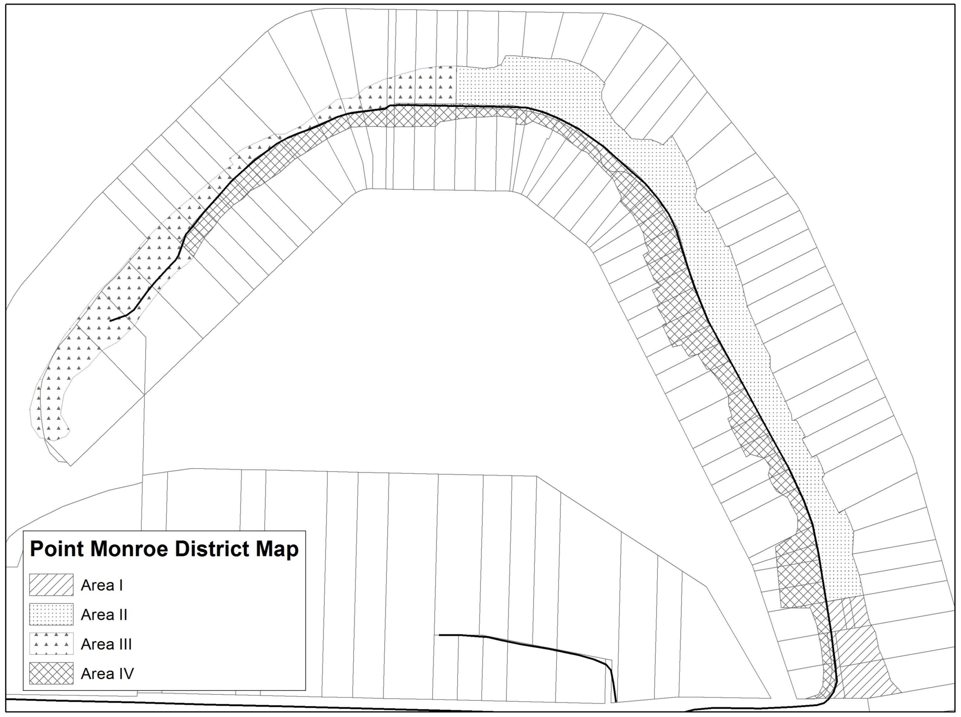
Figure 16.12.050-1
12. Regulations – Subdivisions. Land subdivision shall be designed to assure future development will not require shoreline stabilization for the next 100 years from date of building permit approval as demonstrated by a geotechnical report.
13. Submittal Requirements for Shoreline Stabilization Project Applications.
a. In addition to the general submittal requirements for all applications specified in BIMC 2.16.020.J, the following shall be submitted to the city. Applications for repair of existing stabilization will be required to submit only the first six items. The administrator may waive some or all of the following based on specific project requirements:
i. Purpose of the project including a calculation that demonstrates the amount proposed to be repaired and past amounts repaired and a summary of replacement and/or repair materials proposed; and
ii. Plan and cross section views of the existing and proposed shoreline configuration, showing accurate existing and proposed topography and the OHWM, including an indication of the amount of area proposed to be repaired; and
iii. Documentation of preconstruction shoreline characteristics; and
iv. Description of physical, geological and/or soil characteristics of the site including existing and proposed slope profiles; and
v. A description of any waste and debris disposal sites for materials generated during construction; and
vi. For repair of shoreline stabilization, the design recommendations for minimizing impacts and ensuring the new construction, replaced or repaired stabilization measure is designed, located, sized and constructed to assure no net loss of ecological functions and processes; and
vii. Examination and implementation of alternatives in the order of preference as described in subsection B.8 of this section, Regulations – New or Replacement Shoreline Stabilization, including a description of cost, mitigation cost, maintenance needs and success in protecting the primary structure; and
viii. Existing shoreline stabilization within the reach of the proposed project; and
ix. Any outreach efforts to coordinate with property owners within the shoreline reach to address an ecosystem-wide restoration plan; and
x. A description of any waste and debris disposal sites for materials generated during construction; and
xi. A discussion of the cause of shoreline erosion including assessment of ecosystem-wide processes occurring both waterward and landward of the OHWM and an analysis of on-site and/or adjacent upland drainage; and
xii. Impact analysis and mitigation report as specified by BIMC 16.12.030.B.2, Environmental Impacts; and
xiii. Geotechnical report including the estimated rate of erosion and imminent danger within the time threshold as provided in this subsection B and the following:
(A) Proof of a geotechnical design of the structural stabilization; and
(B) Washington State licensed civil engineer with a specialty in coastal engineering or a qualified Washington State licensed geologist with a specialty in coastal geology and a qualified marine habitat biologist shall evaluate the cumulative effects of stabilization methods within a drift cell; and
(C) Maintenance, monitoring and planting plan as required by BIMC 16.12.030.B.2, Environmental Impacts.
C. Overwater Structures.
1. Applicability. Uses which may employ a pier or dock are subject to the provisions herein as well as to the provisions contained in BIMC 16.12.040, Specific shoreline use and development regulations. Single-use, community, or joint-use docks which provide moorage for six or more vessels also must comply with the provisions of BIMC 16.12.040.C, Boating Facilities.
Pursuant to RCW 90.58.030(3)(e)(vii) or its successor and WAC 173-27-040(2)(h) or its successor, certain activities are exempt from obtaining a shoreline substantial development permit (SSDP). For the benefit of the lot owner, surrounding properties, and water body users, the city will review all proposals for piers and docks to determine whether:
a. The proposal is or is not exempt from the requirements for a shoreline permit;
b. The proposal is suitably located and designed and that all potential impacts have been recognized and mitigated; and
c. The proposal is consistent with the intent, policies, and regulations of the Act (RCW 90.58.140(1) or its successor) and this program.
Activities that are exempt from a shoreline substantial development permit must still meet the provisions of the master program. A pier, dock or float associated with a single-family residence is considered a water-dependent use; provided, that it is designed and intended as a facility to tie up watercraft. Overwater structure activities will be reviewed under the no net loss provisions of BIMC 16.12.030.B.2, Environmental Impacts, and BIMC 16.12.030, General (island-wide) regulations; BIMC 16.12.030.B.1, Shorelines of Statewide Significance; and may also be reviewed under BIMC 16.12.030.B.5, Critical Areas; BIMC 16.12.030.B.6, Water Quality and Stormwater Management. Other portions of this program may also apply.
2. Regulations – Prohibited.
a. Overwater structures in the priority aquatic designations and adjacent to the natural designation except:
i. New individual, community or joint-use residential docks or piers are permitted in the priority aquatic B designation, only in areas where salt marsh vegetation, such as pickleweed (Salicornia sp.), does not exist.
ii. Two mooring buoys per parcel are allowed for public access when upland property is owned by a public entity.
b. Overwater structures at locations where critical physical limitations exist, such as shallow sloping tidelands with gradients of three percent or less; or areas mapped for high levels of accretion; or geological hazardous areas located outside of harbors and/or feeder bluffs, except when specifically allowed in BIMC 16.12.030.C.4, Public Access – Visual and Physical, or BIMC 16.12.040.C, Boating Facilities.
c. Development of new docks and piers within all shoreline designations within Blakely Harbor between Restoration Point and the most eastern point along the north shore of Blakely Harbor (sometimes referred to as “Pigott Point” or “Jasmine Point”), except as provided in this section.
d. New docks and piers within Murden Cove as shown on the shoreline designation map.
e. New boat houses and/or new covered moorage on either existing or new piers or docks.
f. Hydraulic water jets cannot be used to remove piling.
g. Use of arsenate compounds or creosote-treated members.
h. Overwater field applications of paint, preservative treatment, or other chemical compounds, except in accordance with best management practices set forth in BIMC 16.12.040.C, Boating Facilities, or when allowed by a current national pollution discharge elimination system (NPDES) permit from the Department of Ecology.
i. Bulk storage for gasoline, oil and other petroleum products for any use or purpose on piers and docks. “Bulk storage” means nonportable storage in fixed tanks.
3. Regulations – General.
a. Except for the provisions contained in this chapter, new piers and docks shall be a permitted use in the urban, shoreline residential, and aquatic designations, and shall be a conditional use in the shoreline residential conservancy and island conservancy designations.
b. Mooring buoys are a preferred use, over docks, where feasible.
c. Piers and docks shall be located and designed to minimize interference with the use of navigable waters and may be limited in length or prohibited, where necessary, to protect navigation, public use, or habitat values including critical saltwater habitat.
d. If a bulkhead-like base is proposed for a fixed pier or dock the base shall be built landward of the ordinary high water mark or protective berm and is considered shoreline stabilization and must meet provisions of subsection B of this section, Shoreline Stabilization.
e. Structures on piers and docks shall be strictly limited in size to avoid impacting shoreline views.
f. Piers and docks shall require a building permit and shall meet standards set by the building official, except public ferry terminals as part of the state highway system.
g. Lighting shall:
i. Satisfy the provisions of BIMC 18.15.040;
ii. Be the minimum necessary, or as required by the Coast Guard, to locate the dock at night; and
iii. Should minimize glare.
h. Mitigation requirements of BIMC 16.12.030.B.2, Environmental Impacts, may be met through mitigation standards for the United States Army Corps of Engineers (USACE) permit process.
i. New docks and piers shall be allowed only for water-dependent uses or public access. As used here, a dock associated with a single-family residence is a water-dependent use and may be permitted; provided, that it is designed and intended as a facility for access to watercraft and otherwise complies with the provisions of the Act and this program.
j. Piers and dock construction shall adhere to fish window provisions found in Chapter 220-110 WAC by the Washington Department of Fish and Wildlife.
4. Regulations – Location, Design and Construction Standards – Pier, Dock, Float.
a. A single-use dock consists of pier, ramp, float, and one boat lift. An additional boat lift may be added per dwelling unit for joint-use docks.
b. When plastics or other nonbiodegradable materials are used in float, pier, or dock construction, precautions shall be taken to ensure their containment.
c. Overhead wiring or plumbing is not permitted on overwater structures.
5. Regulations – Specific.
a. Piling Regulations.
i. Principle: Piles are physical barriers to fish migration and have the potential to leach contaminants into aquatic and nearshore environments. Piling installed close together can cause floating debris to accumulate, which can lead to increased shading and predator protection. The fewest number of pilings necessary should be installed and spacing between piling should be maximized. Projects must be designed to minimize abrasion between the pier, ramp and float caused by tidal fluctuations because this can result in the deposition of contaminants into the water and over time will cause a loss of structural integrity requiring additional maintenance by the applicant.
(A) Replacement or new piling shall be steel, concrete, plastic or untreated or approved treated wood, if approved by USACE. Any piling subject to abrasion (and subsequent deposition of material into the water) must incorporate design features to minimize contact between all of the different components of overwater structures during all tidal elevations.
(B) New piling associated with a new pier, except large water-dependent ferry terminals, must be spaced at least 20 feet apart (lengthwise along the structure) unless the length of structure itself is less than 20 feet. If the structure itself is less than 20 feet in length, piling can only be placed at the ends of the structure. Piles in forage fish spawning areas need to be spaced at least 40 feet apart.
(C) If the project includes the replacement of existing piling, they should be either partially cut with a new piling secured directly on top, fully extracted, or cut two feet below the mudline. If treated piling are fully extracted or cut, the holes or piles must be capped with clean, appropriate material.
(D) A maximum of two moorage pilings may be installed to accommodate the moorage of boats exceeding the length of the floats.
(E) Piles, floats, or other components in direct contact with water shall not be treated or coated with biocides such as paint or pentachlorophenol. In saltwater areas characterized by shellfish populations or in shallow embayments with poor flushing characteristics, untreated wood, used pilings, precast concrete, or other nontoxic alternatives shall be used. In all cases where toxic-treated products are allowed, products, methods of treatment, and installations shall be limited to those that are demonstrated as likely to result in the least possible damage to the environment based on current information.
(F) Piling employed in piers or any other structure shall have a minimum vertical clearance of 18 inches above extreme high water.
b. Pier Regulations.
i. Principle: In the Puget Sound, the intertidal and subtidal substrate supports a complex web of plant and animal species. Juvenile salmon, called “salmonids,” young and adult bull trout, and juvenile rockfish use nearshore marine areas for feeding, rearing, and as migratory corridors. Their predators are generally located in deeper waters that young fish tend to avoid. As they mature they become less dependent on shallow areas and begin preying on forage fish, many of which spawn on the intertidal substrate around eelgrass, kelp beds and macroalgae. Piers create shadows that can impact the viability of marine vegetation that require sunlight to grow. This subsequently adversely impacts the habitat of fish that so many other species (including human beings) rely upon. In addition, large shaded areas provide cover for predators, so for these reasons the amount of shade created by piers must be minimized.
(A) The width of the modified portion of a pier or proposed new pier must not exceed four feet for single use or six feet for joint use. Pier width for marinas or public use docks may exceed these restrictions if they provide mitigation, which may include artificial lighting under the pier during daytime hours.
(B) Functional grating resulting in a total open area of a minimum of 30 percent must be installed on all new or replacement piers that are four to six feet wide. For example, this can be achieved by installing grating with 60 percent open area on at least 50 percent of the pier or by grating a larger percentage of the pier with grating with openings of less than 60 percent. Site conditions may require pier to be 100 percent or fully grated.
(C) For all sections of the pier that span upper intertidal areas with obligate vegetation, that pier section shall be fully grated with grating having 60 percent open area.
c. Float Regulations.
i. Principle: Sharp shadows cast by floats and float tubs have been shown to discourage salmonids and other young fish from passing underneath, forcing them into deeper water where their chance of being preyed upon is increased and water temperature and conditions are different. In the case of rockfish, they give birth to live larval young that spend several months being passively dispersed by tidal fluctuations; as they mature they move out to deeper water but initially are at a high risk of predation. Manmade shade creates artificial pockets of opportunity for the predators of young fish and unlike the shade from overhanging vegetation the negative impacts outweigh the benefits. Finally, to prevent damage to the substrate, benthic invertebrate communities and vegetation, floats should not rest on substrate low tide and should be fully encased to prevent the deterioration and dispersion of flotation materials.
(A) For a single-use structure, the float width must not exceed eight feet and the float length must not exceed 30 feet. Functional grating must be installed on at least 50 percent of the surface area of the float.
(B) For a joint-use structure, the float width must not exceed eight feet and the float length must not exceed 60 feet. Functional grating must be installed on at least 50 percent of the surface area of the float.
(C) To the maximum extent practicable, floats must be installed with the length in the north-south direction.
(D) If the float is removed seasonally, the applicant needs to indicate this in their application along with the proposed storage location. Floats should be stored above mean high/high water/ordinary high water line at a city approved location. City authorization may be required if the float will be stored within city jurisdiction (even within a marina).
(E) Flotation for the float shall be fully enclosed and contained in a shell (e.g., polystyrene tubs not shrink wrapped or sprayed coatings) that prevents breakup or loss of the flotation material into the water and is not readily subject to damage by ultraviolet radiation and/or abrasion caused by rubbing against piling and/or waterborne debris.
(F) Flotation components shall be installed under the solid portions of the float, not under the grating.
(G) If the float is positioned perpendicular to the ramp, a small float may be installed to accommodate the movement of the ramp due to tidal fluctuations. The dimensions of the small float cannot exceed six feet in width and 10 feet in length.
d. Float Stop Regulations.
i. Principle: Floats need to be above the substrate; the preferred and least impacting option is to suspend the float above the substrate by installing float stops on pilings designed to anchor floats, installing a few stub pilings, or in certain situations it could be appropriate to install float feet. In all cases, the stops must be able to fully support the entire float during all tidal elevations.
(A) Floats need to be suspended a minimum of one foot above the tidal substrate at all tide levels.
(B) To suspend the float above the substrate, the preferred and least impacting option is to suspend the float above the substrate by installing float stops (stoppers) on piling anchoring new floats. The stops must be able to fully support the entire float during all tidal elevations.
(C) If float stops attached to pilings are not feasible, then up to four 10-inch-diameter stub pilings can be installed instead, except an additional two may be installed for joint-use floats.
(D) Float feet attached to the float may be considered an option only under these circumstances:
(1) In coarse substrate, D252 of 25 mm or larger for a grain size sample taken from the upper one foot of substrate;
(2) For elevations of minus three MHHW and lower at D25 of four mm or larger for a grain size sample taken from the upper one foot of the substrate (intent is to exclude muck);
(3) For repair or replacement of existing float feet if the following two conditions are met: (a) substrate looks like it contains mostly gravel (no analysis needed, picture sufficient), and if (b) proposed replacement or repair includes other improvements of the environmental baseline like the removal of creosote-treated piling and increased amounts of grating.
(E) Floats can be held in place with lines anchored with a helical screw or “duckbill” anchor, piling with stoppers and/or float support/stub pilings.
(1) For a single-use float, a maximum of four pilings (not including stub piling), helical screws, or “duckbill” anchors can be installed to hold the float in place.
(2) For a joint-use float, a maximum of eight pilings, helical screws or “duckbill” anchors can be installed to hold the float in place.
(3) If anchors and anchor lines need to be utilized, the anchor lines shall not rest on the substrate at any time.
(4) In rocky substrates where a helical screw or “duckbill” anchor cannot be used, if the applicant submits a rationale why these types of anchors cannot be used and the administrator concurs with this rationale, an approved anchor of another type (i.e., concrete block) may be permitted.
e. Regulations – Residential Community and Joint-Use Piers and Docks.
i. Any hotel, motel, and/or multifamily residential development proposing to provide moorage facilities shall be required to construct a single, joint-use moorage facility. The administrator may authorize more than one joint-use moorage facility if a single facility would be inappropriate or undesirable, given the specific conditions of the site. Facilities for moorage of six or more vessels are considered a marina and must meet regulations in BIMC 16.12.040.C, Boating Facilities.
ii. Proposals for community or joint-use piers and docks shall demonstrate, by proof of recording of a covenant binding current and future parties, that adequate maintenance of the structure and the associated upland area will be provided by identified responsible parties. The proposed covenant shall be filed as part of the permit application and recorded after final approval. An access easement to joint-use docks shall be granted for all lots or dwelling units.
iii. In Blakely Harbor:
(A) A total of two community docks shall be a conditional use within the upland and aquatic designations with no more than one along each the north and south shores, respectively; provided, that all residents along each shore shall have a nonextinguishable option to access the community dock located along their respective shore;
(B) One daytime use public dock and/or pier for the mooring of dinghies and loading or unloading of vessels shall be a conditional use within the upland and aquatic designations; and
(C) Such community and public docks shall comply with this master program and other applicable laws; shall be the minimum size necessary; and shall be sited and designed to mitigate adverse impacts to navigation, views, scenic character, and natural resources as much as possible. Such community and public docks shall also be reasonably passable to swimmers, beach walkers, and human-powered water craft.
f. Regulations – Commercial/Industrial Facilities Piers and Docks. These standards apply to piers and docks intended for any commercial or industrial use other than commercial moorage of boats in marinas. (See also BIMC 16.12.040.C, Boating Facilities; BIMC 16.12.040.D, Commercial Development; and BIMC 16.12.040.F, Industrial Development.)
i. Substantial development permits for docks or piers serving single commercial or industrial enterprises shall not be granted until the access needs of adjacent commercial and/or industrial enterprises have been determined.
ii. Commercial or industrial piers or docks shall not extend offshore farther than the most shoreward of the following:
(A) The average length of the piers on the two adjoining properties;
(B) In Eagle Harbor, the construction limit line;
(C) Elsewhere, the distance necessary to obtain a depth of four feet of water as measured at extreme low tide at the landward limit of the moorage slip; or
(D) The line of navigation; and
(E) In no case shall piers and their associated ramps and floats extend greater than 15 percent of the perpendicular shore-to-shore distance across a water body, except where a navigational study has been submitted for city review and approval.
iii. Facilities and procedures for receiving, storing, dispensing, and disposing of oil and other toxic products shall be designed to ensure that such oil and other toxic products are not introduced into the water body.
iv. Spill clean-up facilities shall be available for prompt response and application at all piers and docks involved in oil and hazardous products transfer.
g. Regulations – Residential (Joint, Community and Individual) Piers and Docks.
i. New subdivisions and short subdivisions with shoreline frontage shall be required to provide community docks rather than individual, private docks.
ii. Size.
(A) Maximum width of a pier or dock shall be the minimum necessary to accomplish moorage for the intended boating use (see subsection C.5.b of this section, Pier Regulations, for additional restrictions); and
(B) The length shall not extend beyond the average length of adjacent docks, within 500 feet of the proposed location or the distance necessary to obtain a depth of nine feet of water as measured at mean lower-low water (MLLW) at the landward limit of the moorage slip, whichever is closer to shore. A dock shall not extend beyond the adjoining property dock or the line of navigation and in no case shall piers and their associated ramps and floats extend greater than 15 percent of the perpendicular shore-to-shore distance across a water body, except where a navigational study has been submitted for city review and approval; and
(C) In Eagle Harbor, a pier or dock shall not extend beyond the construction limit line (Figure 16.12.050-2); and
(D) A pier or dock shall not extend beyond the harbor structure limit line shown in Figure 16.12.050-3.
iii. Side-Yard Setbacks. Docks, piers and floats shall be set back a minimum of 10 feet from side property lines, except that community piers, docks, and floats may be located adjacent to or upon a side property line when mutually agreed to by covenant with the owners of the adjacent property. A copy of the covenant must be recorded with the county auditor and filed with the application of the permit.
iv. Community docks and piers shall include no more than one moorage space per dwelling unit or lot.
h. Regulations – General Mooring Buoys and Recreational Floats.
i. Mooring buoys and recreational swim float use shall be permitted in the aquatic environment offshore from island conservancy, shoreline residential, shoreline residential conservancy, and urban designations.
ii. Mooring buoys for commercial use shall be permitted only as conditional uses offshore from the urban designation. Mooring buoys for public open water moorage and anchorage areas shall be permitted in the aquatic designation offshore of all upland designations.
iii. No more than one structure may be installed for each ownership. However, properties that contain at least 200 linear feet as measured along the shoreline may be permitted more installations on a case-by-case basis as determined by the city and the State Department of Natural Resources (WAC 332-30-148(3) or its successor). Properties where the waterfront lot is owned in community may be permitted additional mooring buoys with the total not more than one per 100 linear feet of shoreline ownership.
iv. Mooring buoys for commercial vessels adjacent to commercial or industrial zones are a shoreline conditional use. One buoy is allowed per ownership.
v. A contractor doing waterfront work involving floating equipment may have one temporary mooring buoy provided it is the responsibility of the contractor to ensure that all necessary permits are obtained from all agencies with jurisdiction.
i. Regulations – Location, Design and Construction Standards – Mooring Buoys and Recreational Floats.
i. In order to protect shellfish beds, new mooring buoys shall not be permitted where density will exceed one buoy per 100 linear feet.
ii. Buoys shall not interfere with navigation, shall be visible in daylight 100 yards away, and shall have reflectors for night visibility.
iii. If a buoy is located offshore of the extreme low tide line, the owner shall obtain a lease for the bed of navigable waters from the Department of Natural Resources (RCW 79.105.430 or its successor).
iv. Buoys shall lie between the waterfront property side lot lines extended beyond the shoreline, except those on state waters. Buoys shall not swing across the extended side lot lines. Where the configuration of the waterfront lot precludes these requirements, authorization from the affected adjacent waterfront property owners must be obtained. This provision shall not apply to buoys for public open water moorage and anchorage areas.
v. Mooring buoys shall be installed at least 60 feet from other permitted piers, docks, or floats.
vi. Buoys shall be located:
(A) At a minimum depth of nine feet MLLW with a standard single mid-line float; the minimum depth may be reduced with an alternate system approved by the administrator;
(B) Landward of the construction limit line in Eagle Harbor (Figure 16.12.050-2);
(C) Landward of the harbor structure limit line shown in Figure 16.12.050-3;
(D) Elsewhere not more than 200 feet beyond extreme low tide, the -18 feet MLLW depth contour, or the line of navigation, whichever is appropriate. The placement of rafts and buoys beyond the -18 feet MLLW contour or 200 feet will be evaluated on a case-by-case basis (WAC 332-30-148(2) or its successor); and
(E) Buoys for public open water moorage and anchorage areas shall be allowed waterward of the construction limit line in Eagle Harbor.
vii. Recreational floats shall be located as close to shore as possible and no farther waterward than the following limits:
(A) In Eagle Harbor, the construction limit line; or
(B) Elsewhere, the distance necessary to obtain a depth of four feet of water as measured at extreme low tide at the landward end of the float, or the line of navigation, whichever is closer to shore.
viii. Recreational floats must be built so that the deck surface is one foot above the water’s surface and shall have reflectors for night visibility.
ix. Recreational floats shall not exceed eight feet by eight feet.
x. All recreational floats shall include stops, or devices or systems approved by the administrator, which serve to keep the floats off the bottom of tidelands at low tide. See subsection C.5.d of this section, Float Stop Regulations.
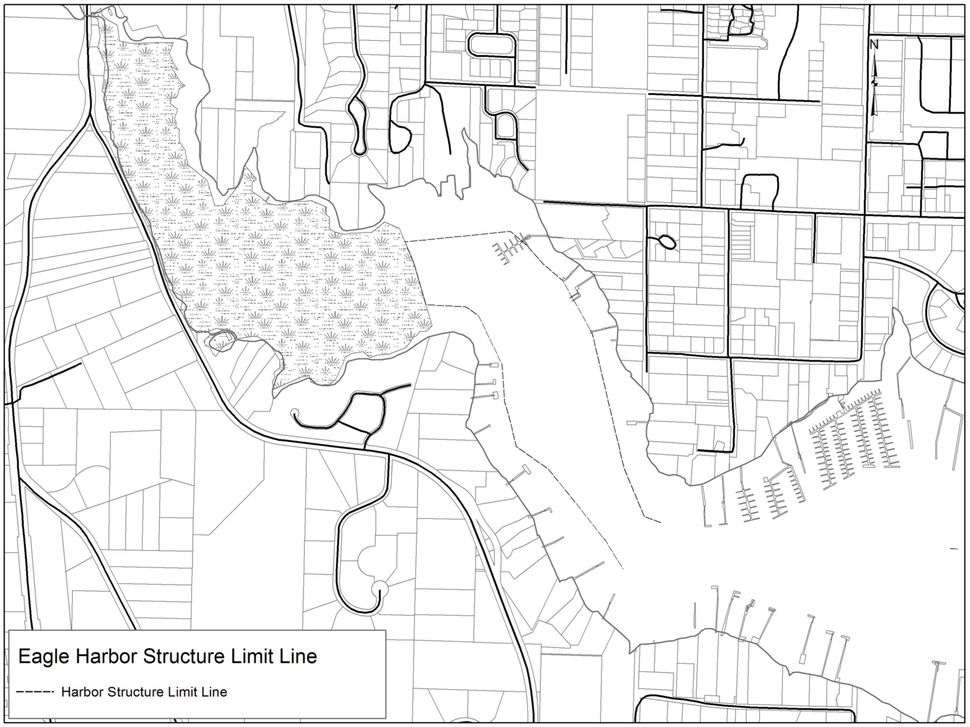
Figure 16.12.050-2
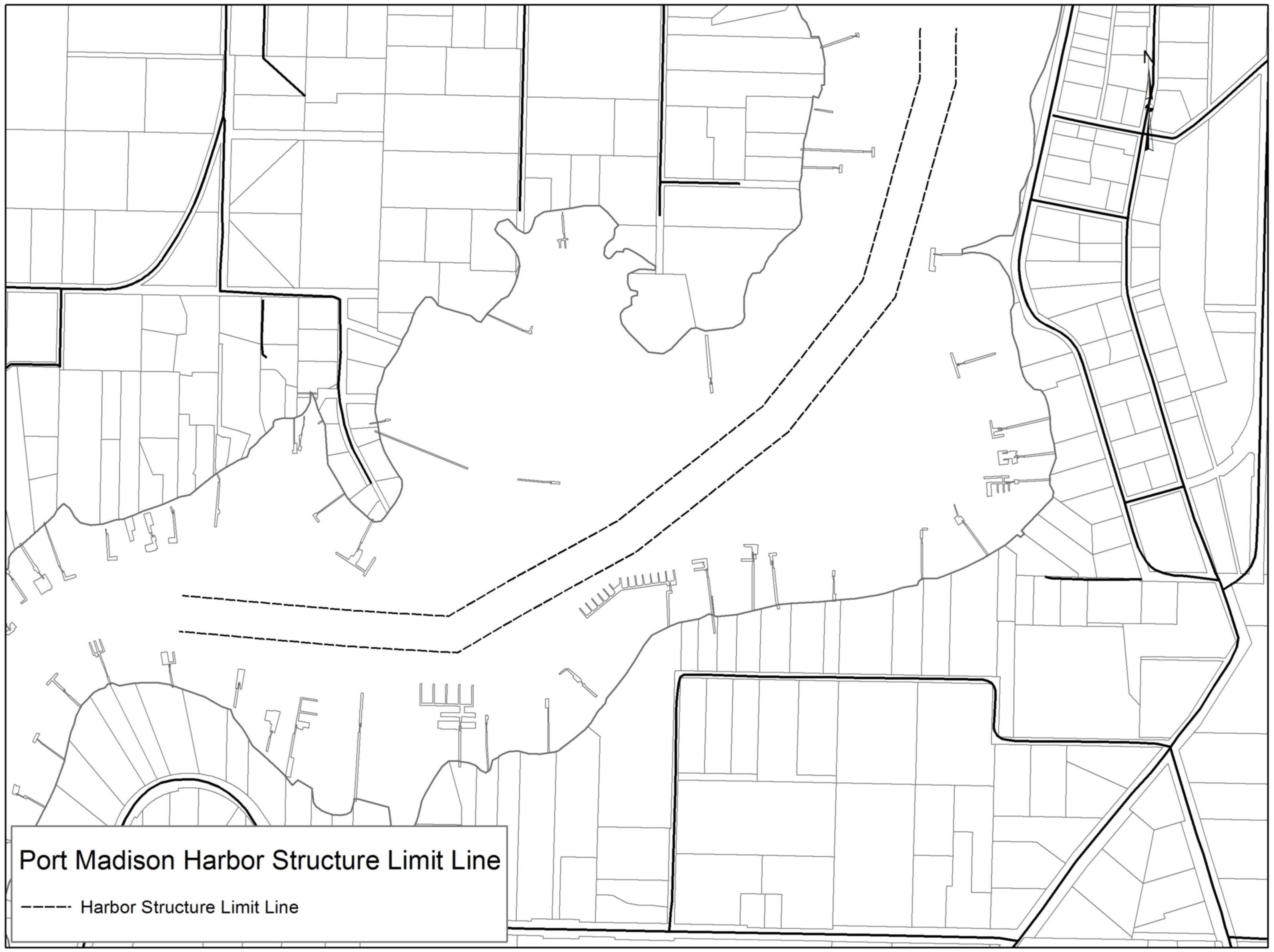
Figure 16.12.050-3
D. Dredging and Dredge Material Disposal.
1. Applicability. Dredging is the removal of material from the bottom of a water body. The purposes of dredging might include: deepening a navigational channel, berth, or basin; streambed maintenance; use of dredged material for fill or habitat enhancement (effective reuse); and removal of contaminated sediments. Dredged material disposal on land is also subject to the fill policies and regulations of this program. Pursuant to WAC 173-27-040 or its successor, certain activities, such as those associated with normal maintenance and repair, are exempt from the requirements for a SSDP, but may still require a letter of exemption, shoreline conditional use permit or variance.
All actions are required to comply with the Shoreline Management Act and all provisions of the master program. Department of Ecology and U.S. Army Corps of Engineers notifications of dredging proposals will be reviewed by the city to determine whether the activity is exempt from the requirements for a substantial development permit and to ensure compliance with regulations of the Act and the master program.
Dredging activities will be reviewed under the no net loss provisions of BIMC 16.12.030.B.2, Environmental Impacts, and may also be reviewed under BIMC 16.12.030, General (island-wide) regulations; BIMC 16.12.030.B.3, Vegetation Management; BIMC 16.12.030.B.4, Land Modification; BIMC 16.12.030.B.5, Critical Areas; BIMC 16.12.030.B.6, Water Quality and Stormwater Management; and subsection E of this section, Fill. Other portions of this program may also apply.
2. Regulations – Prohibited.
a. New dredging activity is prohibited in the following:
i. In environmentally sensitive habitats (e.g., stream mouth estuaries, wetlands) except by shoreline conditional use permit.
ii. Along net-positive drift cells and/or where geohydraulic processes are active and accretion shoreforms would be damaged, altered, or irretrievably lost.
iii. In shoreline areas with bottom materials that are prone to significant sloughing and refilling due to currents or tidal activity, thus resulting in the need for continual maintenance dredging.
iv. In habitats identified as critical to the life cycle of officially designated or protected fish, shellfish, or wildlife.
v. In areas where concentrations of environmental pollutants or toxic chemicals are present in the bottom of sediments and would be released in dredging operations, except as part of a permitted environmental enhancement or remediation program.
vi. For the primary purpose of obtaining material for landfill, upland construction, or beach nourishment is prohibited.
vii. On or in archaeological sites.
b. Dredging shall be prohibited in the priority aquatic Category A designation.
3. Regulations – General.
a. Dredging is a conditional use in the aquatic designation if permitted in the upland designation and shall be for the restoration, enhancement, or maintenance of natural resources and navigational channels or for publicly owned ferry terminals. Dredging shall be permitted as a conditional use in the priority aquatic Category B designation as part of an approved restoration proposal.
b. Proposals for dredging and dredge spoil disposal, when permitted, shall:
i. Be kept to the minimum necessary to accommodate the proposed use;
ii. Comply with applicable federal, state, and other local regulations;
iii. Employ appropriate measures to protect public safety and prevent adverse impacts on other approved shoreline uses;
iv. Take appropriate measures to ensure the activity will not interfere with fishing or shellfish harvesting;
v. Employ appropriate best management practices to protect marine, estuarine, freshwater and terrestrial species and critical saltwater habitats and to minimize adverse impacts such as turbidity, release of nutrients, heavy metals, sulfides, organic materials, or toxic substances, depletion of oxygen, disruption of food chains, loss of benthic productivity, and disturbance of fish runs and important localized biological communities;
vi. Be scheduled so as to not materially interfere with the migratory movements of anadromous fish;
vii. Not adversely alter natural drainage and circulation patterns, currents, and tidal flows, or significantly reduce flood water capacities;
viii. Utilize techniques that cause minimum dispersal and broadcast of bottom material; hydraulic dredging shall be used wherever feasible in preference to agitation dredging;
ix. Not interfere with geo-hydraulic processes;
x. Be found, through analysis by a qualified professional, to be minimally or nonpolluting; and
xi. Revegetate land disposal sites with native vegetation species and other approved plants shall be required according to BIMC 16.12.030.B.2.c, Regulations – Revegetation Standards.
4. Regulations – Specific Dredging.
a. Dredging, when allowed in subsection D.3 of this section, Regulations – General, shall support the following uses and developments:
i. Approved harbors, marinas, ports, and water-dependent industries;
ii. Development or maintenance of essential public infrastructure and facilities;
iii. Environmental clean-up activities required by the Model Toxics Control Act (MTCA) or Comprehensive Environmental Response, Compensation, and Liability Act (CERCLA);
iv. Underground utility installation requiring trenches when boring, directional drilling, and other installation methods are not feasible;
v. Maintenance dredging for the purpose of restoring a lawfully established industrial or commercial water-dependent development;
vi. Maintaining, establishing, expanding, relocating or reconfiguring navigation channels and basins where necessary to assure the safety and efficiency of existing navigational uses;
vii. Ecological restoration and enhancement projects benefiting water quality and/or fish and wildlife habitat; or
viii. Public access and public water-oriented recreational developments/uses, including construction of public piers and docks.
b. New development shall be sited and designed to avoid or, if that is not possible, to minimize the need for new and maintenance dredging.
c. Maintenance dredge options shall occur in the same location, depth, and width as previously permitted.
5. Regulations – Dredge Material Disposal.
a. All unconfined, open water dredge disposal activities shall comply with the Puget Sound Dredged Disposal Analysis (PSDDA) criteria and guidelines and other applicable local, state and federal regulations.
b. When consistent with this program, disposal of dredged materials in water areas other than PSDDA sites may only be allowed for the following reasons:
i. To restore or enhance habitat;
ii. To reestablish substrates for fish and shellfish resources;
iii. To nourish beaches that are starved for sediment; or
iv. To remediate contaminated sediments.
E. Fill.
1. Applicability. Fill is the placement of soil, sand, rock, gravel, existing sediment, or other material (excluding solid waste) along the shoreline below the OHWM, or on wetland or upland of the OHWM. Fill activities shall only be allowed as part of an approved shoreline use and/or development activity and shall be subject to the requirements of the principal use/development. Speculative fill activity is prohibited. Any fill activity conducted within shoreline jurisdiction must comply with the following policies and regulations. Beach nourishment as defined in the shoreline master program shall not be considered fill. Excavation waterward of the ordinary high water mark is regulated under subsection D of this section, Dredging and Dredge Material Disposal. Fill activities will be reviewed under the no net loss provisions of BIMC 16.12.030.B.2, Environmental Impacts, and may also be reviewed under BIMC 16.12.030.B.4, Land Modification; BIMC 16.12.030.B.5, Critical Areas; and BIMC 16.12.030.B.6, Water Quality and Stormwater Management. Other portions of this program may also apply.
2. Prohibited.
a. Speculative fill activity.
b. Fill that will result in significant adverse impacts that cannot be avoided or mitigated.
c. Fill in the priority aquatic designations.
3. Regulations – General.
a. Fill is allowed as a conditional use as follows:
i. In the urban, shoreline residential, and shoreline residential conservancy designations.
ii. In the island conservancy and natural designations only for the restoration, enhancement, or maintenance of natural resources. See BIMC 16.12.030.B.8, Shoreline Restoration and Enhancement, for additional requirements and permit requirements.
iii. In the aquatic designation, for commercial or industrial water-dependent or essential public facilities, or as part of a permitted environmental enhancement or remediation project.
b. When allowed in subsection E.3.a of this section, fill waterward of the OHWM shall be necessary for:
i. Approved marinas, ports, and other water-dependent industries where upland alternatives or structural solutions including pile or pier supports are infeasible.
ii. Development or maintenance of essential public infrastructure and facilities.
iii. Environmental clean-up activities required by MTCA and CERCLA.
iv. Maintenance of a lawfully established use or development.
v. Ecological restoration and enhancement projects benefiting water quality and/or fish and wildlife habitat.
vi. Public access and public water-oriented recreation projects benefiting substantial numbers of people.
c. Pile or pier supports shall be utilized whenever feasible in preference to fills. Fills for approved road development in floodways or wetlands shall be permitted only if the pile or pier supports are demonstrated to be infeasible.
4. Regulations – Location, Design and Construction.
a. When allowed in subsection E.3 of this section, filling and/or excavation shall be located, designed, and carried out in a manner that:
i. Minimizes adverse impacts on the shoreline environment including significant damage to water quality, critical saltwater habitat;
ii. Blends in physically and visually with natural topography, so as not to interfere with appropriate use, impede public access, or degrade the aesthetic qualities of the shoreline;
iii. Does not require shoreline stabilization to protect materials placed unless it is part of an approved shoreline restoration project and shoreline stabilization measures are needed to keep the material in place; and
iv. Does not adversely alter natural drainage and circulation patterns, currents, river and tidal flows, or significantly reduce flood water capacities.
b. Where fills are permitted, the fill shall be the minimum necessary to accommodate the proposed use. Fills shall be located, designed, and constructed to protect shoreline ecological functions and ecosystem-wide processes.
c. Where fills reduce public access, compensatory public access shall be provided as part of the development project.
d. Fill proposals shall be designed, constructed, and maintained to prevent, minimize, and control all material movement, erosion, and sedimentation from the affected area. Perimeters of permitted fill projects shall be designed and constructed with silt curtains, vegetation, retaining walls, or other mechanisms, and appropriately sloped to prevent erosion and sedimentation both during initial landfill activities and afterwards. Such containment practices shall occur during the first growing season following completion of the landfill.
e. Fill materials shall be sand, gravel, soil, rock, or similar material. Use of contaminated dredge material is prohibited. (See BIMC 16.12.040.F, Industrial Development, and subsection D of this section, Dredging and Dredge Disposal.)
f. The timing of any fill construction shall be regulated to minimize damage to water quality and aquatic life within the time restraints recommended by the Washington State Department of Fish and Wildlife. (Ord. 2020-17 § 3 (Exh. A), 2020; Ord. 2014-04 § 3 (Exh. 1 § 6), 2014)
16.12.060 Critical areas.
Repealed by Ord. 2020-17. (Ord. 2014-04 § 3 (Exh. 1 Appx. B), 2014)
16.12.070 Violations, enforcement, and penalties.
A. General. The administrator and the Department of Ecology are authorized to adopt such rules as are necessary and appropriate to carry out the provisions of the Shoreline Management Act (RCW 90.58.200) and Chapter 173-27 WAC, Part II. The Act calls for a cooperative program between local government and the state. It provides for a variety of means of enforcement, including civil and criminal penalties, orders to cease and desist, orders to take corrective action, and permit rescission. The following should be used in addition to other mechanisms available to the city in accordance with WAC 173-27-240 through 173-27-300 or their successors. The city and/or the Department of Ecology shall have the authority to serve upon a person a cease and desist order if an activity being undertaken on shorelines of the state is in violation of Chapter 90.58 RCW or this master program, in accordance with WAC 173-27-270 or its successor.
When joint-enforcement actions between the state and the city are undertaken, the provisions in RCW 90.58.210 through 90.58.230 and WAC 173-27-240 through 173-27-300 shall apply.
B. Regulations.
1. Site Investigations. The administrator is authorized to make site inspections and take such actions as are necessary to enforce this master program in accordance with Chapter 1.16 BIMC, Right of Entry for Inspection, and Chapter 1.26 BIMC, Code Enforcement.
2. Violations – General. It is unlawful for any person to initiate or maintain, or cause to be initiated or maintained, the use, construction, placement, removal, alteration, or demolition of any structure, land, vegetation or property within the city contrary to the provisions of this master program.
3. Violations – Specific. It is unlawful for any person to:
a. Initiate or maintain, or cause to be initiated or maintained, the use, construction, placement, removal, alteration, or demolition of any structure, land, vegetation or property within the city without first obtaining permits or authorizations required by this master program, or in a manner that violates the terms or conditions of such permits or authorizations.
b. Misrepresent any material fact in any application, plans or other information submitted to obtain permits or authorizations under this master program.
c. Remove or deface any sign, notice, complaint, or order required by or posted in accordance with this master program.
4. Stop Work Order. The city shall have the authority to issue a stop work order to cease all development work, and order restoration, rehabilitation, or replacement measures, including applicable sureties, at the owner’s or other responsible party’s expense to compensate for the use, construction, placement, removal, alteration, or demolition of any structure, land, vegetation or property within the city contrary to the provisions of this master program.
5. After the Fact Permit Fee. After the fact application fees shall be triple the amount established by city council resolution.
6. Violation Mitigation/Restoration Plan. Any mitigation/restoration plan (plan) required for a disturbance not authorized by this shoreline management program or approved by the city shall meet the provisions in BIMC 16.12.030.B.2, Environmental Impacts; BIMC 16.12.030.B.5, Critical Areas; and BIMC 16.12.050, Shoreline modification regulations, and provide an analysis of lost functions over the period of violation.
All development work shall remain stopped until a plan is approved by the administrator. The plan must be prepared at the expense of the violator, and submitted by the owner or other responsible party for approval by the administrator. Such a plan shall be prepared by a qualified professional using the best available science. The administrator may, at the violator’s expense, seek expert advice, including an independent third-party review, in determining the adequacy of the plan. Inadequate plans shall be returned to the applicant or violator for revision and resubmittal.
Any person, party, firm, corporation, or other legal entity that willfully refuses to complete a required restoration plan pursuant to this section shall be guilty of a misdemeanor and provide shoreline restoration, in accordance with provisions of this program, at a rate of 200 percent (ratio of two to one) of the impacted area.
7. Civil Infraction. Except as provided in subsection B.8 of this section, Misdemeanor, conduct made unlawful by the city under this master program shall constitute a civil infraction and is subject to enforcement and fines as provided in BIMC 1.26.035. A civil infraction under this section shall be processed in the manner set forth in Chapter 1.26 BIMC, Code Enforcement, and in compliance with WAC 173-27-280.
8. Misdemeanor. Any person who again violates this master program within 12 months after having been found by the Bainbridge Island municipal court to be in violation of this program commits a misdemeanor and any person who is convicted of that violation shall be punished as provided in BIMC 1.24.010.A.
9. Civil Penalty. In addition to any civil infraction fine, criminal penalty, and/or other available sanction or remedial procedure, any person who shall fail to conform to the terms of a permit or exemption issued under this shoreline master program or who shall undertake development on the shorelines of the state without first obtaining any permit or exemption required under this shoreline master program shall also be subject to a civil penalty in the amount not to exceed $1,000 per day for each violation; each permit violation or each day of continued development without a required permit shall constitute a separate violation (RCW 90.58.210 or successor) from the date set for compliance until the date of compliance. Any such civil penalty shall be collected in accordance with BIMC 1.26.090.
10. General Penalties. In addition to incurring civil liability under subsection B.9 of this section, Civil Penalty, any person, party, firm, corporation, or other legal entity found to have willfully engaged in activities on the shorelines of the state in violation of the provisions of this shoreline master program’s rules or regulations as adopted shall be guilty of a gross misdemeanor and shall be punished by a fine of not less than $25.00 nor more than $1,000 or by imprisonment in the county jail for not more than 90 days, or by both such fine and imprisonment; provided, that the fine for the third and all subsequent violations in any five-year period shall be not less than $500.00 nor more than $10,000 dollars (RCW 90.58.220 or successor).
11. Additional Remedies. In addition to any other remedy provided by this chapter or under the Bainbridge Island Municipal Code, the city may initiate injunction or abatement proceedings or any other appropriate action in courts against any person who violates or fails to comply with any provision of this master program to prevent, enjoin, abate, and/or terminate violations of this master program and/or to restore a condition that existed prior to the violation. In any such proceeding, the person violating and/or failing to comply with any provisions of this master program shall be liable for the costs and reasonable attorneys’ fees incurred by the city in bringing, maintaining and/or prosecuting such action.
12. Conflicts. In the event and to the extent the language of this section conflicts with language of the codes and/or appendices adopted by reference in this master program, the language of this section shall prevail over the language it conflicts with in any said code and/or appendix.
13. Financial Surety Procedure. After reviewing any application or exemption for a shoreline development, the administrator may require the posting of a financial surety to ensure continued compliance with any conditions imposed, including the construction of improvements, the adherence to city standards, and/or maintenance, repair or replacement of such improvements in accordance with BIMC 16.12.030.B.2.e, Regulations – Surety. The financial surety shall be in a form acceptable to the city attorney. In the event a condition occurs warranting the use of financial surety, the administrator may act under such financial surety or may perform the work required at city expense, which expense shall be a lien against the property, enforceable as would be a judgment thereon. (Ord. 2020-17 § 3 (Exh. A), 2020; Ord. 2014-04 § 3 (Exh. 1 § 7), 2014)
16.12.080 Definitions.
“Abutting” means bordering or touching, such as by sharing a common lot line. Lots that are separated by a street or right-of-way are not abutting.
“Accessory development” means any development incidental to and subordinate to a principal use of a shoreline site and located on or adjacent thereto.
“Accessory dwelling unit” means separate living quarters containing kitchen facilities, where the living quarters are contained within or detached from a single-family dwelling on a single lot.
“Accessory structure or building” means a subordinate building or structure that is incidental to the primary or principal building or structure on the same lot, or an abutting lot that meets the requirements in BIMC 18.09.030.I.15.c. Accessory structures include, but are not limited to, solar panels, small wind devices, barns and sheds. Accessory dwelling units are not considered accessory buildings or structures.
“Accessory use” means a use that is customarily incidental and related to the principal use on the same lot. Accessory dwelling units are not considered accessory uses.
“Accretion” means the growth, expansion, build up, or deposit of material associated with a natural fluid flow process.
“Accretion beach” means a place where sediment, usually sand, falls out or accumulates, causing the beach to widen. These sinks are usually, but not always, at the terminal end of a littoral drift cell.
“Accretion shoreform” means the growth of a beach by the addition of material transported by wind and/or water. A shoreline with a relatively stable berm and backshore that has been built up by long-term deposition of sand and gravel transported by wind and/or water from a feeder bluff or other material source. Examples of accretion shoreforms include shoreline features such as barrier beaches, accretion beaches, points, sand spits, hooks, and tombolos.
“Act” means the Shoreline Management Act of 1971, Chapter 90.58 RCW, or its successor (WAC 173-26-020(1), or its successor).
“Activity” means human activity associated with the use of land or resources regulated by this program.
“Adjacent” means that which is near or close; for example, a property located across the road or highway shall be considered as adjacent.
“Adjacent lands” means lands adjacent to the shorelines of the state (outside of shoreline jurisdiction).
“Adjoining” means immediately abutting or separated only by a street right-of-way.
“Administrator” means director of the department of planning and community development, or designee, charged with responsibility for administering the shoreline master program.
“Adverse impact” means an impact that can be measured or is tangible and has a reasonable likelihood of causing moderate or greater harm to ecological functions or processes or other elements of the shoreline environment.
“Agricultural activities” means agricultural uses and practices including, but not limited to: producing, breeding, or increasing agricultural products; rotating and changing agricultural crops; allowing land used for agricultural activities to lie fallow in which it is plowed and tilled but left unseeded; allowing land used for agricultural activities to lie dormant as a result of adverse agricultural market conditions; allowing land used for agricultural activities to lie dormant because the land is enrolled in a local, state, or federal conservation program, or the land is subject to a conservation easement; conducting agricultural operations; maintaining, repairing, and replacing agricultural equipment; maintaining, repairing, and replacing agricultural facilities; provided, that the replacement facility is no closer to the shoreline than the original facility; and maintaining agricultural lands under production or cultivation.
“Agricultural land” means land primarily devoted to agricultural operations.
“Agriculture operations” means any facility or activity for the production, for commercial or family use purposes, of dairy, apiary, livestock, camelids, ratites, vegetable or animal products, and crop products including, but not limited to, ornamental crops. Incidental vegetable gardening, landscaping and keeping common pets are not defined as agriculture. Agriculture operations include upland fish farms which are self-contained, meaning they do not connect with waters of the state such as: natural or channelized stream, tributary, wetland, or marine water body.
“Alteration” means any human induced change in an existing condition of a shoreline, critical area and/or its buffer. Alterations include but are not limited to grading, filling, channelizing, dredging, clearing (vegetation), draining, construction, compaction, excavation, or any other activity that changes the character of the area.
“Alteration, structure” means a change, modification, expansion, or adjustment.
“Anadromous fish” means species such as salmon, which are born in freshwater, spend most of their life cycle in saltwater, and return to freshwater to reproduce.
“Anthropogenic” means landscape alteration relating to or from human development, use, action or activity.
“Applicant” means an individual, partnership, corporation, association, organization, cooperative, public or municipal corporation, or agency, or the state or local governmental unit, however designated (RCW 90.58.030(1)(d) or its successor).
“Appurtenance” means a structure or development which is necessarily connected to the use and enjoyment of a single-family residence and is located landward of the OHWM and/or the perimeter of a wetland. An appurtenance can include a garage, boat house, deck, driveway, utilities, fences, and grading which does not exceed 250 cubic yards (except to construct a conventional drainfield) (WAC 173-27-040(2)(g), or its successor).
“Appurtenance, primary” means a structure or development connected to a single-family residence and considered essential to the principal residential use when protecting the appurtenant structure from danger from active shoreline erosion. An attached garage or one detached garage and a septic drainfield are primary residential appurtenances (WAC 173-26-231(3)(a)(ii), or its successor).
“Aquaculture” means the culture or farming of fish, shellfish, or other aquatic plants and animals. Aquaculture does not include the harvest of wild geoduck associated with the state-managed wildstock geoduck fishery. Upland finfish rearing facilities are included in the definition of agriculture and are not considered aquaculture for the purpose of this SMP. Aquaculture activities include, but are not limited to, the hatching, cultivating, planting, feeding, raising, and harvesting of aquatic plants and animals, and the maintenance and construction of necessary equipment and buildings. Cultivation methods include, but are not limited to, fish pens, shellfish rafts, racks and long lines, seaweed floats and nets, and the planting and harvesting of clams and oysters.
“Aquaculture practices” means any activity directly pertaining to growing, handling, or harvesting of aquaculture produce including, but not limited to, propagation, stocking, feeding, disease treatment, waste disposal, water use, development of habitat and structures. Excluded from this definition are related commercial or industrial uses such as wholesale and retail sales, or final processing and freezing.
“Aquaculture processing” means a commercial or industrial activity that involves preparing fish or shellfish for human use or consumption by packaging, canning, freezing or other means of final wholesale or retail production.
“Aquaculture, shellfish garden” means the cultivation, harvesting, and incidental preparation of shellfish for personal human use and consumption on public and private tidelands.
“Aquatic” means those areas waterward of the ordinary high water mark.
“Aquifer recharge protection area” means a portion of a development site comprised of native or equivalent vegetation in which existing vegetation, topography and supporting soils are free of development, uses or activities detrimental to the aquifer recharge of the total site area.
“Arborist” means an individual engaged in the profession of arboriculture who, through experience, education, and related training, possesses the competence to provide for or supervise the management of trees and other woody plants. Must be concurrently an International Society of Arboriculture (ISA) certified arborist to perform any role required of a certified arborist.
“Arborist, ISA certified” means an arborist holding a current International Society of Arboriculture (ISA) Certified Arborist credential.
“Arborist, tree risk assessment qualified (TRAQ)” means an arborist who has successfully completed the International Society of Arboriculture (ISA) TRAQ training course and assessment and holds a valid ISA TRAQ credential.
“Archaeological” means having to do with the scientific study of material remains of past human life and activities.
“Archaeological resource” means any material remains of human life or activities which are at least 50 years old and which have potential to provide new information in the fields of history and archaeology. This shall include all sites, objects, structures, artifacts, implements and locations of prehistoric or archaeological interest. This shall include but not be limited to burial grounds, campsites, dwellings, and implements, such as projectile points, basketry, grinding stones or pestles, carvings and paintings. This shall include material remains of human life or activities from historic periods that are located at least partially below the ground surface necessitating the use of archaeological methods for study or recovery. “Significant” is that quality in American history, architecture, archaeology, engineering, and culture that is present in districts, sites, buildings, structures, and objects that possess integrity of location, design, setting, materials, workmanship, feeling, and association; and
1. That are associated with events that have made a significant contribution to the broad patterns of our history; or
2. That are associated with the lives of significant persons in our past; or
3. That embody the distinctive characteristics of a type, period or method of construction, or that represent the work of a master, or that possess high artistic value, or that represent a significant and distinguishable entity whose components may lack individual distinction; or
4. That have yielded, or may be likely to yield, information in history or prehistory.
“Archaeologist, professional” means a person who meets the minimum qualifications of the Secretary of the Interior’s standards for a professional archaeologist (RCW 27.53.030 or its successor) and the following: who has designed and executed an archaeological study as evidenced by a thesis or dissertation and has been awarded an advanced degree such as an M.A., M.S., or Ph.D. from an accredited institution of higher education in archaeology, anthropology, or history or other germane discipline with a specialization in archaeology; has a minimum of one year of field experience with at least 24 weeks of field work under the supervision of a professional archaeologist, including no less than 12 weeks of survey or reconnaissance work, and at least eight weeks of supervised laboratory experience. Twenty weeks of field work in a supervisory capacity must be documentable with a report produced by the individual on the field work.
“Architectural element” means aesthetic components of a primary building or structure that accents the overall design of the structure. A chimney may be considered an architectural element.
“Associated wetlands” means wetlands that are in proximity to tidal water, lakes, rivers or streams that are subject to the Shoreline Management Act and either influence or are influenced by such waters. Factors used to determine proximity and influence include, but are not limited to: location contiguous to a shoreline water body, formation by tidally influenced geohydraulic processes, presence of a surface connection including through a culvert or tide gate, location in part or whole within the 100-year floodplain of a shoreline, periodic inundation, and/or hydraulic continuity.
“Average grade level” means the average of the natural or existing topography of the portion of the lot, parcel, or tract of real property which will be directly under the proposed building or structure; provided, that in case of structures to be built over water, average grade level shall be the elevation of ordinary high water. Calculation of the average grade level shall be made by averaging the elevations at the center of all exterior walls of the proposed building or structure (WAC 173-27-030(3) or its successor). Note: This definition of “average grade level” differs from the definition in the city of Bainbridge Island zoning code (BIMC Title 18). Structures within shoreline jurisdiction shall comply with the definition contained herein.
“Backshore” means the accretion or erosion zone, located landward of the line of ordinary high water, which is normally wetted only by storm tides. A backshore may take the form of a more or less narrow storm berm (ridge of wave-heaped sand and/or gravel) under a bluff, or it may constitute a broader complex of berms, marshes, meadows, or dunes landward of the line of ordinary high water. It is part of the littoral drift process along its waterward boundary.
Backshore Marina. See “marina.”
“Bank stabilization” means modification used for the purpose of preventing erosion, protecting channels, and retaining uplands.
“Barrier beach” means a linear ridge of sand or gravel extending above high tide, built by wave action and sediment deposition seaward of the original coastline; includes a variety of depositional coastal landforms.
“Barrier estuary” means an estuary isolated from open bodies of water by a barrier, with tidal exchange occurring through a narrow entrance channel. Usually but not always associated with a significant fresh water source.
“Barrier lagoon” means barrier built lagoons that lack a significant freshwater source, only coincidentally associated with streams of significant upland catchment areas. See “lagoon” and “tidal lagoon.”
“Bathymetry” means the depth of a water body relative to sea level, may include underwater features and shapes.
“Beach” means the zone of unconsolidated material that is moved by waves, wind, and tidal currents, extending landward to the coastline.
“Beach enhancement” means the alteration of terrestrial, tidal shorelines or submerged shorelines for the purposes of habitat improvement, creation, recreational enhancement, or soft-treatment stabilization. The materials used depend upon the intended use. The following are examples of materials which may be used in enhancement projects:
1. Various grades of clean sand or pea gravel to create a beach for recreational purposes.
2. A combination of a rock matrix and sand or other materials to restore or recreate a shore feature or an underwater aquatic environment (e.g., a reef).
3. Use of native vegetation to restore marine riparian habitat functions.
“Beach face” means the steep part of the beach profile below the berm, which is normally exposed to the swash of waves and generally composed of gravel, although it can contain sand or boulders.
“Beach nourishment” means the process of replenishing a beach by artificial means; e.g., by delivery of selected materials excavated from elsewhere and depositing it at one or several locations in the updrift portion of a drift cell. The material is then naturally transported by waves or currents downdrift to stabilize or restore accretion shoreforms and other berms, which may be eroding due to artificial obstructions in the shore process corridor.
“Beach profile” means a vertical cross section of a beach measured perpendicular to the shoreline.
“Beach restoration” means the alteration of terrestrial and tidal shorelines or submerged shorelines for the purposes of aquatic habitat, reestablishing ecological function and ecosystem wide processes such that the ecosystem is self-sustaining.
“Beach scarp” means a steep slope formed in response to the lowering of the beach profile and landward expansion of the beach face into the backshore as a result of wave erosion. A beach scarp is normally associated with a beach berm.
“Bedlands” means those submerged lands below the line of extreme low water in marine waters.
“Benthic community” means a grouping of benthic organisms that live in and on the bottom of the ocean floor.
“Benthic organisms” means organisms that live in or on the bottom of a body of water.
“Berm (beach berm)” means the nearly horizontal portion at the beach or backshore formed by the deposition of sediments by waves. Some beaches have more than one berm at slightly different levels, separated by a scarp. A berm is also a soft-treatment form of shoreline stabilization or a linear mound used to screen an adjacent activity, such as a parking lot, from transmitting excess noise and glare.
“Best available science (BAS)” means scientifically valid information derived in accordance with WAC 365-195-900 through 365-195-925, or as amended, that is used to develop and implement critical areas policies or regulations.
“Best available technology” means the most effective method, technique, or product available which is generally accepted in the field, and which is demonstrated to be reliable, effective, and (preferably) low maintenance.
“Best management practices (BMP)” means industry-established guidelines that are advised to reduce or eliminate anticipated adverse impacts to the environment from construction, development or other human activity.
“BIMC” means Bainbridge Island Municipal Code.
Biocide. See “pesticide.”
“Biodiversity areas and corridors” means areas of habitat that are relatively important to various species of native fish and wildlife.
1. Biodiversity Areas.
a. The area has been identified as biologically diverse through a scientifically based assessment conducted over a landscape scale (e.g., ecoregion, county- or city-wide, watershed, etc.). Examples include but are not limited to WDFW local habitat assessments, Pierce County biodiversity network, and Spokane County’s wildlife corridors and landscape linkages; or
b. The area is within a city or an urban growth area (UGA) and contains valuable fish or wildlife habitat and is mostly comprised of native vegetation. Relative to other vegetated areas in the same city or UGA, the mapped area is vertically diverse (e.g., multiple canopy layers, snags, or downed wood), horizontally diverse (e.g., contains a mosaic of native habitats), or supports a diverse community of species as identified by a qualified professional who has a degree in biology or closely related field and professional experience related to the habitats or species occurring in the biodiversity area. These areas may have more limited wildlife functions than other priority habitat areas due to the general nature and constraints of these sites in that they are often isolated or surrounded by highly urbanized lands.
2. Corridors. Corridors are areas of relatively undisturbed and unbroken tracts of vegetation that connect fish and wildlife habitat conservation areas, priority habitats, areas identified as biologically diverse, or valuable habitats within the city.
Bioengineering. See “shoreline stabilization, bioengineered.”
“Biofiltration system” means a stormwater or other drainage treatment system that utilizes as a primary feature the ability of plant life to screen out and metabolize sediment and pollutants. Typically, biofiltration systems are designed to include grassy swales, retention ponds, and other vegetative features.
“Biological diversity” or “biodiversity” means the range of physical (habitat) and biological (species, communities) components, the ways that species interact with the physical environment, and the processes necessary to maintain these interactions through time.
“Biophysical” means physics of biological functions and ecosystem-wide processes.
“Biota” means the animals and plants that live in a particular location or region.
“Bluff, marine” means a high, steep bank or cliff.
BMP. See “best management practices.”
“Boat house” means a building used primarily for boat storage.
“Boat launch or ramp” means graded slopes, slabs, pads, or planks, used for launching boats by means of a trailer, hand, or mechanical device.
“Boat lift” means an in-water structure used for the dry berthing of vessels above the water level and lowering of vessels into the water. A boat lift as herein defined is used to berth and launch a single vessel, suspended over the water’s surface. A boat lift is a manufactured unit without a canopy cover and may be placed in the water adjacent to a dock, attached to the dock, or as a stand-alone structure. A boat lift may be designed either for boats or personal watercraft. A boat lift with a canopy cover shall be considered moorage for the purposes of this program.
“Boat storage deck” means a deck used for the storage of boats.
“Boating facilities” includes marinas, boat launch facilities, dry storage facilities, marine travel lifts, and fixed marine railways serving commercial, industrial uses or serving five or more single-family residences.
“Bog” means a low-nutrient, acidic wetland with organic soils and characteristic bog plants, as described in Washington State Wetland Rating System for Western Washington: 2014 Update (Ecology Publication No. 14-06-29, October 2014).
“Breakwater” means an offshore structure, usually aligned parallel to shore, sometimes shore-connected, that provides protection from waves. The primary purpose is to protect harbors, moorages and navigation activity from wave and wind action by creating stillwater areas along shore. A secondary purpose is to protect shorelines from wave caused erosion.
“Buffer” means an area of land that is designed and designated to permanently remain vegetated in a predominantly undisturbed and natural condition and/or an area that may need to be enhanced to support ecological processes or ecosystem-wide functions and to protect an adjacent aquatic or wetland area from upland impacts and to provide habitat for wildlife. Buffer widths vary depending on the relative quality and sensitivity of the area being protected. The “shoreline buffer” is a buffer protecting the ecology and resources of and along the Puget Sound. A buffer may be used to protect any sensitive area, including geological hazardous areas.
“Building” means any structure having a roof, designated for shelter of persons, animals or property.
“Bulkhead” means a wall erected generally parallel to and located at or close to the ordinary high water mark for the purpose of containing and preventing the loss of soil due to shoreline erosion caused by tidal action, current or waves. Bulkheads are usually constructed of hard materials and may be built of concrete, large rocks (riprap), or other materials. See also “seawall.”
Canopy Area. See “canopy coverage.”
“Canopy coverage” means the crown area of native shrubs and trees as measured from plan view.
“Central Puget lowland” means the low areas between the Olympic and Cascade Mountain ranges extending from Admiralty Inlet and the Tacoma Narrows.
“Channel” means an open conduit for water either naturally or artificially created, but not including artificially created irrigation, return flow, or stock watering channels (WAC 173-22-030(8)(b) or its successor). See also “stream.”
“Channel migration zone (CMZ)” means the area along a river within which the channel(s) can be reasonably predicted to migrate over time as a result of natural and normally occurring hydrological and related processes when considered with the characteristics of the river and its surroundings.
“City” means the city of Bainbridge Island.
“Clean Water Act” means the primary federal law providing water pollution prevention and control. This was previously known as the Federal Water Pollution Control Act. (See 33 USC 1251 et seq.)
“Clearing” means the destruction or removal of vegetation or plant cover including, but not limited to, root material removal by manual, mechanical, or chemical means. Clearing includes, but is not limited to, actions such as cutting, felling, thinning, flooding, killing, poisoning, girdling, or uprooting.
“Coastal dune” means a transitional zone between the marine and the continental processes and is a part of the sand sharing system between the dune, the beach, and the offshore bars.
Coastal Landform, Depositional. See “accretion shoreform.”
“Coastal processes” is a collective term including the action of natural forces on the shoreline and the nearshore seabed.
“Coastline” means the line where terrestrial processes give way to marine processes – tidal currents, wind waves, etc.
“Commercial development” means those developments whose principal use is for retail, personal and professional service or other commercial business activities. Included in this definition are developments such as hotels, motels, shops, restaurants, banks, professional offices, grocery stores, and laundromats. Not included: marinas, home occupations, utilities, and related utility development.
“Commercial fish” means those species of fish that are classified under the Washington Department of Fish and Wildlife food fish classification as commercial fish (WAC 220-12-010).
“Community or joint-use dock” means a structure or structures which consists of a system of piers, buoys, or floats that is intended for the common use of the residents of adjoining parcels or subdivision, short subdivision or community located on adjacent uplands. A community dock is not a commercial endeavor or for the purpose of serving the public. If a community or joint-use dock is designed to accommodate six or more vessels, it is no longer considered a community or joint-use dock, and it shall be considered a marina.
“Community structure” means a building, dock, or other structure which is intended for the common use of the residents of a particular subdivision or community. It is not intended to serve as a public facility.
“Compensatory mitigation” means a project for the purpose of mitigating, at an equivalent or greater level, unavoidable impacts that remain after all appropriate and practicable avoidance and minimization measures have been implemented. Compensatory mitigation includes, but is not limited to, wetland creation, restoration, enhancement, and preservation; stream restoration and relocation, rehabilitation; and buffer enhancement.
“Conditional use” means a use or the expansion of a use permitted on shorelines which, because of certain characteristics, requires a special degree of review and consideration, and may require special conditions to assure that it is consistent with the intent and provisions of the Act and these regulations, and compatible with other uses permitted on shorelines.
“Conditional use permit” means a permit for a use, development or substantial development listed in the regulations as being permitted only as a conditional use, or not classified in this program. Conditional uses are subject to review and approval pursuant to the provisions of BIMC 2.16.165.H regardless of whether or not the proposal requires a substantial development permit.
“Conservation easement” means a legal agreement that the property owner enters into to restrict uses of the land for purposes of natural resources conservation. The easement is recorded on a property deed, runs with the land, and is legally binding on all present and future owners of the property.
Construction Limit Line. In Eagle Harbor, defined on U.S. Army Corps of Engineers Drawing, File No. E-8-5-6, dated December 22, 1939, approved by the Secretary of War, July 2, 1940. Used in the master program for local regulatory purposes.
“Contaminant” means any chemical, physical, biological, or radiological substance that does not occur naturally in groundwater, air, or soil or that occurs at concentrations greater than those in the natural levels (WAC 173-200-020(7)).
“Coppicing” means managing of strongly regenerative species of trees and shrubs by an initial heading cut (leaving a stump) and allowing new shoots to grow to maintain live roots. Shoots may be reduced to their point of origin at appropriate intervals of time without disturbing the resulting coppice head (stump).
“Council” means the legislative body of the city of Bainbridge Island.
“Covered moorage” means a roofed floating or fixed offshore structure with or without walls, for boat moorage or moorage of other water craft or float planes, designed to protect a vessel or vessels.
“Critical aquifer recharge area” means areas designated by WAC 365-190-080(2) that are determined to have a critical recharging effect on aquifers (i.e., maintain the quality and quantity of water) used for potable water as defined by WAC 365-196-485(1)(d).
Critical Areas. The following areas are designated as critical areas:
1. Critical aquifer recharge areas.
2. Fish and wildlife habitat conservation areas.
3. Frequently flooded areas.
4. Geologically hazardous areas.
5. Wetlands.
6. Critical saltwater and freshwater habitat areas.
7. Critical habitat.
“Critical facilities” means facilities that are essential to the health and welfare of the community, including services that protect life and property. Such facilities include, but are not limited to, hospitals, emergency clinics, police and fire stations, emergency vehicle and equipment storage facilities, emergency operations centers, aviation control centers, and utility facilities such as sewage treatment plants and electric transmission substations.
“Critical habitat” means habitat areas identified by U.S. Fish and Wildlife Service or the National Marine Fisheries Service as habitat necessary for survival of endangered or threatened species.
Critical Saltwater Habitat. “Critical saltwater habitats” include all kelp beds, eelgrass beds, spawning and holding areas for forage fish, such as herring, smelt and sand lance; subsistence, commercial and recreational shellfish beds; mudflats; intertidal habitats with vascular plants; and areas with which priority species have a primary association (WAC 173-26-221(2)(c)(iii)).
“Cultural resource” means evidence of human occupation or activity that is important in the history, architecture, archaeology or culture of a community or region. Cultural resources include, but are not limited to, the following:
1. Archaeological Resources. Physical evidence of ruins of human occupation or activity that are located on or below the surface of the ground and are at least 50 years old.
a. Archaeological resources include, but are not limited to, the remains of houses, villages, camp and fishing sites, and cave shelters; rock art such as petroglyphs and pictographs; artifacts such as arrowheads, utensils, tools, fragments of tools and utensils, obsidian flakes or other material by-products from tool and utensil-making activities; and graves, human remains, and associated artifacts.
2. Historic Buildings and Structures. Standing or above-ground buildings and structures that are at least 50 years old.
a. Historic buildings and structures include, but are not limited to, log cabins, barns, canals, flumes, pipelines, highways, and tunnels.
3. Traditional Cultural Properties. Locations, buildings, structures, and objects that are associated with cultural beliefs, customs, or practices of a living community that are rooted in that community’s history and are important in maintaining the continuing cultural identity of the community.
a. Traditional cultural properties include, but are not limited to, a location associated with the traditional beliefs of a Native American group about its origins or its cultural history; a location where a community has traditionally carried out artistic or other cultural practices important in maintaining its historical identity; and a location where Native American religious practitioners have historically gone, and go today, to perform ceremonial activities. Objects may include petroglyphs, pictographs, rock cairns or other rock structures, trees, and rock outcrops.
“Cumulative effects” means the combined environmental impacts that accrue over time and space from a series of similar or related individual actions, contaminants, or projects. Although each action may seem to have negligible effect, the combined effect can be significant.
“Cutting, vegetation” means the removal of the main trunk or stem of a small tree for the purposes of controlling aggressive or weedy species.
“Dam” means a barrier across a stream or river to confine or regulate flow or raise water levels for purposes such as flood or irrigation water storage, erosion control, power generation, or collection of sediment or debris.
“Davit” means a fixed crane intended to lift boats or cargo.
“De minimis” means minor or trivial impact which cannot be measured or is not quantifiable.
“Degrade” means to scale down in desirability or salability, to impair in respect to some physical property, or to reduce in structure or function.
“Department” means the city’s department of planning and community development.
“Deposition” means the deposit of sediment in an area through natural means such as wave action or currents; may also be done through mechanical means by humans.
“Development” means a use consisting of the construction or exterior alteration of structures; dredging; drilling; dumping; filling; removal of any sand, gravel, or materials; bulkheading; pile driving; placing of obstructions; or any project of a permanent or temporary nature which interferes with the normal public use of the surface of the waters overlying lands subject to the Act at any state of water level, subject to Chapter 90.58 RCW or its successor (RCW 90.58.030(3)(d) or its successor). This term may include activities related to subdivisions and short subdivisions, clearing activity, land modification (grade and fill work), building or construction, and activities that are exempt from the substantial development permit process or that require a shoreline variance or conditional use.
“Development area” means the approved portion of a project site that is developed, including the building pad and all graded slopes, all structures, landscaped areas, driveway and parking areas.
“Development regulations” means the controls placed on development or land uses by the city, including, but not limited to, zoning ordinances, critical areas ordinances, all portions of a shoreline master program other than goals and policies approved or adopted under Chapter 90.58 RCW, and subdivision ordinances together with any amendments thereto.
“Dike” means an artificial embankment placed at a stream mouth or delta area to hold back sea water for purposes of creating and/or protecting land from flooding.
“Director” means the director of the city’s planning and community development department or their designee.
“Dock” means a fixed platform structure anchored in and floating upon a water body that abuts the shore intended to provide landing which may include a ramp, pier, and float; generally used as a landing for water-dependent recreation or moorage for commercial and/or pleasure craft. Excluded are boat launches or boat ramps.
“Dock, joint or community” means a dock, pier and/or float for pleasure craft moorage or water recreation for exclusive personal use of multiple waterfront lot owners.
“Downdrift” means the direction of predominant alongshore sediment transport.
“Dredge” means to excavate or deepen a water body by removing aquatic substrate material. Also mechanical or hydraulic equipment used for excavation.
“Dredge spoil” means the material removed by dredging. Same as dredge material.
“Dredged material disposal” means depositing of dredged materials on land or into water bodies.
“Dredging” means removal or displacement of earth or sediments such as gravel, sand, mud or silt, and/or other materials or debris from any stream, river, lake or marine water body, and associated shorelines and wetlands. Dredging is normally done for specific purposes or uses such as constructing and maintaining navigation channels, turning basins, harbors and marinas; installing submarine pipelines or cable crossing; or repairing and maintaining dikes or drainage systems. Dredging can be accomplished with mechanical or hydraulic machines. Most dredging is done to maintain channel depths or berths for navigational purposes; other dredging is for shellfish harvesting or cleanup of polluted sediments.
Drift Cell or Drift Sector. “Drift cell,” “drift sector” or “littoral cell” means a particular segment or reach of marine shore in which littoral sediment movement or drift may occur without significant interruption, and which contains any and all natural sources of such drift as well as any shoreform(s) accreted by such drift. Each normal drift cell contains these shore process elements: a feed source that supplies the sediments (feeder bluff or estuary), a driftway, along which the sediment can move, and accretion terminal where the drift material is deposited (accretion shoreform).
“Drift sills” means small groins which hold sediments in place without blocking longshore drift.
“Driftway” means that portion of the shore process corridor, primarily that lower backshore and the upper intertidal area, through which sand and gravel are transported by the littoral drift process. It is the critical link between the feeder bluff and the accretion shoreform.
“Dune” means a hill or ridge of sand piled up by the wind and/or wave action.
“Ecological functions” or “shoreline functions” means the work performed or role played by the physical, chemical, and biological processes that contribute to the maintenance of the aquatic and terrestrial environments that constitute the shoreline’s natural ecosystem. See WAC 173-26-201(2)(c). Functions include, but are not limited to, habitat diversity and food chain support for fish and wildlife, groundwater recharge and discharge, high primary productivity, low flow stream water contribution, sediment stabilization and erosion control, storm and water quality enhancement through biofiltration and retention of sediments, nutrients, and toxicants. These beneficial roles are not listed in order of priority.
“Ecologically intact” means those shoreline areas that retain the majority of their natural processes as evidenced by the shoreline configuration and the presence of vegetation or retain the ability to support vegetation. These areas may be partially developed.
“Ecology (Washington State Department of Ecology)” means use of “Ecology” or “Washington State Department of Ecology.”
“Ecosystem-wide processes” means the suite of naturally occurring physical and geologic processes of erosion, transport, and deposition; and specific chemical processes that shape landforms within a specific shoreline ecosystem and determine both the types of habitat and the associated ecological functions.
“Educational or scientific activities” means controlled and/or supervised scientific activities or educational activities that are associated with an educational or scientific program that results in no adverse impacts to critical areas or their buffers.
“Embankment” means an artificial bank such as a mound or dike, generally built to hold back water or carry a roadway.
“Embayment” is a broad term for an inlet or indentation in the coastline. In this program, it is restricted to features partly isolated from the rest of Puget Sound by their configuration and sufficiently small to limit wave action and beach processes. Also included are wetlands or other back-barrier water bodies isolated from direct tidal influence (surface exchange). Embayments include barrier estuaries and lagoons and may include some stream mouths and the heads of small bays.
“Emergency” means an unanticipated and imminent threat to public health, safety, or the environment which requires immediate action within a time too short to allow full compliance with the master program. “Emergency construction” is construed narrowly as that which is necessary to protect property from the elements and does not include development of new permanent protective structures where none previously existed. Where new protective structures are deemed by the administrator to be the appropriate means to address the emergency situation, upon abatement of the emergency, pursuant to the master program and RCW 90.58.030(3)(e)(iii), WAC 173-27-040(2)(d), or their successors. As a general matter, flooding or other seasonal events that can be anticipated and may occur but that are not imminent are not considered an emergency.
“Engineering geologist” means a practicing engineering geologist who has at least four years of professional employment as an engineering geologist with experience in landslide evaluation, and a Washington State specialty license in engineering geology as specified in Chapter 18.220 RCW.
“Enhancement” means an action or alteration performed within an existing degraded shoreline, critical area, habitat and/or buffer to intentionally improve, increase or augment one or more functions or values of the existing area without degrading other functions. Enhancement actions include, but are not limited to, increasing plant diversity and cover, increasing wildlife habitat and structural complexity (snags, woody debris), installing environmentally compatible erosion controls, or removing nonindigenous plant or animal species. Enhancements are to be distinguished from wetland/habitat creation or restoration projects by the need for on-going assistance to maintain the improved function.
“Envelope” means the enclosing shell of a building’s volume.
“Erosion” means the wearing away of land by the action of natural forces, such as wind, rain, water and other natural agents that mobilize, transport, and deposit soil particles; on a beach, the carrying away of beach material by wave actions, tidal currents, or littoral currents.
“Erosion hazard area” means a landform or soil type subject to being worn away by the action of water, wind, freeze-thaw, or ice, including areas rated in the Soil Survey of Kitsap County Area, Washington, USDA (1980), as having severe hazard of water erosion; areas classified in the Department of Ecology Coastal Zone Atlas as Class 3, unstable, Class 3, unstable old slides, or Class 5, unstable recent slide; soils identified by the U.S. Department of Agriculture Natural Resource Conservation Service (NRCS) as having “severe” or “very severe” erosion hazards; and/or soils subject to impacts from shoreline retreat.
Essential Public Facility. Essential public facilities include those facilities that are typically difficult to site, such as airports, state education facilities and state or regional transportation facilities as defined in RCW 47.06.140; regional transit authority facilities as defined in RCW 81.112.020; state and local correctional facilities, solid waste handling facilities, and inpatient facilities including substance abuse facilities, mental health facilities, group homes, and secure community transition facilities as defined in RCW 71.09.020 (RCW 36.70A.200 or its successor).
“Essential single-family residential accessory structure” means an accessory structure that contains a use or is intended for a use that is essential to a single-family residential principal use. The following structures shall be considered an essential residential structure: a garage or carport, one septic system (including one tank and one on-site septic drainfield), one well house and associated well head, and existing decks attached to the primary structure.
“Estuarine, wetland” means a vegetated wetland that is predominantly tidal, as described in Washington State Wetland Rating System for Western Washington: 2014 Update (Ecology Publication No. 14-06-29, October 2014).
“Estuarine zone, estuary” means the zero-gradient sector of a stream where it flows into a standing body of water, together with associated wetlands. Tidal flows reverse flow in this zone twice daily, determining its upstream limit. It is characterized by low bank channels branching off the main streamway to form a broad, near-level delta. The bank, bed, and delta materials are typically silt and clay. Banks are stable with vegetation ranging from marsh to forest, and the water is usually brackish due to daily mixing and layering of fresh and salt water. Estuarine shores are rich in aquatic and other bird and animal life, and in their natural condition are the most productive of all shoreline habitats in terms of the marine food chain.
“Estuary” means a semi-enclosed coastal body of water in which fresh water and salt water mingle and affect the total land and water habitat. See also “pocket estuary.”
Estuary, Pocket. See “pocket estuary.”
“Excavation” means the disturbance, displacement and/or disposal of unconsolidated earth material such as silt, sand, gravel, soil, rock or other material from all areas landward of the OHWM.
Exemption or Exempt Development. Certain developments as listed in WAC 173-27-040 and Chapter 90.58 RCW are exempt from the definition of substantial developments and, therefore, are exempt from the substantial development permit process of the Shoreline Management Act. An activity that is exempt from the substantial development provisions of the Shoreline Management Act must still be carried out in compliance with policies and standards of the Act and the local master program. Conditional use and/or variance permits may also be required even though the activity does not need a substantial development permit (RCW 90.58.030(3)(e) or its successor; WAC 173-27-030(7) and WAC 173-27-040 or their successors).
“Extreme high tide” means the highest tide level reached in a 19-year tidal cycle.
“Extreme low tide” means the lowest line on the land reached by a receding tide (RCW 90.58.030(2)(a) or its successor). For the purposes of the shoreline master program, it is the contour four and one-half feet below mean lower low water (datum plane 0.0) (WAC 332-30-106(18), or its successor).
“Fair market value” means the expected price at which the development can be sold to a willing buyer. For developments which involve nonstructural operations such as dredging, drilling, dumping, or filling, the fair market value is the expected cost of hiring a contractor to perform the operation, or where no such value can be calculated, the total of labor, equipment use, transportation, and other costs incurred for the duration of the permitted project (WAC 173-27-030(8), or its successor).
“Feasible” means when an action, such as a development project, mitigation, or preservation requirement, meets all of the following conditions: (1) The action can be accomplished with technologies and methods that have been used in the past in similar circumstances, or studies or tests have demonstrated in similar circumstances that such approaches are currently available and likely to achieve the intended results; (2) The action does not physically preclude achieving the project’s primary intended legal use. In cases where these guidelines require certain actions unless they are infeasible, the burden of proving infeasibility is on the applicant. In determining an action’s infeasibility, the reviewing agency may weigh the action’s relative public costs and public benefits, considered in the short- and long-term time frames.
“Feasible location” means a location that accommodates a development in a manner that achieves its intended purpose consistent with the constraints of the applicable land use regulations and characteristics of the property, including but not limited to lot size, configuration, presence/absence of critical areas and compatibility with adjacent land use/development. Feasibility shall take into account both short- and long-term monetary and nonmonetary costs and benefits.
“Feeder bluff, erosional bluff” means any bluff (or cliff) experiencing periodic erosion from waves, sliding, or slumping, whose eroded earth, sand, or gravel material is naturally transported (littoral drift) via a driftway to an accretion shoreform. These natural sources of beach material are limited and vital for the long-term stability of driftways and accretion shoreforms.
“Fetch” means the distance over unobstructed open water on which waves are generated by a wind having constant direction and speed.
“Fill” means the addition of soil, sand, rock, gravel, sediment, earth retaining structure, or other material to an area landward or waterward of the OHWM, in wetlands, or on shorelands in a manner that raises the elevation or creates dry land. See “landfill.”
“Fill material” means any solid or semi-solid material, including rock, sand, soil, clay, plastics, construction debris, wood chips, overburden from mining or other excavation activities, and materials used to create any structure or infrastructure that, when placed, changes the grade or elevation of the receiving site.
“Fish” means species of the vertebrate taxonomic groups Cephalospidomorphi and Osteichthyes.
“Fish and wildlife habitat conservation areas” means areas that serve a critical role in sustaining needed habitats and species for the functional integrity of the ecosystem, and which, if altered, may reduce the likelihood that the species will persist over the long term. These areas may include, but are not limited to, rare or vulnerable ecological systems, communities, and habitat or habitat elements including seasonal ranges, breeding habitat, winter range, and movement corridors; and areas with high relative population density or species richness. “Fish and wildlife habitat conservation areas” does not include such artificial features or constructs as irrigation delivery systems, irrigation infrastructure, irrigation canals, or drainage ditches that lie within the boundaries of, and are maintained by, a port district or an irrigation district or company.
“Fish habitat” means habitat which is used by any fish at any life stage at any time of the year, including potential habitat likely to be used by fish which could be recovered by restoration or management and includes off-channel habitat.
“Fisheries” means all species of fish and shellfish commonly or regularly originating or harvested commercially or for sport in Puget Sound and its tributary freshwater bodies, together with the aquatic plants and animals and habitat needed for continued propagation and growth of such species.
“Fisheries biologist” means a person with experience and training in fisheries who is able to submit substantially correct reports on fish population surveys, stream surveys and other related data analyses of fisheries resources. “Substantially correct” means that technical or scientific errors, if any, are minor and do not delay or affect the site plan review process. Qualifications of a fisheries biologist include either subsection 1 or 2 of this definition, and the prior successful completion of at least three habitat management plans.
1. Certification by the American Fisheries Society.
2. Bachelor of science degree in fisheries or the biological sciences from an accredited institution and five years of professional fisheries experience.
“Fisheries enhancement” means actions taken to rehabilitate, maintain or create fisheries habitat, including but not limited to hatcheries, spawning channels, lake rehabilitation, planting of fisheries stocks. Fisheries enhancement differs from aquaculture in that the increase in fisheries stocks eventually becomes available for public harvest.
“Float” means a floating platform that moves vertically with a tide and is anchored or attached to a fixed or anchored overwater structure or an anchoring system.
“Float, recreational” means a float used primarily for swimming, diving, water skiing, or other recreational purpose and not for the moorage of watercraft.
“Floating aquaculture facility” means an open water aquaculture facility which consists of a mooring system and/or floats.
“Floating house” means any floating structure that is designed, or has been substantially and structurally remodeled or redesigned, to serve primarily as a residence. Floating houses include house boats, house barges, or any floating structures that serve primarily as a residence and do not qualify as a vessel as defined in this section. A floating structure that is used as a residence and is capable of navigation, but is not designed primarily for navigation, nor normally is capable of self-propulsion and use as a means of transportation is a floating house, not a vessel.
“Flood hazard” or “flood hazard management” means a long-term program or major project carried out on a single parcel or coordinated on a series of parcels for the primary purpose of preventing or mitigating damage to life and property and to minimize public expenses due to flooding through a comprehensive system of planning development regulations, building standards, structural works, and monitoring and warning systems. Flood hazard management projects or programs may employ physical and/or regulatory controls.
“Flood or flooding, coastal” means a general and temporary condition of partial or complete inundation of normally dry land areas from the overflow of inland waters and/or the unusual and rapid accumulation of runoff of surface waters from any source.
“Flood protection measures” means all development on water bodies, usually rivers and streams, designed to retard bank erosion, to reduce flooding of adjacent lands, to control or divert stream flow, or to create a reservoir, including but not limited to revetments, dikes, levees, channelization, dams, vegetative stabilization, weirs, flood and tidal gates. Excluded are water pump apparatus.
Floodplain. Synonymous with “100-year floodplain,” this is the land area susceptible to being inundated by stream-derived waters with a one percent chance of being equaled or exceeded in any given year. The limits of this area are based on flood regulation and ordinance maps or a reasonable method that meets the objectives of the Shoreline Management Act (WAC 173-26-020(17) or its successor).
“Floodway” means those areas or portions of the areas as identified in the master program that are either (1) established in Federal Emergency Management Agency flood insurance rate maps or floodway maps, or (2) those portions of a river valley lying streamward from the outer limits of a watercourse, and upon which flood waters are carried during periods of flooding that occur with reasonable regularity, though not necessarily annually. The floodway is identified, under normal conditions, by changes in surface soil conditions, or changes in types or quality of vegetative ground cover conditions. The floodway does not include lands that can reasonably be expected to be protected from flood waters by flood control devices maintained by or under license from the federal government, the state, or a political subdivision of the state. The limits of the floodway are based on flood regulation ordinance maps or by a reasonable method which meets the objectives of the Shoreline Management Act (RCW 90.58.030(2)(g) or its successor).
“Foreshore” means, in general terms, the intertidal area between mean higher high water and mean lower low water.
Foreshore Marina. See “marina.”
“Forest land” means all land which is capable of supporting a merchantable stand of timber and is not being actively used in a way which is incompatible with timber growing (WAC 222-16-010 or its successor).
“Forest practice” means any activity conducted on, or directly related to, forest land and relating to growing, harvesting, or processing timber. This includes (1) site preparation and regeneration, (2) protection from insects, fire, and disease, (3) silvicultural practices such as thinning, fertilization, and release from competing vegetation, and (4) harvesting. Forest practices do not include log storage. (See “industrial use.”) These activities include, but are not limited to, road and trail construction, final and intermediate harvesting, precommercial thinning, reforestation, fertilization, prevention and suppression of disease and insects, salvage of trees, and brush control. See WAC 222-16-010 or its successor.
“Frequently flooded areas” means lands subject to a one percent or greater chance of flooding in any given year, as determined by the Federal Emergency Management Agency. These areas include, but are not limited to, floodplains adjacent to streams, lakes, coastal areas, and wetlands. (Also see Chapter 15.16 BIMC, Flood Damage Prevention.)
“Functional grating” means a floor or decking material which is permeable.
“Functions and values” means the natural processes and beneficial roles performed or provided by critical areas including, but not limited to, water quality and quantity protection and enhancement, providing fish and wildlife habitat, supporting terrestrial and aquatic food chains, providing flood storage, conveyance and attenuation, groundwater recharge and discharge, erosion control, wave attenuation, protecting aesthetic value, and providing recreational and educational opportunities. These roles are not listed in order of priority.
“Gabions” means structures composed of masses of rocks, rubble, or masonry held tightly together, usually by wire mesh, to form blocks or walls. Sometimes used on heavy erosion areas to retard wave action, or as foundations for breakwaters or jetties.
“Geologically hazardous areas” means areas susceptible to significant erosion, sliding, or other geological events. They pose a threat to the health and safety of citizens when used as sites for incompatible commercial, residential or industrial development. Geologically hazardous areas include erosion hazard areas, landslide hazard areas, and seismic hazard areas.
“Geomorphology” means the shape or form of a natural surface or object. Also, the study of the forms of the land surface and the processes producing them.
“Geotechnical engineer” means a practicing geotechnical/civil engineer who has a valid Washington State engineering license and a valid certificate of registration in civil engineering, at least four years of professional employment as a geotechnical engineer with experience in landslide evaluation, and appropriate training and experience as specified in Chapter 18.43 RCW.
“Geotechnical report” or “geotechnical analysis” means a scientific study or evaluation conducted by a qualified expert that includes a description of the ground and surface hydrology and geology, the affected land form and its susceptibility to mass wasting, erosion, and other geologic hazards or processes, conclusions and recommendations regarding the effect of the proposed development on geologic conditions, the adequacy of the site to be developed, the impacts of the proposed development, alternative approaches to the proposed development, and measures to mitigate potential site-specific and cumulative geological and hydrological impacts of the proposed development, including the potential adverse impacts to adjacent and down-current properties. Geotechnical reports shall conform to accepted technical standards and must be prepared by qualified professional engineers or geologists who have professional expertise about the regional and local shoreline geology and processes.
Grading. An activity associated with land modification or maintenance; “grading” means the physical movement or redistribution of the soil, sand, rock, gravel, sediment, or other material on a site in a manner that alters the natural contour of the land.
“Grassy swale” means a vegetated drainage channel that is designed to remove various pollutants from stormwater runoff through biofiltration.
“Groins” means rigid, barrier-type structures extending on an angle waterward from the shore into the intertidal zone. Their purpose is to build or preserve an accretion shoreform or berm on their updrift side by trapping littoral drift to protect a shoreline and adjacent upland by influencing the movement of water and/or deposition of materials. Groins are relatively narrow in width but vary greatly in length. Groins are sometimes built in series as a system, and may be permeable or impermeable, high or low, and fixed or adjustable.
“Growth Management Act” means Chapter 36.70A RCW, as amended.
“Guidelines” means those standards adopted by the Washington State Department of Ecology under Chapter 173-26 WAC, intended to implement the policy of the Shoreline Management Act, Chapter 90.58 RCW, for regulation of use of the shorelines of the state prior to adoption of master programs. Such standards provide criteria for local governments and the Department of Ecology in developing and amending master programs.
“Habitat” means the place or type of site where a plant or animal naturally or normally lives and grows.
“Habitat function” means the use and benefits of physical and biological factors to associated biological communities of organisms.
“Habitat management plan (HMP)” means a report prepared by a professional wildlife biologist or fisheries biologist which discusses and evaluates critical fish and wildlife habitat functions and identifies and evaluates measures necessary to maintain, enhance and improve terrestrial and/or aquatic habitat on a proposed development site.
“Habitat of local importance” means an area representing either high quality habitat for native terrestrial or aquatic species or habitat which is of limited availability, highly vulnerable to alteration, or provides landscape connectivity which contributes to the integrity of the surrounding landscape and which is not adequately protected by other city, state or federal policies, laws, regulations, or nonregulatory tools that prevent degradation of the habitat or its associated species. These may include areas of high relative density or species richness, breeding habitat, winter range, and movement corridors such as breeding areas or human-made ponds.
“Harbor area” means the area of navigable tidal waters as determined in Section 1 of Article 15 of the Washington State Constitution, which is forever reserved for landings, wharves, streets, and other conveniences of navigation and commerce.
“Harbor structure limit line” means a line defined in a harbor to demarcate the limits of overwater structures in aquatic areas and maintain navigation, as recommended by the harbor commission and approved by the city of Bainbridge Island city council.
“Hazard tree” means a tree that has significant structural defects that are likely to lead to failure and possibly cause injury or damage as identified in a report from an International Society of Arboriculture (ISA) Tree Risk Assessment Qualified (TRAQ) arborist, which could strike a “target.” A “target” can be a building or a place where people gather such as a park bench, picnic table, street, or backyard. In the case of steep slopes, a hazard tree can also be a tree that is a hazard to the stability of the slope, as determined by a geotechnical engineer.
“Hazardous materials” means any substance containing such elements or compounds which, when discharged in any quantity in shorelines, present to imminent and/or substantial danger to public health or welfare; including but not limited to: fish, shellfish, wildlife, water quality, and other shoreline features and property.
“Hazardous substance” means any liquid, solid, gas, or sludge, including any material, substance, product, commodity, or waste, regardless of quantity, that exhibits any of the physical, chemical or biological properties described in WAC 173-303-090 or 173-303-100.
“Hedge” means a line of closely spaced trees and/or shrubs intentionally planted and/or maintained along a property boundary or landscape border for privacy, screening, safety, or similar function, which typically requires ongoing pruning or shearing to maintain its intended function and/or reasonable use of nearby developed areas.
“Height” means the distance measured from the average grade level to the highest point of a structure. Television antennas, chimneys, and similar structures or appurtenances shall not be used in calculating height except where they obstruct the view of residences adjoining such shorelines. Temporary construction equipment is excluded in this calculation (WAC 173-27-030(9) or its successor). For all overwater structures, height shall be measured from the ordinary high water mark.
“High bluff” means an area with slope greater than 40 percent and height greater than 15 feet, often unstable or with visible face sediment source often from backshore. This term is used to identify geomorphic classes for the 2004 Nearshore Assessment completed by Battelle for the city.
“Hook” means a spit or narrow cape of sand or gravel which turns landward at its outer end.
“HPA” means hydraulic project approval. The permit issued by the Washington State Department of Fish and Wildlife pursuant to the State Hydraulic Code, Chapter 75.20 RCW or its successor.
“Hydric soils” means soils which are saturated, flooded, or ponded long enough during the growing season to develop anaerobic conditions in the upper part or have had a history of being wet long enough to periodically produce anaerobic conditions, thereby influencing the growth of plants (WAC 173-22-030(5) or its successor). The presence of hydric soil shall be determined following methods identified by the Department of Ecology.
“Hydrogeologist” means a practicing hydrogeologist who has at least four years of professional employment as a hydrogeologist with experience in the specific subject area in which they are providing a report, and a Washington specialty license in hydrogeology as specified in Chapter 18.220 RCW.
“Hydrophytes” means those plants capable of growing in water or on a substrate that is at least periodically deficient in oxygen as a result of excessive water content. The presence of hydrophytic vegetation shall be determined following methods identified by the Department of Ecology.
“Impact” means an action producing a significant causal effect of the whole or part of a given area.
“Impoundment” means the retention or trapping of sediment in a location, either by natural or structural means.
“In-kind compensation” means to replace wetlands, biota, or other organisms with substitute flora or fauna whose characteristics closely match those destroyed, displaced, or degraded by an activity.
“Industrial development” means facilities for processing, manufacturing, fabrication or storage of goods or materials, including but not limited to oil, metal or mineral product refining, power generating facilities, including hydropower, ship building and major repair, storage and repair of large trucks and other large vehicles or heavy equipment, related storage of fuels, commercial storage and repair of fishing gear, warehousing construction contractors’ offices and material/equipment storage yards, wholesale trade or storage, and log storage on land or water, together with necessary accessory uses such as parking, loading, and waste storage and treatment. Excluded from this definition are mining, including on-site processing of raw materials, and off-site utility, solid waste, road or railway development, and methane digesters that are accessory to an agricultural use.
“Industrial use” means uses intended primarily to provide for heavy commercial water-dependent uses such as ship and boat building, haul out and repair and related uses serving boating needs.
“Infeasible” means not feasible. See “feasible.”
“Inshore” means the zone of the beach profile extending waterward from the foreshore to just beyond the breaker.
“Intertidal” means the substream area exposed at low tides and inundated at high tides, situated from the extreme low water of spring tides (mean lower-low water, MLLW) to the upper limit of spray or influence of ocean-driven salts (mean higher-high water, MHHW).
“Invasive species” means (1) nonnative (or alien) to the ecosystem under consideration and (2) whose introduction causes or is likely to cause economic or environmental harm or harm to human health, or as amended by the United States Department of Agriculture National Invasive Species Information Center (NISIC).
“Jetty” means a structure that is generally perpendicular to shore extending through or past the intertidal zone. It is built at harbor entrances or river mouths mainly to prevent shoaling or accretion from littoral drift in entrance channels, which may or may not be dredged. A jetty also serves to protect a channel from storm waves or cross currents, and to stabilize inlets through barrier beaches. On the West Coast and in this region, most jetties are riprap mound construction.
“Lagoon” means a shallow body of water, such as a pond or a lake, isolated from Puget Sound by a barrier beach or other narrow body of land. Lagoons may or may not have a permanent tidal connection to the sea. See also “tidal lagoon” and “barrier lagoon.”
“Land disturbing activity” means any activity that results in a change in the existing soil cover (both vegetative and nonvegetative) and/or the existing soil topography. Land disturbing activities include, but are not limited to, clearing, grading, filling and excavation. Compaction that is associated with stabilization of structures and road construction shall also be considered a land disturbing activity. Vegetation maintenance practices are not considered land disturbing activity. Stormwater facility maintenance is not considered land disturbing activity if conducted according to established standards and procedures.
“Land division” means any division of land subject to the city’s subdivision design standards (Chapter 17.12 BIMC).
“Land use” means the development or activities that occur or are allowed to occur on a particular property.
“Landfill” means the placement of soil, sand, rock, gravel, existing sediment or other material (excluding solid waste) in upland areas, landward of the OHWM, generally to raise the elevation.
“Landslide” is a general term covering a wide variety of mass movement landforms and processes involving the downslope transport, under gravitational influence, of soil and rock material en masse; included are debris flows, debris avalanches, earthflows, mudflows, slumps, mudslides, rock slides, and rock falls.
“Landslide hazard area setback” means an area contiguous to a landslide hazard area sufficient in depth to meet the development standards set forth in BIMC 16.12.030.B.5.k as determined by a geological hazards assessment prepared in accordance with BIMC 16.12.030.B.5.n.v.
“Landslide hazard areas” means areas which are at risk of mass movement due to a combination of geologic, topographic, and hydrologic factors. Landslide hazard areas include the following:
1. Areas characterized by slopes greater than 15 percent having springs or groundwater seepage and having impermeable soils (typically silt and clay) overlain or frequently interbedded with permeable granular soils (predominantly sand and gravel);
2. Any area potentially unstable due to rapid stream incision or stream bank erosion;
3. Any area located on an alluvial fan, debris flow deposit, or in a debris flowpath, presently or potentially subject to impacts or inundation by debris flows or deposition of stream-transported sediments;
4. Any area with a slope of 40 percent or greater and with a vertical relief of 10 or more feet except areas composed of competent consolidated rock;
5. Any area designated or mapped as class U, UOS, or URS by the Department of Ecology Coastal Zone Atlas and/or mapped as a landslide or scarp on the USGS Surface Geology Map of Bainbridge Island (Haugerud, 2001).
“Landward” means in a direction toward shoreland areas.
“Large woody debris (LWD)” means, generally, naturally occurring material that is recruited during storms from downed trees in rivers, streams or other waters.
Launch. See “boat launch.”
“Levee” means a large dike or embankment, often having an access road along the top, which is designed as part of a system to protect land from floods.
“Limited utility extension” means the extension of natural gas, electricity, telephone, water, or sewer service where all of the following are met: (1) the extension is categorically exempt under the Washington State Environmental Policy Act (SEPA) (see WAC 197-11-800(23) or its successor for the utility improvements which are categorically exempt under SEPA), (2) the extension will serve existing uses that are in compliance with the Shoreline Management Act, and (3) the project does not involve the construction of more than 2,500 linear feet of utility lines or pipes within shoreline jurisdiction.
“Liquefaction” means a process in which a water-saturated soil, upon shaking, suddenly loses strength and behaves as a fluid.
“Littoral” means of or pertaining to the shore.
Littoral Cell. See “drift cell.”
“Littoral drift” means the natural process of sediment movement, particularly sand and gravel along the shoreline in the nearshore zone by waves and currents. (See also “drift cell” and “driftway.”)
Littoral Transport. See “longshore transport.”
“Live-aboard vessel” means a vessel licensed and designed for use as a mobile structure with adequate self-propulsion and steering equipment to be operated as a vessel, but which is principally used as an overwater residence. Principal use as an overwater residence means essentially full-time occupancy within the city’s jurisdiction for a total of more than 60 days, whether or not consecutive, in any calendar year.
“Longshore current” means the littoral current in the breaker zone moving essentially parallel to the shore.
“Longshore transport” means transport of sedimentary material parallel to the shore.
“Low bank” means an area with a slope often greater than 15 percent and less than 40 percent, height 15 feet or less, generally narrow beach with high water line at or on the bank. Bedrock terrace is considered low bank if characterized by a sand and gravel beach, backed by low scarp. This term is used to identify geomorphic classes for the 2004 Nearshore Assessment completed by Battelle for the city.
“Low impact development (LID)” means a stormwater and land use management strategy that strives to mimic predisturbance hydrologic processes of infiltration, filtration, storage, evaporation and transpiration by emphasizing conservation, use of on-site natural features, site planning, and distributed stormwater management practices that are integrated into a project design.
“Low impact development best management practices (LID BMPs)” means distributed stormwater management practices, integrated into a project design, that emphasize predisturbance hydrologic processes of infiltration, filtration, storage, evaporation, and transpiration. LID BMPs include, but are not limited to: bioretention, rain gardens, permeable pavements, roof downspout controls, dispersion, soil quality and depth, minimal excavation foundations, vegetated roofs, and water reuse.
Maintenance. See “normal maintenance” and “normal repair.”
“Marina” means a facility with the primary purpose of providing moorage for six or more vessels, which consists of a system of piers, docks, buoys, or floats. Foreshore marinas are located landward of the OHWM. There are two common types of backshore marinas, one with wet moorage that is dredged out of the land to artificially create a basin, and the other, dry moorage, which has upland storage with a hoist, marine travel lift, or ramp for water access. Open water marinas, including open water moorage and anchorage areas, are generally located in the center of a water body to provide moorage in addition to any marinas and docks along the edge of the water body.
Marine Bluffs. See “bluff, marine.”
“Marine railway” means a fixed set of rails running from the upland area into the water upon which a cart or dolly can carry a boat to be launched.
“Marine riparian zone” means the transition zone between the nearshore and terrestrial ecotones. See also “riparian vegetation.”
“Marine travel lift” means a mechanical device that can hoist vessels off trailers and transport them into the water. Often associated with dry land moorage.
“Marshes, bogs, and swamps” means lands transitional between terrestrial and aquatic systems where saturation with water is the dominant factor determining plant and animal communities and soil development. Such lands must have one or more of the following attributes: (1) at least periodically, the land predominantly supports hydrophytes, and/or (2) the substrate is predominantly undrained hydric soil (WAC 173-22-030(10) or its successor). See “hydrophytes,” “hydric soils.”
“Marsh/lagoon” means protected embayment, often consisting of fluvial sediment sources, with a substrate composed of fine sediments and diagnostic salt marsh vegetation. Lagoons may empty completely at low tide (extensive tide flats) and may have a residual basin that holds water at low tide. This term is used to identify geomorphic classes for the 2004 Nearshore Assessment completed by Battelle for the city.
“Mean higher-high water (MHHW)” means the plane of the arithmetic mean of the higher of two daily high tides calculated from the most recent 19-year tidal cycle.
“Mean low water (MLW)” means the plane of the arithmetic mean of all low tides calculated from the most recent 19-year tidal cycle.
“Mean lower-low water (MLLW)” means the plane of arithmetic mean of the lower of two daily low tides calculated from the most recent 19-year tidal cycle (datum plane 0.0).
“Mean sea level” means the average height of the surface of the sea for all stages of the tide over a 19-year period, usually determined from hourly height readings.
“Midden” means an ancient refuse heap. Often a source of archaeological material.
“Mining” means removal and primary processing of naturally occurring materials from the earth for economic use. “Processing” includes screening, crushing, stockpiling – all of which utilize materials removed from the site where the processing activity is located. Processing does not include the manufacture of molded or cast concrete, or asphalt products, asphalt mixing operations, or concrete batching operations.
“Mitigation” means measures used to avoid, minimize or alleviate adverse impacts of development on ecological functions or ecosystem-wide processes. Mitigation must follow mitigation sequencing requirements of WAC 173-26-201(2)(e) and includes:
1. Avoiding, minimizing or compensating for adverse impacts, in the following order of preference:
a. Avoiding the impact altogether by not taking a certain action or parts of an action;
b. Minimizing impacts by limiting the degree or magnitude of the action and its implementation, by using appropriate technology, or by taking affirmative steps to avoid or reduce impacts;
c. Rectifying the impacts by repairing, rehabilitating or restoring the affected environment;
d. Reducing or eliminating the impact over time by preservation and maintenance operations during the life of the action;
e. Compensating for the impact by replacing, enhancing, or providing substitute resources or environments; and
f. Monitoring the impact and the compensation project and taking appropriate corrective measures. Mitigation for individual action may include a combination of the above measures; and
2. The following specific categories:
a. Mitigation, compensatory: replacing project-induced critical area losses or impacts, including, but not limited to, establishment, reestablishment, rehabilitation or enhancement.
b. Mitigation, establishment: mitigation performed to intentionally establish a critical area (e.g., wetland) at a site where it does not currently exist.
c. Mitigation, reestablishment: the manipulation of the physical, chemical, or biological characteristics of a site with the goal of returning natural or historic functions to a former critical area.
d. Mitigation, rehabilitation: the manipulation of the physical, chemical, or biological characteristics of a site with the goal of repairing natural or historic functions and processes to a degraded critical area.
e. Mitigation, enhancement: the manipulation of the physical, chemical, or biological characteristics of a biological wetland to heighten, intensify or improve specific function(s) or to change for specific purposes such as water quality improvement, flood water retention, or wildlife habitat.
“Mitigation plan” means a detailed plan indicating actions necessary to mitigate adverse impacts of development.
“Mitigation sequence” means individual action that may include a combination of the following measures, listed in order of preference:
1. Avoiding the impact altogether by not taking a certain action or parts of actions;
2. Minimizing impacts by limiting the degree of magnitude of an action and its implementation;
3. Rectifying impacts by repairing, rehabilitating, or restoring the affected environment;
4. Reducing or eliminating an impact over time by preservation and maintenance operations;
5. Compensating for an impact by replacing, enhancing, or providing substitute resources or environments; and
6. Monitoring the impact and compensation projects and taking appropriate corrective measures when necessary.
“Monitoring” means evaluating the impacts of development proposals over time on the biological, hydrological, pedological, and geological elements of ecosystem functions and processes and/or assessing the performance of required mitigation measures through the collection and analysis of data by various methods for the purpose of understanding and documenting changes in natural ecosystems and features compared to a baseline or preproject conditions and/or reference sites.
“Mooring buoy” means a floating object anchored to the bottom of a water body that provides tie-up capabilities for vessels.
“Mudflat” means low, unvegetated mud substrate that is flooded at high tide and uncovered at low tide.
“Muds” means sediments in which the size of the particles is smaller than 0.0625 mm.
“Multifamily dwelling or residence” means a building containing two or more dwelling units or more than one dwelling unit on one lot, including, but not limited to, duplexes, apartments, and condominiums.
“Native vegetation” means plant species typically found on an undeveloped marine shoreline that are indigenous to the Central Puget Lowland ecoregion and suitable to the specific site conditions.
“Native vegetation equivalent” means plant species that are equivalent in providing the same site-specific functional arrays as would a native species. Functional arrays may include forage, floodwater restraint, hiding habitat, or other physical or biologic roles in the ecosystem, that individually or in combination correspond to those of the native species. As with natives, the role and mix of an alternative species may vary depending on the site and its surrounding ecosystem. Invasive/exotic species shall not be considered equivalent species.
“Natural riparian habitat corridor” means the waterside environment maintained in its natural state, primarily for fisheries and wildlife habitat, and water quality improvements, and, secondarily, for flood control works, while allowing controlled access to avoid damage to the resource.
“Nearshore” or “nearshore zone” means the area of marine and estuarine shoreline, generally extending from the top of the shoreline bank or bluff to the depth offshore where light penetrating the water falls below a level supporting plant growth, and upstream in estuaries to the head of the tidal influence. It includes bluffs, beaches, mudflats, kelp and eelgrass beds, salt marshes, gravel spits, and estuaries.
“No net loss” means, as a public policy goal, the maintenance of the aggregate total of the city’s shoreline ecological functions at its current level of environmental resource productivity. As a development and/or mitigation standard, no net loss requires that the impacts of a particular shoreline development and/or use, whether permitted or exempt, be identified and prevented or mitigated, such that it has no resulting adverse impacts on shoreline ecological functions or ecosystem-wide processes. Each project shall be evaluated based on its ability to meet the no net loss standard commensurate with its scale and character.
“Nonconforming development” or “nonconforming structure” means an existing structure that was lawfully constructed at the time it was built but is no longer fully consistent with present regulations such as setbacks, buffers or yards; area; bulk; height; or density standards due to subsequent changes to the program.
“Nonconforming lot” means a lot that met dimensional requirements of the applicable SMP at the time of its establishment (November 26, 1996), as amended, but now contains less than the required width, depth, or area due to subsequent changes to the program.
“Nonconforming use” means an existing shoreline use that was lawfully established prior to the effective date of this program (November 26, 1996), as amended, but which does not conform to present use regulations due to subsequent changes to the program.
“Non-water-oriented” serves to describe those uses which have little or no relationship to the shoreline and are not water-dependent, water-related, or water-enjoyment, or considered priority uses under the Shoreline Management Act. “Non-water-oriented uses” means those uses that are not water-dependent, water-related, or water-enjoyment. Non-water-oriented use examples include professional offices, automobile sales or repair shops, storage facilities, and automobile gas stations.
Normal Appurtenance. See “appurtenance.”
“Normal maintenance” means those usual acts to prevent a decline, lapse, or cessation from a lawfully established condition (WAC 173-27-040(2)(b) or its successor). (See “normal repair.”) Normal maintenance does not include:
1. Use of fertilizer or pesticide application in wetlands, fish and wildlife habitat conservation areas, or their buffers;
2. Redigging ditches in wetlands or their buffers to expand the depth or width beyond the original ditch dimensions.
Normal Protective Bulkhead. See “bulkhead.”
“Normal repair” means to restore a structure or development to a lawfully established state comparable to its original condition within a reasonable period after decay or partial destruction, except where repair involves total replacement which is not common practice, or causes substantial adverse effects to the shoreline resource or environment. This does not include any activities that change the character, scope or size of the original structure or development beyond the original design (WAC 173-27-040(2)(b) or its successor). (See “normal maintenance.”)
“Obligate vegetation” means the sum total of macrophytic plant life that occurs in areas where the frequency (greater than 99 percent of the time in wetlands) and duration of inundation or soil saturation produce permanently or periodically saturated soils of sufficient duration to exert a controlling influence on the plant species present. USACE 1987 Wetland Delineation Manual.
“OHWM” or “ordinary high water mark” means that mark that will be formed by examining the bed and banks and ascertaining where the presence and action of waters are so common and usual, and so long continued in all ordinary years, that the soil has a character distinct from that of the abutting upland in respect to vegetation as that condition existed on June 1, 1971, as it may naturally change thereafter, or as it may change thereafter in accordance with permits issued by the city or Washington State Department of Ecology; provided, that in any area where the ordinary high water mark cannot be found, the ordinary high water mark adjoining salt water shall be the line of mean higher high water and the ordinary high water mark adjoining fresh water shall be the line of mean high water. (See RCW 90.58.030(2)(b) or its successor and WAC 173-22-030(6) or its successor.)
“Offshore” means the area waterward of the breaker zone, extending in a direction waterward from the shore.
“Oil/water separator” means specialized catch basins that are designed to trap oil and other materials lighter than water in the basin while allowing the water to escape through the drainage system.
“Open coastal inlets” describes inlets or estuaries whose size or configuration precludes significant wave action, but where the inlet itself is not significantly enclosed by a barrier or other restriction.
Open Space. See BIMC Title 18.
“Open water moorage and anchorage area” means a designated area of state-owned aquatic lands leased for the moorage and anchorage of vessels that does not abut uplands and does not include a built connection to the uplands. Open water moorage and anchorage areas are leased only by municipalities in accordance with WAC 332-30-139 and subject to the restrictions therein.
“Outfall” means a structure extending into a body of water for the purpose of discharging an effluent (sewage, storm runoff, cooling water).
“Overwash” means the flow of marine waters and associated sediment over the top of a barrier beach, usually when storms coincide with high tides. Leads to deposition of sediment in backshore areas and the gradual shifting of a barrier beach landward.
“Overwater structures” means human-made structures that extend over all or part of the surface of a body of water, such as a pier.
“Parking” means the temporary storage of automobiles or other motorized vehicles.
“Periodic” means occurring at regular intervals.
“Person(s)” includes organizations and corporations.
“Pier” means a platform structure or anchored device that is fixed above the water extending waterward from ordinary high water, and which is generally used as a landing or moorage place for industrial, commercial, and/or pleasure craft; including but not limited to wharves and quays.
“Plant community” means an association of plants in a given area or region in which various species are more or less dependent upon each other.
“Pocket beach” means an isolated beach, existing usually without benefit of littoral drift from sources elsewhere. Pocket beaches are produced by erosion of immediately adjacent bluffs or banks and are relatively scarce and therefore valuable shoreforms on the Island; they are most common between rock headlands and may or may not have a backshore.
“Pocket estuary” is a term used in the Puget Sound region to describe small estuaries and lagoons, partially isolated by their configuration from the main body of Puget Sound.
“Point” means a low profile shoreline promontory of more or less triangular shape, the top of which extends waterward.
“Primary structure” means a structure that includes the principal use of a property, or is intended to be occupied with the principal use of the property.
“Priority habitat” means a habitat type with unique or significant value to one or more species. An area classified and mapped as priority habitat must have one or more of the following attributes:
1. Comparatively high fish or wildlife density;
2. Comparatively high fish or wildlife species diversity;
3. Fish spawning habitat;
4. Important wildlife habitat;
5. Important fish or wildlife range;
6. Important fish or wildlife movement corridor;
7. Rearing and foraging habitat;
8. Important marine mammal haul-out;
9. Refugia habitat;
10. Limited availability;
11. High vulnerability to habitat alteration;
12. Unique or dependent species; or
13. Shellfish bed.
A priority habitat may be described by a unique vegetation type or by a dominant plant species that is of primary importance to fish and wildlife (such as oak woodlands or eelgrass meadows).
A priority habitat may also be described by a successional stage (such as old growth and mature forests). Alternatively, a priority habitat may consist of a specific habitat element (such as a consolidated marine/estuarine shoreline, talus slopes, caves, snags) of key value to fish and wildlife. A priority habitat may contain priority and/or nonpriority fish and wildlife.
“Priority species” means species requiring protective measures and/or management guidelines to ensure their persistence at genetically viable population levels. Priority species are those that meet any of the criteria listed below:
1. Criterion 1. State-listed or state proposed species. State-listed species are those native fish and wildlife species legally designated as endangered (WAC 232-12-014 or its successor), threatened (WAC 232-12-011 or its successor), or sensitive (WAC 232-12-011 or its successor). State proposed species are those fish and wildlife species that will be reviewed by the Department of Fish and Wildlife (POL-M-6001) for possible listing as endangered, threatened, or sensitive according to the process and criteria defined in WAC 232-12-297.
2. Criterion 2. Vulnerable aggregations. Vulnerable aggregations include those species or groups of animals susceptible to significant population declines, within a specific area or statewide, by virtue of their inclination to congregate. Examples include heron colonies, seabird concentrations, and marine mammal congregations.
3. Criterion 3. Species of recreational, commercial, and/or tribal importance. Native and nonnative fish, shellfish, and wildlife species of recreational or commercial importance and recognized species used for tribal ceremonial and subsistence purposes that are vulnerable to habitat loss or degradation.
4. Criterion 4. Species listed under the federal Endangered Species Act as either proposed, threatened, or endangered.
“Pruning” means the selective removal of plant parts to achieve defined objectives.
“Pruning amount” means the quantity of plant parts removed at one pruning, expressed in terms of a number of branches or other parts removed, and/or percentage of the crown or buds removed on an entire tree or specific branches.
“Public access” means the public’s right to get to and use the state’s public waters, both saltwater and freshwater, the water/land interface and associated shoreline area. It includes physical access that is either lateral (areas paralleling the shore) or perpendicular (an easement or public corridor to the shore), and/or visual access facilitated by means such as scenic roads and overlooks, viewing platforms, decks or towers and other public sites or facilities.
“Public interest” means the interest shared by the citizens of the state or community at large in the affairs of government, or some interest by which their rights or liabilities are affected including, but not limited to, an effect on public property or on health, safety, or general welfare resulting from adverse effects of a use or development.
“Puget Lowland, Central” means the low area between the Olympic and Cascade Mountain ranges.
“Puget Sound” means all marine water contained south and east of Admiralty Inlet and Deception Pass.
“Qualified professional” means a person with experience and training with expertise appropriate for the relevant critical area subject in accordance with WAC 365-195-905(4). A qualified professional must possess the required education and experience stipulated for that profession pursuant to this program for the following:
1. Fisheries biologist;
2. Geotechnical engineer;
3. Hydrogeologist;
4. Wetland specialist;
5. Wildlife biologist;
6. Professional archaeologist;
7. Certified arborist;
8. Engineering geologist.
“Ravine” means a V-shaped landform generally having little to no floodplain and normally containing steep slopes, which is deeper than 10 vertical feet as measured from the centerline of the ravine to the top of the slope. Ravines are typically created by the wearing action of streams. The top of the slope is determined where there is a significant change in the slope to generally less that a 15 percent slope.
“RCW” means Revised Code of Washington.
“Recharge” means the process involved in the absorption and addition of water from the unsaturated zone to groundwater.
“Recreation” means an experience or activity in which an individual engages for personal enjoyment and satisfaction through forms of play, sports, relaxation, amusement or contemplation. Most shore-based recreation includes outdoor recreation such as: fishing, hunting, clamming, beach combing, and rock climbing; various forms of boating, swimming, hiking, bicycling, horseback riding, camping, picnicking, watching or recording activities such as photography, painting, bird watching or viewing of water or shorelines, nature study and related activities.
“Recreational development, active” means activities that generally require the use of constructed facilities such as playgrounds, athletic fields, boat ramps, and marinas, and/or the use of specialized equipment.
“Recreational development, passive” means activities that require a minimum of facilities such as swimming, picnicking, hiking, canoeing and fishing, and other low impact activities.
“Recreational fishing” means fishing for personal use as allowed by personal fishery in Chapter 220-56 WAC.
1. “Hand line” and “angling” shall be identical in meaning and, except as provided in WAC 220-56-115, shall be defined as the use of not more than one line with three hooks attached to a pole held in hand while landing fish, or the use of a hand operated line without rod or reel, to which may be attached not more than three hooks. When fishing for bottom fish, “angling” and “jigging” shall be identical in meaning (WAC 220-56-100(17), or its successor).
2. “Spear fishing” means an effort to take fish or shellfish by impaling the fish or shellfish on a shaft, arrow or other device (WAC 220-56-100(29), or its successor).
3. “Bow and arrow fishing” means any method of taking, or attempting to take, fish by the use of an arrow equipped with a barbed head and a line attached, and propelled by a bow, as in the sport of archery, while the fisher is above the surface of the water (WAC 220-56-100(6), or its successor).
“Redevelopment” means, on a site that is already substantially developed (i.e., has 35 percent or more of existing impervious surface coverage), the creation or addition of impervious surfaces; the expansion of a building footprint or addition or replacement of a structure; construction, installation or expansion of a building or other structure; replacement of impervious surface that is not part of a routine maintenance activity; and land disturbing activities.
“Removal, vegetation” means to eliminate the presence or hazard of unwanted vegetation.
Repair. See “normal repair.”
“Residential development” means construction or alteration, earth modification, subdivision and use of land primarily for human residence; including but not limited to single-family residences and multifamily dwellings, accessory uses, and structures normally associated with residential uses and structures. Residential development includes land divisions, including short plats, of residentially zoned land. It also includes all modifications to land and vegetation associated with construction, preparation, or maintenance of residential structures or accessory structures.
“Restoration” or “ecological restoration” means to revitalize, reestablish or upgrade ecological shoreline functions and/or natural processes of a degraded shoreline resource to a condition that sustains the ecological functions and processes at a state of equilibrium.
This may be accomplished through measures including, but not limited to, revegetation, removal of intrusive shoreline structures, and removal or treatment of toxic materials.
“Retaining wall” means a built structure designed to retain an earth bank from sliding or to resist the lateral pressure of soil when there is a desired change in ground elevation.
“Revetment” means a sloping structure built to protect a scarp, embankment, or shore against erosion by waves or currents. Usually built of riprap, with heavy armor layer, one or more filter layers of smaller rock or filter cloth, and “toe” protection. A revetment slopes shoreward and has a rough or jagged face. Its sloping face absorbs wave energy and differentiates it from a bulkhead, which is a vertical structure.
“Riparian” means of, pertaining to, or situated or living on the banks of a river or other body of water, including tidewater.
“Riparian management zone” means the area adjacent to a water body (stream, lake or marine water) that contains vegetation that influences the aquatic ecosystem, nearshore area and/or fish and wildlife habitat. The zone includes terrestrial habitat and riparian vegetation.
“Riparian vegetation” means vegetation that tolerates and/or requires moist conditions and periodic free flowing water thus creating a transitional zone between aquatic and terrestrial habitats which provides cover, shade and food sources for aquatic and terrestrial insects for fish species. Riparian vegetation and their root systems stabilize banks, attenuate high water flows, provide wildlife habitat and travel corridors, and provide a source of limbs and other woody debris to terrestrial and aquatic ecosystems.
“Riprap” means a layer, facing, or protective mound of stones placed to prevent erosion, scouring, or sloughing of a structure or embankment.
Rock Weir. See “groins.”
“Runoff” means water that is not absorbed into the soil, but rather flows along the ground surface following the topography.
“Salish Sea” is broadly defined as the confined water body inland from Cape Flattery, including Puget Sound, the Strait of Juan de Fuca and the Strait of Georgia.
“Salmon and steelhead habitats” means gravel bottom streams, creeks, and rivers used for spawning; streams, creeks, rivers, side channels, ponds, lakes, and wetlands used for rearing, feeding, cover and refuge from predators and high water; streams, creeks, rivers, estuaries, and shallow areas of saltwater bodies used as migration corridors; and salt water bodies used for rearing, feeding, and refuge from predators and currents.
“Salt tolerant vegetation” means vegetation which is tolerant of interstitial soil salinities greater than or equal to 0.5 parts per 1,000 (Chapter 173-22 WAC or its successor).
“Seawall” means a structure separating land and water areas primarily to prevent erosion and other damage by wave action. Generally more massive and capable of resisting greater wave forces than a bulkhead or revetment.
“Sediment” means the material, such as sand, silt, or clay, suspended in or settled on the bottom of a water body, generally deposited by erosion, water or wind.
“Sediment transport” means the movement of sediment along a current pathway.
“Seismic hazard areas” means areas that are subject to severe risk of damage as a result of earthquake-induced ground shaking or surface faulting. While ground shaking is the principal risk because the entire island will shake significantly, severe damage will occur where slope failure, liquefaction, and settlement are induced by the shaking and surface rupture created by fault movement. The following areas are considered seismic hazard areas:
1. Seismic Landslide Hazard Areas. Slopes which are stable in nonearthquake periods, but fail and slide during ground shaking;
2. Liquefaction Hazard Areas. Areas of noncohesive, loose or soft, saturated soils of low density in association with a shallow groundwater table that are subject to settlement and/or liquefaction from ground shaking; or
3. Fault Hazard Areas. Areas of known surface rupture or significant surface deformation as a result of an active fault movement, including 50 feet on either side.
Sensitive Areas. See “critical areas.”
Sensitive Land. See “critical areas.”
“Setback” means the required space that is left open and unoccupied between the nearest projection of a structure and the property line of the lot on which the structure is located, and that is required to remain unobstructed from the ground to the sky except for modification to setbacks and height specifically allowed by code.
“Shall” means a mandate; the action that must be done.
“Shared moorage” means moorage for pleasure craft and/or landing for water sports for use in common by shoreline residents of a certain subdivision or community within shoreline jurisdiction or for use by patrons of a public park or quasi-public recreation area, including rental of nonpowered craft. If a shared moorage provides commercial services of six or more slips, it shall be considered a marina.
“Shellfish” means invertebrates of the phyla Arthropoda (class Crustacea), Mollusca (class Pelecypoda) and Echinodermata.
Shellfish Habitat Conservation Area. All public and private tidelands suitable for shellfish, as identified by the Washington Department of Health classification of commercial growing areas, and those recreational harvest areas as identified by the Washington Department of Ecology, are designated as shellfish habitat conservation areas. Protection districts created under Chapter 90.72 RCW are also shellfish habitat conservation areas.
“Shoreland areas” means those lands extending landward for 200 feet in all directions as measured on a horizontal plane from the ordinary high water mark; floodways and contiguous floodplain areas landward 200 feet from such floodways; and all wetlands, including river deltas associated with streams, rivers and tidal waters which are subject to the provisions of this chapter; the same to be designated as to location by the Department of Ecology.
Shorelands. See “shoreland areas.”
“Shoreline armoring” means structural protection from erosion caused by tidal action, current or waves, including but not limited to revetments, bulkheads, sea walls and gabions.
“Shoreline designation” means the categories of shorelines established by the shoreline master program in order to provide a uniform basis for applying policies and use regulations within distinctively different shoreline areas (WAC 173-16-040(4) or its successor).
“Shoreline jurisdiction (associated wetlands (jurisdictional))” is the proper term describing all of the geographic areas covered by the Shoreline Management Act, related rules, and the applicable master program. Those lands extending landward for 200 feet in all directions, as measured on a horizontal plane from the ordinary high water mark; floodways and contiguous floodplain areas landward 200 feet from such floodways; and all marshes, bogs, swamps and deltas associated with the streams, lakes, and tidal waters subject to the Shoreline Management Act. See RCW 90.58.030(2)(f) or its successor; WAC 173-16-030(17) or its successor; and WAC 173-22-030(10) or its successor. Also, such areas within a specified local government’s authority. See definitions of “shorelines,” “shoreland areas,” “shorelines of the state,” and “shorelines of statewide significance.”
“Shoreline Management Act” means the Shoreline Management Act of 1971, Chapter 90.58 RCW, as amended.
“Shoreline master program” or “master program” means the comprehensive use plan for a described area, and the use regulations together with maps, diagrams, charts, or other descriptive material and text, a statement of desired goals, and standards developed in accordance with the policies enunciated in RCW 90.58.020. As provided in RCW 36.70A.480, the goals and policies of a shoreline master program for a county or city approved under Chapter 90.58 RCW shall be considered an element of the county or city’s comprehensive plan. All other portions of the shoreline master program for a county or city adopted under Chapter 90.58 RCW, including use regulations, shall be considered a part of the county or city’s development regulations.
“Shoreline modifications” means those actions that modify the physical configuration or qualities of the shoreline area, usually through the construction of a physical element such as a dike, breakwater, pier, weir, dredged basin, fill, bulkhead, or other shoreline structure. They can include other actions, such as clearing, grading, or application of chemicals.
“Shoreline permit” means a substantial development, conditional use, revision, variance, or any combination thereof (WAC 173-27-030(13) or its successor).
“Shoreline stabilization and flood protection” means structural or nonstructural modifications to the existing shoreline intended to reduce or prevent erosion impacts to property and dwellings, businesses, or structures of upland beaches or reduce adverse impacts caused by natural processes, such as current, flood, tides, wake, wind, or wave action. These are generally located parallel to the shoreline at or near the OHWM. Examples of specific structural and nonstructural shoreline modification activities include revetments, riprap, bulkheads, and bank stabilization.
“Shoreline stabilization, bioengineered” means biostructural and biotechnical alternatives to hardened structures (bulkheads, walls) for protecting slopes or other erosive features including soft-treatment techniques. Bioengineered stabilization uses vegetation reinforced soil slopes (VRSS), which uses vegetation arranged embedded in the ground to prevent shallow mass-movements and surficial erosion.
“Shoreline stabilization, hard structure” means shore erosion control practices using hardened structures that armor and stabilize the shoreline landward of the structure from further erosion.
“Shoreline stabilization, hybrid structure” means an approach to erosion control that combines soft-treatment shoreline treatment placed waterward of more conventional structural shoreline stabilization elements. The soft treatment preserves natural beach contours and mimics habitat structure in order to preserve ecological functions. The hard structure provides long-term stability to the upland site, but is located sufficiently landward of the OHWM as not to impair ecological processes.
Shoreline Stabilization, New. Placement of shoreline stabilization where no such structure previously existed, including additions to or increases in size of existing shoreline stabilization measures, are considered new structures.
“Shoreline stabilization, nonstructural” means a soft treatment which does not use driftwood, logs, geotextile fabric, or other organic or nonorganic structural materials. Examples include:
1. Addressing upland drainage issues;
2. Planting stabilization vegetation without fill, grading, or use of nonbiodegradable geotextile fabric, gabions or other stabilizing structures to provide temporary erosion control.
“Shoreline stabilization, replacement” means the construction of a new structure to perform a shoreline stabilization function of an existing legally established shoreline stabilization structure which can no longer adequately serve its purpose.
“Shoreline stabilization, soft-treatment” means shore erosion control and restoration practices using only plantings or organic materials to restore, protect or enhance the natural shoreline environment. This technique mimics natural conditions for ecological functions and ecosystem-wide processes. When used, organic/biodegradable structural components are to be placed to avoid significant disruption of sediment recruitment, transportation, and accretion. Examples include:
1. Bioengineered shoreline stabilization;
2. Beach nourishment/replenishment;
3. Vegetated soil stabilization retention methods;
4. Driftwood;
5. Coir fiber logs or other natural materials;
6. Nonstructural shoreline stabilization;
7. Beach berm.
“Shoreline stabilization, structural” means shoreline stabilization which includes a footing, foundation, or anchors. Materials are typically hardened structures which armor the shoreline. See also “shoreline stabilization, hard structure” and “shoreline stabilization, hybrid structure.”
“Shoreline substantial development permit” means a mechanism through which the city determines whether a proposed development or activity complies with the State of Washington Shoreline Management Act (Chapter 90.58 RCW or its successor) and the master program.
“Shorelines” means all of the water areas of the state, including reservoirs and their associated wetlands, together with the lands underlying them, except those areas excluded under RCW 90.58.030(2)(d) or its successor and shorelines of statewide significance.
“Shorelines hearings board (SHB)” means a quasi-judicial body which hears appeals by any aggrieved party on the issuance of a shoreline permit and appeals by local government on Washington State Department of Ecology approval of master programs, rules, regulations, guidelines, or designations under the Shoreline Management Act (RCW 90.58.170 or its successor; RCW 90.58.180 or its successor; and WAC 173-04-010 or its successor).
“Shorelines of statewide significance” means a select category of shorelines of the state, defined in RCW 90.58.030(2)(e) or its successor, where special preservation policies apply and where greater planning authority is granted by the Shoreline Management Act (RCW 90.58.020 or its successor). Within the city’s jurisdiction all those areas lying seaward from the line of extreme low tide are shorelines of statewide significance (RCW 90.58.030(1)(e)(iii) or its successor).
“Shorelines of the state” means shorelines and shorelines of statewide significance.
Shoreward. See “landward.”
“Should” means a particular action is required unless there is demonstrated, compelling reason, based on policy of the Shoreline Management Act and this program, against taking the action.
“Shrub” means a woody perennial plant, usually with several stems that may be erect or close to the ground, generally smaller than a tree.
“Sign” means any letter, figure, design, symbol, trademark or other device which is intended to attract attention to any activity, service, place, political office, subject, firm, corporation or merchandise, except traffic signs or signals, public or court notices, signs not visible from the public right-of-way or adjacent properties, signs on moving vehicles, newspapers, leaflets or other printed materials intended for individual use or individual distribution to members of the public, government flags, flags and buntings exhibited to commemorate national patriotic holidays and temporary banners announcing charitable or civic events.
“Significant removal of vegetation” means the removal or alteration of trees, shrubs, and/or ground cover by clearing, grading, cutting, burning, chemical means, or other activity that causes significant ecological impacts to functions provided by such vegetation. The removal of invasive or noxious weeds does not constitute significant vegetation removal. The approved removal of trees determined to be hazardous does not apply. Tree pruning, not including tree topping, that does not affect ecological functions, does not constitute significant vegetation removal in the Washington State shoreline master program guidelines, Chapter 173-26 WAC.
“Single-family residence (SFR)” means a detached dwelling designed for and occupied by one family, including those structures and developments within a contiguous ownership which are normal appurtenances (WAC 173-27-040(2)(g) or its successor).
“Site” means the entire lot, series of lots, or parcels on which a development is located or proposed to be located, including all contiguous undeveloped lots or parcels under common ownership.
“Soil bioengineering” means an applied science that combines structure, biological, and ecological concepts to construct living structures that stabilize the soil to control erosion, sedimentation, and flooding using live plant materials as a main structural component.
“Solid waste” means solid and semi-solid wastes, including garbage, rubbish, ashes, industrial wastes, wood wastes, and sortyard wastes associated with commercial logging activities, swill, demolition and construction wastes, abandoned vehicles and parts of vehicles, household appliances, and other discarded commodities. Solid waste does not include wastewater, dredge material, agricultural, or other commercial logging wastes not specifically listed above. See “landfill” and “dredging.”
“Solid waste disposal” means discharge, deposit, injection, dumping, spilling, leaking or placing of any solid waste, including hazardous waste, on land or in the water.
“Species of local importance” means those species that are of local concern due to their population status or their sensitivity to habitat alteration.
“Spit” means an accretion shoreform which extends seaward from and parallel to the shoreline. They are usually characterized by a wave-built berm on the windward side and more gently sloping, muddy, or marshy shore on the leeward side. A curved spit is normally called a hook.
“Spit/barrier/backshore” means an area with a wide beach face and slope of less than 15 percent, distinguishable backshore. This term is used to identify geomorphic classes for the 2004 Nearshore Assessment completed by Battelle for the city.
Spur Dock. See “groins.”
“SSDP” means shoreline substantial development permit.
Starvation. See “impoundment.”
“Statement of exemption” or “letter of exemption” means a written statement by the administrator that a particular development proposal is exempt from the substantial development permit requirement and is generally consistent with this program including the policy of the Act (RCW 90.58.020 or its successor).
“Steep slope” means a 40 percent or greater slope. See also “landslide hazard areas.”
“Storm surge” means a rise above normal water level on the open coast due to the action of wind forces on the water surface or to atmospheric pressure reduction.
“Stormwater management” means the control of stormwater drainage through a systematic design that performs a particular function, or multiple functions, and includes but is not limited to pipes, swales, ditches, culverts, street gutters, detention basins, retention basins, constructed wetlands, infiltration devices, catch basins, oil/water separators, sediment basins and modular pavement.
“Stream types” means a stream classification system based on fish usage and perennial or seasonal water regime as found in WAC 222-16-030 and meeting the standards listed below:
1. “Type F stream” means a stream that has fish habitat. Waters having the following characteristics are presumed to meet the physical criteria for fish use: stream segments having a defined channel of two feet or greater within the bankfull width and having a gradient of 16 percent or less. Also, stream segments having a defined channel of two feet or greater within the bankfull width and having a gradient greater than 16 percent and less than or equal to 20 percent, and having greater than 50 acres in contributing basin size based on hydrographic boundaries.
2. “Type Np” means all segments of natural waters within the bankfull width of defined channels that are perennial nonfish habitat streams. Perennial streams are waters that do not go dry any time of a year of normal rainfall. However, for the purpose of water typing, Type Np waters include the intermittent dry portions of the perennial channel below the uppermost point of perennial flow.
3. “Type Ns” means all segments of natural waters within the bankfull width of the defined channels that are not Type S, F, or Np waters. These are seasonal, nonfish habitat streams in which surface flow is not present for at least some portion of a year of normal rainfall and are not located downstream from any stream reach that is a Type Np water. Ns waters must be physically connected by an above-ground channel system to marine waters, Type F, or Np waters.
“Streams” means those areas in the city of Bainbridge Island where the surface water flows are sufficient to produce a defined channel or bed. A “defined channel or bed” is an area which demonstrates clear evidence of the passage of water and includes but is not limited to bedrock channels, gravel beds, sand and silt beds, and defined-channel swales. The channel or bed need not contain water year-round. This definition is not meant to include irrigation ditches, canals, storm or surface water runoff devices, or other artificial watercourses unless they are used by fish or used to convey streams naturally occurring prior to construction.
“Structure” means a permanent or temporary edifice or building, or any piece of work artificially built or composed of parts joined together in some definite manner, whether installed on, above, or below the surface of the ground or water, except for vessels (WAC 173-27-030(15) or its successor).
Sub-Estuary. See “pocket estuary.”
“Subdivision” means the division or redivision of land, including short subdivisions, for the purpose of sale, lease, or conveyance.
“Substantial development” means any development of which the total cost or fair market value exceeds the amount specified in WAC 173-26-040(2)(a); or any development which materially interferes with the normal public use of the water or shorelines of the state, except as specifically exempted pursuant to RCW 90.58.030(3)(e) or its successor and WAC 173-27-040 or its successor. See definitions for “development” and “exemption.”
Substantial Progress. Substantial progress toward completion of a permitted activity includes all of the following, where applicable: the making of contracts, signing of notice to proceed, completion of grading and excavation and the laying of major utilities; or, where no construction is involved, commencement of the activity (WAC 173-27-090 or its successor).
“Subtidal” means the area of the marine environment below extreme low tide.
“Surface water” means water that travels across the surface of the ground, rather than infiltrating.
“Sustainable development” means development which maintains a balance between the health of the natural environment and the needs of the human community which lives within it.
“Swell” means wind-generated waves that have traveled out of their generating area. Swell characteristically exhibits a more regular and longer period and has flatter crests than waves with their fetch.
“Terrestrial” means of or relating to land as distinct from air or water.
“Tidal flats” means marshy or muddy areas of the seabed which are covered and uncovered by the rise and fall of tidal water.
“Tidal inlet” means a shore feature subject to the daily influence of the tides, whose mouth is narrower than its length. The inlet is considered to be all lands and waters seaward of the ordinary high water mark, and extending to its mouth. Within tidal inlets, specific areas that constitute critical habitat are designated for special protection under the master program.
“Tidal lagoon” means a body of saline water (salinity greater than 0.5 parts per 1,000) with a constricted or subsurface outlet that is subject to the periodic, but not necessarily daily, exchange of water with Puget Sound or a tidal inlet. The exchange may occur seasonally, during storms, or during the highest spring tides. The connection between the sea and the lagoon does not necessarily have to be on the surface; the connection can be subsurface through permeable gravel and sand berms.
“Tidal range” means the difference in height between consecutive high and low water.
“Tidal water” includes marine and estuarine water bounded by the ordinary high water mark. Where a stream enters the tidal water, the tidal water is bounded by the extension of the elevation of the marine ordinary high water mark within the stream (WAC 173-22-030(9) or its successor).
“Tidelands” means land on the shore of marine water bodies between the line of ordinary high water and the line of extreme low tide.
“Toxic material” means any material damaging to marine life including, but not limited to, paints, varnishes, antifouling agents, bleaches, petroleum, and contaminated bilge wastewater.
“Transient moorage” means moorage for a stay of less than two weeks.
“Transportation facilities” means those structures and developments that aid in land and water surface movement of people, goods, and services. They include roads and highways, bridges and causeways, bikeways, trails, railroad facilities, ferry terminals, float plane terminals, heliports, and other related facilities.
“Tree” means a woody perennial plant with a single or multiple trunks, which typically develop a mature size of over several inches diameter, and 10 or more feet in height.
“Unavoidable” means adverse impacts that remain after all appropriate avoidance and minimization measures have been implemented.
“Updrift” means in the direction opposite of dominant alongshore sediment transport.
“Upland” is generally described as the area above and landward of the OHWM.
“Upland finfish rearing facilities” means those private facilities not located within waters of the state where finfish are hatched, fed, nurtured, held, maintained, or reared to reach the size for commercial market sale. This shall include fish hatcheries, rearing ponds, spawning channels, and other similarly constructed or fabricated facilities.
“Utilities, accessory” means small-scale distribution systems directly serving a permitted shoreline use. These include power, telephone, cable, water, sewer, septic, and stormwater lines.
“Utilities, primary” means facilities that produce, transmit, carry, store, distribute, or process electric power, gas, water, sewage, or information. Primary utilities include solid waste handling and disposal facilities, wastewater treatment facilities, utility lines, electrical power generating or transfer facilities, radio, wireless telephone and microwave tower, and gas distribution and storage facilities.
“Variance” is a means to grant relief from the specific bulk, dimensional, or performance standards specified in the applicable master program. Variance permits must be specifically approved, approved with conditions, or denied by the Washington State Department of Ecology. (See WAC 173-14-150 or its successor.)
“Vascular plant” means any plant that has a specialized conducting system consisting mostly of phloem (food-conducting tissue) and xylem (water-conducting tissue), collectively called vascular tissue. These plants have true stems, leaves, and roots, modifications of which enable species of vascular plants to survive in a variety of habitats under diverse, even extreme, environmental conditions.
“Vegetative stabilization” means planting of vegetation to retain soil and retard erosion, reduce wave action, and retain bottom material. It also means utilization of temporary structures or netting to enable plants to establish themselves in unstable areas.
“Vessel” means a floating structure that is designed primarily for transportation, is normally capable of self-propulsion and navigation, and meets all applicable laws and regulations pertaining to navigation and safety equipment on vessels, including, but not limited to, registration as a vessel by an appropriate government agency, and does not interfere with normal public use of the water (WAC 173-27-030(18) or its successor).
“View corridor” means an area free of buildings and other view-blocking structures which provides visual access to water and/or the shoreline.
“WAC” means Washington Administrative Code.
Washington State Department of Ecology. See “Ecology.”
“Water-dependent use” means a use or a portion of a use which cannot exist in a location that is not adjacent to the water, which is dependent on the water by reason of the intrinsic nature of its operation. Examples of water-dependent uses may include ship cargo terminal loading areas, ferry and passenger terminals, barge loading facilities, ship building and dry docking, marinas, aquaculture, float plane facilities, and sewer outfalls.
“Water-enjoyment use” means a recreational use, or other use facilitating public access to the shoreline as a primary characteristic of the use, or a use that provides for recreational use or aesthetic enjoyment of the shoreline for a substantial number of people as general characteristic of the use and which through the location, design, and operation ensure the public’s ability to enjoy the physical and aesthetic qualities of the shoreline. In order to qualify as a water-enjoyment use, the use must be open to the general public, and the shoreline-oriented space within the project must be devoted to the specific aspects of the use that foster shoreline enjoyment. Primary water-enjoyment uses may include, but are not limited to, parks, piers, and other improvements facilitating public access to shorelines of the state. General water-enjoyment uses may include, but are not limited to, restaurants, museums, aquariums, educational/scientific reserves, resorts, and mixed-use commercial; provided, that such uses conform to the above water-enjoyment specifications and the provisions of the master program.
“Water-oriented use” refers to any combination of water-dependent, water-related and/or water-enjoyment uses and serves as an all-encompassing definition for priority uses under the Shoreline Management Act.
“Water quality” means the physical characteristics of water within shoreline jurisdiction, including water quantity, hydrological, physical, chemical, aesthetic, recreation-related, and biological characteristics. Where used in this chapter, the term “water quality” refers only to development and uses regulated under this chapter and affecting water quality, such as impermeable surfaces and stormwater handling practices. Water quality, for purposes of this chapter, does not mean the withdrawal of groundwater or diversion of surface water pursuant to RCW 90.03.250 through 90.03.340.
“Water-related” means a use or portion of a use which is not intrinsically dependent on a waterfront location, but whose economic viability is dependent upon a waterfront location because:
1. Of a functional requirement for a waterfront location such as the arrival or shipment of materials by water or the need for large quantities of water; or
2. The use provides a necessary service supportive of the water-dependent commercial activities and the proximity of the use to its customers makes its services less expensive and/or more convenient.
Examples include: (1) manufacturers of ship parts large enough that transportation becomes a significant factor in the product(s) cost, (2) professional services serving primarily water-dependent activities, and (3) storage of water-transported foods. Examples of water-related uses may include warehousing of goods transported by water, seafood processing plants, hydroelectric generating plants, gravel storage when transported by barge, oil refineries where transport is by tanker, and log storage.
“Waterward” means to, toward, or continuing into the water body.
“Wave direction” means the direction from which waves approach an observer.
“WDFW” means Washington State Department of Fish and Wildlife.
“Weir” means a structure in a stream or river for measuring or regulating stream flow.
“Wetland boundary” means the boundary or outer edge of a wetland as delineated in accordance with the federal wetland delineation manual and applicable regional supplements (as updated), as required by WAC 173-22-035, or its successor.
“Wetland category” means category as defined in Washington State Wetland Rating System for Western Washington – 2014 Update (Ecology Publication No. 14-06-029, October 2014), or as revised and adopted by the department.
“Wetlands” means areas that are inundated or saturated by surface water or groundwater at a frequency and duration sufficient to support a prevalence of vegetation typically adapted for life in saturated soil conditions. Wetlands generally include, but are not limited to, swamps, estuaries, marshes, bogs, ponds less than 20 acres, including their submerged aquatic beds and similar areas. Wetlands do not include those artificial wetlands intentionally created from nonwetland sites, including, but not limited to, irrigation and drainage ditches, grass-lined swales, canals, detention facilities, wastewater treatment facilities, farm ponds, and landscape amenities, or those wetlands created after July 1, 1990, that were unintentionally created as a result of the construction of a road, street, or highway. Wetlands include those legally established artificial wetlands intentionally created from non-wetland areas to mitigate the conversion of wetlands. (WAC 173-22-030(10) and (11), or their successors).
“Wetlands specialist” means a person with experience and training in wetland issues who is able to submit substantially correct reports on wetland delineations, classifications, functional assessments and mitigation plans. “Substantially correct” means that errors, if any, are minor and do not delay or affect the site plan review process. Qualifications of a wetlands specialist include either subsection 1 or 2 of this definition, and the prior successful completion of at least three wetland reports.
1. Certification as a professional wetland scientist (PWS) or wetland professional in training (WPIT) through the Society of Wetland Scientists.
2. Bachelor of science degree in the biological sciences from an accredited institution and five years of professional field experience.
“Wildlife biologist” means a person with experience and training in the principles of wildlife management and with practical knowledge in the habits, distribution and environmental management of wildlife. Qualifications include either subsection 1 or 2 of this definition, and the prior successful completion of at least three habitat managements plans.
1. Certification as a professional wildlife biologist through the Wildlife Society.
2. Bachelor of science or bachelor of arts degree in wildlife management, wildlife biology, ecology, zoology, or a related field, from an accredited institution and five years of professional field experience.
“Wildlife habitat” means a seasonal range or habitat element with which a given species has a primary association, and which, if altered, may reduce the likelihood that the species will maintain and reproduce over the long term. These include areas of relative density or species richness, breeding habitat, winter range, and movement corridors. These also include habitats of limited availability or high vulnerability to alteration, such as cliffs, streams and wetlands.
“Zone of impact” means the area of the subject property where the incident wave energy is distributed, in relation to the primary structure and primary appurtenances and the angle of the incident wave.
“Zone of influence” means an area usually upslope from a geologically hazardous area, where changes in land use and hydrology can affect the stability of the geologically hazardous area. The zone of influence is defined as 300 feet upslope from slopes greater than 40 percent, and 200 feet upslope from slopes greater than 15 percent but less than 40 percent that are determined to be geologically hazardous areas.
“Zoning” means to designate by ordinance, including maps, areas of land reserved and regulated for specific land uses. (Ord. 2020-17 § 3 (Exh. A), 2020; Ord. 2014-04 § 3 (Exh. 1 § 8), 2014)
Scientific and technical information supporting the shoreline buffer standards is provided in the following documents available at the city of Bainbridge Island’s department of planning and community development: Documentation of Marine Shoreline Buffer Recommendation Discussions, Memorandum, 2011, Herrera Environmental; Addendum to Summary of Science, 2011, Herrera Environmental; Bainbridge Island Current and Historic Coastal Geomorphic/Feeder Bluff Mapping, 2010, Coastal Geologic Services, Inc.; Best Available Science, 2003, Battelle; Bainbridge Island Nearshore Habitat Characterization and Assessment, 2004, Battelle.