


Chapter 19.15
CRITICAL AREAS
Sections:
19.15.040 Authority and administration.
19.15.060 Applicability – Regulated activities.
19.15.080 Optional incentives for nondevelopment of critical areas.
19.15.090 Planning clearance and permitting.
19.15.100 Relationship to other regulations.
19.15.110 Critical area inventory maps.
19.15.130 Fish and wildlife habitat conservation areas.
19.15.140 Frequently flooded areas.
19.15.150 Geologically hazardous areas.
19.15.160 Critical aquifer recharge areas.
19.15.170 Mitigation requirements.
19.15.180 Subdivisions and short subdivisions.
19.15.210 Penalties – Violations.
19.15.230 Liability for damages.
19.15.010 Title.
This chapter shall be known and may be cited as the “Cowlitz County Critical Areas Protection Ordinance.” [Ord. 16-174 § 2 (Exh. A), 12-20-16.]
19.15.020 Preamble.
Cowlitz County is responding to the state mandates contained in the Growth Management Act, RCW 36.70A.060, by developing and adopting the ordinance codified in this chapter, which classifies, designates, and protects critical areas. Cowlitz County believes it important to strike a balance between critical areas protection, private property rights, and the need for economic development and diversification. The ordinance codified in this chapter has been designed to encourage landowners to protect critical areas by offering a range of incentives intended to provide equitably for such protection. In addition, it is the intent of Cowlitz County to actively and constructively assist the applicant in the preparation and processing of permits/approvals/plans/requirements or procedures. The ultimate responsibility for providing complete and accurate application material and/or required information falls on the applicant.
A limited amount of scientific data is available to address all critical areas within Cowlitz County. As more information becomes available, it will be incorporated. [Ord. 16-174 § 2 (Exh. A), 12-20-16.]
19.15.030 Purpose and intent.
The Growth Management Act requires Cowlitz County to designate critical areas and adopt development regulations to assure the protection of such areas in accordance with the best available science. In compliance with this mandate, the county finds that critical areas characterize certain portions of the county. These critical areas include: wetlands, aquifer recharge areas, geologically hazardous areas, fish and wildlife habitat conservation areas, and frequently flooded areas. These areas contain valuable natural resources, provide natural scenic qualities important to the character of the community, perform important ecological functions and values, or present a hazard to life and property. Identification, management and protection of these lands and areas is, therefore, necessary to protect the public health, safety and general welfare of Cowlitz County’s citizens.
A. With respect to particular critical areas, the county finds as follows:
1. Wetlands provide numerous valuable functions, including but not limited to providing wildlife and fish habitat, water quality enhancement, flood and erosion control, aquifer recharge and discharge, shoreline stabilization, research and education opportunities, and recreation.
2. Geologic hazards pose a risk to public and private property and to the natural systems that make up the county’s environment. These lands are susceptible to landslides and erosion and seismic, volcanic, and mining hazards. Building and development practices should consider topographical and geological features. Future development should be directed to more geologically stable areas and restricted on unsuitable ground. Regulating these lands, and avoiding or minimizing alteration of geologic hazard areas, is necessary to protect the health, safety, and general welfare of Cowlitz County’s citizens.
3. Aquifer recharge areas perform many important biological and physical functions that benefit the county and its residents, including but not limited to: storing and conveying groundwater. Protection of aquifer recharge areas is, therefore, necessary to protect the public health, safety, and general welfare of Cowlitz County’s citizens.
4. Fish and wildlife habitat conservation areas perform many important physical and biological functions that benefit the county and its residents. These functions include but are not limited to: providing opportunities for food, cover, nesting, breeding, and movement for fish and wildlife; maintaining and promoting diversity of species and habitat; helping to maintain air and water quality; controlling erosion; serving as areas for recreation, education, and scientific study and aesthetic appreciation; providing neighborhood separation and visual diversity within urban areas; sustaining listed and priority species; and supporting recreational and commercial fisheries.
5. Frequently flooded areas pose a risk to public and private property and public health. Regulation of these lands will promote efficient use of the land and water resources by allocating frequently flooded areas to the uses for which they are best suited and to discourage obstructions to flood-flows or uses that pollute or deteriorate natural waters and watercourses.
B. It is the intent of this chapter to:
1. Implement the goals, objectives, and policies of the natural resources element of the Cowlitz County Comprehensive Plan;
2. Comply with the requirements of the Growth Management Act, Chapter 36.70A RCW, and implementing rules and guidelines;
3. Implement the best available science for protection in critical areas as appropriate to Cowlitz County;
4. Coordinate Cowlitz County’s critical area protection activities and programs with those of other jurisdictions;
5. Coordinate environmental review and permitting of proposals to avoid duplication and delay;
6. Assist landowners by providing incentives for critical area protection. [Ord. 16-174 § 2 (Exh. A), 12-20-16.]
19.15.040 Authority and administration.
The ordinance codified in this chapter is adopted under the authority of Chapter 36.70A RCW. All applications under this chapter shall be made to the Department. It shall be the duty of the Director or his/her designee to administer the provisions of this chapter, including preparation of application forms, administrative guidelines, interpretations and other actions as appropriate. [Ord. 16-174 § 2 (Exh. A), 12-20-16.]
19.15.050 Definitions.
These definitions apply within critical areas. In critical areas that are also within the Shoreline Master Program (SMP) jurisdiction, the definitions in the SMP also apply. When a term in this section is defined differently in the SMP, the SMP definition applies. For the purposes of this chapter, the following definitions shall apply unless the context clearly requires otherwise:
“Accessory” means a use, building, or structure that is subordinate to, and the use of which is incidental to, that of the main activity, structure, building, or use on the same lot or parcel. If an accessory use is attached to the main building by a common wall or roof, such accessory building shall be considered a part of the main building.
“Active fault” means a fault that is likely to undergo renewed movement within a period of time of concern to humans. Faults are commonly considered to be active if the fault has moved one or more times in the last 10,000 years, but faults may also be considered active in some cases if movement has occurred in the last 500,000 years.
“Adjacent” means adjoining a critical area, and/or within a distance where activities may affect functions and values of a critical area.
“Agriculture” or “agricultural activities” means agricultural uses and practices including, but not limited to, producing, breeding, or increasing agricultural products including crops and livestock; rotating and changing agricultural crops; allowing land used for agricultural activities to lie fallow (plowed and tilled, but left unseeded); allowing land used for agricultural activities to lie dormant as a result of adverse agricultural market conditions; allowing land used for agricultural activities to lie dormant because the land is enrolled in a local, state, or federal conservation program, or the land is subject to a conservation easement; conducting agricultural operations; maintaining, repairing, and replacing agricultural equipment; maintaining, repairing, and replacing agricultural facilities; provided, that the replacement facility is no closer to the critical area than the original facility; and maintaining agricultural lands under production or cultivation.
“Alluvial fan” means a low, outspread, relatively flat to gently sloping mass of loose alluvium, shaped like an open fan, deposited by a stream where it issues from a narrow valley, or where a tributary stream issues into the main stream, or wherever a constriction in a valley abruptly ceases or the gradient of the stream suddenly decreases; it is steepest near the mouth of the valley where its apex points upstream, and it slopes gently and convexly outward with gradually decreasing gradient.
“Alteration” means a human action that results in a physical change to the existing condition of land or improvements, including, but not limited to: clearing vegetation, filling and grading, and construction of structures or facilities including impervious surfaces.
“Anadromous fish” means any fish that spawns and rears in freshwater and matures in the marine environment.
“Applicant” means the person; party; firm; corporation; Indian tribe; federal, state, or local government; or any other entity that proposes any activity that could affect a critical area.
“Aquifer” means a geological formation, group of formations, or part of a formation that is capable of yielding a significant amount of water to a well, spring, or natural watercourse.
1. “Confined” means an aquifer bounded by formations of distinctly lower permeability than that of the aquifer itself and that contains groundwater under sufficient pressure for the water to rise above the top of the aquifer.
2. “Unconfined” means an aquifer where groundwater is in a formation that is not bound by a formation of lower permeability and in which the groundwater surface is at atmospheric pressure.
“Aquifer recharge area” means areas where water infiltrates into soil and/or rock and reaches the groundwater.
“Base flood” means a flood event having a one percent chance of being equaled or exceeded in any given year, also referred to as the 100-year flood. Designations of base flood areas on flood insurance maps always include the letters A or V.
“Best available science” means current scientific information used in the process to designate, protect, or restore critical areas, that is derived from a valid scientific process as defined by WAC 365-195-900 through 365-195-925.
“Best management practices” (“BMPs”) means systems of practices and management measures that:
1. Control soil loss and reduce water quality degradation caused by nutrients, animal waste, and toxins;
2. Control the movement of sediment and erosion caused by land-alteration activities to protect water quality and slope stability;
3. Minimize adverse impacts to surface and groundwater quality, flow, and circulation patterns; and to the chemical, physical, and biological characteristics of wetlands;
4. Minimize adverse impacts to the chemical, physical, and biological characteristics of a critical area;
5. Protect trees and vegetation designated to be retained during and following site construction and use native plant species appropriate to the site for revegetation of disturbed areas; and
6. Monitor mitigation measures to ensure that functions and values impacted by a project are provided and maintained.
“Board” means the Cowlitz County Board of Commissioners.
“Buffer” means an area adjacent to a critical area that functions to avoid loss or diminution of the ecological functions and values of the critical area. Specifically, a buffer may:
1. Preserve the ecological functions and values of a system, including, but not limited to, providing microclimate conditions, shading, input of organic material, and sediments; room for variation and changes in natural wetland, river, or stream characteristics; providing for habitat for lifecycle stages of species normally associated with the resource; and
2. Physically isolate a critical area such as a wetland, river, or stream from potential disturbance and harmful intrusion from surrounding uses using distance, height, visual, and/or sound barriers, and generally including dense native vegetation, but also may include human-made features such as fences and other barriers;
3. Act to minimize risk to the public from loss of life, well-being, or property damage resulting from natural disasters such as from landslide or flooding.
“Channel migration zone (CMZ)” means the area along a river within which the channel(s) can be reasonably predicted to migrate over time as a result of natural and normally occurring hydrological and related processes when considered with the characteristics of the river and its surroundings. The channel migration zone does not include areas that are separated from the active channel by a legally existing artificial structure(s) that is likely to restrain channel migration, including transportation facilities such as state or federal highways or a railroad, built above or constructed to remain intact through the 100-year flood.
“Clearing” means the destruction or removal of vegetation from a site by physical, mechanical, chemical or other means. This does not include landscape maintenance or pruning consistent with accepted horticultural practices that does not impair the health or survival of the trees or native vegetation.
“Compensatory mitigation” means replacing or otherwise offsetting project-induced losses or impacts to a critical area or its buffer.
“Conservation easement” means an interest or right of use over a property, less than fee simple, to protect, preserve, maintain, improve, restore, limit the future use of, or conserve for open space purposes any land or improvement on the land.
“Critical area” includes the following areas and ecosystems: (1) wetlands; (2) areas with a critical recharging effect on aquifers used for potable water; (3) fish and wildlife habitat conservation areas; (4) frequently flooded areas; and (5) geologically hazardous areas as defined in RCW 36.70A.030.
“Critical areas permit” means a written authorization issued by the Department of Building and Planning declaring that identified development or regulated activity complies with the provisions of this chapter.
“Critical facilities” include, but are not limited to, schools; nursing homes; hospitals; police, fire and emergency response installations; and installations that produce, use, or store hazardous materials or hazardous waste.
“Department” means the Cowlitz County Department of Building and Planning.
“Development” means a regulated project involving property improvement or a change of physical character within the site; the act of using land for building or extractive purposes. Development shall include, but shall not be limited to, the activities identified in CCC 19.15.060. For development in shoreline jurisdiction, refer to the definition of “development” in the Shoreline Management Program.
“Director” means the Director of the Department of Building and Planning, or a designated delegate.
“Diseased tree” means a tree that, in the opinion of the responsible official or an assigned expert approved by Cowlitz County (such as but not limited to a professional forester or landscape architect), has a strong likelihood of infecting other trees or brush in the area or becoming a hazard as a result of the disease.
“Erosion” means the general process or the group of processes whereby the materials of the earth’s crust are loosened, dissolved, or worn away, and simultaneously moved from one place to another, by natural forces, which include weathering, solution, corrosion, and transportation, but usually exclude mass wasting (American Geological Institute, 1998).
“Excavation” means the removal of earth material either by hand-held tools or machinery.
“Exempt” means an activity is allowed within a critical area or its buffer and is not subject to the policies, regulations or procedures of this chapter. For those activities that qualify for an exemption from the requirement to obtain a substantial development permit, please refer to the definition for “exempt” in the county’s Shoreline Master Program.
“Exotic” means any species of plant or animal that is not native to the planning area.
“Feasible” means that an action, such as a development, mitigation, or restoration project, meets all of the following conditions:
1. The action can be accomplished with technologies and methods that have been used in the past in similar circumstances, or studies or tests have demonstrated in similar circumstances that such approaches are currently available and likely to achieve the intended results;
2. The action provides a reasonable likelihood of achieving its intended purpose; and
3. The action does not physically preclude achieving the project’s primary intended legal use.
In cases where this chapter requires certain actions unless they are infeasible, the burden of proving infeasibility is on the applicant. In determining an action’s infeasibility, the county may weigh the action’s relative public costs and public benefits, considered in short- and long-term time frames.
“Fill material” means a deposit of earth or other natural or human-made material placed by artificial means.
“Filling” means the addition of soil, sand, rock, gravel, sediment, earth retaining structure, or other material to an area in a manner that raises the elevation or creates dry land from wetlands.
“Fish and wildlife habitat conservation areas” means those areas that serve a critical role in sustaining needed habitats and species for the functional integrity of the ecosystem, and which, if altered, may reduce the likelihood that the species will persist over the long term. These areas may include, but are not limited to, rare or vulnerable ecological systems, communities, and habitat or habitat elements, including seasonal ranges, breeding habitat, winter range, and movement corridors; and areas with high relative population density or species richness. Fish and wildlife habitat conservation areas in Cowlitz County are designated in Table 19.15.130-A.
“Fish habitat” means habitat that is used by fish at any life stage at any time of the year, including potential habitat likely to be used by fish that could be recovered by restoration or management, and includes mainstem, side channel, and off-channel habitat.
“Flood” or “flooding” means a temporary condition of partial or complete inundation of normally dry land areas from the overflow of inland waters and/or the unusual and rapid accumulation of runoff of surface waters from any source.
“Floodplain” means the total land area adjoining a river, stream, watercourse, or lake subject to inundation by the base flood.
“Formation” means an assemblage of earth materials grouped together into a unit that is convenient for description or mapping.
“Frequently flooded areas” means those lands identified in the FEMA flood insurance rate maps, as amended, and approved by the county as within the 100-year floodplain.
“Functions and values” means the beneficial roles served by critical areas, including, but not limited to, water quality protection and enhancement; fish and wildlife habitat; food chain support; flood storage, conveyance and attenuation; groundwater recharge and discharge; erosion control; wave attenuation; protection from hazards; historical, archaeological, and aesthetic value protection; educational opportunities; and recreation.
“Geologically hazardous areas” means those areas susceptible to erosion, sliding, earthquake, or other geological events that pose a threat to the health and safety of citizens when incompatible development is sited in such areas. Geologically hazardous areas in Cowlitz County are defined in CCC 19.15.150.
Geologist. See definition under “qualified professional.”
“Geotechnical assessment” means an assessment prepared by a qualified professional that evaluates the site conditions and the effects of a proposal, identifies mitigating measures to ensure that the risks associated with geologic hazards will be substantially reduced, and provides a professional evaluation of the need for additional studies. See CCC 19.15.150 for requirements of geotechnical assessments.
“Geotechnical report” or “geotechnical analysis” means a scientific study or evaluation conducted by a qualified expert that includes a description of the ground and surface hydrology and geology; the affected land form and its susceptibility to mass wasting, erosion, and other geologic hazards or processes; conclusions and recommendations regarding the effect of the proposed development on geologic conditions; the adequacy of the site to be developed; the impacts of the proposed development; alternative approaches to the proposed development; and measures to mitigate potential site-specific and cumulative geological and hydrological impacts of the proposed development, including the potential adverse impacts to adjacent and down-current properties. Geotechnical reports shall conform to accepted technical standards and must be prepared by qualified professional engineers or geologists who have professional expertise about the regional and local geology and processes. See CCC 19.15.150 for requirements of geotechnical reports.
“Grading” means the movement or redistribution, including excavation or fill, of the soil, sand, rock, gravel, sediment, or other material on a site in a manner that alters the natural or existing contour of the land.
“Groundwater” means that part of the subsurface water that is in the saturated zone. All waters that exist beneath the surface or beneath the bed of any stream, lake or reservoir, or other body of surface water within the boundaries of this state, including underground streams, from which wells, springs, and groundwater runoff are supplied, whatever may be the geological formation or structure in which such water stands or flows, percolates or otherwise moves.
“Growth Management Act” means Chapters 36.70A and 36.70B RCW, as amended. Note: Cowlitz County is not required and has not elected to “fully plan” under the Growth Management Act. Cowlitz County is required to plan for critical areas and natural resource land.
“Habitat conservation areas” means areas designated as fish and wildlife habitat conservation areas. See Table 19.15.130-A, Fish and Wildlife Habitat Conservation Areas, or WAC 365-190-080(5)(a).
“Habitats of local importance” means those areas that include a seasonal range or habitat element with which a given species has a primary association, and that, if altered, may reduce the likelihood that the species will maintain and reproduce over the long term. These might include areas of high relative population density or species richness, breeding habitat, winter range, and movement corridors. These might also include habitats that are of limited availability or high vulnerability to alterations, such as cliffs, talus, and wetlands (WAC 365-190-030).
“Hazard areas” means areas designated as frequently flooded areas or geologically hazardous areas due to potential for erosion, landslide, seismic activity, mine collapse, or other geologically hazardous condition.
“Hazard tree” means any tree which, in the opinion of the responsible official, an expert approved by Cowlitz County (such as, but not limited to, a professional forester or landscape architect), or a similar expert employed by another public agency or utility, has a strong likelihood of causing a hazard to life or property.
“Hazardous substances” means any liquid, solid, gas, or sludge, including any material, substance, product, commodity, or waste, regardless of quantity, that exhibits any of the physical, chemical, or biological properties described in WAC 173-303-090 or 173-303-100.
“Historic condition” means the condition of the land, including flora, fauna, soil, topography, and hydrology, that existed before the area and vicinity were developed or altered by human activity.
“Hydric soil” means a soil that is saturated, flooded, or ponded long enough during the growing season to develop anaerobic conditions.
“Hydrophytic vegetation” means macrophytic plant life growing in water or on a substrate that is at least periodically deficient in oxygen as a result of excessive water content.
“Impervious surface” means a hard surface area that either prevents or severely restricts the entry of water into the soil mantle.
“Indigenous” means any native species of vegetation, fish, or wildlife that occurs naturally on a particular site.
“Infiltration” means the entry (usually downward) of water into the immediate surface of soil.
“Infiltration rate” means the rate at which water penetrates the soil surface, expressed as velocity. The infiltration rate of a given soil varies under saturated and unsaturated conditions.
“Invasive” means a nonnative plant or animal species that either:
1. Causes or may cause significant displacement in range to, a reduction in abundance of, or otherwise threatens, native species in their natural communities;
2. Threatens or may threaten natural resources or their use in the state;
3. Causes or may cause economic damage to commercial or recreational activities that are dependent upon state waters; or
4. Threatens or harms human health (RCW 77.08.010(28)).
“Lahars” means mudflows and debris flows originating from the slopes of a volcano.
“Lake” means a naturally existing or artificially created body of standing water, including reservoirs, 20 acres or greater in size, which exists on a year-round basis and occurs in a depression of land.
“Landfill” means a disposal facility or part of a facility at which solid waste is placed in or on land.
“Landslide” means uncontrolled abrupt or gradual downslope movement of a mass of soil and/or rock.
“Lateral spreads” are a type of earthquake-induced landslide. Areas subject to lateral spreading are typically gently sloping or flat sites underlain by liquefiable sediments adjacent to an open face, such as river banks. Liquefied soils adjacent to open faces may “flow” in that direction, resulting in lateral displacement and surface cracking.
“Liquefaction” is a process in which the strength and density of a soil is reduced by earthquake shaking or other rapid pressure. It occurs in soils in which the space between individual particles is completely filled with water (e.g., saturated soils). During an earthquake, the water pressure between the particles increases to the point where the soil particles can readily move with respect to each other, and thus the soil loses strength. Liquefaction can induce significant ground settlement, bearing-capacity failure, and lateral spreading.
“Management recommendations” means recommendations developed by the Washington Department of Fish and Wildlife or other state or federal agencies to meet the goal of maintaining or enhancing the structural and functional integrity of riparian habitat and associated aquatic systems needed to perpetually support fish and wildlife populations on both site and landscape levels.
“Mitigation” means avoiding, minimizing, and/or compensating for adverse critical areas impacts induced from a project. See CCC 19.15.170 for mitigation requirements.
“Mitigation plan” means a plan that outlines the activities that will be undertaken to alleviate or compensate for project impacts. Mitigation plan requirements are found in CCC 19.15.170.
“Monitoring” means evaluating the impacts of development proposals on the biological, hydrological, and geological conditions of critical areas. Monitoring includes the gathering of baseline data and the assessment of the performance of required mitigation measures through the collection and analysis of data for the purposes of understanding and documenting changes in natural ecosystems and features.
“Must” means a mandate; the action is required.
“Native vegetation” means plant species that are indigenous to the area.
“Natural topography” or “existing topography” means the topography of the lot, parcel, or tract of real property immediately prior to any site preparation or grading, including excavation or filling.
“Natural waters” means waters, excluding water conveyance systems that are artificially constructed and actively maintained for irrigation, drainage and/or stormwater management facilities.
“Nonconformity” means a legally established existing use or legally constructed structure that is not in compliance with current regulations.
Nonindigenous. See “exotic.”
“Noxious weed” means any nonnative plant that, when established, is highly destructive, competitive, or difficult to control.
“Open space” means an area that is intended to provide light and air, view, use, or passage of persons or animals; is almost entirely unobstructed by buildings, paved areas, or other human-made structures; and is designed or preserved for environmental, habitat, scenic, or recreational purposes.
“Ordinary high water mark” on all lakes, streams, and tidal water is that mark that will be found by examining the bed and banks and ascertaining where the presence and action of waters are so common and usual, and so long continued in all ordinary years, as to mark upon the soil a character distinct from that of the abutting upland, in respect to vegetation as that condition exists on June 1, 1971, as it may naturally change thereafter, or as it may change thereafter in accordance with permits issued by a local government or the Department. In any area where the ordinary high water mark cannot be found, the ordinary high water mark adjoining saltwater shall be the line of mean higher high tide and the ordinary high water mark adjoining freshwater shall be the line of mean high water.
“Permeability” means the capacity of soil or rock to transmit water.
“Planning clearance” is the planning and environmental review procedure required prior to acceptance of building or septic permit applications on all developed or undeveloped lots, tracts or parcels. Procedures for planning clearance are outlined in Building and Planning Department Policy Number 120.56 as it now exists, and as hereafter amended.
“Pond” means a naturally existing or artificially created body of standing water under 20 acres, which exists on a year-round basis and occurs in a depression of land or expanded part of a stream.
“Potable water” means water that is safe for human consumption.
“Practical alternative” means an alternative that is available and capable of being carried out after taking into consideration cost, existing technology, and logistics in light of overall project purposes.
“Primary association area” means the area used on a regular basis by, is in close association with, or is necessary for the proper functioning of the habitat of a critical species.
“Priority habitat” means habitat type or elements with unique or significant value to one or more species as classified by the State Department of Fish and Wildlife.
“Prohibited” means forbidden by law.
“Project area” means all areas proposed to be disturbed, altered, or used by the proposed activity for temporary construction activities (e.g., materials staging, construction access, soil stockpiling, etc.), permanent development (e.g., residential homes, driveways, detached garages, decks, fences, etc.), or regulatory alteration (e.g., rezoning or Comprehensive Plan designation change). For subdivisions, short subdivisions, binding site plans, planned unit developments, or rezones, the project area shall include the entire parcel.
“Provisions” means policies, regulations, or standards.
“Qualified professional” means a person with experience, education, and/or professional degrees and training pertaining to the critical area in question as described for each critical area below. Qualified professionals will also possess experience with performing site evaluations, analyzing critical area functions and values, analyzing critical area impacts, and recommending critical area mitigation and restoration. The Director shall require professionals to demonstrate the basis for qualifications and shall make final determination as to qualifications. Demonstration of qualifications may include, but not be limited to, professional certification(s) and/or recognition through publication of technical papers or journals. Qualified professionals for each critical area are as follows:
1. Wetlands. Biologist or wetland ecologist who has a bachelor’s degree in wetland science, hydrology, soil science, botany, ecology, resource management, or a related field, from an accredited college or university; at least two years of experience under the supervision of a practicing wetland professional; and has experience delineating wetlands, preparing wetland reports, conducting function assessments, and developing and implementing mitigation plans.
2. Fish and Wildlife Habitat Areas. Biologist/wildlife biologist/stream ecologist/habitat ecologist who has a bachelor’s degree in biological, wildlife and/or stream ecology science from an accredited college or university and has at least two years of experience under the supervision of a practicing professional biologist or ecologist.
3. Geologically Hazardous Areas.
a. “Geologist” means a person who has a bachelor’s degree in geologic sciences from an accredited college or university and at least five years of professional experience as described in WAC 308-15-040 and is licensed as a professional geologist in the state of Washington. The licensed geologist shall have demonstrated experience analyzing geologic hazards and preparing reports for the relevant type of hazard.
b. “Hydrogeologist” means a licensed geologist in the state of Washington with a specialty license in hydrogeology meeting the requirements of WAC 308-15-057. The licensed hydrogeologist shall have demonstrated experience analyzing hydrogeologic hazards and preparing reports for the relevant type of hazard.
c. “Engineering geologist” means a licensed geologist in the state of Washington with a specialty license in engineering geology meeting the requirements of WAC 308-15-055. The licensed engineering geologist shall have demonstrated experience analyzing geologic hazards and preparing reports for the relevant type of hazard.
d. “Geotechnical engineer” means a person who has a bachelor’s degree in civil engineering from an accredited college or university and at least five years of experience as a practicing geotechnical engineer, and is a registered professional engineer in the state of Washington (meeting the requirements of RCW 18.43.040). The licensed engineer shall have demonstrated experience conducting geotechnical investigations, analyzing geologic hazards, and preparing reports for the relevant type of hazard.
4. Critical Aquifer Recharge Areas. “Hydrogeologist” means a licensed geologist in the state of Washington with a specialty license in hydrogeology meeting the requirements of WAC 308-15-057. The licensed hydrogeologist shall have demonstrated experience analyzing hydrogeologic hazards and preparing reports for the relevant type of hazard.
5. Frequently Flooded Areas.
a. “Hydrogeologist” means a licensed geologist in the state of Washington with a specialty license in hydrogeology meeting the requirements of WAC 308-15-057. The licensed hydrogeologist shall have demonstrated experience analyzing hydrogeologic hazards and preparing reports for the relevant type of hazard.
b. “Fluvial geomorphologist” means a person who has a bachelor’s degree in earth sciences from an accredited college or university with applicable course work in fluvial geomorphology and at least five years of professional experience in fluvial geomorphology.
c. “Hydraulics engineer” means a person who has a bachelor’s degree in civil engineering from an accredited college or university and at least five years of experience as a practicing hydraulics engineer, and is a registered professional engineer in the state of Washington (meeting the requirements of RCW 18.43.040). The licensed engineer shall have demonstrated experience conducting, analyzing and preparing reports for hydraulic investigations.
“Recharge” means the process involved in the absorption and/or addition of water to groundwater.
“Regular basis” means that the habitat area is normally or usually known to contain a plant or animal species listed by the state or federal government as threatened or endangered (critical species), or based on known habitat requirements of the species, the area is likely to contain the critical species. “Regular basis” is species- and population-dependent. Species that exist in low numbers may be present infrequently yet rely on certain habitat types.
“Regulated activities” means activities occurring in a critical area or associated buffer that are subject to the provisions of this chapter. See CCC 19.15.060 for a full list of regulated activities.
“Repair or maintenance” means an activity that restores the character, scope, size, and design of a serviceable area, structure, or land use to its previously authorized and undamaged condition.
“Restore” means to reestablish or upgrade impaired ecological processes or functions. This may be accomplished through measures including, but not limited to, revegetation, removal of intrusive structures, and removal or treatment of toxic materials.
“Restoration” means measures taken to restore an altered or damaged natural feature, including:
1. Active steps taken to return damaged wetlands, streams, protected habitat, or their buffers to the functioning condition that existed prior to an unauthorized alteration; and
2. Actions performed to reestablish structural and functional characteristics of the critical area that have been lost by alteration, past management activities, or catastrophic events.
Restoration does not imply a requirement for returning the area to aboriginal or pre-European settlement conditions.
“Restoration, wetland” means the manipulation of the physical, chemical, or biological characteristics of a site with the goal of returning natural or historic functions to a former or degraded wetland. For the purposes of tracking net gains in wetland acres, wetland restoration may include one or more of the following elements:
1. “Reestablishment” results in a gain in wetland acres (and functions). Activities could include removing fill material, plugging ditches, or removing existing drainage structures.
2. “Rehabilitation” means the manipulation of the physical, chemical, or biological characteristics of a site with the goal of returning natural or historic functions to a formal wetland and results in a gain in wetland function but does not result in a gain in wetland acres. Activities could involve breaching a dike to reconnect wetlands to a floodplain or return tidal influence to a wetland.
3. “Establishment” means the manipulation of the physical, chemical, or biological characteristics present to develop a wetland on an upland or deepwater site, where a wetland did not previously exist.
4. Creation. See “establishment.”
5. “Enhancement” means the manipulation of the physical, chemical, or biological characteristics of a wetland site to heighten, intensify, or improve specific function(s) or to change the growth stage or composition of the vegetation present.
6. “Preservation” means actions taken to ensure the permanent protection of existing, high-quality wetlands.
“Restoration, in-kind” means replacement of critical areas with substitute areas whose characteristics and functions and values closely approximate those negatively impacted by a regulated activity.
“Restoration, off-site” means to replace critical areas away from the site on which a critical area has been impacted.
“Restoration, on-site” means to replace critical areas at or adjacent to a site on which a critical area has been impacted.
“Restoration, out-of-kind” means replacement of critical areas with substitute areas whose characteristics do not closely approximate those negatively impacted by a regulated activity.
“Riparian habitat” means areas adjacent to aquatic systems that contain elements of both aquatic and terrestrial ecosystems that mutually influence each other. The width of these areas extends to that portion of the terrestrial landscape that directly influences the aquatic ecosystem by providing shade, fine or large woody material, nutrients, organic and inorganic debris, terrestrial insects, or habitat for riparian-associated wildlife. Widths shall be measured horizontally from the ordinary high water mark, or from the top of bank if the ordinary high water mark cannot be identified. It includes the entire extent of the floodplain and the extent of vegetation adapted to wet conditions as well as adjacent upland plant communities that directly influence the aquatic ecosystem.
“Riparian habitat, isolated” means a riparian habitat area that is outside of any 100-year floodplain and does not provide shade, fine or large woody material, nutrients, organic and inorganic debris, terrestrial insects, or habitat for riparian-associated wildlife.
River. See “watercourse.”
“Seeps or springs” means a location where water emanates from the earth, often forming the source of a small stream. Seeps and springs are hydrologically supported by groundwater and have a relatively constant water temperature and chemistry. Springs differ from seeps in that they tend to have a more persistent water source and have fewer dry periods than seeps.
“SEPA” means the Washington State Environmental Policy Act, Chapter 43.21C RCW.
“Serviceable” means presently usable.
“Setback” means the distance an activity, building, or structure must be located from a critical area or its buffer.
“Shall” means a mandate; the action must be done.
“Short subdivision” means the division or redivision of land into four or fewer lots, tracts, sites, parcels, or divisions, any of which is less than five acres in size, for the purpose of sale, lease, or transfer of ownership.
“Should” means that the particular action is required unless there is a demonstrated, compelling reason against taking the action.
“Significant portion of its range” means that portion of a species’ range likely to be essential to the long-term survival of the population.
“Site” means any parcel or combination of contiguous parcels, right-of-way, or combination of contiguous rights-of-way under the applicant’s ownership or control where the proposed project occurs.
“Site class” refers to a classification system for evaluating the potential for soils to amplify ground shaking during an earthquake. The classification is based upon the average shear-wave velocity in the upper 100 feet of the soil-rock column. Shear waves are the earthquake waves that create the strongest horizontal shaking and are the most damaging to buildings and structures.
“Slope” means an inclined earth surface, the inclination of which is expressed as the ratio of horizontal distance to vertical distance. In these regulations, slopes are generally expressed as a percentage; percentage of slope refers to a given rise in elevation over a given run in distance. A 40 percent slope, for example, refers to a 40-foot rise in elevation over a distance of 100 feet. A 100 percent slope equals a 45-degree angle. In most engineering and geologic reports, slopes are described in ratios (horizontal:vertical, H:V) or degrees. The following table shows common slope gradients and various description methods:
|
Engineering Ratio (H:V) |
Rise:Run (V:H) |
Percent |
Angle (Degrees) |
|---|---|---|---|
|
1:1 |
100:100 |
100% |
45 deg. |
|
1.25:1 |
80:100 |
80% |
39 deg. |
|
2:1 |
50:100 |
50% |
27 deg. |
|
2.5:1 |
40:100 |
40% |
22 deg. |
|
3:1 |
33:100 |
33% |
18 deg. |
|
4:1 |
25:100 |
25% |
14 deg. |
|
5:1 |
20:100 |
20% |
11 deg. |
For example, a slope that rises 40 feet over a horizontal distance (run) of 100 feet can be referred to as being a 2.5:1 (H:V) slope; having an angle of 22 degrees; or being a 40 percent slope.
“Snag” means any dead, partially dead, or defective (cull) tree at least 10 feet tall and 12 inches in diameter at breast height.
“Snag-rich areas” means areas with 10 or more snags per acre.
“Soil survey” means the most recent soil survey for the local area or county by the National Resources Conservation Service, U.S. Department of Agriculture.
“Soil with severe erosion hazard” means any soil type indicated as having a degree of hazard or limitation of severe or very severe according to the soil survey.
“Species, endangered” means any plant, fish, or wildlife species that is threatened with extinction throughout all or a significant portion of its range and is listed by the state or federal government as an endangered species (see Table 19.15.130-A).
“Species of local importance” means those species of local concern due to their population status or their sensitivity to habitat manipulation (see Table 19.15.130-A).
“Species, priority” means any fish or wildlife species requiring protective measures and/or management guidelines to ensure their persistence as genetically viable population levels as classified by the Washington Department of Fish and Wildlife (see Table 19.15.130-A).
“Species, sensitive” means species native to Washington that are vulnerable or declining, and are likely to become endangered or threatened in a significant portion of their ranges within the state without cooperative management or the removal of threats (see Table 19.15.130-A).
“Species, threatened” means any plant, fish, or wildlife species that is likely to become an endangered species within the foreseeable future throughout a significant portion of its range without cooperative management or removal of threats, and is listed by the state or federal government as a threatened species (see Table 19.15.130-A).
Spring. See “seeps or springs.”
Stream. See “watercourse.”
“Structure” means a permanent or temporary edifice or building or any piece of work artificially built or composed of parts joined together in some definite manner, whether installed on, above, or below the surface of the ground or water, except for vessels.
“Subbasin” means the drainage area of the highest order stream containing the subject property impact area.
“Subdivision” means a division of land into five or more lots, tracts, parcels, sites, or divisions for the purpose of sale, lease or transfer of ownership, and shall include all resubdivision of land.
“Surface water” means water that flows across the land surface, in channels, or is contained in depressions in the land surface, including but not limited to ponds, lakes, rivers, streams, and wetlands.
“Susceptibility” means the state or fact of being likely to be influenced or harmed by a particular thing. In the CAO it is used with respect to contamination and geological hazards.
“Talus slope” means a slope formed by the accumulation of rock debris at the bottom of steep slopes or cliffs.
“Unavoidable impacts” means adverse impacts that remain after all appropriate and practicable avoidance and minimization have been achieved.
“Upland” means the land area above and landward of the ordinary high water mark or any area that does not qualify as a wetland.
“Utility line” means pipe, conduit, cable or other similar facility by which services are conveyed to the public or individual recipients. Such services shall include, but are not limited to, water supply, electric power, natural gas, communications, and sanitary sewer.
“Variance” means a grant of relief from the requirements of this chapter that permits construction in a manner that would otherwise be prohibited by this chapter. For those sites within Shoreline Master Program jurisdiction, refer to the county’s Shoreline Master Program for variance requirements and procedures.
“Vessel” means any contrivance used or designated for navigation on water, except a seaplane when operated on the waters of this county.
“Vulnerability” means the state of being capable of or susceptible to being injured.
“Water-dependent use” means a use or portion of a use that cannot exist in a location that is not adjacent to the water, but is dependent on the water by reason of the intrinsic nature of its operations; a use that can be carried out only on, in, or adjacent to the water.
“Water table” means that surface in an unconfined aquifer at which the pressure is atmospheric.
“Water typing system” means waters classified according to the Washington Department of Natural Resources, WAC 222-16-031 (see CCC 19.15.130).
“Watercourse” means any portion of a channel, bed, bank, or bottom waterward of the ordinary high water line of waters of the state, including areas in which fish may spawn, reside, or through which they may pass, and tributary waters with defined beds or banks, that influence the quality of fish habitat downstream. This definition includes watercourses that flow on an intermittent basis or that fluctuate in level during the year and applies to the entire bed of such watercourse whether or not the water is at peak level. This definition does not include irrigation ditches, canals, stormwater runoff devices, or other entirely artificial watercourses, except where they exist in a natural watercourse that has been altered by humans.
“Well” means any excavation that is constructed when the intended use of the well is for location, diversion, artificial recharge, observation, monitoring, dewatering, or withdrawal of groundwater for agricultural, municipal, industrial, domestic, or commercial use.
“Wellhead protection area (WHPA)” means the portion of a zone of contribution for a well, wellfield, or spring, as defined using criteria established by the Washington State Department of Ecology, WAC 173-160-171(2)(b).
“Wetland” means areas that are inundated or saturated by surface water or groundwater at a frequency and duration sufficient to support, and that under normal circumstances do support, a prevalence of vegetation typically adapted for life in saturated soil conditions. Wetlands generally include swamps, marshes, bogs and similar areas. Wetlands do not include those artificial wetlands intentionally created from nonwetland sites, including but not limited to irrigation and drainage ditches, grass-lined swales, canals, detention facilities, wastewater treatment facilities, farm ponds and landscape amenities, or those wetlands created after July 1, 1990, that were unintentionally created as a result of the construction of a road, street or highway. Wetlands include artificial wetlands intentionally created from nonwetland areas to mitigate conversion of wetlands. Wetlands are delineated in accordance with the approved federal wetland delineation manual and applicable regional supplements. Three general types of wetlands are emergent, forested and scrub-shrub:
1. “Emergent wetland” means a wetland with at least 30 percent of the surface area covered by erect, rooted, herbaceous vegetation extending above the water surface as the uppermost vegetative stratum.
2. “Forested wetland” means a wetland with at least 30 percent of the surface area covered by woody vegetation greater than 20 feet in height that is at least partially rooted within the wetland.
3. “Scrub-shrub wetland” means a wetland with at least 30 percent of its surface area covered by woody vegetation less than 20 feet in height as the uppermost stratum.
“Wetland functions” are determined by physical, chemical, and biological characteristics and include but are not limited to: fish and wildlife habitat, aquifer recharge and discharge, water quality, shoreline stabilization, and flood and erosion control.
“Wetland mitigation bank” means a site that has been certified by applicable regulatory agencies where wetlands are restored, created, enhanced, and/or preserved expressly for the purpose of providing compensatory mitigation in advance of authorized impacts to similar resources.
“Wetland mosaic” means where there are one or more wetlands in proximity to one another, each patch of wetland is less than one acre, each patch is less than 100 feet apart, on average, and the areas delineated as vegetated wetland are more than 50 percent of the total area of wetlands and uplands, open water, and river bars.
“Wetland types” or “wetland classes” means the descriptive classes of the wetlands taxonomic classification system of the U.S. Fish and Wildlife Service (Cowardin, et al., 1979).
“Wetlands, isolated” means those wetlands that are outside of and not contiguous with any 100-year floodplain of a lake, river, or stream and have no contiguous hydric soil or hydrophytic vegetation between the wetland and any surface water. Within the Shoreline Master Program jurisdiction, no wetlands are considered isolated.
“Zone of contribution” means the area surrounding a well or spring that encompasses all areas or features that supply groundwater recharge to the well or spring. [Ord. 16-174 § 2 (Exh. A), 12-20-16.]
19.15.060 Applicability – Regulated activities.
A. All persons proposing a use or development in critical areas or their buffers shall first obtain a critical areas permit pursuant to this chapter, except as identified pursuant to CCC 19.15.070.
B. Uses and development activities shall include, but are not limited to, the following:
1. Removing, clearing, grading, excavating, disturbing, or dredging soil, sand, gravel, minerals, organic matter or materials of any kind;
2. Dumping, discharging, or filling with any material;
3. Subdivisions, short subdivisions, planned unit developments (PUDs), mobile home parks, and RV parks;
4. Construction, reconstruction, demolition, or alteration of the size of any structure or infrastructure;
5. Construction of any new public or private road or driveway;
6. Destroying or altering vegetation through clearing, harvesting, cutting, intentional burning, shading, or planting nonnative species where these activities would alter the character of a critical area, or its buffer; provided, that these activities are not part of a forest practice governed under Chapter 76.09 RCW and its rules;
7. Draining, flooding, or altering the water level, duration of inundation, or water table;
8. Activities causing significant adverse changes in water temperature, or physical or chemical changes of water sources to wetlands or surface water systems;
9. Application of pesticides, fertilizers, and/or other chemicals in amounts or at times demonstrated as harmful to water quality, wetland habitat, riparian corridors associated with surface water systems, or wildlife or fish life;
10. The driving of pilings;
11. The placing of obstructions;
12. Other uses or development that results in an ecological impact to the physical, chemical, or biological characteristics of wetlands; or
13. Activities reducing the functions of buffers. [Ord. 16-174 § 2 (Exh. A), 12-20-16.]
19.15.065 Nonconforming uses.
A. A nonconforming use or structure may be continued and maintained in reasonable repair; provided, that it is not enlarged, intensified, increased, or altered in any way that increases its nonconformity.
B. A nonconforming single-family residence or accessory structure not located in a frequently flooded area or active landslide hazard area or buffer may be enlarged a single time, by up to 25 percent of the existing building footprint, not to exceed 500 square feet. Such enlargement shall be exempt from the provisions of the critical areas ordinance so long as it extends away from or parallel to the critical area and/or buffer.
C. If a nonconforming use is not active for a period of one year, it shall be deemed discontinued. A discontinued nonconforming use cannot be resumed. Any further use of the property must conform to the provisions of this chapter.
D. A nonconforming use cannot be changed to another nonconforming use without full compliance with this chapter.
E. If a nonconforming use or structure is destroyed by any natural or accidental cause, said use may be resumed and/or the structure may be rebuilt so long as an application for planning clearance is submitted within one year following destruction and the use is devoted only to that nonconforming use existing prior to destruction. If court action rules at any time that the owner of the destroyed nonconforming use or structure or building was responsible for said destruction, then any existing or future use or structure shall conform to the provisions of this chapter.
F. All development proposals shall be subject to applicable building code(s) and/or health code(s) in place at the time of subject development permit submittal. [Ord. 16-174 § 2 (Exh. A), 12-20-16.]
19.15.070 Exemptions.
The following activities shall be exempt from the provisions of this chapter:
A. The policies, regulations, and procedures of this chapter do not apply to those activities and uses conducted pursuant to the Washington State Forest Practices Act and its rules and regulations, Chapter 76.09 RCW and WAC Title 222, where state law specifically limits local authority, except with regard to developments and conversions requiring local approval, when the county is the lead agency for environmental review.
B. Existing and ongoing agricultural activities as defined in this chapter.
C. Maintenance, operation, repair, reconstruction, or replacement of the following; provided, that reconstruction of any such facilities does not extend outside the footprint of the existing development, and only when replacement of facilities within a watercourse, wetland, or associated buffer will result in no additional disturbance of any critical area or buffer:
1. Existing structures;
2. Existing public and private roads, streets, driveways; and
3. Existing utility lines, public and private stormwater detention facilities, wastewater treatment facilities, grass-lined swales, in-stream detention facilities, and flood-control and diking facilities.
D. Any interior remodeling construction in residential and nonresidential structures that does not involve alteration to the building footprint, ground disturbance, or increased impervious surfaces.
E. Installation, construction, or replacement of utility lines in an improved county right-of-way, not including electric substations.
F. Maintenance of existing and ongoing landscaping, including normal and nondestructive pruning and trimming of vegetation and thinning of limbs or individual trees, in a critical area or buffer area that was disturbed prior to July 24, 1996, or when disturbance was approved via a critical areas permit after July 24, 1996; provided, that no further disturbance is created.
G. The following vegetation removal activities:
1. The removal with hand labor and low-impact equipment of any invasive vegetation designated by the Cowlitz County Weed Control Board and in addition: English ivy (Hedera helix); Himalayan blackberry (Rubus armeniacus); evergreen blackberry (Rubus laciniatus); giant knotweed (Polygonum sachalinense); Himalayan knotweed (Polygonum polystachyum); and Japanese knotweed (Polygonum cuspidatum).
a. All removed plant material shall be taken away from the site and appropriately disposed of; plants that appear on the Washington State Noxious Weed Control Board list of noxious weeds must be handled and disposed of according to a noxious weed control plan appropriate to that species.
b. If removal of invasive vegetation occurs in wetlands or other water bodies, use of chemical herbicides is allowed only when using those approved by the United States Environmental Protection Agency for application in aquatic environments.
c. Aquatic herbicides can be used or applied only by certified applicators or persons under the direct supervision of a certified applicator, and only for those uses covered by the certified applicator’s license category. Applicators are required to be permitted under Ecology’s noxious weed control permit. Applicators shall comply with all conditions of the noxious weed control permit.
d. Revegetation with appropriate native species at natural densities is allowed and encouraged in conjunction with removal of invasive plant species.
2. The removal of hazard or diseased trees from critical areas and buffers; provided, that:
a. Planning clearance is obtained from Cowlitz County prior to tree removal, except in cases of imminent threat, danger, or serious environmental degradation as described in subsection (G)(2)(g) of this section;
b. Where the hazard is not immediately apparent to the Director or their designee, the applicant shall submit a report from a certified arborist, registered landscape architect, or professional forester that documents the hazard and provides a replanting schedule for the replacement trees;
c. Tree cutting shall be limited to the minimum amount necessary to abate the hazard;
d. All nonnoxious weed vegetation and cut wood (tree stems, branches, etc.) shall be left within the critical area or buffer unless removal is warranted due to the potential for disease or pest transmittal to other healthy vegetation;
e. The landowner shall replace any trees that are removed with new trees at a ratio of two replacement trees for each tree removed (2:1) within one year. Replacement trees may be planted at a different, nearby location if it can be determined that planting in the same location would create a new hazard or potentially damage the critical area. Replacement trees shall be of a native species, appropriate to the surrounding habitat type, and of a minimum 15-gallon pot size or equivalent balled or burlapped stock and four feet in height;
f. If a tree to be removed provides critical habitat for a species with federal or state protected status, a qualified wildlife biologist shall be consulted to determine timing and methods of removal that will minimize impacts; and
g. Hazard trees determined to pose an imminent threat or danger to public health or safety, to public or private property, or of serious environmental degradation may be removed or pruned by the landowner prior to receiving planning clearance from Cowlitz County; provided, that within 60 days following such action, the landowner shall submit a restoration plan that demonstrates compliance with the provisions of this title.
3. Measures to control a fire or halt the spread of disease or damaging insects consistent with the State Forest Practices Act, Chapter 76.09 RCW; provided, that the removed vegetation shall be replaced in kind or with similar native species within one year in accordance with an approved restoration plan.
H. Minimal site investigative work required for a future development or associated with scientific or archaeological research, such as surveys, soil explorations, percolation tests, and other related activities; provided, that impacts on critical areas are minimized, and disturbed areas are restored to the preexisting level of function and value as soon as possible, and at most within one year after investigative work is concluded.
I. Passive recreational uses, sport fishing or hunting, scientific or educational review, or similar minimum-impact, nondevelopment activities such as conservation or preservation of soil, water, vegetation, fish, shellfish, and other wildlife.
J. The harvesting of wild crops in a manner that is not injurious to natural reproduction of such crops, and provided the harvesting does not require tilling of soil, planting of crops, chemical applications, or alteration of the critical area by changing existing topography, water conditions, or water sources.
K. Maintenance of intentionally created artificial wetlands or surface water systems, including irrigation and drainage ditches, grass-lined swales and canals, detention facilities, farm ponds, and landscape or ornamental amenities. Wetlands, streams, lakes, or ponds created as mitigation for approved land use activities or that provide critical habitat shall be regulated according to the mitigation plan.
L. Activities occurring in nonregulated wetlands. Shoreline, state, and federal regulations may apply to wetlands not regulated under this chapter. No wetlands are exempt within shoreline jurisdiction.
M. The following wetlands may be exempt from the requirement to avoid impacts (CCC 19.15.170(C)(1)), and they may be filled if the impacts are fully mitigated based on the remaining actions in CCC 19.15.170(C). If available, impacts should be mitigated through the purchase of credits from an in-lieu fee program or mitigation bank, consistent with the terms and conditions of the program or bank. In order to verify the following conditions, a critical area report for wetlands meeting the requirements of CCC 19.15.120 must be submitted:
1. All isolated Category IV wetlands less than 4,000 square feet that:
a. Are not associated with riparian areas or their buffers;
b. Are not associated with shorelines of the state or their associated buffers;
c. Are not part of a wetland mosaic;
d. Do not score five or more points for habitat function based on the 2014 update to the Washington State Wetland Rating System for Western Washington (Ecology Publication No. 14-06-029, or as revised and approved by Ecology); and
e. Do not contain a priority habitat or a priority area1 for a priority species identified by the Washington Department of Fish and Wildlife, do not contain federally listed species or their critical habitat, and do not contain species of local importance identified in CCC 19.15.130.
2. Wetlands less than 1,000 square feet that meet the above criteria are also exempt from the buffer provisions contained in CCC 19.15.120(C)(7).
N. Fish habitat enhancement projects, watershed restoration projects, and plans in compliance with WAC 173-27-040 shall be exempt from this chapter.
O. The following activities within geologically hazardous areas:
1. Landslide Hazard Areas. When not within an active landslide:
a. Patios, decks, and wheelchair ramps;
b. Detached “U” occupancy structures, as defined in the currently adopted building code, up to 1,000 square feet, provided no other outbuildings are located within the landslide hazard area or buffer;
c. Nonhabitable structures not requiring a building permit and where grading does not exceed 10 cubic yards;
d. Additions to existing residential structures where grading does not exceed 10 cubic yards;
e. Repair or replacement of an on-site waste disposal system.
2. Seismic Hazard Areas. All development activities within these hazard areas do not require submission of a critical area assessment provided they meet the performance standards and other development provisions of this chapter.
P. The following activities within critical aquifer recharge areas:
1. Construction of, additions to, and improvements to single-family residential structures that do not result in a change of use or increase the use of a hazardous substance.
2. Development and improvement of parks, recreation facilities, open space, or conservation areas resulting in less than 15 percent total site impervious surface area, and that do not increase the use of a hazardous substance.
3. On-site domestic septic systems in conjunction with a new single-family residential structure and/or normal residential appurtenances, provided they comply with Chapter 246-272 WAC.
Q. Any projects currently under review and “vested” as that term is used in RCW 19.27.095 and 58.17.033 by local, state, or federal agencies prior to official adoption of the ordinance codified in this chapter are exempt from this chapter and will be processed under previous critical areas protection measures.
R. Emergency actions that must be undertaken immediately for which there is insufficient time for full compliance with this chapter may be taken only when it is necessary to prevent threat to/of:
1. Public health or safety;
2. Public or private property; or
3. Serious environmental degradation.
The person or agency undertaking such action shall notify the Department within one working day following the commencement of the emergency activity. Following such notification, the Department shall determine whether the action taken was within the scope of the emergency actions allowed in this subsection. If the Department determines that the action taken or part of the action taken is beyond the scope of allowed emergency actions, enforcement action is authorized, as outlined in CCC 19.15.210.
The person or agency undertaking such action, upon abatement of the emergency situation, will be required to apply for a critical areas permit that would have been required, absent an emergency, pursuant to this title. The person or agency has 60 days from the abatement of the emergency to apply for a critical areas permit.
S. Maintenance and repair of existing public or private docks, launching ramps, floats, and other in-water structures or facilities to prevent a decline, lapse, or cessation from a lawfully established condition, provided the work performed is only to maintain or repair the development to a state comparable to its original condition, including but not limited to its size, shape, configuration, location, and external appearance, within a reasonable period after decay or partial destruction, except where repair causes substantial adverse effects to shoreline resource or environment. [Ord. 16-174 § 2 (Exh. A), 12-20-16.]
19.15.080 Optional incentives for nondevelopment of critical areas.
A. Introduction. This section describes the alternatives available to property owners and incentives they may pursue in lieu of developing or altering their property under the terms and standards of this chapter. The incentives and options listed allow property owners to utilize the options that best suit their needs.
B. Open Space. Any person who owns property containing all or portions of an identified critical area as defined by this chapter may apply for current use assessment pursuant to Chapter 18.52 CCC, Open Space Rating Ordinance, and Chapter 84.34 RCW, Open Space, Agriculture, and Timber Lands – Current Use Assessment – Conservation Futures. The Open Space Tax Act allows Cowlitz County to designate lands that should be taxed at their current use value. The county has programs for agricultural lands, small forest lands less than 20 acres in size, and other open spaces. Cowlitz County has adopted a public benefit rating system that classifies properties on the basis of their relative importance of natural and cultural resources, the availability of public access, and the presence of a conservation easement. These features are given a point value, and the total point value determines the property tax reduction. The open space program has property tax reductions of 50, 70, or 90 percent. Lands with wetlands or an important habitat or species would commonly qualify for this voluntary program. The Board at a public meeting reviews and makes a decision on applications.
C. Conservation Easement. Any person who owns property containing all or portions of an identified critical area as defined by this chapter shall be entitled to place a conservation easement over that portion of the property designated a critical area by naming a qualified third party designee under RCW 64.04.130, Interests in land for purposes of conservation, protection, preservation, etc. – Ownership by certain entities – Conveyances, as beneficiary of the conservation easement. The purpose of the conservation easement shall be to protect, preserve, maintain, restore, limit the future use of, or conserve for open space purposes the land designated as critical area(s), in accordance with RCW 64.04.130.
D. Density Transfer for Planned Unit Developments (PUDs). The county shall allow transfer of density for residential uses from lands containing critical areas, as defined by this chapter, when developed pursuant to Chapter 18.30 CCC, Planned Unit Development. Residential density may be transferred only from a critical area to an area on the same site that is not a critical area.
E. Density Credits. For development proposals (other than planned unit developments (PUDs)) on lands determined to contain critical areas as defined by this chapter, Cowlitz County shall determine allowable dwelling units for residential development proposals based on the formula below.
|
Percentage of Site in Critical Area |
Density Credit |
|---|---|
|
1 – 10% |
100% |
|
11 – 20% |
90% |
|
21 – 30% |
80% |
|
31 – 40% |
70% |
|
41 – 50% |
60% |
|
51 – 60% |
50% |
|
61 – 70% |
40% |
|
71 – 80% |
30% |
|
81 – 90% |
20% |
1. Two examples of how to calculate the density credit follow:
a. Example 1. Size of development site – 50 acres. The minimum lot size or density in a particular area is two acres, which would permit a maximum of 25 lots to be created out of the 50-acre development site. There are 12 acres of critical areas on the 50-acre site, or 24 percent of the total site area. The density credit according to the table above is 80 percent. The allowable density on the site is 25 lots multiplied by 80 percent. The product is 20 lots, which is the permitted density on the development site. Note that without the density credit the developer would exclude the critical area from development; the site would be 38 acres of developable land and with a two-acre lot minimum, 19 lots would be allowed.
b. Example 2. Size of development site – 50 acres. The minimum lot size or density in a particular area is two acres, which would permit a maximum of 25 lots to be created out of the 50-acre development site. There are 40 acres of critical areas on the 50-acre site, or 80 percent of the total site area. The density credit according to the table above is 30 percent. The allowable density on the site is 25 lots multiplied by 30 percent. The product is 7.5 lots, which is the permitted density on the development site. Note that without the density credit the developer would exclude the critical area from development; the site would be 10 acres of developable land and with a two-acre lot minimum, five lots would be allowed.
2. The density credit can be applied only within the development proposal site. The applicant may reduce lot sizes below the minimum required for that zone (designation) to accommodate the transfer of density, but it cannot change the residential uses permitted in the zone.
F. Land Exchange. State agencies or local government may convey, sell, lease, or trade existing public lands to a landowner in order to obtain public ownership of a fee interest, leasehold interest, or conservation easement over all or part of a critical area. Such exchanges may occur only upon agreement between the record owner and state and local agencies authorized to exchange the subject land.
1. There shall be no time limitation on applications for land exchanges. All applications for land exchanges must be filed in accordance with the requirements of this section. For the purposes of this section, any requirements to provide information, appraisals or notice relating to property shall apply to all properties involved in the proposed exchange.
2. Contents of Claim. The applicant is responsible for submitting a complete and accurate application. Such application shall include, at minimum:
a. Completed master application and/or any required supplement sheets signed by the record owner of the property;
b. A map, drawn to scale, showing the following information:
i. Name, address, and telephone number of the property owner(s);
ii. Name, address, and telephone number of the preparer of the application;
iii. Date of submittal;
iv. Property boundary lines;
v. Legal description of the property;
vi. Description of the nature, size, and location of the critical area located on the property, as determined by a qualified expert;
vii. All existing public or private roads, sewer and water lines, wells, county utilities, easements, watercourses, lakes, springs, drainage facilities, and on-site sewage disposal drainfield areas, on and within 100 feet of the property boundaries;
viii. The boundaries of all lands reserved in the deeds for the common uses of the property owners;
c. A written appraisal from a licensed appraiser of the fair market value of the properties when subject to the critical area regulations in this chapter and a written appraisal by the same appraiser of the fair market value of the property if not subject to the critical area regulations in this chapter;
d. All other information identified by the Director during the preapplication conference.
3. Director’s Action. The Director shall determine whether the application is complete within 30 days. If additional information is necessary, the application shall be returned to the property owner, together with a list identifying the deficiencies. When the application is complete, the Director shall consult with the County Assessor for a comparison of the fair market value of the property when subject to the critical area regulations in this chapter with the fair market value of the property if not subject to the critical area regulations in this chapter.
4. Board Action. The Board shall hold a public hearing to review all property owner requests, pursuant to this section. Notice of public hearing shall be made at least 30 days prior to the scheduled hearing date. Notice shall consist of the publication of a legal notice in the county’s newspaper of record stating the description of the property, and the purpose, date, time and location of the hearing. Such notice shall also be mailed first class to the property owner and all persons owning property, as identified in the Auditor’s records, within 300 feet of the subject property boundaries 30 days prior to the hearing. And, two or more notices shall be posted in the vicinity of the subject property 30 days prior to the hearing.
5. Following the public hearing, the Board shall issue its written decision, with findings, within 30 days.
G. Process for Nondevelopment Incentives.
1. Time for Claim. Record owners of real property seeking relief under this section shall file with the Board a claim application for nondevelopment incentives. The application may be filed at any time prior to development of the property based on the density adjustment; provided, that all applications be filed in accordance with the requirements of this section.
2. Contents of Claim. The applicant is responsible for submitting a complete and accurate application. Such application shall include, at a minimum:
a. Completed master application and/or any required supplement sheets signed by the record owner of the property;
b. A map drawn to scale, showing the following information:
i. Name, address, and telephone number of the property owner(s);
ii. Name, address, and telephone number of the preparer of the application;
iii. Date of submittal;
iv. Property boundary lines;
v. A legal description of the property;
vi. A description of the nature, size, and location of the critical area located on the property, as determined by a qualified professional;
vii. All existing and/or public and private roads, sewer and water lines, wells, county utilities, easements, water courses, lakes, springs, drainage facilities, and on-site sewage disposal drainfield areas, on and within 100 feet of the property boundaries;
viii. The boundaries of all lands reserved in the deeds for the common uses of the property owners;
ix. All other information identified by the Director during the preapplication conference.
3. Director’s Action. When the application is complete, the Director shall determine whether all or part of the property is in fact subject to any critical area regulations in this chapter. The Director shall forward his/her findings to the Board.
4. Board Decision. Within 30 days of receipt of the Director’s findings, the Board shall make the final determination on whether all or part of the property is subject to this chapter. For density incentive applications, the Board shall approve requested density transfers subject to its final approval of a planned unit development. [Ord. 16-174 § 2 (Exh. A), 12-20-16.]
19.15.090 Planning clearance and permitting.
All persons proposing development activities in or adjacent to critical areas or associated buffers shall first obtain planning clearance and, if required, a critical area permit pursuant to this chapter, except as exempted in CCC 19.15.070.
A. Planning Clearance. Prior to the county’s consideration of any proposed development not found to be exempt from the critical areas review process under CCC 19.15.070, the applicant shall first obtain planning clearance pursuant to this section.
B. Coordination with Other Permits. To avoid duplication, the county shall coordinate the information required by this section with the assessments and requirements for other associated permits.
C. Planning Clearance.
1. Submittal. Prior to the county’s consideration of any proposed development activity not found to be exempt under CCC 19.15.070, Exemptions, the applicant shall apply to the Department for Planning Clearance as described in Department Administrative Policy No. 120.56.
D. Reevaluation of a Planning Clearance. A property owner may request a reevaluation by the Department once in any 12-month period when a change in physical conditions or government institutional actions warrants such reevaluation.
E. Dispute of a Planning Clearance. A property owner may appeal the determination made by the Director to the Hearing Examiner per the requirements in CCC 19.15.200, Appeals.
F. Critical Areas Permit. A critical areas permit is required if it is determined that the proposed alteration, use, or development is located within a critical area or associated buffer and is not found to be exempt under CCC 19.15.070.
1. Submittal. The applicant shall apply to the Department for a critical areas permit on forms provided by the county.
2. Critical Area Assessments. The applicant shall be required to submit assessments as appropriate for the applicable critical area(s) found in the critical area determination. The assessment shall be prepared in accordance with the minimum requirements listed below and with the additional assessment requirements listed for each applicable critical area type found in this chapter.
The critical area assessment(s) shall be adequate for the Director to evaluate the development proposal and all potential adverse impacts to critical areas and their buffers regulated by this chapter, unless the Director finds that such technical assessments are not necessary for the reason that adequate factual information already exists at the disposal of the Director to facilitate such evaluation. The county shall provide or advise the applicant of any existing technical information that may be pertinent to their property. Technical assessments shall be attached to or incorporated into any environmental checklist required for the proposal.
The assessment(s) shall include:
a. A site plan drawn to scale. The site plan should accurately show the following information:
i. North arrow;
ii. Property line dimensions;
iii. Locations and dimensions of all existing and proposed development or alterations, including structures, public and private roads, sewer and water lines, wells, utilities, easements, water sources, lakes and springs, drainage and stormwater facilities, on-site sewage disposal, and drainfield areas, within the property boundary;
b. The names of the persons preparing the assessment and conducting any fieldwork and the date of any fieldwork performed on the site;
c. A statement specifying the accuracy of the report, and all assumptions made and relied upon;
d. An assessment of the probable impacts to critical areas resulting from development of the site and the proposed development;
e. An analysis of site development alternatives, including a no-development alternative;
f. A mitigation plan, as needed, to offset any impacts, in accordance with mitigation plan requirements (CCC 19.15.170);
g. A discussion of the development standards applicable to the critical area and proposed activity; and
h. Any additional information required for the critical area as specified in the corresponding section for the specific type of critical area.
i. In the event that an applicant chooses to submit a second critical areas assessment, the second assessment must address the conclusions and recommendations made by the first assessment. The Director may choose to incorporate conclusions and recommendations from one or both of the assessments.
G. Fees. Fees, in the amount established by the Board of County Commissioners, shall be paid to the Department when an application for a planning clearance and permit is filed.
H. Professional Qualifications and County Review. All critical area assessments and studies required of the applicant by this chapter shall be prepared by the applicant or a qualified professional as required in the corresponding critical area sections. The Director’s decision to require additional studies or third-party review will be based on the complexity of the project and/or a site inspection.
I. Comments. The Department shall have the option of soliciting comments and technical assistance on the critical areas permit application from resource agencies; these agencies shall have 30 days to respond.
J. Permit Action. The Director may approve, approve with modifications and/or conditions, or deny a critical areas permit. Any notification of approval shall include the conditions, modifications, and restrictions regarding the location, character, and other features of the proposed development the Director finds necessary to make the proposal compatible with the purposes and standards of this chapter. Prior to notification of approval, approval with conditions/modifications, or denial, the decision maker(s) shall make findings that:
1. Confirm the nature and type of the critical area;
2. Determine whether a proposed alteration to a critical area meets the standards contained in this chapter;
3. Determine whether the proposal protects the critical area functions and values consistent with the best available science and results in no net loss of critical area functions and values; and
4. Determine whether the assurances for the mitigation proposed by the applicant are sufficient to protect the critical area consistent with this chapter.
K. Permit Duration. Permitted development must be complete within five years. Permits may be extended for one year at the discretion of the Director. Permits run with the land. [Ord. 16-174 § 2 (Exh. A), 12-20-16.]
19.15.100 Relationship to other regulations.
Areas characterized by a particular critical area may also be subject to other regulations. In the event of any conflict between these regulations and any other regulations of the county, such as, but not limited to, Chapter 19.20 CCC, Shoreline Management, and Chapter 19.11 CCC, Environmental Policy, and the Federal Clean Water Act, the regulations that provide the greater protection for critical areas shall apply with the exception of incentive options. No permit granted pursuant to this chapter shall remove the applicant’s obligation to comply in all respects with the applicable provision of any other federal, state, or local law or regulation. [Ord. 16-174 § 2 (Exh. A), 12-20-16.]
19.15.110 Critical area inventory maps.
The approximate location and extent of critical areas and lands within the county planning area are identified using the maps adopted as part of this chapter. These maps are based on the best available information and are intended for use as a general guide for the assistance of property owners and as information for the public. Boundaries are generalized; field investigation and analysis by a qualified professional may be required to confirm the existence, location, and proper classification of a critical area. The county will update information and resource material as it becomes available. These maps are to be used as a guide for the county, project applicants, and/or property owners, and may be updated as new critical areas are identified. They are a reference and do not provide a final critical area designation. Field investigation of site-specific conditions and definitions in this chapter will be used to corroborate mapped information.
|
Topic |
Map/Data Source |
|---|---|
|
Geologically Hazardous Areas |
Mount St. Helens Flowage-Hazard Zones Map, 1995 USGS, electronic adaptation by Cowlitz County |
|
Wegmann, Karl W., 2006, Digital landslide inventory for the Cowlitz County urban corridor, Washington; version 1.0: Washington Division of Geology and Earth Resources Report of Investigations 35, 24 p. text, 14 maps, scale 1:24,000. |
|
|
Czajkowski, J.L.; Bowman, J.D., 2014, Faults and Earthquakes in Washington State. Washington Department of Natural Resources, 1 plate, scale 1:24,000 http://file.dnr.wa.gov/publications/ger_ofr2014-05_fault_earthquake_map.pdf |
|
|
USDA NRCS: Cowlitz County General Soils Map (2006) |
|
|
http://www.nrcs.usda.gov/Internet/FSE_MANUSCRIPTS/washington/cowlitzWA2006/Maps/gsm.pdf |
|
|
WDNR: Liquefaction Susceptibility Map of Cowlitz County (2004) |
|
|
Cowlitz County: Digital Maps of area with 30% or greater slope |
|
|
WEB MAP - WDNR: Geologic Information Portal |
|
|
WEB MAP - WDNR: Geologic Map |
|
|
https://fortress.wa.gov/dnr/protectiongis/geology/?Theme=wigm |
|
|
Resource Layers |
|
|
• Surface Geology |
|
|
• Seismic Features |
|
|
• Ground Response |
|
|
• Landslides & Landforms |
|
|
• Volcanic Vents |
|
|
WEB MAP - WDNR: Seismic Hazards Catalog (Cascadia) |
|
|
Resource Layers |
|
|
• Facility Damage |
|
|
• Liquefaction Susceptibility |
|
|
WEB MAP - WDNR: Natural Hazards |
|
|
https://fortress.wa.gov/dnr/protectiongis/geology/?Theme=natural_hazards |
|
|
Resource Layers |
|
|
• Surface Geology |
|
|
• Seismic Features |
|
|
• Ground Response |
|
|
• Landslides & Landforms |
|
|
• Lahar Hazards |
|
|
WEB MAP – WDNR: Subsurface Geology |
|
|
https://fortress.wa.gov/dnr/protectiongis/geology/?Theme=subsurf |
|
|
Resource Layers |
|
|
• Subsurface Geology |
|
|
|
WEB MAP – WDNR: Earth Resource Permit Locations |
|
https://fortress.wa.gov/dnr/protectiongis/geology/?Theme=erpl |
|
|
Resource Layers |
|
|
• Earth Resource Permit Sites |
|
|
WEB MAP – USDA NRCS: Web Soil Survey |
|
|
Resource Tabs |
|
|
• Soil Map |
|
|
• Soil Data Explorer |
|
|
Frequently Flooded Areas |
WEB MAP – WECO: Flood Hazard Map |
|
https://fortress.wa.gov/ecy/coastalatlas/tools/FloodMap.aspx |
|
|
Resource Layers |
|
|
• Flood Hazard Areas |
|
|
Critical Aquifer Recharge Areas |
NRCS: Cowlitz Area Soil Survey (2006) |
|
http://www.nrcs.usda.gov/Internet/FSE_MANUSCRIPTS/washington/cowlitzWA2006/Cowlitz.pdf |
|
|
This will be the new county CARAs map |
|
|
WEB MAP – WECO: Washington State Well Log Viewer |
|
|
Resource Layers |
|
|
• Wells |
|
|
WEB MAP – USDA NRCS: Web Soil Survey |
|
|
Resource Tabs |
|
|
• Soil Map |
|
|
• Soil Data Explorer |
|
|
Cowlitz County GIS: Updated CARA Designation, 2016. |
|
|
Fish and Wildlife |
WDNR: Natural Heritage Mapping Data |
|
No Link Available |
|
|
WDNR: State Natural Area Preserves & Natural Resource Conservation Area Maps |
|
|
No Link Available |
|
|
WEB PAGE – WDFW: Priority Habitat and Species Map Request Page |
|
|
• For use in conjunction with PHS Web Map (next line) |
|
|
WEB MAP – WDFW: Priority Habitat and Species Map (PHS Web Map) |
|
|
Resource Layers |
|
|
• PHS Data |
|
|
|
WEB MAP – WDOT: Fish Passage Barriers |
|
http://www.wsdot.wa.gov/data/tools/geoportal/?config=fish-passage... |
|
|
Resource Layers |
|
|
• Lakes and Streams |
|
|
WEB MAP – USGS: National Hydrography Map |
|
|
This resource is fairly technical and should be used as a secondary resource |
|
|
Resource Layers |
|
|
• Hydrography |
|
|
WEB MAP – WDFW: SalmonScape Map |
|
|
Resource Layers |
|
|
• Fish Distribution (by species) |
|
|
• Habitat |
|
|
WEBPAGE – NWFSC: Environmentally Significant Units (Lower Columbia) |
|
|
Resource Pages |
|
|
• Lower Columbia River Chinook |
|
|
• Lower Columbia River Chum |
|
|
• Lower Columbia River Steelhead |
|
|
Wetlands |
WEB MAP – USFWS: Wetland Mapper |
|
Resource Layers |
|
|
• Wetlands |
[Ord. 16-174 § 2 (Exh. A), 12-20-16.]
19.15.120 Wetlands.
A. Designation, Rating, and Mapping Wetlands.
1. Designating Wetlands. Identification of wetlands and delineation of their boundaries pursuant to this chapter shall be done in accordance with the approved federal wetland delineation manual and applicable regional supplements. All areas within the county meeting the wetland designation criteria in that procedure are hereby designated critical areas and are subject to the provisions of this chapter.
2. Wetland Ratings. Wetlands shall be rated according to the Washington State Department of Ecology wetland rating system found in the Washington State Wetland Rating System for Western Washington, Ecology Publication No. 14-06-029, or as revised by Ecology. This document contains the definitions and methods for determining whether the criteria below are met.
a. Wetland Rating Categories.
i. Category I. These wetlands represent unique or rare wetland types; are more sensitive to disturbance than most wetlands; are relatively undisturbed and contain ecological attributes that are impossible to replace within a human lifetime; and/or provide a high level of functions. Category I wetlands are:
(A) Wetlands with high conservation value that are identified by scientists of the Washington Natural Heritage Program/DNR;
(B) Bogs;
(C) Mature and old growth forested wetlands larger than one acre; or
(D) Wetlands that perform many functions well (scoring 23 points or more).
ii. Category II. Those wetlands with a moderately high level of functions (scoring between 20 and 22 points).
iii. Category III. Those wetlands with a moderate level of functions (scoring between 16 and 19 points).
iv. Category IV. Those wetlands with the lowest levels of functions (scoring fewer than 16 points).
b. Date of Wetland Rating. Wetland rating categories shall be applied as the wetland exists on the date of the rating according to the Washington State Wetland Rating System for Western Washington, Ecology Publication No. 14-06-029, or as revised by Ecology. Wetland rating categories shall not change due to illegal modifications made by the applicant or with the applicant’s knowledge.
3. Mapping. See CCC 19.15.110.
4. Exemptions. Activities that are exempt from the requirements of this section can be found in CCC 19.15.070, Exemptions.
B. Critical Area Assessment – Additional Requirements for Wetlands. In addition to the general critical area assessment requirements of CCC 19.15.090(F)(2), critical area assessments for wetlands must meet the requirements of this section. Critical area assessments for two or more types of critical areas must meet the assessment requirements for each relevant type of critical area. If no development activity is proposed within the wetland or wetland buffer, a critical areas assessment and critical areas permit are not required.
1. Preparation by a Qualified Professional. A critical area assessment for wetlands shall be prepared by a qualified professional meeting the requirements in CCC 19.15.050, Definitions.
2. Wetland Analysis. A critical area assessment for wetlands shall contain an analysis of the wetlands, including the following site- and proposal-related information at a minimum:
a. A written assessment and accompanying maps of the wetlands and buffers within 300 feet of the project area, including the following information at a minimum:
i. Map showing delineated wetlands and required buffers;
ii. Existing wetland acreage;
iii. Wetland category;
iv. Vegetative and hydrologic characteristics;
v. Soil and substrate conditions;
vi. Topographic elevations, at two-foot contours, for subdivision proposals; and
vii. A discussion of the water sources supplying the wetland and documentation of hydrologic regime (locations of inlet and outlet features, water depths throughout the wetland, evidence of recharge or discharge, evidence of water depths throughout the year – e.g., drift lines, algal layers, moss lines, and sediment deposits).
b. All shoreline areas, water features, floodplains, and other critical areas and related buffers within 300 feet of the project area.
c. A discussion of measures, including avoidance and minimization proposed to preserve existing wetlands or compensate for wetland impacts.
d. If required, a mitigation plan per CCC 19.15.170.
e. Discussion on how the development activities and/or mitigation proposal meets development standards and mitigation performance standards for the wetland category.
f. A long-term habitat and native vegetation conservation strategy that addresses methods to protect on-site habitat and wetland functions.
3. Additional Information. When appropriate, the Director may also require the critical area assessment to include an evaluation by the State Department of Ecology or an independent qualified expert regarding the applicant’s analysis and the effectiveness of any proposed mitigating measures or programs, and to include any recommendations as appropriate.
C. Development Standards – General Requirements.
1. Activities and uses shall be prohibited in wetlands and wetland buffers, except as provided for in this chapter.
2. Category I Wetlands.
a. Activities and uses shall be prohibited in Category I wetlands except as provided for in the variance or reasonable use allowance (CCC 19.15.190), or if the alteration would improve habitat for priority species occupying the wetland. This improvement of both functions and values shall be demonstrated within the critical area assessment and mitigation plan.
b. Activities and uses that result in unavoidable and necessary impacts may be permitted in Category I wetlands buffers in accordance with an approved critical area assessment and mitigation plan, and only if the proposed activity is the only feasible alternative that will accomplish the applicant’s objectives.
3. Category II and III Wetlands. Activities and uses that result in unavoidable and necessary impacts may be permitted in Category II and III wetlands and their associated buffers in accordance with an approved critical area assessment and mitigation plan, and only if the proposed activity is the only feasible alternative that will accomplish the applicant’s objectives.
4. Category IV Wetlands. Activities and uses that result in unavoidable and necessary impacts may be permitted in Category IV wetlands and their associated buffers in accordance with an approved critical area assessment and mitigation plan, and only if the proposed activity is the only feasible alternative that will accomplish the applicant’s objectives.
5. Full mitigation for the acreage and loss of functions will be provided under the terms established under subsection D of this section and CCC 19.15.170.
6. Stormwater Management. A wetland or its buffer may be physically or hydrologically altered to meet the requirements of an LID, runoff treatment, or flow control BMP as defined in the 2012 Stormwater Management Manual for Western Washington (as amended in December 2014, Ecology Publication No. 14-10-055); provided, that all of the following criteria are met:
a. The wetland is classified as a Category IV or Category III wetland with a habitat score of three to four points;
b. Wetland functions and values lost, including buffer functions and values, will be mitigated such that no net loss of wetland functions and values is achieved;
c. The wetland does not contain a known or documented presence, including documentation from WDFW, of a breeding population of any native amphibian species;
d. The hydrologic functions of the wetland can be improved as outlined in questions 3, 4, 5, of Chart 4 and questions 2, 3, 4 of Chart 5 in the “Guide for Selecting Mitigation Sites Using a Watershed Approach,” (Ecology Publication No. 09-06-032); or the wetland is part of a priority restoration plan that achieves restoration goals identified in a Shoreline Master Program or other local or regional watershed plan;
e. The wetland lies in the natural routing of the runoff, and the discharge follows the natural routing; and
f. All regulations regarding stormwater and wetland management are followed, including but not limited to local and state wetland and stormwater codes, manuals, and permits.
7. Wetland Buffers.
a. Standard Buffer Widths. The standard buffer widths presume the existence of a relatively intact native vegetation community in the buffer zone adequate to protect the wetland functions and values at the time of the proposed activity.
Standard buffer widths are established by comparing the wetland rating category and the intensity of land uses proposed on development sites per Tables 19.15.120-A, 19.15.120-B and 19.15.120-C.
Where applicable, buffers based on the standard widths are not required to extend beyond existing natural or human-made barriers, such as rock outcroppings, dikes, levees, or roads, which isolate the area from the wetland resource.
|
Land Use Intensity |
Proposed Land Use Typesa |
|---|---|
|
Low |
• Timber management activities, including harvesting, thinning, brush and weed control, and control efforts for fire, insects, and disease |
|
|
• Low-intensity open space (hiking, bird-watching, preservation of natural resources, etc.) |
|
|
• Unpaved trails |
|
|
• Utility corridor without a maintenance road and little or no vegetation management |
|
Moderate |
• Residential (one unit/acre or less) |
|
|
• Moderate intensity open space (parks with biking, jogging, etc.) |
|
|
• Paved trails |
|
|
• Building of logging roads |
|
|
• Excavation of driveways |
|
|
• Utility corridor or right-of-way shared by several utilities and including access/maintenance road |
|
High |
• Commercial, urban, industrial, institutional, and retail sales |
|
|
• Residential development and residential subdivisions (more than one unit/acre) |
|
|
• High intensity recreation (golf courses, ball fields, etc.) |
|
|
• Minor transportation improvements |
a The above list of land use types are examples and not an exhaustive list; other similar uses may be included in each category at the discretion of the Director.
Standard wetland buffers, based on wetland category and land use intensity, are as follows:
|
Wetland Rating |
Low Intensity Use |
Moderate Intensity Use |
High Intensity Use |
|---|---|---|---|
|
Category I |
50 ft. |
75 ft. |
100 ft. |
|
Category II |
50 ft. |
75 ft. |
100 ft. |
|
Category III |
40 ft. |
60 ft. |
80 ft. |
|
Category IV |
25 ft. |
40 ft. |
50 ft. |
Buffer widths in Table 19.15.120-B apply to all Category IV wetlands regardless of habitat score and all other wetlands with habitat scores of three to four points on the rating form.
|
Habitat Score in the Rating Form |
Low Intensity Use |
Moderate Intensity Use |
High Intensity Use |
|---|---|---|---|
|
Category I Bogs |
|||
|
Not Applicable |
125 ft. |
190 ft. |
250 ft. |
|
Category I or II Wetlands |
|||
|
5 points |
60 ft. |
90 ft. |
120 ft. |
|
6 points |
90 ft. |
130 ft. |
180 ft. |
|
7 points |
130 ft. |
195 ft. |
260 ft. |
|
8-9 points |
150 ft. |
225 ft. |
300 ft. |
|
Category III Wetlands |
|||
|
5 points |
60 ft. |
90 ft. |
120 ft. |
|
6 points or greater |
75 ft. |
110 ft. |
150 ft. |
Buffer widths in Table 19.15.120-C apply to Category I, II, and III wetlands with habitat scores of five points or more on the rating form. Where a Category I, II, or III wetland scores four or fewer points for habitat function, the buffer widths in Table 19.15.120-B apply.
b. Measurement of Wetland Buffers. All buffers shall be measured perpendicular to and horizontally from the wetland boundary as surveyed in the field. The standard width of the wetland buffer shall be determined according to the wetland category and the intensity of the proposed land use.
c. Increased Wetland Buffer Widths. The Director shall require increased buffer widths in accordance with the recommendations of an experienced, qualified wetland professional, and the best available science on a case-by-case basis when a larger buffer is necessary to protect wetland functions and values based on site-specific characteristics and the characteristics of the proposed use.
d. Wetland Buffer Width Flexibility. The standard buffer widths in subsection (C)(7)(a) of this section may be modified using the following options at the discretion of the Director. Wetland buffer width averaging and buffer width reduction provisions cannot be combined. The two separate provisions may be used to adjust buffers on the same wetland in different areas, but cannot be used in the same location on a wetland. Buffer width reduction options, in order of preference, are provided as follows:
i. Wetland Buffer Width Averaging. The Director may allow modification of the standard wetland buffer width in accordance with an approved critical area assessment and the best available science on a case-by-case basis by averaging buffer widths. Averaging of buffer widths may be allowed only where a qualified wetland professional can demonstrate that:
(A) It will not reduce wetland functions or functional performance;
(B) The wetland contains variations in sensitivity due to existing physical characteristics; or the character of the buffer varies in slope, soils, or vegetation; and the wetland would benefit from a wider buffer in places and would not be adversely impacted by a narrower buffer in other places;
(C) The total area contained in the buffer area after averaging is no less than that which would be contained within the standard buffer; and
(D) The buffer width is not reduced to less than 50 percent of the standard width, or to 25 feet, whichever is greater.
ii. Wetland Buffer Width Reduction. The Director may allow reduction of the standard wetland buffer width in accordance with an approved critical area assessment and the best available science on a case-by-case basis. Reduction of buffer widths may be allowed only where a qualified wetland professional can demonstrate that it will not reduce wetland functions or functional performance and:
(A) For Category III and Category IV wetlands with a habitat score of four or less, the buffer may be reduced up to 50 percent of the standard width if the following measures are employed:
(1) Enhancement of Reduced Buffer Area and Wetland. The buffer functions in the reduced buffer area and the functions within the existing wetland are enhanced through the intensive planting of native vegetation designed to provide improved habitat and to screen the wetland from adjacent disturbances.
(2) A construction and monitoring plan and financial assurance must be provided as described in CCC 19.15.170(F)(2)(g), (F)(2)(i) and (J)(2), respectively.
(B) For all Category I and Category II wetlands, and those Category III wetlands with a habitat score of five or greater, implementation of all of the following measures, where applicable, will allow a reduction in buffer width from one level of land use intensity (from high intensity widths to moderate intensity widths, or from moderate intensity widths to low intensity widths). In the case of a low intensity land use, buffers may be reduced by up to 25 percent of the low intensity buffer width:
(1) Required Measures to Minimize Impacts to Wetlands. The table below lists measures to minimize impacts to wetlands from adjacent land uses. Measures are required if applicable to a specific proposal.
|
Examples of Disturbance |
Activities and Uses That Cause Disturbances |
Examples of Measures to Minimize Impacts |
|---|---|---|
|
Lights |
• Parking lots • Warehouses • Manufacturing • Residential |
• Direct lights away from wetland |
|
Noise |
• Manufacturing • Residential |
• Locate activity that generates noise away from wetland |
|
Toxic runoff* |
• Parking lots • Roads • Manufacturing • Residential areas • Application of agricultural pesticides • Landscaping |
• Route all new, untreated runoff away from wetland while ensuring wetland is not dewatered • Establish covenants limiting use of pesticides within 150 ft. of wetland • Apply integrated pest management |
|
Stormwater runoff |
• Parking lots • Roads • Manufacturing • Residential areas • Commercial • Landscaping |
• Retrofit stormwater detention and treatment for roads and existing adjacent development • Prevent channelized flow from lawns that directly enters the buffer • Use low intensity development techniques |
|
Change in water regime |
• Impermeable surface • Lawns • Tilling |
• Infiltrate or treat, detain, and disperse into buffer new runoff from impervious surfaces and new lawns |
|
Pets and human disturbance |
• Residential areas |
• Use privacy fencing • Plant dense vegetation to delineate buffer edge and to discourage disturbance using vegetation appropriate for the ecoregion • Place wetland and its buffer in a separate tract or protect with a conservation easement |
|
Dust |
• Tilled fields |
• Use best management practices to control dust |
* These examples are not necessarily adequate for minimizing toxic runoff if threatened or endangered species are present at the site.
(2) Establishment of Habitat Corridors. Establishment of a minimum 100-foot-wide functioning or enhanced vegetated corridor between the wetland and any other priority habitat areas as defined by the Washington State Department of Fish and Wildlife. To use this option the following conditions must be met:
(a) The wetland must have a habitat function score of five or greater on the rating system form; and
(b) The habitat corridor must be protected for the entire distance between the wetland and the priority habitat area by a deed restriction as described in CCC 19.15.170(J)(1), or by a conservation easement.
e. Buffer Consistency. All mitigation sites, including newly created wetlands, shall be buffered.
f. Buffer Maintenance. Wetland buffers shall be retained in an undisturbed or enhanced condition.
g. Buffer Uses. If not utilizing the buffer flexibility options in subsection (C)(7)(d) of this section, the following uses may be permitted within a wetland buffer, provided they are not prohibited by any other applicable law and are conducted in a manner that minimizes impacts to the buffer and adjacent wetland:
i. Passive Recreation Development Activity. Passive recreation facilities (such as constructed walkways, trails, and viewing platforms) designed and in accordance with an approved critical area assessment, including:
(A) Walkways and trails; provided, that those pathways are generally parallel to the perimeter of the wetland, are located in the outer 50 percent of the buffer area, are constructed with a surface that does not interfere with the soil permeability, and the surface of which is no more than five feet wide. The design and construction of walkways and trails shall avoid impacts to established native woody vegetation. Raised boardwalks utilizing nontreated pilings are acceptable;
(B) Wildlife viewing structures less than 200 square feet.
ii. Utility Transmission Facilities. Utility facilities that carry liquid petroleum products or any other hazardous substance as defined in Chapter 173-303 WAC may be permitted within wetland buffers only when demonstrated by a qualified professional that the design, location, and monitoring of the proposed facility will not cause adverse effects to the buffer or wetland.
iii. Existing Facilities. Normal and routine maintenance and repair of any existing public or private facilities within an existing right-of-way; provided, that the maintenance or repair does not increase the footprint or use of the facility or right-of-way.
iv. Nonconforming Uses. Repair and maintenance of nonconforming uses or structures, where legally established within the buffer, provided they do not increase the degree of nonconformity.
D. Development Standards – Additional Compensatory Mitigation Requirements for Wetlands.
1. Compensatory mitigation for alterations to wetlands shall be used only for impacts that cannot be avoided or minimized and shall achieve equivalent or greater biological, chemical, and physical functions.
2. Amount of Mitigation Required. The amount of compensatory mitigation shall be determined consistent with one of the following methods:
a. Mitigation Ratios.
i. Applicability. The following ratios shall apply to mitigation that is timed immediately prior to or concurrent with alteration, and has a high probability of success. These ratios do not apply to remedial actions resulting from unauthorized alterations; greater ratios shall apply in those cases. These ratios do not apply to the use of credits from a state-certified wetland mitigation bank or other state or federally approved mitigation tool, including but not limited to advance mitigation, consolidated mitigation, or in-lieu fee program. When credits from a certified bank are used, mitigation ratios should be consistent with the requirements of the bank’s certification, or the applicable state and federally approved plan.
ii. Mitigation Ratios Defined. The first number in each cell of the table below specifies the acreage of mitigation wetlands, and the second specifies the acreage of wetlands altered.
|
Category and Type of Wetland Impacts |
Reestablishment or Creation |
Rehabilitation Onlya |
Reestablishment or Creation (R/C) and Rehabilitation (RH)a |
Reestablishment or Creation (R/C) and Enhancement (E)a |
Enhancement Onlya |
|---|---|---|---|---|---|
|
All Category IV |
1.5:1 |
3:1 |
1:1 R/C and 1:1 RH |
1:1 R/C and 2:1 E |
6:1 |
|
All Category III |
2:1 |
4:1 |
1:1 R/C and 2:1 RH |
1:1 R/C and 4:1 E |
8:1 |
|
All Category II |
3:1 |
6:1 |
1:1 R/C and 4:1 RH |
1:1 R/C and 8:1 E |
12:1 |
|
Category I Forested |
6:1 |
12:1 |
1:1 R/C and 10:1 RH |
1:1 R/C and 20:1 E |
24:1 |
|
Category I – based on score for functions |
4:1 |
8:1 |
1:1 R/C and 6:1 RH |
1:1 R/C and 12:1 E |
16:1 |
|
Category I Wetlands of High Conservation Value |
Not considered possibleb |
6:1 Rehabilitation of a wetland of high conservation value |
R/C Not considered possibleb |
R/C Not considered possibleb |
Case-by-case |
|
Category I Bog |
Not considered possibleb |
6:1 Rehabilitation of a bog |
R/C Not considered possibleb |
R/C Not considered possibleb |
Case-by-case |
a These ratios are based on the assumption that the rehabilitation or enhancement actions implemented represent the average degree of improvement possible for the site. Proposals to implement more effective rehabilitation or enhancement actions may result in a lower ratio, while less effective actions may result in a higher ratio. The distinction between rehabilitation and enhancement is not clear-cut. Instead, rehabilitation and enhancement actions span a continuum. Proposals that fall within the gray area between rehabilitation and enhancement will result in a ratio that lies between the ratios for rehabilitation and the ratios for enhancement.
b Wetlands of high conservation value and bogs are considered irreplaceable wetlands because they perform some functions that cannot be replaced through compensatory mitigation. Impacts to such wetlands would therefore result in a net loss of some functions no matter what kind of compensation is proposed.
iii. Increased Mitigation Ratio. The Director may increase the ratios under the following circumstances:
(A) Uncertainty exists as to the probable success of the proposed restoration or creation;
(B) A significant period of time will elapse between impact and replication of wetland functions;
(C) Proposed mitigation will result in a lower category wetland or reduced functions relative to the wetland being impacted; or
(D) The impact was an unauthorized impact.
iv. Buffer Mitigation Ratios. Impacts to buffers shall be mitigated at a minimum 1:1 ratio. Compensatory buffer mitigation shall replace those buffer functions lost from development.
b. Credit/Debit Method. As an alternative to the mitigation ratio approach in subsection (D)(2)(a) of this section, the Director may allow mitigation based on the “credit/debit” method developed by the Department of Ecology in “Calculating Credits and Debits for Compensatory Mitigation in Wetlands of Western Washington: Final Report,” Ecology Publication No. 10-06-011, March 2012, or as revised.
3. Compensating for Lost or Affected Functions. Compensatory mitigation shall address the functions affected by the proposed project, with an intention to achieve functional equivalency or improvement of functions. The goal shall be for the compensatory mitigation to provide similar wetland functions as those lost, except when either:
a. The lost wetland provides minimal functions, and the proposed compensatory mitigation action(s) will provide equal or greater functions or will provide functions shown to be limiting within a watershed or through a formal Washington State watershed assessment plan or protocol; or
b. Out-of-kind replacement of wetland type or functions will best meet watershed goals formally identified by the county, such as replacement of historically diminished wetland types.
4. Preference of Mitigation Actions. Mitigation for lost or diminished wetland and buffer area and functions shall rely on the types below in the following order of preference:
a. Restoration (reestablishment and rehabilitation) of wetlands.
i. The goal of reestablishment is returning natural or historic functions to a former wetland. Reestablishment results in a gain in wetland acres (and functions). Activities could include removing fill material, plugging ditches, or breaking drain tiles.
ii. The goal of rehabilitation is repairing natural or historic functions of a degraded wetland. Rehabilitation results in a gain in wetland function but does not result in a gain in wetland acres. Activities could involve breaching a dike to reconnect wetlands to a floodplain or return tidal influence to a wetland.
b. Creation (establishment) of wetlands on disturbed upland sites such as those with vegetative cover consisting primarily of nonnative species. Establishment results in a gain in wetland acres.
i. This should be attempted only when there is an adequate source of water and it can be shown that the surface and subsurface hydrologic regime is conducive to the wetland community that is anticipated in the design.
ii. If a site is not available for wetland restoration to compensate for expected wetland and/or buffer impacts, the Director may authorize creation of a wetland and buffer upon demonstration by the applicant’s qualified wetland professional that:
(A) The hydrology and soil conditions at the proposed mitigation site are conducive for sustaining the proposed wetland and that creation of a wetland at the site will not likely cause hydrologic problems elsewhere;
(B) Adjacent land uses and site conditions do not jeopardize the viability of the proposed wetland and buffer (e.g. due to the presence of invasive plants or noxious weeds, stormwater runoff, noise, light, or other impacts); and
(C) The proposed wetland and buffer will eventually be self-sustaining with little or no long-term maintenance.
c. Enhancement of significantly degraded wetlands in combination with restoration or creation. Enhancement should be part of a mitigation package that includes replacing the altered area and meeting appropriate ratio requirements. Enhancement is undertaken for specified purposes such as water quality improvement, flood water retention, or wildlife habitat.
d. Enhancement of significantly degraded wetlands. Enhancement alone will result in a net loss of wetland acreage because the area of the wetland impacted is not being replaced. It is also less effective than restoration or creation at replacing the functions lost. Applicants proposing to use enhancement only for wetland mitigation shall demonstrate:
i. How the proposed enhancement will increase the wetland/wetland buffer functions;
ii. How this increase in function will adequately compensate for the impacts; and
iii. How all other existing wetland functions at the mitigation site will be unaffected or improved by the proposed enhancement.
e. Preservation.
i. Preservation of high-quality, at-risk wetlands as compensation is generally acceptable when done in combination with restoration, creation, and/or enhancement; provided, that a minimum of 1:1 acreage replacement is provided by reestablishment or creation. Ratios for preservation in combination with other forms of mitigation generally range from 10:1 to 20:1, as determined on a case-by-case basis, depending on the quality of the wetlands being altered and the quality of the wetlands being preserved.
ii. Preservation of high-quality, at-risk wetlands and habitat may be considered as the sole means of compensation for wetland impacts when all of the following criteria are met:
(A) The area proposed for preservation is of high quality. The following features may be indicative of high-quality sites:
(1) Category I or II wetland rating;
(2) Rare wetland type (e.g. bogs, mature forested wetlands, estuarine wetlands);
(3) The presence of habitat for priority or locally important wildlife species; or
(4) Priority sites in an adopted watershed plan.
(B) Wetland impacts will not have a significant adverse impact on habitat for ESA-listed species.
(C) There is no net loss of habitat functions within the watershed or basin.
(D) Mitigation ratios for preservation as the sole means of mitigation shall generally start at 20:1. Specific ratios should depend upon the significance of the preservation project and the quality of the wetland resources lost.
(E) Permanent preservation of the wetland and buffer will be provided through a conservation easement or tract held by a land trust.
(F) The impact area is small (generally less than one-half acre) and/or impacts are occurring to a low-functioning system (Category III or IV wetland).
iii. All preservation sites shall include buffer areas adequate to protect the wetland and its functions from encroachment and degradation.
5. Additional Mitigation Plan Requirements for Wetlands.
a. Compensatory mitigation plans shall be consistent with the Washington State Department of Ecology, U.S. Army Corps of Engineers Seattle District, and U.S. EPA Region 10 “Wetland Mitigation in Washington State – Part 2: Developing Mitigation Plans (Version 1),” 2006, (Publication No. 06-06-011b), or as revised.
b. In addition to the requirements of CCC 19.15.170(F)(2), plans for wetland mitigation shall include a description of the following, where applicable:
i. Associated wetlands that may be greater than 300 feet from the subject project;
ii. Position in the watershed and relative to other existing water bodies; and
iii. When enhancement/rehabilitation of an existing wetland is used as mitigation:
(A) The functions and values of the existing mitigation wetland;
(B) The source of historic degradation at the mitigation wetland; and
(C) The measures to be used for enhancement or rehabilitation and how the actions will increase the functions of the degraded wetland. [Ord. 16-174 § 2 (Exh. A), 12-20-16.]
19.15.130 Fish and wildlife habitat conservation areas.
A. Designation of Fish and Wildlife Habitat Conservation Areas.
1. Designation. All areas within the county meeting one or more of the designations in Table 19.15.130-A or provisions in this subsection A, regardless of any formal identification, are hereby designated critical areas and are subject to the provisions of this chapter and shall be managed consistent with the best available science, such as the Washington Department of Fish and Wildlife’s Management Recommendations for Priority Habitat and Species. Consultation may occur with the Washington Department of Fish and Wildlife for confirmation of designations.
|
Classifications WAC 365-190-080(5) |
Description |
|---|---|
|
1. Areas with which federal or state designated endangered, threatened or sensitive species have a primary association. |
Areas which, if significantly altered, may reduce the likelihood that the species will reproduce over the long term. Federally designated species are those identified by U.S. Fish and Wildlife or the National Marine Fisheries Service. State designated species are those identified by the Washington Department of Fish and Wildlife. These habitats are designated as critical areas, where endangered, threatened and sensitive species are verified to have a primary association. |
|
2. State priority habitats and areas associated with state priority species. |
Priority habitats and species are considered to be priorities for conservation and management. Priority species require protective measures for their perpetuation due to their population status, sensitivity to habitat alteration, and/or recreational, commercial, or tribal importance. Priority habitats are those habitat types or elements with unique or significant value to a diverse assemblage of species. A priority habitat may consist of a unique vegetation type or dominant plant species, a described successional stage, or a specific structural element. Priority habitats and species are identified by the State Department of Fish and Wildlife. |
|
3. Species and habitats of local importance. |
Habitat: Unique or significant habitats which regionally rare wildlife species depend upon and that have high wildlife concentrations, including: • Caves, • Talus slopes, • Snag-rich areas (outside forest practices). Species: Wildlife species which require protective measures for their continued existence due to their population status or sensitivity to habitat alterations or are highly valued by the local citizens. Species meeting the above criteria but not depending upon a habitat of local importance (as listed above) to meet criteria habitat needs are those documented, verified, and mapped in Cowlitz County. |
|
4. Naturally occurring ponds under 20 acres and their submerged aquatic beds that provide fish or wildlife habitat. |
Naturally occurring ponds are those ponds under 20 acres and their submerged aquatic beds that provide fish or wildlife habitat, including those artificial ponds intentionally created from dry areas in order to mitigate impacts to other waters. Naturally occurring ponds do not include ponds deliberately designed and created from dry sites, such as canals, detention facilities, wastewater treatment facilities, farm ponds, temporary construction ponds, and landscape amenities, unless such artificial ponds were intentionally created for mitigation. |
|
5. Waters of the state. |
Waters of the state shall be those defined in WAC 222-16-031, Forest Practices Board, Definitions, with the following revisions: (a) Type S Water (Type 1) – all waters, as inventoried as “shorelines of the state” under Chapter 90.58 RCW and the rules promulgated pursuant to Chapter 90.58 RCW including periodically inundated areas of their associated wetlands. (b) Type F Water (Type 2) – means segments of natural waters, which are not classified as Type S or 1 Water and have a high fish, wildlife, or human use. These are segments of natural waters and periodically inundated areas of their associated wetlands. (c) Type F Water (Type 3) – means segments of natural waters which are not classified as Type 1 or 2 Waters and have a moderate to slight fish, wildlife, or human use. These are segments of natural waters and periodically inundated areas of their associated wetlands. (d) Type Np Water (Type 4) – means all segments of natural waters within defined channels that are perennial nonfish habitat streams. Perennial streams are waters that do not go dry any time of a year of normal rainfall. However, for the purpose of water typing, Type Np Waters include the intermittent dry portions of the perennial channel below the uppermost point of perennial flow. (e) Type Ns Water (Type 5) – means all segments of natural waters within defined channels that are not Type S, F, or Np Waters. These are seasonal, nonfish habitat streams in which surface flow is not present for at least some portion of a year of normal rainfall and are not located downstream from any stream reach that is a Type Np Water. Ns Waters must be physically connected by an aboveground channel system to Type S, F, or Np Waters. |
|
6. State natural area preserves and natural resource conservation areas. |
Currently, there is only one natural resource conservation area in Cowlitz County, Merrill Lake. It is owned by the State of Washington and managed by the Department of Natural Resources. Natural area preserves and natural resource conservation areas are defined, established, and managed by the Washington State Department of Natural Resources. |
|
7. Areas of rare plant species and high quality ecosystems. |
Areas of rare plant species and high quality ecosystems are identified by the Washington State Department of Natural Resources through the Natural Heritage Program. |
|
8. Unintentionally created ponds. |
Ponds with a surface area of less than 20 acres, but greater than one acre. This designation does not include ponds in which existing and ongoing operations are occurring for mining or other permitted activity. |
2. Exemptions. Activities that are exempt from the requirements of this section can be found in CCC 19.15.070, Exemptions.
B. Mapping of Fish and Wildlife Habitat Conservation Areas. The approximate location and extent of habitat conservation areas are shown on the critical area maps adopted by the county, as most recently updated (see CCC 19.15.110).
C. Critical Area Assessment – Additional Requirements for Habitat Conservation Areas. In addition to the general critical area assessment requirements of CCC 19.15.090(F)(2), critical area assessments for habitat conservation areas must meet the requirements of this section. Critical area assessments for two or more types of critical areas must meet the requirements for each relevant type of critical area.
1. Preparation by a Qualified Professional. A critical areas assessment for a habitat conservation area shall be prepared by a qualified professional who is a biologist with experience preparing reports for the relevant type of habitat.
2. Areas Addressed in Critical Area Assessment. The following areas shall be addressed in a critical area assessment for habitat conservation areas:
a. The project area of the proposed activity;
b. All habitat conservation areas and recommended riparian habitat areas within 300 feet of the project area; and
c. All shoreline areas, floodplains, other critical areas, and related buffers within 300 feet of the project area.
3. Level One Critical Areas Habitat Assessment. A level one critical areas habitat assessment includes:
a. Detailed description of vegetation on and adjacent to the project area and its associated buffer;
b. Identification of any priority species, or endangered, threatened, sensitive, or candidate species that have a primary association with habitat on or adjacent to the project area;
c. A detailed discussion of the direct and indirect potential impacts on habitat by the project, including potential impacts to water quality or to the use of the site by species identified in subsection (C)(3)(b) of this section if any;
d. A discussion of measures, including avoidance or minimization, proposed to preserve existing habitats;
e. A discussion of how the development activities proposal meets development standards for the specific habitats; and
f. If required, a mitigation plan in conformance with CCC 19.15.170(C).
g. Demonstration that the proposed development activities will not:
i. Reduce stream or habitat functions, including those of nonfish habitat;
ii. Degrade the habitat, including habitat for anadromous fish within the inner zone of the riparian habitat area (RHA); and
iii. Be located within another critical area or associated buffer.
h. The Director as warranted may require additional studies.
4. Level Two Critical Areas Habitat Assessment. A level two critical areas habitat assessment includes all required components for a level one critical areas habitat assessment and:
a. A discussion of any federal, state, or local special management recommendations, including Washington Department of Fish and Wildlife habitat management recommendations, that have been developed for species or habitats located on or adjacent to the project area;
b. A protection plan describing activities that will be used to mitigate any impacts from the current proposal and restore any habitat that was degraded prior to the current proposed land use activity. Activities are to be conducted in accordance with CCC 19.15.170(C), Mitigation Sequencing. The protection plan at a minimum must include, but is not limited to:
i. Enhancement of functions within the RHA through intensive, appropriate native vegetation and soil amendments as approved by the qualified professional. A detailed planting plan is required;
ii. A construction and monitoring plan and financial assurance must be provided as described in CCC 19.15.170(F)(2)(g), (F)(2)(i) and (J)(2), respectively; and
iii. A discussion of ongoing management practices that will protect habitat after the project site has been developed, including proposed monitoring and maintenance programs.
c. The Director may require additional studies.
D. Development Standards – General Requirements.
1. Alterations within All Classifications. A habitat conservation area may be altered; provided, that the proposed alteration of the habitat or the mitigation proposed does not degrade the quantitative and qualitative functions and values of the habitat, and provided it is not otherwise restricted or prohibited by this chapter.
2. Nonindigenous Species. Plants, wildlife, or fish species not indigenous to the region shall not be introduced into a habitat conservation area unless authorized by a state or federal permit or approval.
3. Approvals and the Best Available Science. Any approval of alterations or impacts to a habitat conservation area shall be supported by the best available science.
4. Clearing and Grading. When clearing and grading is permitted as part of an approved critical areas assessment the following shall apply:
a. Grading is allowed only during the dry season, which is typically regarded as beginning on May 1st and ending on October 1st of each year; provided, that the county may extend or shorten the dry season on a case-by-case basis, determined on actual weather conditions.
b. Best management practices for erosion and sediment control must be in place prior to, during, and after construction.
E. Development Standards – Specific Habitats.
1. Endangered, Threatened, and Sensitive Species. Where federal or state management recommendations exist to protect a state or federally protected species, development or activities may be allowed within or adjacent to a habitat conservation area or buffer with which the state or federally endangered, threatened, or sensitive species has a primary association only when the management recommendations are utilized as demonstrated in a critical area assessment prepared by a qualified professional and approved by the Director.
2. Wetland Habitats. All proposed activities within or adjacent to habitat conservation areas containing wetlands shall conform to the wetland development performance standards set forth in CCC 19.15.120, Wetlands. If nonwetlands habitat and wetlands are present at the same location, the provisions of this section or CCC 19.15.120, Wetlands, whichever provides greater protection to the habitat, apply.
3. Riparian Habitat Areas (RHAs). RHAs shall be established for habitats that include aquatic and terrestrial ecosystems that mutually benefit each other and that are located adjacent to waters of the state. Unless otherwise allowed in this title, all structures and activities shall be located outside of the RHAs.
a. Seeps and Springs. Seeps and springs may require establishment of riparian habitat areas; these will be evaluated on a case-by-case basis. A 100-foot RHA will be required on springs if the water source is used for potable water.
b. Isolated Riparian Habitat Areas. When impervious surfaces from previous development or flood control structures, such as levees, completely functionally isolate the riparian area from the watercourse, the RHA shall extend from the ordinary high water mark to the impervious surfaces, or toe of the flood control structure. If the watercourse is not completely physically isolated, but is completely functionally isolated, the Director may adjust the RHA to reflect site conditions and best available science.
c. Seasonal Restrictions. When a species is more susceptible to adverse impacts during specific periods of the year, seasonal restrictions may apply. Larger RHA widths may be required and activities may be further restricted during the specified season.
d. Riparian Habitat Area Widths. Required RHA widths are shown in the table below. Widths shall be measured outward in each direction, on the horizontal plane, from the ordinary high water mark, or from the top of bank, if the ordinary high water mark cannot be identified.
|
Stream |
RHA Width (ft.)a,b |
|---|---|
|
Type S water |
See SMP Table 7-2 |
|
Type F water, channel width greater than 20 feet |
150 |
|
Type F water, channel width less than or equal to 20 feet |
100 |
|
Type Np water |
50 |
|
Type Ns water |
50 |
a RHA widths shall be measured horizontally from the ordinary high water mark.
b With respect to Type S Waters, the term “RHA” is interchangeable with the term “shoreline buffer” used in the county’s Shoreline Master Program.
e. Increased Riparian Habitat Area Widths. The director shall have the authority to increase the required RHA width on a case-by-case basis when there is evidence that a wider RHA is necessary. Criteria to support an expanded width include the following:
i. The existing RHA is unvegetated, sparsely vegetated, or vegetated with invasive species that do not perform needed functions. If the RHA is not planted to create the appropriate plant community, widening of the RHA is an option to ensure that adequate functions are provided. Improving the vegetation is generally preferable to widening the RHA; or
ii. The habitat area provides habitat for a species that is particularly sensitive to disturbance. The width of the RHA should be increased to provide adequate protection for the species based on its particular life-history needs; or
iii. When recommended by a qualified professional or regulatory agency; or
iv. When the habitat area is within an erosion or landslide hazard area, or its buffer, greatest width of protection shall apply.
f. Use of Riparian Habitat Areas. Activities within RHAs shall be reviewed and approved through a critical areas assessment which demonstrates the activities will not impact the RHAs’ functions and values.
i. Option 1 – Standard RHA Widths. Where all proposed use and development activities would occur outside of the standard RHA widths shown in Table 19.15.130-B, no critical areas assessment is required.
ii. Option 2 – Outer Zone of RHA. The outer zone of the RHA is the outer one-half, or 50 percent of the standard RHA widths shown in Table 19.15.130-B. Where proposed use and development activities would occur within the outer zone only, the following standards must be met:
(A) A level one critical areas habitat assessment is required.
(B) No development activities shall occur within the inner 50 percent of the standard RHA width.
iii. Option 3 – Inner Zone of RHA. The inner zone of the RHA is the inner one-half or 50 percent of the standard RHA widths shown in Table 19.15.130-B. Where proposed use or development activities would occur partially or entirely within the inner zone, the following standards must be met:
(A) A level two critical areas habitat assessment is required, and
(B) The applicant demonstrates compliance with all applicable provisions of subsection (E)(5) of this section.
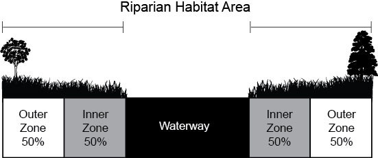
Figure 19.15.130-1. Riparian Habitat Area Components. This figure is based on the Type F Water standard RHA width of 150 feet.
4. Riparian Habitat Areas (RHAs) Required for Classification 4. RHAs shall be established through an approved critical areas assessment and shall:
a. Consist of an undisturbed area of native vegetation or areas identified for restoration established to protect the integrity, functions, and values of the affected habitat;
b. Reflect the sensitivity of the habitat and the type and intensity of human activity proposed to be conducted nearby;
c. Be consistent with the management recommendations issued by the Washington Department of Fish and Wildlife; and
d. Be managed consistent with the provisions of subsection (E)(3) of this section, Riparian Habitat Area (RHAs).
5. Alterations to Waters of the State and Associated RHAs. Activities may be permitted within a pond, lake, water of the state, marine habitat, or associated riparian habitat area when the activity complies with the provisions in this subsection and in accordance with an approved critical area assessment and, if applicable, in accordance with the Shoreline Management Act, Chapter 90.58 RCW, the county’s Shoreline Master Program, and all other applicable state or federal permits.
a. General.
i. All work shall comply with the Washington Department of Fish and Wildlife in-water work window for the applicable species;
ii. The proposal will not degrade the functions or values of the fish habitat or other critical areas.
b. Alteration of Natural Watercourses. Alteration of natural watercourses shall be avoided. If unavoidable, the following provisions shall apply to the alteration:
i. Watercourse alteration projects shall not result in blockage of side channels.
ii. The county shall notify adjacent communities.
iii. The applicant shall maintain the altered or relocated portion of the watercourse to ensure that the flood-carrying capacity is not diminished.
iv. Unavoidable impacts shall be mitigated consistent with mitigation requirements found in subsection F of this section and CCC 19.15.170.
c. Shoreline erosion control measures must also demonstrate that:
i. Natural shoreline processes will be maintained;
ii. Adequate mitigation measures ensure that there is no net loss of the functions or values of riparian habitat as a result of the proposed shoreline erosion control measures;
iii. The proposed shoreline erosion control measures do not result in negative impacts to channel migration corridors;
iv. Impacts to the functions or values of the habitat conservation area shall require appropriate mitigation measures per subsection F of this section and CCC 19.15.170;
v. Streambank stabilization to protect structures from future channel migration is achieved through bioengineering, soft armoring, or recommended techniques in accordance with an approved critical area assessment and the guidelines of the Washington State Integrated Streambank Protection Guidelines (2003, or as amended).
d. In-Stream Structures. On Type F, Type Np, and Type Ns waters, the following provisions shall apply:
i. No structures that prevent the migration of salmonids will be allowed in the portion of water bodies currently used by anadromous fish.
ii. In-stream structures, such as, but not limited to, high flow bypasses, sediment ponds, instream ponds, and retention and detention facilities, are prohibited from RHAs unless they are necessary for the successful development or maintenance of a habitat improvement project.
e. Fills. Fills shall minimize impacts to anadromous fish or their habitat.
f. New Docks and Launching Ramps – Public or Private. On Type F and Type Np waters, launching ramps and new docks may be permitted in accordance with an approved critical area assessment that has demonstrated the following:
i. The project will not result in increased beach erosion;
ii. The development minimizes adverse impacts to fish or wildlife habitat areas or associated wetlands;
iii. Adequate mitigation measures ensure that there is no net loss of the functions or values of aquatic or riparian habitat as a result of the structures.
g. Roads, Trails, Bridges, and Rights-of-Way. Construction of trails, roadways, and bridges may be permitted subject to the following additional standards:
i. There is no other feasible alternative route with less impact on the environment;
ii. The crossing minimizes interruption of downstream movement of wood and gravel;
iii. Trails shall be located in the outer 50 percent of the RHA, except for limited viewing platforms and crossings;
iv. Crossings, where necessary, shall only occur as near to perpendicular with the watercourse as possible;
v. Mitigation for impacts is provided pursuant to a mitigation plan of an approved critical area assessment;
vi. Trails and associated viewing platforms shall not be made of continuous impervious materials.
h. Utility Facilities. New utility lines and facilities may be permitted to cross watercourses, if they comply with the following additional standards:
i. There is no other feasible alternative route with less impact on the environment;
ii. Installation shall be accomplished by boring beneath the scour depth and the saturated zone beneath the watercourse and channel migration zone, where feasible;
iii. The utilities shall cross at an angle greater than 60 degrees to the centerline of the channel in streams or perpendicular to the channel centerline whenever boring under the channel is not feasible;
iv. Crossings shall be contained within the footprint of an existing road or utility crossing where possible;
v. The utility route shall avoid paralleling the stream or following a down-valley course near the channel; and
vi. The utility installation shall not increase or decrease the natural rate of shore migration or channel migration;
vii. Utility facilities which carry liquid petroleum products or any other hazardous substance as defined in Chapter 173-303 WAC may be permitted only when demonstrated by a qualified professional that the design, location, and monitoring of the proposed facility will not cause contaminants to enter the protected resource.
i. Public Flood Protection Measures.
i. New public flood protection measures may be permitted, subject to the county’s review and approval of a critical area assessment.
ii. Expansion on the landward side of existing dikes or levees may be permitted when it is determined through the planning clearance process that the proposed expansion will not result in unavoidable impacts to critical areas or critical area buffers, and that the expansion will be conducted in accordance with CCC 19.15.170(C), Mitigation Sequencing. If the planning clearance is inconclusive, a critical area assessment may be required.
j. Stormwater Management Facilities. Stormwater management facilities, which incorporate infiltration mechanisms, such as dispersion outfalls and bioswales, may be allowed within the outer 25 percent of the RHA or may encroach further into the RHA at discretion of the Director; provided that:
i. No other location is feasible; and
ii. The location of such facilities will not degrade the functions or values of the watercourse or associated RHA.
k. On-Site Sewage Systems and Wells.
i. New on-site sewage systems and individual wells may be permitted within an RHA in accordance with an approved critical area assessment only if accessory to a proposed or approved residential structure, for which it is not feasible to connect to a public sanitary sewer system.
ii. Repairs to failing on-site sewage systems associated with an existing structure shall be accomplished by utilizing one of the following methods that result in the least impact:
(A) Connection to an available public sanitary sewer system;
(B) Replacement with a new on-site sewage system located landward as far as possible, provided the proposed sewage system is in compliance with the Cowlitz County Health Department; or
(C) Repair to the existing on-site septic system.
6. Other Classifications.
a. Classifications 2 and 3. Whenever activities are proposed adjacent to or within Classification 2 or 3 areas, an approved critical area assessment prepared by a qualified professional may be required and must comply with Washington Department of Fish and Wildlife management recommendations for affected species or habitats.
b. Classification 6. Protection for state natural area preserves and natural resource conservation area habitat will be achieved by the Washington State Department of Natural Resources.
c. Classification 7. Protection for areas of rare plant species and high quality ecosystems may require verification and a critical area assessment. Activities should comply with Washington Department of Fish and Wildlife management recommendations for priority habitat species and Washington Department of Natural Resources Heritage Program guidelines.
F. Development Standards – Additional Mitigation Requirements for Fish and Wildlife Habitat Conservation Areas.
1. Mitigation for alterations to fish and wildlife habitat conservation areas shall be consistent with the Washington State Department of Fish and Wildlife and other state or federal agencies’ management recommendations and guidance documents for best practices mitigation. See CCC 19.15.170, Mitigation requirements.
2. Mitigation shall be required to the level or extent necessary to achieve no net loss of critical area functions and values.
3. Proposed mitigation for impacts within fish and wildlife habitat conservation areas may be conditioned by the county on a case-by-case basis using recommendations provided by Washington Department of Fish and Wildlife. [Ord. 16-174 § 2 (Exh. A), 12-20-16.]
19.15.140 Frequently flooded areas.
A. Classifications and Designation. All lands identified in the Federal Emergency Management Agency flood insurance rate maps, as amended, and approved by the county as within the 100-year floodplain are designated as frequently flooded areas. These maps are based on the following: Flood Insurance Study – Cowlitz County Unincorporated Areas.
B. Development Limitations. All development within designated frequently flooded areas shall comply with Chapter 16.25 CCC, Floodplain Management, as now or hereafter amended. [Ord. 16-174 § 2 (Exh. A), 12-20-16.]
19.15.150 Geologically hazardous areas.
A. Designation of Geologically Hazardous Areas.
1. Designation. Geologically hazardous areas include areas susceptible to erosion, sliding, earthquake, or other geological events. They pose a threat to the health and safety of citizens when incompatible development is sited in areas of significant hazard. Such incompatible development may not only place itself at risk, but also may increase the hazard to surrounding development and use. Areas susceptible to one or more of the following types of hazards shall be designated as a geologically hazardous area and are further described in later sections:
a. Seismic hazard;
b. Mine hazard;
c. Volcanic hazard;
d. Erosion hazard; and
e. Landslide hazard.
2. Exemptions. Activities that are exempt from the requirements of this section can be found in CCC 19.15.070, Exemptions.
B. Mapping of Geologically Hazardous Areas. The approximate location and extent of geologically hazardous areas are shown on the adopted critical area maps listed in CCC 19.15.110. They are a reference and do not provide a final critical area designation.
C. Development Standards – General Requirements for All Geologically Hazardous Areas.
1. Alterations. Alterations of geologically hazardous areas or associated buffers may only occur for activities that:
a. Will not increase the threat of the geological hazard to adjacent properties beyond predevelopment conditions;
b. Will not adversely impact other critical areas;
c. Are designed so that the hazard to the project is eliminated or mitigated to a level equal to or less than predevelopment conditions; and
d. Are recommended by a qualified professional in a signed and stamped geologic hazards assessment or geotechnical engineering report, whichever is required by this chapter.
2. Critical Facilities Prohibited. Critical facilities shall not be sited within geologically hazardous areas unless there is no other practical alternative.
3. Utilities Transmission Facilities. Utility facilities which carry liquid petroleum products or any other hazardous substance as defined in Chapter 173-303 WAC may be permitted within geologically hazardous areas only when demonstrated by a qualified professional that the design and location of the proposed facility will not cause adverse impacts.
D. Seismic Hazard Areas.
1. Designation.
a. For the purposes of this classification, a seismic hazard area is any area subject to:
i. Underlying deposits indicative of a risk of liquefaction during a seismic event;
ii. Areas subject to slope failure, including lateral spreading, during a seismic event;
iii. Areas subject to surface faulting during a seismic event;
iv. Areas that are at risk of mass wasting due to seismic forces.
b. Seismic hazard areas are indicated by:
i. A Zone D1 or higher rating as defined by the Seismic Risk Map of the United States adopted by the Washington State Legislature and defined in the International Residential Code (IRC).
ii. Areas with Site Class D, D to E, E, and F as defined by the Site Class Map of Cowlitz County, by Washington State Department of Natural Resources or the International Building Code (IBC).
2. Development Standards – Specific Requirements. All development within areas that meet the designation for seismic hazard areas shall comply with the adopted IBC or IRC. No critical area assessment is required.
E. Mine Hazard Areas.
1. Designation. Mine hazard areas are those areas underlain by or affected by mine workings such as adits, gangways, tunnels, drifts, or airshafts, and those areas of probable sink holes, gas releases, or subsidence due to mine workings. Locations may be known or unknown, based upon best available information.
2. Development Standards – Specific Requirements. Activities proposed to be located in mine hazard area shall meet the standards of subsection C of this section, Development Standards – General Requirements for All Geologically Hazardous Areas, and the following specific requirements:
a. Areas identified where mining is known to have occurred shall be required to have a geotechnical assessment.
b. Areas identified where suspected mine activities have occurred may require a geotechnical assessment. A geotechnical assessment will be required if mining activities are visible, such as a shaft or pit.
F. Volcanic Hazard Areas.
1. Preamble. The eruption of Mt. St. Helens on May 18, 1980, was the most destructive volcanic eruption in the history of the United States with respect to economic impact and loss of life and property. Although a majority of the volcano and its summit are located in Skamania County, the mountain is the source of four river drainages that pass through Cowlitz County to the Columbia River, and the western flank of the mountain, including portions of the Mt. St. Helens National Monument, is within Cowlitz County.
Like the other volcanoes in the Cascade Volcanic Arc, scientists cannot precisely predict when Mt. St. Helens will erupt, the area of land that will be affected, or the force of future eruptions. However, research does provide a record of areas that have been affected by volcanic activity throughout the volcano’s history and the types of hazards that have occurred in those areas. The flowage hazard zones designated below are the results of such research by the United States Geological Society and indicate areas of historic impacts. The research is not intended to indicate that a future volcanic eruption will affect those areas, or that areas not included in the flowage hazard zones will not be affected. Instead, it is information that should be used to make property owners aware of the historical forces that have shaped their land in the past and that have the potential to do so again in the future.
However, because there is potential for economic damage and loss of life and property, Cowlitz County has elected to restrict the development activities within the county that fall very close, within a five-mile radius, to the volcanic cone. This area primarily contains land designated as Flowage Hazard Zone 1 that is also within the Mt. St. Helens National Monument, but also includes some land designated as Flowage Hazard Zone 2. Because of their proximity to the volcanic cone, these areas should not be allowed to increase in population or be developed with permanent structures. Additionally, due to the extensive volumes of sediment flowing down the North Fork of the Toutle River and the potential risk of increased flows in the event of a future eruption, Cowlitz County has also elected to require that development upriver of the North Fork Toutle River Sediment Retention Structure be accompanied by an evacuation and emergency management plan.
2. Designation. Volcanic hazard areas are those areas identified as being within the Volcanic Hazard Zone 1, demarcated by a five-mile radius based on the center of the cone of Mt. St. Helens and the mapped extents of Zone 1, Zone 2 and Zone 3 shown on the Cowlitz County adapted map of the Mount St. Helens Flowage-Hazard Zones Map, 1995, United States Geological Society. These areas can be subject to pyroclastic flows, lava flows, debris avalanche, and inundation by debris flows, lahars, mudflows, or related flooding resulting from volcanic activity.
a. Volcanic Hazard Zone 1. The area within the five-mile radius is indicated as having the highest risk of being affected by potential future volcanic activity, and is the only area with development restrictions based on volcanic hazard risk.
b. Flowage Hazard Zone 1. Areas that have been and could potentially be subject to high- density volcanic flows including lava flows and lahars that are constrained by topographic channels proximal to the volcanic source. The eruptive forces that can occur in Zone 1 can occur so rapidly after an eruption that once the eruption has begun, it is too late to attempt evacuation.
c. Flowage Hazard Zone 2. Areas subject to low-density volcanic flows including pyroclastic surges that are less constrained by topography. The eruptive forces that can occur in Zone 2 can occur so rapidly after an eruption that once the eruption has begun, it is too late to attempt evacuation.
d. Flowage Hazard Zone 3. Areas subject to inundation by well-channelized lahars caused by volcanic activity.
3. Development Standard – Specific Requirements.
a. All Volcanic and Flowage Hazard Zones. All new recorded plats and short plats resulting from subdivisions or short subdivisions shall include a notice stating that the lots are located within a volcanic or flowage hazard zone and indicating which specific zone applies.
b. Volcanic Hazard Zone 1.
i. Allowable Uses.
(A) Passive recreational uses, which may include hiking, boating, fishing, etc.;
(B) Maintenance and repair of existing structures, roads, trails, educational facilities, and serviceable structures;
(C) Agriculture and forestry activities;
(D) Exploratory or scientific research, fish and wildlife enhancement projects, or similar such activities.
c. Flowage Hazard Zones 1, 2, and 3.
i. For areas within all flowage hazard zones along the North Fork Toutle River upriver of the North Fork Toutle River Sediment Retention Structure proposals must include an evacuation and emergency management plan. At a minimum, the evacuation and emergency plan must demonstrate that the evacuation route has been determined to not contain any other potential natural hazards, such as landslide or flood hazards, that could cause a blockage or destruction of the evacuation route during an event (i.e., seismic event triggers a landslide that results in the evacuation route becoming impassible).
ii. A critical areas assessment is not required.
G. Erosion Hazard Areas.
1. Designation. Erosion hazard areas are those areas identified by the U.S. Department of Agriculture’s Natural Resources Conservation Service as having a “severe” or “very severe” erosion hazard. Erosion hazard areas are also those areas impacted by shore land and/or streambank erosion and those areas within a stream’s channel migration zone.
2. Development Standards – Specific Requirements. Uses and activities shall conform to the following standards:
a. Protection of Erosion Hazard Area. Modification of topography and vegetation in an erosion hazard area shall be limited in order to preserve long-term stability of sensitive slopes, reduce erosion potential and stormwater runoff, and preserve related ecological values.
b. Erosion Control Plan. An erosion control plan shall:
i. Demonstrate that development activities conform to existing topography of the site and minimize topographic modification, foundations conform to the natural contours of the slope and are stepped/tiered where possible;
ii. Demonstrate that roads, driveways and other vehicular access, trails, walkways, and parking areas are designed with lower gradients and/or are parallel to the natural contours of the site;
iii. Include stabilization best management practices (BMPs) such as temporary/permanent seeding, mulching, geotextiles, sod stabilization, vegetative buffer strips, protection of trees and preservation of mature vegetation;
iv. Ensure all exposed and disturbed soils shall be stabilized by suitable and timely application of BMPs;
v. Demonstrate that no exposed or disturbed soils shall be allowed to overwinter without erosion control BMPs in place;
vi. Preserve existing vegetation and undergrowth where feasible;
vii. Ensure cut and fill slopes shall be designed and constructed to minimize erosion;
viii. Provide stabilization to adequately prevent erosion of conveyance outlets and streambanks;
ix. Demonstrate that clearing, grading, and impervious surfaces shall be minimized.
c. Seasonal Restriction.
i. Clearing activities that disturb the soil shall be allowed from May 1st to October 1st provided that the county may extend or shorten the dry season on a case-by-case basis, except that timber harvest, not including brush clearing or stump removal, may be allowed pursuant to an approved forest practice permit;
ii. Outside of the designated dry season, clearing activities that disturb the soil may occur only when demonstrated by a qualified professional that no increased risk to erosion hazard and buffer areas will occur from clearing activities.
d. Drainage Plan. A drainage plan shall be developed by a qualified professional that includes:
i. Surface drainage, including downspouts, shall avoid draining to erosion hazard areas. Drainage originating above an erosion hazard area shall be collected and directed by tight line drain, and provided with an energy dissipative device for discharge to a swale or other acceptable natural drainage areas.
ii. The following uses and activities shall be permitted on severe erosion hazard areas only where analysis by a qualified professional finds that such systems will not result in an increase in erosion. A qualified professional shall design said systems. The qualified professional shall also provide verification to the county that the systems are installed as designed and function as predicted:
(A) Stormwater retention and detention systems, including percolation systems utilizing buried pipe;
(B) On-site sewage disposal system drainfields. The septic system drainfield must be in compliance with the regulations of the Cowlitz County Health Department or its successors; and
(C) Utility lines and pipes.
H. Landslide Hazard Areas.
1. Designation. Landslide hazard areas are areas potentially subject to landslides based on a combination of geologic, topographic, and hydrologic factors. They include areas susceptible because of any combination of bedrock, soil, slope (gradient), slope aspect, structure, hydrology, or other factors. Examples of these may include, but are not limited to, the following:
a. Areas of identified landslide hazards, including:
i. Those areas mapped by the Department of Natural Resources 2006 Digital Landslide Inventory and/or shown on the Geologic Hazard Map of Cowlitz County (see CCC 19.15.110 for full map references). Landslide hazard areas are those areas shown with active or inactive landslides, active or inactive scarps, and potentially unstable slopes;
ii. Areas designated as quaternary slumps, earthflows, mudflows, lahars, or landslides on maps published by the U.S. Geological Survey or Washington State Department of Natural Resources;
iii. Areas with all three of the following characteristics:
(A) Slopes steeper than 15 percent;
(B) Hillsides intersecting geologic contacts with a relatively permeable sediment overlying a relatively impermeable sediment or bedrock; and
(C) Springs or groundwater seepage;
iv. Slopes that are parallel or subparallel to planes of weakness (such as bedding planes, joint systems, and fault planes);
v. Slopes. A slope is delineated by establishing its toe and top and is measured by averaging the inclination (dividing the vertical rise by the horizontal run) over at least 10 feet of vertical rise.
(A) Slopes having gradients steeper than 80 percent or 39 degrees over any distance; or
(B) Slopes of 33 percent or 18 degrees or steeper where there is a vertical relief of 10 or more feet, except when the area is composed of consolidated rock;
vi. Areas potentially unstable because of rapid stream incision, streambank erosion, and/or undercutting by wave action;
vii. Areas that show evidence of, or are at risk from, snow avalanches; and
viii. Areas located in a confined stream channel or on an active alluvial fan, presently or potentially subject to inundation by debris flows or catastrophic flooding.
2. Development Standards – Specific Requirements. Uses and activities permitted shall conform to the following standards:
a. Protection of Landslide Area and Buffer. The landslide hazard area and associated buffer shall be protected from disturbance. Modification of topography and vegetation in landslide hazard areas shall be stringently limited in order to preserve long-term stability of sensitive slopes, reduce erosion potential and stormwater runoff, and preserve related ecological values.
b. Buffers. A buffer shall be established from all edges of landslide hazard areas. The minimum dimension of the buffer shall be 50 feet from the edge of the landslide hazard area.
i. Buffer Reduction. The buffer may be reduced to a minimum of 25 feet at the sides of a landslide hazard area when a qualified professional demonstrates that the reduction will adequately protect the proposed development, adjacent developments, and uses and the subject critical area. No reductions are allowed for developments uphill or downslope from landslide hazard areas.
ii. Buffer Use. Where reduction of the buffer is not permitted, development encroachment within the buffer area may be allowed provided a qualified professional demonstrates that site alterations will not impact a landslide area and/or the adjacent properties.
iii. Increased Buffer. The buffer may be increased where the Director or a qualified professional determines a larger buffer is necessary to prevent risk of damage to proposed and existing development.
iv. The buffer shall be clearly staked before and during any construction or clearing.
c. Design and Development Standards. Development or alterations within a landslide hazard area and/or buffer shall be designed to meet the following requirements. Deviations from one or more of these standards may be permitted where it can be demonstrated by a qualified professional that an alternative design provides equal or greater protection of the critical area and proposal. The basic development design standards are:
i. Structures and improvements shall be located to avoid landslide hazard areas and other critical areas;
ii. Structures and improvements shall minimize alterations to the natural contour of the slope, and foundations shall be tiered where possible to conform to existing topography;
iii. Structures and improvements shall be located to preserve the most critical portion of the site and its natural landforms and vegetation;
iv. The proposed development shall not result in an increase in surface water discharge or sedimentation to adjacent properties;
v. Development shall be designed to minimize impervious lot coverage;
vi. Vegetation Retention.
(A) Removal of vegetation from a landslide hazard area or related buffer shall be permitted only when approved by a qualified professional; and
(B) If the landslide area and buffer lacks adequate vegetation, a vegetation restoration plan or other slope stability measures may be required;
vii. Seasonal Restriction.
(A) Clearing activities that disturb the soil shall be allowed from May 1st to October 1st; provided, that the county may extend or shorten the dry season on a case-by-case basis, except that timber harvest, not including brush clearing or stump removal, may be allowed pursuant to an approved forest practice permit;
(B) Outside of the designated dry season, clearing activities that disturb the soil may occur only when demonstrated by a qualified professional that no increased risk to landslide hazard and buffer areas will occur from clearing activities;
viii. Utility Lines and Pipes. Utility lines and pipes shall be permitted in landslide hazard areas only when the applicant demonstrates that no other practical alternative is available;
ix. Drainage.
(A) Surface drainage, including downspouts, shall not be directed across the face of a hazard area. If drainage must be discharged from the top of a hazard area to its toe, it shall be collected above the top and directed to the toe by tight line drain, and provided with an energy-dissipating device at the toe for discharge to a swale or other acceptable natural drainage areas.
(B) Stormwater retention and detention systems, including percolation systems utilizing buried pipe, are strongly discouraged unless a geotechnical assessment indicates such a system shall not affect slope stability and the systems are designed by a licensed civil engineer. The licensed civil engineer shall also certify that the systems are installed as designed;
x. Sewage Disposal Systems. On-site sewage disposal systems, including drainfields, shall be permitted within landslide hazard areas and related buffers only where demonstrated by a qualified professional to not increase the potential landslide hazard impact to the proposed development or surrounding developments.
I. Critical Area Assessment – Requirements for Geologically Hazardous Areas.
1. Preparation by a Qualified Professional. A qualified professional shall prepare critical areas assessments and geotechnical reports.
2. Geologic Hazards Assessment/Reports. A geologic hazards assessment is required for all proposals within erosion hazard areas and landslide hazard areas. Where the applicant can clearly demonstrate to the Department through submittal of a geotechnical assessment that the regulated activity or any related site alterations will not impact a landslide or erosion hazard area or the adjacent properties, the requirements for a geotechnical report will be waived. A geotechnical report will be required when the assessment does not clearly demonstrate that the development activities do not impact the landslide and/or erosion hazard area or the adjacent properties, the geotechnical assessment recommends additional geotechnical study, and/or the development activity is within an identified active landslide hazard area.
3. Site Plan(s) – Assessments and Reports. The following information shall be provided at a minimum:
a. The type and extent of geologic hazard areas and buffers on, adjacent to, within 200 feet of, or that are likely to impact the proposal;
b. Proposed development activity area, including the location of existing and proposed structures, septic drainfield and reserve areas, clearing limits, fill locations, storage of materials, and drainage facilities;
c. Dimensions of the proposed development activity to the property lines, critical areas, landslide scarp and slide mass;
d. A contour map of the proposed site, at a scale of one inch equals 20 feet or other scale as deemed appropriate by the Department. Slopes shall be clearly delineated for the ranges between 15 percent and 32 percent, 33 percent and 79 percent, and 80 percent or greater, including the height of slope, slope gradient, and cross-section of the project area;
e. The location and type of surface water runoff features including the location of springs, seeps, or other surface expressions of groundwater on or within 200 feet of the project area or that have potential to be affected by the proposal; and
f. When site-specific conditions indicate the necessity, the Department may require the topographic data to be field surveyed.
4. Geotechnical Assessment. A geotechnical assessment is an overview of site conditions and a professional evaluation of the need for additional studies prior to development on the property. The geotechnical assessment is intended to be a limited study of geological hazards (i.e., landslide, liquefaction, erosion) at a site, and does not include the collection of any subsurface soil, rock and groundwater data. If determined to be necessary, the qualified professional will recommend the preparation of a detailed geotechnical report that includes the investigation of subsurface soil, rock and groundwater conditions to better assess the geological site hazards. The geologic assessment shall include, but not be limited to:
a. A field reconnaissance of the site and vicinity;
b. A detailed description of the project;
c. Site plan of the area based on the criteria listed within subsection (I)(3) of this section, Site Plan(s) – Assessments and Reports;
d. Feasibility of the site for the proposed development activity;
e. A description of the surface and subsurface geology, hydrology, soils, and vegetation found in the project area;
f. A discussion of the project and its relationship to the geologic hazards found on site, which may include the type and extent of geologic hazard areas and buffers on, adjacent to, within 200 lateral feet of, or that are likely to impact the proposal or be impacted by the proposal;
g. An overview of any field investigations, published data, and references; data and conclusions from past assessments of the site; and site-specific measurements, tests, investigations, or studies that support the identification or lack of geologically hazardous areas;
h. If applicable, an identification of any areas of the site recommended to be avoided by any aspect of the proposed development;
i. If necessary, identification of mitigation measures needed to address any anticipated geologic problems;
j. If applicable, development recommendations for the proposed activities. These recommendations should include, but are not limited to, structure and septic system setbacks from geologic hazard areas if less than or greater than the minimum established buffer or do not meet IBC setback requirements, foundation design, filling and excavation, erosion control, drainage and site preparations;
k. Discussion regarding the need for follow-up studies that should be conducted, such as geotechnical engineering reports, additional subsurface exploration or more extensive soil reports;
l. Demonstration that all applicable development standards are met.
5. Geotechnical Engineering Report. A geotechnical engineering report will be required for any development proposal on a site containing an active landslide hazard area or landslide and/or erosion hazard areas that were identified through the geotechnical assessment for further geotechnical analysis. It is the responsibility of the qualified professional to provide a report and design recommendations that are appropriate for existing site conditions and the proposed development. The geotechnical engineering report shall be completed and stamped by a qualified professional and shall present results and engineering recommendations.
The geotechnical report will include, at the minimum, the following:
a. The requirements listed within the geotechnical assessment criteria;
b. Site history – description of any prior grading, soil instability or slope failure;
c. Subsurface data – logs of borings, test pits, and other exploratory methods; soil and rock stratigraphy; groundwater levels, including seasonal changes and laboratory tests;
d. The results of any laboratory tests – laboratory data and soil index properties for soil samples;
e. The effect construction and placement of structures will have on the slope over the estimated life of the structure;
f. Vulnerability of the site to erosion;
g. The location, dimensions and estimated depth of any area(s) of slope instability on the site;
h. Description of analysis performed and results of that analysis;
i. An estimate of the bluff retreat rate that recognizes and reflects potential catastrophic events such as seismic activity or a 100-year storm event;
j. Assumed or established site and subsurface conditions used in the slope stability analysis (e.g., slope dimensions of any landslides, thickness and strengths of soil and rock units, depth to failure plane if any, groundwater levels, etc.);
k. Consideration of the run-out hazard of landslide debris and/or the impacts of landslide run-out on downslope properties;
l. Parameters for design of site improvements, including:
i. Building limitations;
ii. Suitability of on-site soil for use as fill;
iii. Soil compaction criteria;
iv. Proposed angles and heights of cut and fill slopes;
v. Appropriate foundations and retaining structures. These should include allowable bearing capacities and lateral earth pressures appropriate for the design of foundations and walls, installation considerations, and estimates of settlement performance;
vi. Recommendations for drainage and subdrainage and utility line improvements for collection, transport, treatment, discharge, and/or recycling of water, including consideration of on-site septic system disposal volumes where the additional volume will affect the landslide hazard area;
vii. Earthwork recommendations, including clearing and site preparation criteria, fill placement, temporary and permanent slope inclinations and protection, and temporary excavation support, if necessary;
viii. Mitigation of adverse site conditions, including slope stabilization measures and seismically unstable soils, if appropriate;
ix. Stability.
(A) For terrain containing no obvious instability or identified landslides, the proposed site grading or structures shall not reduce the existing slope stability on the development site or adjacent sites to less than a factor of safety of 1.5 for static conditions and 1.2 for dynamic conditions.
(B) For terrain containing active or inactive landslides or for proposed structures, cuts, fills or roads near designated or identified areas of instability, the proposed development shall not decrease the factor of safety below the limits of 1.5 for static conditions and 1.2 for dynamic conditions at or adjacent to the development location.
(C) The Director may consider lower factors of safety, if the qualified professional provides detailed explanation that satisfies the Director regarding why lower factor of safety values presents an acceptable level of risk to the development.
(D) Designs that require regular or periodic maintenance to maintain their level of function are excluded from long-term slope stabilization measures.
6. Incorporation of Previous Study. Where a valid critical areas assessment or geotechnical engineering report has been prepared within the last five years for a specific site, and where the proposed land use activity and surrounding site conditions are unchanged, said assessment or report may be incorporated into the required critical area assessment. The applicant shall submit a hazards assessment detailing any changed environmental conditions associated with the site.
7. Mitigation of Long-Term Impacts. When hazard mitigation is required, the mitigation plan shall specifically address how the activity maintains or reduces the preexisting level of risk to the site and adjacent properties on a long-term basis (equal to or exceeding the projected life span of the activity or occupation). Proposed mitigation techniques shall be considered to provide long-term hazard reduction only if they do not require regular maintenance or other actions to maintain their function. Mitigation may also be required to avoid any increase in risk above the preexisting conditions following abandonment of the activity. [Ord. 16-174 § 2 (Exh. A), 12-20-16.]
19.15.160 Critical aquifer recharge areas.
A. Critical Aquifer Recharge Areas Designation and Classification.
1. Designation. Critical aquifer recharge areas (CARAs) are those areas with a critical recharging effect on aquifers used for potable water as defined by WAC 365-190-030(2). CARAs have prevailing geologic conditions that create potential for contamination of groundwater resources. Aquifer recharge areas are rated based on water-bearing formation type, soil infiltration, soil restrictive layer presence, soil permeability, annual precipitation, water supply well density, and presence of Group A or B wellhead protection areas (WHPAs) are categorized according to the following standards and mapped on Cowlitz County CARAs Map:
a. Severe Aquifer Susceptibility. Those areas within Group A 10-year time of travel wellhead protection areas (WHPAs) or Group B WHPAs where geologic conditions allow for rapid recharge with little restrictive layer protection, high soil permeability, and other similar factors.
b. Moderate Aquifer Susceptibility. Those areas within Group A 10-year time of travel WHPAs or Group B WHPAs where geologic conditions allow for moderate recharge with moderate restrictive layer protection, moderate soil permeability, and other similar factors.
c. Slight Aquifer Susceptibility. Those areas within Group A 10-year time of travel WHPAs or Group B WHPAs where geologic conditions provide low permeability and infiltration, more restrictive geology, and/or lower levels of precipitation.
d. If special groundwater management areas or susceptible groundwater management areas are established in Cowlitz County in accordance with WAC 173-200-090 or 173-100-010, respectively, these areas shall considered areas of special protection and designated with severe susceptibility.
e. In the event that new Group A or Group B wells are developed in Cowlitz County, the areas around those wells will be considered CARAs using the Cowlitz County CARAs Map in accordance with the severe, moderate, and slight aquifer susceptibility characteristics described above.
2. Exemptions. Activities that are exempt from the requirements of this section can be found in CCC 19.15.070, Exemptions.
B. Mapping of Critical Aquifer Recharge Areas (CARAs). The approximate location and extent of CARAs are those lands meeting the classification criteria in subsection A of this section and mapped on the Cowlitz County CARAs Map. CARAs categories are based on an aquifer susceptibility index developed using the following data: water-bearing formation type, soil infiltration, soil restrictive layer presence, soil permeability, annual precipitation, and water supply well density.
C. Critical Area Assessment – Additional Requirements for Critical Aquifer Recharge Areas (CARAs). In addition to the general critical area assessment requirements of CCC 19.15.090(F)(2), Critical Area Assessments, for CARAs must meet the requirements of this section.
1. Preparation by a Qualified Professional. A qualified professional shall prepare an aquifer recharge area critical area assessment.
2. Level One Hydrogeologic Assessment. A level one hydrogeologic assessment shall include the following site and proposal related information at a minimum:
a. Available information regarding geologic and hydrogeologic characteristics of the site including the surface location of all CARAs located on site or immediately adjacent to the site, and permeability of the unsaturated zone;
b. Groundwater depth, flow direction, and gradient based on available information;
c. Currently available data on wells and springs within 1,300 feet of the project area;
d. Location of other critical areas, including surface waters, within 1,300 feet of the project area;
e. Available historic water quality data for the area to be affected by the proposed activity; and
f. Best management practices proposed to be utilized.
3. Level Two Hydrogeologic Assessment. A level two hydrogeologic assessment shall include the following site- and proposal-related information at a minimum, in addition to the requirements for a level one hydrogeological assessment:
a. Historic water quality data for the area to be affected by the proposed activity compiled for at least the previous five-year period;
b. Groundwater monitoring plan provisions;
c. Discussion of the effects of the proposed project on the groundwater quality and quantity, including:
i. Predictive evaluation of groundwater withdrawal effects on nearby wells and surface water features; and
ii. Predictive evaluation of contaminant transport based on potential releases to groundwater; and
iii. A spill plan that identifies equipment and/or structures that could fail, resulting in an impact. Spill plans shall include provisions for regular inspection, repair, and replacement of structures and equipment that could fail.
D. Development Standards – General Requirements.
1. Activities may only be permitted in a critical aquifer recharge area if the applicant can show that the proposed activity will not cause contaminants to enter the aquifer and that the proposed activity will not adversely affect the recharging of the aquifer.
2. The proposed activity must comply with the water source protection requirements and recommendations of the Washington State Department of Health and the Cowlitz County Health Department.
3. The proposed activity must be designed and constructed in accordance with the locally adopted surface water management and/or stormwater regulations. If no surface water or stormwater management regulations have been adopted at the time of application, this standard does not apply.
4. Hydrogeologic Assessment.
a. For all proposed activities in a critical aquifer recharge area with slight susceptibility, no hydrogeologic assessment is required unless requested by the Director. All activities must meet the requirements of this chapter.
b. For all proposed activities in a critical aquifer recharge area with moderate susceptibility, a level one hydrogeological assessment is required.
c. For the following activities in a critical aquifer recharge area with moderate susceptibility, a level two hydrogeologic assessment shall be required for any of the following proposed activities:
i. Activities that result in new impervious surface equal to 15 percent or more of the parcel, or 15 percent or more of the sum total of the parcels impacted area;
ii. The use of hazardous substances, other than household chemicals; or
iii. Any other activity determined by the Director likely to have an adverse impact on groundwater quality or quantity or on the recharge of the aquifer.
d. Activities within a parcel that occur within one year of each other shall be considered to be the same project and subject to the sum of the areas impacted. The period of occurrence shall be measured from the acceptance of one project to the vesting date of the next project.
e. For all proposed activities in a critical aquifer recharge area with severe susceptibility, a level two hydrogeologic assessment is required.
E. Development Standards – Specific Uses.
1. Aboveground and Underground Storage Tanks and Vaults. Aboveground or underground storage tanks or vaults for the storage of hazardous substances or dangerous wastes as defined in Chapter 173-303 WAC, Dangerous Waste Regulations, or any other substances, solids, or liquids in quantities identified by the County Health Department, consistent with Chapter 173-303 WAC, as a risk to groundwater quality, shall conform to CCC 16.05.060, the International Fire Code, and Chapter 173-360 WAC, Underground Storage Tank Regulations.
2. Vehicle Repair and Servicing and Accessory Uses.
a. Activities must be conducted over impermeable pads and within a covered structure capable of withstanding normally expected weather conditions. Chemicals used in the process of vehicle repair and servicing or accessory uses must be stored in a manner that protects them from weather and provides containment should leaks occur.
b. No dry wells shall be allowed in CARAs on sites used for vehicle repair and servicing. Dry wells existing on the site prior to facility establishment must be abandoned using techniques approved by the state Department of Ecology prior to commencement of the proposed activity.
3. Utility Transmission Facilities. Utility transmission facilities which carry liquid petroleum products or any other hazardous substance as defined in Chapter 173-303 WAC may be permitted within severe and moderate susceptibility CARAs only when demonstrated by a qualified professional that the design, location, and monitoring of the proposed facility will not cause contaminants to enter the aquifer and that the proposed activity will not adversely affect the recharging of the aquifer.
F. Uses Prohibited from Moderate and Severe Susceptibility CARAs.
1. Landfills. Landfills, including hazardous or dangerous waste, municipal solid waste, special waste, wood waste, and inert and demolition waste landfills;
2. Wood Treatment Facilities. Wood treatment facilities that allow any portion of the treatment process to occur over permeable surfaces (both natural and manmade);
3. Storage, Processing, or Disposal of Radioactive Substances. Facilities that store, process, or dispose of radioactive substances. [Ord. 16-174 § 2 (Exh. A), 12-20-16.]
19.15.170 Mitigation requirements.
A. Impacts. The applicant shall avoid all impacts that degrade the functions and values of a critical area or areas. Unless otherwise provided in this chapter, all critical areas mitigation required pursuant to this chapter (either as a permit condition or as the result of an enforcement action) shall use the best available science in accordance with an approved critical area assessment, mitigation plan, and State Environmental Policy Act documents so as to result in no net loss of critical area functions and values.
B. Mitigation Timing. When a mitigation plan is required, the plan shall be approved by the Department prior to any site disturbance at the development site. The Department may seek assistance from resource agencies prior to making a decision.
It is preferred that compensatory mitigation projects be completed prior to activities that will impact wetlands. At the least, compensatory mitigation shall be completed immediately following disturbance and prior to use or occupancy of the action or development. Construction of mitigation projects shall be timed to reduce impacts to existing fisheries, wildlife, and flora.
The Director may authorize a one-time temporary delay of implementation of the mitigation plan, up to 120 days, in completing minor construction and landscaping when environmental conditions could produce a high probability of failure or significant construction difficulties. The delay shall not create or perpetuate hazardous conditions or environmental damage or degradation, and the delay shall not be injurious to the health, safety, and general welfare of the public. The request for the temporary delay must include a written justification that documents the environmental constraints that preclude implementation of the mitigation plan. The justification must be verified and approved by the Director.
C. Mitigation Sequencing. Applicants shall demonstrate that all reasonable efforts have been examined with the intent to avoid and minimize impacts to critical areas. When an alteration to a critical area is proposed, such alteration shall be avoided, minimized, or compensated for in the following sequential order of preference:
1. Avoiding the impact altogether by not taking a certain action or part of an action;
2. Minimizing the impact(s) by limiting the degree or magnitude of the action and its implementation, by using appropriate technology, or by taking affirmative steps, such as project redesign, relocation, or timing, to avoid or reduce impacts;
3. Rectifying the impact to wetlands, critical aquifer recharge areas, frequently flooded areas, riparian habitat, and habitat conservation areas by repairing, rehabilitating, or restoring the affected environment to the historical conditions or the conditions existing at the time of the initiation of the project;
4. Minimizing or eliminating the hazard by restoring or stabilizing the hazard area through engineered or other methods;
5. Reducing or eliminating the impact or hazard over time by preservation and maintenance operations during the life of the action;
6. Compensating for the impact to wetlands, critical aquifer recharge areas, frequently flooded areas, riparian habitat, and habitat conservation areas by replacing, enhancing, or providing substitute resources or environments; and
7. Monitoring the hazard or other required mitigation and taking remedial action when necessary.
D. Type and Location of Mitigation. Compensatory mitigation for impacts to critical areas and their buffers shall be either in-kind and on-site, or in-kind and within the same stream reach, or subbasin, except when all of the following apply:
1. There are no reasonable on-site or in-subbasin opportunities or on-site and in-subbasin opportunities do not have a high likelihood of success; and
2. Off-site mitigation has a greater likelihood of providing equal or improved critical area functions than the impacted critical area; and
3. One of the following applies:
a. Established watershed goals for water quality, flood or conveyance, habitat, or other critical area functions have been established and strongly justify location of mitigation at another site; or
b. Credits from a state-certified habitat and/or wetland mitigation bank are used as mitigation and the use of credits is consistent with the terms of the bank’s certification under Chapter 173-700 WAC.
E. Mitigation Performance Standards.
1. Mitigation sites shall be located to preserve or achieve contiguous wildlife habitat corridors to minimize the isolating effects of development on habitat areas, where applicable.
2. Mitigation of alterations to habitat conservation areas shall achieve no net loss of water quality, biological or hydrologic functions.
3. The performance standards set forth in this subsection may be modified at the Director’s discretion if the applicant demonstrates that greater habitat functions, on a per function basis, can be obtained as a result of alternative mitigation measures.
4. Mitigation and associated buffers will take place on land controlled by the applicant, or the applicant may obtain a written agreement from the affected property owner(s) that acknowledges any increased buffers and their impacts to the property(s). The agreement must be in a form approved by the Director and be recorded with the Auditor’s office.
F. Mitigation Plan Requirements. At a minimum, all mitigation plans shall meet the following standards:
1. The applicant or a qualified professional hired by the applicant as required in this chapter shall prepare the mitigation plan. The plan shall be acceptable to the Director.
2. The mitigation plan shall include:
a. Existing critical area features (where applicable):
i. Existing and proposed critical area acreage;
ii. Existing functions and values of the critical area;
iii. Existing flora and fauna;
iv. Surface and subsurface hydrologic conditions, including an analysis of existing and future hydrologic regime and proposed hydrologic regime for enhanced, created, or restored mitigation areas;
v. Soil and substrate conditions, topographic elevations;
vi. Existing and proposed site conditions adjacent to the critical area;
vii. Maps of the mitigation area; and
viii. Written assessment of the mitigation area;
b. A contingency plan in the event the stated objectives are not accomplished;
c. Required critical area buffers for existing critical areas and proposed compensation areas;
d. Proof of ownership or written permission from the landowner for use of the mitigation site;
e. A description of impacted functions and values, as well as a description of how those impacts will be mitigated;
f. The selection criteria used to identify an off-site mitigation site, if applicable;
g. Detailed construction plans, including:
i. The proposed construction sequence, timing, and duration;
ii. Grading and excavation details;
iii. Erosion- and sediment-control features;
iv. A planting plan specifying plant species, quantities, locations, size, spacing, and density; and
v. Measures to protect and maintain plants until established;
h. Measurable mitigation objectives, if applicable;
i. A monitoring plan that outlines the schedule for site monitoring (for example, monitoring shall occur in years one, three, and five after site construction) and describes how the monitoring data will be evaluated to determine whether objectives are being met. A monitoring report shall be submitted in each monitoring year to document milestones, successes, problems, and contingency actions. Mitigation projects must be monitored for no fewer than five years following site construction;
j. Where applicable, an evaluation of adverse impacts where mitigation measures will affect adjacent properties.
G. Alternative Mitigation Proposals. The Director may approve alternative critical areas mitigation proposals for mitigation projects of 10 acres or greater that are based on best available science, including but not limited to activities such as advance mitigation and preferred environmental alternatives. Alternative mitigation proposals must provide an equivalent or better level of mitigation of critical area functions and values than would be provided by the strict application of this chapter.
The Director shall consider the following for approval of an alternative mitigation proposal:
1. The project area meets the minimum acreage criteria;
2. For habitat mitigation projects, creation or enhancement of a larger system of natural areas and open space is preferable to the preservation of many individual habitat areas;
3. Mitigation according to subsections C, D, and E of this section is not feasible due to site constraints such as parcel size, stream type, wetland category, or geologic hazards;
4. There is clear potential for success of the proposed mitigation at the proposed mitigation site;
5. The plan shall contain clear and measurable standards for achieving compliance with the specific provisions of the plan. A monitoring plan shall, at a minimum, meet the provisions in subsection (F)(2)(i) of this section;
6. The plan shall be reviewed and approved as part of overall approval of the proposed use;
7. A wetland of a different type is justified based on regional needs or functions and values; the replacement ratios may not be reduced or eliminated unless the reduction results in a preferred environmental alternative;
8. Mitigation guarantees shall meet the minimum requirements as outlined in subsection J of this section;
9. Qualified professionals in each of the critical areas addressed shall prepare the plan;
10. The county may consult with agencies with expertise and jurisdiction over the resources in the review process to assist with analysis and identification of appropriate performance measures that adequately safeguard critical areas. The county may incorporate those agencies’ recommendations into their final project approval criteria.
H. Signs and Fencing of Wetlands and Habitat Protection Areas.
1. Temporary Markers. The outer perimeter of the wetland, habitat protection area, riparian habitat area, or buffer and the limits of those areas to be disturbed pursuant to an approved permit or authorization may be required to be marked in the field in such a way as to ensure that no unauthorized intrusion will occur, and such marking is subject to an inspection by the Director prior to the commencement of permitted activities. This temporary marking shall be maintained throughout construction and shall not be removed until permanent signs, if required, are in place.
2. Permanent Signs. As a condition of any permit or authorization issued, the Director may require the applicant to install permanent signs along the boundary of a wetland, habitat protection area, riparian habitat area, or buffer.
a. Permanent signs shall be made of an enamel-coated metal face and attached to a metal post, or another nontreated material of equal durability or as approved by the Director. Signs must be posted at an interval of one per lot or within sight distance of each other, whichever is less, and must be maintained by the property owner in perpetuity. The sign shall be worded as follows or with alternative language approved by the Director:
Protected Critical Area
Do Not Disturb
Contact Cowlitz County Building and Planning Regarding Uses and Restriction
b. The provisions of subsection (H)(2)(a) of this section may be modified as necessary to assure protection of sensitive features or wildlife.
3. Fencing or Barriers.
a. The Director may condition any permit or authorization to require the applicant to install a permanent fence or natural barrier at the edge of the wetland, wetland buffer, or habitat protection area buffer, when fencing is necessary to minimize future impacts. Natural barriers can include log fences, a five-foot-wide planting of native shrubs generally considered impassible, or other natural barrier approved by the Director.
b. The applicant shall be required to install a permanent fence or impassible natural barrier around the wetland, habitat protection area, or buffer when domestic grazing animals will be present on a site.
c. Fencing or barriers installed as part of a proposed activity or as required in this subsection shall be designed so as to not interfere with species migration, including fish runs, and shall be constructed in a manner that minimizes impacts to the wetland, habitat protection area, and associated buffer.
I. Restoration. Restoration shall be required when a critical area has been altered by the landowner after the adoption of the ordinance codified in this chapter and prior to project approval or when a critical area is temporarily affected by construction or any other temporary phase of a project.
J. Mitigation Guarantees. As part of the mitigation plan the Director may require a mitigation guarantee. The guarantee may include one or more of the following:
1. Deed Restriction. The applicant shall record a deed restriction in the County Auditor’s office declaring that the mitigation area as shown on the exhibits of the approved critical areas permit will be maintained as prescribed in the approved mitigation plan, and that future development activities will not occur within the mitigation area, including the removal of native vegetation or disturbance of the soil.
2. Financial Guarantee. Financial guarantees ensuring fulfillment of the mitigation project, monitoring program, and any contingency measures shall be posted in accordance with the following:
a. The financial guarantee shall be in a form of a surety bond, performance bond, assignment of savings account, or an irrevocable letter of credit guaranteed by an acceptable financial institution with terms and conditions acceptable to the County Attorney.
b. Bonds or other security authorized by this section shall remain in effect until the county determines, in writing, that the standards bonded for have been met. Bonds or other security shall be held by the county for a minimum of the length of the time specified for monitoring in the plan and shall be released after a request by the applicant and a final inspection, but may be held for longer periods when necessary. [Ord. 16-174 § 2 (Exh. A), 12-20-16.]
19.15.180 Subdivisions and short subdivisions.
A. Within All Designated Critical Areas and Associated Buffers.
1. For new lots, applicants shall demonstrate that reasonable efforts have been examined with the intent to avoid and minimize impacts to critical areas.
2. Where avoidance of critical areas is not possible, new lots with building envelopes (for example: home, septic, and potable water locations), access roads and utilities may be permitted within critical areas provided an assessment by a qualified professional demonstrates that the proposal will not adversely impact the critical area or adjacent properties.
3. When building envelopes and access roads or utilities are permitted within a critical area, the project may be required to comply with mitigation requirements in CCC 19.15.170.
B. Erosion and Landslide Hazard Areas. Within erosion hazard areas and landslide hazard areas, subdivisions and short subdivisions may be permitted, provided a vegetation, erosion control, and drainage plan is developed by a qualified professional and implemented as provided in CCC 19.15.150, Geologically hazardous areas.
C. Critical Aquifer Recharge Areas.
1. Open spaces may be required on subdivision and short subdivision proposals overlying areas with moderate or severe aquifer classification.
2. Community/public water systems are encouraged and may be required where site conditions indicate a high degree of potential contamination to individual wells from on-site and off-site sources.
3. It may be required that contaminants be removed from stormwater runoff prior to their point of entry into surface or groundwater resources in accordance with specific plans prepared by a qualified professional to include using available and reasonable best management practices by the Cowlitz County Engineer.
D. Mitigation Guarantees. As part of the subdivision or short subdivision, the Director may require a mitigation guarantee. The guarantee may include one or more of the following:
1. Deed Restriction or Covenants, Codes, and Restrictions. The applicant shall record a deed restriction or include within the covenants, codes, and restrictions for a subdivision or short subdivision in the County Auditor’s office a certification by the owner that the mitigation area as shown on the exhibits of the approved critical areas permit will be maintained as prescribed in the approved mitigation plan and that future development activities will not remove native vegetation or disturb the soil within the mitigation area without prior approval of a critical areas permit.
2. Conservation Tract. The applicant shall record on the face of the plat for the subdivision or short subdivision a conservation tract in accordance with the approved mitigation area as shown on the exhibits of the approved critical areas permit. The plat shall include a note for the conservation tract stating that no future development activities shall occur within the conservation tract without prior approval through a critical areas permit.
3. Financial Guarantee. If mitigation is required for the subdivision or short subdivision, financial guarantees ensuring fulfillment of the mitigation project, monitoring program, and any contingency measures shall be posted in accordance with the following:
a. The financial guarantee shall be in a surety bond, performance bond, assignment of savings account, or an irrevocable letter of credit guaranteed by an acceptable financial institution, or other form with terms and conditions acceptable to the County Attorney.
b. Bonds or other security authorized by this section shall remain in effect until the county determines, in writing, that the standards bonded for have been met. Bonds or other security shall be held by the county for a minimum for the length of the time specified for monitoring in the plan and shall be released after a request by the applicant and a final inspection, but may be held for longer periods when necessary. [Ord. 16-174 § 2 (Exh. A), 12-20-16.]
19.15.190 Reasonable use.
It is the policy of Cowlitz County that private property shall not be taken for public use without just compensation having been made. The property rights of landowners shall be protected from arbitrary and discriminatory actions. To avoid the taking of property without just compensation, this section establishes a reasonable use allowance from standard critical area protection regulations. Reasonable use shall be liberally construed to protect the constitutional property rights of the applicant.
If the application of this chapter would result in denial of reasonable and economically viable use of a property, then a landowner may seek a reasonable use allowance from the standards of this chapter. A reasonable use allowance is intended as a “last resort” when no plan for mitigation and/or variance to other local land use standards can meet the requirements of this chapter and allow the applicant a reasonable economically viable use of his or her property.
A. Reasonable use allowances only apply to compliance with critical area requirements. They do not relieve the applicant of the duty to comply with other local, state, or federal requirements.
B. The burden of proof is on the applicant to provide adequate information for the Director to make a finding of compliance with the requirements of this section.
C. Reasonable use allowance may only be granted for parcels created before the effective date of the ordinance codified in this chapter. Reasonable use allowances cannot be used to justify building on parcels not intended to be used as a building site (e.g., recreational lots, including those platted as common area).
D. Two sets of options are available under the reasonable use allowance.
1. Option One – No Mitigation.
a. A development area of up to 2,500 square feet of development constructed using low impact development practices may be located in a critical area buffer.
b. A development area of up to 1,500 square feet of development constructed using low impact development practices may be located in a critical area.
c. A combined development area of 2,500 square feet of low impact development, with no more than 1,500 square feet located in the critical area and the balance located in the critical area buffer.
2. Option Two – With Mitigation.
a. Up to 10 percent of the parcel, or up to one-half acre, or the minimum necessary to allow for reasonable use of the property, whichever is more, may be developed if adverse impacts to critical area functions and values are mitigated in accordance with CCC 19.15.170.
b. Low impact development practices are encouraged in all development under the reasonable use allowance and are required for all reasonable use allowance development creating a footprint greater than 10,890 square feet (one-quarter acre) in size.
E. Applications for reasonable use allowances are reviewed and approved by the Director.
F. Application for a reasonable use allowance shall include:
1. A description of the proposal, including the proposed site plan;
2. Any related project documents such as applications to other agencies or environmental documents prepared pursuant to the State Environmental Policy Act;
3. Required critical area reports, critical area delineations, and, for the “with mitigation” option, best available science documents supporting the proposal;
4. A copy of proposed or approved stormwater and erosion control plans;
5. A narrative describing anticipated adverse impacts to the functions and values of critical areas, based on best available science, and explaining how the proposal meets the reasonable use allowance approval criteria;
6. Mitigation, Monitoring and Adaptive Management Plans. For the “with mitigation” option, plans meeting the requirements of CCC 19.15.170 for mitigating any adverse impacts or harm that would result in a net loss of the functions and values of critical areas, for monitoring the effectiveness of mitigation actions, and when necessary, for adaptively managing the mitigation project to ensure its success;
7. For the “with mitigation” option, a cost estimate, prepared by a qualified professional, for implementing mitigation and monitoring plans;
8. Financial Guarantee. For the “with mitigation” option, a financial guarantee covering 115 percent of the cost of implementing mitigation and monitoring plans. This guarantee and the associated agreement must meet the requirements of CCC 19.15.170.
G. Reasonable Use Allowance Approval Criteria.
1. The application is complete and includes all applicable items listed in subsection F of this section.
2. The parcel was created before the effective date of the ordinance codified in this section and was established as a building site.
3. The applicant is unable to meet standard critical area protection regulations and the application of CCC 19.15.060 through 19.15.180 would deprive the land owner of all economic or beneficial use of the property.
4. The need for the allowance is not the result of action by current or previous property owners after the effective date of the ordinance codified in this section (e.g., creating new parcels without a feasible building site or means of access).
5. Where possible, proposed development areas are located in such a way as to avoid adverse impacts to the functions and values of critical areas, considering the best available science.
6. The proposed development meets the requirements of either option one (no mitigation) or two (with mitigation).
7. The proposal is consistent with the requirements of subsections C and D of this section.
H. Recording of Approved Allowance, Site Plan, and Notice to Title. The county shall record a copy of the approved reasonable use allowance and site plan, along with a notice to title referencing the plan, with the cost of recordation included in the application fee. [Ord. 16-174 § 2 (Exh. A), 12-20-16.]
19.15.200 Appeals.
Any interpretation or decision made by the Director in the administration of this chapter is final and conclusive unless appealed to the Cowlitz County Hearing Examiner as authorized by Cowlitz County Ordinance No. 95-193. Appeals of decisions made by other bodies shall be as directed by the appropriate county code governing the underlying action.
A. Any person aggrieved by a decision of the Director may, within 30 days following the date of the Department’s written decision, submit an appeal of the Director’s decision. The burden of proof in any appeal is the responsibility of the appellant. Any appeal shall be in written form and filed with the Department together with a fee as established by resolution by the Board. Any appeal shall as a minimum contain the following information:
1. An explanation and description of how the appellant is aggrieved;
2. A statement describing why the appellant believes the decision of the Director is in error and the specific relief sought;
3. A statement showing why upholding an appeal will not be detrimental to public health, safety or welfare, or significantly negate the functions of a critical area, the goals, objectives and policies of the Growth Management Act, and the purposes of this chapter;
4. A statement describing any mitigating measures the appellant proposes to assure that the function of the critical area will not be irrevocably jeopardized in the event the appeal is successful.
B. Upon the filing of an appeal with appropriate fee, the Director shall set forth the time and place for a public hearing before the Hearing Examiner on the matter. If the appeal is filed 20 days or more before the Hearing Examiner’s regularly scheduled monthly meeting, he/she shall hear the appeal at that meeting. For appeals filed within 19 days of the regularly scheduled monthly meeting, the Hearing Examiner shall hear the appeal in the subsequent month.
C. Notice of the time, date and place of the hearing shall be sent to the appellant and the permittee by first class mail prior to the public hearing. Legal notice of the hearing shall be published in a newspaper of general circulation and the subject property shall be posted with the notice not less than 10 days prior to the public hearing.
D. Within 10 days after the public hearing, the Hearing Examiner shall issue a written decision, including findings of fact on which his/her decision is based. Such written decision shall be available to the appellant and the public upon request.
E. The Director shall transmit the application and appeal information to the Hearing Examiner at least five days prior to the public hearing. The Director may provide additional information if the appeal contains material or facts not available prior to the Director’s decision.
F. The Hearing Examiner shall determine if the appeal should be upheld, upheld with conditions, or denied. Any person aggrieved by the decision of the Hearing Examiner regarding a permit pursuant to this chapter may request relief from the Superior Court of Cowlitz County pursuant to state law. [Ord. 16-174 § 2 (Exh. A), 12-20-16.]
19.15.210 Penalties – Violations.
It is a civil infraction for any person to violate this chapter or assist in the violation of this chapter. Violations are subject to the provisions of Chapter 2.06 CCC. Any violation is a public nuisance. Each day a violation exists is a separate violation. Payment of any penalty imposed for a violation does not relieve a person from the duty to comply with this chapter. [Ord. 16-174 § 2 (Exh. A), 12-20-16.]
19.15.220 Fees.
Fees, in the amount established by the Board of County Commissioners, shall be paid to the Department when an application for a planning clearance and permit is filed. [Ord. 16-174 § 2 (Exh. A), 12-20-16.]
19.15.230 Liability for damages.
This chapter shall not be construed to hold the County of Cowlitz, or any officer or employee thereof, responsible for any damages to persons or property by reason of the certification, inspection or noninspection of any building, equipment or property as herein authorized. [Ord. 16-174 § 2 (Exh. A), 12-20-16.]
19.15.240 Severability.
Should any section, clause or provision of this chapter or any code adopted be declared by a court to be invalid, the same shall not affect the validity of the remainder, either in whole or in part. [Ord. 16-174 § 2 (Exh. A), 12-20-16.]
19.15.250 Effective date.
This chapter shall become effective December 20, 2016. [Ord. 16-174 § 2 (Exh. A), 12-20-16.]
See page 6 of “Priority Habitats and Species List,” Washington Department of Fish and Wildlife, 2008, Olympia, Washington. 177 p.