


Article III. OVERLAY DISTRICTS
Chapter 18.10
HEIGHT OVERLAY DISTRICTS
18.10.000 Chapter Contents
Sections:
18.10.020 Height - Generally.
18.10.040 Budd Inlet height district.
18.10.060 State capitol height district.
18.10.080 Sylvester Park height district.
18.10.020 Height –Generally
Buildings and structures shall not exceed the height limitations as specified for the use district in which they are located. See Sections 18.04.080(I), 18.06.100(C) and 18.08.100(B).
(Ord. 5830 §12, 1998; Ord. 5517 §1, 1995).
18.10.040 Budd Inlet height district
A. The maximum building height shall not exceed five (5) feet above the average grade of the centerline of the adjacent portion of West Bay Drive for properties within the area bounded by West Bay Drive on the west, Budd Inlet on the east, the platted rights-of-way for Harrison Avenue on the south, and the platted rights-of-way for Madison Avenue on the north.
B. Likewise, the maximum building height shall be reviewed by the Director for properties within the area bounded by East Bay Drive on the east, the platted rights-of-way for Olympia Avenue on the south, Budd Inlet on the west, and the platted rights-of-way for Miller Avenue on the north. The maximum height shall be established for individual parcels in such a manner as to minimize view obstruction, while permitting a reasonable use of the property.
(Ord. 6967 §19, 2015; Ord. 5517 §1, 1995).
18.10.060 State capitol height district
A. Intent. The special height district is hereby created to protect the scenic beauty of the State of Washington Capitol Group for the citizens of this state and for out-of-state visitors.
B. Scope. The maximum allowable height for any building or structure located in the following described area shall be determined by the special height district requirements, or by the maximum allowable height as provided for in the provisions of the pertinent use district, whichever is less.
C. Boundary of the Special State Capitol Group Height District. Commencing at the intersection of the centerline of Capitol Way and the mid-block line of Block Seventeen of Sylvester’s Subdivision; thence easterly on said mid-block line produced to its intersection with the west rights-of-way line of the Burlington Northern Railroad; thence southerly along said railroad rights-of-way line to its intersection with the west rights-of-way line of the Union Pacific Railroad; thence southerly along said railroad rights-of-way line to its intersection with the freeway rights-of-way; thence northwesterly along said access rights-of-way line to its intersection with the centerline of East 15th Avenue; thence westerly along said centerline to its intersection with the centerline of South Jefferson Street; thence northerly along said centerline to its intersection with the centerline produced on East 14th Avenue going westerly; thence westerly along said centerline to its intersection with the centerline of Capitol Way; thence northerly along said centerline to the centerline of Eleventh Avenue; thence westerly along said centerline and the westerly extension of said centerline to its intersection with the north rights-of-way line of the Burlington Northern Railroad; thence northwesterly along said railroad rights-of-way line to its intersection with the centerline of Capitol Way; thence southerly along said centerline to point of beginning. (See Figure 10-1.)
D. State Capitol Height District Formula. Special Height District Formula H equals E-DK
H = the mean elevation that is allowed for the height of the proposed building.
E = one hundred sixty (160) feet which is the elevation of the top of the Insurance Building on the State Capitol Grounds.
D = the distance from the Insurance Building to the center of the proposed building.
K = the slope of the line of sight from a permanently established control point to the top of the Insurance Building. This slope is defined as the difference in elevation between the control point (forty (40) feet) and E, divided by the distance between the control point and the Insurance Building (four thousand eight hundred (4,800) feet). Thus, K equals (one hundred sixty (160) - forty (40)) divided by four thousand eight hundred (4,800); therefore, K shall always equal twenty-five thousandths (.025).
All elevations shall be based on the city datum. Exceptions: In applying this formula, the maximum allowable height shall not be reduced to less than forty-two (42) feet in any case.
E. Alternative Prescriptive Approach
1. Applicants may use the building height limits prescribed in Figure 10-1 as an alternative to using the formula in 18.10.060(D) above. No building height will be required to be less than 42 feet.
2. Applicants with properties with no prescribed height limit on Figure 10-1 must use the formula in 18.10.060(D) above or use the 42 feet.
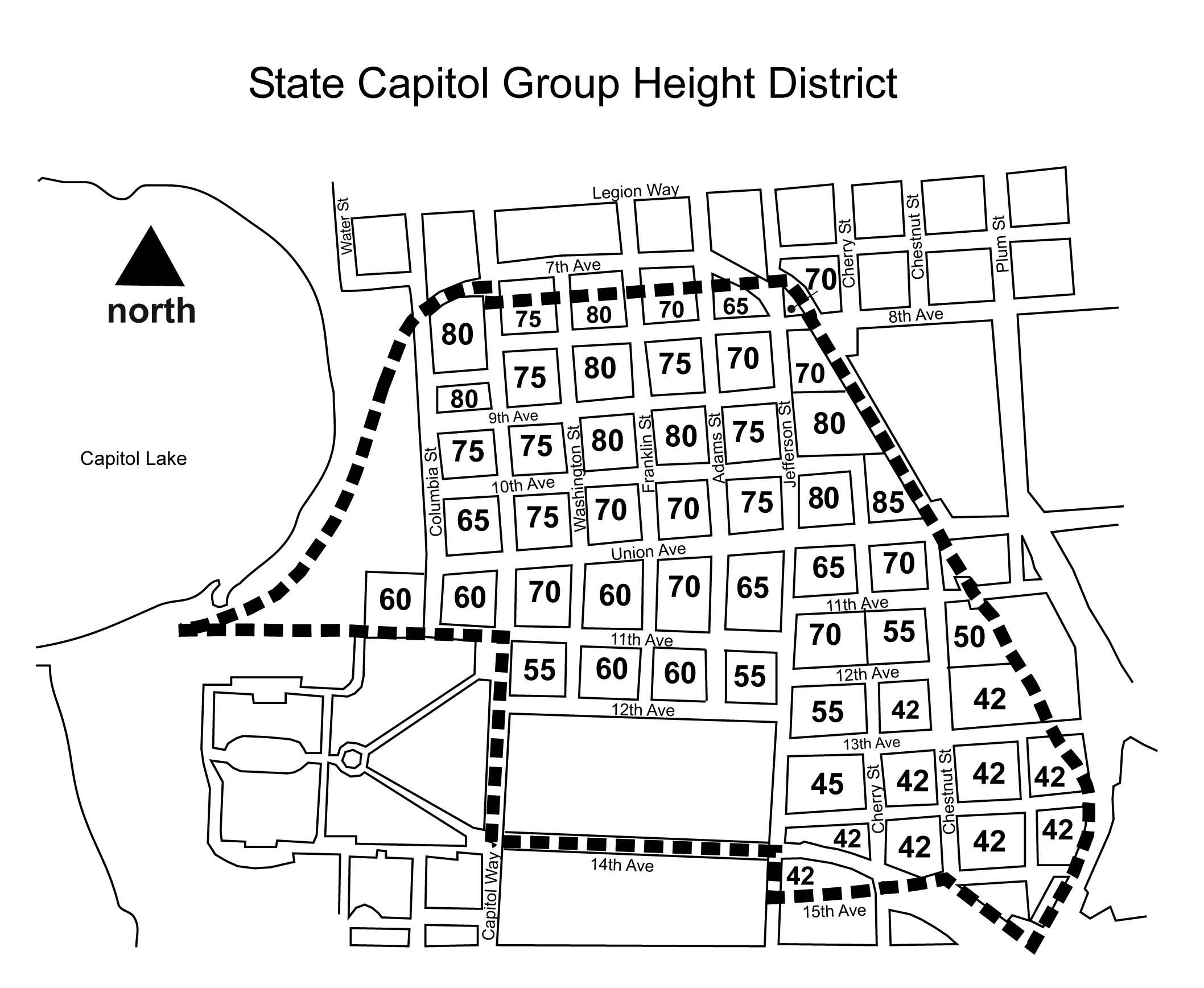
FIGURE 10-1
(Ord. 6323 §5, 2004; Ord. 5830 §15, 1998; Ord. 5517 §1, 1995).
18.10.080 Sylvester Park height district
A. Properties around Sylvester Park. Proposed development on all properties directly across Seventh Avenue from Sylvester Park shall be limited in height as follows, so that such development will not block sunlight reaching Sylvester Park between the hours of 10:00 a.m. and 2:00 p.m.:
1. This regulation applies to the area bounded by:
a. Seventh Avenue on the north,
b. Washington Street on the east,
c. The alley between Seventh Avenue and Eighth Avenue (Alley) on the south, and
d. Capitol Way on the west.
2. The height limit at the southerly right-of-way line for Seventh Avenue is thirty-five (35) feet.
3. The height limit at the northerly right-of-way line for the Alley is ninety-five (95) feet, provided, that the height of the building may not exceed seventy-five (75) feet unless the requirements of Subsection 18.06.100(C)(6)(b) (Bonus for Residential Development) are met.
4. The height limit for points between Seventh Avenue and the Alley shall be described by a plane that slopes upward in a southerly direction between the points described in (b) and (c) above. The slope of this plane is approximately fifty-four (54) percent, or twenty-eight (28) degrees. See Figure 10-2.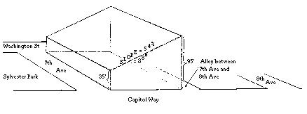
FIGURE 10-2
5. Buildings may use sloping rooflines, upper story step backs, or other techniques to ensure that no part of the building extends above the plane described in paragraph (4) above.
(Ord. 5830 §14, 1998)