


Chapter 18.30
LAND USE DESIGNATIONS
Sections:
Article I. Activities and Uses
18.30.010 Land use designations.
18.30.030 Land use table – Activity center land use designations.
18.30.040 Land use table – Rural, resource, and special land use designations.
18.30.050 Land use regulations – General provisions.
18.30.051 Archaeological and historical site protection.
18.30.052 Right to farm and forestry provisions.
18.30.053 Development permits and resource lands.
18.30.055 Siting and permitting of essential public facilities (EPFs).
18.30.060 Master planned resorts – Special provisions.
18.30.070 Rural, resource, and special lands – Special provisions.
Article II. Recodified
Article III. Recodified
Article IV. Subarea Plans, Interim Controls and Development Standards
18.30.195 Activity center plans.
18.30.200 Interim controls in village and hamlet activity centers (Westsound and Doe Bay).
18.30.220 Land use standards in residential activity centers.
18.30.245 Olga Hamlet Plan – Categories of uses.
18.30.246 Olga Hamlet Plan – Design standards.
18.30.247 Olga Hamlet Plan – Density bonus for affordable housing.
Article V. Deer Harbor Hamlet Plan
18.30.250 Deer Harbor plan review committee.
18.30.260 Commercial zoning requirements.
18.30.270 Deer Harbor community center overlay district.
18.30.280 Community center development standards.
18.30.290 Land use designations.
18.30.300 Residential bonus density district.
18.30.310 Permitted land uses.
18.30.320 Development standards.
18.30.330 Expansion of existing uses.
18.30.360 Resource land buffer.
18.30.370 Outdoor storage in industrial designations.
Article VI. Orcas Village Activity Center
18.30.390 Relationship to shoreline master program.
18.30.420 Land use designations.
18.30.430 Allowable uses and land use permit requirements.
18.30.440 Development standards.
Article VII. Country Corner Island Center Plan
18.30.450 Country Corner island center plan.
18.30.452 Development standards.
18.30.453 Building height measurement.
Article VIII. Eastsound Subarea Plan
18.30.460 Eastsound subarea land use regulations.
18.30.461 Allowed commercial uses by Eastsound land use district.
18.30.462 Allowed industrial uses by Eastsound land use district.
18.30.463 Allowed institutional uses by Eastsound land use district.
18.30.464 Allowed recreational uses by Eastsound land use district.
18.30.465 Allowed residential uses by Eastsound land use district.
18.30.466 Allowed transportation uses by Eastsound land use district.
18.30.467 Allowed utilities uses by Eastsound land use district.
18.30.468 Allowed agricultural uses by Eastsound land use district.
18.30.470 Eastsound village commercial district.
18.30.480 Tax parcels regulated by Eastsound waterfront access plan.
18.30.490 Village residential/institutional district.
18.30.500 Service and light industrial district.
18.30.510 Eastsound residential districts.
18.30.520 Service park district.
18.30.530 Eastsound marina district.
18.30.540 Eastsound airport district.
18.30.550 Eastsound country corner commercial.
18.30.560 Eastsound rural residential.
18.30.580 Eastsound natural district.
18.30.590 Conservancy overlay.
18.30.610 Eastsound urban growth area.
18.30.620 General development standards.
18.30.650 Informational kiosks and mobile or semi-mobile structures.
18.30.680 Standards for new and substantially altered development.
18.30.700 Street development standards.
Article IX. Lopez Village Subarea Plan
18.30.710 Applicability of this article.
18.30.720 Lopez Village planning review committee.
18.30.730 Lopez Village urban growth area densities, and density bonuses.
18.30.740 Lopez Village urban growth area resource buffer.
18.30.750 Allowed and prohibited uses in Lopez Village urban growth area.
18.30.760 Lopez Village urban growth area setbacks and dimensional standards.
18.30.800 Mobile food vending units.
18.30.810 Live-work units in the village commercial designation.
18.30.850 Land uses requiring landscaping.
18.30.860 Parking lot landscaping.
18.30.870 Parking installed in the public right-of-way.
18.30.880 Landscape plantings.
18.30.900 Modifications to landscape requirements.
18.30.910 Installation of landscaping.
18.30.920 Landscaping maintenance.
18.30.930 Road and driveway standards.
18.30.940 Pedestrian circulation.
18.30.950 Parking in Lopez Village Association Plat parking entitlement area.
18.30.960 Parking requirements.
18.30.980 Bicycle parking standards.
18.30.990 Exterior construction materials.
Article I. Activities and Uses
18.30.010 Land use designations.
The San Juan County Comprehensive Plan establishes four principal land use classes for the County. Each class permits a different level of activity. The four general classes are growth areas, activity centers (which include areas of more intensive rural development and master planned resorts), rural lands, and resource lands. The individual land use categories within the classes are referred to as “designations.”
This section of the Unified Development Code provides development regulations by identifying uses and activities which may or may not be established in these classes. These classes have been developed based on:
• Natural systems and land capability;
• Existing land use patterns;
• The needs and expressed desires of the community; and
• Coordination with the Shoreline Management Act and the County Shoreline Master Program in Chapter 18.50 SJCC.
A. Growth Areas. Growth areas are urban lands, which provide for compact urban development, urban-level services, and urban levels and intensities of uses and activities. There are three growth areas: Friday Harbor, Eastsound, and Lopez Village. Land use designations for these areas are shown on the official maps.
B. Rural Activity Centers. The purpose of this land use class is to provide centers of activity in rural areas in a concentrated development pattern and allow for infill with a similar intensity of uses. Rural activity centers offer diverse employment opportunities; a variety of residential densities and housing types; and general commercial, general industrial, institutional, recreational, and community uses. This land use class includes village activity centers, hamlet activity centers, residential activity centers, and island centers, which are local areas of more intensive rural development (LAMIRDs) as provided for in RCW 36.70A.070(5)(d). This class also includes master planned resorts, which provide for urban-level recreational development and services in a rural setting and context. Following are the basic land use designations for rural activity centers, though in some cases these are superseded by designations in adopted activity center and subarea plans:
1. Village activity center (V).
a. Commercial (VC).
b. Industrial (VI).
c. Residential (VR).
2. Hamlet activity center (H).
a. Commercial (HC).
b. Industrial (HI).
c. Residential (HR).
3. Residential activity center (RAC).
4. Island center (IC).
5. Master planned resort (MPR).
C. Rural Lands. This land use class includes five designations:
1. Rural general use (RGU).
2. Rural residential (RR).
3. Rural farm-forest (RFF).
4. Rural industrial (RI).
5. Rural commercial (RC).
D. Resource Lands. This land use class includes three designations:
1. Agricultural resource (AG).
2. Forest resource (FOR).
3. Mineral resource lands (MRL) overlay (see SJCC 18.35.005).
E. Special Designations. The purpose of this rural land use subclass is to protect, conserve, and manage existing natural conditions, resources, and valuable historic, cultural, educational, or scientific research areas and to preserve indigenous plant and animal species and ecosystems in a natural state for the benefit of existing and future generations without precluding compatible human uses. This land use class includes two designations:
1. Conservancy (C);
2. Natural (N). (Ord. 25-2012 § 5; Ord. 11-2000 § 4; Ord. 2-1998 Exh. B § 3.1)
18.30.020 Land use regulations – Allowable and prohibited uses by designation and allowable residential densities.
The land use regulations which follow implement the Comprehensive Plan. They are broken down into broad categories which should include almost any type of land use that might be proposed. The use regulations establish standard procedures for all new development.
A. Categories of Allowable Use. Land uses allowed under this code are divided into five categories, as identified in Tables 18.30.030 and 18.30.040.
1. Yes, uses allowed outright (i.e., without a project permit) subject to the applicable development standards (Chapter 18.60 SJCC); if a building or other construction permit is required, this use is subject to administrative consistency review; see also SJCC 18.80.070;
2. Provisional use (a project permit) is allowed subject to the applicable development standards (Chapter 18.60 SJCC) and performance standards unique to the proposed use (Chapter 18.40 SJCC; see also SJCC 18.80.080), are designated by “P”;
3. Provisional/Conditional Use. After review of SJCC 18.80.090 and Table 8.2, the administrator will determine whether a provisional or conditional use permit will be required;
4. Conditional use (a project permit) is allowed subject to public notice and permit hearing procedure; see SJCC 18.80.100;
5. P.A. (Plan Amendment). New uses, or changes in the locations of uses in a master planned resort activity center which require an amendment to the master plan (see SJCC 18.30.060, 18.60.190, and 18.90.060).
B. Prohibited Uses. Uses designated with an “N” (=No) are not allowed in the applicable land use designation.
C. Multiple Designations. Some properties or developments may be subject to the regulations for two or more applicable land use designations, shoreline designations, or overlay districts.
D. Allowable Residential Density.
1. The maximum allowable residential density for all parcels is shown on the official maps of the San Juan County Comprehensive Plan. In determining the maximum number of allowable parcels or dwelling units, only whole numbers may be used. Fractional density units are not parcels and may not be combined across density designation or parcel boundaries to create a whole density unit.
2. Residential densities shown on the official maps of the Comprehensive Plan apply to both the areas subject to the jurisdiction of the Shoreline Master Program and the upland areas, except where shoreline regulations specify a different density.
3. The maximum allowable density reflects the general intent of the Comprehensive Plan and should be allowed unless maximum density would exceed site capabilities or unless it would thwart other applicable County land use regulations. If specific site considerations dictate a lower density than that shown on the official maps, the County shall have authority to impose a lower density. The approved density shall be determined on a case-by-case basis and shall be based on considerations of topography, protection of natural resources and systems, and the intent and policies of the Shoreline Management Act, the State Environmental Policy Act, the Comprehensive Plan, this code, and the Shoreline Master Program.
The allowed density may be reduced below the maximum if SEPA analysis or other evaluation of the site or area-wide conditions demonstrates that adverse effects of development at the maximum density can be mitigated or avoided by a reduction to the approved density, and no appropriate alternative means of mitigation is available.
4. The residential densities specified on the official maps shall not constitute and shall not be construed as minimum parcel sizes. Minimum parcel sizes may be set forth elsewhere in this code or in a subarea plan.
5. Repealed by Ord. 7-2005.
6. Land division is prohibited in upland natural designations and in natural shoreline designations.
7. Conservancy Lands (C).
a. Where no numerical density designation is assigned on the official maps a maximum allowable density of one dwelling unit per five acres shall apply.
b. On publicly owned conservancy lands, the maximum allowable residential density is one dwelling unit per parcel, except for housing for employees (not to exceed that necessary for land or park management), or for housing associated with an existing public higher educational facility.
8. For all rural (except activity centers), resource, or conservancy designations, and for all shoreline areas, land division shall be subject to the conservation design provisions in SJCC 18.70.060 (B)(10).
9. Lopez Village Urban Growth Area. The maximum densities for all designations shall be as specified in SJCC 18.30.210.
10. Maximum allowable residential densities for planned unit developments in urban growth areas and residential activity centers shall be determined as provided in SJCC 16.55.240, 18.30.210, 18.30.220 and 18.60.220.
11. Maximum residential densities in master planned resorts are determined as provided in SJCC 18.30.060(B).
12. Regulations and maximum residential densities within the unincorporated portion of the Friday Harbor urban growth area.
a. In Harborview Place, the town of Friday Harbor regulations for the single-family land use designation and a maximum allowable residential density of four dwelling units per acre shall apply.
b. In other areas, County land use designations and densities shall apply.
13. Exception for Rural Residential Cluster Development. Land developed under the provisions of SJCC 18.60.230, Rural residential cluster development, shall be subject to the density provisions of that section.
E. Development Standards and Use Limitations. All uses are subject to certain bulk and dimensional standards, such as setbacks and off-street parking requirements. These standards are specified in Chapter 18.60 SJCC.
F. Criteria for Site-Specific Redesignations and Master Planned Resort Approval. The criteria for decisionmaking on these actions are specified in Chapter 18.90 SJCC.
G. Application, Notice, and Appeal Requirements. The requirements to file an application, the administrative processes for handling the application, and appeal procedures, are specified in Chapter 18.80 SJCC. (Ord. 25-2012 § 6; Ord. 7-2005 § 3; Ord. 14-2000 § 7(ZZ); Ord. 11-2000 § 4; Ord. 2-1998 Exh. B § 3.2)
* See SJCC 18.30.245 through 18.30.247 for provisions on density bonuses in Olga Hamlet.
18.30.030 Land use table – Activity center land use designations.
|
How to Use This Table Table 18.30.030 displays the classification of uses for activity center land use designations. The allowability and classification of uses as represented in the tables are further modified by the following: • The location may have a multiple designation; this would be true if the Shoreline Master Program, a subarea plan, or an overlay district applied to the location. Note that designations within the shorelines jurisdiction use some of the same names as the uplands land use designations but allowable uses may differ substantially between the uplands and shorelines designations. The Shoreline Master Program (SMP) should be consulted if the location of interest is subject to the SMP jurisdiction. See also notes 1 – 3 to this table. • All regulations in this code apply to the uses in these tables. To determine whether a particular use or activity can occur in a particular land use designation and location, all relevant regulations must also be consulted in addition to this table. Categories of uses: Y = Uses allowed outright (i.e., without a project permit), subject to the applicable development standards (Chapter 18.60 SJCC); if a building or other construction permit is required, this use is subject to administrative consistency review; see SJCC 18.80.070. P = Provisional use (a project permit), subject to administrative consistency review for compliance with Chapter 18.60 SJCC, Development Standards, and Chapter 18.40 SJCC, Performance and Use-Specific Standards; see SJCC 18.80.080. P/C = After review of SJCC 18.80.090 and Table 8.2, the administrator will determine whether a provisional or conditional use permit will be required. C = Conditional use, subject to public notice and permit hearing procedure; see SJCC 18.80.100. P.A. = Plan Amendment. The use requires an amendment to an adopted master plan; see SJCC 18.30.060 and 18.90.060. N = Prohibited use. Basic activity center land use designations: VC = Village Commercial HC = Hamlet Commercial IC = Island Center VI = Village Industrial HI = Hamlet Industrial MPR = Master Planned Resort VR = Village Residential HR = Hamlet Residential Residential Activity Center = Rural Residential, Table 18.30.040 (SJCC 18.30.220(C)(2)) Also see designations and associated regulations for Eastsound, Olga Hamlet, Orcas Village, Deer Harbor and Country Corner Island Center (LAMIRD). |
|
Land Uses |
Classification of Uses by Land Use Designation |
|||||||
|---|---|---|---|---|---|---|---|---|
|
Village |
Hamlet(15) |
Island Center |
Master Planned Resort |
|||||
|
VC |
VI |
VR |
HC |
HI |
HR |
IC |
MPR(5,6) |
|
|
Commercial Uses |
||||||||
|
Animal shelters and kennels |
P |
C |
N |
C |
C |
N |
C |
P.A. |
|
Automotive fuel, service, and repair stations |
P |
P |
N |
P |
P |
N |
P |
P.A. |
|
Bed and breakfast inn |
P |
N |
C |
P |
N |
C |
N |
P/C |
|
Bed and breakfast residence |
P |
N |
P |
P |
N |
P |
P |
P |
|
Camping facilities |
P |
N |
N |
C |
N |
N |
N |
P.A. |
|
Day care with 1 – 6 children |
P |
P |
P |
P |
P |
P |
P |
P |
|
Day care with 7+ children |
P |
C |
P |
P |
C |
P |
P |
P/C |
|
Drinking establishment |
Y |
N |
N |
Y |
N |
N |
N |
P/C |
|
Eating establishment |
Y |
N |
N |
Y |
N |
N |
N |
P/C |
|
Hotel/Motel |
Y |
N |
N |
C |
N |
N |
N |
P.A. |
|
Indoor entertainment facility |
Y |
P/C |
N |
C |
C |
N |
N |
P/C |
|
Nursing homes |
P |
N |
N |
N |
N |
N |
N |
P.A. |
|
Personal and professional services |
Y |
N |
N |
Y |
N |
N |
N |
P/C |
|
Personal wireless service facilities, co-located on an existing, permitted stand-alone tower, or mounted to the surface of an existing structure |
P |
P |
C(10) |
P |
P |
C(10) |
P |
P.A. (P/C where allowed) |
|
Personal wireless service facilities mounted on a building which meets the height standards of the land use designation, or facilities camouflaged or disguised as an allowable exemption to the height standard |
P |
P |
C |
P |
P |
C |
P |
P.A. (P/C where allowed) |
|
Personal wireless service facilities, other |
C |
C |
N |
C |
C |
N |
C |
P.A. (C where allowed) |
|
Residential care facilities with up to 8 persons |
P |
N |
P |
P |
N |
P |
P |
P.A. |
|
Residential care facilities with 9 – 15 persons |
P |
N |
C |
P |
N |
C |
P |
P.A. |
|
Resorts and camps, new |
P |
N |
N |
C |
N |
N |
N |
See Note 5 |
|
Commercial Uses |
||||||||
|
Existing resorts and camps, expansion of existing uses without increase to scope or scale |
P |
P |
P |
P |
P |
P |
P |
See Note 5 |
|
Existing resorts and camps, increase in scope or scale of facilities or services |
P/C |
P/C |
P/C |
P/C |
P/C |
P/C |
P/C |
See Note 5 |
|
Retail sales and services |
P |
P/C |
N |
P |
N |
N |
P |
P/C |
|
Warehouse, mini-storage, and moving storage facilities |
N |
P |
N |
N |
P/C |
N |
P |
P.A. |
|
Unnamed commercial uses |
P/C |
P/C |
N |
P/C |
P/C |
N |
P/C |
P/C |
|
Industrial Uses |
||||||||
|
Bulk fuel storage facilities |
N |
C |
N |
N |
C |
N |
P/C |
P.A. |
|
Concrete and concrete batch plants |
N |
C |
N |
N |
N |
N |
N |
P.A. |
|
Construction yards |
N |
P |
N |
N |
P/C |
N |
P |
P.A. |
|
Feedlots |
N |
N |
N |
N |
N |
N |
N |
P.A. |
|
Garbage and solid waste transfer stations |
N |
P |
N |
N |
C |
N |
P/C |
P.A. |
|
Heavy equipment rental services |
N |
C |
N |
N |
N |
N |
P |
P.A. |
|
Heavy industrial |
N |
C |
N |
N |
N |
N |
N |
P.A. |
|
Light industrial |
N |
P |
N |
N |
P/C |
N |
P/C |
P.A. |
|
Light manufacturing |
C |
P |
N |
N |
P/C |
N |
P/C |
P.A. |
|
Lumber mills, stationary |
N |
N |
N |
N |
N |
N |
C |
P.A. |
|
Marijuana production and processing, Tiers 1 and 2(13, 14) |
N |
C |
N |
N |
C |
N |
C |
N |
|
Marijuana production and processing, Tier 3 |
N |
N |
N |
N |
N |
N |
N |
N |
|
Mining and mineral extraction activities |
N |
C |
N |
N |
N |
N |
N |
P.A. |
|
Outdoor storage yards |
N |
P |
N |
N |
P/C |
N |
P |
P.A. |
|
Reclamation of mineral extraction sites |
P/C |
P/C |
P/C |
P/C |
P/C |
P/C |
P/C |
P.A. |
|
Recycling collection/processing |
P/C |
P/C |
N |
P/C |
P/C |
N |
P/C |
P.A. |
|
Recycling collection |
P |
P |
P/C |
P |
P |
P/C |
P |
Y |
|
Resource processing accessory to extraction operations |
N |
N |
N |
N |
N |
N |
N |
P.A. |
|
Wholesale distribution outlet |
N |
Y |
N |
N |
P/C |
N |
P/C |
P.A. |
|
Wrecking and salvage yards |
N |
C |
N |
N |
N |
N |
N |
P.A. |
|
Industrial Uses |
||||||||
|
Storage and treatment of sewerage, sludge and septage – lagoon systems |
N |
N |
N |
N |
N |
N |
N |
P.A. |
|
Unnamed industrial uses |
P/C |
P/C |
N |
P/C |
N |
N |
P/C |
P.A. |
|
Institutional Uses |
||||||||
|
College or technical school/adult education facility |
P |
P/C |
N |
P/C |
P/C |
N |
N |
P.A. |
|
Community club or community organization assembly facility |
P |
N |
P/C |
P |
N |
P/C |
N |
P/C |
|
Emergency services |
Y |
P/C |
N |
Y |
Y |
N |
Y |
P/C |
|
Government offices |
Y |
N |
N |
N |
N |
N |
N |
P.A. |
|
Institutional camps |
N |
N |
N |
N |
N |
N |
N |
P.A. |
|
Library |
Y |
N |
Y |
Y |
N |
Y |
N |
P/C |
|
Museum |
Y |
N |
N |
Y |
N |
N |
N |
P/C |
|
Post office |
Y |
N |
N |
Y |
N |
N |
N |
P/C |
|
Religious assembly facility |
P |
C |
C |
P/C |
C |
C |
P |
P.A. |
|
School, primary and secondary |
Y |
N |
C |
Y |
N |
C |
Y |
P.A. |
|
Unnamed institutional uses |
C |
C |
C |
C |
C |
C |
C |
P.A. |
|
Recreational Uses |
||||||||
|
Camping facilities in public parks |
P |
N |
N |
C |
N |
N |
N |
P.A. |
|
Indoor recreation facilities |
Y |
P/C |
N |
P/C |
P/C |
N |
P/C |
P/C |
|
Outdoor recreation developments |
P |
P/C |
C |
P/C |
P/C |
N |
P/C |
P/C |
|
Parks |
P |
N |
C |
P |
P |
C |
P |
P/C |
|
Playing fields |
P |
N |
P |
P |
P |
P |
P |
P/C |
|
Recreational vehicle parks |
P/C |
P/C |
N |
P/C |
N |
N |
N |
P.A. |
|
Outdoor shooting ranges |
N |
N |
N |
N |
N |
N |
N |
P.A. |
|
Unnamed recreational uses |
C |
C |
C |
C |
C |
C |
C |
P.A. |
|
Residential Uses |
||||||||
|
Cottage enterprise |
P |
P |
P |
P |
P |
P |
P |
P.A.(6) |
|
Farm worker accommodations |
P |
N |
P |
Y |
N |
P |
P |
P.A.(6) |
|
Farm stay |
P |
N |
P |
P |
N |
P |
N |
P.A.(6) |
|
Home occupation |
Y |
Y |
Y |
Y |
Y |
Y |
Y |
P.A.(6) |
|
Mobile home parks(7) |
N |
N |
P |
N |
N |
P |
N |
P.A.(6) |
|
Multifamily residential units (3+ units) |
P |
P/C |
Y |
Y |
N |
Y |
N |
P.A.(6) |
|
Residential Uses |
||||||||
|
Single-family residential (1 unit only) or accessory apartment (1 unit only) accessory to an allowable nonresidential use |
Y |
Y |
Y |
Y |
Y |
Y |
Y(9) |
P.A.(6) |
|
Single-family residential unit |
Y |
P/C |
Y |
Y |
Y |
Y |
N |
P.A.(6) |
|
Two-family residential (duplex) |
Y |
P/C |
Y |
Y |
P/C |
Y |
N |
P.A.(6) |
|
Rural residential cluster development |
N |
N |
P/C |
N |
N |
P/C |
N |
N |
|
Unnamed residential uses |
C |
C |
C |
C |
C |
C |
N |
P.A.(6) |
|
Vacation rental of residence or accessory dwelling unit |
P |
P |
C |
P |
P |
C |
P |
P.A.(6) |
|
Transportation Uses |
||||||||
|
Airfields |
N |
C |
N |
N |
N |
N |
N |
P.A. |
|
Airports |
N |
C |
N |
N |
N |
N |
N |
P.A. |
|
Airstrips |
N |
N |
N |
N |
N |
N |
N |
P.A. |
|
Hangars |
N |
P/C |
P/C |
N |
N |
N |
N |
P/C |
|
Helipads |
N |
N |
N |
N |
N |
N |
N |
P.A. |
|
Ferry terminal |
C |
C |
N |
C |
C |
N |
N |
P.A. |
|
Parking lots, commercial |
P/C |
P/C |
P/C |
P/C |
P/C |
P/C |
P/C |
P/C |
|
Parking structures |
P/C |
P/C |
N |
N |
N |
N |
N |
P/C |
|
Streets, public |
Y |
Y |
Y |
Y |
Y |
Y |
Y |
Y |
|
Trails and paths, public |
Y |
Y |
Y |
Y |
Y |
Y |
Y |
Y |
|
Unnamed transportation uses |
P/C |
P/C |
N |
P/C |
P/C |
N |
P/C |
P/C |
|
Utilities Uses |
||||||||
|
Commercial communication facilities(10) |
C |
C |
N |
C |
C |
N |
C |
P.A. (C where allowed) |
|
Commercial power-generation facilities |
C |
C |
C |
C |
C |
C |
C |
P.A. |
|
Community sewerage treatment facilities |
P/C |
P/C |
P/C |
P/C |
P/C |
P/C |
P/C |
P/C |
|
Category “A” joint use wireless facility(12) |
Y |
Y |
Y |
Y |
Y |
Y |
Y |
Y |
|
Category “B” joint use wireless facility |
P/C |
P/C |
P/C |
P/C |
P/C |
P/C |
P/C |
P/C |
|
Utilities Uses |
||||||||
|
Storage and treatment of sewerage, sludge and septage – systems other than lagoons |
C |
C |
C |
C |
C |
C |
C |
P.A. |
|
Utility distribution lines |
Y |
Y |
Y |
Y |
Y |
Y |
Y |
Y |
|
Utility facilities |
P/C |
P/C |
P/C |
P/C |
P/C |
P/C |
P/C |
P/C |
|
Utility substations |
P/C |
P/C |
P/C |
P/C |
P/C |
P/C |
P/C |
P/C |
|
Utility transmission lines |
P/C |
P/C |
P/C |
P/C |
P/C |
P/C |
P/C |
P/C |
|
Water storage tanks, community |
P/C |
P/C |
P/C |
P/C |
P/C |
P/C |
P/C |
P/C |
|
Water treatment facilities |
P/C |
P/C |
P/C |
P/C |
P/C |
P/C |
P/C |
P/C |
|
Unnamed utility uses |
P/C |
P/C |
P/C |
P/C |
P/C |
P/C |
P/C |
P/C |
|
Agricultural and Forestry Uses |
||||||||
|
Agricultural activities(11) |
Y |
Y |
Y(11) |
Y |
Y |
Y(11) |
Y |
Y |
|
Forest practices,(8) no processing |
Y |
Y |
Y |
Y |
Y |
Y |
Y |
Y |
|
Lumber mills, portable |
Y |
Y |
Y |
Y |
Y |
Y |
Y |
Y |
|
Nurseries |
Y |
N |
N |
Y |
N |
N |
Y |
P/C |
|
Small-scale slaughterhouses |
N |
Y |
N |
N |
Y |
N |
P |
P.A. |
|
Unnamed agricultural and forestry uses |
C |
C |
C |
C |
C |
C |
C |
P.A. |
Notes:
1. All uses must be consistent with the goals and policies of the land use designation in which they are proposed to occur; cf. the Land Use Element of the Comprehensive Plan. All land uses in all designations must meet the general regulations in SJCC 18.30.050 through 18.30.055 unless otherwise stated therein.
2. A land use or development proposed to be located entirely or partly within 200 feet of the ordinary high water mark of a regulated shoreline is within the jurisdiction of the Shoreline Master Program, and is subject to the applicable provisions of Section 3 of the Comprehensive Plan and of Chapter 18.50 SJCC, as well as the applicable provisions and permit requirements indicated in this table. Please refer to Chapter 18.50 SJCC for specific use regulations and regulations by shoreline environment; see also SJCC 18.80.110 for shoreline permit requirements.
3. Overlay districts provide policies and regulations in addition to those of the underlying land use designations for certain land areas and for uses that warrant specific recognition and management. For any land use or development proposed to be located entirely or partly within an overlay district, the applicable provisions of the overlay district shall prevail over any conflicting provisions of the UDC.
4. Activity center and subarea plans provide alternative and more specific policies and regulations for some areas. In case of conflict, the regulations of the activity center or subarea plan shall prevail.
5. Special provisions for uses within master planned resort activity centers are described in SJCC 18.30.060; see also SJCC 18.60.190 and 18.90.060.
6. An MPR includes short-term visitor accommodations that are associated with the recreational facilities of the resort. An MPR may also include other permanent residential uses, conference facilities, and commercial activities supporting the resort, but only if these other uses are integrated into and consistent with the on-site recreational nature of the resort. It is incumbent on the master plan or plan amendment proponent to provide the information supportive of such a determination. Also see SJCC 18.30.060, 18.60.190, and 18.90.060.
7. This row is to be used solely in the instance where a mobile home park will use additional density allotted to it through a transfer-of-development-rights (TDR) program. Otherwise, a mobile home park must proceed through and meet the requirements of the subdivision regulations of Chapter 18.70 SJCC; for a platted mobile home park the allowable uses would be indicated by the row “Single-family residential unit.”
8. Forest practices (including timber harvesting), except for Class IV General (see SJCC 18.40.120 through 18.40.180), are regulated by the Washington Department of Natural Resources.
9. One dwelling unit per parcel is allowed which must be an accessory to a commercial or industrial use and located within or attached and subordinate to the commercial or industrial structure. The unit may not include an accessory dwelling unit in addition to the main residence.
10. To minimize commercial developments in residential neighborhoods, in lands designated HR and VR, wireless facilities other than joint use wireless facilities must be accessory to a legal conforming or nonconforming structure and cannot be the primary land use.
11. Agricultural activities are allowed except for “agricultural processing, retail and visitor serving facilities for products” in VR and HR.
12. Though a project permit is not required, facilities are subject to the requirements for joint use wireless facilities found in Chapter 18.40 SJCC.
13. Marijuana production and processing must be conducted in fully enclosed and secure structures such as a stick-built building or an opaque greenhouse with rigid walls, a roof, and doors.
14. The maximum square footage used for marijuana production cannot exceed the amount licensed by the Washington State Liquor and Cannabis Board. Applicants must designate the proposed production tier and the amount of square footage of proposed plant canopy on their land use and building permit application plans. The marijuana production tiers and canopy limits are:
Tier 1: Less than 2,000 square feet;
Tier 2: Two thousand square feet up to 10,000 square feet; and
Tier 3: Ten thousand square feet up to 30,000 square feet.
15. Applies to the Deer Harbor Hamlet HI-A and HI-B designations. Marijuana production and processing facilities are prohibited in Olga Hamlet designations.
(Ord. 11-2020 § 2; Ord. 25-2012 § 7; Ord. 10-2012 § 17; Ord. 21-2002 § 4; Ord. 12-2001 § 4; Ord. 8-2001 § 1; Ord. 14-2000 § 7(AAA), (BBB); Ord. 11-2000 § 4; Ord. 2-1998 Exh. B § 3.2 (Table 3.1))
18.30.040 Land use table – Rural, resource, and special land use designations.
|
How to Use This Table Table 18.30.040 displays the classification of uses for rural, resource, and special land use designations. The allowability and classification of uses as represented in the tables are further modified by the following: • The location may have a multiple designation; this would be true if the Shoreline Master Program, a subarea plan, or an overlay district applied to the location. Note that designations within the shorelines jurisdiction use some of the same names as the uplands land use designations, but allowable uses may differ substantially between the uplands and shorelines. The Shoreline Master Program (SMP) should be consulted if the location of interest is subject to the SMP jurisdiction. See also notes 1 – 3 to this table. • All regulations in this code apply to the uses in these tables. To determine whether a particular use or activity can occur in a particular land use designation and location, all relevant regulations must also be consulted in addition to this table. Categories of uses: Y = Uses allowed outright (i.e., without a project permit), subject to the applicable development standards (Chapter 18.60 SJCC); if a building or other construction permit is required, this use is subject to administrative consistency review; see SJCC 18.80.070. P = Provisional use (a project permit), subject to administrative consistency review for compliance with Chapter 18.60 SJCC, Development Standards, and Chapter 18.40 SJCC, Performance and Use-Specific Standards; see SJCC 18.80.080. P/C = After review of SJCC 18.80.090 and Table 8.2, the administrator will determine whether a provisional or conditional use permit will be required. C = Conditional use, subject to public notice and permit hearing procedure; see SJCC 18.80.100. P.A. = Plan Amendment. The use requires an amendment to an adopted master plan; see SJCC 18.30.060 and 18.90.060. N = Prohibited use. Rural, resource, and special land use designations: RGU = Rural General Use RI = Rural Industrial FOR = Forest Resource Lands RR = Rural Residential RC = Rural Commercial C = Conservancy RFF = Rural Farm-Forest AG = Agricultural Resource Lands N = Natural Residential Activity Center = Rural Residential, Table 18.30.040 (SJCC 18.30.220(C)(2)) |
|
Land Uses |
Classification of Uses by Land Use Designation |
||||||||
|---|---|---|---|---|---|---|---|---|---|
|
Rural Designations |
Resource Lands |
Special Lands(4) |
|||||||
|
RGU |
RR |
RFF |
RI |
RC |
AG |
FOR |
C |
N |
|
|
Commercial Uses |
|||||||||
|
Animal shelters and kennels |
C |
N |
C |
N |
C |
N |
N |
N |
N |
|
Automotive fuel, service, and repair stations |
C |
N |
N |
P |
P |
N |
N |
N |
N |
|
Bed and breakfast inn |
C |
N |
C |
N |
P |
N (C if historic)(5) |
N (C if historic)(5) |
N (C if historic)(5) |
N |
|
Bed and breakfast residence |
P |
N |
P |
N |
P |
P |
P |
N (C if historic)(5) |
N |
|
Camping facilities |
C |
N |
N (C if historic)(5) |
N |
N |
N |
N |
N |
N |
|
Day care with 1 – 6 children |
P |
P |
P |
P |
P |
P |
P |
N |
N |
|
Day care with 7+ children |
C |
C |
C |
C |
P |
N |
N |
N |
N |
|
Drinking establishment |
N |
N |
N |
N |
N |
N |
N |
N |
N |
|
Eating establishment |
C |
N |
N |
N |
C |
N |
N |
N |
N |
|
Hotel/Motel |
N |
N |
N |
N |
N |
N |
N |
N |
N |
|
Indoor entertainment facility |
C |
N |
N |
N |
N |
N |
N |
N |
N |
|
Nursing homes |
N |
N |
N |
N |
N |
N |
N |
N |
N |
|
Personal and professional services |
P/C |
N |
N |
N |
N |
N |
N |
N |
N |
|
Personal wireless service facilities, co-located on an existing, permitted stand-alone tower, or mounted to the surface of an existing structure |
P |
P/C(13) |
P/C(13) |
P |
P |
P/C |
P/C |
N (Except Y at Mt. Con-stitution Sites) |
N |
|
Personal wireless service facilities mounted on a building which meets the height standards of the land use designation, or facilities disguised or camouflaged as an allowable exemption to the height standard |
P |
P/C |
P/C |
P |
P |
P/C |
P/C |
N (Except Y at Mt. Con-stitution Sites) |
N |
|
Personal wireless service facilities, other |
P/C |
N |
C(13) |
P/C |
P/C |
C(14) |
C |
N (P at Mt. Con-stitution Sites) |
N |
|
Residential care facilities with up to 8 persons |
P |
P |
P |
N |
P |
P |
P |
N |
N |
|
Commercial Uses |
|||||||||
|
Vet clinic |
C |
N |
C |
N |
P/C |
N |
N |
N |
N |
|
Residential care facilities with 9 – 15 persons |
P |
C |
C |
N |
C |
N |
N |
N |
N |
|
Resorts and camps, new |
C |
N |
N (C if historic)(5) |
N |
N (P/C if historic)(5) |
N |
N |
N |
N |
|
Resorts and camps, existing: expansion of existing uses without increase to scope or scale |
P |
P |
P |
P |
P |
P |
P |
P |
P |
|
Resorts and camps, existing: increase in scope or scale of facilities or services |
P/C |
P/C |
P/C |
P/C |
P/C |
P/C |
P/C |
N |
N |
|
Retail sales and services |
C |
N |
N |
N |
P |
N |
N |
N |
N |
|
Warehouse, mini-storage, and moving storage facilities |
C |
N |
N |
N |
N |
N |
N |
N |
N |
|
Unnamed commercial uses |
P/C |
N |
P/C |
P/C |
P/C |
N |
N |
N |
N |
|
Industrial Uses |
|||||||||
|
Bulk fuel storage facilities |
C |
N |
N |
C |
C |
N |
N |
N |
N |
|
Commercial composting |
P/C |
N |
N |
P/C |
P/C |
N |
P/C |
N |
N |
|
Concrete and concrete batch plants |
C |
N |
N |
C |
N |
N |
N |
N |
N |
|
Construction yards |
C |
N |
N |
P/C |
P/C |
N |
N |
N |
N |
|
Feedlots |
N |
N |
N |
N |
N |
N |
N |
N |
N |
|
Garbage and solid waste transfer stations |
C |
N |
N |
P/C |
P/C |
N |
N |
N |
N |
|
Heavy equipment rental services |
C |
N |
N |
P |
P |
N |
N |
N |
N |
|
Heavy industrial |
C |
N |
N |
C |
N |
N |
N |
N |
N |
|
Light industrial |
C |
N |
N |
P/C |
C |
N |
N |
N |
N |
|
Light manufacturing |
C |
N |
N |
P/C |
C |
N |
N |
N |
N |
|
Lumber mills, stationary |
C |
N |
P |
P |
P/C |
P/C |
P/C |
N |
N |
|
Marijuana production and processing, Tiers 1 and 2(15, 16, 18) |
C |
N |
C(17) |
C |
N |
C(17) |
N |
N |
N |
|
Marijuana production and processing, Tier 3 |
N |
N |
N |
N |
N |
N |
N |
N |
N |
|
Outdoor storage yards |
C |
N |
N |
P |
N |
N |
N |
N |
N |
|
Reclamation of mineral extraction sites |
P/C |
P/C |
P/C |
P/C |
P/C |
P/C |
P/C |
P/C |
P/C |
|
Recycling collection/processing |
C |
N |
N(12) |
C |
C |
N |
N |
N |
N |
|
Recycling collection |
P |
N |
N |
Y |
Y |
N |
N |
N |
N |
|
Industrial Uses |
|||||||||
|
Resource processing accessory to extraction operations |
C |
N |
N |
N (C if existing)(6) |
N |
N |
N |
N |
N |
|
Mining and mineral extraction activities |
C |
N |
N |
N (C if existing)(6) |
N |
N |
N |
N |
N |
|
Wholesale distribution outlet |
C |
N |
N |
N |
N |
N |
N |
N |
N |
|
Wrecking and salvage yards |
C |
N |
N |
P/C |
N |
N |
N |
N |
N |
|
Storage and treatment of sewerage, sludge and septage – lagoon systems |
C |
N |
N |
P |
N |
N |
N |
N |
N |
|
Unnamed industrial uses |
C |
N |
N |
C |
N |
N |
N |
N |
N |
|
Institutional Uses |
|||||||||
|
College or technical school/adult education facility |
C |
N |
N |
C |
C |
N |
N |
N (P/C at UW FHL) |
N |
|
Community club or community organization assembly facility |
C |
C |
N |
N |
P/C |
N (P/C at Port Stanley School)(11) |
N |
N |
N |
|
Emergency services |
Y |
C |
C |
Y |
Y |
C |
C |
C |
N |
|
Government offices |
Y(19)/C |
C |
C |
Y(19)/C |
Y(19)/C |
C |
C |
C |
N |
|
Institutional camps |
N |
N |
N (P/C if historic)(5) |
N |
N |
N |
N (P/C if historic)(5) |
N |
N |
|
Library |
C |
C |
N |
N |
N |
N |
N |
N |
N |
|
Museum |
C |
C |
N |
N |
C |
N (C at Port Stanley School)(11) |
N |
N |
N |
|
Post office |
N |
N |
N |
N |
N |
N |
N |
N |
N |
|
Religious assembly facility |
P/C |
P/C |
P/C |
P/C |
P/C |
C |
C |
N |
N |
|
School, primary and secondary |
C |
N |
N |
N |
C |
N |
N |
N |
N |
|
Existing school, primary and secondary |
N |
N |
Y |
N |
N |
N |
N |
N |
Y |
|
Unnamed institutional uses |
C |
N |
N |
C |
C |
N |
N |
N |
N |
|
Recreational Uses |
|||||||||
|
Camping facilities in public parks |
C |
N |
N |
N |
N |
N |
N |
C |
N |
|
Indoor recreation facilities |
C |
N |
N |
N |
C |
N |
N |
N |
N |
|
Indoor swimming pool |
C |
N |
C |
N |
C |
N |
N |
N |
N |
|
Recreational Uses |
|||||||||
|
Outdoor recreation developments |
C |
C |
C |
C |
C |
N |
N |
P/C |
C |
|
Parks |
C |
C |
C |
C |
C |
N |
C |
P/C |
C |
|
Playing fields |
C |
C |
C |
C |
C |
N |
N |
C |
N |
|
Recreational vehicle parks |
N |
N |
N |
N |
N |
N |
N |
N |
N |
|
Outdoor shooting ranges |
C |
N |
N |
C |
N |
N |
N |
N |
N |
|
Unnamed recreational uses |
C |
C |
C |
C |
C |
C |
C |
N |
N |
|
Residential Uses |
|||||||||
|
Cottage enterprise |
P |
N |
P |
P |
P |
P |
P |
P |
N |
|
Farm worker accommodations |
P |
N |
P |
P |
P |
P |
P |
N |
N |
|
Farm stay |
P |
N |
P |
N |
N |
P |
P |
N |
N |
|
Home occupation |
Y |
Y |
Y |
Y |
Y |
Y |
Y |
Y |
Y |
|
Mobile home parks(7) |
N |
N |
N |
N |
N |
N |
N |
N |
N |
|
Multifamily residential units (3+ units) |
N |
N |
P/C |
N |
N |
N |
N |
N |
N |
|
Single-family residential (1 unit only) or accessory apartment (1 unit only), accessory to an allowable nonresidential use |
P |
N |
P |
P(9) |
P(9) |
P |
P |
N |
N |
|
Single-family residential unit |
Y |
Y |
Y |
N |
N |
Y |
Y |
Y |
Y |
|
Two-family residential (duplex) |
N |
N |
Y |
N |
N |
Y |
Y |
N |
N |
|
Rural residential cluster development |
N |
P/C |
P/C |
N |
N |
N |
N |
N |
N |
|
Unnamed residential uses |
C |
C |
C |
N |
N |
C |
C |
N |
N |
|
Vacation rental of residence or accessory dwelling unit |
P |
C |
P |
P |
P |
N |
N |
N |
N |
|
Transportation Uses |
|||||||||
|
Airfields |
C |
N |
N |
N |
N |
N |
N |
N |
N |
|
Airports |
C |
N |
N |
N |
N |
N |
N |
N |
N |
|
Airstrips |
C |
N |
N |
N |
N |
N |
N |
N |
N |
|
Hangars |
P |
P |
P |
N |
N |
N |
N |
N |
N |
|
Helipads |
N |
N |
N |
N |
N |
N |
N |
N |
N |
|
Ferry terminal |
C |
N |
N |
C |
C |
N |
N |
N |
N |
|
Parking lots, commercial |
N |
N |
N |
N |
N |
N |
N |
N |
N |
|
Parking structures |
N |
N |
N |
N |
N |
N |
N |
N |
N |
|
Streets, public |
Y |
Y |
Y |
Y |
Y |
Y |
Y |
C |
C |
|
Trails and paths, public |
Y |
Y |
Y |
Y |
Y |
Y |
Y |
C |
C |
|
Unnamed transportation uses |
P/C |
P/C |
P/C |
P/C |
P/C |
C |
C |
C |
C |
|
Utilities Uses |
|||||||||
|
Commercial communication facilities |
N |
N |
N |
P |
N |
N |
N |
N (C at Mt. Con-stitution Sites) |
N |
|
Commercial power-generation facilities |
C |
N |
N |
P/C |
P/C |
C |
C |
N |
N |
|
Community sewerage treatment facilities |
N |
N |
N |
N |
N |
N |
N |
N |
N |
|
Category “A” joint use wireless facility(10) |
Y |
Y |
Y |
Y |
Y |
Y |
Y |
Y |
Y |
|
Category “B” joint use wireless facility |
P/C |
P/C |
P/C |
P/C |
P/C |
P/C |
P/C |
P/C |
P/C |
|
Storage and treatment of sewerage, sludge and septage systems other than lagoons |
C |
C |
C |
C |
C |
C |
C |
N |
N |
|
Utility distribution lines |
P |
P |
P |
P |
P |
P/C |
P/C |
P/C |
P/C |
|
Utility facilities |
P/C |
P/C |
P/C |
P/C |
P/C |
P/C |
P/C |
P/C |
P/C |
|
Utility substations |
P/C |
P/C |
P/C |
P/C |
P/C |
P/C |
P/C |
P/C |
P/C |
|
Utility transmission lines |
P/C |
P/C |
P/C |
P/C |
P/C |
P/C |
P/C |
P/C |
P/C |
|
Water storage tanks, community |
P/C |
P/C |
P/C |
P/C |
P/C |
P/C |
P/C |
P/C |
C |
|
Water treatment facilities |
P/C |
P/C |
P/C |
P/C |
P/C |
P/C |
P/C |
P/C |
C |
|
Unnamed utility uses |
P/C |
P/C |
P/C |
P/C |
P/C |
P/C |
P/C |
C |
C |
|
Agricultural and Forestry Uses |
|||||||||
|
Agricultural activities |
Y |
Y |
Y |
Y |
Y |
Y |
Y |
Y |
N |
|
Forest practices, no processing(8) |
Y |
Y |
Y |
Y |
Y |
Y |
Y |
Y |
N |
|
Lumber mills, portable |
Y |
Y |
Y |
Y |
Y |
Y |
Y |
P/C |
N |
|
Nurseries |
Y |
N |
Y |
Y |
Y |
Y |
Y |
N |
N |
|
Small-scale slaughterhouses |
P |
N |
P |
Y |
Y |
P |
P |
N |
N |
|
Unnamed agricultural and forestry uses |
C |
C |
C |
C |
C |
C |
C |
N |
N |
Notes:
1. All uses must be consistent with the goals and policies of the land use designation in which they are proposed to occur; cf. the Land Use Element of the Comprehensive Plan. All land uses in all designations must meet the general regulations in SJCC 18.30.050 through 18.30.055 unless otherwise stated therein.
2. A land use or development proposed to be located entirely or partly within 200 feet of the ordinary high water mark of a regulated shoreline is within the jurisdiction of the Shoreline Master Program, and is subject to the applicable provisions of Section 3 of the Comprehensive Plan and of Chapter 18.50 SJCC, as well as the applicable provisions and permit requirements indicated in this table. Please refer to Chapter 18.50 SJCC for specific use regulations and regulations by shoreline environment; see also SJCC 18.80.110 for shoreline permit requirements.
3. Overlay districts provide policies and regulations in addition to those of the underlying land use designations for certain land areas and for uses that warrant specific recognition and management. For any land use or development proposed to be located entirely or partly within an overlay district, the applicable provisions of the overlay district shall prevail over any conflicting provisions of the UDC.
4. Special provisions for uses within conservancy and natural land designations are described in SJCC 18.30.070.
5. “Historic”: In several isolated cases, an existing use that would be made nonconforming by this UDC is considered desirable to allow to continue and possibly to expand. Because this might be difficult or prohibited if the use were to become nonconforming, the use is labeled “historic,” and the allowable use designation is indicated. See also the definitions in Chapter 18.20 SJCC.
6. Restriction of mining and mineral extraction and related resource processing in RI shall not preclude consideration of an application for redesignation as a mineral resource lands overlay district. “Existing” means operating at the time of the adoption of this code.
7. This row is to be used solely in the instance where a mobile home park will use additional density allotted to it through a transfer-of-development-rights (TDR) program. Otherwise, a mobile home park must proceed through and meet the requirements of the subdivision regulations of Chapter 18.70 SJCC; for a platted mobile home park the allowable uses would be indicated by the row “Single-family residential unit.”
8. Forest practices (including timber harvesting), except for Class IV General (see SJCC 18.40.120 through 18.40.180), are regulated by the Washington Department of Natural Resources.
9. One dwelling unit per parcel is allowed which must be an accessory to a commercial or industrial use and located within or attached and subordinate to the commercial or industrial structure. The unit may not include an accessory dwelling unit in addition to the main residence.
10. Though a project permit is not required, these facilities are subject to the requirements for joint use wireless facilities found in Chapter 18.40 SJCC.
11. The use of the Port Stanley School for artistic, scientific, historic, museum or educational purposes or community gatherings or meetings (as provided by RCW 84.36.060) is allowed by permit.
12. Properties with existing conditional use permits for recycling centers may apply for a new conditional use permit to expand the allowable uses to include recycling collection and/or processing.
13. To minimize commercial developments in residential neighborhoods, in lands designated RR and RFF with lots of less than five acres in size, wireless facilities other than joint use wireless facilities must be permitted by the use table and accessory to a legal conforming or nonconforming structure and cannot be the primary land use.
14. In AG resource designations wireless facilities shall be located, designed and operated so as to minimize interference with agricultural uses and the open, uninterrupted, pastoral viewscapes.
15. Marijuana production is allowed in:
a. Fully enclosed and secure structures such as stick-built buildings or opaque greenhouses with rigid walls, a roof and doors;
b. Nonrigid translucent greenhouses or other structures; or
c. In ground in an area fully enclosed by a physical barrier.
16. The maximum square footage used for marijuana production cannot exceed the amount licensed by the Washington State Liquor and Cannabis Control Board. Applicants must designate the proposed production tier and amount of square footage of plant canopy on land use and building permit application plans. The marijuana production tiers and canopy limits are:
a. Tier 1: Less than 2,000 square feet;
b. Tier 2: Two thousand square feet up to 10,000 square feet; and
c. Tier 3: Ten thousand square feet up to 30,000 square feet.
17. Marijuana processing is only allowed on a parcel designated RFF or AG resources if it supports a marijuana production operation on the same parcel.
18. The following minimum lot sizes apply to marijuana production and processing operations:
a. Tier 1: One acre in the RGU and RI and three acres in the RFF and AG resource designations; and
b. Tier 2: Five acres in the RGU and RI and 10 acres in the RFF and AG resource designations.
19. Use allowed by right when in conjunction with a preexisting use.
(Ord. 2-2023 § 2; Ord. 07-2022 § 1; Ord. 11-2020 § 3; Ord. 25-2012 § 8; Ord. 10-2012 § 18; Ord. 44-2009 § 1; Ord. 15-2005 § 3; Ord. 6-2004 § 1; Ord. 21-2002 § 4; Ord. 12-2001 § 4; Ord. 8-2001 § 1; Ord. 6-2001; Ord. 14-2000 § 7(AAA); Ord. 11-2000 § 4; Ord. 2-1998 Exh. B § 3.2 (Table 3.2))
18.30.050 Land use regulations – General provisions.
The regulations in this section apply to all land uses in all designations unless stated otherwise. (Ord. 25-2012 § 9; Ord. 10-2011 § 2; Ord. 2-2010 § 3; Ord. 52-2008 § 7; Ord. 12-2001 § 4; Ord. 4-2001 § 1; Ord. 2-1998 Exh. B § 3.3)
18.30.051 Archaeological and historical site protection.
A. When an application for development is received for an area known to be archaeologically or historically significant, no action shall be taken on the application and the applicant shall not initiate any excavation or development activity until the site has been inspected by a qualified archaeologist, historian, or architect, as appropriate, designated by the director.
B. If during excavation or development of a site an area of potential archaeological significance is uncovered, all activity in the immediate vicinity shall be halted, and the director shall be notified at once.
C. The following shall be stated as a condition of approval on all development permits issued:
If during excavation or development of the site an area of potential archaeological significance is uncovered, all activity in the immediate area shall be halted, and the director shall be notified at once.
(Ord. 25-2012 § 9; Ord. 10-2011 § 2; Ord. 2-2010 § 3; Ord. 52-2008 § 7; Ord. 12-2001 § 4; Ord. 4-2001 § 1; Ord. 2-1998 Exh. B § 3.3. Formerly 18.30.050(A))
18.30.052 Right to farm and forestry provisions.
A. Applicability. Right to farm and forestry provisions apply to all resource and rural land use designations except rural residential. The provisions of this section are not to be construed to in any way modify, supersede or abridge state or County law relative to nuisances; rather, they are only to be used in the interpretation and enforcement of the provisions of this code.
B. Purpose. To provide the residents of the County proper notification of the County’s recognition and support of farming and forestry activities.
C. Nuisance. The following shall not be considered a nuisance: agricultural and forestry activities, lumber mills operating between 7:00 a.m. and 7:00 p.m., facilities, or appurtenances thereof, conducted or maintained for commercial agricultural or forestry purposes on land designated as rural general use, rural farm-forest, rural industrial, rural commercial, agricultural resource, or forest resource.
D. Disclosure. The disclosure statement in subsection (D)(2) of this section shall be used under the following circumstances and in the following manner:
1. Approval of any land division, land use, building, or development of lands designated rural general use, rural farm-forest, rural industrial, rural commercial, agricultural resource, or forest resource, and of any lands within 500 feet of lands which are designated as agricultural resource, forest resource, or mineral resource, shall be conditioned on the execution by the applicant of a statement of acknowledgment containing the disclosure statement on a form provided by the department. The executed form shall be recorded by the County auditor in the same manner as a deed. However, if disclosure conforming to the provisions of this subsection has been recorded for a prior permit, subsequent disclosures shall not be required.
2. The required disclosure statement is as follows:
San Juan County has determined that the use of real property for agricultural and forestry operations is a high priority and favored use in the county. The county will not consider to be a nuisance those inconveniences or discomforts arising from such operations, if such operations are consistent with commonly accepted best management practices in compliance with local, state, and federal laws. If your real property includes or is within 500 feet of real property designated as Rural General Use, Rural Farm Forest, Rural Industrial, Rural Commercial, Agriculture, or Forestry, you may be subject to inconveniences or discomforts arising from such farming and forestry operations, including but not limited to noise, tree removal, odors, flies, fumes, dust, smoke, the operation of farm and forestry machinery during any 24-hour period, the storage and disposal of manure, and the application of permitted fertilizers and permitted pesticides. One or more of these inconveniences may occur as a result of agricultural and forestry operations which are in conformance with existing laws and regulations.
(Ord. 25-2012 § 9; Ord. 10-2011 § 2; Ord. 2-2010 § 3; Ord. 52-2008 § 7; Ord. 12-2001 § 4; Ord. 4-2001 § 1; Ord. 2-1998 Exh. B § 3.3. Formerly 18.30.050(B))
18.30.053 Development permits and resource lands.
Development permit approvals for the use of lands adjacent to lands designated as AG and FOR resource lands, or lands with a mineral resource land overlay designation, may be conditioned to ensure that the use of such lands shall not interfere with the continued use in the accustomed manner and in accordance with best management practices of those lands designated for resource purposes. (Ord. 25-2012 § 9; Ord. 10-2011 § 2; Ord. 2-2010 § 3; Ord. 52-2008 § 7; Ord. 12-2001 § 4; Ord. 4-2001 § 1; Ord. 2-1998 Exh. B § 3.3. Formerly 18.30.050(C))
18.30.054 Overlay districts.
Overlay districts provide policies and regulations in addition to those of the underlying land use designations. The regulations for these areas are found in SJCC 18.35.005 through 18.35.150. (Ord. 25-2012 § 9; Ord. 10-2011 § 2; Ord. 2-2010 § 3; Ord. 52-2008 § 7; Ord. 12-2001 § 4; Ord. 4-2001 § 1; Ord. 2-1998 Exh. B § 3.3. Formerly 18.30.050(D))
18.30.055 Siting and permitting of essential public facilities (EPFs).
The Growth Management Act directs that no comprehensive plan or development regulation may preclude the siting of essential public facilities (RCW 36.70A.200(2)). The identification, location, and permitting of essential public facilities shall be guided by the policies of the Comprehensive Plan, including Section B, Element 2 (Land Use), Element 3 (Shoreline Master Program), and Appendix 2 (Joint Planning Policies), along with the requirements of SJCC Titles 16 and 18.
A. Proposed facilities that satisfy County development standards shall follow the standard permitting procedures. Facilities that do not meet one or more development standards may be permitted as provided in this section.
B. Determination of an Essential Public Facility. Essential public facilities are identified in both the Comprehensive Plan and the definition section of this title. Additional essential public facilities may be identified by either amendment to the Comprehensive Plan and this chapter or by submission of a request for EPF determination as follows:
1. A request for determination that a facility is an EPF shall contain a conceptual description of the facility, an explanation of the need for the facility, a preliminary development schedule, identification of any sites that are under consideration, and required fees.
2. After receiving such a request, the County council shall hold a public hearing to discuss the request. At least 45 days prior to the meeting, the department shall provide notice in the legal section of the official County newspaper, and if particular sites are under consideration, at least 45 days prior to the meeting, notice shall be mailed to all owners of property within 500 feet of the parcel boundaries of those sites.
3. Following the public hearing, the County council shall adopt a resolution as to whether the proposed facility is an EPF.
C. Siting of New EPFs. The following procedures provide a method for siting essential public facilities when there is no suitable site with a land use designation that allows the proposed use:
1. Prior to initiating the following process the applicant shall pay the associated fees.
2. The department and applicant shall identify potential sites for the proposed facility.
3. The applicant shall analyze potential sites based on consideration of the following criteria along with any factors identified by the department which are specific to the proposed type of facility:
a. Potential impacts on existing land uses, resource lands, open space, scenic resources, critical areas, and the natural and rural environment;
b. The priority for the protection of resource lands;
c. How the location will help maintain or enhance the quality or minimize the cost of the service;
d. Economic, social and environmental impacts and benefits to the public;
e. The siting criteria and recommendations provided by the joint County/town of Friday Harbor task force, if it is established (applicable only to facilities located on San Juan Island);
f. Prevention of incompatible uses adjacent to general aviation airports;
g. The extent to which design features or operational conditions can eliminate or reduce unwanted project impacts; and
h. Whether the site is capable of being redesignated to an appropriate land use designation, i.e., whether it is capable of meeting the Comprehensive Plan goals and policies for a designation that allows the proposed essential public facility.
4. The applicant shall prepare an analysis and comparison of the potential site using the criteria described above.
5. The department and applicant shall hold a public meeting to discuss the analysis and the potential sites. At least 45 days prior to the meeting, the department shall provide notice in the legal section of the official County newspaper, and at least 45 days prior to the meeting, notice shall be mailed to all owners of property within 500 feet of the parcel boundaries of the sites under consideration.
6. Following this meeting the applicant shall select the site and prepare a written request to the County council for approval of the site and authorization to apply for redesignation of the site. This request shall include a conceptual description of the facility, a conceptual site plan, an explanation of the need for the facility, an explanation of the methodology used to select the site, the analysis and comparison of sites that were considered, and an explanation of why the proposed site was selected.
7. After receiving such a request, the County council shall conduct a public hearing to accept public input. At least 45 days prior to the hearing, the County shall provide notice in the legal section of the newspaper of record, and at least 45 days prior to the hearing notice shall be mailed to all owners of property within 1,000 feet of the parcel boundaries of the proposed site.
8. If the council finds that the proposal is appropriate and in the public interest based on the above selection criteria, analysis and testimony, it shall approve the site and authorize application for redesignation.
If the request is denied, the council shall state the reasons for denial, shall identify preferred alternative sites, and shall identify actions the applicant can take to gain approval of a site.
D. Existing Nonconforming Essential Public Facilities. Where an existing essential public facility (EPF) or a proposed expansion of an existing facility is nonconforming, it may be expanded on site or in combination with an adjacent parcel or parcels provided the County council holds a public hearing and determines that any nonconformity with respect to County regulations regarding critical areas or resource lands will not be increased and that the public benefits of expanding the facility in the existing location outweigh the economic, social and environmental impacts associated with relocating the facility. After said determination, the hearing examiner is vested with the authority to consider an application for expansion according to the essential public facility conditional use permit procedures of Chapter 18.80 SJCC.
E. Where a facility is located or proposed in an appropriate land use, but cannot meet one or more of the development standards included in SJCC Title 16 or 18, the proposal may be approved with an essential public facility conditional use permit as provided in Chapter 18.80 SJCC. (Ord. 1-2020 § 2; Ord. 25-2012 § 9; Ord. 10-2011 § 2; Ord. 2-2010 § 3; Ord. 52-2008 § 7; Ord. 12-2001 § 4; Ord. 4-2001 § 1; Ord. 2-1998 Exh. B § 3.3. Formerly 18.30.050(E))
18.30.060 Master planned resorts – Special provisions.
“Master planned resort” is an activity center designation established under the Comprehensive Plan.
A. Allowable Uses.
1. Initial Determination. Allowable uses and their locations within a master planned resort are determined during the development of the master plan. The SJC planning director shall recommend such uses and any conditions for uses to be considered allowable. The BOCC then determines these uses as part of the approval of the master plan.
2. Changes in Uses. Subsequent changes in uses or in the location of allowable uses at master planned resorts are handled through amendments to the master plan.
a. Recognizing that a master planned resort may require small changes to facilities and services in response to changing customer demand or markets, some degree of flexibility for the resort is desirable. Such flexibility eliminates the need for every change to be processed as a master plan amendment. Accordingly, Table 18.30.030, Allowable and Prohibited Uses in Activity Center Land Use Designations, identifies those uses which may be allowed by the administrator without a master plan amendment after establishment of the master planned resort.
b. The list of uses in Table 18.30.030 that may be allowed after establishment of a master planned resort is only to be used for changes to the uses in an approved master plan. It is not intended to, in any way, indicate which land uses or activities are appropriate to or may be approved for any particular master planned resort.
B. Residential Densities and Uses.
1. Residential Density. A mix of urban and suburban development densities may be established within an MPR activity center but must be integrated into and support the on-site recreational nature of the resort. This is determined at the time of master plan approval.
2. Residential Density in the Vicinity of the Resort. New urban and suburban land uses and densities are prohibited outside the boundaries of the MPR activity center.
C. Self-Contained Development. All necessary supportive and accessory on-site urban-level commercial and other services should be contained within the boundaries of the MPR activity center, and such services shall be oriented to serve the MPR. However, an outside service provider (including a municipality or special purpose district) may provide sewer, water, stormwater, security, fire suppression, or emergency medical services to the resort; provided, that all costs associated with service extensions and capacity increases directly attributable to the master planned resort are fully borne by the resort. A master planned resort and service providers may enter into agreements for shared capital facilities and utilities; provided, that such facilities and utilities serve only the master planned resort or urban growth areas.
D. Master Plan Amendments. The procedures and process for adopting or amending a master plan are as provided in SJCC 18.90.060 and in the particular master plan.
E. Planned Unit Development Applications. Any new development and any new phase of development in an MPR land use designation, except as provided in SJCC 18.90.060(D)(5), requires the approval of a planned unit development as provided in SJCC 18.90.060. A phase that is consistent with the approved master plan will not require a master plan amendment. (Ord. 25-2012 § 10; Ord. 11-2000 § 4; Ord. 2-1998 Exh. B § 3.4)
18.30.070 Rural, resource, and special lands – Special provisions.
A. Agricultural and Forest Resource Lands. On all agricultural or forest resource lands (AG and FOR), the maximum area of development which is not related to agricultural or forestry uses and activities shall be limited to 20 percent of the parcel area, but not less than one acre, regardless of the assigned density. Further, in the division of a parcel by any means, the allowable area for conversion of the parent parcel to nonfarm and/or nonforestry use shall not be exceeded. This shall not apply to parcels smaller than five acres.
B. Conservancy Designations.
1. Practices for the maintenance of indigenous plants, for continuous growth of desirable tree and plant species native to the site, and for uses which do not involve physical development or alteration of property shall be allowed outright.
2. Uses which require physical development or alteration of property must protect the conservancy resource. The uses may only be approved by the decision-maker if this protection is ensured.
3. Residential Density. The maximum in allowable residential densities for conservancy parcels are as described in SJCC 18.30.020(D)(7).
4. All residential development on publicly owned conservancy lands shall require a conditional use permit.
C. Natural Designations.
1. Residential Density. One residential unit is allowed per legal lot of record. Land division is prohibited.
2. Required Permits and Use Limitations.
a. Practices for the maintenance of indigenous plants, for continuous growth of desirable tree and plant species native to the site, and for uses which do not involve physical development or alteration of property shall be allowed outright.
b. Uses which require physical development or alteration of property are prohibited unless otherwise indicated in Table 18.30.040. The natural resource must be protected, and the uses may only be approved by the decision-maker if this protection is ensured.
c. Cultural facilities shall be limited to those designed for the purpose of conserving or interpreting the natural or cultural history of the property or for the education of visitors about its natural or cultural resources. Any such facility shall be small in scale, shall leave the majority of the site undisturbed, and shall have no more than a minimal impact on the character or value of the natural area.
d. At Madrona Point on Orcas, if any provision of this section is in conflict with the terms or intent of the 1989 Agreement between the County and the Lummi Indian Tribe (executed under authority of 25 U.S.C. Section 465 and recorded under San Juan County Auditor’s File Number 90164328), the 1989 agreement shall prevail. (Ord. 25-2012 § 11; Ord. 7-2005 §§ 4, 5; Ord. 11-2000 § 4; Ord. 2-1998 Exh. B § 3.5)
Article II. Overlay Districts*
* Code reviser’s note: Article II of this chapter has been recodified to Chapter 18.35 SJCC, Article I.
Article III. Specific Overlay District Regulations*
* Code reviser’s note: Article III of this chapter has been recodified to Chapter 18.35 SJCC, Article II.
Article IV. Subarea Plans, Interim Controls and Development Standards
18.30.190 Subarea plans.
Subarea plans provide goals, policies and may provide regulations which are consistent with but more specific than the general provisions of the Comprehensive Plan and development code. They are developed to meet the needs of a particular geographic area or to manage a particular resource. Chapter 18.90 SJCC includes procedures for creating and amending subarea plans. Adopted subarea plans include:
A. The Eastsound subarea plan, Article VIII of this chapter, and any amendments thereto.
B. The Shaw Island subarea plan, Chapter 16.45 SJCC, and any amendments thereto.
C. The Waldron Island Limited Development District subarea plan, Chapter 16.36 SJCC, and any amendments thereto.
D. The Lopez Village subarea plan, and any amendments thereto.
E. The San Juan Islands Trust Lands Management Plan, adopted by the county (Ordinance No. 86-1986).
F. The San Juan County Open Space and Conservation Plan, adopted in 1991 (Ordinance No. 124-1991), and any amendments thereto. (Ord. 11-2019 § 8; Ord. 25-2012 § 18; Ord. 10-2012 § 19; Ord. 2-1998 Exh. B § 3.7)
18.30.195 Activity center plans.
Activity center plans also provide goals, policies and regulations which are consistent with but more specific than the general provisions of the Comprehensive Plan and development code. An activity center is synonymous with a “limited area of more intense development” as defined by RCW 36.70A.070(5)(d), and they are largely defined by the built environment as it existed in 1991. The Comprehensive Plan identifies five types of activity center, and 13 individual activity centers. Adopted activity center plans include:
A. Olga Hamlet plan (Ord 10-2006).
B. Deer Harbor Hamlet plan (Ord. 26-2007).
C. Orcas Village activity center (Ord 46-2008).
D. Country Corner Island center (LAMIRD). (Ord. 25-2012 § 19)
18.30.200 Interim controls in village and hamlet activity centers (Westsound and Doe Bay).
A. Purpose. To provide temporary controls for the development of certain activity centers, for which location-specific designations and standards have not yet been developed, until such designations and standards are adopted.
B. Applicability. This section shall apply to residential, commercial and industrial development within the rural activity center boundaries shown on the activity center official maps for the following: Westsound and Doe Bay.
C. Standards.
1. Building Height. Building height shall not exceed 30 feet unless more than one taller building exists in the activity center, in which case the height standards in Chapter 18.60 SJCC shall apply. Unless specified elsewhere in this section, building height shall be as determined as per height standards in SJCC 18.50.540(A)(3) for residential shoreline properties, or per SJCC 18.60.050 for nonshoreline properties.
2. Building Scale. The construction of any commercial or industrial building or buildings which exceed 5,000 square feet in gross usable area within any structure, or cumulatively on a single parcel, is prohibited. No multifamily residential building, or complex of residential buildings on a single parcel, shall include more than three dwelling units.
3. Use. Commercial and industrial uses are allowed subject to the provisions of this section and Table 18.30.030. Other uses are subject to the provisions of Table 18.30.030. No industrial use shall be established prior to the adoption of a village or hamlet industrial designation and map for the affected activity center. However, the expansion of an existing industrial use allowed by Table 18.30.030 is allowable.
4. Landscaping and Open Space. Include open or landscaped areas as listed in Table 6.1, SJCC 18.60.050, Density, Dimension, and Open Space Standards.
5. Moorage Structures. Moorage structures in the village and hamlet activity centers are regulated as per SJCC 18.50.320 and 18.50.330.
D. Density Bonus for Affordable Housing in the Bonus Density Residential District in the Doe Bay Hamlet Activity Center. The location of this bonus density district is shown on the official maps. Within this district:
1. The base allowable residential density of the bonus density district in Doe Bay hamlet shall be one dwelling unit per five acres. The maximum allowable residential density with the affordable housing bonus shall be two dwelling units per acre.
2. Dwelling units above the base density will be allowed only for a development that provides a minimum of 25 percent of the proposed residential units (base units plus bonus units) as affordable housing as specified in SJCC 18.60.260.
3. The number of dwelling units permitted in a development providing a minimum of 25 percent of the proposed residential units as affordable housing is the lesser of:
a. The number of dwelling units allowed by the base allowable residential density, plus 1.5 times the number of affordable housing units provided, rounded down to whole units; and
b. The number of dwelling units allowed by the maximum allowable residential density shown on the official maps.
E. Review. The level of application review shall be as specified in Table 18.30.030. In village and hamlet activity centers, the Residential column shall be used to determine whether a residential use is allowed and what permit level is required; for all other proposed uses, the Commercial column shall be used. Industrial uses are limited by the provisions of this section.
F. Sunset. The interim controls of this section will end for a given activity center named in subsection (B) of this section when the location-specific designations and standards are adopted by the County council. (Ord. 25-2012 § 20; Ord. 46-2008 § 7; Ord. 26-2007 § 1; Ord. 2-2005; Ord. 12-2001 § 4; Ord. 11-2000 § 4; Ord. 2-1998 Exh. B § 3.8)
18.30.210 Land use controls in Lopez Village urban growth area, the Lopez Village growth reserve area, and the Lopez marine center LAMIRD.
A. Purpose. To provide controls for development of the Lopez Village urban growth area, the Lopez Village growth reserve area and the Lopez marine center LAMIRD.
B. Article IX of this chapter contains specific development regulations and standards for all new development, and all substantial alterations within the boundaries of Lopez Village urban growth area.
C.1. The designations in Table 18.30.750, Land Use Table – Lopez Village Urban Growth Area Land Use Designations (SJCC 18.30.750) apply to the entire Lopez Village urban growth area, except as modified by SJCC 18.60.220(D) for planned unit developments.
a. Land uses are allowed subject to the provisions of this section and Table 18.30.750 (SJCC 18.30.750).
D. Land Use Controls in the Lopez Village Growth Reserve Area.
1. The Lopez Village growth reserve area must follow the land use designation standards of the rural farm forest (RFF) as listed in Table 18.30.040, Allowable and Prohibited Uses in Rural, Resource, and Special Land Use Designations, which allows a current density of one unit per five acres except that new development and associated improvements and structures shall be located on the property so that they must not preclude future potential development as a density of four units per acre or greater in the growth reserve area.
2. Land divisions must provide remainder lots that will allow an average density with the division of four units per acre or greater.
3. The following note must be on the face of the plat of all subdivisions and short subdivisions and on all deeds filed as part of an exempt division:
This land division is located within a growth reserve area. This land division has been designed in a manner to allow the future redivision to achieve an average density of four homes per acre.
E. Marine Center LAMIRD. The Lopez area marine center LAMIRD (limited area of more intense rural development) must be governed by the village commercial (VC) land use designation as listed in SJCC 18.30.030, Table 18.30.030, Allowable and Prohibited Uses in Activity Center Land Use Designations, and will allow a residential density of four dwelling units per acre. (Ord. 11-2019 § 9; Ord. 25-2012 § 21; Ord. 9-2005 § 2; Ord. 2-2001; Ord. 11-2000 § 4; Ord. 2-1998 Exh. B § 3.9)
18.30.220 Land use standards in residential activity centers.
A. Purpose. To provide standards for the development of residential activity centers.
B. Applicability. This section shall apply to development within the boundaries shown on the official maps for residential activity centers.
C. Standards.
1. Minimum parcel size is 0.5 acre (except as provided for PUD development in subsection (D) of this section).
2. Allowed Uses. The allowable and prohibited uses of the rural residential land use designations in Table 18.30.040 apply to the entire residential activity center areas. Single-family and multifamily residential accessory uses are allowed subject to the provisions of this section and Table 18.30.040.
3. Building Height. Building height shall not exceed 30 feet unless more than one taller building exists in the residential activity center, in which case the height standards of the hamlet residential designation in Table 6.1 in SJCC 18.60.050 shall apply.
4. Landscaping and Open Space. Include open or landscaped areas as listed for the hamlet residential designation in Table 6.1 in SJCC 18.60.050, except where project-specific standards are required as a condition of approval of a PUD under subsection (D) of this section and SJCC 18.60.220.
5. Water and Sewer Services.
a. Urban-level water service and fire-suppression flow may be provided in any part of these residential activity centers.
b. Sewer service may be provided to any part of the Rosario residential activity center.
D. Bonus Density District and Planned Unit Development. The locations of bonus density districts are shown on the official maps. Development may occur in the bonus density district in the following ways:
1. Development without a Planned Unit Development Application. Single-family residential development may occur without a PUD application under the following conditions:
a. Rosario Residential Activity Center.
i. The maximum allowable residential density is one dwelling unit per two acres.
ii. Minimum parcel size is 0.5 acre.
2. Development with a Planned Unit Development Application. Using the PUD procedures of SJCC 18.80.160 and meeting the requirements and standards of SJCC 18.60.220:
a. Rosario Residential Activity Center.
i. The base allowable residential density is one dwelling unit per two acres.
ii. Maximum allowable residential density for development under the affordable housing provisions and bonuses of SJCC 18.60.220 is two dwelling units per acre. (Ord. 25-2012 § 22; Ord. 14-2001 § 5; Ord. 11-2000 § 4; Ord. 2-1998 Exh. B § 3.10)
18.30.230 Residential development standards in island centers, rural industrial and rural commercial designations.
A. Purpose. To protect the limited rural areas available for commercial and industrial development from the location of incompatible residential development.
B. Applicability. This section shall apply to island center activity centers, rural industrial, and rural commercial land use designations.
C. Residential Development Standard.
1. One dwelling unit per parcel is allowed.
a. The unit must be an accessory to a commercial, institutional, or industrial use, and must be subordinate to the commercial, institutional, or industrial structure. The dwelling unit shall not be constructed prior to the establishment of the primary commercial, institutional, or industrial use, but may be constructed concurrently.
b. Notwithstanding the definition of “dwelling unit” in SJCC 18.20.040, the dwelling unit may not include an accessory dwelling unit in addition to the main residence.
2. All other new residential development is prohibited. (Ord. 2-2023 § 3; Ord. 25-2012 § 23; Ord. 21-2002 § 4; Ord. 11-2000 § 4; Ord. 2-1998 Exh. B § 3.11)
18.30.240 Village and hamlet activity center plans.
Repealed by Ord. 25-2012. (Ord. 10-2006)
18.30.245 Olga Hamlet Plan – Categories of uses.
|
Yes = |
Uses allowed outright (i.e., without a project permit), subject to the applicable development standards (Chapter 18.60 SJCC); if a building or other construction permit is required, this use is subject to administrative consistency review; see SJCC 18.80.070. |
|
Prov = |
Provisional use. Subject to administrative consistency review for compliance with Chapter 18.60 SJCC, Development Standards, and Chapter 18.40 SJCC, Performance and Use-Specific Standards, specific to the use; see SJCC 18.80.080. |
|
D = |
Discretionary use. A discretionary use subject to administrative permit approval and consistency with Chapter 18.60 SJCC, Development Standards. The administrator may require a conditional use permit based on project impacts; see SJCC 18.80.090 and Table 8.2. |
|
C = |
Conditional use. Subject to public notice and permit hearing procedure; see SJCC 18.80.100. |
|
No = |
Prohibited use. |
|
Land Use OLGA HAMLET (As defined and used in the County Unified Development Code)
|
Olga Hamlet Designation |
||
|---|---|---|---|
|
OHC |
OHCC |
HR |
|
|
Commercial |
Community |
Residential |
|
|
Commercial Uses |
|
|
|
|
Animal Shelters and Kennels |
No |
No |
No |
|
Automotive Service and Repair |
No |
No |
No |
|
Bed and Breakfast Inn |
No |
No |
No |
|
Bed and Breakfast Residence |
Prov |
Prov |
Prov (5) |
|
Camping Facilities |
No |
No |
No |
|
Day Care with 1 – 6 Children |
No |
Prov |
Prov (5) |
|
Day Care with 7+ Children |
No |
No |
No |
|
Drinking Establishment |
No |
No |
No |
|
Eating Establishment |
C |
C |
No |
|
Hotel/Motel |
No |
No |
No |
|
Indoor Entertainment Facility |
No |
No |
No |
|
Nursing Homes |
No |
No |
No |
|
Personal and Professional Services |
Yes |
C |
No |
|
Residential Care Facilities with up to 4 persons |
Prov (6) |
Prov (6) |
Prov (5), (6) |
|
Residential Care Facilities with 5 to 15 persons |
No |
No |
No |
|
Resorts and Camps, New |
No |
No |
No |
|
Retail Sales and Services |
C |
C |
No |
|
Warehouse, Mini-Storage, and Moving Storage Facilities |
C |
C |
No |
|
Unnamed Commercial Uses (8) |
No |
No |
No |
|
Industrial Uses |
|
|
|
|
Bulk Fuel Storage Facilities |
No |
No |
No |
|
Concrete and Concrete Batch Plants |
No |
No |
No |
|
Construction Yards |
No |
No |
No |
|
Feedlots |
No |
No |
No |
|
Garbage and Solid Waste Transfer Stations |
No |
No |
No |
|
Heavy Equipment Rental Services |
No |
No |
No |
|
Heavy Industrial |
No |
No |
No |
|
Light Industrial |
No |
No |
No |
|
Light Manufacturing |
No |
No |
No |
|
Lumber Mills, Stationary |
No |
No |
No |
|
Outdoor Storage Yards |
No |
No |
No |
|
Reclamation of Mineral Extraction Sites |
No |
No |
No |
|
Recycling Center |
No |
No |
No |
|
Recycling Collection Point |
No |
No |
No |
|
Resource Processing Accessory to Extraction Operations |
No |
No |
No |
|
Mining and Mineral Extraction Activities |
No |
No |
No |
|
Wholesale Distribution Outlet |
No |
No |
No |
|
Wrecking and Salvage Yards |
No |
No |
No |
|
Storage and Treatment of Sewerage, Sludge, and Septage – Lagoon Systems |
No |
No |
No |
|
Unnamed Industrial Uses |
No |
No |
No |
|
Public and Institutional Uses |
|
|
|
|
College or Technical School/Adult Education Facility |
C |
C |
No |
|
Community Club or Community Organization |
C |
C |
No |
|
Emergency Services |
C |
C |
No |
|
Government Offices |
No |
No |
No |
|
Institutional Camps |
No |
No |
No |
|
Library |
Yes |
C |
No |
|
Museum |
Yes |
Yes |
No |
|
Post Office |
Yes |
Yes |
No |
|
Religious Assembly Facility |
C |
C |
No |
|
School, Primary and Secondary |
C |
C |
No |
|
Unnamed Institutional Uses
|
No |
No |
No |
|
Recreational Uses |
|
|
|
|
Camping Facilities in Public Parks |
No |
No |
No |
|
Indoor Recreation Facilities |
No |
No |
No |
|
Outdoor Recreation Developments |
No |
No |
No |
|
Parks |
C |
C |
C |
|
Playing Fields |
No |
No |
No |
|
Recreational Vehicle Parks |
No |
No |
No |
|
Outdoor Shooting Ranges |
No |
No |
No |
|
Unnamed Recreational Uses |
No |
No |
No |
|
Residential Uses |
|
|
|
|
Cottage Enterprise |
Prov |
Prov |
D |
|
Farm Labor Accommodations for Persons Employed in Agricultural Production on the Premises |
No |
No |
No |
|
Farm Stay |
No |
No |
No |
|
Home Occupation |
Yes |
Yes |
Yes |
|
Mobile Home Parks |
No |
No |
No |
|
Multifamily Residential Units (3+ units) |
Yes |
C |
No |
|
Rural Residential Cluster Development |
No |
No |
C |
|
Single-Family Residential (1 unit only), or Accessory Apartment (1 unit only) Accessory to an Allowable Nonresidential Use |
Yes |
Yes |
Yes |
|
Single-Family Residential Unit |
Yes |
Yes |
Yes |
|
Two-Family Residential (Duplex) (9) |
Yes |
Yes |
Yes |
|
Vacation Rental of Residence or Guest House (Accessory Dwelling Unit) |
No |
No |
C (5) |
|
Unnamed Residential Uses |
No |
No |
No |
|
Transportation Uses |
|
|
|
|
Airfields |
No |
No |
No |
|
Airports |
No |
No |
No |
|
Airstrips |
No |
No |
No |
|
Hangars |
No |
No |
No |
|
Helipads |
No |
No |
No |
|
Ferry Terminal |
No |
No |
No |
|
Parking Lots, Commercial |
No |
No |
No |
|
Parking Structures |
No |
No |
No |
|
Streets, Public |
Yes (7) |
Yes (7) |
Yes (7) |
|
Trails and Paths, Public |
Yes |
Yes |
Yes |
|
Unnamed Transportation Uses |
C |
C |
C |
|
Utilities Uses |
|
|
|
|
Commercial Communication Towers |
No |
No |
No |
|
Commercial Power Generation Facilities |
No |
No |
No |
|
Community Sewerage Treatment Facilities |
No |
No |
No |
|
Storage and Treatment of Sewerage, Sludge, and Septage – Systems Other Than Lagoons |
No |
No |
No |
|
Utility Distribution Lines |
Yes |
Yes |
Yes |
|
Utility Facilities |
No |
No |
No |
|
Utility Substations |
No |
No |
No |
|
Utility Transmission Lines |
D |
D |
D |
|
Water Storage Tanks, Community |
C |
C |
C |
|
Water Treatment Facilities |
C |
C |
C |
|
Stormwater Conveyance and Treatment Facilities |
C |
C |
C |
|
Unnamed Utility Uses |
No |
No |
No |
|
Agriculture and Forestry Uses |
|
|
|
|
Agricultural Processing Retail and Visitor-Serving Facilities for Products |
No |
No |
No |
|
Agricultural Uses and Activities |
No |
No |
D |
|
Forest Practices (4), No Processing |
No |
No |
Yes |
|
Lumber Mills, Portable |
No |
No |
No |
|
Nurseries |
Yes |
C |
C |
|
Retail Sales of Agricultural Products |
Prov |
Prov |
C |
|
Small-Scale Slaughterhouses |
No |
No |
No |
|
Unnamed Agricultural and Forestry Uses |
No |
No |
No |
Notes:
1. All uses must be consistent with the purpose of the land use district in which they are proposed to occur. All land uses in all districts must meet the general regulations in SJCC 18.30.050 unless otherwise stated therein.
2. A land use or development proposed to be located entirely or partly within 200 feet of the ordinary high water mark of a regulated shoreline is within the jurisdiction of the Shoreline Master Program, and is subject to the applicable provisions of Section 3 of the Comprehensive Plan and of Chapter 18.50 SJCC as well as the applicable provisions and permit requirements indicated in this table. Please refer to Chapter 18.50 SJCC for specific use regulations and regulations by shoreline environment; see also SJCC 18.80.110 for shoreline permit requirements.
3. The assignment of allowed and prohibited uses may not directly or indirectly preclude the siting of “essential public facilities” (as designated in the Comprehensive Plan; see also the definition in SJCC 18.20.050) within the County. See SJCC 18.30.055.
4. Forest practices (including timber harvesting), except for Class IV General (see SJCC 18.40.120), are regulated by the Washington Department of Natural Resources.
5. Commercial uses in the Hamlet Residential district are allowable only as accessories to existing residential use on the same parcel.
6. Residential care facilities shall not exceed four occupants other than the operator(s).
7. The surface of Olga Road should not be widened beyond 2005 conditions except upon demonstration that the work is necessary for public safety.
8. For purposes of this plan, unnamed commercial use includes commercial moorage facilities and the commercial use of any other moorage facility.
9. Four on-site parking spaces shall be provided for duplex units and these spaces shall be identified on a site plan with submittal of a building permit application.
(Ord. 2-2018 § 3; Ord. 10-2006 Exh. A)
18.30.246 Olga Hamlet Plan – Design standards.
The following design standards are adopted in order to preserve the traditional community character of Olga. The districts in which these standards apply are mapped in Figure 4 below. 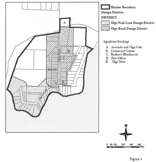
A. Structure Height Limits – Measurement Methods.
1. Where the natural grade remains unchanged the structure height shall be measured as by a plumb line from every point on the roof to the natural grade (NG). Natural grade shall mean the existing grade prior to any human modification. See Figure A below.
2. Where the natural grade has been cut at any point around the structure footprint, the structure height shall be measured as by a plumb line from every point on the roof to the altered grade elevation (AGE). See Figure B below.
3. Where fill material has been added to the natural grade, the structure height shall be measured as by a plumb line from every point on the roof to the natural grade. Artificially created grades shall be included in computing the structure height above natural grade. See Figure C below.
B. Setbacks and Height Limits for the Olga Road Historic District. The purpose of height and setback limits is to retain the feeling of small units within the open space along Olga Road, with most units having substantial setbacks and front yards. The lower height limit in front is intended in part to maximize the view of all parcels up and down Olga Road and to keep a relatively wide view corridor down Olga Road from Point Lawrence Road to Olga Park Lane.
1. Forty-seven-foot front yard setback from the Olga Road centerline.
2. Ten-foot front yard setback from other rights-of-way.
3. Sixteen-foot height limit within 47 feet to 57 feet from the Olga Road centerline.
4. Twenty-two-foot height limit on the rest of each parcel.
Combined with the 45-foot right-of-way width, these setback standards provide for a 115-foot width to the open view corridor down Olga Road.
C. Setback and Height Limits for Olga Park Lane Historic District. The purpose of the height and setback limits on Olga Park Lane is to retain the character of small structures along an intimate wooded lane. Contrasting with the character of Olga Road, Olga Park Lane is characterized by small, closely spaced structures on the water side of the road, with very little development on the land side. The natural landscape is heavily wooded, in contrast to the open lawns and with scattered remnant orchard trees and occasional large trees found along Olga Road. In order to prevent potential future land-side structures from dramatically changing this character, and to preserve the views from land-side parcels over the water-side structures, the following height and setback limits are adopted:
1. Twenty-two-foot front yard setback from the Olga Park Lane centerline.
2. Twenty-two-foot height limit from existing natural grade on water-side properties on their Olga Park Lane frontage.
3. Twenty-five-foot height limit from natural grade on other frontages and on land-side parcels.
D. Setback and Height Limits in the Remainder of Olga.
1. Ten-foot front yard setback from right-of-way.
2. Twenty-five-foot height limit from natural grade.
E. Building Floor Area and Lot Coverage. The purpose of the building floor area and lot coverage limits is to retain the appearance and feeling of small structures in open space that is the current character of Olga along Olga Road, and to prevent infill structures from substantially changing this appearance. Larger structures are permitted on larger lots. These limits apply to the entire hamlet in order to prevent unusually large structures from being introduced which would dramatically change the character of the community.
|
Lot Area: |
Permitted Floor Area of Residential Structures: |
Maximum Lot Coverage (all structures): |
|---|---|---|
|
Up to 6,000 sq. ft. |
1,500 sq. ft. |
1,500 sq. ft. |
|
6,000 – 10,000 sq. ft. |
25% of parcel area |
25% |
|
10,001 to 43,560 sq. ft. |
2,500 sq. ft. |
25% to 4,000 sq. ft. |
|
More than 1 acre |
3,000 sq. ft. + 500 sq. ft. per additional dwelling unit including accessory dwelling units |
10% |
In calculating lot coverage, the area enclosed by foundations, floors and frames of homes, garages, shops, carports and other outbuildings is considered. Roof overhang areas are not considered. The floor area of a residential structure includes the area of an attached garage.
F. Roof Pitch. The primary roof pitch for structures in the Olga Road Historic District must be gabled with a rise:run ratio of at least 5:12 and not greater than 12:12. Dormers within the primary roof pitch shall have a rise:run ratio of no less than 2:12 and be set back a minimum of two feet from the end walls and one foot from the drip edge. (Ord. 10-2006 Exh. A. Formerly 18.30.245(B))
18.30.247 Olga Hamlet Plan – Density bonus for affordable housing.
In order to provide for the potential to develop additional dwellings specifically for the purpose of providing affordable housing, up to 15 affordable housing bonus units may be developed within the boundary of Olga Hamlet.
Affordable housing bonus units may be developed on an existing parcel, or additional parcels may be created for affordable housing bonus units subject to the following limitations:
A. The maximum density on an existing parcel resulting from the addition of affordable housing density bonus units or division for affordable housing density bonus units may not exceed two dwelling units per acre. Parcels created under these provisions shall be deed restricted to prevent further division that would exceed this density within the boundary of the original parcel.
B. The maximum parcel size for a separate parcel created specifically for affordable housing density bonus units may not exceed one-quarter acre per dwelling unit.
C. Any parcel created for the purpose of constructing affordable housing density bonus units shall be subject to a restrictive use easement to San Juan County limiting the use of the parcel to affordable housing under such terms as the County may require.
D. Any parcel on which an affordable housing density bonus unit is created shall be subject to a restrictive use easement to San Juan County for that portion of the parcel on which the affordable housing unit is located and including any exterior areas designated for use as yard area or area for accessory structures for the affordable housing unit, under such terms as the County may require. (Ord. 10-2006 Exh. A. Formerly 18.30.245(C))
Article V. Deer Harbor Hamlet Plan
18.30.250 Deer Harbor plan review committee.
A. Creation. The Deer Harbor plan review committee is established under authority of this plan by the San Juan County council.
B. Composition. The Deer Harbor plan review committee shall consist of seven members, resident in Deer Harbor and its environs, who shall be appointed by the County council for terms of two years each so that terms of all members do not coincide. Terms of four members shall be for one year from the date of adoption of the ordinance codified in this article and the terms of three members shall be for a period of two years from the anniversary of the date of adoption.
C. Purpose. The purpose of the Deer Harbor plan review committee is to advise the San Juan County planning commission on land use and development matters affecting Deer Harbor. The Deer Harbor plan review committee would also be responsible for carrying out studies sufficient to enable an informed decision regarding the location of the community center and other issues of importance to the future planning efforts. In addition to the tasks noted above, the Deer Harbor plan review committee is responsible for developing architecture and building design guidelines that may be adopted at a future date.
D. Authority. The Deer Harbor plan review committee shall have authority and responsibility to:
1. Review this plan at least once every five years from the date of adoption; following such review the committee may recommend to the County council amendments designed to achieve more effectively the purposes and policies of this plan; review and amendment procedures shall be as set out in SJCC 18.90.050;
2. Review and comment on all applications for redesignation, long and short plats, and conditional use permits and variances required by this plan, and all applications for shoreline permits for development within Deer Harbor; and review and comment on all environmental determinations issued according to the State Environmental Policy Act for proposed developments in Deer Harbor;
3. Monitor applications and County permit approvals for other developments within Deer Harbor to enable effective and comprehensive review of this plan;
4. On request of the administrator or on their own initiative, make recommendations regarding the intent or meaning of any provision of this plan;
5. Fulfill the above responsibilities by action in accordance with bylaws for conduct of the Deer Harbor plan review committee adopted by the County council;
6. As the full committee or a subcommittee appointed by the chair, hold regular meetings with representatives of the community and development department and the public works department, for the exchange of information about plans for the extension of services or improvements to facilities within Deer Harbor; and
7. In order to enable the committee to fulfill its duties and to be adequately informed about pending land use applications in the subarea, the planning director will provide the committee with: (a) current summary reports of all pending land use applications; and (b) complete copies of all applications requested by Deer Harbor plan review committee.
E. Appeals. The actions of the Deer Harbor plan review committee are recommendations and therefore not subject to appeal. (Ord. 26-2007 § 4)
18.30.260 Commercial zoning requirements.
A. In order to prevent future random, unplanned and scattered mixed land uses in the hamlet, and to preserve the rural character while providing these services, all new commercial zoning must be located and confined to an area designated as the community center “overlay district” and will only be allowed as part of an approved community center planned unit development. The community center planned unit development must reflect the preferred development standards detailed in SJCC 18.30.280.
B. Establish a community center overlay district that follows Deer Harbor road between the southern edge of the Deer Harbor Inn to the northern parcel of the Resort at Deer Harbor. The community center will only be developed within this zone on parcels with frontage that are no less than one acre. Development of the community center must be accomplished through the planned unit development process of SJCC 18.80.160. (Ord. 26-2007 § 5)
18.30.270 Deer Harbor community center overlay district.
A. Purpose. To implement the policy of the Deer Harbor Hamlet plan. The Deer Harbor community center overlay district is intended to protect the public, health, safety and welfare by solely limiting the area in the Deer Harbor Hamlet where the community center planned unit development may be constructed.
B. Applicability.
1. The Deer Harbor community center overlay district shall include those parcels that front on both sides of Deer Harbor Road and will extend from the southern edge of the Deer Harbor Inn to the northern edge of the Resort at Deer Harbor (as indicated in Figure 1 of the Deer Harbor Hamlet plan) within the Deer Harbor Hamlet.
2. All new commercial land use district designations within the Deer Harbor Hamlet must be part of a planned unit development on parcels of no less than one acre that have road frontage, that reflect the preferred development standards and must occur within the Deer Harbor community center overlay district.
C. General Regulations.
1. The community center planned unit development is subject to the requirements of SJCC 18.60.120, the procedural requirements of SJCC 18.80.160 and shall reflect the preferred community center development standards.
2. The community center planned unit development is limited to one PUD on contiguous lots within the community center overlay district. (Ord. 26-2007 § 6)
18.30.280 Community center development standards.
A. Purpose. To aid the formation of the community center planned unit development that encompasses both commercial and civic uses within a unified and coherent design regime that is responsive to community needs and community values.
B. Applicability. The development standards that shall guide the community center planned unit development are not regulatory so much as advisory. When evaluating proposals for the community center planned unit development, the administrator shall consider the complete application and the consistency of the proposal with the intent and scope and scale of the development standards for the community center planned unit development.
C. General.
1. Minimum Parcel Size. The minimum size parcel is one acre.
2. Open Space.
a. Minimum of 50 percent integrated open space.
b. Open space must be connecting, rather than separated and isolated.
c. Open space includes parks, recreation areas, pedestrian walkways, buffers between the community center and adjacent uses, interior buffers, landscaped areas, patios, areas retained in natural open space, view corridors.
d. At minimum, provide pedestrian walkways throughout the community center, picnicking and public gathering areas.
e. Walkways shall be at least eight feet wide and connected with all existing and proposed pathways in the hamlet. This path must be part of the overall landscape plan, which shall provide safe separation between the paths and all structures and parking areas, except where these paths provide access to such structures and parking areas.
f. Provide 50-foot landscaped buffers between the community center boundaries and adjacent properties. Type “C” screening (see UDC, SJCC 18.60.160) shall be provided between the community center and adjacent residentially developed or designated properties.
g. Landscaped areas throughout the community center with a wide variety of trees, shrubs, and grasses. Landscaping should provide a connection between the built and natural environments and should create a softening of the built environment so that it does not dominate the area.
h. Sixty-foot setback from the center line of the existing public road.
i. No required setback between uses in the community center except as required by the International Building Code.
j. Provide view corridors at least 20 feet wide to visual points of interest.
3. Streets, Roads, and Access.
a. Right-of-way width – same as UDC, SJCC 18.60.090 and 18.60.100 (50 feet if public, 30 feet if private).
b. Roadway width – same as UDC, SJCC 18.60.090 and 18.60.100 (20 feet wide for private, not mentioned for public).
c. No individual access to public roads, must be through common road or roads from community center to public roads, except for loading and unloading.
d. Provide loading and unloading areas (see SJCC 18.60.140, Off-street loading space requirements).
4. Parking.
a. UDC standards for number of spaces per use.
b. Parking nodes throughout community center district serving all the uses in the community center rather than at individual sites.
c. Parking lot interiors landscaped (see SJCC 18.30.350).
d. No single parking area greater than 30 spaces.
e. On-street parking allowed; provided, that parking spaces are located outside of the travel way and designed to not interfere with through traffic.
5. Utilities.
a. Demonstrate adequate potable water at preliminary stage. There must be a community system capable of serving all proposed uses in community center district.
b. Construct infrastructure for water and sewer at final stage prior to development commencing (may be phased to construct additional infrastructure as development occurs).
c. Demonstrate adequate area and suitability for handling sewage. Must be community system capable of serving all proposed uses in the community center district.
d. Storm drainage per UDC, SJCC 18.60.070.
6. Built Environment.
a. Buildings to be clustered and grouped to maximize open space.
b. Buildings shall be for multiple uses unless closely clustered, then single-use buildings allowed.
c. Provide for a mix of uses, including residential as accessory to an allowed nonresidential use and/or as multifamily.
D. Application Requirements.
1. Same as SJCC 18.80.160 (Procedures for planned unit developments).
2. Type, height, location of landscaping.
3. Walkways.
4. Open spaces.
5. Drainage plan.
6. Sewer plan.
7. Water plan.
8. Site plan.
9. Topography.
10. Open space calculation.
11. Building locations and sizes.
12. Road location, right-of-way width and surface area width, access to public roads.
13. List of proposed uses.
14. Phasing over 20 years.
15. Building elevations (approximate).
16. Floor plans to the extent known.
17. Grading plan per UDC.
E. Review Process.
1. Allowed uses may locate in community center only after review and approval of planned unit development.
2. Review process with preliminary review and approval and final approval upon compliance with conditions attached to preliminary review. Conditions would likely require construction of infrastructure such as road, water, sewer, drainage, landscaping, all phasing to specific time periods noted in the approval.
F. Changes to Uses in Community Center. Should allow flexibility for changes as uses locate within the community center; provided, that applicants demonstrate compliance with the intent and scope and scale of the approved site plan. (Ord. 26-2007 § 7)
18.30.290 Land use designations.
The Deer Harbor Hamlet has four distinct land use designations: hamlet residential (HR), hamlet commercial (HC), hamlet industrial – A (HI-A) and hamlet industrial – B (HI-B).
A. Hamlet Industrial – A. Existing boat storage, haul out, repair and marine sales and service businesses alongside of the fabrication and sales of environmentally friendly products at the Deer Harbor Boat Works (TPN 260724003A) as detailed in SJCC 18.30.330 are allowable uses in the hamlet industrial designation – A; however, expansion of the current scale and scope of these existing uses is subject to a conditional permit review.
B. Hamlet Industrial – B. Existing activities occurring on the Cookston/Connor property (TPNs 260752001 and 260633013 respectively) as detailed in SJCC 18.30.330 associated with the building, logging, excavation and construction trades are allowable uses in the hamlet industrial designation – B; however, expansion of the current scale or scope of these existing uses is subject to a conditional permit review.
C. Hamlet Commercial. Existing and established businesses, such as the Resort at Deer Harbor, Deer Harbor Inn, Deer Harbor Marina and Cayou Quay Marina, are permitted in the hamlet commercial designation; however, an increase to the existing scale or scope of services is allowable only under the conditional review provisions of the UDC (see Table 18.30.310).
D. Hamlet Residential. Within hamlet residential designations, residential and limited commercial and institutional uses are permitted (see Table 18.30.310). In all areas in the Deer Harbor Hamlet with a residential density of one unit per two acres, a density bonus is available for construction of affordable housing units, up to a maximum density of one dwelling unit per half acre, as provided for in the planned unit development standards in the Unified Development Code (SJCC 18.60.220). A maximum of 25 percent of the dwelling units or up to 44 units are permitted within the boundary of the Deer Harbor Hamlet. (Ord. 25-2012 § 25; Ord. 26-2007 § 8(A), (B), (D), (E))
18.30.300 Residential bonus density district.
A. A floating zone with bonus density designations is shown on the official map of Deer Harbor Hamlet. Within the bonus density floating zone areas are those designations shown as hamlet residential 2*. The “2*” indicates areas of the hamlet where residential density is limited to one residence per two acres. The asterisk, which is appended to all such density designations, indicates that additional residential units will be permitted as a planned unit development, up to a maximum density of one unit per half acre, as a bonus for the provision of long-term affordable housing as defined in SJCC 18.60.260(D).
B. Bonus Density. The number of dwelling units permitted in a development providing a minimum of 25 percent of the proposed residential units as affordable housing is the lesser of:
1. One unit per two acres, plus 1.5 times the number of affordable housing units provided, rounded down to whole units; or
2. One unit per half acre.
3. Examples:
|
2 Acres |
Market |
Affordable |
Bonus |
Total |
|---|---|---|---|---|
|
SFR |
1 |
1 |
1.5 |
2 |
|
|
1 |
2 |
3 |
4 |
|
|
2 |
2 |
3 |
4 |
|
Duplex |
1 |
1 |
3 |
4 |
C. Bonus Unit. A “bonus unit” is defined to be any residential unit in excess of the maximum density limitation which would prevail without consideration of the bonus herein provided.
D. Limitation on Credit. No more than 50 percent of the total residential units counted as affordable housing for the purpose of obtaining a density bonus shall be for middle-income households.
E. Maximum Number of Bonus Units. No more than 25 percent of the total residential units within the hamlet shall be bonus units.
F. Minimum Standards. The project shall comply with the following minimum standards:
1. All bulk and dimensional standards in Table 18.30.320.
2. At least 20 percent of the total land area (horizontally measured) of the project shall be set aside and maintained as common open space and landscaped area. Such open space shall not include:
a. Areas set aside to meet the requirements of natural environmental features and resource values, as described below;
b. Areas devoted to or available for motor vehicle circulation or parking;
c. Individual front, rear or side yards, and other areas not available or suitable for common use by project residents or the general public.
3. Construction of the affordable residences shall occur either concurrently or before construction of the other (market rate) residences, and no certificate of occupancy shall be issued to the other (market rate) residences until certificates of occupancy have been issued to all the affordable residences.
G. Preservation and Open Space. The project shall be designed to protect and preserve natural environmental features and resource values. It shall integrate open space within the development rather than providing it as an isolated element of the project and shall use such open space to enhance the visual compatibility of the project with the surrounding neighborhood.
H. Assurance of Affordability. Qualification for the affordable housing bonus will require the filing of a PUD application. No permits shall be issued until the long-term affordability requirements as specified in SJCC 18.60.260(D) have been assured. (Ord. 25-2012 § 26; Ord. 26-2007 § 9)
18.30.310 Permitted land uses.
All development and use within the exterior boundaries of the Deer Harbor Hamlet shall conform to the table of allowed land uses set forth in Table 18.30.310.
Table 18.30.310 Allowed Land Uses in Deer Harbor Hamlet1
|
Commercial Land Uses |
||||
|---|---|---|---|---|
|
LAND USES |
HR |
HC |
HI-A |
HI-B |
|
Animal Shelters and Kennels |
N |
N |
N |
N |
|
Automotive Service and Repairs |
N |
N |
C |
N |
|
Bed and Breakfast Inn |
C |
C |
N |
N |
|
Bed and Breakfast Residence |
P |
P/C |
N |
N |
|
Camping Facilities |
N |
C |
N |
N |
|
Day Care with 1 – 6 Children |
P/C |
P/C |
N |
N |
|
Day Care with 7+ Children |
C |
C |
N |
N |
|
Drinking Establishment |
N |
P |
N |
N |
|
Eating Establishment |
N |
P |
C |
N |
|
Hotel/Motel |
C2 |
C |
N |
N |
|
Indoor Entertainment Facility Theater |
N |
C |
N |
N |
|
Category “A” Joint Use Wireless Facility4 |
Y |
Y |
Y |
Y |
|
Category “B” Joint Use Wireless Facility |
P/C |
P/C |
P/C |
P/C |
|
Nursing Homes |
N |
P/C |
N |
N |
|
Personal Wireless Service Facility, Co-Located on an Existing, Permitted Stand-Alone Tower, or Mounted to the Surface of an Existing Structure |
P/C3 |
P/C |
P/C |
N |
|
Personal Wireless Services Facility, Mounted on a Building Which Meets the Height Standard of the Land Use Designation, or a Facility Disguised or Camouflaged As an Allowable Exemption to the Height Standard |
P/C |
P/C |
P/C |
N |
|
Personal Wireless Service Facility, other3 |
C |
C |
C |
N |
|
Personal and Professional Services |
N |
Y |
N |
N |
|
Residential Care Facilities [1 – 6 persons] |
C |
P/C |
N |
N |
|
Residential Care Facilities [7 – 15 persons] |
N |
C |
N |
N |
|
Existing Resorts and Camps, Expansion of Existing Uses without Increase to Scope or Scale |
N |
C |
N |
N |
|
Existing Resorts and Camps, Increase in Scope or Scale of Facilities and Services |
N |
C |
N |
N |
|
Camps, New |
N |
N |
N |
N |
|
Resorts, New |
N |
N |
N |
N |
|
Retail Sales and Services |
N |
Y |
Y |
C |
|
Vacation Rental of Residence or ADU |
C |
C |
N |
N |
|
Warehouse, Mini-Storage, and Moving Storage Facilities |
N |
N |
C |
C |
|
Auto Fuel Pumps |
N |
C |
N |
N |
|
Unnamed Commercial Uses |
N |
C |
C |
C |
1 All permitted land uses are subject to the performance and use-specific standards in Chapter 18.40 SJCC. For the purposes of this table, unnamed commercial uses include marinas and associated uses.
2 Only allowable on parcels of 30 acres or more.
3 To minimize commercial developments in residential neighborhoods, in lands designated HR wireless facilities other than joint use wireless facilities must be accessory to a legal conforming or nonconforming structure, and cannot be a primary land use.
4 Though a project permit is not required, these facilities are subject to the requirements for joint use wireless facilities found in Chapter 18.40 SJCC.
|
Industrial Land Uses |
||||
|---|---|---|---|---|
|
LAND USES |
HR |
HC |
HI-A |
HI-B |
|
Bulk Fuel Storage |
N |
N |
C |
C |
|
Concrete and Concrete Batch Plants |
N |
N |
N |
N |
|
Construction Yard |
N |
N |
C |
C |
|
Feedlots |
N |
N |
N |
N |
|
Garbage and Solid Waste Transfer Stations |
N |
N |
N |
N |
|
Heavy Equipment Rental Services (Incidental to Nonrental Primary Use of Equipment) |
N |
N |
N |
C |
|
Heavy Industrial |
N |
N |
N |
N |
|
Light Industrial5 |
N |
N |
C |
C |
|
Light Manufacturing5 |
N |
N |
C |
C |
|
Lumber Mills, Stationary |
N |
N |
N |
N |
|
Outdoor Storage Yards |
N |
N |
P/C |
P/C |
|
Recycling Center |
N |
N |
N |
N |
|
Recycling Collection Point |
N |
N |
C |
N |
|
Resource Processing Accessory to Extraction Operations |
N |
N |
N |
N |
|
Mining and Mineral Extraction Activities |
N |
N |
N |
N |
|
Reclamation of Mineral Extraction Sites |
N |
N |
N |
N |
|
Wholesale Distribution Outlets5 |
N |
N |
C |
C |
|
Wrecking and Salvage Yards (Boat) |
N |
N |
C |
N |
|
Storage and Treatment of Sewerage, Sludge, and Septage – Lagoon Systems |
N |
N |
N |
N |
|
Unnamed Industrial Uses |
N |
N |
C |
C |
5 Subject to low impact provisions of Table 8.2 of Chapter 18.80 SJCC.
|
Institutional Land Uses |
||||
|---|---|---|---|---|
|
LAND USES |
HR |
HC |
HI-A |
HI-B |
|
College |
N |
N |
N |
N |
|
Community Club or Community Organization Assembly Facility |
C |
P/C |
N |
N |
|
Emergency Services |
C |
C |
C |
C |
|
Environmental, Agricultural, Marine, Forestry, Aquacultural Research and Education Facilities |
C |
P/C |
C |
N |
|
Government Offices |
N |
C |
N |
N |
|
Institutional Camps |
N |
N |
N |
N |
|
Library |
N |
P/C |
N |
N |
|
Museum |
C |
P/C |
C |
N |
|
Post Office |
C6 |
C |
N |
N |
|
Religious Assembly Facility |
N |
C |
N |
N |
|
School, Primary and Secondary |
C |
C |
N |
N |
|
Technical School/Adult Education Facility |
N |
C |
C |
C |
|
Unnamed Institutional Uses |
C |
C |
C |
C |
6 At least one part of the property must be located within 100 feet of either side of Deer Harbor Road or within 100 feet of Channel Road between Deer Harbor Road and the Bridge. Residential development standards shall apply.
|
Recreational Land Uses |
||||
|---|---|---|---|---|
|
LAND USES |
HR |
HC |
HI-A |
HI-B |
|
Camping Facilities in Public Parks |
N |
N |
N |
N |
|
Indoor Recreation Facilities |
N |
C |
N |
N |
|
Outdoor Recreation Developments |
N |
C |
N |
N |
|
Parks |
C |
C |
C |
N |
|
Playing Fields |
C |
C |
N |
N |
|
Recreational Vehicle Parks |
N |
N |
N |
N |
|
Outdoor Shooting Ranges |
N |
N |
N |
N |
|
Unnamed Recreational Uses |
C |
C |
C |
C |
|
Residential Land Uses |
||||
|---|---|---|---|---|
|
LAND USES |
HR |
HC |
HI-A |
HI-B |
|
Cottage Enterprise |
P |
P |
P |
P |
|
Farm Labor Accommodations for Persons Employed in Agricultural Production on the Premises |
P/C |
P/C |
N |
N |
|
Farm Stay |
C |
C |
N |
N |
|
Home Occupation |
Y |
Y |
Y |
Y |
|
Mobile Home Parks |
N |
N |
N |
N |
|
Multifamily Residential Units (3+ units), if Density Permits |
C |
C |
N |
N |
|
Single-Family Residential, or Accessory7 Apartment, or Accessory to an Allowable Nonresidential Use |
Y |
Y |
Y |
Y |
|
Single-Family Residential Unit |
Y |
C |
N |
N |
|
Two-Family Residential (Duplex), if Density Permits |
P/C |
P/C |
N |
N |
|
Vacation Rental of Residential or Accessory Dwelling Unit |
C |
P |
N |
N |
|
Rural Residential Clusters |
Y |
N |
N |
N |
|
Unnamed Residential Uses |
C |
C |
C |
C |
7 Redesignation from commercial or industrial to residential must comply with the density requirement of a maximum of four units per acre.
|
Transportation Land Uses |
||||
|---|---|---|---|---|
|
LAND USES |
HR |
HC |
HI-A |
HI-B |
|
Airfields |
N |
N |
N |
N |
|
Airports |
N |
N |
N |
N |
|
Airstrips |
N |
N |
N |
N |
|
Hangars |
N |
N |
N |
N |
|
Helipads |
N |
N |
N |
N |
|
Helipads, Emergency Services |
C |
C |
C |
C |
|
Ferry Terminals |
N |
C |
C |
N |
|
Parking Lots, Commercial |
C |
C |
C |
N |
|
Outer Island Parking |
C |
C |
C |
C |
|
Parking Structures |
N |
N |
N |
N |
|
Trails and Paths, Public |
Y |
Y |
Y |
Y |
|
Water Taxi |
C |
C |
C |
N |
|
Streets, Public |
Y |
Y |
Y |
Y |
|
Unnamed Transportation Uses |
C |
C |
C |
C |
|
Utility Land Uses |
||||
|---|---|---|---|---|
|
LAND USES |
HR |
HC |
HI-A |
HI-B |
|
Commercial Communications Facilities |
N |
C |
C |
C |
|
Commercial Power Generation Facilities |
C |
C |
C |
C |
|
Community Sewerage Treatment Facilities |
C |
C |
C |
C |
|
Storage and Treatment of Sewerage, Sludge, and Septage – Systems Other Than Lagoons |
C |
C |
C |
C |
|
Utility Distribution Lines |
Y |
Y |
Y |
Y |
|
Utility Facilities |
C |
C |
C |
C |
|
Utility Substations |
C |
C |
C |
C |
|
Utility Transmission Lines |
Y |
Y |
Y |
Y |
|
Community Water Systems |
P/C |
P/C |
P/C |
P/C |
|
Water Treatment Facilities |
P/C |
P/C |
P/C |
P/C |
|
Unnamed Utility Uses |
C |
C |
C |
C |
|
Agriculture and Forestry Uses |
||||
|---|---|---|---|---|
|
Land Uses |
HR |
HC |
HI-A |
HI-B |
|
Agricultural Processing Retail and Visitor-Serving Facilities and Products |
C |
Y |
N |
N |
|
Agricultural Uses and Activities |
Y |
Y |
Y |
N |
|
Forest Practices, No Processing |
Y |
Y |
Y |
Y |
|
Lumber Mills, Portable, for Personal Temporary Use |
Y |
Y |
Y |
Y |
|
Nurseries |
C |
Y |
Y |
Y |
|
Retail Sales of Agricultural Products |
P/C |
Y |
Y |
N |
|
Small-Scale Slaughterhouses |
N |
N |
N |
N |
|
Unnamed Agricultural and Forestry Use |
C |
C |
C |
C |
Notes
1. Categories of uses:
|
Y = |
Uses allowed outright (i.e., without a project permit), subject to the applicable development standards (Chapter 18.60 SJCC); if a building or other construction permit is required, this is subject to administrative review; see SJCC 18.80.070. |
|
P = |
Use subject to administrative consistency review for compliance with Chapter 18.60 SJCC, Development Standards, and Chapter 18.40 SJCC, Performance and Use-Specific Standards; see SJCC 18.80.080. |
|
P/C = |
Administrative review; a discretionary use subject to administrative permit approval and consistency with Chapter 18.60 SJCC, Development Standards, unless the administrator requires a conditional use permit based on project impacts; see SJCC 18.80.090 and Table 8.2. |
|
C = |
Conditional use, subject to public notice and permit hearing procedure; see SJCC 18.80.100. |
|
N = |
Prohibited use. |
2. The assignment of allowed uses may not directly or indirectly preclude the siting of “essential public facilities” (as designated in the Comprehensive Plan; see also the definition in SJCC 18.20.050) within the County. See SJCC 18.30.055.
3. Deer Harbor land use designations:
HC = Hamlet commercial
HI-A = Hamlet industrial (Boatworks, TPN 260724003A)
HI-B = Hamlet industrial (Connor/Cookston TPNs 260633013 and 260752001)
HR = Hamlet residential
(Ord. 2-2018 § 4; Ord. 25-2012 § 27; Ord. 10-2012 § 20; Ord. 26-2007 § 10)
18.30.320 Development standards.
All development and use within the exterior boundaries of the Deer Harbor Hamlet shall conform to the development standards set forth in Table 18.30.320.
|
Density, Dimension, Open Space Standards for the Deer Harbor Hamlet Activity Center |
|||
|---|---|---|---|
|
Activity Center Land Use Designation(1) |
HC |
HI (A+B) |
HR |
|
Maximum Density (parcel area/total number of dwelling units)(13) |
[Please refer to the Deer Harbor Hamlet Plan Maps] |
||
|
Minimum Lot Area |
|||
|
Minimum Setbacks(2, 3, 4, 5) |
|||
|
Front or Road (feet) |
10 |
20 |
20 |
|
Rear and Side Yard |
0(6) |
0(6) |
10 |
|
Maximum Building Dimensions |
|||
|
Building Height (feet)(7, 8) |
26(14) |
26(14) |
26(14) |
|
Building Footprint(9) |
3,000 sq. ft. |
4,000 sq. ft. |
2,500 sq. ft. |
|
Building Floor Area(10) |
5,000(13) sq. ft. |
6,000 sq. ft. |
5,000 sq. ft. |
|
Minimum Roof Pitch |
4:12 |
4:12 |
4:12 |
|
Lot Coverage (%)(11) |
– |
40% |
30% |
|
Minimum Required Open Space or Landscaped Area (%)(12) |
10% |
5% |
30% |
Notes
1. Hamlet land use designations:
HC = Hamlet commercial
HI-A = Hamlet industrial (Boatworks TPN 260724003A)
HI-B = Hamlet industrial (Connor/Cookston TPNs 260633013 and 260752001)
HR = Hamlet residential
2. Setbacks from roads in activity centers shall be measured from the margin line of the road right-of-way. This measurement shall be to a line parallel to and measured perpendicularly from the appropriate line. Side and rear setbacks are measured from the edge of the property in the same manner as street setbacks.
3. Fences are exempt from setback requirements, except when impairing safe sight lines at intersections, as determined by the County engineer.
4. Setbacks do not apply to mail boxes, wells, pump houses, bus shelters, septic systems and drainfields, landscaping (including berms), utility apparatus such as poles, wires, pedestals, manholes, and vaults, and other items as approved by the administrator.
5. Road right-of-way setbacks may be waived, at the discretion of the County engineer, when the presence of shoreline setbacks, property lines, topography or other restrictions make it unreasonable to construct a structure without encroaching into the road right-of-way setback.
6. The minimum side and rear setbacks shall be 15 feet if the site containing the proposed use is adjacent to any hamlet residential property.
7. Chimneys, smokestacks, fire or parapet walls, ADA-required elevator shafts, flagpoles, utility lines and poles, communication sending and receiving devices, HVAC and similar equipment, and spires associated with places of worship are exempt from height requirements.
8. Structures used for the storage of materials for agricultural activities are exempt from the maximum building height requirements.
9. Building footprint will be determined by the horizontal area enclosed by the exterior wall line and contiguous roofline excluding porches and decks that extend no more than 10 feet from exterior wall line that is closest to the average grade up to a maximum of 250 square feet of deck or porch space. Porches and decks that extend more than 10 feet from exterior wall line or are larger than 250 square feet will be included in overall footprint.
10. Building floor area will be determined by the entire horizontal area enclosed by the exterior wall line and contiguous roofline excluding porches and decks that extend no more than 10 feet from exterior wall line up to a maximum of 250 square feet of deck or porch space. Porches and decks that extend more than 10 feet from exterior wall line, or are larger than 250 square feet, will be included in overall floor area.
11. Lot coverage is measured by the percentage of the total area of a lot or lots within a single development occupied by all structures, excluding roof overhangs and covered porches not used for sales, storage or service.
12. Open space must be maintained in its natural condition, in agricultural or forestry use, or landscaped according to SJCC 18.60.160.
13. Within commercial zones the construction of any building or buildings may not exceed 5,000 square feet of total floor area within any structure or structures cumulatively on a single parcel.
14. A height bonus allowing a maximum height of 28 feet will be granted for those buildings with a roof pitch no less than 6:12.
(Ord. 25-2012 § 28; Ord. 26-2007 § 11)
18.30.330 Expansion of existing uses.
Expansion in the scale or scope of the existing allowable activities will be subject to a conditional permit process. When evaluating proposals for the alteration, modification or expansion of an existing allowable use, the administrator shall consider the total impact of the use as well as the added impact of the incremental changes being proposed and the consistency of the changes being proposed with the applicable land use designation. Expansion of or changes to nonconforming activities is subject to the provisions of SJCC 18.40.310. Shoreline uses are subject to the provisions of the Shoreline Master Program, Chapter 18.50 SJCC and San Juan County Comprehensive Plan Chapter 3.
|
Connor/Cookston HI-B (TPNs 260633013 and 260752001) |
||
|---|---|---|
|
Uses |
Allowable |
Permit Level |
|
Construction Yard |
Y |
C |
|
Light Manufacturing |
Y |
C |
|
Outdoor Storage Yard |
Y |
P/C |
|
Equipment Rental (Incidental to Nonrental Primary Use of Equipment) |
Y |
C |
|
Bulk Fuel Storage |
Y |
C |
|
Cottage Enterprise |
Y |
P |
|
Plant Nursery |
Y |
Y |
|
Lumber Mill, Portable, for Personal Temporary Use |
Y |
Y |
|
Retail Sales and Services |
Y |
C |
|
Wholesale Distribution Outlet |
Y |
C |
|
Office Space |
N |
|
|
Single-Family Residence Accessory to an Allowable Nonresidential Use |
Y |
Y |
|
Commercial Parking |
N |
|
|
Boatworks HI-A |
||
|---|---|---|
|
Use |
Allowable |
Permit Level |
|
Automotive Service and Repair |
Y |
C |
|
Retail Sales and Service |
Y |
Y |
|
Bulk Fuel Storage |
Y |
C |
|
Eating Establishment |
Y |
C |
|
Construction Yard |
Y |
C |
|
Light Industrial |
Y |
C |
|
Outdoor Storage Yard |
Y |
P/C |
|
Wholesale Distribution Outlet |
Y |
C |
|
Wrecking and Salvage Yard (Boats) |
Y |
C |
|
Adult Educational Facility |
Y |
C |
|
Outdoor Recreational Developments |
N |
|
|
Single-Family Residential Accessory to Nonresidential Use |
Y |
Y |
|
Portable Lumber Mill (for Personal Temporary Use) |
Y |
Y |
|
Launching Ramp (Boat) |
Y |
C |
|
Barge Landing Site |
Y |
C |
|
Cottage Enterprise |
Y |
P |
|
Home Occupation |
Y |
Y |
|
ADU Vacation Rental |
N |
|
|
Deer Harbor Inn |
||
|---|---|---|
|
Uses |
Allowable |
Permit Level |
|
Hotel/Motel |
Y |
P |
|
Resort |
Y |
C |
|
Eating Establishment |
Y |
P |
|
Drinking Establishment |
Y |
P |
|
Retail Sales and Services |
Y |
Y |
|
Personal and Professional Services |
Y |
Y |
|
Cayou Quay Marina |
||
|---|---|---|
|
Uses |
Allowable |
Permit Level |
|
Marina (Boat, Barge and Winter Dock) |
Y |
C |
|
Fresh Water Storage |
Y |
C |
|
Parking |
Y |
C |
|
Small Boat Storage |
Y |
C |
|
Marina Maintenance and Repair Office |
Y |
C |
|
Single-Family Residential, or Accessory Apartment, or Accessory to an Allowable Nonresidential Use |
Y |
C |
|
The Resort at Deer Harbor |
||
|---|---|---|
|
Uses |
Allowable |
Permit Level |
|
Existing Resort |
Y |
C |
|
Restaurant |
Y |
C |
|
Post Office |
Y |
C |
|
Parking |
Y |
C |
|
Deer Harbor Marina |
||
|---|---|---|
|
Uses |
Allowable |
Permit Level |
|
Marina |
Y |
C |
|
Bulk Fuel Storage |
Y |
C |
|
Retail Sales and Services |
Y |
Y |
|
Eating Establishment |
Y |
P |
|
Drinking Establishment |
Y |
P |
|
Sailing School |
Y |
C |
|
Water Taxi |
Y |
C |
(Ord. 2-2018 § 5; Ord. 25-2012 § 29; Ord. 26-2007 § 12)
18.30.340 Parking standards.
A. Parking Area Dimension Standards. 
Notes
1. All parking spaces will be constructed following the best practices identified in the adopted Puget Sound Stormwater Manual where practical.
2. End spaces shall be at least 10 feet wide when directly alongside wall or building.
3. All future parking developments within the hamlet commercial designation must be behind the building.
4. End aisles shall have a curbed planter.
5. In gravel areas, parking spaces shall be in groups of no more than four cars each, separated by a curbed planter, log or other approved means.
6. Parking areas shall be landscaped as required, including at least one tree per 10 cars.
7. Angle parking is allowed if it conforms to the Highway Research Board Special Report No.125, Parking Principles.
8. Barrier-free parking shall be provided in accordance with Chapter 51-10 WAC.
9. Minimum width for two-way driveways shall be:
One to six cars: 10 feet.
Seven to 12 cars: 16 feet.
Thirteen plus: 20 feet.
10. See SJCC 16.55.300(G) for storm drainage standards.
B. Applicability. Unless otherwise indicated, parking standards must comply with SJCC 18.60.120. (Ord. 25-2012 § 30; Ord. 26-2007 § 13)
18.30.350 Definitions.
A. Purpose. These definitions are solely to be used when examining proposed developments within the Deer Harbor Hamlet.
B. “Building footprint” will be determined by the horizontal area enclosed by the exterior wall line and contiguous roofline excluding porches and decks that extend no more than 10 feet from exterior wall line, up to a maximum of 250 square feet of deck or porch space, that is closest to the average grade. Porches and decks that extend more than 10 feet from exterior wall line, or exceed 250 square feet, will be included in overall footprint.
C. “Building floor area” will be determined by the entire horizontal area enclosed by the exterior wall line and contiguous roofline excluding porches and decks that extend no more than 10 feet from exterior wall line, up to a maximum of 250 square feet of deck or porch space. Porches and decks that extend more than 10 feet from exterior wall line, or exceed 250 square feet, will be included in overall footprint.
D. “Classes” are distinct from schools as they are not tied to specific buildings and may occur informally within residences as either a cottage industry or home-based business and are not limited with regard to number of students.
E. “Environmental, agricultural, marine, forestry, aquacultural research and education facilities” means structures used for research, development and education of environmental, agricultural, marine and forestry practices which are intended to restore and/or enhance the ecology of Deer Harbor and San Juan County. In the hamlet residential (HR) designation, such facilities may not be located on parcels smaller than 20 acres and must provide centralized and communal living amenities.
F. Height. To be determined as follows: Regardless of roof slope, the maximum height shall be 26 feet to the highest point of a structure where the height is measured from the average of the existing predevelopment grade as determined from the center of the perimeter exterior walls of the proposed structure. No more than two stories are permitted.
G. “Lot coverage” is measured by the percentage of the total area of a lot or lots within a single development occupied by all structures, excluding roof overhangs and covered porches not used for sales, storage or service.
H. Roof Pitch. The minimum permitted roof pitch in Deer Harbor is 4:12.
I. “School” means an institution for the instruction of academic disciplines, specific skills or trade-related activities. The allowed activities are limited to traditional primary and middle school curricula, computer use training, tai chi, taekwondo, yoga, sailing, kayaking and other activities of a similar nature and impact. The institution cannot host more than 20 students at one time. Building design and size must meet the standards laid out in Section 4.3 of the Deer Harbor Hamlet Plan (2007) as well as other applicable performance standards detailed in Chapter 18.40 SJCC.
J. “Story” means the complete horizontal division of a building above grade consisting of all rooms, corridors and staircases between adjacent floors. (Ord. 25-2012 § 31; Ord. 31-2008 § 2; Ord. 26-2007 § 14)
18.30.360 Resource land buffer.
The location of the resource land buffer is shown on the official maps.
A. A buffer area of at least 50 feet shall be maintained from the boundary of any property designated as forest resource land.
B. No new structure shall be allowed within the buffer area that houses a residential occupancy or commercial occupancy which provides lodging or food service to visitors. (Ord. 26-2007 § 15)
18.30.370 Outdoor storage in industrial designations.
Outdoor storage shall be screened from the public roads and from the shoreline. The ideal screen will be a combination of berms and landscaped plants, particularly those species native to the area. However, context-sensitive fencing may substitute. Any such screen shall be at least five feet high. (Ord. 25-2012 § 32; Ord. 26-2007 § 8(C))
Article VI. Orcas Village Activity Center
18.30.380 Purpose.
The purpose of this article is to implement the goals, policies and objectives set out in the Orcas Village Plan as adopted by the San Juan County council. This article applies to the land and shoreline area described on the Orcas Village Plan official map and establishes land use and development regulations specific to the Orcas Village planning area. (Ord. 46-2008 § 6(A))
18.30.390 Relationship to shoreline master program.
The shoreline master program includes the policies of Section B, Element 3 of the Comprehensive Plan; the regulations in Chapter 18.50 SJCC; and the procedures specified for shoreline use and development in Chapter 18.80 SJCC. Following SJCC 18.10.050(G), where the regulations in this article are more restrictive they supersede the Unified Development Code and the regulations of the shoreline master program. However, the policies of the shoreline master program are not superseded by this article. (Ord. 46-2008 § 6(B))
18.30.400 Amendments.
All future amendments to this article of the San Juan County Code will follow the legislative procedures detailed in SJCC 18.90.020. (Ord. 46-2008 § 6(C))
18.30.410 Applicability.
This article applies to all land and land use activity and to all structures and facilities within Orcas Village as shown on the official map. (Ord. 46-2008 § 6(D))
18.30.420 Land use designations.
The Orcas Village Plan official map depicts three land use designations for Orcas Village: Orcas Village transportation, Orcas Village commercial and Orcas Village residential. The purposes for these designations are as set out in the Orcas Village Plan, Section 3.2.2. (Ord. 25-2012 § 33; Ord. 46-2008 § 6(E))
18.30.430 Allowable uses and land use permit requirements.
All development and use within Orcas Village shall conform to the Table of Permitted and Prohibited Land Uses in the following table, Table 18.30.430-1:
Table 18.30.430-1 Permitted and Prohibited Land Uses(1)(2)(3)(4)(5)
|
Commercial Land Uses |
|||
|---|---|---|---|
|
Land Uses |
Orcas Village Transportation(6) |
Orcas Village Commercial |
Orcas Village Residential |
|
Automotive Service and Repair |
N |
C |
N |
|
Bed and Breakfast Residence |
N |
N |
Y |
|
Bed and Breakfast Inn |
C |
Y |
N |
|
Day Care, 1 – 6 Children |
N |
N |
P/C |
|
Day Care, 7+ Children |
N |
N |
N |
|
Drinking Establishment |
C |
Y |
N |
|
Eating Establishment |
C |
Y |
N |
|
Hotel/Motel |
N |
Y |
N |
|
Indoor Entertainment Facility |
N |
N |
N |
|
Nursing Home |
N |
C |
N |
|
Personal and Professional Services |
C |
Y |
N |
|
Personal Wireless Service Facility, Co-Located on an Existing, Permitted Stand-Alone Tower, or Mounted to the Surface of an Existing Structure |
P/C |
P/C |
N |
|
Personal Wireless Services Facility, Mounted on a Building Which Meets the Height Standard of the Land Use Designation, or a Facility Disguised or Camouflaged As an Allowable Exemption to the Height Standard |
P/C |
P/C |
N |
|
Personal Wireless Service Facility, Other |
C |
C |
N |
|
Residential Care Facilities, 1 – 8 People |
N |
C |
P/C |
|
Residential Care Facilities, 9 – 15 People |
N |
C |
N |
|
Retail Sales and Services |
C |
Y |
N |
|
Vacation Rental of Residence or Guest House or Accessory Dwelling Unit |
N |
C |
C |
|
Warehouse, Mini-Storage and Moving Storage Facilities |
N |
N |
N |
|
Unnamed Commercial Uses(8) |
C |
C |
C |
|
Industrial Land Uses |
|||
|---|---|---|---|
|
Land Uses |
Orcas Village Transportation |
Orcas Village Commercial |
Orcas Village Residential |
|
Bulk Fuel Storage Facilities (for retail) |
C |
C |
N |
|
Light Manufacturing |
N |
P/C |
N |
|
Storage and Treatment of Sewerage, Sludge and Septage – Alternative Systems |
N |
C |
C |
|
Storage and Treatment of Sewerage, Sludge and Septage – Lagoon Systems |
N |
N |
N |
|
Wholesale Distribution Outlet |
N |
N |
N |
|
Unnamed Industrial Uses |
C |
C |
C |
|
Residential Land Uses |
|||
|---|---|---|---|
|
Land Uses |
Orcas Village Transportation |
Orcas Village Commercial |
Orcas Village Residential |
|
Cottage Enterprise |
N |
P/C |
P/C |
|
Farm Labor Accommodations for Persons Employed in Agricultural Production on the Premises |
N |
N |
N |
|
Farm Stay |
N |
N |
N |
|
Home Occupation |
C |
Y |
Y |
|
Mobile Home Parks |
N |
N |
N |
|
Multifamily Residential Units (3+ units) |
N |
P |
P |
|
Planned Unit Development |
N |
Y |
Y |
|
Rural Residential Cluster Development |
N |
N |
Y |
|
Single-Family Residential Unit |
N |
N |
Y |
|
Single-Family Residential (1 unit only) or Accessory Apartment (1 unit only) Only as an Accessory to an Allowable Nonresidential Use |
Y |
Y |
Y |
|
Two-Family Residential Unit |
N |
P |
P |
|
Unnamed Residential Uses |
C |
C |
C |
|
Public and Institutional Uses |
|||
|---|---|---|---|
|
Land Uses |
Orcas Village Transportation |
Orcas Village Commercial |
Orcas Village Residential |
|
College or Technical School/Adult Education Facility |
N |
N |
N |
|
Community Club or Community Organization Assembly Facility(9) |
C |
C |
C |
|
Emergency Services |
Y |
Y |
Y |
|
Government Offices |
C |
C |
N |
|
Institutional Camps |
N |
N |
N |
|
Library(9) |
N |
P/C |
P/C |
|
Museum(9) |
N |
P/C |
P/C |
|
Post Office |
N |
Y |
N |
|
Religious Assembly Facility(9) |
C |
C |
C |
|
School, Primary and Secondary |
N |
N |
N |
|
Unnamed Public and Institutional Uses(9) |
C |
C |
C |
|
Recreational Uses |
|||
|---|---|---|---|
|
Land Uses |
Orcas Village Transportation |
Orcas Village Commercial |
Orcas Village Residential |
|
Camping Facilities in Public Parks |
N |
N |
N |
|
Indoor Recreation Facilities |
N |
N |
N |
|
Outdoor Recreation Developments |
C |
N |
N |
|
Parks |
C |
P |
C |
|
Playing Fields |
C |
N |
N |
|
Recreational Vehicle Parks |
N |
N |
N |
|
Outdoor Shooting Ranges |
N |
N |
N |
|
Unnamed Recreational Uses |
C |
C |
C |
|
Transportation Uses |
|||
|---|---|---|---|
|
Land Uses |
Orcas Village Transportation |
Orcas Village Commercial |
Orcas Village Residential |
|
Airfields |
N |
N |
N |
|
Airports |
N |
N |
N |
|
Airstrips |
N |
N |
N |
|
Hangars |
N |
N |
N |
|
Helipads |
N |
N |
N |
|
Ferry Terminal |
C |
C |
N |
|
Parking Lots, Ferry Commuter |
C |
C |
C |
|
Parking Lots, Commercial |
C |
C |
N |
|
Parking Structures |
C |
N |
N |
|
Streets, Public |
Y |
Y |
Y |
|
Taxi and Community Pickup/Dropoff Services |
Y |
P/C |
C |
|
Trails and Paths, Public |
Y |
Y |
Y |
|
Unnamed Transportation Uses |
C |
C |
C |
|
Utilities Uses |
|||
|---|---|---|---|
|
Land Uses |
Orcas Village Transportation |
Orcas Village Commercial |
Orcas Village Residential |
|
Commercial Power Generation Facilities(10) |
N |
N |
N |
|
Community Sewerage Treatment Facilities |
C |
C |
C |
|
Utility Distribution Lines |
Y |
Y |
Y |
|
Category “A” Joint Use Wireless Facility(7) |
Y |
Y |
Y |
|
Category “B” Joint Use Wireless Facility |
P/C |
P/C |
P/C |
|
Utility Facilities |
C |
C |
C |
|
Utility Substations |
C |
C |
N |
|
Utility Transmission Lines |
C |
C |
C |
|
Water Storage Tanks, Community |
Y |
P/C |
P/C |
|
Water Treatment Facilities |
P/C |
P/C |
P/C |
|
Unnamed Utility Uses |
C |
C |
C |
|
Agriculture and Forestry Uses |
|||
|---|---|---|---|
|
Land Uses |
Orcas Village Transportation |
Orcas Village Commercial |
Orcas Village Residential |
|
Agricultural Processing, Retail and Visitor-Serving Facilities for Products |
C |
Y |
N |
|
Agricultural Uses and Activities |
C |
Y |
Y |
|
Forest Practices, No Processing(11) |
C |
Y |
Y |
|
Lumber Mills, Portable (in use for no more than 48 hours, for personal use) |
C |
Y |
Y |
|
Nurseries |
C |
N |
P/C |
|
Retail Sales of Agricultural Products |
C |
Y |
P/C |
|
Small-Scale Slaughter Houses |
N |
N |
N |
|
Unnamed Agricultural and Forestry Uses |
C |
C |
C |
Notes:
1. All uses must be consistent with the purpose of the land use designation in which they are proposed to occur. All land uses in all designations must meet the general regulations in SJCC 18.30.050 through 18.30.055 unless otherwise stated therein.
2. A land use or development proposed to be located entirely or partly within 200 feet of the ordinary high water mark of a regulated shoreline is within the jurisdiction of the Shoreline Master Program, and is subject to the applicable provisions of Section 3 of the Comprehensive Plan and of Chapter 18.50 SJCC, as well as the applicable provisions and permit requirements indicated in this table. Please refer to Chapter 18.50 SJCC for specific use regulations and regulations by shoreline environment; see also Chapter 18.80 SJCC for shoreline permit requirements.
3. Overlay districts and subarea plans provide policies and regulations in addition to those of the underlying land use designations for certain land areas and for uses that warrant specific recognition and management. For any land use or development proposed to be located entirely or partly within an overlay district or within the jurisdiction of a subarea plan, the applicable provisions of the overlay district or subarea plan as provided in this chapter shall prevail over any conflicting provisions of the UDC.
4. The assignment of allowed and prohibited uses may not directly or indirectly preclude the siting of essential public facilities (as designated in the Comprehensive Plan; see also the definition in Chapter 18.20 SJCC) within the County. See SJCC 18.30.055.
5. Per Ordinance 25-2002, the shoreline east of the Orcas Village commercial designation is a marine protected area with specific provisions regarding acceptable uses. Please see Ordinance 25-2002 for details.
6. Permit procurement will be dependent upon the delineation of the appropriate setbacks and screening requirements necessary to maintain the rural character and visual aesthetic of the village as detailed in Section 2.7 of the Orcas Village Plan. Site-specific concerns, particularly those relating to traffic flow and visual impacts, will be a central consideration in fashioning the appropriate conditions of the CUP.
7. Though a project permit is not required, these facilities are subject to the requirements for joint use wireless facilities found in Chapter 18.40 SJCC.
8. Moorage facilities serving residential uses abutting the Orcas Village shoreline are subject to SJCC 18.50.260 and other applicable provisions of that section of the code and the policies of the Shoreline Master Program. “Transient moorage facility” is defined as an over-the-water facility for securing boats, including docks, piers and moorage buoys, which accommodates individual craft for no longer than 24 hours per visit and no more than 24 hours per calendar month. The existing Bay Head Marina may expand within but not beyond the existing boat basin, subject to the applicable regulations.
9. It is of primary importance that a traffic study and evaluation of the traffic impacts of this use on the Orcas Village commercial designation be carried out and considered as part of a discretionary or conditional use permit application, review, and implementation.
10. Home generation facilities exempted. Home generation facilities are not considered a utility use but rather a residential accessory use. Home generation facilities are defined as small-scale, home-oriented, wind, solar, biomass or geothermal based technologies that generate electricity from 100 percent renewable resources for the consumption of the property owner. The property owner may, within this provision, sell excess power.
11. Forest practices (including timber harvesting), except for Class IV General (see Chapter 18.40 SJCC), are regulated by the Washington Department of Natural Resources.
The following table entitled Table 18.30.430-2, Explanation of Permit Procedures, describes the land use permit requirements specified above for the Orcas Village land use designations:
Table 18.30.430-2 Explanation of Permit Procedures
|
Use Category |
Permit Procedure |
|---|---|
|
Y |
Allowed use. No use permit or review is required. Use, site plan, structures, and parking must meet the development and use standards of Table 18.30.440 and the provisions of this title. |
|
P |
Allowed use. A provisional use permit is required. This is approved or denied administratively based on the development standards and performance standards in the UDC and any special conditions in the Orcas Village Plan. A public hearing is not required. |
|
P/C |
Allowed use. A discretionary use permit is required. If impacts are found to be high they must be mitigated to medium or low according to UDC, SJCC 18.80.090, Table 8.2 or the administrator will require a conditional use permit. As noted below, a conditional use permit requires a public hearing. |
|
C |
Conditionally allowed use. Because of the nature of the category of use, substantial limitations on the specific use and on the scale and nature of development may be required to ensure that the specific use proposed is appropriate in the Orcas Village environment. The use may be denied, or conditions may be imposed, based on appropriateness of the development and use to the size and location of the site; unique conditions of slope, drainage, access and the natural environment of the site; and compatibility with adjacent uses. A conditional use permit (CUP) is required. A CUP requires a public hearing. |
|
N |
Use is not allowed. |
(Ord. 2-2018 § 6; Ord. 25-2012 § 34; Ord. 10-2012 § 21; Ord. 46-2008 § 6(F))
18.30.440 Development standards.
A. General Development Standards. Land uses in Orcas Village are subject to the development standards of the Unified Development Code (Chapter 18.60 SJCC), with the exception of the density, dimension, and open space standards in SJCC 18.60.050. Table 18.30.440 specifies the dimension and open space standards for building development in the Orcas Village land use districts. Unless otherwise noted, the underlying maximum residential density throughout the village will remain two acres per unit.
|
Development Standard |
Orcas Village Transportation(6) |
Orcas Village Commercial |
Orcas Village Residential |
|---|---|---|---|
|
Minimum Setback(1)(2)(3)(4) |
|||
|
Front or Road(5) |
10 ft |
10 ft |
10 ft |
|
Rear or Side |
15 ft |
10 ft(7) |
10 ft |
|
Maximum Building Dimensions |
|||
|
Building Footprint(8) |
2,000 sq ft |
3,000 sq ft |
3,000 sq ft |
|
Building Floor Area(9) |
4,000 sq ft |
3,000 sq ft |
4,000 sq ft |
|
Height(10)(11)(12) |
28 ft |
28 ft |
28 ft |
|
Cumulative Building Floor Area per Lot |
12,000 sq ft |
6,000 sq ft |
4,000 sq ft |
|
Minimum Lot Size |
2 acres |
1/2 acre |
N.A.(13) |
|
Minimum Required Open Space or Landscaped Area(14) |
10% |
10% |
30% |
Abbreviations: N.A.: Not Applicable; sq ft: square feet; ft: feet.
Notes:
1. Setbacks from roads shall be measured from the margin line of the road right-of-way. This measurement shall be to a line parallel to and measured perpendicularly from the appropriate line. Side and rear setbacks are measured from the edge of the property in the same manner as street setbacks. Also, see note 10 to this table.
2. Fences are exempt from setback requirements, except when they impair sight lines at intersections, as determined by the County engineer.
3. Setbacks do not apply to mailboxes, wells, pump houses, bus shelters, septic systems and drainfields, landscaping (including berms), utility apparatus such as poles, wires, pedestals, manholes, water pipes, water valves and vaults, and other items as approved by the administrator.
4. Road right-of-way setbacks may be waived, at the discretion of the County engineer, when the presence of shoreline setbacks, property lines, topography or other restrictions make it unreasonable to construct a structure without encroaching into the road right-of-way setback, except as modified by note 6 to this table.
5. Road setbacks from Orcas Road, west of the ferry landing, shall include a buffer of natural vegetation and grade. This buffer shall be at least 10 feet wide on the waterward side of Orcas Road, where possible, and shall extend to the top of the slope on the landward side of Orcas Road, except as modified by note 6 to this table.
6. The following standards apply to new and expanded development in the transportation designation. Any variance from these standards shall be granted only upon demonstrating compliance with the process and criteria in SJCC 18.80.100:
a. Buildings shall not be located closer than 30 lineal feet to the footprint of an adjacent building.
b. A minimum 75-foot buffer of natural vegetation shall be provided along the east side of Orcas Road, adjacent to the transportation designation as measured from the margin line of the road right-of-way. The buffer shall be maintained in such a manner as to minimize the visual impact of the onsite development.
7. The minimum side and rear setbacks shall be 10 feet.
8. Building footprint will be determined by the horizontal area enclosed by the exterior wall line and contiguous roofline excluding porches and decks that extend no more than 10 feet from the exterior wall line that is closest to the average or natural grade. Porches and decks that extend more than 10 feet from exterior wall line or exceed 300 square feet cumulatively will be included in overall footprint.
9. Building floor area will be determined by the entire horizontal area enclosed by the exterior wall line and contiguous roofline excluding porches and decks that extend no more than 10 feet from exterior wall line. Porches and decks that extend more than 10 feet from exterior wall line or exceed 300 square feet cumulatively will be included in overall floor area.
10. Chimneys, smokestacks, fire or parapet walls, ADA-required elevator shafts, flagpoles, utility lines and poles, skylights, communication sending and receiving devices, HVAC and similar equipment, and spires associated with places of worship are exempt from height requirements.
11. Structures used for the storage of materials for agricultural activities are exempt from maximum building height requirements.
12. A height bonus allowing a maximum height of 32 feet will be granted for those buildings with a minimum roof pitch of 6:12.
13. Residential development is limited to one residential unit per two acres, unless the development is part of an approved rural residential cluster or PUD. Accessory dwelling units are not included in this calculation. This density limitation does not preclude development on an existing residential lot platted prior to the adoption of Ordinance 11-2000.
14. Open space must be maintained in its natural condition, in agriculture or forestry use, or landscaped according to SJCC 18.60.160.
B. Building Height Measurement. No structure shall exceed 28 feet above grade, measured as described in the illustration below. However, a height bonus allowing a maximum height of 32 feet will be granted for those buildings with a minimum roof pitch of 6:12. Structure height limit measurement methods are as follows:
1. Where the natural grade remains unchanged the structure height shall be measured as by a plumb line from every point on the roof to the natural grade (NG). “Natural grade” shall mean the existing grade prior to any human modification. See Figure A, below.
2. Where the natural grade has been cut at any point around the structure footprint, the structure height shall be measured as by a plumb line from every point on the roof to the altered grade elevation (AGE). See Figure B, below.
3. Where fill material has been added to the natural grade, the structure height shall be measured as by a plumb line from every point on the roof to the natural grade, regardless height of fill. See Figure C, below.
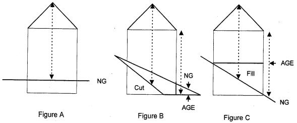
C. Roof Pitch and Massing.
1. Roof pitches shall not be less than four in 12.
2. Continuous walls of buildings in excess of 30 feet and fronting on a public street shall be broken with an offset of at least four feet for every 30 feet. Roof planes shall have corresponding offsets. See Figure D, below.
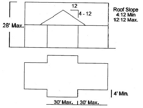
Figure D
D. Building Materials. Exterior wall surfaces shall be ship lap horizontal siding, shingles, vertical or horizontal tongue and groove siding, board and batten siding, or rough sawn textured panels with applied battens. However, other materials may be used for surface area which does not exceed 10 percent of the total wall surface area of the building, for decorative detail. (Ord. 25-2012 § 35; Ord. 46-2008 § 6(G))
Article VII. Country Corner Island Center Plan
18.30.450 Country Corner island center plan.
A. Amendments. All future amendments to this section of the San Juan County Code will follow the legislative procedures detailed in SJCC 18.90.020.
B. Applicability. This section applies to all land and land use activity and to all structures and facilities within Country Corner as shown on the official map.
C. Land Use Designation. The official map depicts one land use designation within the Country Corner island center: the Country Corner commercial designation (CCC). This designation exists:
1. To provide for a service/commercial center to the east of Eastsound which accommodates commercial services and construction-related activities along with office and retail uses that are necessary and important components of the local economy.
2. To allow for development that preserves the existing character, natural features and visual qualities by imposing specific development standards, including building height, setbacks and landscaped buffers between districts and open space.
3. To allow for a mixture of commercial uses and accessory residential units while protecting adjoining residential areas from incompatible commercial and industrial activities.
D. Relationship to Eastsound Subarea Plan. The area designated as Country Corner on the official map is part of the Eastsound Subarea. Issues not explicitly addressed in the Country Corner Plan are subject to Chapter 16.55 SJCC (Eastsound Subarea Plan).
E. Relationship to San Juan County Unified Development Code. Issues that are not explicitly addressed in either the Country Corner Plan or the Eastsound Subarea Plan are subject to the San Juan County Unified Development Code (UDC), SJCC Title 18. Following SJCC 18.10.050(G), however, where the regulations in the Country Corner Plan conflict with those of the Eastsound Subarea Plan or UDC, the Country Corner Plan regulations shall control. (Ord. 25-2012 § 36; Ord. 14-2010 § 6)
18.30.451 Allowed uses.
All development and uses within Country Corner shall conform to the table of permitted land uses in the following tables:
|
COMMERCIAL LAND USES |
CCC |
|
Animal Hospitals, Shelters and Veterinary Clinics |
C |
|
Automotive Service, Fuel and Repairs |
P |
|
Bed and Breakfast Inn (up to 5 units total) |
P/C |
|
Bed and Breakfast Residence |
N |
|
Camping Facilities |
N |
|
Day Care with 1 – 6 Children |
C |
|
Day Care with 7+ Children |
P/C |
|
Drinking Establishment |
C |
|
Eating Establishment |
C |
|
Equipment Rental Services |
P |
|
Hotel/Motel |
N |
|
Indoor Entertainment Facility |
P |
|
Landscaping, Nurseries and Retail Plant Sales |
P/C |
|
Nursing Homes |
N |
|
Personal Wireless Communication Facility |
C |
|
Personal and Professional Services |
Y |
|
Residential Care Facilities (up to 6 persons) |
N |
|
Residential Care Facilities (9 – 15 persons) |
N |
|
Camps, New |
N |
|
Resorts, New |
N |
|
Retail Sales and Services6 |
Y/C |
|
Vacation Rental of Residence or ADU |
N |
|
Mini-Storage, and Moving Storage Facilities |
C |
|
Laundromat |
C |
|
Car Wash |
N |
|
Unnamed Commercial Uses |
C |
|
INDUSTRIAL LAND USES |
CCC |
|
Bulk Fuel Storage Facility |
N |
|
Concrete and Concrete Batch Plants |
N |
|
Construction Yard and Related Businesses |
C |
|
Feedlots |
N |
|
Garbage and Solid Waste Transfer Stations |
N |
|
Heavy Industrial |
N |
|
Light Industrial |
N |
|
Light Manufacturing |
C |
|
Lumber Mills, Stationary |
N |
|
Outdoor Storage Yards |
N |
|
Recycling Center |
N |
|
Recycling Collection Point |
N |
|
Resource Processing Accessory to Extraction Operations |
N |
|
Mining and Mineral Extraction Activities |
N |
|
Reclamation of Mineral Extraction Sites |
N |
|
Wholesale Distribution Outlets |
N |
|
Wrecking and Salvage Yards |
N |
|
Storage and Treatment of Sewerage, Sludge, and Septage – Lagoon Systems |
N |
|
Unnamed Industrial Uses |
N |
|
INSTITUTIONAL LAND USES |
CCC |
|
College |
N |
|
Community Club or Community Organization Assembly Facility |
P/C |
|
Emergency Services |
P/C |
|
Government Offices |
N |
|
Institutional Camps |
N |
|
Library |
N |
|
Museum |
N |
|
Post Office |
N |
|
Religious Assembly Facility |
C |
|
School, Primary and Secondary |
N |
|
Technical School/Adult Education Facility |
N |
|
Unnamed Institutional Uses |
C |
|
RECREATIONAL LAND USES |
CCC |
|
Camping Facilities in Public Parks |
N |
|
Indoor Recreation Facilities |
P/C |
|
Outdoor Recreation Developments |
C |
|
Parks |
P |
|
Playing Fields |
C |
|
Recreational Vehicle Parks |
N |
|
Outdoor Shooting Ranges |
N |
|
Unnamed Recreational Uses |
C |
|
RESIDENTIAL LAND USES |
CCC |
|
Cottage Enterprise |
P/C |
|
Farm Labor Accommodations for Persons Employed in Agricultural Production on the Premises |
C |
|
Farm Stay |
N |
|
Home Occupation |
Y |
|
Mobile Home Parks |
N |
|
Multifamily Residential Units (3+ units) |
N |
|
Single-Family Residential (or apartment), Only as an Accessory to an Allowable Nonresidential Use |
Y |
|
Two-Family Residential (duplex) |
N |
|
Vacation Rental of Residential or Accessory Dwelling Unit |
N |
|
Unnamed Residential Uses |
C |
|
TRANSPORTATION LAND USES |
CCC |
|
Airfields |
N |
|
Airports |
N |
|
Airstrips |
N |
|
Hangars |
N |
|
Helipads |
N |
|
Helipads, Emergency Services |
N |
|
Parking Lots Commercial |
C |
|
Parking Structures |
C |
|
Streets, Public |
Y |
|
Streets, Private |
Y |
|
Trails and Paths, Public |
Y |
|
Unnamed Transportation Uses |
P/C |
|
UTILITIES LAND USES |
CCC |
|
Commercial Communication Facilities |
N |
|
Commercial Power Generation Facilities (except small single-family wind turbines) |
N |
|
Community Sewerage Treatment Facilities |
N |
|
Storage and Treatment of Sewerage, Sludge, and Septage – Systems Other Than Lagoons |
N |
|
Utility Distribution Lines |
Y |
|
Utility Facilities |
C |
|
Utility Substations |
N |
|
Utility Transmission Lines |
Y |
|
Community Water Systems |
P/C |
|
Water Treatment Facilities |
P/C |
|
Unnamed Utility Uses |
C |
|
AGRICULTURAL AND FORESTRY LAND USES |
CCC |
|
Agricultural and Aquacultural Processing, Retail, and Visitor-Serving Facilities for Products |
Y/C7 |
|
Agricultural Uses and Activities |
P/C |
|
Forest Practices, No Processing |
N |
|
Lumber Mills, Portable (existing) |
N |
|
Retail Sales of Agricultural Products |
Y8 |
|
Small-Scale Slaughterhouses |
N |
|
Unnamed Agricultural and Forestry Uses |
C |
Notes:
1. All land uses in all designations must meet the general regulations in SJCC 18.30.050 through 18.30.055 unless otherwise stated therein.
2. Overlay districts and subarea plans provide policies and regulations in addition to those of the underlying land use designations for certain land areas and for uses that warrant specific recognition and management. For any land use or development proposal located entirely or partly within an overlay district, or within the jurisdiction of a subarea plan, the applicable provisions of the overlay district or subarea plan as provided in Chapter 18.30 SJCC shall prevail over any conflicting provisions of this title.
3. Categories of uses:
Y = Yes. Uses allowed outright (i.e., without a project permit), subject to the applicable development standards (SJCC 18.30.452); if a building or other construction permit is required, this use is subject to administrative consistency review; see SJCC 18.80.070.
P = Provisional use subject to administrative consistency review for compliance with Chapter 18.60 SJCC development standards and Chapter 18.40 SJCC performance standards specific to the use; see SJCC 18.80.080.
P/C = Discretionary use: a discretionary use subject to administrative permit approval and consistency with Chapter 18.60 SJCC development standards. The administrator may require a conditional use permit based on project impacts (see SJCC 18.80.090 and Table 8.2).
C = Conditional use subject to public notice and permit hearing procedure; see SJCC 18.80.100.
N = Prohibited use.
4. The assignment of allowed and prohibited uses may not directly or indirectly preclude the siting of “essential public facilities.”
5. Forest practices (including timber harvesting), except for Class IV General (see SJCC 18.40.120 through 18.40.180), are regulated by the Washington Department of Natural Resources.
6. Retail operations with a footprint of 4,000 square feet or less are allowed outright (Y). Retail operations with a footprint larger than 4,000 square feet are required to obtain a conditional use permit (C).
7. Agricultural or aquacultural processing, retail, and visitor-serving facilities for products with a 4,000-square-foot footprint or less are allowed outright; facilities with a footprint that is larger than 4,000 square feet are required to obtain a conditional use permit.
8. Agricultural retail sales with a footprint of 4,000 square feet or less are allowed outright; facilities with a footprint that is larger than 4,000 square feet are required to obtain a conditional use permit.
(Ord. 2-2018 § 7; Ord. 25-2012 § 36; Ord. 14-2010 § 6. Formerly 18.30.450(F))
18.30.452 Development standards.
|
Development Standards |
|
|---|---|
|
Maximum Density |
One residential unit per half acre. Residential development permitted only as an accessory to an allowable commercial use.1 |
|
Minimum Lot Size |
1/2 acre |
|
Minimum Setback2,3,4,5 |
|
|
Front or Road6 (feet) |
35 ft. Crescent Beach Road/50 ft. Terrill Beach/Olga Road |
|
Rear and Side |
57/157 ft. |
|
Maximum Building Dimensions |
10,000 sq. ft. footprint |
|
Building Height8 |
309 ft. |
|
Lot Coverage10 |
40% |
|
Minimum open space11 |
30% |
|
Landscaping |
10 ft. buffer along public road frontage with Landscaping Screen C; 15 ft. buffer between commercial and residential districts with Landscaping Screen A. |
|
Parking |
Parking that requires cars to reverse into the County right-of-way will not be permitted under any condition. |
Notes:
1. The construction of residential units shall only occur simultaneously or after the development of the commercial use. In no case may the construction of new residential units be permitted prior to the allowable commercial use. All residential units must be located within the same structure/building as the commercial use.
2. Setbacks from roads shall be measured from the margin line of the road right-of-way. This measurement shall be to a line parallel to and measured perpendicularly from the appropriate line. Side and rear setbacks are measured from the edge of the property in the same manner as street setbacks.
3. Fences are exempt from setback requirements, except when they impair sight lines at intersections, as determined by the County engineer.
4. Setbacks do not apply to mail boxes, wells, pump houses, bus shelters, septic systems and drainfields, landscaping (including berms), utility apparatus such as poles, wires, pedestals, manholes, water pipes, water valves and vaults, and other items as approved by the director.
5. Road right-of-way setbacks may be waived, at the discretion of the County engineer, when the presence of shoreline setbacks, property lines, topography or other restrictions make it unreasonable to construct a structure without encroaching into the road right-of-way setback.
6. New development shall be required to maintain a 10-foot landscaped buffer along public street frontage. This landscaped strip will be created and maintained with a minimum of a “Screen C” in conformance with SJCC 18.60.160(E)(4).
7. New development will require a minimum five-foot setback on parcels beside other Country Corner commercial properties. Where parcels abut residential uses and zones there is a minimum 15-foot setback which must include “Screen A” landscaping in conformance with SJCC 18.60.160(D)(1).
8. Chimneys, smokestacks, fire or parapet walls, ADA-required elevator shafts, flagpoles, utility lines and poles, skylights, communication sending and receiving devices, HVAC and similar equipment, and spires associated with places of worship are exempt from height requirements.
9. A height bonus allowing a maximum height of 32 feet will be granted for those buildings with a minimum roof pitch of 6:12.
10. Lot coverage is the area of the lot covered by structures as determined by measurement of the physical footprint of the structures.
11. Open space (area not occupied by buildings, parking or driveways) shall be maintained in its natural condition or landscaped in conformance with SJCC 18.60.160.
(Ord. 25-2012 § 36; Ord. 14-2010 § 6. Formerly 18.30.450(G))
18.30.453 Building height measurement.
No structure shall exceed 30 feet above grade, measured as described in the illustration below. Structure height limit measurement methods are as follows:
A. Where the natural grade remains unchanged the structure height shall be measured by a plumb line from every point on the roof to the natural grade (NG). Natural grade shall mean the existing grade prior to any human modification. See Figure A, below.
B. Where the natural grade has been cut at any point around the structure footprint, the structure height shall be measured as by a plumb line from every point on the roof to the altered grade elevation (AGE). See Figure B, below.
C. Where fill material has been added to the natural grade, the structure height shall be measured as by a plumb line from every point on the roof to the natural grade, regardless of the height of fill. See Figure C, below.

(Ord. 25-2012 § 36; Ord. 14-2010 § 6. Formerly 18.30.450(H))
Article VIII. Eastsound Subarea Plan
18.30.460 Eastsound subarea land use regulations.
A. The following land use districts are based on existing land use patterns, natural features, and land capabilities, coordination with the Shoreline Master Program, and the needs and desires of the Orcas community as expressed in the goals and policies of the subarea plan. The districts are:
1. Village commercial‡ (minimum four – maximum 40 units/acre);
2. Village residential/institutional‡ (minimum four – maximum 12 units/acre);
3. Service and light industrial‡;
4. Eastsound residential‡:
One unit/acre P*;
Two units/acre;
Two units/acre P*;
Four units/acre P*;
Minimum four – maximum 12 units/acre;
5. Service park;
6. Marina (maximum six – eight units/acre);
7. Eastsound airport‡;
8. Country corner commercial;
9. Eastsound rural residential‡:
One unit/five acres;
One unit/two acres;
10. Eastsound rural (maximum one unit/five acres);
11. Natural; and
12. Conservancy overlay.
Some areas within land use districts marked by an “‡” are also subject to the airport overlay requirements in SJCC 18.40.031 and 18.40.032.
Residential density designations with a “P*” indicate those locations where site planning is required under SJCC 18.60.240. This planning is necessary to ensure that development at less than four units per acre density will not preclude possible future development at urban-level densities (four units per acre or higher). New residential development in such areas is subject to approval by the director for this purpose.
Retail sales, laundries and laundromats, equipment rentals, restaurants, and post offices are prohibited in the portion of the village commercial district described as follows: between High School and Rose Streets and east of Pine Street and all areas east of Madrona Street.
Uses that are prohibited in the land use table may be allowed as a cottage industry or home occupation; provided, that the use meets the requirements set forth in SJCC 18.40.190 and SJCC 18.60.180. “Cottage enterprise” and “home occupation” describe the intensity of a use instead of a specific type of use.
The following tables which show allowed and prohibited uses are followed by the development standards and specific development conditions that apply to each land use district. (Ord. 11-2020 § 4; Ord. 21-2015 § 2)
18.30.461 Allowed commercial uses by Eastsound land use district.
|
Commercial Uses by Eastsound Land Use District1 |
Village Commercial‡ (min. 4 – max. 40 units/acre) |
Village Residential/ Institutional‡ (min. 4 – max. 12 units/acre) |
Service and Light Industrial‡ |
Eastsound Residential‡ 1 unit/acre P* 2 unit/acre 2 unit/acre P* 4 unit/acre P* (min. 4 – max. 12 units/acre) |
Service Park |
Marina‡ (max. 6 – 8 units/acre) |
Eastsound Airport‡ |
Country Corner Commercial |
Eastsound Rural Residential 1 unit/5 acres, 1 unit/2 acres |
Eastsound Rural (max. 1 unit/5 acres) |
Eastsound Natural |
|---|---|---|---|---|---|---|---|---|---|---|---|
|
Veterinarian Office Small animals only |
YES |
YES |
YES |
NO |
YES |
NO |
NO |
CUP |
NO |
NO |
NO |
|
Animal Shelters/Hospitals and Kennels |
NO |
NO |
YES (must be enclosed or screened) |
NO |
YES |
NO |
NO |
CUP |
NO |
NO |
NO |
|
Automotive Fuel, Service and Repair Stations |
NO |
NO |
YES |
NO |
YES |
NO |
YES (airplane service and repair) |
PROV |
NO |
NO |
NO |
|
Bed and Breakfast Inn (2 – 5 Rooms) |
YES |
PROV |
NO |
PROV |
NO |
CUP |
NO |
P/C |
PROV |
PROV |
NO |
|
Bed and Breakfast Residence (1 – 2 Rooms) |
YES |
PROV |
NO |
YES |
YES |
YES |
NO |
NO |
YES |
PROV |
NO |
|
Day Care with 1 – 6 Children |
YES |
YES |
NO |
YES |
YES |
CUP |
NO |
CUP |
YES |
YES |
NO |
|
Day Care with 7+ Children |
YES |
YES |
NO |
YES |
YES |
CUP |
NO |
P/C |
YES |
CUP |
NO |
|
Drinking Establishment |
YES |
NO |
NO |
NO |
NO |
YES |
NO |
CUP |
NO |
NO |
NO |
|
Eating Establishment |
YES2 |
NO |
NO |
NO |
NO |
YES |
YES |
CUP |
NO |
NO |
NO |
|
Hotel/Motel |
YES |
NO |
NO |
NO |
YES (5 rooms max.) |
YES |
NO |
NO |
NO |
NO |
NO |
|
Indoor Entertainment Facility inc. Theater |
YES |
YES |
NO |
NO |
NO |
YES |
CUP |
PROV |
NO |
NO |
NO |
|
Food Vending Trailer |
YES |
NO |
NO |
NO |
NO |
YES |
YES |
YES |
NO |
NO |
NO |
|
Kiosk |
YES |
NO |
NO |
NO |
NO |
YES |
YES |
NO |
NO |
NO |
NO |
|
Nursing Homes |
YES |
YES |
NO |
CUP |
NO |
YES |
NO |
NO |
CUP |
NO |
NO |
|
Personal and Professional Services |
YES |
YES |
YES |
NO |
YES |
YES |
YES |
YES |
NO |
NO |
NO |
|
Personal Wireless Communications Service Facilities at Potentially Suitable Locations |
YES |
YES |
YES |
NO |
YES |
YES |
YES |
CUP |
NO |
YES |
NO |
|
Residential Care Facilities with up to 8 Persons |
YES |
YES |
NO |
YES |
NO |
YES |
NO |
NO |
YES |
CUP |
NO |
|
Residential Care Facilities with 9 – 15 Persons |
YES |
YES |
NO |
YES |
NO |
YES |
NO |
NO |
YES |
CUP |
NO |
|
Resorts and Camps, New |
NO |
CUP |
NO |
NO |
NO |
YES |
NO |
NO |
NO |
NO |
NO |
|
Equipment Rental Services |
YES2 |
NO |
YES |
NO |
YES |
YES |
YES |
PROV |
NO |
NO |
NO |
|
Construction Related Businesses – No Outdoor Storage Unless Screened |
YES |
NO |
YES |
NO |
YES |
YES |
YES |
YES |
NO |
NO |
NO |
|
Retail Sales and Services |
YES2 |
NO |
YES (only if related to other allowed uses or business requiring substantial storage or products manufactured in same facility) |
NO |
YES (only if related to other allowed uses or business requiring substantial storage or products manufactured in same facility) |
PROV |
YES (planes and related products only) |
YES/CUP |
NO |
NO |
NO |
|
Artisan Activities |
YES |
NO |
CUP |
NO |
CUP |
NO |
NO |
NO |
NO |
NO |
NO |
|
Marina and Related Retail, Repair and Rentals |
YES |
NO |
YES |
NO |
YES |
YES |
NO |
NO |
NO |
NO |
NO |
|
Laundry/ Laundromat |
YES2 |
NO |
YES |
NO |
NO |
YES |
YES |
CUP |
NO |
NO |
NO |
|
Warehouse, Mini-storage, and Moving Storage Facilities |
NO |
NO |
YES |
NO |
YES |
NO |
YES |
CUP |
NO |
NO |
NO |
|
Landscaping, Lawn and Garden Centers, Nurseries and Retail Plant Sales |
YES |
NO |
YES |
NO |
YES |
NO |
NO |
P/C |
NO |
NO |
NO |
|
Car Wash |
NO |
NO |
YES |
NO |
YES |
YES |
CUP |
NO |
NO |
NO |
NO |
|
Unnamed Commercial Uses |
CUP |
CUP |
CUP |
CUP |
CUP |
CUP |
CUP |
CUP |
CUP |
CUP |
CUP |
1Uses that are prohibited in the land use table may be allowed as a cottage industry or home occupation; provided, that the use meets the requirements set forth in SJCC 18.40.190 and 18.60.180. “Cottage enterprise” and “home occupation” describe the intensity of a use instead of a specific type of use.
2This use prohibited within that portion of the village commercial district described as follows: between High School and Rose Streets and east of Pine Street, and all areas east of Madrona Street.
(Ord. 11-2020 § 4; Ord. 21-2015 § 2)
18.30.462 Allowed industrial uses by Eastsound land use district.
|
Industrial Uses by Eastsound Land Use District1 |
Village Commercial‡ (min. 4 – max. 40 units/acre) |
Village Residential/ Institutional‡ (min. 4 – max. 12 units/acre) |
Service and Light Industrial‡ |
Eastsound Residential‡ 1 unit/acre P* 2 unit/acre 2 unit/acre P* 4 unit/acre P* (min. 4 – max. 12 units/acre) |
Service Park |
Marina‡ (max. 6 – 8 units/acre) |
Eastsound Airport‡ |
Country Corner Commercial |
Eastsound Rural Residential 1 unit/5 acres, 1 unit/2 acres |
Eastsound Rural (max. 1 unit/5 acres) |
Eastsound Natural |
|---|---|---|---|---|---|---|---|---|---|---|---|
|
Bulk Fuel Storage Facilities |
NO |
NO |
CUP |
NO |
CUP |
CUP |
CUP |
NO |
NO |
NO |
NO |
|
Concrete and Concrete Batch Plants |
NO |
NO |
NO |
NO |
NO |
NO |
NO |
NO |
NO |
NO |
NO |
|
Construction Yards |
NO |
NO |
YES |
NO |
YES |
NO |
YES |
CUP |
NO |
NO |
NO |
|
Feedlots |
NO |
NO |
NO |
NO |
NO |
NO |
NO |
NO |
NO |
NO |
NO |
|
Garbage and Solid Waste Transfer Stations |
NO |
NO |
CUP |
NO |
NO |
NO |
NO |
NO |
NO |
NO |
NO |
|
Heavy Equipment Rental Services |
NO |
NO |
YES |
NO |
YES |
NO (yes as accessory to marina) |
NO |
NO |
NO |
NO |
NO |
|
Heavy Industrial |
NO |
NO |
NO |
NO |
NO |
NO |
NO |
NO |
NO |
NO |
NO |
|
Light Manufacturing |
NO |
NO |
YES (enclosed by building – outside storage to be screened) |
NO |
YES (enclosed by building – outside storage to be screened) |
NO |
YES |
CUP |
NO |
NO |
NO |
|
Lumber Mills, Stationary |
NO |
NO |
CUP |
NO |
CUP |
NO |
NO |
NO |
NO |
NO |
NO |
|
Marijuana Production and Processing, Tiers 1 and 22 |
CUP |
NO |
CUP |
NO |
CUP |
NO |
NO |
CUP |
NO |
NO |
NO |
|
Marijuana Production and Processing, Tier 3 |
NO |
NO |
NO |
NO |
NO |
NO |
NO |
NO |
NO |
NO |
NO |
|
Outdoor Storage Yards |
NO |
NO |
YES |
NO |
YES |
YES |
YES |
NO |
NO |
NO |
NO |
|
Recycling Center |
NO |
NO |
YES |
NO |
CUP |
CUP |
NO |
NO |
NO |
NO |
NO |
|
Recycling Collection Point |
NO |
YES |
YES |
NO |
YES |
YES |
NO |
YES |
NO |
NO |
NO |
|
Resource Processing Accessory to Extraction Operations |
NO |
NO |
NO |
NO |
NO |
NO |
NO |
NO |
NO |
NO |
NO |
|
Mining and Mineral Extraction Activities |
NO |
NO |
NO |
NO |
NO |
NO |
NO |
NO |
NO |
NO |
NO |
|
Reclamation of Mineral Extraction Sites |
NO |
NO |
NO |
NO |
NO |
NO |
NO |
NO |
NO |
NO |
NO |
|
Wholesale Distribution Outlet |
NO |
NO |
YES |
NO |
YES |
NO |
YES |
NO |
NO |
NO |
NO |
|
Wrecking and Salvage Yards |
NO |
NO |
CUP |
NO |
NO |
NO |
NO |
NO |
NO |
NO |
NO |
|
Storage and Treatment of Sewerage, Sludge and Septage – Lagoon Systems |
NO |
NO |
YES |
NO |
NO |
NO |
NO |
NO |
NO |
NO |
NO |
|
Unnamed Industrial Uses |
NO |
NO |
CUP |
NO |
NO |
NO |
CUP |
NO |
NO |
NO |
NO |
1Uses that are prohibited in the land use table may be allowed as a cottage industry or home occupation; provided, that the use meets the requirements set forth in SJCC 18.40.190 and 18.60.180. “Cottage enterprise” and “home occupation” describe the intensity of a use instead of a specific type of use.
2 In the Eastsound urban growth area and subarea, marijuana production is allowed in fully enclosed and secure structures such as stick-built buildings or opaque greenhouses with rigid walls, a roof and doors. The maximum amount of space for marijuana production cannot exceed the amount licensed by the State Liquor and Cannabis Control Board.
Applicants must designate the proposed production tier and amount of square footage of plant canopy on land use and building permit application plans. The marijuana production tiers and canopy limits are:
(a) Tier 1: Less than 2,000 square feet;
(b) Tier 2: Two thousand square feet up to 10,000 square feet; and
(c) Tier 3: Ten thousand square feet up to 30,000 square feet.
(Ord. 11-2020 § 4; Ord. 21-2015 § 2)
18.30.463 Allowed institutional uses by Eastsound land use district.
|
Institutional Uses by Eastsound Land Use District1 |
Village Commercial‡ (min. 4 – max. 40 units/acre) |
Village Residential/ Institutional‡ (min. 4 – max. 12 units/acre) |
Service and Light Industrial‡ |
Eastsound Residential‡ 1 unit/acre P* 2 unit/acre 2 unit/acre P* 4 unit/acre P* (min. 4 – max. 12 units/acre) |
Service Park |
Marina‡ (max. 6 – 8 units/acre) |
Eastsound Airport‡ |
Country Corner Commercial |
Eastsound Rural Residential 1 unit/5 acres, 1 unit/2 acres |
Eastsound Rural (max. 1 unit/5 acres) |
Eastsound Natural |
|---|---|---|---|---|---|---|---|---|---|---|---|
|
College or Technical School/Adult Education Facility |
YES |
YES |
YES |
NO |
YES |
YES |
YES |
NO |
NO |
NO |
NO |
|
Community Club or Community Organization Assembly Facility |
YES |
YES |
NO |
YES |
NO |
CUP |
NO (YES if related to aviation) |
YES |
YES |
NO |
NO |
|
Cultural Facility |
YES |
YES |
NO |
NO |
NO |
NO (YES if nautical) |
NO (YES if related to aviation) |
NO |
NO |
NO |
YES |
|
Emergency Services |
YES |
YES |
YES |
YES |
YES |
YES |
YES |
P/C |
YES |
YES |
NO |
|
Government Offices |
YES |
YES |
YES |
NO |
YES |
YES |
YES |
NO |
NO |
NO |
NO |
|
Institutional Camps |
NO |
NO |
NO |
NO |
NO |
NO |
NO |
NO |
NO |
NO |
NO |
|
Library |
YES |
NO |
NO |
NO |
NO |
NO |
NO |
NO |
NO |
NO |
NO |
|
Museum |
YES |
NO |
NO |
NO |
NO |
YES |
YES |
NO |
NO |
NO |
NO (YES if directly related to site) |
|
Post Office |
YES2 |
NO |
NO |
NO |
NO |
NO |
NO |
NO |
NO |
NO |
NO |
|
Religious Assembly Facility |
YES |
YES |
NO |
NO |
NO |
NO |
NO |
NO |
NO |
NO |
NO |
|
School, Primary and Secondary |
YES |
YES |
NO |
NO |
NO |
NO |
NO |
NO |
NO |
NO |
NO |
|
Unnamed Institutional Uses |
CUP |
CUP |
NO |
NO |
CUP |
CUP |
CUP |
NO |
NO |
NO |
NO |
1Uses that are prohibited in the land use table may be allowed as a cottage industry or home occupation; provided, that the use meets the requirements set forth in SJCC 18.40.190 and 18.60.180. “Cottage enterprise” and “home occupation” describe the intensity of a use instead of a specific type of use.
2This use prohibited within that portion of the village commercial district described as follows: between High School and Rose Streets and east of Pine Street, and all areas east of Madrona Street.
(Ord. 11-2020 § 4; Ord. 21-2015 § 2)
18.30.464 Allowed recreational uses by Eastsound land use district.
|
Recreational Uses by Eastsound Land Use District1 |
Village Commercial‡ (min. 4 – max. 40 units/acre) |
Village Residential/ Institutional‡ (min. 4 – max. 12 units/acre) |
Service and Light Industrial‡ |
Eastsound Residential‡ 1 unit/acre P* 2 unit/acre 2 unit/acre P* 4 unit/acre P* (min. 4 – max. 12 units/acre) |
Service Park |
Marina‡ (max. 6 – 8 units/acre) |
Eastsound Airport‡ |
Country Corner Commercial |
Eastsound Rural Residential 1 unit/5 acres, 1 unit/2 acres |
Eastsound Rural (max. 1 unit/5 acres) |
Eastsound Natural |
|---|---|---|---|---|---|---|---|---|---|---|---|
|
Camping Facilities in Public Parks |
NO |
NO |
NA |
NO |
NA |
NO |
NA |
NO |
NO |
NO |
NO |
|
Indoor Recreation Facilities |
YES |
YES |
YES |
NO |
YES |
YES |
NO |
CUP |
NO |
NO |
NO |
|
Outdoor Recreation Developments |
YES |
CUP |
NO |
NO |
YES |
YES |
YES |
CUP |
NO |
YES |
YES |
|
Parks |
YES |
YES |
YES |
PROV |
NO |
YES |
NO |
PROV |
PROV |
YES |
YES (no camping or playing fields) |
|
Playing Fields |
YES |
YES |
YES |
PROV |
NO |
YES |
NO |
CUP |
PROV |
YES |
NO |
|
Recreational Vehicle Parks |
NO |
NO |
CUP |
NO |
NO |
NO |
NO |
NO |
NO |
NO |
NO |
|
Outdoor Shooting Ranges |
NO |
NO |
CUP |
NO |
NO |
NO |
NO |
NO |
NO |
NO |
NO |
|
Unnamed Recreational Uses |
CUP |
CUP |
CUP |
CUP |
CUP |
CUP |
CUP |
CUP |
CUP |
CUP |
CUP |
1Uses that are prohibited in the land use table may be allowed as a cottage industry or home occupation; provided, that the use meets the requirements set forth in SJCC 18.40.190 and 18.60.180. “Cottage enterprise” and “home occupation” describe the intensity of a use instead of a specific type of use.
(Ord. 11-2020 § 4; Ord. 21-2015 § 2)
18.30.465 Allowed residential uses by Eastsound land use district.
|
Residential Uses by Eastsound Land Use District1 |
Village Commercial‡ (min. 4 – max. 40 units/acre) |
Village Residential/ Institutional‡ (min. 4 – max. 12 units/acre) |
Service and Light Industrial‡ |
Eastsound Residential‡ 1 unit/acre P* 2 unit/acre 2 unit/acre P* 4 unit/acre P* (min. 4 – max. 12 units/acre) |
Service Park |
Marina‡ (max. 6 – 8 units/acre) |
Eastsound Airport‡ |
Country Corner Commercial |
Eastsound Rural Residential 1 unit/5 acres, 1 unit/2 acres |
Eastsound Rural (max. 1 unit/5 acres) |
Eastsound Natural |
|---|---|---|---|---|---|---|---|---|---|---|---|
|
Cottage Enterprise |
YES |
PROV |
NO |
YES |
YES |
YES |
NO |
P/C |
YES |
YES |
NO |
|
Farm Labor Accommodations for Persons Employed in Agricultural Production on the Premises |
NO |
YES |
NO |
YES |
NO |
NO |
NO |
CUP |
YES |
YES |
NO |
|
Farm Stay |
NO |
YES |
NO |
YES |
NO |
NO |
NO |
NO |
YES |
CUP |
NO |
|
Home Occupation |
YES |
YES |
YES |
YES |
YES |
YES |
NO |
YES |
YES |
YES |
NO |
|
Mobile Home Parks |
NO |
CUP |
NO |
CUP |
NO |
NO |
NO |
NO |
CUP |
CUP |
NO |
|
Multifamily Residential Units (3+ Units) |
YES |
YES |
NO |
YES |
NO |
YES |
NO |
NO |
YES |
CUP |
NO |
|
Single-Family Residential Unit |
YES |
YES |
NO |
YES |
NO |
YES |
NO |
YES |
YES |
YES |
NO |
|
Accessory Dwelling Unit (1 Unit per Lot; Accessory to an Allowable Use) |
YES |
YES |
YES (only 1 per lot and only within the commercial structure) |
YES |
YES |
YES |
NO |
YES |
YES |
YES |
NO |
|
Two-Family Residential (Duplex) |
YES |
YES |
NO |
YES |
NO |
YES |
NO |
NO |
YES |
NO |
NO |
|
Group Housing |
YES |
YES |
NO |
CUP |
NO |
NO |
NO |
NO |
CUP |
CUP |
NO |
|
Vacation Rental of Residence or Accessory Dwelling Unit |
YES |
PROV |
NO |
PROV |
NO |
PROV |
NO |
NO |
PROV |
PROV |
NO |
|
Rural Residential Cluster Development |
NO |
NO |
NO |
NO |
NO |
NO |
NO |
NO |
YES in Eastsound rural residential 1 unit per 5 acres. No in ERR 1 unit per 2 acres |
YES |
NO |
|
Unnamed Residential Uses |
CUP |
CUP |
CUP |
CUP |
CUP |
CUP |
NO |
CUP |
CUP |
CUP |
CUP |
1Uses that are prohibited in the land use table may be allowed as a cottage industry or home occupation; provided, that the use meets the requirements set forth in SJCC 18.40.190 and 18.60.180. “Cottage enterprise” and “home occupation” describe the intensity of a use instead of a specific type of use.
(Ord. 11-2020 § 4; Ord. 21-2015 § 2)
18.30.466 Allowed transportation uses by Eastsound land use district.
|
Transportation Uses by Eastsound Land Use District1 |
Village Commercial‡ (min. 4 – max. 40 units/acre) |
Village Residential/ Institutional‡ (min. 4 – max. 12 units/acre) |
Service and Light Industrial‡ |
Eastsound Residential‡ 1 unit/acre P* 2 unit/acre 2 unit/acre P* 4 unit/acre P* (min. 4 – max. 12 units/acre) |
Service Park |
Marina‡ (max. 6 – 8 units/acre) |
Eastsound Airport‡ |
Country Corner Commercial |
Eastsound Rural Residential 1 unit/5 acres, 1 unit/2 acres |
Eastsound Rural (max. 1 unit/5 acres) |
Eastsound Natural |
|---|---|---|---|---|---|---|---|---|---|---|---|
|
Airfields |
NO |
NO |
NO |
NO |
NO |
NO |
YES |
NO |
NO |
NO |
NO |
|
Airports |
NO |
NO |
NO |
NO |
NO |
NO |
YES |
NO |
NO |
NO |
NO |
|
Airport Related Uses |
NO |
NO |
YES |
NO |
NO |
YES (except sales and repair of planes) |
YES (including parking and tie down areas) |
NO |
NO |
NO |
NO |
|
Airstrips |
NO |
NO |
NO |
NO |
NO |
N/A |
YES |
NO |
NO |
NO |
NO |
|
Hangars |
NO |
NO |
YES |
NO (YES on property adjacent to existing runway and/or have deeded access) |
NO |
NO (YES on property adjacent to existing runway and/or have deeded access) |
YES |
NO |
NO |
NO |
NO |
|
Helipads |
NO |
NO |
CUP |
NO |
NO |
NO |
YES |
NO |
NO |
NO |
NO |
|
Helipads, Emergency Services |
NO |
NO |
YES |
NO |
YES |
YES |
YES |
NO |
NO |
NO |
NO |
|
Ferry Terminal |
CUP |
NO |
CUP |
NO |
NO |
YES |
YES |
N/A |
NO |
NO |
NO |
|
Parking Off-Site |
YES |
YES |
YES |
NO |
YES |
YES |
YES |
N/A |
NO |
NO |
NO |
|
Parking On-Site |
YES |
YES |
YES |
YES |
YES |
YES |
YES |
NO |
YES |
YES |
NO |
|
Parking Lots, Commercial |
YES |
CUP |
YES |
NO |
YES |
YES |
YES |
CUP |
NO |
NO |
NO |
|
Parking Structures |
CUP |
NO |
YES |
NO |
YES |
CUP |
CUP |
CUP |
NO |
NO |
NO |
|
Streets, Public and Private |
YES |
YES |
YES |
YES |
YES |
YES |
YES |
YES |
YES |
YES |
YES |
|
Trails and Paths, Public |
YES |
YES |
YES |
YES |
YES |
YES |
YES |
YES |
YES |
YES |
YES |
|
Unnamed Transportation Uses |
CUP |
CUP |
CUP |
CUP |
CUP |
CUP |
YES |
CUP |
CUP |
CUP |
CUP |
1Uses that are prohibited in the land use table may be allowed as a cottage industry or home occupation; provided, that the use meets the requirements set forth in SJCC 18.40.190 and 18.60.180. “Cottage enterprise” and “home occupation” describe the intensity of a use instead of a specific type of use.
(Ord. 11-2020 § 4; Ord. 21-2015 § 2)
18.30.467 Allowed utilities uses by Eastsound land use district.
|
Utilities Uses by Eastsound Land Use District1 |
Village Commercial‡ (min. 4 – max. 40 units/acre) |
Village Residential/ Institutional‡ (min. 4 – max. 12 units/acre) |
Service and Light Industrial‡ |
Eastsound Residential‡ 1 unit/acre P* 2 unit/acre 2 unit/acre P* 4 unit/acre P* (min. 4 – max. 12 units/acre) |
Service Park |
Marina‡ (max. 6 – 8 units/acre) |
Eastsound Airport‡ |
Country Corner Commercial |
Eastsound Rural Residential 1 unit/5 acres, 1 unit/2 acres |
Eastsound Rural (max. 1 unit/5 acres) |
Eastsound Natural |
|---|---|---|---|---|---|---|---|---|---|---|---|
|
Commercial Communication Facilities |
CUP |
NO |
YES |
NO |
NO |
NO |
YES |
NO |
NO |
NO |
NO |
|
Commercial Power-Generation Facilities |
NO |
NO |
NO |
NO |
YES |
NO |
YES |
NO |
NO |
NO |
NO |
|
Solar Panels |
YES |
YES |
YES |
YES |
YES |
YES |
YES |
YES |
YES |
YES |
NO |
|
Community Sewerage Treatment Facilities |
NO |
NO |
YES |
YES |
NO |
NO |
YES |
NO |
NO |
NO |
NO |
|
Storage and Treatment of Sewerage, Sludge and Septage – Systems Other Than Lagoons |
NO |
NO |
YES |
YES |
NO |
NO |
YES |
NO |
YES |
NO |
NO |
|
Utility Distribution Lines Water, Stormwater, Power, Cable TV, Data Transmission, Personal Wireless Facilities, Telephone, and Sewer |
YES |
YES |
YES |
YES |
YES |
YES |
YES |
YES |
YES (NO sewer) |
YES (NO sewer) |
YES |
|
Utility Facilities Including Storage, Maintenance, Service, Operations and Other Support Offices |
CUP |
YES |
YES |
NO offices YES storage and utility support buildings |
YES |
YES |
YES |
CUP |
NO offices YES storage and utility support buildings |
YES = up to 400 square feet (NO office or storage buildings) |
YES (NO office or storage buildings) |
|
Utility Substations |
NO |
NO |
YES |
YES |
YES |
YES |
YES |
NO |
YES |
YES |
NO |
|
Water Storage Tanks, Community |
YES |
YES |
YES |
YES |
YES |
YES |
YES |
P/C |
YES |
YES |
NO |
|
Water Treatment Facilities |
NO |
YES |
YES |
YES |
YES |
YES |
YES |
P/C |
YES |
YES |
NO |
|
Unnamed Utility Uses |
CUP |
CUP |
CUP |
CUP |
CUP |
CUP |
CUP |
CUP |
CUP |
CUP |
CUP |
1Uses that are prohibited in the land use table may be allowed as a cottage industry or home occupation; provided, that the use meets the requirements set forth in SJCC 18.40.190 and 18.60.180. “Cottage enterprise” and “home occupation” describe the intensity of a use instead of a specific type of use.
(Ord. 11-2020 § 4; Ord. 21-2015 § 2)
18.30.468 Allowed agricultural uses by Eastsound land use district.
|
Agricultural and Forestry Uses by Eastsound Land Use District1 |
Village Commercial‡ (min. 4 – max. 40 units/acre) |
Village Residential/ Institutional‡ (min. 4 – max. 12 units/acre) |
Service and Light Industrial‡ |
Eastsound Residential‡ 1 unit/acre P* 2 unit/acre 2 unit/acre P* 4 unit/acre P* (min. 4 – max. 12 units/acre) |
Service Park |
Marina‡ (max. 6 – 8 units/acre) |
Eastsound Airport‡ |
Country Corner Commercial |
Eastsound Rural Residential 1 unit/5 acres, 1 unit/2 acres |
Eastsound Rural (max. 1 unit/5 acres) |
Eastsound Natural |
|---|---|---|---|---|---|---|---|---|---|---|---|
|
Agricultural Processing, Retail, and Visitor-Serving Facilities for Products |
YES |
YES |
YES |
CUP |
YES |
YES |
NO |
YES/CUP |
CUP |
YES |
NO |
|
Agricultural Uses and Activities |
YES |
YES |
NO |
YES |
YES |
YES |
NO |
P/C |
YES |
YES |
NO |
|
Forest Practices, No Processing |
NO |
NO |
NO |
NO |
NO |
NO |
NO |
NO |
NO |
YES |
NO |
|
Lumber Mills, Portable |
NO |
NO |
YES |
NO |
CUP |
NO |
NO |
NO |
NO |
YES |
NO |
|
Nurseries |
YES |
CUP |
YES |
NO |
YES |
NO |
YES |
NO |
NO |
YES |
NO |
|
Agricultural Sales |
YES |
YES |
YES |
YES |
YES |
NO |
YES |
YES |
YES |
YES |
NO |
|
Small-Scale Slaughterhouses |
NO |
NO |
CUP |
NO |
NO |
NO |
NO |
NO |
NO |
NO |
NO |
|
Unnamed Agricultural and Forestry Uses |
CUP |
CUP |
CUP |
CUP |
CUP |
CUP |
CUP |
CUP |
CUP |
CUP |
CUP |
1Uses that are prohibited in the land use table may be allowed as a cottage industry or home occupation; provided, that the use meets the requirements set forth in SJCC 18.40.190 and 18.60.180. “Cottage enterprise” and “home occupation” describe the intensity of a use instead of a specific type of use.
(Ord. 11-2020 § 4; Ord. 21-2015 § 2)
18.30.470 Eastsound village commercial district.
|
Development Standards |
Dimensions/Placement |
Permits, Conditions and Limits |
|---|---|---|
|
Residential Density |
Minimum 4 units per acre. Maximum 40 units per acre. |
|
|
Minimum Lot Size |
N/A |
|
|
Building Height |
Maximum 35 feet. |
See SJCC 18.30.600 for the method of measuring height. (Excluding church spires if the area at the base is not larger than 5 percent of building floor area.) |
|
Building Front Setback |
30 feet to the centerline of public right-of-way. |
Building setbacks from shorelines on lots not included in the Eastsound waterfront access plan are subject to policies and regulations in Chapter 18.50 SJCC and Section B.3 of the Comprehensive Plan, the Shoreline Master Program. |
|
Side and Rear Setback |
Side and rear yards – 5 feet from the property line. |
Architectural appendages (i.e., roof overhangs, chimneys, bay windows, and decks not over 30 inches above grade) may extend 2 feet into required setback. |
|
Eastsound Waterfront Access Plan Setbacks |
Building setbacks for existing, expanded, new, or replacement structures on properties in the Eastsound waterfront access plan are set forth therein. Building envelopes and setbacks are shown on Figure 130-6 of the Eastsound Subarea Plan. Land use and shoreline permits for the urban shoreline designation may also be subject to easements and agreement with San Juan County. |
|
|
Utilities |
Underground. |
Except when enhancing, repairing, replacing or relocating existing facilities. |
|
Outdoor Storage |
Storage area must be screened from view from public roads and shoreline. |
Screening must be no less than 5 feet high consisting of fencing, vegetation or other materials. |
|
Open Space (area not occupied by buildings, parking and driveways) |
10 percent of the lot shall be open space exclusive of any street front pedestrian easement. |
Maintained in natural condition or landscaped. Applications to specify open space and identify landscape features. Open space is required for all new and expanded developments and shall be visible from public street. |
|
Lot Coverage |
Buildings larger than 5,000 square feet in net use building area shall not exceed 65 percent of the lot. |
Lot coverage is the area covered by buildings, parking and driveways and does not apply to single-family residential development in village commercial. |
|
Landscaping |
Screening shall be required between residential and nonresidential developments. Parking areas shall be landscaped in accordance with standards in SJCC 18.30.630 and other landscaping required in this section shall comply with standards in SJCC 18.30.670(D). |
|
|
Personal Wireless Service Facilities (PWSF) |
PWSFs are subject to the provisions of SJCC 18.40.590, 18.40.600, and 18.40.610. |
|
|
Additional Conditions Applicable to all Eastsound Village Commercial Lots |
||
|
Artisan activities shall meet the following requirements: A. Have goods and services for sale to the general public; B. Outdoor storage areas exceeding 500 square feet shall not be visible from adjacent properties or rights-of-way; C. Employs or contracts no more than 6 persons on site; D. Manufacturing activities shall be enclosed; and E. No use shall be made of equipment or material which produces unreasonable vibration, noise, dust, smoke, odor, or electrical interference to the detriment of adjoining property. F. The owner(s) of an artisan activity shall certify compliance with performance standards in subsections (A) through (E) of this section, at the time the business commences, every 5 years, and at the time of sale of the property. Written certification shall be submitted to the department in a format approved by the director. |
||
|
Adult family homes and in-home day care facilities which exceed standards for the uses set out in SJCC 18.60.180 are allowed only as provided above and as a conditional use permit. |
||
|
“Cottage enterprise” and “home occupation” describe the intensity of a use instead of a specific type of use. Uses that are prohibited in the land use table may be allowed as a cottage industry or home occupation; provided, that the use meets the requirements set forth in SJCC 18.40.190 and 18.60.180. |
||
|
Additional required parking spaces, driveways and paths are considered and permitted as part of any change of use application. |
||
|
Classroom uses for primary and secondary education are allowed outright if parking is provided in conformance with requirements in SJCC 18.30.630. |
||
|
All buildings except single-family homes must meet the design standards in SJCC 18.30.670(B). |
||
|
Limited areas of land use districts marked with an “‡” are subject to the airport overlay provisions in SJCC 18.40.031 through 18.40.032. |
||
(Ord. 21-2015 § 3)
18.30.480 Tax parcels regulated by Eastsound waterfront access plan.
|
Tax Parcel Number |
Front Setbacks (Main St.) |
Rear Setbacks (East Sound Shoreline) |
Left Setbacks (East) |
Right Setbacks (West) |
|---|---|---|---|---|
|
271442007 271442008 271441012 |
38 feet or existing footprint for Emmanuel Church.
10 feet or existing footprint for Benson Hall. |
The lesser of 15 feet from the top-of-bank (measured from the +8 feet OHWM) or the existing footprint. |
5 feet or existing footprint, subject to the presence of an existing structure (currently occupied by San Juan Insurance Center). Upon removal of this structure, this setback shall become effective and not blocked in the future by new or expanded construction. |
10 feet |
|
271451010 |
5 feet. |
5 feet from the top-of-bank (measured from the seaward face of the existing riprap bulkhead) for structures. Decks may project to the landward edge of the riprap line. |
5 feet. |
5 feet. |
|
271451012 271451022 |
5 feet or existing footprint. |
5 feet from the OHWM for structures. Decks may project to any bulkhead line. |
5 feet. |
5 feet. |
|
271451013 |
16 feet or existing footprint. |
The lesser of 15 feet from the top-of-bank (measured from the +8 feet OHWM) or the existing footprint for buildings and decks, as shown on Figure 130-6 of the Eastsound Subarea Plan. |
5 feet. |
5 feet. |
|
271460050 |
29 feet or existing footprint except canopy over gas pumps. |
The lesser of 15 feet from the top-of-bank (measured from the +8 feet OHWM) or the existing footprint. |
5 feet or a larger width to replace any visual access lost due to permitted construction between this lot and TPN 271442010. |
5 feet or existing footprint, subject to the provision that the Darvill and Porter Station Buildings may be connected together in such a manner that does not substantially impair the visual access corridor. |
|
271442010 |
22 feet or existing footprint. |
The lesser of 15 feet from the top-of-bank (measured from the +8 feet OHWM) or the existing footprint. |
5 feet or existing footprint, subject to the provision that the Darvill and Porter Station Buildings may be connected together in such a manner that does not substantially impair the visual access corridor. |
5 feet or existing footprint. |
|
271442009 |
9 feet or existing footprint. |
The lesser of 15 feet from the top-of-bank (measured from the +8 feet OHWM) or the existing footprint. |
5 feet or existing footprint. |
5 feet or existing footprint, subject to the presence of existing structures (currently occupied by San Juan Insurance Center and service facilities for the bungalow). Upon removal of this structure, this setback shall become effective and not blocked in the future by new or expanded construction. |
(Ord. 21-2015 § 4)
18.30.490 Village residential/institutional district.
|
Development Standards |
Dimensions/Placement |
Permits, Conditions and Limits |
|---|---|---|
|
Residential Density |
4 to 12 units per acre. |
|
|
Minimum Lot Size |
The minimum lot size is 7,000 square feet. |
Smaller lots may be created subject to approval of a clustered development plan in accordance with the land division regulations (Chapter 18.70 SJCC) in which the average density is in compliance with the allowed density. |
|
Building Height |
Maximum 35 feet. |
See SJCC 18.30.600 for the method of measuring height. |
|
Building Front Setback |
No closer than 40 feet to the centerline of the public or private ROW. |
|
|
Side and Rear Setback |
Side yards – minimum 5 feet with an aggregate minimum of 12 feet. Rear yards – 20 feet. |
One-story garages and storage sheds may be located not less than 3 feet from rear property lines. Architectural appendages (i.e., roof overhangs, chimneys, bay windows, and decks not over 30 inches above grade) may extend 2 feet into required yards. |
|
Utilities |
Underground. |
|
|
Outdoor Storage (including recreational vehicles associated with residential uses) |
Storage area must be screened from view from adjoining properties, roads and shoreline. |
Screening must be no less than 5 feet high consisting of fencing, evergreen vegetation or other materials. Outdoor storage related to allowed nonresidential use must be screened before occupancy permit is issued. |
|
Open Space (area not occupied by buildings, parking and driveways) |
30 percent of lot. |
Maintained in natural condition or landscaped. Applications to specify open space and identify landscape features. |
|
Lot Coverage (area covered by buildings) |
30 percent of lot. |
|
|
Landscaping |
New development shall be designed to conserve natural site features to the extent possible. Landscaped buffers are required along public street frontage in all new development except single-family dwelling units, and screening is required between residential and nonresidential developments. |
|
|
Manufactured Housing |
Manufactured housing shall have skirting or permanent decks installed sufficient to obscure chassis prior to occupancy. |
|
|
Parking |
Parking serving commercial uses shall be beside or behind buildings. Parking and driveways must be at least 3 feet from the side and rear property lines except when shared with the adjoining property. The driveway width at the property line must not exceed 20 feet. |
|
|
Personal Wireless Service Facilities (PWSF) |
PWSFs are subject to the provisions of SJCC 18.40.590, 18.40.600, and 18.40.610. |
|
|
Additional Conditions Applicable to All Village Residential/Institutional District Lots |
||
|
Adult family homes and in-home day care facilities which exceed the standards established in SJCC 18.60.180 and which are allowable uses in accordance with Table 1.1 may be permitted in accordance with applicable permit requirements. |
||
|
“Cottage enterprise” and “home occupation” describe the intensity of a use instead of a specific type of use. Uses that are prohibited in the land use table may be allowed as a cottage industry or home occupation; provided, that the use meets the requirements set forth in SJCC 18.40.190 and 18.60.180. |
||
|
Construction of/or improvements to streets, pedestrian paths and off-site parking areas is subject to provisional permit requirements. Additional required parking spaces, driveways and paths are considered and permitted as part of any change of use application. |
||
|
All buildings that are not single-family residences must conform to the design standards in SJCC 18.30.670(B). |
||
|
Limited areas of land use districts marked with an “‡” are subject to the airport overlay provisions in SJCC 18.40.031 through 18.40.032. |
||
(Ord. 21-2015 § 5)
18.30.500 Service and light industrial district.
|
Development Standards |
Dimensions/Placement |
Permits, Conditions and Limits |
|---|---|---|
|
Residential Density |
|
New residential development is prohibited except as an accessory to a commercial or industrial use and located entirely within a commercial or industrial building. |
|
Minimum Lot Size |
20,000 square feet. |
|
|
Building Height |
Maximum 35 feet. |
See SJCC 18.30.600 for the method of measuring height. |
|
Building Front Setback |
No structure shall be built within 40 feet of the centerline of public ROW. |
|
|
Side and Rear Setback |
Side yards = 10 feet from property line. Rear yards = 10 feet from property line. |
Architectural appendages (i.e., roof overhangs, chimneys, bay windows, and decks not over 30 inches above grade) may extend 2 feet into required setbacks. |
|
Utilities |
Underground. |
Except when enhancing, repairing, replacing, or relocating existing facilities. |
|
Outdoor Storage (including recreational vehicles associated with residential uses) |
Storage area must be screened from view from adjoining properties, roads and shoreline. |
Screening must be no less than 5 feet high consisting of fencing, evergreen vegetation or other similar materials. Outdoor storage related to allowed nonresidential use must be screened before occupancy permit is issued. |
|
Open Space (area not occupied by buildings, parking and driveways) |
5 percent of lot. |
Maintained in natural condition or landscaped. Applications to specify open space and identify landscape features. |
|
Lot Coverage (area covered by buildings, parking and driveways) |
60 percent of lot. |
|
|
Landscaping |
New development must be designed to conserve natural site features to the extent possible. Landscaped buffers are required along public street frontage in all new development, and screening is required between existing residential uses and new nonresidential developments. In addition to the landscaping requirements listed in SJCC 18.30.670(D), a landscaping strip with a minimum width of 20 feet must be provided along the entire primary road frontage of the site and along any property line abutting any residential district. The landscaping strip must include evergreen trees. |
|
|
Ground Vibration |
No approved use may generate ground vibration perceptible without instruments at any point along or outside of the property line of the site of the use, except for motor vehicle operations. |
|
|
FAA Recommended Restrictions |
All development in this district must comply with the Federal Aviation Regulations Part 77, relating to heights of land uses proximate to airports and protection of airspaces critical to airport operations. |
|
|
Noise, Glare and Flashing Lights |
Any use, which is allowable under a conditional use permit, on a lot adjacent to or across the street from a residential dwelling (except nonconforming residences), a lot in a platted subdivision, or a residential designation in the subarea plan must not emit continuous and/or uninterrupted noise, glare, flashing lights, or similar disturbances perceptible without instruments more than 200 feet in the direction of the affected residential use or lot. |
|
|
Air Emissions |
No approved use may generate or cause any visible smoke, gases, dust, steam, heat or odor to be emitted into the atmosphere, except as necessary for the heating or cooling of buildings, and the operation of motor vehicles on the site. Air emissions are allowed for emergency power generation. |
|
|
Personal Wireless Service Facilities (PWSF) |
PWSFs are subject to the provisions of SJCC 18.40.590, 18.40.600, and 18.40.610. |
|
|
Additional Conditions Applicable to All Service Light Industrial District Lots |
||
|
New developments (other than new accessory residential structures) with primary access from the Mount Baker Road Bypass are required to obtain or provide for shared access with at least 1 adjoining lot by establishing common driveway easements and/or locating access at property lines. No use permitted in this district shall be designed in a manner that would result in traffic backing onto a public or private street or road right-of-way. |
||
|
Retail sales are allowed in the service light industrial district provided 1 or more of the following conditions are met: 1. Retail sales are related to 1 or more allowable uses; 2. Retail sales are part of a business that requires substantial storage; and 3. Products sold are manufactured at the same facility. |
||
|
“Cottage enterprise” and “home occupation” describe the intensity of a use instead of a specific type of use. Uses that are prohibited in the land use table may be allowed as a cottage industry or home occupation; provided, that the use meets the requirements in SJCC 18.40.190 and 18.60.180. |
||
|
Construction of/or improvements to streets, pedestrian paths and off-site parking areas are subject to provisional permit requirements. Additional required parking spaces, driveways and paths are considered and permitted as part of any change of use application. |
||
|
Limited areas of land use districts marked with an “‡” are subject to the airport overlay requirements in SJCC 18.40.031 through 18.40.032. |
||
(Ord. 21-2015 § 6)
18.30.510 Eastsound residential districts.
|
Development Standards |
Dimensions/Placement |
Permits, Conditions and Limits |
|---|---|---|
|
Residential Density |
1 unit per acre, 2 units per acre, 4 units per acre, minimum 4 – maximum 12 units per acre. |
|
|
Minimum Lot Size |
NA |
Capital facilities subject to SJCC 18.60.250. |
|
Building Height |
Maximum 35 feet. |
See SJCC 18.30.600 for the method of measuring heights. |
|
Building Front Setback |
No structure shall be built within 40 feet of the centerline of a public ROW. |
|
|
Side and Rear Setback |
Side yards – 10 feet from property line. Rear yards – 20 feet from property line. 1-story garages and storage sheds may be located not less than 3 feet from rear property lines. |
Architectural appendages (i.e., roof overhangs, chimneys, bay windows, and decks not over 30 inches above grade) may extend 2 feet into required setbacks. |
|
Utilities |
Underground. |
Except when enhancing, repairing, replacing, or relocating existing facilities. |
|
Outdoor Storage (including recreational vehicles associated with residential uses) |
Storage area must be screened from view from adjoining properties, roads and shoreline. |
Screening must be no less than 5 feet high consisting of fencing, evergreen vegetation or other similar materials. Outdoor storage related to allowed nonresidential use must be screened before occupancy permit is issued. |
|
Open Space (area not occupied by buildings, parking and driveways), does not apply to single-family residential development |
30 percent of lot. |
Open space must be maintained in natural condition or landscaped. Applications must specify open space and identify landscape features. |
|
Lot Coverage (area covered by buildings, parking and driveways), does not apply to single-family residential development |
30 percent of lot. |
|
|
Landscaping |
New development must be designed to conserve natural site features to the extent possible. Landscaped buffers are required along public street frontage in all new development except single-family dwelling and screening is required along property lines in all multifamily residential and nonresidential developments. |
|
|
Required Clustering |
All residential developments of 5 or more units or any residential development on a lot or lots in common ownership of 10 acres or more are required to be designed as a cluster of buildings and appurtenances. A minimum of 30 percent of the site must be retained in open space. All cluster development shall be connected to public water and sewer systems. |
|
|
*P designations |
On the official map some designations are annotated with the letter “P” to identify those locations where site planning is required under SJCC 18.30.680 and 18.60.240. This planning is necessary to ensure that development at less than 4 units per acre density will not preclude possible future development at urban-level densities (4 units per acre or higher). New residential development in such areas is subject to approval by the director. |
|
|
Resource Land Buffer |
A buffer area of at least 50 feet must be maintained from the boundary of any property designated as forest resource land. No new structure is allowed within the buffer that houses a residential occupancy, or a commercial occupancy which provides lodging or food service to visitors. |
|
|
Personal Wireless Service Facilities (PWSF) |
PWSFs are subject to the provisions of SJCC 18.40.590, 18.40.600, and 18.40.610. |
|
|
Additional Conditions Applicable to All Eastsound Residential (1/Acre P*; 2/Acre; 2/Acre P*; 4/Acre P*; Minimum 4 – Maximum 12/Acre) District Lots |
||
|
Adult family homes and in-home day care facilities which exceed the standards established in SJCC 18.60.180 are allowed only as provided above and as a conditional use permit. |
||
|
Hangars are allowed in residential districts with direct or deeded access to the runway. |
||
|
“Cottage enterprise” and “home occupation” describe the intensity of a use instead of a specific type of use. Uses that are prohibited in the land use table may be allowed as a cottage industry or home occupation; provided, that the use meets the requirements in SJCC 18.40.190 and 18.60.180. |
||
|
Construction of/or improvements to streets, pedestrian paths and off-site parking areas are subject to provisional permit requirements. Additional required parking spaces, driveways and paths are considered and permitted as part of any change of use application. |
||
|
Within the Eastsound urban growth area, wherever allowable land use density is equal to or less than 4 units per acre, a density bonus for affordable housing may be approved to achieve up to 6 units per acre of housing affordable to households with moderate incomes, or up to 8 units per acre for housing affordable to households with low incomes. The definition of income groups by size is the most recently issued description by the U.S. Department of Housing and Urban Development for San Juan County. Affordable housing projects must comply with the critical area requirements of Chapter 18.35 SJCC. No density bonus will be approved for the portion of any parcel within the shoreline jurisdiction. |
||
|
New commercial, institutional and recreational developments with primary access from the Mount Baker Road Bypass are required to obtain or provide for shared access with at least 1 adjoining lot by establishing common driveway easements and/or locating access at property lines. |
||
|
Limited areas of land use districts marked with an “‡” are subject to the airport overlay provisions in SJCC 18.40.031 through 18.40.032. |
||
(Ord. 21-2015 § 7)
18.30.520 Service park district.
|
Development Standards |
Dimensions/Placement |
Permits, Conditions and Limits |
|---|---|---|
|
Residential Density |
|
New residential development is limited to no more than 1 dwelling unit accessory to an allowable commercial or industrial use. New residential development must be located entirely within a commercial or industrial building. |
|
Minimum Lot Size |
0.5 acre. |
|
|
Building Height |
Maximum 35 feet. |
See SJCC 18.30.600 for the method of measuring height. |
|
Building Front Setback |
30 feet from property line abutting ROW. |
|
|
Side and Rear Setback |
10 feet from property line. |
Roof overhangs and other architectural appendages not more than 30 inches above grade may extend 2 feet into side and rear setbacks. |
|
Utilities |
Underground. |
Except when enhancing, repairing, replacing, or relocating existing facilities. |
|
Outdoor Storage (including recreational vehicles associated with residential uses) |
Storage area must be screened from view from adjoining properties, roads and shoreline. |
Screening must be no less than 5 feet high consisting of fencing, evergreen vegetation or other similar materials. |
|
Open Space |
Minimum 40 percent. |
Maintained in natural condition or landscaped. Applications to specify open space and identify landscape features. They must be visible from street and consistent with SJCC 18.30.670(D). |
|
Lot Coverage |
Maximum 25 percent. |
Buildings, parking, driveways. |
|
Landscaping |
New development must be designed to conserve natural site features to the extent possible. Landscaped buffers are required along public street frontage in all new development, and screening is required between existing residential uses and new nonresidential developments. In addition to the landscaping requirements listed in SJCC 18.30.670(D), a landscaping strip with a minimum width of 10 feet shall be provided along the entire primary road frontage of the site. The landscaping strip shall include evergreen trees. |
|
|
Ground Vibration |
No approved use shall generate ground vibration perceptible without instruments at any point along or outside of the property line of the site of the use, except for motor vehicle operations. |
|
|
Noise, Glare and Flashing Lights |
Any use, which is allowable under a conditional use permit, on a lot adjacent to or across the street from a residential dwelling (except nonconforming residences), a lot in a platted subdivision, or a residential designation in the subarea plan must not emit continuous and/or uninterrupted noise, glare, flashing lights, or similar disturbances perceptible without instruments more than 200 feet in the direction of the affected residential use or lot. |
|
|
Air Emissions |
No approved use shall generate or cause any visible smoke, gases, dust, steam, heat or odor to be emitted into the atmosphere, except as necessary for the heating or cooling of buildings, and the operation of motor vehicles on the site. Air emissions are allowed for emergency power generation. |
|
|
Personal Wireless Service Facilities (PWSF) |
PWSFs are subject to the provisions of SJCC 18.40.590, 18.40.600, and 18.40.610. |
|
|
Conditions Applicable to All Service Park District Lots |
||
|
Construction of, or improvements to streets and pedestrian paths are subject to provisional permit requirements. |
||
|
Retail sales are allowed in the service park district provided 1 or more of the following conditions are met: 1. Retail sales are related to 1 or more allowable uses; 2. Retail sales are part of a business that requires substantial storage; 3. Products sold are manufactured at the same facility. |
||
|
New developments (other than new accessory residential structures) with primary access from the Mount Baker Road Bypass and Terrill Beach Road are required to obtain or provide for shared access with at least 1 adjoining lot by establishing common driveway easements and/or locating access at property lines. No use permitted in this district shall be designed in a manner that would result in traffic backing onto a public or private street or road right-of-way. |
||
|
“Cottage enterprise” and “home occupation” describe the intensity of a use instead of a specific type of use. Uses that are prohibited in the land use table may be allowed as a cottage industry or home occupation; provided, that the use meets the requirements set forth in SJCC 18.40.190 and 18.60.180. |
||
|
Construction of/or improvements to streets, pedestrian paths and off-site parking areas are subject to provisional permit requirements. Additional required parking spaces, driveways and paths are considered and permitted as part of any change of use application. |
||
(Ord. 21-2015 § 8)
18.30.530 Eastsound marina district.
|
Development Standards |
Dimensions/Placement |
Permits, Conditions and Limits |
|---|---|---|
|
Residential Density |
Single-family – 6 units per acre. Multifamily – 8 units per acre. |
|
|
Minimum Lot Size |
7,000 square feet. |
Except that a smaller lot size may be created subject to approval of a clustered development plan in accordance with Chapter 18.70 SJCC in which the average density is in compliance with the allowed density. |
|
Building Height |
Maximum 35 feet. |
See SJCC 18.30.600 for the method of measuring height. Church spires are excluded if area at the base is not larger than 5 percent of building floor area. |
|
Building Front Setback |
No structure shall be built within 10 feet of a public or private ROW; however, 15 feet is required from a 30-foot ROW. |
|
|
Side and Rear Setback |
Side yards = 5 feet from the property line. Rear yards = 5 feet from property line. |
Architectural appendages (i.e., roof overhangs, chimneys, bay windows, and decks not over 30 inches above grade) may extend 2 feet into required setback. |
|
Utilities |
Underground. |
|
|
Outdoor Storage |
|
Screening must be no less than 5 feet high consisting of fencing, evergreen vegetation or other similar materials. Outdoor storage related to allowed nonresidential use, including dry boat, must be screened before occupancy permit is issued. |
|
Open Space (area not occupied by buildings, parking and driveways), does not apply to single-family residential development. |
30 percent of lot. |
Maintained in natural condition or landscaped. Applications to specify open space and identify landscape features. |
|
Lot Coverage (area covered by buildings, parking and driveways) |
30 percent of lot. |
|
|
Landscaping |
New development shall be designed to conserve natural site features to the extent possible. Landscaped buffers are required along public street frontage in all new development except single-family dwelling units, and screening is required between residential and nonresidential developments. |
|
|
*P designations |
On the official map, the marina designation is annotated with the letter “P” to identify this location as one where site planning may be required under SJCC 18.60.240(B)(4) through (6). This planning is necessary to ensure that development at less than 4 units per acre density will not preclude possible future development at urban-level densities (4 units per acre or higher). New residential development in such areas is subject to approval by the director for this purpose. |
|
|
Personal Wireless Service Facilities (PWSF) |
PWSFs are subject to the provisions of SJCC 18.40.590, 18.40.600, and 18.40.610. |
|
|
Additional Conditions Applicable to All Marina Lots |
||
|
Multifamily developments are allowed outright and shall be subject to appropriate provisions of the SMP. |
||
|
“Cottage enterprise” and “home occupation” describe the intensity of a use instead of a specific type of use. Uses that are prohibited in the land use table may be allowed as a cottage industry or home occupation; provided, that the use meets the requirements set forth in SJCC 18.40.190 and 18.60.180. |
||
|
Retail use is allowed only as an accessory to another allowable nonresidential use, except that neighborhood grocery or convenience goods sales are allowed, all subject to provisional use permit. |
||
|
Construction of or improvements to streets, pedestrian paths and off-site parking areas require a provisional use permit. Additional required parking spaces, driveways and paths are considered and permitted as part of any change of use application. |
||
|
Museums allowed in this district are limited to those devoted to marine natural history, watercraft, navigation, and directly related cultural and educational exhibits. Any retail sales associated with such use shall be clearly incidental and secondary to the museum use. |
||
|
Limited areas of land use districts marked with an “‡” are subject to the airport overlay provisions in SJCC 18.40.031 through 18.40.032. |
||
(Ord. 21-2015 § 9)
18.30.540 Eastsound airport district.
|
Development Standards |
Dimensions/Placement |
Permits, Conditions and Limits |
|---|---|---|
|
Residential Density |
0 |
Residential development prohibited. |
|
Lot Size |
No minimum – No maximum |
|
|
Building Height |
Maximum 35 feet. |
See SJCC 18.30.600 for the method of measuring height. |
|
Building Front Setback |
No structure within 40 feet from centerline of public ROW/road. |
|
|
Side and Rear Setback |
Side yards = 10 feet from property line. Rear yards = 10 feet from property line. |
Architectural appendages (i.e., roof overhangs, chimneys, bay windows, and decks not over 30 inches above grade) may extend 2 feet into required setbacks. |
|
Utilities |
Underground. |
|
|
Outdoor Storage |
Storage areas must be screened from view from adjoining properties, roads and shoreline. |
Screening must be no less than 5 feet high consisting of fencing, nondeciduous vegetation or other similar materials. Outdoor storage related to allowed nonresidential use must be screened before occupancy permit is issued. |
|
Open Space (area not occupied by buildings, parking and driveways) |
|
|
|
Lot Coverage (area covered by buildings, parking, mooring and drive/taxi-ways), does not apply to single-family residential development. |
Maximum floor area ratio is 0.5. |
|
|
Vibration |
None permitted beyond building wall. |
|
|
FAA Recommended Restrictions |
1. All development in this district must comply with the Federal Aviation Regulations (FAR) Part 77, relating to heights of land uses proximate to airports and protection of airspaces critical to airport operations. 2. All development in this district must comply with the Federal Aviation Administration Advisory Circular 150/5370-10, Standards for Specifying Construction on Airports. |
|
|
Personal Wireless Service Facilities (PWSF) |
PWSFs are subject to the provisions of SJCC 18.40.590, 18.40.600, and 18.40.610. |
|
|
Additional Conditions Applicable to All Airport Use Lots |
||
|
New developments with primary access from the Mount Baker Road Bypass are required to obtain or provide for shared access with at least 1 adjoining lot by establishing common driveway easements and/or locating access at property lines. No use permitted in this district shall be designed in a manner that would result in traffic backing onto a public or private street or road right-of-way. |
||
|
Construction of/or improvements to streets, pedestrian paths and off-site areas is subject to provisional permit requirements. Additional required parking spaces, driveways and paths are considered and permitted as part of any change of use application. |
||
|
Museums allowed in this district are limited to those devoted to aviation and/or aircraft history and are allowed only north of Mount Baker Road. Any retail sales associated with such use shall be clearly incidental and secondary to the museum use. |
||
|
No use is allowed which is likely to attract an unusual quantity of birds, particularly birds which normally fly at high altitudes. |
||
|
Limited areas of land use districts marked with an “‡” are subject to the airport overlay provisions in SJCC 18.40.031 through 18.40.032. |
||
(Ord. 21-2015 § 10)
18.30.550 Eastsound country corner commercial.
|
Development Standards |
Dimensions/Placement |
Permits, Conditions and Limits |
|---|---|---|
|
Residential Density |
1 residential unit per 0.5 acre. Residential development permitted only as accessory to an allowable commercial use. |
The construction of residential units shall only occur simultaneously or after the development of the commercial use. In no case may the construction of new residential units be permitted prior to the allowable commercial use. All residential units must be located within the same structure/building as the commercial use. |
|
Minimum Lot Size |
0.5 acre. |
|
|
Building Height |
Maximum 30 feet. |
See SJCC 18.30.600 for the method of measuring height. A height bonus allowing a maximum height of 35 feet will be granted for those buildings with a minimum roof pitch with a ratio of 6:12 inches. Chimneys, smokestacks, fire or parapet walls, ADA-required elevator shafts, flagpoles, utility lines and poles, skylights, communication sending and receiving devices, HVAC and similar equipment, and spires associated with places of worship are exempt from height requirements. |
|
Building Front Setback |
50 feet from centerline of Crescent Beach Road. 65 feet from centerline of Terrill Beach/Olga Road. |
|
|
Side and Rear Setback |
Side yards = 5 feet/15 feet from property line. |
New development will require a minimum 5-foot setback on lots beside other country corner commercial properties. Where lots abut residential uses and zones there is a minimum 15-foot setback which must include “Screen A” landscaping in conformance with SJCC 18.60.160(D)(1). Side and rear setbacks are measured from the edge of the property in the same manner as street setbacks. |
|
Utilities |
Underground. |
|
|
Maximum Building Dimensions |
10,000-square-foot footprint. |
|
|
Open Space (area not occupied by buildings, parking and driveways) |
30 percent of lot. |
Maintained in natural condition or landscaped in conformance with SJCC 18.60.160. |
|
Lot Coverage (area covered by buildings as determined by measurement of the physical footprint of the structures) |
40 percent of lot. |
|
|
Landscaping |
10-foot buffer along public road frontage with landscaping Screen C; 15-foot buffer between commercial and residential districts with landscaping Screen A. |
|
|
Parking |
Parking that requires cars to reverse into the County right-of-way is prohibited. |
|
|
Personal Wireless Service Facilities (PWSF) |
PWSFs are subject to the provisions of SJCC 18.40.590, 18.40.600, and 18.40.610. |
|
|
Additional Conditions Applicable to All Country Corner Commercial Lots |
||
|
Fences are exempt from setback requirements, except where they impair sight lines at intersections as determined by the County engineer. |
||
|
Setbacks do not apply to mail boxes, wells, pump houses, bus shelters, septic systems and drainfields, landscaping (including berms), utility apparatus such as poles, wires, pedestals, manholes, water pipes, water valves and vaults, and other items as approved by the director. |
||
|
Road right-of-way setbacks may be waived, at the discretion of the County engineer, when the presence of shoreline setbacks, property lines, topography or other restrictions makes it unreasonable to construct a structure without encroaching into the road right-of-way. |
||
|
The vacation rental of a residence or guest house may be allowed by conditional use permit (CUP). |
||
|
Forest practices (including timber harvesting), except for Class IV General, are regulated by the Washington Department of Natural Resources. |
||
(Ord. 2-2018 § 8; Ord. 21-2015 § 11)
18.30.560 Eastsound rural residential.
|
Development Standards |
Dimensions/Placement |
Permits, Conditions and Limits |
|---|---|---|
|
Residential Density |
1 unit per 2 acres, 1 unit per 5 acres. |
|
|
Minimum Lot Size |
0.5 acre in Eastsound rural residential district 1 unit/5 acres only. |
Capital facilities subject to SJCC 18.60.250. Sewer service prohibited. |
|
Building Height |
Maximum 35 feet. |
See SJCC 18.30.600 for the method for measuring height. |
|
Building Front Setback |
No structure shall be built within 40 feet of the centerline of a public ROW. |
|
|
Side and Rear Setback |
Side yards = 10 feet from the property line. Rear yards = 20 feet from property line. 1-story garages and storage sheds may be located not less than 3 feet from rear property lines. |
Architectural appendages (i.e., roof overhangs, chimneys, bay windows, and decks not over 30 inches above grade) may extend 2 feet into required setbacks. |
|
Utilities |
Underground. |
Except when enhancing, repairing, replacing, or relocating existing facilities. |
|
Outdoor Storage (including recreational vehicles associated with residential uses) |
Storage area must be screened from view from adjoining properties, roads and shoreline. |
Screening to be no less than 5 feet high consisting of fencing, evergreen vegetation or other similar materials. Outdoor storage related to allowed nonresidential use must be screened before occupancy permit is issued. |
|
Open Space (area not occupied by buildings, parking and driveways), does not apply to single-family residential development. |
30 percent of lot. |
Maintained in natural condition or landscaped. Applications to specify open space and identify landscape features. |
|
Lot Coverage (area covered by buildings, parking and driveways), does not apply to single-family residential development. |
30 percent of lot. |
|
|
Landscaping |
New development shall be designed to conserve natural site features to the extent possible. Landscaped buffers shall be required along public street frontage in all new development except single-family dwelling and screening is required along property lines in all multifamily residential and nonresidential developments. |
|
|
Required Clustering |
All residential developments of 5 or more units or any residential development on a lot or lots in common ownership of 10 acres or more is required to be designed as a cluster of buildings and appurtenances. A minimum of 30 percent of the site shall be retained in open space. All cluster development shall be connected to public water and sewer systems. |
|
|
Resource Land Buffer |
A buffer area of at least 50 feet shall be maintained from the boundary of any property designated as forest resource land. No new structure is allowed within the buffer that houses a residential occupancy, or a commercial occupancy which provides lodging or food service to visitors. |
|
|
Personal Wireless Service Facilities (PWSF) |
PWSFs are subject to the provisions of SJCC 18.40.590, 18.40.600, and 18.40.610. |
|
|
Additional Conditions Applicable to All Eastsound Rural Residential 1 Unit/2 Acres; Eastsound Rural Residential 1 Unit/5 Acres District Lots |
||
|
Adult family homes and in-home day care facilities which exceed standards established in SJCC 18.60.180 shall be allowed only as provided above and as a conditional use permit. |
||
|
“Cottage enterprise” and “home occupation” describe the intensity of a use instead of a specific type of use. Uses that are prohibited in the land use table may be allowed as a cottage industry or home occupation; provided, that the use meets the requirements set forth in SJCC 18.40.190 and 18.60.180. |
||
|
Construction of/or improvements to streets, pedestrian paths and off-site parking areas is subject to provisional permit requirements. Additional required parking spaces, driveways and paths are considered and permitted as part of any change of use application. |
||
|
New commercial, institutional and recreational developments with primary access from the Mount Baker Road Bypass are required to obtain or provide for shared access with at least 1 adjoining lot by establishing common driveway easements and/or locating access at property lines. |
||
|
Rural residential cluster development is allowed in the Eastsound rural residential 1 unit per 5 acres designation subject to the applicable provisions of SJCC 18.60.230, 18.80.180 and the Eastsound plan. |
||
|
Limited areas of land use districts marked with an “‡” are subject to the airport overlay provisions in SJCC 18.40.031 through 18.40.032. |
||
(Ord. 21-2015 § 12)
18.30.570 Eastsound rural.
|
Development Standards |
Dimensions/Placement |
Permits, Conditions and Limits |
|---|---|---|
|
Any use or development allowed shall be designed, constructed and maintained in a manner to ensure as much undisturbed land, trees and natural vegetation and open space value as practicable and to minimize adverse environmental impacts. |
||
|
Residential Density |
1 unit per 5 acres. |
|
|
Eastsound Rural Minimum Lot Size |
0.5 acre. |
Capital facilities subject to SJCC 18.60.250. |
|
Building Height |
Maximum 35 feet. |
See SJCC 18.30.600 for the method of measuring height. |
|
Building Front Setback |
40 to 45 feet from centerline of public ROW or road. |
45 feet if fronting on collector roads like Mount Baker Road, 40 feet for all others. |
|
Side and Rear Setback |
Side yards = 10 to 15 feet from property line. Rear yards = 10 to 15 feet from property line. The appropriate standard is determined by lot size: 10 feet if lot is < 5 acres; 15 feet if the lot is > 5 acres. |
1-story garages and storage sheds may be located not less than 3 feet from rear property lines. Architectural appendages (i.e., roof overhangs, chimneys, bay windows, and decks not over 30 inches above grade) may extend 2 feet into required yards. |
|
Utilities |
Underground. |
Except when enhancing, repairing, replacing, or relocating existing facilities. |
|
Outdoor Storage |
Storage area must be screened from view from adjoining properties, roads and shoreline. |
Screening must be no less than 5 feet high consisting of fencing, evergreen vegetation or other similar materials. Outdoor storage related to allowed nonresidential use must be screened before occupancy permit is issued. |
|
Rural Cluster Development |
|
Rural residential cluster development is allowed as provided by the standards in SJCC 18.60.230 and the procedures in SJCC 18.80.180, subject to the applicable provisions of the Unified Development Code and this subarea plan. |
|
Personal Wireless Service Facilities (PWSF) |
PWSFs are subject to the provisions of SJCC 18.40.590, 18.40.600, and 18.40.610. |
|
|
Additional Conditions Applicable to All Eastsound Rural Lots |
||
|
Practices for the maintenance of indigenous plants for continuous growth of desirable tree and plant species native to the site and uses which do not involve physical development or alteration of property are allowed outright. All agricultural uses are allowed outright. |
||
|
“Cottage enterprise” and “home occupation” describe the intensity of a use instead of a specific type of use. Uses that are prohibited in the land use table may be allowed as a cottage industry or home occupation; provided, that the use meets the requirements set forth in SJCC 18.40.190 and 18.60.180. |
||
|
Cultural facilities are limited to those designed for the purpose of conserving or interpreting the natural and/or cultural history of the property, or for the education of visitors about its natural and/or cultural resources. Any such facility allowed shall be small in scale, leave the majority of the site undisturbed, and have no more than a minimal impact on the character or value of the rural area. |
||
(Ord. 21-2015 § 13)
18.30.580 Eastsound natural district.
|
Development Standards |
Dimensions/Placement |
Permits, Conditions and Limits |
|---|---|---|
|
Personal Wireless Service Facilities (PWSF) |
PWSFs are subject to the provisions of SJCC 18.40.590, 18.40.600, and 18.40.610. |
|
|
Conditions Applicable to All Natural Lots |
||
|
Practices for the maintenance of indigenous plants for continuous growth of desirable tree and plant species native to the site and uses which do not involve physical development or alteration of property are allowed outright. (Parking spaces, driveways and paths required for an allowable use do not require a permit separate from any permit required for the use served; provided, that a road access permit must be granted for construction of any driveway entering a public road.) |
||
|
Cultural facilities are limited to those designed for the purpose of conserving or interpreting the natural and/or cultural history of the property, or for the education of visitors about its natural and/or cultural resources. Any such facility allowed shall be small in scale, leave the majority of the site undisturbed, and have no more than a minimal impact on the character or value of the natural area. |
||
|
At Madrona Point, if any provision of this section conflicts with the terms or intent of the 1989 agreement between the County and the Lummi Indian Tribe (executed under authority of 25 U.S.C. Section 465 and recorded under San Juan County Auditor’s File Number 90164328), the agreement governs. |
||
|
Any use or development allowed shall be designed, constructed and maintained in a manner to ensure as much undisturbed land, trees and natural vegetation and open space value as practicable and to minimize adverse environmental impacts. |
||
(Ord. 21-2015 § 14)
18.30.590 Conservancy overlay.
|
Open Space and Natural Features Identified in Figure 120-1 of the Eastsound Subarea Plan |
Standards for the Preservation of Open Space and Natural Features |
|---|---|
|
Lavender Farm Knoll |
This knoll is a natural landmark in central Eastsound. No building, clearing or alteration to existing grade is allowed above elevation 55 feet. |
|
Eastsound Swale; This natural drainageway is a key component of the Eastsound watershed and of Eastsound water quality. It provides an important public benefit by controlling flooding and by filtering sediments from storm water, which help to maintain surface water quality. |
All land use and development on properties adjoining the swale are subject to the following standards: a. No development within 100 feet of the wetland boundaries that is subject to building permit requirements or the permit requirements of these regulations is allowed until the developer demonstrates compliance with all requirements of this section. b. No buildings, parking or other impervious surfaces or outdoor storage is allowed within 50 feet of wetland boundaries; provided, that landscaping and drainage control facilities may be allowed subject to written approval of a landscaping or drainage control plan by the director. A greater setback and/or buffer area may be required if the director determines it necessary to protect wetland functions and values. Any development adjacent to the wetland shall provide a 10-foot-wide pedestrian easement immediately adjacent to the east wetland boundary. c. The applicant shall demonstrate compliance with the following: i. Except as provided above, no vegetation within the approved buffer shall be altered or removed for development and natural vegetation shall be retained to the extent possible on the remainder of the site. ii. Limits of the area to be cleared for development shall be marked clearly on the ground before construction or site preparation begins. iii. Temporary erosion controls shall be employed during construction which will intercept all runoff from cleared areas and preclude discharge of sediments, debris and pollutants into the buffer area. Before occupancy of any structure the permanent storm drainage system for the site shall be cleaned in a manner approved by the County engineer. iv. A drainage plan prepared by a licensed civil engineer shall be submitted by the applicant and approved by the director for compliance with best management practices before any site preparation or construction activity occurs. The drainage plan shall identify existing and proposed ground contours, placement of stormwater collection ditches, temporary and permanent sediment traps and catch basins, and location and design of any runoff water quantity and quality controls. The drainage plan shall also demonstrate that the drainage increase over predevelopment levels will be detained in a manner to avoid increased rate of flow to the swale in excess of 1 percent. v. All drainage control and treatment facilities shall be properly maintained. d. The director may require an applicant to provide for a professional wetland analysis before a specific setback requirement is established and before any specific site preparation, development and use requirements are determined. |
|
Waterfront Park |
This is a day use park. No structure shall exceed 14 feet in height to maintain opportunities for views from the uplands. |
|
Eastsound Waterfront |
The County and owners of village commercial waterfront property have adopted a waterfront public access plan. Waterfront structures shall be designed and located to allow for views of Eastsound from Main Street by providing space between buildings as required in development standards for the applicable land use district. |
|
Madrona Point Dock and Beach |
The dock provides the primary dock access to Eastsound. This dock is a boat landing and a temporary tie-up. |
|
Madrona Point |
See natural district. |
|
Buck Park |
No specific regulations. |
|
Significant Views |
These views shall be protected by adherence to maximum frontage and height standards for the development of new or expanded waterfront structures specified in the Shoreline Master Program and the site development standards in these regulations. |
|
Entrance and Gate Features |
A. The West Gate. No trees within the area described in Figure 120-1 of the Eastsound Subarea Plan shall be removed except to control disease or avert hazards to public safety (including maintenance of adequate sight distance along the Main Street right-of-way). B. The East Gate. A buffer of at least 30 feet in depth shall be retained along both sides of Main Street together with the existing trees within that buffer. C. The North Gate. Any road improvements shall not encroach on the toe of Purdue Hill. D. Lovers Lane. A buffer of at least 50 feet in depth shall be retained along the east side of Lovers Lane, excluding vegetation removal necessary for driveway or road access to property. |
|
Mount Baker Road Agricultural Property |
All improvements shall be set back at least 100 feet from the property lines along Mt. Baker Road. |
|
Road/right-of-way setbacks may be waived, at the discretion of the County engineer, where the presence of shoreline setbacks, property lines, topography, or other lot specific conditions make it unreasonable to construct a structure without encroaching into the road setbacks. |
|
(Ord. 21-2015 § 15)
18.30.600 Height measurement.
Except for personal wireless service facilities, the maximum height of structures in Eastsound is 35 feet.
Structure height measurement method follows:
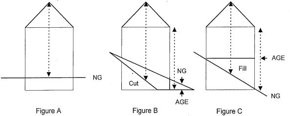
A. Where the natural grade remains unchanged the structure height is measured as by a plumb line from every point on the roof to the natural grade (NG). Natural grade means the existing grade prior to any human modification. See Figure A, above.
B. Where the natural grade has been cut at any point around the structure footprint, the structure height is measured as by a plumb line from every point on the roof to the altered grade elevation (AGE). See Figure B, above.
C. Where fill material has been added to the natural grade, the structure height is measured as by a plumb line from every point on the roof to the natural grade, regardless of height of fill. See Figure C, above. (Ord. 21-2015 § 16)
18.30.610 Eastsound urban growth area.
The San Juan County Comprehensive Plan Official Map shows the boundaries of the Eastsound urban growth area, and the limits of the subarea planning area. The Eastsound official map included in the plan is an excerpt from the Comprehensive Plan Official Map. (Ord. 21-2015 § 17)
18.30.620 General development standards.
The following standards implement the purposes and policies of the Eastsound plan appended to the County’s Comprehensive Plan. These standards apply to all development within the Eastsound subarea and within all land use districts except as specified below. (Ord. 21-2015 § 18)
18.30.630 Off-street parking.
A. Off-Street Parking – General Requirements.
1. Off-street parking shall be established prior to occupancy of any new or expanded building or before a change in the use of an existing building. Parking space requirements are determined from Table 22, following; and provided, that where the use is intensified, expanded or changed, there is a corresponding change in the number of spaces offered.
2. All permit applications required must include a parking layout plan consistent with the provisions of this section for the approval of the County engineer and director.
3. Off-street parking areas containing five or more spaces shall be landscaped as follows:
a. If parking spaces or access to parking fronts on a street, a screen strip at least three feet deep along the full length of the parking area fronting on the street shall be provided and shall include at least one tree, for each 30 feet of that frontage. If parking areas serving two or more adjoining properties are combined, perimeter screening and buffer requirements apply only to the perimeter of the entire area. Plant variety, size and spacing shall conform to standards in SJCC 18.30.670(D).
b. If a proposed parking area is not screened by buildings from views from the street or from adjacent property, a landscaped buffer strip at least five feet deep shall be provided along the entire length of the perimeter not screened (excluding any necessary curb cuts) and shall include a screen of plants, or a combination of plants and fencing, to include at least one umbrella shade tree for each 30 lineal feet of the landscaped strip.
c. Interiors of parking areas shall include at least 10 square feet of landscaping for each parking space, with landscaping located at least at aisle ends and corners. Aisle ends shall include curbed planters.
d. Landscaping materials shall be selected and maintained in accordance with provisions in SJCC 18.30.670(D).
4. Minimum dimensions for parking stalls shall be nine feet by 18 feet, six inches; except that parking areas for four or more cars may include up to 25 percent of required spaces designated for compact cars with minimum dimensions of eight feet by 15 feet. Any parking space allowed parallel to a wall or other structure shall be at least 10 feet wide. New off-street parking areas shall be designed so that public right-of-way is not used for circulation. Street access to off-street parking areas shall be at least 75 feet from the centerline of intersections unless no feasible alternative exists.
5. Minimum dimensions of driveways and aisles shall conform to those shown in Figure 1, below, unless an alternative design is approved in writing by the County engineer.
6. Individual parking spaces, except spaces serving single-family residences, shall be delineated by striping or by wheel stops.
7. Off-street parking spaces shall be located on the site of the use(s) served; provided, that off-site parking spaces associated with a use or uses within the village commercial district are allowed (as an allowable use) if the parking spaces are also located within that district or adjacent to it in the village residential/institutional district, and all of the following apply:
a. An easement or covenant guaranteeing use of the site for parking for the use(s) to be served for the life of the use(s), which shall run with the property, is recorded with County auditor after acceptance by the director;
b. The parking area is improved to comply with the standards for parking design required; and
c. The parking location is accessible to the site of the proposed use from a public path or street.
8. Donation of right-of-way for street improvements should be compensated by a credit to the property owner for each on street parking space resulting from the donation, against the number of spaces required for the use of the property. The parking credits equal the greater of the number of parking spaces created in the right-of-way or could have been otherwise created.
9. Where new or additional public on-street parking is provided in return for dedication of right-of-way the property owner shall receive credit for one space required under Table 22 for each space created as a result of the dedication.
10. All lighting shall be consistent with the provisions of SJCC 18.60.170.
11. The provision of shared parking consistent with SJCC 18.60.120(D)(1) through (5) is allowed.
B. Off-Street Parking – Village Commercial District Requirements.
1. Off-street parking within the village commercial district required for any new use or building shall be located at the side or rear of the use or building served: parking spaces required for expansion of an existing use or a change of use within an existing building in that district shall be located at the side(s) or rear of the building if possible. This requirement does not apply on lots less than 100 feet in width or where existing buildings would make it infeasible.
2. If the parking area is within the village commercial district but abuts the village residential/institutional district boundary, a view-obscuring barrier at least six feet high shall be provided at the district boundary; provided, that a lower barrier may be authorized if the director finds it adequate to screen commercial parking and structures from residential uses.
|
Net Use Building Area |
Minimum Parking Space Requirement |
|---|---|
|
A. Commercial Uses |
|
|
Banks and financial services: |
1 space per 300 square feet. |
|
Commercial and professional offices: |
1 space per 300 square feet. |
|
Retail establishments: |
1 space per 300 square feet. |
|
Retail establishments associated with substantial warehouse space (such as lumber yards) must have the inside storage building or warehouse area calculated separately from the retail requirements above: |
1 space per 1,000 square feet. |
|
Commercial storage space rental: |
1 space per 1,000 square feet, which may be located in front of the entrance door to storage units. |
|
Day care centers: |
1 space per employee (including owner/operator) plus an off-street drop off and pick up area. |
|
Resorts, hotels, motels, bed and breakfasts: |
1 space per guest unit. Additional spaces required for other uses (except residential associated with a B&B) contained within 1 space per 300 square feet. |
|
Restaurants, taverns and cocktail lounges: |
The greater of 1 space per 100 square feet of seating area within the building or 1 per 7 seats. Seasonal outside seating does not require additional parking spaces. |
|
B. Industrial Uses |
|
|
Automotive, boat, airplane and other machinery repair services: |
1 space per 1,000 square feet of indoor repair and storage area. |
|
Light industrial, warehouses and manufacturing facilities: |
1 space per 1,000 square feet. |
|
Utility equipment and service facility buildings: |
1 space per 1,000 square feet. |
|
C. Institutional Uses |
|
|
Retirement, convalescent and group homes: |
1 space per 600 square feet. |
|
Medical clinics: |
1 space per 200 square feet. |
|
Libraries: |
1 space per 300 square feet. |
|
Museums: |
1 per 800 square feet. |
|
Places of public assembly (includes theaters, auditoriums, churches, etc.): |
The greater of 1 space per 6 seats or 1 space per 90 square feet of only the principal assembly area. |
|
D. Residential Uses |
|
|
Dwelling units over 550 square feet per unit (single-family or multifamily): |
1.5 spaces per unit. |
|
Dwelling units 550 square feet or less per unit (single-family or multifamily): |
1 space per unit. |
Notes:
1. Parking requirements for any use not specifically mentioned above shall be determined by the director.
2. Standards are the minimum requirements and do not necessarily imply that the number of spaces required will be adequate to serve the peak parking needs of a particular use.
3. Space requirements based upon square footage are determined from net use area. For the purposes of calculating the number of spaces required based on net use area, the following is excluded from the gross floor area of a use or structure:
a. Circulation areas such as entries and weather vestibules, lobbies, hallways and corridors, stairways, elevators and similar areas which do not have customer/patron uses other than for circulation of people; and
b. Mechanical, custodial and storage areas such as mechanical rooms and chases/shafts, electrical/utility rooms and vaults, toilets, custodial rooms, and areas used solely for storage;
c. The area of structural and design elements is not excluded. In general, net use area should not include floor area which does not generate parking space demand by employees and customers or patrons.
Figure 1 – Parking Area Dimension Standards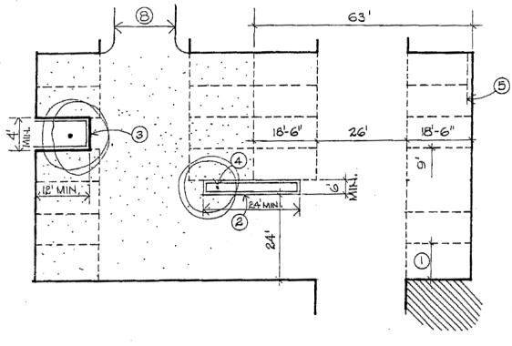
Notes:
1. End spaces shall be at least 10 feet wide when directly alongside a wall or building.
2. End aisles shall have a curbed planter.
3. In gravel areas, parking spaces shall be in groups of no more than four cars each, separated by a curbed planter, log, or other approved means.
4. Parking areas shall be landscaped as required including at least one tree per 10 cars.
5. Landscaping may encroach one foot if protected by a curb or bumper.
6. Angle parking is allowed if it conforms to the Highway Research Board Special Report No. 125, Parking Principles.
7. Barrier-free parking shall be provided in accordance with Chapter 11 of the International Building Code.
8. Minimum width for two-way driveways is:
a. One to six cars: 10 feet.
b. Seven to 12 cars: 16 feet.
c. 13 plus cars: 20 feet.
(Ord. 21-2015 § 19)
18.30.640 Payment in lieu – Eastsound village parking fund.
Repealed by Ord. 06-2022. (Ord. 21-2015 § 20)
18.30.650 Informational kiosks and mobile or semi-mobile structures.
A. Scope. The provisions of this section do not apply to activities on the publicly owned village green. Informational kiosks that are accessory to a conforming permanent structure on the same lot and only provide information are allowed in specific Eastsound land use districts. Retail kiosks are prohibited.
B. Regulations.
1. All informational kiosks shall:
a. Not have a footprint that exceeds 4.6 feet by seven feet;
b. Be considered as part of the net use area of the associated structure for the purposes of lot coverage and parking space calculation;
c. Not exceed a height of 10 feet at the highest point;
d. Not be closer than six feet from the nearest permanent structure;
e. Not use more than 40 square feet for displaying information;
f. Not block view corridors or pedestrian traffic;
g. Not remain in place for more than six months in a calendar year;
h. Be required to obtain all applicable permits;
i. Follow the setbacks that apply to the land use district and Eastsound design standards;
j. Have plans approved by the Eastsound design review committee (EDRC);
k. Not provide drive-through service;
l. Not impinge on existing parking spaces;
m. Provide a trash receptacle for users and employees;
n. Not provide amplified music;
o. Meet all appropriate codes for suspended or ground mounted electrical cords and/or electrical service; and
p. Be removed if abandoned or unused for three months.
2. Food vending trucks, if motorized, and fully mobile, are allowed if sited on private property and the use is consistent with the land use and development standard tables above.
3. Food vending trailers with detachable wheels, that are mobile or semi-mobile, are allowed if sited on private property and the use is consistent with the land use development standards tables above.
4. An informational kiosk is allowed if sited on private property and its use is consistent with the land use tables, development standard tables and design standards. (Ord. 21-2015 § 21)
18.30.660 Signs.
A. Scope. All signs, including sign structures and display areas or building walls with lettering on them, may be erected and maintained only as provided by this section; except for:
1. Signs owned and maintained by governmental agencies;
2. Signs inside a building, except for strobe lights or floating lights visible from a public right-of-way, private road or other private property; and
3. Signs carved into or part of materials which are an integral part of a building.
B. Regulations.
1. Placement of off-site outdoor advertising signs (A-frame) is allowed where highlighted in the public right-of-way in the locations shown on Figure 2 as described; at the intersection of Main Street and Lovers Lane, signs are allowed only on the west side of Lovers Lane; at the intersection of School Road and Prune Alley and the south side of the intersection of Terrill Beach Road and Crescent Beach Drive. No more than one sign per organization is allowed.
2. A-frame signs placed in these locations are subject to the provisions of SJCC 18.40.400(D), special event signs.
3. No sign shall be constructed, displayed or located in a manner that constitutes a public hazard.
4. Exterior signs that are illuminated from within or that move, flash or are otherwise animated are not allowed.
5. Freestanding signs are not allowed where they degrade or obstruct scenic views, nor exceed 12 feet in height above existing grade.
6. Canopies or awnings containing any text are regarded as signs for purposes of this section. Canopies or awnings illuminated from within, with or without text, are not allowed.
7. The County reserves the right to remove all nonconforming A-frame signs from the public right-of-way.
8. The required level of review for signs is as follows and, where applicable, signs are subject to policies, regulations and permit requirements of the Shoreline Master Program (SMP). If a permit is required by the Eastsound subarea plan or the SMP for a proposed use associated with a proposed sign, required applications shall be submitted and acted on together, in accordance with provisions of UDC.
a. Signs up to 10 square feet aggregate area per building are allowed outright.
b. Signs 11 to 32 square feet aggregate area per building are allowed subject to a provisional permit.
c. Signs larger than 32 square feet aggregate area/building require a conditional use permit.
In no case may they exceed one square foot per linear foot of primary building frontage.
9. No sign mounted on a building shall extend above the eave, rake or parapet of the wall on which it is mounted.
10. Only one way-finding sign is allowed within the Eastsound village green. This sign must conform to the following standards:
a. The sign may not be more than eight feet high;
b. The sign may not consist of more than four panels arranged around a central axis; each panel shall be no more than two feet wide and five feet high.
Figure 2 – Proposed Sign Locations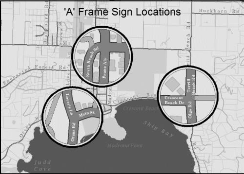
(Ord. 21-2015 § 22)
18.30.670 Design standards.
A. Eastsound Design Review Committee.
1. The Eastsound design review committee (EDRC) is appointed by the County council in three-year, staggered terms. The EDRC consists of three citizens and one alternate, whose legal residence is on Orcas Island, including at least one registered architect and one member of the Eastsound planning review committee (EPRC).
2. The EDRC meets by appointment and as needed to review specific project designs.
3. The EDRC may approve the design of projects that do not comply with the design standards in subsection (B) of this section, but which the EDRC determines meets the purpose and intent of the Eastsound subarea plan as expressed in this section and in the plan’s general goals and policies. The EDRC approval is limited to variation from the specific standards in subsection (B) of this section. All other provisions of the Eastsound subarea plan apply.
4. The EDRC’s written findings outline the specific reasons for any determination that a proposal does or does not meet the requirements of subsection (B) of this section. The EDRC submits its findings and conclusions to the director.
B. Design Standards.
1. Design Standards. Design standards apply to all buildings in the village commercial and village residential/institutional districts with the exception of single-family residences. The following standards apply except as specifically provided in subsection (C) of this section.
2. Walls of buildings in excess of 40 feet in length that front on a public street shall be broken with an offset or setback of at least four feet for every 40 feet. Roof planes shall have corresponding offsets.
3. Exterior wall surfaces shall be ship lap horizontal siding, cedar shingles, vertical or horizontal tongue and groove siding, board and batten siding, or rough-sawn textured panels with applied battens. However, other materials may be used for surface area, which does not exceed 10 percent of the total wall surface area of the building, for decorative details.
4. Roof slopes shall not be less than six to 12 nor more than 12 to 12 for the principal roof of a building. Secondary roofs of porches, dormers and appurtenances shall not be less than three to 12. Flat roofs are allowed but shall not be closer than 18 feet to any eave.
5. Sloped roof surfaces shall be cedar shakes, cedar shingles, composition shingles, or metal roofing. Color shall be subdued gray or an earth tone.
6. Any change from a single-family residential use of a dwelling unit to an allowed nonresidential use is exempt from these standards unless exterior structural alteration is required or proposed for the change of use.
C. Procedure for Exceptions to Design Standards.
1. Expansion or alteration of existing structures shall comply with the standards in subsection (B) of this section unless the applicant demonstrates that compliance would result in an inharmonious building design due to incompatible existing design features.
2. Applicants may request an exception to the design standards in subsection (B) of this section. The department will forward the request for an exception to the EDRC for review.
3. Applicants for an exception are encouraged to apply early in the design process to discuss and obtain tentative approval of the concept and the terms of the exception. Final approval is subject to a review of construction documents submitted for a building permit to ensure the original concept and terms have been adhered to.
4. EDRC decisions may be appealed to the director.
Figure 3 – Design Standards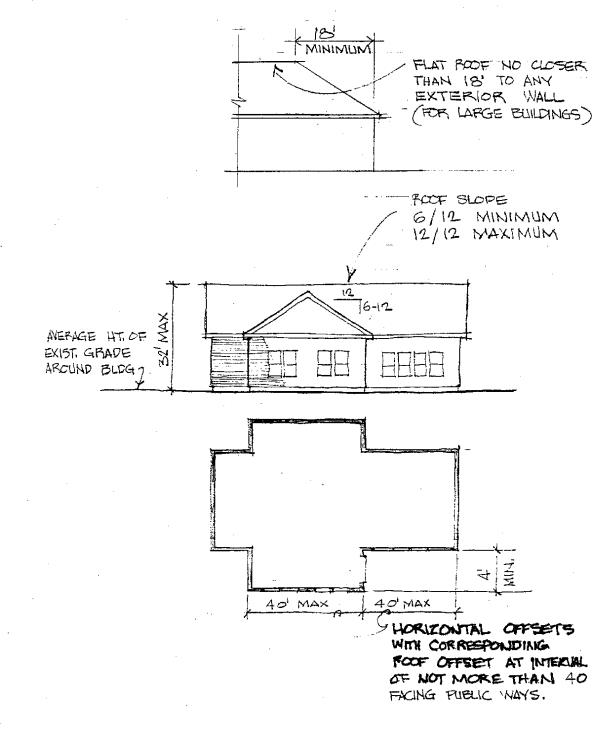
D. Landscaping. Landscaping required by the Eastsound subarea plan shall be designed, installed and maintained in conformance with the following provisions:
1. Types. Landscaping required by this plan is one of the following three types.
a. Screening. Screening is to provide a visual barrier at least five feet high. When screening is specified, landscaping shall generally consist of a mix of evergreen groundcovers, trees and shrubs. Shrubs shall be at least two feet tall at the time of planting and, if shrubs (or hedges) are to provide the majority of the screen, shall have a minimum height of five feet at maturity. Trees shall be at least four feet tall at the time of planting and all plants shall be spaced so as to grow together within three years of planting to achieve a sight-obscuring screen of at least 80 percent opacity. Required screening shall be at least five feet deep. Existing vegetation, walls, fences or grading (maximum slope three to one) may be incorporated into the design of the screen if they contribute to the intent of this requirement.
b. Landscaped Buffers. A buffer is a separation, but not necessarily a visual barrier. When landscaped buffers are specified, landscaping shall generally consist of a mix of evergreen and deciduous groundcovers, trees and shrubs, chosen and spaced to cover the buffer area within three years of planting. However, buffers required along public streets shall consist of walkways, groundcovers, shrubs and deciduous trees only. Buffers shall be at least eight feet wide for the length required unless specified otherwise in the Eastsound subarea plan. Deciduous trees shall have a minimum trunk diameter of one and one-half inches at planting and be spaced so that branches will touch after 10 years of normal growth. Along public streets such buffers shall include at least one tree for every 30 feet of lineal street frontage. Existing vegetation, walls, fences or grading (maximum slope three to one) may be incorporated into the design of the buffer if they contribute to the intent of this requirement.
c. Open Space Landscaping. Open space may be natural or landscaped including grass, paved walkways and open decks, but does not include parking areas or driveways. Ten square feet of open space is required.
2. Maintenance. The property owner and any tenant is responsible for maintenance of all landscaping required by the Eastsound subarea plan, which shall be maintained in good condition so as to present a healthy appearance. All landscaped areas required by the Eastsound subarea plan shall be provided with a readily available water supply. Tree limbs are not allowed to extend over walkways or driveways below a height of eight feet above grade.
3. Plant Selection. Plant varieties selected to fulfill requirements of the Eastsound subarea plan shall be of a type suitable to the climate and site conditions.
Where the director determines a proposed landscaping plan will not meet screening and buffer development standards in subsection (D)(1) of this section, the director may require that plant lists and design for required landscaping be reviewed or prepared by a landscape architect. (Ord. 21-2015 § 23)
18.30.680 Standards for new and substantially altered development.
A. Applicability. The regulations in this section apply to all new development and all substantial alterations within the urban growth area (UGA). A substantial alteration is where the total cost of all alterations (such as electrical, mechanical, plumbing, and structural changes) for a building or facility within any 12-month period or single development permit application amounts to 50 percent or more of the value of the building or facility. In determining the current value of the building or facility, the assessor’s fair market value, or a current appraisal by a qualified professional, may be used.
B. General Regulations. See SJCC 18.60.240. (Ord. 21-2015 § 24)
18.30.690 Exterior lighting.
Exterior lighting shall be energy-efficient and shielded or recessed so that direct glare and reflections are contained within the boundaries of the lot. Exterior lighting shall be directed downward and away from adjoining properties and public rights-of-way. No lighting shall blink, flash, or be of unusually high intensity or brightness. All lighting fixtures shall be appropriate in scale, intensity, and height to the use they are serving. Any lighting installed in parking areas shall be of direct cutoff design so that the source is not visible from adjacent property. Decorative lighting shall be limited to incandescent lamps with a maximum of 25 watts per bulb and 500 watts overall. An exception to the exterior lighting standards applies to holiday lighting between October 15th and February 15th. (Ord. 21-2015 § 25)
18.30.700 Street development standards.
A. Existing public streets shall be improved to comply with the configurations specified in Figures 4 through 6.
B. Curbs, gutters, sidewalks, power conduits, power pods, and street trees are required for streets within the village commercial and village institutional districts and shall comply with all standard details.
C. The County will provide curbs, gutters, sidewalks and street trees when public street improvements are made and sufficient right-of-way exists. If the right-of-way is insufficient the County will make these improvements if the necessary right-of-way is dedicated. If property owners are unwilling to dedicate right-of-way the County may choose to forgo curbs, gutters, sidewalks, and street trees, or use some other means of financing curbs, gutters, sidewalks and street trees such as LID, grants, local funds, etc.
D. When the County improves a street with insufficient right-of-way, curbs, gutters, sidewalks and street trees will be installed when property owners dedicate appropriate right-of-way. The County council may adjust street improvement standards required by the Eastsound subarea plan by adopting an improvement plan for a specific street.
E. Property owners shall install, or agree to install at a future date under specific conditions, curbs, gutters, sidewalks and street trees when their property adjoining public streets is developed, when an existing use is substantially expanded, when a change of use occurs, or when improvements of a fair market value of at least $50,000 are made to the property. The department of public works is responsible for establishing the grades at the street sufficient to determine the proper location of the improvements called for in this subsection so that they will be in alignment with future street improvements. If public works has not completed a design for the street or cannot furnish the necessary information, the improvements shall not be required until such time as public works has established the necessary grades and design standards for the required improvements. As a part of any agreement to install improvements at a future date the property owner shall agree to participate in a street improvement program for the entire street when it is implemented.
F. New public street rights-of-way shall be at least 60 feet wide in Eastsound and at least 50 feet wide within the village commercial or village residential/institutional land use districts.
G. Street trees should be located as illustrated in Figure 6. On any given street, species of large shade trees and flowering ornamental trees should be uniform, and selected by agreement of a simple majority of the affected property owners, unless a specific species has been selected as part of an adopted plan for improvements to a particular street. Table 23 contains a list of suggested trees.
H. Maintenance agreements for street accessories (street trees, sidewalks, landscaping, etc.) is required prior to occupancy of any new or substantially expanded use and as a condition of participation in any street improvement program as provided for in this section.
I. Standard Plans. In accordance with subsection (D) of this section, the following standard plans shall apply to the County roads, or portions thereof, as may be specifically identified in each standard plan:
|
Series Name |
Plan Number |
Revision Date |
|---|---|---|
|
Eastsound’s Madrona Point |
09-30.01 |
2018.03.06 |
|
Eastsound’s Madrona Point |
09-30.02 |
2018.03.06 |
J. Deviations. The County engineer shall administer the application of the standard plans adopted in subsection (I) of this section to County roads. The County engineer may submit requests for minor technical deviations to the County council for approval by motion. Said requests shall be accompanied by engineering justification prepared by a licensed professional civil engineer. Financial constraints by and of themselves do not constitute a variance justification.
Figure 4 – Streetscape Options for 30' R.O.W. 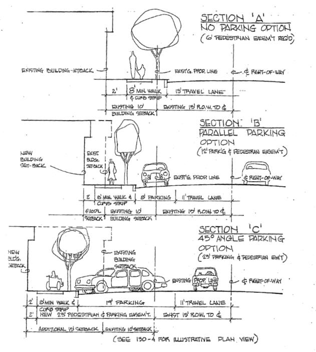
Figure 5 – Streetscape Options for 50' R.O.W.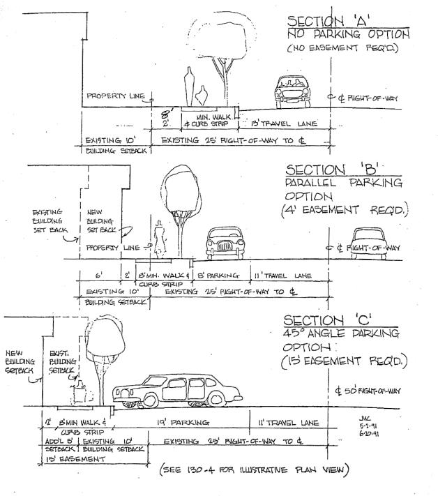
Figure 6 – On-Street Parking Options with Curb, Road, Tree, Curb Strip,
Sidewalk, and Setback Standards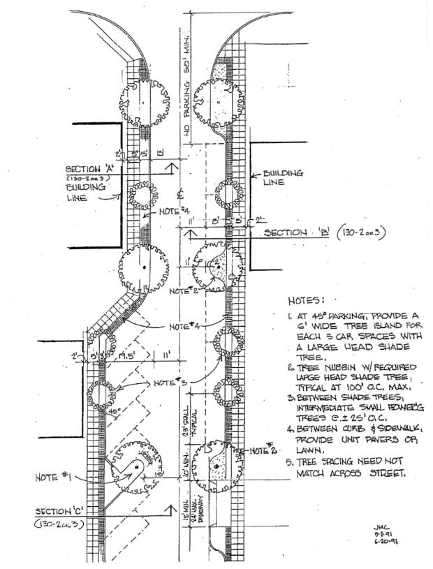
Figure 6 illustrates where street trees are to be located. On any given street within the village commercial district, large shade trees and flowering trees shall be uniform. The following are suggested appropriate trees:
|
Large-Head Shade Trees: |
|
|
Acer sacarum |
Sugar Maple |
|
Aescules hippocastrum |
Horse Chestnut |
|
Quercus rubra |
Red Oak |
|
Quercus palustrus |
Pin Oak |
|
Tillia cordata |
Linden, Basswood |
|
Sorbus aucuparia |
Mountain Ash |
|
Flowering Trees: |
|
|
Crataegus oxycantha |
Hawthorn |
|
Malus floribunda |
Crabapple – Fruitless |
|
Prunus blireiana |
Plum |
(Ord. 9-2018 §§ 2, 3; Ord. 21-2015 § 26)
Article IX. Lopez Village Subarea Plan
18.30.710 Applicability of this article.
A. This article provides specific land use regulations and development standards for the Lopez Village urban growth area which are intended to implement the goals and policies of the Lopez Village subarea plan, a component of the San Juan County Comprehensive Plan.
B. Where subarea specific regulations or development standards are not established, applicable regulations in this title apply.
C. In cases of a conflict, the goals and policies of the Lopez subarea plan and specific regulations of this article prevail. (Ord. 11-2019 § 11)
18.30.720 Lopez Village planning review committee.
A. The Lopez Village planning review committee is established by the county council.
B. The Lopez Village planning review committee will consist of five members, all residents of Lopez Island appointed by the county council for terms of three years each so that terms of all members do not coincide. Terms of one member will be for one year from the date of adoption of the ordinance codified in this chapter and the terms of two members will be for a period of two years from the anniversary of the date of adoption and two for three years from the anniversary of the date of adoption.
C. The purpose of the Lopez Village planning review committee is to advise the department, planning commission and the County council on land use and development matters affecting the Lopez Village urban growth area.
D. The Lopez Village planning review committee has the authority to:
1. Review the Lopez Village subarea plan and development regulations at least once every five years from the date of adoption. The Lopez Village planning review committee may recommend amendments following SJCC 18.90.050 to more effectively achieve the purposes and policies of the Lopez Village subarea plan;
2. Provide early design guidance to persons proposing development in the Lopez Village urban growth area;
3. Review and provide comments to the director on proposed development and project permit applications, and environmental determinations issued according to the State Environmental Policy Act for proposed developments in the Lopez Village urban growth area;
4. Monitor applications and permits for development within Lopez Village urban growth area to enable effective implementation of the Lopez Village subarea plan;
5. Hold regular meetings with County representatives and utility providers for the exchange of information about plans for the extension of services or improvements to facilities within Lopez Village subarea plan;
6. Address parking issues or may establish a parking subcommittee;
7. Make recommendations to the director regarding the intent or meaning of the provisions of the Lopez Village subarea plan or development regulations affecting Lopez Village urban growth area; and
8. Fulfill the above responsibilities or other responsibilities directed by County council in accordance with bylaws for conduct for committees adopted by the County council. (Ord. 11-2019 § 12)
18.30.730 Lopez Village urban growth area densities, and density bonuses.
A. The base density in the Lopez Village residential designation is up to six dwelling units per acre. The village commercial designation has no base density.
B. All development subject to this section that is not served by the existing public sewage treatment system:
1. Must have sewer capability that meets the design specifications of the sewer district systems for later connection; and
2. Must connect to the established urban growth area sewer district within one year of such service becoming available to the development.
C. All development subject to this section that is not served by a designated community Class A water system must connect to one within one year of such service becoming available to the development.
D. For all development subject to this section, the applicant must execute and record with the auditor a statement, binding on the owner, successors, heirs, and assigns, which provides that the owner will not object to the formation of a utility local improvement district for water or sewer.
E. Development and associated improvements and structures must be located on the property in the village residential designation so that they must not preclude future potential development at a minimum density of six units per acre.
F. Land divisions in the village residential designation must provide remainder lots that will allow an average density with the division of six units per acre or greater. The following note must be on the face of the plat of all subdivisions and short subdivisions and on all deeds filed as part of an exempt division:
This land division is located within an urban growth area. This land division has been designed in a manner to allow the future redivision to achieve an average density of six homes per acre.
G. Development applications are exempt from the requirements of subsections (E) and (F) of this section where:
1. Commercial development is within the village commercial designation.
2. Residential development will achieve a residential density of six units per acre or greater in the village residential designation.
3. Development is within the village commercial and village institutional designations that do not require planning to maintain the potential to develop a residential density of six units per acre or greater.
H. A density increase of up to a maximum of 12 units per acre may be approved for a residential development in the village residential designation provided an application for a planned unit development required by SJCC 18.80.160 and the development satisfies the requirements of SJCC 18.60.220.
I. A two-unit-per-acre density bonus may be approved if water conservation features are included in the design of the project and the applicant can demonstrate that the water conservation features will reduce demand by 15 percent from the water purveyor’s average annual usage for each equivalent residential unit.
J. A two-unit-per-acre density bonus may be approved if a minimum of two affordable housing units are provided; a three-, four-, five- or six-unit-per-acre density bonus may be approved if a minimum of three, four, five or six affordable housing units are provided. Affordable housing for this section means perpetual affordability for households with moderate income and below as defined by SJCC 2.27.020(C). See SJCC 18.60.260.
K. The density bonus for affordable housing and the density bonus for water conservation may be combined to provide a maximum density bonus of six units per acre, which when combined with the underlying density of six units per acre would result in a maximum of 12 units per acre. (Ord. 11-2019 § 13)
18.30.740 Lopez Village urban growth area resource buffer.
A. A resource buffer of at least 50 feet must be maintained from the boundary of any property designated on the official map as agricultural resource land.
B. New structures for a residential or commercial occupancy that provides lodging or food service to visitors are not allowed within the resource buffer. (Ord. 11-2019 § 14)
18.30.750 Allowed and prohibited uses in Lopez Village urban growth area.
Allowable and prohibited uses in Lopez Village urban growth area are established in Table 18.30.750 below, except as modified by SJCC 18.60.220(D) for planned unit developments.
|
How to Use This Table This table displays Lopez Village urban growth area land use designations and classifies uses allowed and prohibited uses. The information in the table is modified by the table footnotes and the following bullets: • A location may have a multiple designation; such as when the Shoreline Master Program (SMP) or another overlay district applies to the location. Shoreline jurisdiction designations use some of the same names as the uplands land use designations; however, where allowable uses differ between the uplands and shorelines designations, compliance with the SMP is also required. • All regulations in this code apply to the uses and activities listed in these tables. To determine whether a particular use or activity can occur in a land use designation and location, all relevant regulations must be consulted in addition to this table. Lopez Village urban growth area land use designations VC = Village commercial VR = Village residential VI = Village institutional Categories of Uses Y = Uses allowed outright (i.e., without a project permit), subject to applicable development standards. If a building or other construction permit is required, this use is subject to administrative consistency review; see SJCC 18.80.070. P = Provisional use (a project permit), subject to the applicable development standards, public notice, and permit processing procedure. P/C = After review of SJCC 18.80.090 and Table 8.2, the director will determine whether a provisional or conditional use permit will be required. C = Conditional use (a project permit), subject to public notice and permit hearing procedure; see SJCC 18.80.100. N = Uses that are prohibited. |
|
Land Use |
Lopez Village1, 2, 3 |
||
|---|---|---|---|
|
VC13 |
VI |
VR12 |
|
|
Commercial Uses |
|||
|
Animal shelters and kennels |
P |
N |
N |
|
Artisan activities |
Y |
N |
N |
|
Auto fuel service stations and repair services |
Y |
N |
P |
|
Bed and breakfast inn |
Y |
N |
P/C |
|
Bed and breakfast residence |
Y |
N |
P |
|
Brewery, distillery, wine and mead-making |
Y |
N |
N |
|
Camping facilities |
N |
N |
N |
|
Day care (1 – 6 children) |
Y |
Y |
C |
|
Day care (7 or more children) |
P |
Y |
N |
|
Day care/health, adult (1 – 8 adults) |
Y |
Y |
C |
|
Family daycare provider – up to 12 children in the provider’s family living quarters |
Y |
Y |
Y |
|
Drinking establishment (no drive through) |
Y |
N |
N |
|
Eating establishment (no drive through) |
Y |
N |
N |
|
Hostel |
Y |
Y |
C |
|
Hotel/motel |
Y |
N |
N |
|
Indoor entertainment facility4 |
C |
C |
N |
|
Mobile food vending units |
Y |
Y |
N |
|
Nursing homes |
Y |
Y |
P |
|
Personal and professional services |
Y |
P |
N |
|
Personal wireless service facilities, colocated on an existing, permitted stand-alone tower, or mounted to the surface of an existing structure |
P |
P |
C8 |
|
Personal wireless service facilities mounted on a building which meets the height standards of the land use designation, or facilities camouflaged or disguised as an allowable exemption to the height standard |
P |
P |
C8 |
|
Personal wireless service facilities, other |
C |
P |
N |
|
Resorts and camps, new |
N |
N |
N |
|
Retail sales and services |
Y |
N |
N |
|
Farmers market |
Y |
Y |
N |
|
Warehouse, mini-storage, and moving storage facilities |
N |
N |
N |
|
Unnamed commercial uses |
C |
N |
N |
|
Industrial Uses |
|||
|
Bulk fuel storage facilities |
N |
N |
N |
|
Concrete and concrete batch plants |
N |
N |
N |
|
Construction contractor yards and offices16 |
Y |
N |
N |
|
Feedlots |
N |
N |
N |
|
Garbage and solid waste transfer stations |
N |
N |
N |
|
Heavy equipment rental services |
N |
N |
N |
|
Heavy industrial |
N |
N |
N |
|
Light industrial |
N |
N |
N |
|
Light manufacturing that has no more impacts from vibrations, noise and odor than general office use |
P |
N |
N |
|
Lumber mills, stationary |
N |
N |
N |
|
Marijuana production and processing, Tiers 1 and 2 |
N |
N |
N |
|
Marijuana production and processing, Tier 3 |
N |
N |
N |
|
Outdoor storage yards |
N |
N |
N |
|
Reclamation of mineral extraction sites |
N |
N |
N |
|
Recycling collection/processing |
N |
N |
N |
|
Recycling collection |
P |
N |
N |
|
Resource processing accessory to extraction operations |
N |
N |
N |
|
Mining and mineral extraction activities |
N |
N |
N |
|
Wholesale distribution outlet |
N |
N |
N |
|
Wrecking and salvage yards |
N |
N |
N |
|
Unnamed industrial uses |
N |
N |
N |
|
Institutional Uses |
|||
|
College or technical school/adult education |
P |
Y |
N |
|
Community club or community organization assembly facility |
Y |
Y |
N |
|
Emergency services |
P |
P |
N |
|
Government offices |
Y |
Y |
N |
|
Institutional camps |
N |
P/C |
N |
|
Library |
Y |
Y |
N |
|
Museum |
Y |
Y |
N |
|
Post office |
Y |
Y |
N |
|
Religious assembly facility |
P |
Y |
N |
|
School, primary and secondary |
Y |
Y |
N |
|
Unnamed institutional uses |
C |
C |
C |
|
Recreational Uses |
|||
|
Camping facilities in public parks |
N |
N |
N |
|
Indoor recreation facilities |
Y |
Y |
N |
|
Outdoor recreation development, low impact5 |
P |
P |
C |
|
Parks, low impact5 |
P |
P |
C |
|
Playing fields, low impact5 |
N |
N |
N |
|
Recreational vehicle parks |
N |
N |
N |
|
Outdoor shooting ranges |
N |
N |
N |
|
Unnamed recreational uses |
C |
C |
C |
|
Residential Uses6 |
|||
|
Cottage enterprise |
Y |
N |
P |
|
Farm worker accommodations |
N |
N |
N |
|
Farm stay |
N |
N |
N |
|
Home occupation |
Y |
N |
Y |
|
Multifamily residential units (3+ units) |
Y |
P14 |
Y |
|
Single-family residential unit, stand-alone |
N |
N |
Y |
|
Single-family residential (1 unit only) or accessory apartment (1 unit only), accessory to an allowable nonresidential use |
Y |
Y |
Y |
|
Two-family residential (duplex), stand-alone |
N |
N |
Y |
|
Live-work units7 |
Y |
N |
N |
|
Unnamed residential uses |
C |
N |
C |
|
Vacation rental of residence or accessory dwelling unit |
Y |
N |
P |
|
Transportation Uses |
|||
|
Airfields |
N |
N |
N |
|
Airports |
N |
N |
N |
|
Airstrips |
N |
N |
N |
|
Hangars |
N |
N |
N |
|
Helipads associated with a medical clinic |
Y |
Y |
N |
|
Ferry terminal |
C |
N |
N |
|
Parking lots |
C |
N |
N |
|
Parking structures |
N |
N |
N |
|
Streets, public |
Y |
Y |
Y |
|
Trails and paths, public |
Y |
Y |
Y |
|
Unnamed transportation uses |
P/C |
P/C |
N |
|
Utility Uses |
|||
|
Commercial communication facilities 8 |
C |
N |
N |
|
Commercial power-generation facilities |
C |
C15 |
N |
|
Community sewerage treatment facilities |
P/C |
N |
N |
|
Category “A” joint use wireless facility9 |
P/C |
P/C |
P/C |
|
Category “B” joint use wireless facility |
P/C |
P/C |
P/C |
|
Storage and treatment of sewage, sludge and septage systems other than lagoons |
C |
C |
C |
|
Utility distribution lines |
Y |
Y |
Y |
|
Utility facilities |
Y |
Y |
Y |
|
Utility substations |
N |
N |
N |
|
Utility transmission lines |
N |
N |
N |
|
Water storage tanks, community |
P/C |
P/C |
P/C |
|
Water treatment facilities |
C |
C |
C |
|
Desalination facilities |
C |
C |
C |
|
Unnamed utility uses |
C |
C |
P/C |
|
Agriculture and Forestry Uses |
|||
|
Agricultural activities |
Y |
Y |
Y10 |
|
Forest practices, no processing11 |
N |
N |
Y |
|
Lumber mills, portable may be temporary |
Y |
N |
P |
|
Nurseries (retail only) |
Y |
N |
N |
|
Small-scale slaughterhouses |
N |
N |
N |
|
Unnamed agricultural and forestry uses |
C |
N |
C |
Notes:
1. All uses must be consistent with the goals and policies of the land use designation in which they are proposed to occur, the Land Use Element of the Comprehensive Plan, and the Lopez Village subarea plan.
2. A land use or development proposed to be located entirely or partly within 200 feet of the ordinary high water mark of a regulated shoreline is within the jurisdiction of the Shoreline Master Program, and is subject to the applicable provisions of Section 3 of the Comprehensive Plan and Chapter 18.50 SJCC, as well as the applicable provisions and permit requirements indicated in this table. Please refer to Chapter 18.50 SJCC for specific use regulations and regulations by shoreline environment; see also SJCC 18.80.110 for shoreline permit requirements.
3. Overlay districts provide policies and regulations in addition to those of the underlying land use designations for certain land areas and for uses that warrant specific recognition and management. For any land use or development proposed to be located entirely or partly within an overlay district, the applicable provisions of the overlay district must prevail over any conflicting provisions of the UDC.
4. Indoor entertainment facilities may not exceed 6,000 square feet in area.
5. Low impact facilities must not include stadium lighting, permanent goalposts, grandstands, concession stands, or artificial turf.
6. Owners or persons responsible for any horse, sheep, swine, donkey, goat, or other grazing animal must not allow the animal to go at large in any public road or place. Such animals may only be housed on lots that are five acres or larger. Roosters must not be allowed in the Lopez Village urban growth area.
7. When associated with a mixed-use building, the residential unit or units must be located on the second floor to allow commercial development on the bottom floor, except that residences may be placed behind the commercial portion of the building on the first floor. The residential floor area cannot exceed 50 percent of the total floor area of the structure.
8. To minimize commercial developments on lands designated village residential, wireless facilities other than joint use wireless facilities must be accessory to a legal conforming or nonconforming structure and cannot be the primary land use.
9. Facilities are subject to the requirements for joint use wireless facilities in Chapter 18.40 SJCC.
10. Agricultural activities are allowed except for “agricultural processing, retail and visitor serving facilities for products” in the village residential designation.
11. Forest practices including timber harvesting, except for Class IV General, are regulated by the Washington Department of Natural Resources (see SJCC 18.40.120 through 18.40.180).
12. In Lopez Community Land Trust planned developments, small-scale agricultural activities, commercial uses, home occupations, and cottage industries are allowed.
13. Commercial businesses must be operated in a way that will prevent unreasonable disturbance to area residents and that complies with San Juan County Code. No use of the property must be made that produces unreasonable vibration, noise, dust, smoke, odor or electrical interference to the detriment of adjoining properties.
14. Multifamily housing in the village institutional designation is only allowed for affordable housing projects as defined by SJCC 2.27.020(C).
15. Only solar arrays are allowed in the village institutional designation.
16. Parking of service vans and company cars is allowed. Outdoor storage of heavy equipment such as excavators, bulldozers, dump trucks, and road graders is not allowed in the village commercial designation. Outdoor storage areas may not exceed 1,000 square feet and must not be visible from public roads and the shoreline. Screening must be no less than five feet high consisting of fencing, vegetation or other visual screening materials. (Ord. 11-2020 § 5; Ord. 11-2019 § 15)
18.30.760 Lopez Village urban growth area setbacks and dimensional standards.
|
Development Standard |
Land Use Designation |
||
|---|---|---|---|
|
Village Commercial |
Village Institutional |
Village Residential |
|
|
Setbacks1 – 6 |
|||
|
Front or Road3,4,5 |
In Block A of the Lopez Village Association PUD: Maximum of five feet6 Other areas: Minimum of five feet |
Minimum of five feet |
Minimum of five feet |
|
Side |
IRC or IBC* As applicable |
IRC or IBC* As applicable |
IRC or IBC* As applicable |
|
Rear |
Minimum of ten feet |
Minimum of ten feet |
Minimum of ten feet |
|
Rear – for Lopez Village Association Plat Block A and lots 21 – 23 in the village commercial designation |
IRC or IBC* As applicable |
NA |
NA |
|
Maximum Building Dimensions and Impervious Surface |
|||
|
Maximum building footprint per building7, 8 |
Eight thousand square feet |
Eight thousand square feet |
Three thousand square feet |
|
Height 9 |
Thirty-five feet |
Thirty-five feet |
Thirty-five feet |
|
Maximum impervious surface10, 11 |
Eighty-five percent |
Eighty-five percent |
Forty percent |
* IRC: International Residential Code. IBC: International Building Code.
Notes:
1. Fences are exempt from setback requirements, except when they impair sight lines at intersections, as determined by the County engineer.
2. Setbacks do not apply to mailboxes, wells, pump houses, bus shelters, septic systems and drainfields, landscaping (including berms), utility apparatus such as poles, wires, pedestals, manholes, water pipes, water valves and vaults, at grade walkways, patios and driveways, and other items as approved by the director.
3. Setbacks from roads must be measured from the margin line of the road right-of-way. This measurement must be to a line parallel to and measured perpendicularly from the appropriate line. Side and rear setbacks are measured from the edge of the property in the same manner as street setbacks.
4. The maximum front or road setback may be reduced in village commercial district by the director after a recommendation is received from the Lopez Village planning review committee. The criteria for administrative approval may include unique topographical circumstances, minimization of environmental or cultural resource impacts, or greater compatibility with existing development and design features.
5. Road right-of-way setbacks may be waived, by the director after a recommendation is received from the County engineer, when the presence of shoreline setbacks, property lines, topography, or other restrictions make it unreasonable to construct a structure without encroaching into the road right-of-way setback.
6. Entry features such as sheltered entrances and covered decks and gathering spaces are exempt from this requirement.
7. The building footprint will be determined by the horizontal area enclosed by the exterior wall line and contiguous roofline excluding porches and decks that extend no more than 10 feet from the exterior wall line that is closest to the average or natural grade.
8. Porches and decks that extend more than 10 feet from exterior wall line or exceed 300 square feet in area cumulatively will be included in overall footprint except for those used as gathering spaces.
9. Chimneys, smokestacks, fire or parapet walls, ADA-required elevator shafts, flagpoles, utility lines and poles, skylights, communication sending and receiving devices, HVAC and similar equipment, and spires associated with places of worship are exempt from height requirements.
10. Green roofs and pervious pavement will not be included in calculations of impervious surface for the purposes of this table.
11. The maximum impervious surface requirement applies to all parcels in the Lopez Village urban growth area except for the Lopez Village Association PUD Block A. Block A is allowed 100 percent full buildout. (Ord. 11-2019 § 16)
18.30.770 Fences.
Fences in Lopez Village urban growth area may be up to eight feet in height. Only the bottom three feet of the fence may be made of solid construction. The remainder of the fence should allow light and air flow. (Ord. 11-2019 § 17)
18.30.780 Artisan activities.
Artisan activities must:
A. Be conducted in buildings that are 2,500 square feet in area or less which offer retail sales;
B. Be located on or developed to provide visual buffers such as landscape or fencing between outdoor activities and roads, except for outdoor patios used for food and beverage service;
C. Not use equipment or material which produces vibration, noise, dust, smoke, odor, or electrical interference to the detriment of adjoining property; and
D. Employ or contract with no more than the equivalent of six full-time persons. No more than nine employees must be on site at one time. (Ord. 11-2019 § 18)
18.30.790 Hostels.
A. The owner or lessee of the hostel must provide notice to the guests regarding rules of conduct and their responsibility.
B. Owners of hostels must file a 24-hour contact phone number with the department and County sheriff.
C. Hostels must provide bicycle parking facilities that comply with SJCC 18.60.130.
D. Hostels must utilize shared parking options when feasible as permitted by SJCC 18.30.960.
E. Parking standards may be modified by the director upon approval of an alternative parking plan.
F. For every six beds in a shared-room, a hostel may rent one room for private accommodation. (Ord. 11-2019 § 19)
18.30.800 Mobile food vending units.
Mobile food vending units:
A. Are allowed in the village commercial and village institutional designations in accordance with SJCC 18.30.750.
B. Are allowed as a temporary event in the village residential designation per SJCC 18.80.060.
C. May be located on private or public property except as prohibited by the street vending regulations in Chapter 5.08 SJCC.
D. Must comply with the County’s food service health regulations in Chapter 8.04 SJCC and state health regulations in Chapter 264-215 of the WAC.
E. Must be placed at least five feet from driveways, sidewalks, utility boxes, accessibility ramps, and building entrances or exits. (Ord. 11-2019 § 20)
18.30.810 Live-work units in the village commercial designation.
A. A proposed mixed-use concept plan in the village commercial designation must be submitted to DCD prior to a required preapplication meeting.
B. Multiple live-work units may occur in one structure. (Ord. 11-2019 § 21)
18.30.820 Signs.
A. The following signs are exempt from the regulations contained in subsections (B) through (D) of this section:
1. Signs required by law, and flags of national and state governments.
2. “No Hunting” and “No Trespassing” signs smaller than two square feet in area.
3. Political signs.
4. Special event signs for periods not to exceed 30 total days in a calendar year in the village commercial and institutional designations.
5. Public notice signs.
6. Traffic signs and traffic control devices and signals.
7. Temporary holiday decorations.
8. One temporary construction sign of up to 15 square feet in area for a period not to exceed 12 consecutive months.
9. House numbers.
10. Temporary garage sale signs posted for a period not to exceed four days.
B. Exterior signs in all Lopez Village urban growth area designations may include indirect or bare-bulb lighting sources that do not produce glare. They must not:
1. Be illuminated from within including digital, LED or neon components; or
2. Include moving, flashing parts, or moored balloons or other floating components tethered to the ground or structure.
C. The following general sign regulations apply to signs in the village commercial and village institutional designations:
1. Signs must be related to a business, service, or event within Lopez Village urban growth area.
2. Except for multitenant properties regulated by subsection (C)(11) of this section, each building or land use activity is allowed three signs.
3. The maximum size of any sign in village commercial and institutional designations is 15 square feet in area.
4. Signs must be oriented toward pedestrian trails or abutting roads.
5. Window signs made of opaque materials that obscure views into and out of the window are prohibited.
6. Awnings and canopies with letters, wording, or symbols are considered signs. Signs on awnings and canopies must be on the valance, the portion parallel to the window. Internal illumination of awnings and canopies is prohibited unless they are concealed in a way to provide directional light needed to illuminate sidewalks or storefronts.
7. Projecting signs must be mounted perpendicularly to a building or column and allow eight feet of overhead clearance above public walkways. Projecting signs may be up to six square feet in area.
8. Signs mounted on a building must not extend above or beyond the eave, rake, or parapet of the wall on which it is mounted.
9. Wall-mounted signs must not project more than six inches from the building wall. The size of signs painted on buildings must be measured by the smallest polygon enclosing the letters and symbols of the sign.
10. One of the three signs allowed in subsection (C)(2) of this section may be a freestanding sign. One freestanding sign no taller than six feet is permitted per lot. Freestanding signs must be placed near the public right-of-way where feasible and may not obstruct pedestrian pathways.
11. On multitenant properties, a master signage plan must be developed for review by the director and Lopez Village planning and review committee. If used, a multitenant sign must group signage for the tenants in a single unified design. The multitenant sign must count towards one of two signs allowed per tenant. A multitenant sign may be up to 15 square feet in area. Other tenant signs may be up to six square feet in area. The master signage design must be submitted to the director who will forward the plan to the Lopez Village planning and review committee to request a review and recommendation.
12. Off-premises signs are prohibited, except as allowed below:
a. Temporary off-premises, outdoor commercial signs such as A-frame sandwich boards are permitted for a maximum of five consecutive days on designated sign pads in the public right-of-way at the following intersections:
i. Southwest corner of Weeks and Fisherman Bay Roads;
ii. Northwest corner of Lopez and Fisherman Bay Roads; and
iii. Northwest corner of Lopez and Village Roads.
Figure 18.30.820. Permitted Locations for Outdoor Commercial Signs
b. Directional signs that provide direction to geographical places (e.g., Spencer Spit) or other public destinations are allowed in Lopez Village urban growth area if they are:
i. No larger than four inches by 24 inches in area and sited at intersections; or
ii. No larger than six inches by 42 inches in area if located in a public park or County land bank preserve; or
iii. Part of an island-wide sign program approved by the County council or County engineer.
D. When allowed, signs in the village residential designation must comply with the following:
1. One sign up to two square feet in area is permitted to advertise or identify a home occupation, or cottage industry. It may not be internally illuminated or made of reflective materials.
2. The sign may be mounted on the residence or freestanding. Freestanding signs may not be placed higher than three feet above grade.
E. Deviations from these sign regulations may be allowed subject to the following:
1. A written proposal must be submitted to the director that identifies the code section proposed to be varied, the purpose and need for the deviation including any geographical, topographical, or existing development conditions that support a change.
2. The director will forward the proposal to the Lopez Village planning and review committee to request a review and a recommendation.
3. The director will consider the Lopez Village planning and review committee’s recommendation and make a decision regarding the proposal after considering site and development circumstances. (Ord. 11-2019 § 22)
18.30.830 Lighting.
A. The basis for these lighting regulations is the low ambient lighting standards, LZ1 from the 2011 Joint IDA-OES Model Lighting Ordinance (MLO). Lighting allowances are based on lumens, a unit of measure used to quantify the amount of light produced by a lamp (the source of optical radiation; i.e., lamp, bulb, tube, etc.), or emitted from a lighting fixture.
B. These regulations are intended to:
1. Permit the use of outdoor lighting that does not exceed minimum levels recommended for nighttime safety, utility, security, productivity, enjoyment and commerce;
2. Minimize adverse off-site impacts such as light trespass, glare and obtrusive light;
3. Minimize light pollution, reduce sky glow and improve stargazing;
4. Protect wildlife from the adverse effects of night lighting; and
5. Conserve energy and resources.
C. Any lighting term not described in this section or defined in Chapter 18.20 SJCC may be found in the MLO.
D. The following are prohibited within Lopez Village:
1. Lighting in which any single lighting fixture exceeds 20,000 lumens or the total lighting load of all fixtures exceeds 160,000 lumens;
2. Aerial lasers;
3. Searchlights and spotlights; and
4. Landscape lighting.
E. The following general lighting standards apply in the Lopez Village urban growth area:
1. All outdoor lighting must be installed in conformance with this section, and applicable sections of the County’s construction and electrical codes.
2. Exterior lighting must be limited to the maximum lumens allowed for each site and must be fully shielded. All light emitted must be projected below the horizontal plane through the lowest light-emitting part of the fixture.
3. Exterior lighting must be directed downward and away from adjoining properties, public rights-of-way, and natural and wildlife habitats. Direct glare and reflection must be contained within the boundaries of the parcel.
4. Lighting must not blink or flash.
5. All sources of radiation from lamps, bulbs, tubes, etc., are to be rated at no more than 3,000 kelvin, the sources’ temperature rating.
6. Lighting installed in parking areas must be designed so that the light source is not visible from adjacent property. Direct cutoff lights are recommended.
F. The total allowed site lumens for all commercial, institutional, mixed-use, or multiple-family residential developments with common outdoor areas such as parking or garden areas must be determined by one of the following methods, as appropriate:
1. The parking space method may be used for properties having up to 10 parking spaces. Using this method, the site is allowed 490 lumens for each parking space; or
2. The hardscape area method may be used for all sites. Using this method, 1.25 lumens are allowed per square foot of hardscape. Hardscape includes parking lots, drives, entrances, curbs, ramps, stairs, steps, medians, walkways and nonvegetated landscaping improvements that are 10 feet or less in width. Additional lumens beyond the base allowance are allowed for the following:
a. Four thousand lumens per installed fuel pump at a service station; and
b. Up to 600 square feet in area of lumens at intersections of site driveways and public roads calculated on 1.25 lumens per square foot.
G. Lighting for residential properties including multiple-family residential properties without common areas must be fully shielded and must not exceed 1,260 lumens for each fixture (i.e., the total lumens of each lamp times the number of lamps in a lighting fixture). Except that:
1. One partly shielded or unshielded lighting fixture not exceeding 420 lumens is allowed at the main entry.
2. Lighting installed with a vacancy sensor, where the sensor extinguishes the light no more than 15 minutes after the area is vacated.
H. Outdoor lighting installed after October 28, 2019 including replacement of bulbs must comply with this section except:
1. Lighting within a public right-of-way or easement for the purpose of illuminating roads or trails;
2. Repairs to existing lighting fixtures for a period of up to 10 years after October 24, 2019;
3. Temporary seasonal lighting with individual lamps less than 10 watts and 70 lumens and other temporary lighting which may only be installed and operated for a period not to exceed 60 days. After 60 days, the lighting must be removed and not operated again for at least 30 days;
4. Lighting used during an emergency; and
5. Lighting required by state or federal law.
I. If a major addition to a use or structure occurs on a property in the village commercial or institutional designations, lighting for the entire use or structure must comply with the requirements of this section. For purposes of this section, major additions include:
1. The addition of 25 percent or more of additional dwelling units, gross floor area, seating capacity, or parking spaces, in a single addition, or in cumulative additions that occur after October 28, 2019; or
2. The addition, modification or replacement of 25 percent or more of outdoor lighting fixtures in a single addition, or in cumulative additions that occur after October 28, 2019. (Ord. 11-2019 § 23)
18.30.840 Landscaping.
A. Applicability.
1. The landscaping standards in this section apply to all new development in the Lopez Village urban growth area except:
a. Individual single-family or duplex dwelling units in any land use designation;
b. Interior remodeling; and
c. Expansion of an existing use with 25 percent or less additional usable floor area.
B. Except when specifically mentioned in this subsection and this article, the landscaping requirements in SJCC 18.60.160 do not apply in the Lopez Village urban growth area.
C. Applicants may consider following the Tree Planting Plan, Map 2, of the Lopez Village subarea plan when installing street trees. (Ord. 11-2019 § 24)
18.30.850 Land uses requiring landscaping.
A. New above-ground utility facilities or structures, excluding distribution and transmission corridors, must be screened from public rights-of-way by full visual screening. Landscaping must be tall enough at full growth to screen the utility facilities or structures.
B. Commercial, institutional and shared refuse containers must be surrounded by full visual screening. A combination of landscaping and fencing may be used to obtain the visual screening.
C. New commercial, institutional, or multiple-family residential developments located adjacent to a village residential designation or multiple-family residential development must include a filtered “Type B” screening landscaping in accordance with SJCC 18.60.160 to visually separate the proposed use and designation or development. (Ord. 11-2019 § 25)
18.30.860 Parking lot landscaping.
A. Parking lots with five or more stalls that will front on a public road require screening landscaping to soften the visual impact of the parking lot, but not a visual barrier. Landscape buffers required along public roads may consist of groundcovers, shrubs and deciduous trees identified in Table 18.30.880 (Trees and vegetation recommended in the Lopez Village urban growth area). These parking lots must:
1. Include permanent curbs or structural barriers to protect landscape plantings from vehicle overhang;
2. Include a mix of evergreen and deciduous groundcovers, trees and shrubs chosen and spaced to cover the buffer area within three years of planting;
3. Include landscaping consisting of trees, shrubs and plants to soften the visual impact of the parking for a minimum distance of five feet between the right-of-way boundary and the parking lot;
4. Include landscape buffers that are eight feet wide for the length required. Deciduous trees must have a minimum trunk diameter of one and one-half inches at planting and be spaced so that branches will touch after 10 years of normal growth.
5. Include landscape buffers abutting public roads that are at least one tree for every 30 feet of lineal road frontage. Existing vegetation, walls, fences or grading (maximum slope three to one) may be incorporated into the design of the buffer if they contribute to the intent of this requirement.
B. Residential developments with common parking lots must provide planting areas of 20 square feet in area per parking stall.
C. Commercial, industrial, or institutional developments must include:
1. Twenty square feet in area per parking stall when five to 15 parking stalls are provided; and
2. Twenty-five square feet in area per parking stall when 16 or more parking stalls are provided.
D. Trees must be provided in commercial, industrial, or institutional developments. The plantings must include and be distributed throughout the parking area as follows:
1. One tree for every five parking stalls for a commercial development; and
2. One tree for every 10 parking stalls for industrial or institutional development.
E. The maximum distance between any parking stall and landscaping must be 75 feet. (Ord. 11-2019 § 26)
18.30.870 Parking installed in the public right-of-way.
A. Landscaping is required for parking installed in the public right-of-way. Landscaped areas must be provided:
1. For every five stalls along 45- and 90-degree angled public parking;
2. For every four stalls along parallel parking; and
3. Consistent with the standard plans approved by the County engineer.
B. The street trees identified in Table 18.30.870 below and as shown on the Tree Planting Plan, Map 2, of the Lopez Village subarea plan may be used in the public right-of-way.
|
Scientific Name |
Common Name |
Location |
Typology |
Mature Height |
Spread |
Minimum Planting Space |
Plant Under Wires |
|---|---|---|---|---|---|---|---|
|
Acer circinatum |
Vine Maple |
Weeks Road |
Deciduous |
25' |
25' |
5' |
Yes |
|
Acer saccharum ‘Commemoration’ |
Commemoration Sugar |
Fisherman Bay Road |
Deciduous |
50' |
35' |
6' |
No |
|
Arbutus ‘Marina’ |
Strawberry Tree |
Village Road |
Broadleaf evergreen |
25' |
20' |
5' |
Yes |
|
Betula papyrifera |
Paper Birch |
Fisherman Bay Road |
Deciduous |
50' |
35' |
5' |
No |
|
Malus ‘Adirondack’ |
Adirondack Columnar Crabapple |
Eads Lane Tower Drive Village Road |
Deciduous |
20' |
10' |
5' |
Yes |
|
Malus ‘Golden Raindrops’ |
Golden Raindrops Crabapple |
Eads Lane Tower Drive Village Road |
Deciduous |
20' |
20' |
10' |
Yes |
|
Rhamnus purshiana |
Cascara |
Eads Lane |
Deciduous |
30' |
20' |
5' |
Yes |
|
Zelkova serrata ‘Green Vase’ |
Green Vase Zelkova |
Village Road Replaces Ash on Lopez Road |
Deciduous |
45' |
40' |
6' |
No |
(Ord. 11-2019 § 27)
18.30.880 Landscape plantings.
A. Species listed on a Washington State or County noxious weed list are prohibited.
B. Existing vegetation that meets the landscaping standards in this section may be used to meet landscaping requirements even if they are not identified in Table 18.30.880 in subsection (J) of this section.
C. Soil planting types and depth must be sufficient for tree and vegetation planting. Landscaping must maintain ground stability.
D. Applicants may follow the Tree Planting Plan, Map 2, of the Lopez Village subarea plan and the street tree schedule in subsection (J) of this section except in view corridors specified on that map.
E. Hedgerows and shade canopies must be preserved or replanted to provide land use transitions and complement the streetscape.
F. To the extent practicable, heritage trees (trees 50 years or older) identified on the Tree Planting Plan, Map 2, of the Lopez Village subarea plan should be retained.
G. Trees may be spaced at irregular intervals to accommodate safe sight lines for driveways and intersections.
H. Landscaping may include the following as appropriate for the specific project:
1. A mix of evergreen and deciduous plants to maintain year-round color and interest;
2. On-site natural objects such as rocks, boulders and tree stumps;
3. Shrubs, grasses and other nontree vegetation; and
4. Seating areas and public art.
I. Screening landscaping must provide a five-foot-high visual barrier at full growth. Any use or development that requires a Type A landscape screen under SJCC 18.60.160 must provide landscape screening that complies with the following:
1. Landscaping must consist of a mix of evergreen groundcovers, trees and shrubs; and
2. Shrubs must be at least two feet tall at the time of planting.
J. Table 18.30.880 below provides a list of trees and vegetation recommended in the Lopez Village urban growth area.
|
Scientific Name |
Common Name |
Evergreen Deciduous |
Size |
Mature Height |
Drought Tolerant |
Phytore- mediation |
|---|---|---|---|---|---|---|
|
Arbutus menziesii |
Pacific madrona |
Evergreen |
Large tree |
|
Yes |
|
|
Pinus contorta |
Shore pine |
Evergreen |
Large tree |
50 feet |
Yes |
|
|
Quercus garryana |
Garry oak |
Deciduous |
Large tree |
|
Yes |
|
|
Acer glabrum |
Douglas maple |
Deciduous |
Medium tree |
|
Yes |
|
|
Amelanchier alnifolia |
Serviceberry |
Deciduous |
Medium tree |
|
Yes |
|
|
Malus fusca |
Pacific crabapple |
Deciduous |
Medium tree |
|
Yes |
|
|
Oemelaria cerasiformis |
Indian plum |
Deciduous |
Small tree |
|
|
|
|
Cornus serica |
Red twig dogwood |
Deciduous |
Shrub |
|
|
|
|
Gautheria shallon |
Salal |
Evergreen |
Shrub |
|
Yes |
|
|
Lonicera involucrata |
Black twinberry |
Deciduous |
Shrub |
|
|
|
|
Philadelphus lewisii |
Mock orange |
Deciduous |
Shrub |
|
|
|
|
Ribes sanguinaria |
Red flowering currant |
Deciduous |
Shrub |
|
Yes |
|
|
Rubus parviflorus |
Thimbleberry |
Deciduous |
Shrub |
|
Yes |
|
|
Symphricarpos albus |
Snowberry |
Deciduous |
Shrub |
|
Yes |
|
|
Achillea millefolium |
Yarrow |
Deciduous |
Groundcover |
|
Yes |
Yes |
|
Armeria maritima |
Sea thrift |
Evergreen |
Groundcover |
|
Yes |
|
|
Athyrium filix-femina |
Lady fern |
Deciduous |
Groundcover |
|
|
|
|
Blechnum spicant |
Deer fern |
Evergreen |
Groundcover |
|
|
|
|
Cerastium arvense |
Field chickweed |
Deciduous |
Groundcover |
|
|
Yes |
|
Claytonia perfoliata |
Miner’s lettuce |
Deciduous |
Groundcover |
|
|
Yes |
|
Clinopodium douglasii |
Yerba buena |
Deciduous |
Groundcover |
|
Yes |
|
|
Danthonia califronica |
California oatgrass |
Deciduous |
Groundcover |
|
Yes |
|
|
Dryopteris expansa |
Shield fern |
Deciduous |
Groundcover |
|
|
|
|
Eriophyllum lanatum |
Oregon sunshine |
Deciduous |
Groundcover |
|
Yes |
|
|
Festuca rubra |
Red fescue |
Deciduous |
Groundcover |
|
Yes |
Yes |
|
Fragaria chiloensis |
Beach strawberry |
Evergreen |
Groundcover |
|
Yes |
|
|
Heuchera micrantha |
Small flowered alumroot |
Deciduous |
Groundcover |
|
Yes |
|
|
Leymus mollis |
Dune rye |
Deciduous |
Groundcover |
|
Yes |
|
|
Linnea borealis |
Twin flower |
Deciduous |
Groundcover |
|
Yes |
|
|
Maianthemum dilatatum |
Wild lily-of-the-valley |
Deciduous |
Groundcover |
|
|
|
|
Maianthemum racemosa |
Star-flowered Solomon’s seal |
Deciduous |
Groundcover |
|
|
|
|
Polystichum minutum |
Sword fern |
Evergreen |
Groundcover |
|
|
|
|
Prunella vulgaris |
Selfheal |
Deciduous |
Groundcover |
|
Yes |
|
|
Sedum lanceolata |
Narrowleaved stonecrop |
Evergreen |
Groundcover |
|
Yes |
|
|
Sedum spathulifolium |
Broadleaved stonecrop |
Evergreen |
Groundcover |
|
Yes |
|
|
Tellima grandiflora |
Fringe cup |
Deciduous |
Groundcover |
|
Yes |
|
|
Viola adunca |
Spring violet |
Deciduous |
Groundcover |
|
|
Yes |
|
Viola sempervivens |
Evergreen violet |
Evergreen |
Groundcover |
|
|
Yes |
|
Araucaria araucana |
Monkey puzzle |
Evergreen |
Large tree |
|
|
|
|
Cercidiphyllum japonicum |
Katsura |
Deciduous |
Large tree |
|
|
|
|
Liquidambar styraciflua |
American sweet gum |
Deciduous |
Large tree |
|
|
Yes |
|
Magnolia sp. |
Magnolia |
Evergreen Decidious |
Large tree |
|
|
|
|
Quercus rural |
Red oak |
Deciduous |
Large tree |
|
|
|
|
Davidia involucrata |
Dove tree |
Deciduous |
Medium tree |
|
|
|
|
Rhamnus persiana |
Cascara |
Deciduous |
Medium tree |
|
|
|
|
Acer circinatum |
Vine maple |
Deciduous |
Small tree |
|
|
|
|
Acer griseum |
Paperbark maple |
Deciduous |
Small tree |
|
|
|
|
Cornus nutallii |
Pacific dogwood |
Deciduous |
Small tree |
|
|
|
|
Arbutus unedo |
Strawberry tree |
Evergreen |
Shrub |
|
Yes |
|
|
Berberis sp. |
Barberry |
Deciduous |
Shrub |
|
|
|
|
Choisya ternata |
Mexican orange |
Evergreen |
Shrub |
|
|
|
|
Cistus sp. |
Rock rose |
Deciduous |
Shrub |
|
|
|
|
Garrya eliptica |
Silk tassel |
Evergreen |
Shrub |
|
|
|
|
Mahonia sp. |
Oregon grape |
Deciduous |
Shrub |
|
|
|
|
Myrica californica |
Pacific wax myrtle |
Evergreen |
Shrub |
|
|
|
|
Paxistima myrinites |
Mountain lover |
Evergreen |
Shrub |
|
|
|
|
Physocarpus capitatus |
Pacific ninebark |
Deciduous |
Shrub |
|
|
|
|
Pieris japonica |
Pieris |
Evergreen |
Shrub |
|
|
|
|
Rhododendron macrophyllum |
Pacific rhododendron |
Evergreen |
Shrub |
|
|
|
|
Sarcococca sp. |
Sweet box |
Deciduous |
Shrub |
|
|
|
|
Vaccinium ovatum |
Evergreen huckleberry |
Evergreen |
Shrub |
|
|
|
|
Adiantum aleuticum |
Maindenhair fern |
Deciduous |
Groundcover |
|
|
|
|
Arctostaphylos vua-ursi |
Kinnikinnick |
Evergreen |
Groundcover |
|
|
|
|
Asarum canadense |
Wild ginger |
Deciduous |
Groundcover |
|
|
|
|
Bergenia sp. |
Bergenia |
Evergreen |
Groundcover |
|
|
|
|
Calmagrostis sp. |
Reed grass |
Deciduous |
Groundcover |
|
|
|
|
Carex sp. |
Sedge |
Evergreen |
Groundcover |
|
|
|
|
Cornus unalaschensis |
Bunchberry |
Deciduous |
Groundcover |
|
|
|
|
Dicentra formosa |
Pacific bleeding heart |
Deciduous |
Groundcover |
|
|
|
|
Elymus canadensis |
Canadian wild rye |
Deciduous |
Groundcover |
|
|
Yes |
|
Epimedium sp. |
Barrenwort |
Deciduous |
Groundcover |
|
|
|
|
Miscanthus sp. |
Maidengrass |
Deciduous |
Groundcover |
|
|
|
|
Polygonatum sp. |
Solomon’s seal |
Deciduous |
Groundcover |
|
|
|
|
Streptopus amplexifolius |
Twisted stalk |
Deciduous |
Groundcover |
|
|
|
|
Vancouveria hexandra |
Inside-out flower |
Deciduous |
Groundcover |
|
|
|
|
Acer rubrum |
Red maple |
Deciduous |
Large tree |
|
|
Yes |
|
Acer saccharum “Commemoration” |
Commemoration sugar maple |
Deciduous |
Large tree |
50 feet |
Yes |
|
|
Aesculus hippocastanum |
Horse chestnut |
Deciduous |
Large tree |
|
|
|
|
Betula pendula |
European white birch |
Deciduous |
Large tree |
|
|
Yes |
|
Corylus columa |
Turkish filbert |
Deciduous |
Large tree |
60 feet |
Yes |
|
|
Zelkova serrata “Green Vase” |
Green Vase Zelkova |
Deciduous |
Large tree |
45 feet |
Yes |
|
|
Betula papifera |
Paper birch |
Deciduous |
Medium tree |
|
|
|
|
Cornus “Eddie’s white Wonder” |
Eddie’s White Wonder dogwood |
Deciduous |
Medium tree |
30 feet |
Yes |
|
|
Tilia cordata “Chancole” |
Chancellor linden |
Deciduous |
Medium tree |
35 feet |
Yes |
|
|
Arbutus “Marina” |
Strawberry tree |
Evergreen |
Small tree |
25 feet |
Yes |
|
|
Malus “Adirondack” |
Adirondak crabapple |
Deciduous |
Small tree |
20 feet |
Yes |
|
|
Malus “Golden Raindrops” |
Golden Raindrops crabapple |
Deciduous |
Small tree |
20 feet |
Yes |
|
|
Allium schoenoprasum |
Chives |
Deciduous |
Groundcover |
|
|
Yes |
(Ord. 11-2019 § 28)
18.30.890 Landscape plans.
A. Landscape plans must be consistent with the goals and policies in the Lopez Village urban growth area subarea plan. A landscape plan must be submitted with a project or development permit when landscaping is required by this title. The landscape plan must be drawn on the same base map as the development plans and have a minimum scale of one inch equals 30 feet (1" = 30'). The plan must include a narrative identifying the overall design concept and water conservation measures. It must demonstrate compliance with the requirements of this section and the goals and policies of the Lopez Village subarea plan. The landscape plan must depict:
1. Property lines;
2. Existing or proposed structures, driveways, parking lots, fences, and retaining walls or other impervious surfaces;
3. Natural or manmade water features or bodies;
4. Designated recreational or other open space areas;
5. The acreage of the total landscape area;
6. All existing trees, vegetation, hydro zones and other landscape materials to be retained or removed;
7. All proposed trees, vegetation, hydro zones and other landscape materials. See Table 18.30.880 (Trees and vegetation recommended in the Lopez Village urban growth area);
8. Improvements or landscaping plans for areas where trees are proposed to be removed beyond those needed for driveways, buildings, and views;
9. If trees are to be relocated, the following should also be depicted: (a) the current location of each tree to be relocated; (b) proposed location of each relocated tree;
10. A legend including a separate key in table format that:
a. Identifies the types of plants, trees and vegetation for existing and proposed landscaping and with numbering for each tree and hedgerow;
b. Identifies heritage or canopy trees;
c. Provides the diameter at breast height (at four and one-half feet above the ground) and canopy diameter or square footage of each tree;
d. Identification of trees to be removed or to be relocated; and
11. All structural measures included for water conservation and a description of a water system that meets SJCC 18.60.020.
B. Applicants are encouraged to present their project and landscape plans to the Lopez Village planning and review committee prior to permit application. The Lopez Village planning and review committee will make a recommendation on the landscape plan to the director once a permit has been submitted. They may recommend that the landscape plan be reviewed, or prepared by a qualified professional if the applicant proposes modifications to the landscaping regulations or finds that it is inconsistent with the Lopez Village subarea plan. For the purposes of this section a “qualified professional” means a person with training and experience in landscape architecture or a related field, or a certified arborist with at least three years of related work experience. (Ord. 11-2019 § 29)
18.30.900 Modifications to landscape requirements.
A. Upon submittal of a written request, the director may authorize modifications to the landscaping requirements of this section that meet the intent of the Lopez Village subarea plan to:
1. Provide consideration of physical circumstances such as site topography and soils;
2. Allow alternative plants and trees that accomplish the purposes of the type of landscaping required such as utility access and stormwater;
3. Conserve water through xeriscaping;
4. Provide flexibility in the size of initial plantings; and
5. Provide access to utilities and to accommodate stormwater facilities.
B. A written request to modify the landscaping requirements of the Lopez Village standard detail plans may be submitted to the director. The director and County engineer may modify the landscaping requirements on the standard plans upon good cause such as a physical constraint. (Ord. 11-2019 § 30)
18.30.910 Installation of landscaping.
A. Required landscaping must be installed no later than three months after issuance of a certificate of occupancy for the project or project phase. The director may extend this time frame to allow landscaping installation during the next appropriate planting season.
B. If the landscaping is not installed and inspected prior to occupancy, a financial guarantee and associated agreement are required that meet the requirements of Chapter 18.80 SJCC, prior to issuance of the certificate of occupancy or establishment of the use. The financial guarantee and associated agreement must cover a period of no less than six months after the planting or transplanting of vegetation to insure proper installation, establishment, and maintenance. The director may extend this time period to one year if necessary to cover a planting and growing season. (Ord. 11-2019 § 31)
18.30.920 Landscaping maintenance.
A. Landscaping and its support systems must be maintained for the life of the project. Vegetation must not extend over walkways or driveways below a height of eight feet above grade. Maintenance must include:
1. Pruning and trimming of all landscape materials to maintain a healthy growing condition or to prevent primary limb failure; and
2. Replacement of dead, diseased, damaged, or missing plantings within three months or during the next planting season if the loss does not occur in a planting season. Dead, diseased, or damaged trees specifically retained to provide wildlife habitat are exempt. (Ord. 11-2019 § 32)
18.30.930 Road and driveway standards.
A. Except as modified by this section, the public road standards in SJCC 18.60.090 and private road standards in SJCC 18.60.100 apply within the Lopez Village urban growth area.
B. Unless there is no feasible alternative, shared driveway access to more than one property is required.
C. On-street parking requirements in the Lopez Village parking entitlement area, depicted on Parking Plan Concept 8a and 8b maps, of the Lopez Village subarea plan are addressed in SJCC 18.30.950.
D. In the village commercial and institutional designations, property owners shall install road improvements when required by subsection (E) of this section or agree to install them under specific conditions. Such conditions shall be established during permitting by the director in coordination with the County engineer. Required improvements are depicted on the Lopez Village connectivity plan in the Lopez Village subarea plan and the standard plans adopted by the County for Lopez Village urban growth area.
E. Public road frontage improvements are required when property adjoining a public road is proposed to be subdivided or developed and:
1. The proposal will increase traffic volumes by more than 50 percent;
2. The proposed development requires substantial improvements (those that have a market value of at least $75,000). The market value shall include the total cost of all improvements such as electrical, mechanical, plumbing, and structural changes to a building or facility within any 12-month period or single development permit application that amount to 50 percent or more of the value of the building or facility. The assessor’s fair market value or a current appraisal by a qualified professional may be used to determine the current value; and
3. The development is one of the following:
a. Development of a parking lot on a vacant parcel;
b. An expansion of the existing use area by 25 percent;
c. Change of use of a property such as subdivision or of an existing building’s construction code occupancy class to another;
d. An addition to an existing building’s square footage by 25 percent; or
e. Construction of a new building.
F. The following developments do not require public road frontage improvements:
1. Interior remodels with no change in footprint that are not substantial improvements as defined in subsection (E) of this section;
2. Interior remodels that do not involve a change in occupancy; and
3. A change of use occurs that does not increase the traffic volumes by more than 50 percent.
G. When public road frontage improvements are required and sufficient right-of-way exists, the County will provide improvements depicted on the standard plans adopted by the County for Lopez Village urban growth area when such work is scheduled on public works’ six-year transportation improvement program.
H. To ensure consistent street alignment, the property owner must coordinate with the County engineer to obtain construction elevations and grades to be used in project construction drawings for improvements required in subsection (D) of this section. Construction plans for frontage improvements must be approved by the County engineer prior to construction.
I. As a part of any agreement to install any improvements required in subsection (D) of this section at a future date, the property owner shall agree to participate in a road improvement project for the entire road when it is upgraded by the County. The County engineer may waive or defer the requirement to install improvements at a future date if the property owner demonstrates that the requirement is not feasible due to unique topographical or existing development characteristics, or improvements would provide no public benefit. The waiver or deferment request shall be in writing and must explain why the request is necessary. The decision must be in writing and include findings.
J. The following Lopez Village standard plans approved by the County engineer must be used to construct public road frontage improvements in Lopez Village urban growth area:
|
Standard Plan No. |
Description |
Notes |
|---|---|---|
|
911 |
Typical street sections |
No parking and parallel parking |
|
912 |
Typical street sections |
45 angle parking and main arterial |
The following Lopez Village standard plans may be used for conceptual design:
|
Standard Plan No. |
Description |
Notes |
|---|---|---|
|
913(a) and (b) |
Parking layout |
|
|
914 |
Pedestrian crossing layout |
With crosswalks |
|
915 |
Streetscape details |
With driveway |
|
916 |
Pedestrian path |
Specifications |
|
917 |
Pedestrian bridge requirements |
Material concepts |
K. Property owners may request a modification of the Lopez Village urban growth area standard plans by submitting a request in writing to the department. The County engineer may recommend a modification of the standard plans for public or private roads. The decision shall include findings demonstrating the need and rationale for the modification.
L. Proposed modifications, revisions or additions to Lopez Village urban growth area standard plans shall be presented to the department and Lopez Village planning and review committee for review and comment prior to approval by the County engineer and council.
M. The current edition of the Institute of Transportation Engineers (ITE) Traffic Generation Manual may be used to determine the number of trips. (Ord. 11-2019 § 33)
18.30.940 Pedestrian circulation.
A. All subdivisions must provide easements and paths that connect to adjacent paths shown in adopted County plans for public trails.
B. Pedestrian paths in the village commercial and village institutional designations must be designed and constructed in accordance with the Lopez Village standard plans. (Ord. 11-2019 § 34)
18.30.950 Parking in Lopez Village Association Plat parking entitlement area.
A. Lots identified in the parking entitlement area depicted in the Parking Plan Concept Maps 8a and 8b of the Lopez Village subarea plan and Column VIII of Exhibit B of AFN 92184514 (Lopez Village Association Plat Block A and lots 21 through 23) have on-street parking entitlements. No additional on-street parking spaces are required for development or project permits in this area.
B. Exhibit C of AFN 92179998 regarding parking space requirements by use does not apply to development or uses in the parking entitlement area.
C. Transfer of on-street parking right entitlements parking area must be processed in accordance with Exhibit D of AFN 92179998.
D. The County will maintain the public roads and provide the total number of parking spaces indicated in Exhibit B of AFN 2001 0305018 for the Lopez Village Association Plat Block A and lots 21 through 23 in the parking entitlement area depicted on Parking Plan Concept Maps 8a and 8b of the Lopez Village subarea plan. (Ord. 11-2019 § 35)
18.30.960 Parking requirements.
A. The parking requirements in SJCC 18.60.120 do not apply to parking in Lopez Village except as required by this section.
B. At the time of application for a development, building, or occupancy permit, or if no building permit is required, a parking layout plan must be submitted to the department for review of consistency with the requirements of this section.
C. All private parking areas must provide adequate space for turning or maneuvering without using public rights-of-way for internal circulation.
D. Driveways that provide ingress and egress between off-street parking areas and abutting streets must be constructed in accordance with SJCC 18.30.930(B), and 18.60.100, Figure 6.1.
E. If lighting is provided in parking areas, it must be in accordance with SJCC 18.30.830.
F. Accessible parking spaces and access for physically handicapped persons must be provided in accordance with Section 7503 of the regulations adopted pursuant to Chapter 19.27 RCW, State Building Code, and Chapter 70.92 RCW, Public Buildings – Provisions for Aged and Handicapped.
G. Parking spaces designed and dedicated for alternative forms of transportation may be substituted for required parking spaces. A minimum of 10 parking spaces must be provided before an alternative parking space may be used. The following substitutions are allowed:
1. Parking for three motorcycles equals one vehicle space. One such substitute space is allowed;
2. A bicycle rack for eight bicycles equals one vehicle space. Two such substitute spaces are allowed; and
3. A hitching post with adequate space for four horses equals one vehicle space. One such substitute space is allowed.
H. Parking for residential units must be provided as follows:
1. One parking space for each dwelling unit of 1,000 square feet in area or less; and
2. Two parking spaces for all dwelling units greater than 1,000 square feet in area.
I. Parking spaces for all nonresidential uses permitted in the village residential designation must be located on the same lot that they are required to serve.
J. Except for residential units and excluding the requirements for other residential uses such as cottage enterprise, vacation rental, etc., the number of required on-site parking spaces must be determined using SJCC 18.60.120(B) and Table 6.4. The minimum parking space dimensions required are in SJCC 18.60.120(A)(8) and Table 6.5.
K. Commercial and institutional development must provide on-site parking at a rate of one space per employee per shift plus the accessible spaces required by subsection (F) of this section. In addition, property owners must provide the number of parking spaces otherwise required by SJCC 18.60.120, Table 6.4, for commercial and institutional uses such as spaces per square footage. Parking must be provided in road frontage improvements when they are required. Other required parking spaces may be met by:
1. Building the spaces on site, and
2. Providing shared parking per subsection (R) of this section.
L. New on-site parking lots of five spaces or more must be placed away from public roads and behind buildings unless an eight-foot-wide landscaped buffer is provided according to the requirements of SJCC 18.30.860.
M. An additional 18 inches more than the minimum width requirement must be provided for on-site parking spaces that abut a landscaped area on the sides of the vehicle to provide a place to step other than the landscaped area.
N. Wheel stops are required where a parked vehicle would encroach on an adjacent property, rights-of-way, landscaped areas, or pedestrian access or circulation areas.
O. On-site parking for commercial and mixed-use developments located northwest of Weeks Road must be located north of the development. Screening must be provided in accordance with SJCC 18.30.860.
P. On-street parking must conform to the standard plans adopted in SJCC 18.30.930.
Q. Required off-street parking areas located within the jurisdiction of the Shoreline Master Program must comply with Chapter 18.50 SJCC and SJCC 18.60.120, Tables 6.4 and 6.5.
R. Shared parking is encouraged. When proposed, a shared parking agreement must be submitted to the department with the application and it must be:
1. Based upon the hours of operation for each use that do not overlap more than one-half hour;
2. Located within 1,000 feet of the property lines of the property it will serve.
S. Signage for shared parking lots must be no larger than four square feet in area and visibly posted in the parking lots.
T. Applications will be processed and authorized by the department as follows:
1. The property owner must provide written lease(s), license(s), agreement(s), or fee arrangement(s) for the shared parking for review by the director for compliance with this section;
2. If approved, a condition of approval must require that the lease(s), license(s), agreement(s), or fee arrangement(s) must be recorded as a deed restriction on the title of all applicable properties by the property owners. A copy of the recording must be submitted to the department referencing the permit number; and
3. The deed restrictions may not be revoked or modified without written authorization by the director. (Ord. 11-2019 § 36)
18.30.970 Off-street loading.
The off-street loading requirements in SJCC 18.60.140 do not apply in Lopez Village. (Ord. 11-2019 § 37)
18.30.980 Bicycle parking standards.
A. All bicycle parking and storage must be located in safe, visible areas that do not impede pedestrian or vehicle traffic flow. Bicycle parking areas must be visible from the building entrance or indicated by directional signs. They may be located within 1,000 feet of the subject property.
B. Bicycle racks must be placed a sufficient distance from walls and other barriers so all usable sides of the racks are accessible. Bicycle racks must be securely anchored to the ground or wall and designed to allow either a bicycle frame or wheels to be locked to the structure. (Ord. 11-2019 § 38)
18.30.990 Exterior construction materials.
Copper is prohibited as an exterior construction material. (Ord. 11-2019 § 39)