


Chapter 21.05
MEASUREMENTS
Sections:
21.05.020 Measuring distances.
21.05.050 Measuring lot width.
21.05.010 Purpose.
This chapter explains how certain measurements are made in the zoning code. [Ord. 08-29, 2008].
21.05.020 Measuring distances.
a. When measuring distances for setbacks, structure dimensions, and similar measurements, all distances are measured along a horizontal plane from the appropriate lot line, edge of structure, or other object. These distances are not measured by following the topography of the land.
b. When measuring a required distance, such as the minimum distance between a structure and a lot line, the measurement is made at the shortest distance between the two objects, except as otherwise provided in this section or other sections of the zoning code.
c. Measurements involving a building are made to the closest wall of the building. Windowsills, belt courses, cornices, eaves, chimneys, bay windows up to 12 feet in length, and similar incidental architectural features that project not more than two feet into any required yard are not included in the measurement, and if they extend more than two feet into a required yard, that portion beyond two feet is included in the measurement. Paved terraces are not included in the measurement.
d. Covered porches, covered decks and covered entrances are included in a measurement involving a building. Unroofed porches, decks, landings and stairs are excluded from the measurement of front and rear yards only if no portion other than a light handrail extends higher than 16 inches above the finished grade.
e. Open fire escapes are excluded from the measurement of any required yard only if they project not more than four feet, six inches into a required yard.
f. Structures or portions of structures that are entirely underground are not included in measuring required distances. [Ord. 08-29, 2008].
21.05.030 Measuring heights.
a. When measuring height of a building, the following are included in the measurement: screening, parapets, mansards or similar structures.
b. When measuring height of a building, the following are excluded from the measurement:
1. Steeples, spires, belfries, cupolas and domes if not used for human occupancy, chimneys, ventilators, weather vanes, skylights, water tanks, elevator shafts, bulkheads, monuments, flagpoles, wind energy systems, television and radio antennas, other similar features, and necessary mechanical appurtenances usually carried above roof level.
2. Wireless communications equipment that does not extend more than 10 feet above the height of the building.
3. For buildings located within an area of special flood hazard, the vertical distance between grade and the base flood elevation plus two feet is excluded from the calculation of building height.
c. When determining building height on a sloping lot, building height shall be calculated as follows: more than 50 percent of the perimeter of the building shall meet the maximum building height requirements; the maximum elevation of the remainder of the building shall not exceed the elevation of the first portion nor add more than 12 feet of building height at any point.
d. When determining the height of a nonbuilding structure, such as a sign, fence, amateur radio tower, communications tower or wireless communications support structure, the height shall be calculated as the distance from the base of the structure at normal grade to the top of the highest part of the structure, excluding lightning rods. For this calculation, normal grade shall be construed to be the lower of (1) existing grade prior to construction or (2) the newly established grade after construction, exclusive of any fill, berm, mound, or excavation made for the purpose of locating or supporting the structure. In cases in which the normal grade cannot reasonably be determined, structure height shall be calculated on the assumption that the elevation of the normal grade at the base of the structure is equal to the elevation of the nearest point of the crown of a public street or the grade of the land at the principal entrance to the main building on the lot, whichever is lower. [Ord. 20-53 § 1, 2020; Ord. 19-22 § 1, 2019; Ord. 14-18(A)(S-2) §§ 2, 3, 2016; Ord. 09-34(A) § 3, 2009; Ord. 08-29, 2008].
21.05.040 Measuring slopes.
When calculating the slope of a lot, an average slope is used based on the elevations at the corners of the lot. The average slope of a lot, expressed as a percentage, is calculated by subtracting the average elevation of the uphill lot line and the average elevation of the downhill lot line and dividing the difference by the average distance between the two lot lines. The average elevation of the uphill or downhill lot line is calculated by adding the elevations at the ends of the lot line and dividing by two. See Figure 1.
Figure 1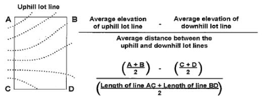
[Ord. 08-29, 2008].
21.05.050 Measuring lot width.
a. The width of a lot is calculated as horizontal distance between the side property lines of a lot, measured at right angles to the lot depth at the rear of the required front yard setback. See Figure 2.
Figure 2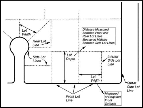
LOT DEPTH AND LOT WIDTH
(The diagram is illustrative)
b. The pole portion of a flag-shaped lot shall be disregarded in calculating lot width. See Figure 3.
Figure 3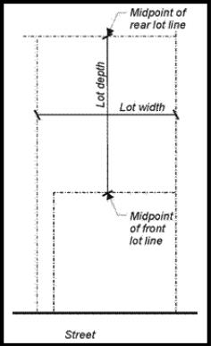
FLAG LOT DEPTH AND LOT WIDTH
(The diagram is illustrative)
[Ord. 08-29, 2008].