


Chapter 12.06
ADDRESSING AND STREET NAMING
Sections:
12.06.030 Implementation and responsibilities.
12.06.060 Reference point and base lines.
12.06.070 Grid lines and numbers.
12.06.100 Installation and display of addresses.
12.06.110 Street designations.
12.06.120 Street naming policy.
12.06.130 Naming of new streets or existing unnamed streets.
12.06.140 Renaming of existing duplicate street names.
12.06.150 Renaming of streets.
12.06.170 Controversial or disputed street names.
12.06.180 Enforcement—Violations.
12.06.010 Purpose.
This chapter further implements portions of the city of Valdez comprehensive plan and supplements the zoning and subdivision ordinances. Its purpose is to provide residents of Valdez with a uniform system of street naming and addressing to:
A. Minimize future street name and addressing conflicts;
B. Provide a database for city records and enhanced 911 services;
C. Expedite property identification by emergency services;
D. Establish standards for the assignment of addresses within the city of Valdez; and
E. Comply with U.S. postal addressing abbreviation standards. (Ord. 21-03 § 1)
12.06.020 Applicability.
A. This chapter shall apply to all property and to all public and private streets in the city of Valdez.
B. Address number sequencing and patterns shall adhere to the National Emergency Number Association (NENA) standards and best practices as well as the state of Alaska’s 911 and Dispatch Consolidation Working Group addressing requirements. Compliance with current standard models may require the changing of nonsequential or nonconforming addresses to be compatible with current and future enhanced 911 systems.
C. Nothing herein shall be construed or interpreted in such a manner as to prevent the planning department from deviating on a case-by-case basis from these standards, procedures and guidelines when deemed necessary to produce a more consistent and logical numbering system.
D. When practically possible, all newly assigned addresses will conform to the standards described in this chapter; however, consideration should be given to the existing patterns and systems previously used in Valdez. (Ord. 21-03 § 1)
12.06.030 Implementation and responsibilities.
A. The planning director shall have the responsibility of administering, enforcing, and maintaining an addressing and street naming standard as defined by this chapter and have the enforcement authority for addressing on buildings as specified in Section 16.16.160 and by the International Fire Code as adopted by the city of Valdez.
B. The planning director or designee shall establish uniform street address numbering procedures. The planning director or their designee shall assign all official street address numbers. A permanent address shall be assigned only for property that is subject to a city-approved plat depicting the dedicated right-of-way serving the property.
C. Property owners are responsible for placing alphanumeric identification in accordance with Section 12.06.100, including placement of private street signs. Posting of addresses and street names must be completed prior to the issuance of a certificate of occupancy. (Ord. 21-03 § 1)
12.06.040 Document protocol.
For document clarity, references to all vehicle paths of travel serving three or more properties, residences, or businesses are referred to as “streets.” Driveways or other vehicle paths of travel serving less than three properties, residences, or businesses shall not be named to reduce administrative costs, but shall have addresses installed and placed as required herein to minimize the potential for confusion for emergency service providers. (Ord. 21-03 § 1)
12.06.050 Address grid.
The system is based on a grid transposed over the city. A north-south and east-west axis from which grid lines extend are the base lines. The intersection of these base lines is the reference point to which all numbers will be related. (Ord. 21-03 § 1)
12.06.060 Reference point and base lines.
The reference point for the city’s address system will be the point where the Egan Street/Richardson Highway centerline intersects with the Meals Avenue centerline. The sequence of property numbers throughout the city will extend outward from this point in four directions—north, south, east and west along the base lines. (See Figure 1)
FIGURE 1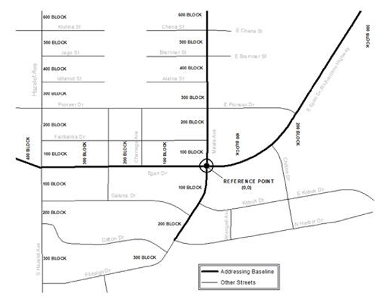
(Ord. 21-03 § 1)
12.06.070 Grid lines and numbers.
Grid lines are generally parallel to base lines. These lines indicate the division between blocks. Each grid line or block marks the change from one hundred to the next hundred. Grid lines are extended from one block to the next where streets do not go through as with cul-de-sacs and with curvilinear streets. (Ord. 21-03 § 1)
12.06.080 Interval distance.
A. The interval distance varies within the city. This is due to the variation in lot and block size. Smaller lots and blocks in the central area require a smaller interval whereas rural subdivision lots and blocks increase in size and require a greater interval distance. The following is a summary of the interval distances used:
|
Central Valdez |
20-foot interval |
|
Mineral Creek Loop Road |
not determined |
|
Robe River |
50-foot interval |
|
Alpine Woods |
50-foot interval |
|
Richardson Highway |
100-foot interval |
B. New subdivisions and development should be assigned either a twenty-foot or fifty-foot interval to avoid complication of the system.
C. Development along the Richardson Highway shall be assigned an address based on a one-hundred-foot interval. “Blocks” along the Richardson Highway equal a distance of one thousand feet. (Ord. 21-03 § 1)
12.06.090 Number assignments.
The following is the recommended method of assigning addresses (house numbers) to different types of buildings:
A. Even numbers shall be assigned to the left side of streets and odd numbers to the right as the numbers increase outward from the reference point.
B. Street address numbers shall be based on the location of vehicular access unless a deviation is approved by the planning director or their designee.
C. A single-family dwelling structure shall be assigned one address number for the structure.
D. A duplex, townhouse or condominium located side by side shall be assigned one address number for each separate residential unit entrance.
E. A duplex, townhouse or condominium with an upper and lower residential unit shall be assigned one address number followed by the letter A for the ground level unit, and the letter B for the second floor unit.
F. A single multifamily dwelling structure shall be assigned one number for the structure. The addresses for individual dwellings within the structure shall be three-digit numbers with the first digit representing the floor level of the entrance, and unit numbers assigned from left to right when facing the front of the structure, e.g., 151 Alatna Street, Apt. 202 (second-floor apartment, second from left when facing the front of the structure).
G. Multifamily Complexes with Multiple Structures.
1. Each structure within a multifamily or multi-unit complex shall be assigned a separate numerical address.
2. Each residential unit shall have a three-digit unit number affixed adjacent to or on the main entry door; e.g., Apt. 202.
3. Multifamily complexes shall post a site plan sign at the main entrance that denotes actual building locations within the complex.
H. Business and Commercial Offices or Complexes.
1. Businesses or offices facing the street on the ground floor with independent entrances shall be assigned one address number.
2. Multiple individual businesses or offices located within a building with two or more floors shall be assigned a three-digit suite number with the first digit representing the floor level of the entrance to the suite, and the second two digits representing the unit number, beginning at 01 for the unit on the far left, when facing the front of the structure; e.g., Suite 201 will represent a second-floor office on the far left of the building when facing the front of the structure.
I. Mobile Home Parks. Mobile home parks shall submit a site plan, identifying individual space numbers, for approval by the planning department and in compliance with the International Fire Code as adopted by the city of Valdez. Space numbers shall be a minimum of five inches in height and be made of retroreflective materials readily visible by emergency responders. (Ord. 21-03 § 1)
12.06.100 Installation and display of addresses.
A. Address numbers shall be located as to be readily visible by emergency responders and shall be positioned to allow exterior illumination of the numbers.
B. Address numbers shall be a minimum of five inches in height and be made of retroreflective materials. Acceptable materials are engineer-grade reflective material (ASTM D4956) equivalent or better. Nonreflective materials may be used if the numbers are lit by at least a one thousand five hundred lumen white light source as to make the numbers visible from the nearest public right-of-way.
C. If a structure is more than one hundred fifty feet from the street, its address shall be posted at the intersection of its access street and public or private street, no less than four feet nor more than six feet above the ground on a substantial, maintained support structure such as a sign or a post. The roadside address characters shall be less than twenty-five feet from the edge of the road. The view of an address from the street must be unobstructed and maintained. The fire department may approve alternative signage. (Ord. 21-03 § 1)
12.06.110 Street designations.
Designation of streets within the city of Valdez shall be in accordance with the following NENA standards except in the case of existing and recorded street designations:
A. Streets which have a definite north-south direction shall be designated as “avenues.” Streets which have a definite east-west directional course shall be designated as “streets.”
B. Streets which do not have a definite directional course and considered to be a secondary thoroughfare shall be designated as a “road” or “drive.”
C. Private roads shall be designated “lane” or “trail.”
D. A short drive which has its ingress and egress on the same road shall be called a “loop.”
E. A short road which returns to itself shall be designated as a “circle.”
F. The designation “boulevard” shall be reserved for long, continuous streets characterized by a broad right-of-way, with tree and turf embellishment, and carrying predominantly noncommercial traffic. (Ord. 21-03 § 1)
12.06.120 Street naming policy.
In selecting street names, consideration shall be given to the following:
A. There shall be no conflict of existing street names within the existing emergency 911 jurisdictional boundary.
B. Street names of similar pronunciation and/or spelling shall be prohibited; e.g., Briar Lane, Brier Lane. The planning department shall coordinate with the fire department and police department to ensure compliance with this requirement.
C. Variations of the same street name with different street designations shall be prohibited within the first word of the two-word title or in the street extension; e.g., Pine Road, Pine Drive, Pine Lane.
D. No street name may consist of more than two words or contain more than fourteen letters, excluding the extension; e.g., street, lane, court, etc. The city council may approve street names with more words or letters; e.g., Martin Luther King Ave., in special situations.
E. Names shall be chosen that reflect objects or historic personages that relate to Alaska in general and to the area specifically and be commensurate with scale and location of the street or the buildings accessed by the street.
F. Roads within subdivisions submitted pursuant to the subdivision plat procedure shall have names that follow a certain theme. New streets added after the establishment of the subdivision shall have street names that follow the same theme. An existing street name shall be continued when the new road extends the alignment of an existing road.
G. Numerical names (1st, 2nd, 3rd, etc.); alphabetical letters (A, B, C, etc.); given and surnames of living persons; complicated, or undesirable names and unconventional spellings, shall be avoided. (Ord. 21-03 § 1)
12.06.130 Naming of new streets or existing unnamed streets.
Any new street established within the city of Valdez, or an existing unnamed street, whether public or private, shall require a street name approved by the planning and zoning commission. Where streets are included on a plat, the proposed street names shall be specified on the final plat map, and shall comply with the requirements set forth in this chapter. (Ord. 21-03 § 1)
12.06.140 Renaming of existing duplicate street names.
The renaming of existing duplicate street names will be required in those cases where the general health and safety of the public is at risk, i.e., where the street name impedes rapid property identification by emergency services. Where duplicate names exist, the street serving the largest number of improved properties shall retain its name. The other streets shall be renamed in accordance with the procedures set forth in this chapter with the input of abutting property owners. The planning department shall coordinate with the fire department and police department to ensure compliance with this requirement. The planning and zoning commission shall have authority to approve all new street names established under this section. (Ord. 21-03 § 1)
12.06.150 Renaming of streets.
Abutting property owners may request to officially name or rename a street by submitting a written petition to the planning department on a form provided by the city. The petition shall bear the signatures of the owners of at least fifty-one percent of the lots, tracts, or parcels of property (excluding federal, state, public utilities, and municipal lands) served by the street to be named. The percentage of owners shall be expressed in terms of both number of properties and land area. The planning department shall notify all abutting property owners of the request by first class mail. Tax assessment records shall be used for owner address information. Property owners shall have thirty days to respond. The planning department shall give due consideration to any and all street name petitions only after all street naming requirements of this chapter are met. Street names shall not be changed by petition more than once every five years.
The planning and zoning commission shall have the authority to approve all requests to rename streets under this section. Costs and fees associated with renaming of streets, including replacement of existing street signs, shall be established by resolution of the city council. (Ord. 21-03 § 1)
12.06.160 Street name signs.
The public works director or their designee is responsible for erecting and maintaining public street signs at street intersections within the boundaries of the city. Property owners are responsible for erecting and maintaining private street signs. (Ord. 21-03 § 1)
12.06.170 Controversial or disputed street names.
The planning department shall have the discretion to refer any disputed street names, addressing issues, or controversial street name changes to the planning and zoning commission or to the city council for approval or resolution. (Ord. 21-03 § 1)
12.06.180 Enforcement—Violations.
A. It shall be unlawful for any person to:
1. Erect or install a street name sign not in accordance with this chapter;
2. Remove, alter, change, or deface a street sign or address identification erected or installed as provided herein;
3. Place or post addresses not in compliance with this chapter; or
4. Place or post an address that is not readily visible from the street.
B. Enforcement procedures and penalties resulting from violations of this chapter shall be administered pursuant to Chapter 1.08. (Ord. 21-03 § 1)